The platform is the means, not the end goal
|
|
|
- Arline Perry
- 5 years ago
- Views:
Transcription


1


2 The platform is the means, not the end goal +

3 Complete analytics platform at an accessible price point Compliments existing workflows by integrating with the new intelligent farm equipment. The goal is a single step for the farmer, from the drone flight to the next farm management action.


4 AGRICULTURE + Crop health indices + Plant height + Canopy cover + Weed detection + Season monitoring OIL & GAS + Oil spill tracking + Pipeline monitoring + Environmental assessment ENVIRONMENT & CLIMATE + Land cover mapping + Carbon capping + Renewable energy WATER + Irrigated land mapping + Impervious surface mapping + Watershed planning DISASTER RESPONSE + Wildfire + Flooding + Damage assessment + Rapid response FORESTRY + Biomass + Forest health + Disease detection UTILITIES + Vegetation management + NERC ROW monitoring + Asset verification INSURANCE + Crop claims assessment + Structural damage assessment + Underwriting and reinsurance validation


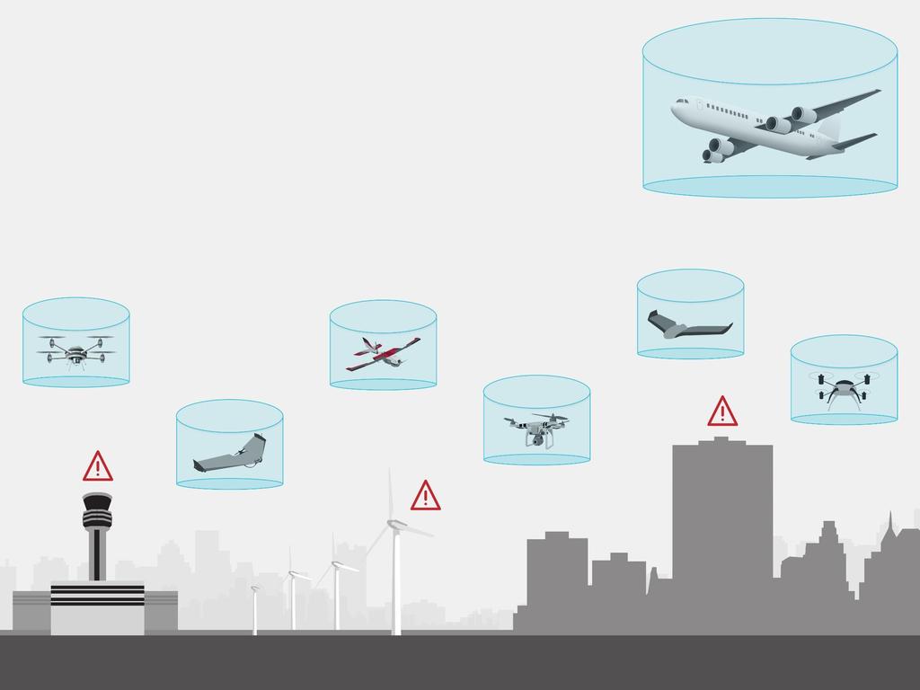
5 How does the current regulatory environment impact agricultural use? Current Needed Visual Line-of-Sight Operations Only + Beyond Visual Line-of-Sight with option to transit between fields 2 Person (Minimum) Team Solo Pilot in Command FAA Sport Pilot License (minimum) and FAA Medical Lengthy approval processes Minimal training with no formal manned aircraft certification Streamlined regulatory compliance, routine use Where are the roadblocks and how can we resolve them?


6 The system must accommodate rising demand


7 Integrating new technologies into the NAS
8 How do these new technologies change the risk profile on nationwide scale? Highly localized experiments to date not sufficiently answering the questions we have The paradox: we can t operate at a nationwide scale without data to make the safety case, but we can t get the data we need unless we operate at nationwide scale Whitepaper available at: Integrating new technologies into the NAS

9 Drive creation of concept of operations for subsection of Class G Current small scale operations to understand risk: Pathfinder UAS test sites ASSURE Extensive research and simulation Operating on a National Level Directly address primary, commercial use cases as defined by market research: precision ag, critical infrastructure surveillance Assessing how technologies can operate on national scale BUILD ON RESULTS TO DEFINE RISK PROFILE ON NATIONAL SCALE
10 Realizing the vision while mitigating unknown risk Define UAS Service Volume (USV): Class G Low population density Land designated for agriculture or critical infrastructure use What does this look like? Consider an area covering Louisiana and part of Texas BUILD ON RESULTS TO DEFINE RISK PROFILE ON NATIONAL SCALE
11 Realizing the vision while mitigating unknown risk Define UAS Service Volume (USV): Class G Low population density Land designated for agriculture or critical infrastructure use What does this look like? Consider an area covering Louisiana and part of Texas BUILD ON RESULTS TO DEFINE RISK PROFILE ON NATIONAL SCALE
12 Realizing the vision while mitigating unknown risk Define UAS Service Volume (USV): Class G Low population density Land designated for agriculture or critical infrastructure use What does this look like? Consider an area covering Louisiana and part of Texas BUILD ON RESULTS TO DEFINE RISK PROFILE ON NATIONAL SCALE

13 Realizing the vision while mitigating unknown risk Define UAS Service Volume (USV): Class G Low population density Land designated for agriculture or critical infrastructure use What does this look like? Consider an area covering Louisiana and part of Texas BUILD ON RESULTS TO DEFINE RISK PROFILE ON NATIONAL SCALE

14 Realizing the vision while mitigating unknown risk Define UAS Service Volume (USV): Class G Low population density Land designated for agriculture or critical infrastructure use What does this look like? Consider an area covering Louisiana and part of Texas BUILD ON RESULTS TO DEFINE RISK PROFILE ON NATIONAL SCALE

15 Realizing the vision while mitigating unknown risk Define UAS Service Volume (USV): Class G Low population density Land designated for agriculture or critical infrastructure use What does this look like? Consider an area covering Louisiana and part of Texas BUILD ON RESULTS TO DEFINE RISK PROFILE ON NATIONAL SCALE

16 BUILD ON RESULTS TO DEFINE RISK PROFILE ON NATIONAL SCALE

17 BUILD ON RESULTS TO DEFINE RISK PROFILE ON NATIONAL SCALE


18 precisionhawk.com
P R O U D LY C A N A D I A N
 P R O U D LY C A N A D I A N 1.855.423.3185 info@rmegeomatics.com AERIAL SURVEYING IMAGING TERRAIN ANALYSIS WHO WE ARE HSE & REGULATORY CLIENT INDUSTRIES RME Geomatics (formerly NGF Geomatics) was founded
UAV APPLICATIONS IN ENGINEERING. Presented By Wohnrade Civil Engineers, Inc.
 UAV APPLICATIONS IN ENGINEERING Presented By Wohnrade Civil Engineers, Inc. UAV BUSINESS STARTUP March 31, 2015 - Obtained DJI Inspire 1 Unmanned Aerial Vehicle (UAV) FAA requires Certificate of Authorization
Global UAV-based solutions for the industry and agriculture.
 Global UAV-based solutions for the industry and agriculture. Remote sensing of vegetation from drones (UAS). The example of the Trimble Unmanned Aerial Solution Emmanuel de Maistre, co-founder & CEO demaistre@redbird.fr
USGS Hydrography Overview. May 9, 2018
 + 1 USGS Hydrography Overview May 9, 2018 + 2 The National Geospatial Program Provides the geospatial baseline of the Nation s topography, natural landscape and built environment through The National Map,
Earth Observation Satellites Dawn of Application Specific Satellite Data. Date: 26 July 2017
 Earth Observation Satellites Dawn of Application Specific Satellite Data Date: 26 July 2017 Introducing a World of New Possibilities Satellite imagery is a critical fountain of information on al levels
Remote Sensing Geographic Information Systems Global Positioning Systems
 Remote Sensing Geographic Information Systems Global Positioning Systems Assessing Seasonal Vegetation Response to Drought Lei Ji Department of Geography University of Nebraska-Lincoln AVHRR-NDVI: July
Land Cover Classification Mapping & its uses for Planning
 Land Cover Classification Mapping & its uses for Planning What is Land Cover Classification Mapping? Examples of an actual product Why use Land Cover Classification Mapping for planning? Possible uses
Observation (EO) & Geomatics in Canada
 & Geomatics in Canada") Innovating to Increase the Impact of Earth Observation (EO) & Geomatics in Canada Natural Resources Canada February 25, 2014 Prashant Shukle, Director General Canada Centre for Mapping and Earth Observation
Innovating to Increase the Impact of Earth Observation (EO) & Geomatics in Canada Natural Resources Canada February 25, 2014 Prashant Shukle, Director General Canada Centre for Mapping and Earth Observation
Copernicus Overview. Major Emergency Management Conference Athlone 2017
 Copernicus Overview Major Emergency Management Conference Athlone 2017 Copernicus is a European programme implemented by the European Commission. The services address six thematic areas: land, marine,
SUPPORTS SUSTAINABLE GROWTH
 DDSS BBUUN NDDLLEE G E O S P AT I A L G O V E R N A N C E P A C K A G E SUPPORTS SUSTAINABLE GROWTH www.digitalglobe.com BRISBANE, AUSTRALIA WORLDVIEW-3 30 CM International Civil Government Programs US
European Space Agency
 Guidelines - Guidelines how/when to interact during the WebEx session: - Due to the number of attendees, please keep always your webcam and microphone switched-off - You can use anytime the chat to all
AUTOMATED DATA PROCESSING FOR MARITIME AND FLOODS APPLICATIONS
 YOUR HUB FOR GEOSPATIAL APPLICATIONS AUTOMATED DATA PROCESSING FOR MARITIME AND FLOODS APPLICATIONS Angelucci Maria, Daffina Filippo, Grandoni Domenico, Quattrociocchi Dino Automated Data Processing (Smart
Understanding Weather and Climate Risk. Matthew Perry Sharing an Uncertain World Conference The Geological Society, 13 July 2017
 Understanding Weather and Climate Risk Matthew Perry Sharing an Uncertain World Conference The Geological Society, 13 July 2017 What is risk in a weather and climate context? Hazard: something with the
World Meteorological Organization
 World Meteorological Organization Opportunities and Challenges for Development of Weather-based Insurance and Derivatives Markets in Developing Countries By Maryam Golnaraghi, Ph.D. Head of WMO Disaster
By Lillian Ntshwarisang Department of Meteorological Services Phone:
 By Lillian Ntshwarisang Department of Meteorological Services Phone: +267 3612200 Email: lntshwarisang@gov.bw/ lntshwarisang@gmail.com Introduction Mandate of DMS Function of the Department Services to
R E D U C E C O S T S A N D E N H A N C E S A F E T Y W I T H U A S S K Y F I R E C O N S U L T I N G. C O M
 PUBLIC SAFETY UAS R E D U C E C O S T S A N D E N H A N C E S A F E T Y W I T H U A S WHY TRUST SKYFIRE? Founded by emergency response professionals, nobody has helped more public safety agencies create
USING 3D GIS TO ASSESS ENVIRONMENTAL FLOOD HAZARDS IN MINA
 King Fahd University of Petroleum & Minerals College of Environmental Design Geographical Information system USING 3D GIS TO ASSESS ENVIRONMENTAL FLOOD HAZARDS IN MINA Prepared by : Ali AL-Zahrani OUTLINE
Land Administration and Cadastre
 Geomatics play a major role in hydropower, land and water resources and other infrastructure projects. Lahmeyer International s (LI) worldwide projects require a wide range of approaches to the integration
The Federal Geospatial Platform (FGP) and Open Maps Canada. Eric Loubier, Director Natural Resources Canada Earth Sciences Sector
 and Open Maps Canada. Eric Loubier, Director Natural Resources Canada Earth Sciences Sector") The Federal Geospatial Platform (FGP) and Open Maps Canada Eric Loubier, Director Natural Resources Canada Earth Sciences Sector May 2016 Geospatial data are produced and widely used in the federal government
The Federal Geospatial Platform (FGP) and Open Maps Canada Eric Loubier, Director Natural Resources Canada Earth Sciences Sector May 2016 Geospatial data are produced and widely used in the federal government
BLUEFIELDS EMERGENCY PLATFORM:
 BLUEFIELDS EMERGENCY PLATFORM: Community Early Warning Systems for Mitigating Hydro-Meteorological Impacts in Bluefields, Jamaica T. Hyman, J. Horney, B. Carby, K. Miller, M. Taylor OUTLINE Background
The current status, functions, challenges and needs of South Sudan Meteorological Department (SSMD)
") The current status, functions, challenges and needs of South Sudan Meteorological Department (SSMD) Presented: by Mojwok Ogawi Modo, South Sudan Meteorological Department. Background The present SSMD was
The current status, functions, challenges and needs of South Sudan Meteorological Department (SSMD) Presented: by Mojwok Ogawi Modo, South Sudan Meteorological Department. Background The present SSMD was
Assessment and valuation of Ecosystem Services for decision-makers
 Assessment and valuation of Ecosystem Services for decision-makers An introduction to the ARIES approach Ferdinando Villa *, Ken Bagstad Gary Johnson, Marta Ceroni *Basque Center for Climate Change, Bilbao,
Status and Challenges on Geo-DRM Information Systems in Tonga
 Name: Mafua- i-vai utukakau Maka Status and Challenges on Geo-DRM Information Systems in Tonga 1 Roles and Relationships Land and Geographic Information Systems (LGIS) Unit: Establish updated high-resolution
Creating a Staff Development Plan with Esri
 Creating a Staff Development Plan with Esri Michael Green David Schneider Guest Presenter: Shane Feirer, University of California Esri UC 2014 Technical Workshop Agenda What is a Staff Development Plan?
Unique Vaisala Global Lightning Dataset GLD360 TM
 Unique Vaisala Global Lightning Dataset GLD360 TM / THE ONLY LIGHTNING DETECTION NETWORK CAPABLE OF DELIVERING HIGH-QUALITY DATA ANYWHERE IN THE WORLD GLD360 provides high-quality lightning data anywhere
FROM WATER LEAKS TO WINE GRAPES: A NEW OUTLOOK FOR IMAGERY ANALYSIS
 Place image here (10 x 3.5 ) FROM WATER LEAKS TO WINE GRAPES: A NEW OUTLOOK FOR IMAGERY ANALYSIS ENVI AS A FRAMEWORK FOR CLOUD SERVICES & DEEP LEARNING Presented By Gordon Sumerling on Behalf of Cherie
Unique Vaisala Global Lightning Dataset GLD360 TM
 Unique Vaisala Global Lightning Dataset GLD360 TM / THE ONLY LIGHTNING DETECTION NETWORK CAPABLE OF DELIVERING SUCH HIGH-QUALITY DATA ANYWHERE IN THE WORLD GLD360 provides high-quality lightning data anywhere
Summary of Available Datasets that are Relevant to Flood Risk Characterization
 Inter-Agency Characterization Workshop February 25-27, 2014 USACE Institute for Water Resources, Alexandria, VA, IWR Classroom Summary of Available Datasets that are Relevant to Characterization National
GEOMATICS. Shaping our world. A company of
 GEOMATICS Shaping our world A company of OUR EXPERTISE Geomatics Geomatics plays a mayor role in hydropower, land and water resources, urban development, transport & mobility, renewable energy, and infrastructure
Doppler Weather Radars and Weather Decision Support for DP Vessels
 Author s Name Name of the Paper Session DYNAMIC POSITIONING CONFERENCE October 14-15, 2014 RISK SESSION Doppler Weather Radars and By Michael D. Eilts and Mike Arellano Weather Decision Technologies, Inc.
CONTENTS. Foreword... Summary (English, French, Russian, Spanish) 1. Introduction by R. Schneider
 1. Introduction by R. Schneider") CONTENTS Page Foreword............ IX Summary (English, French, Russian, Spanish) XI 1. Introduction by R. Schneider.. 1 1.1 1.1.1 1.1.2 1.1.3 1.1.4 1.1.5 1.1.6 1.2 1.2.1 1.2.2 1.2.3 The present position
CONTENTS Page Foreword............ IX Summary (English, French, Russian, Spanish) XI 1. Introduction by R. Schneider.. 1 1.1 1.1.1 1.1.2 1.1.3 1.1.4 1.1.5 1.1.6 1.2 1.2.1 1.2.2 1.2.3 The present position
European Topic Centre on Land Urban and Soil Systems. Green Infrastructure at EEA
 Green Infrastructure at EEA A SPATIAL APPROACH TO MAPPING GI Stefan Kleeschulte, ETC ULS GI and territorial cohesion 2011 first EEA report on Green Infrastructure Underlining the need to develop tools
Advanced Image Analysis in Disaster Response
 Advanced Image Analysis in Disaster Response Creating Geographic Knowledge Thomas Harris ITT The information contained in this document pertains to software products and services that are subject to the
Business Preparedness and Hurricane Risk
 Business Preparedness and Hurricane Risk Hurricanes are one of the more predictable natural disasters compared to events such as earthquakes, wildfires and tornadoes. Meteorologists gather data to predict
IMPLEMENTING GOVERNMENT-WIDE ENTERPRISE GIS; THE FEDERATED MODEL
 IMPLEMENTING GOVERNMENT-WIDE ENTERPRISE GIS; THE FEDERATED MODEL James E. Mitchell, Ph. D. IT GIS Manager Louisiana Department of Transportation and Development presented at the ESRI International Users
Technical Drafting, Geographic Information Systems and Computer- Based Cartography
 Technical Drafting, Geographic Information Systems and Computer- Based Cartography Project-Specific and Regional Resource Mapping Services Geographic Information Systems - Spatial Analysis Terrestrial
SCENT: A Smart Toolbox for Engaging Citizens into a People Centric Observation Web. INSPIRE 2016 Conference Barcelona, 28 September 2016
 SCENT: A Smart Toolbox for Engaging Citizens into a People Centric Observation Web INSPIRE 2016 Conference Barcelona, 28 September 2016 Summary SCENT Facts & figures Motivation SCENT @ a glance SCENT objectives
NCAR UCAR. 50 th Anniversary Lecture
 NCAR & UCAR 50 th Anniversary Lecture Turbulence, Wind Shear, Toxin Attacks, and Other Things That Go Bump In the Night: Applied Research for Real-Life Problems Bill Mahoney National Center for Atmospheric
Baldwin County, Alabama
 2015 Baldwin County, Alabama Multi-Hazard Mitigation Plan I. Comprehensive Plan A multi-jurisdiction plan City of Bay Minette City of Daphne Town of Elberta City of Fairhope City of Foley City of Gulf
Commercialisation. Lessons learned from Dutch weather market
 Commercialisation Lessons learned from Dutch weather market Where information comes together weather traffic public transport Weather, traffic and public transport. Daily actual information that influences
Current Research Trends from an Australian Perspective. Dr Philip Collier Research Director
 Current Research Trends from an Australian Perspective Dr Philip Collier Research Director Growth in the spatial sector. 11% pa in the Global Navigation Satellite System market 2010-2020 300% growth in
Future Global Data-processing and Forecasting System (GDPFS)
") Future Global Data-processing and Forecasting System (GDPFS) Enabling Seamless Activities from Research to Operations to Service (R2O2S) for the benefits of Members Michel Jean President of CBS The GDPFS
Future Global Data-processing and Forecasting System (GDPFS) Enabling Seamless Activities from Research to Operations to Service (R2O2S) for the benefits of Members Michel Jean President of CBS The GDPFS
Best Practices Natural Disasters Action Plan
 Best Practices Natural Disasters Action Plan MODERATORS: Jeannie Chiaromonte, CAR Vice President / National Remarketing Manager Bank of America Chuck Novince, CAR Vice President National Accounts Manheim
TRAITS to put you on the map
 TRAITS to put you on the map Know what s where See the big picture Connect the dots Get it right Use where to say WOW Look around Spread the word Make it yours Finding your way Location is associated with
The AIR Bushfire Model for Australia
 The AIR Bushfire Model for Australia In February 2009, amid tripledigit temperatures and drought conditions, fires broke out just north of Melbourne, Australia. Propelled by high winds, as many as 400
Advancing Geoscientific Capability. Geological Survey of Finland
 Advancing Geoscientific Capability Geological Survey of Finland GTK in brief The Geological Survey of Finland (GTK) is one of the largest European centres of excellence in assessment, research and the
Renewable Energy Development and Airborne Wildlife Conservation
 Whitepaper ECHOTRACK TM RADAR ACOUSTIC TM SURVEILLANCE SYSTEM Renewable Energy Development and Airborne Wildlife Conservation Renewable energy developers must meet regulatory requirements to mitigate for
Template for Sediment and Erosion Control Plan General Instructions. Section Instructions
 Template for Sediment and Erosion Control Plan General Instructions Introduction: Soil erosion and sediment deposition from farmlands can contribute to degraded surface water quality. Sediment delivery
High-resolution Satellite Imagery for the Changing World
 High-resolution Satellite Imagery for the Changing World Presented by DigitalGlobe, Jon Song DigitalGlobe Our world is changing rapidly. Global transformations are revolutionizing how humans work, play,
Long Term Plan What is planned for Murchison?
 Long Term Plan 2018-2028 What is planned for Murchison? 1.0 Introduction The following information provides an overview of significant projects Council has planned for the Murchison settlement in the Long
The UN-GGIM: Europe core data initiative to encourage Geographic information supporting Sustainable Development Goals Dominique Laurent, France
 INSPIRE conference Strasbourg 6 September 2017 The UN-GGIM: Europe core data initiative to encourage Geographic information supporting Sustainable Development Goals Dominique Laurent, France Introduction
A Broad View of Geospatial Technology & Systems
 A Broad View of Geospatial Technology & Systems Pete Large Vice President, Trimble On the shoulders of giants 1 Since their time, our ability to generate geospatial information has grown exponentially
sentinel-2 COLOUR VISION FOR COPERNICUS
 sentinel-2 COLOUR VISION FOR COPERNICUS SATELLITES TO SERVE By providing a set of key information services for a wide range of practical applications, Europe s Copernicus programme is providing a step
An Introduction to Day Two. Linking Conservation and Transportation Planning Lakewood, Colorado August 15-16, 16, 2006
 An Introduction to Day Two Linking Conservation and Transportation Planning Lakewood, Colorado August 15-16, 16, 2006 1 Agenda Day One Transportation Planning Heritage Program State Wildlife Action Plan
Fusarium Head Blight (FHB)
") Fusarium Head Blight (FHB) FHB is a Fungal disease of cereal crops that affects kernel development 1999 declared a pest under the Agricultural Pest Act 2002 Alberta released Fusarium Risk Management Plan
Fusarium Head Blight (FHB) FHB is a Fungal disease of cereal crops that affects kernel development 1999 declared a pest under the Agricultural Pest Act 2002 Alberta released Fusarium Risk Management Plan
Status & Challengers of Cook Islands GEO DRM. Cook Islands GEO S/GIS History
 Status & Challengers of Cook Islands GEO DRM By Patrick A. ARIOKA Planning & Advisory Officer EMERGENCY MANAGEMENT COOK ISLANDS Cook Islands GEO S/GIS History 1990 NZODA/MFAT trained by Landcare Research
ENVS S102 Earth and Environment (Cross-listed as GEOG 102) ENVS S110 Introduction to ArcGIS (Cross-listed as GEOG 110)
 ENVS S110 Introduction to ArcGIS (Cross-listed as GEOG 110)") ENVS S102 Earth and Environment (Cross-listed as GEOG 102) 1. Describe the fundamental workings of the atmospheric, hydrospheric, lithospheric, and oceanic systems of Earth 2. Explain the interactions
ENVS S102 Earth and Environment (Cross-listed as GEOG 102) 1. Describe the fundamental workings of the atmospheric, hydrospheric, lithospheric, and oceanic systems of Earth 2. Explain the interactions
Land Use Planning and Agriculture: Austrian Experiences and Challenges I
 Land Use Planning and Agriculture: Austrian Experiences and Challenges I SULANET Summer School 2016 Walter Seher BOKU Vienna 1 Land Use Planning and Agriculture 2 Land Use Planning and Agriculture Agriculture
Hurricane Readiness for Coastal Communities
 Hurricane Readiness for Participant Guide Developed for: Federal Emergency Management Agency Emergency Management Institute 16825 South Seton Avenue Emmitsburg, MD 21727-8998 Developed by: C² Technologies,
Implementation Status & Results Paraguay Paraguay Sustainable Agriculture & Rural Development Project (P088799)
") Public Disclosure Authorized Public Disclosure Authorized The World Bank Implementation Status & Results Paraguay Paraguay Sustainable Agriculture & Rural Development Project (P088799) Operation Name:
Public Disclosure Authorized Public Disclosure Authorized The World Bank Implementation Status & Results Paraguay Paraguay Sustainable Agriculture & Rural Development Project (P088799) Operation Name:
Weather Risk Management. Salah DHOUIB Underwriter Paris Re
 1 Weather Risk Management Salah DHOUIB Underwriter Paris Re 2 T A B L E Index Based Weather Covers Energy Index Based Reinsurance Humanitarian Aid Market Figures 3 Concept of index based weather covers:
A Global Approach to Building a GIS Strategy Esri UC July 15th, 2014
 Scott Sitzman and Paloma Urbano A Global Approach to Building a GIS Strategy Esri UC July 15th, 2014 1 METHODOLOGY 2 GIS Strategy Study Methodology Maturity Model by Carnegie Mellon Current State Review
COMMERCIALISING WEATHER AND CLIMATE SERVICES:
 COMMERCIALISING WEATHER AND CLIMATE SERVICES: THE CASE OF UGANDA BY MICHAEL S.Z. NKALUBO Commissioner for Meteorology/PR of Uganda with WMO Uganda National Meteorological Authority Presentation Outline
An Introduction to NatureServe Linking Conservation and Transportation Planning Phoenix, Arizona November 8 & 9, 2006
 An Introduction to NatureServe Linking Conservation and Transportation Planning Phoenix, Arizona November 8 & 9, 2006 1 NatureServe in Brief An independent, non-profit conservation organization Provides
THE 3D SIMULATION INFORMATION SYSTEM FOR ASSESSING THE FLOODING LOST IN KEELUNG RIVER BASIN
 THE 3D SIMULATION INFORMATION SYSTEM FOR ASSESSING THE FLOODING LOST IN KEELUNG RIVER BASIN Kuo-Chung Wen *, Tsung-Hsing Huang ** * Associate Professor, Chinese Culture University, Taipei **Master, Chinese
Impact Policies Enabling Value Enhancement of Geospatial Information in Canadian Economy and Society
 1 Impact Policies Enabling Value Enhancement of Geospatial Information in Canadian Economy and Society May 26, 2015 Prashant Shukle, Director General Canada Centre for Mapping and Earth Observation Increased
Polar. Thematic Exploitation Platform. Andrew Fleming, BAS/Polar View ESRIN, 14 th October 2015
 Polar Thematic Exploitation Platform Andrew Fleming, BAS/Polar View ESRIN, 14 th October 2015 Why a Polar TEP? Polar regions play an important role in regulating and driving the global climate & experiencing
DANIEL WILSON AND BEN CONKLIN. Integrating AI with Foundation Intelligence for Actionable Intelligence
 DANIEL WILSON AND BEN CONKLIN Integrating AI with Foundation Intelligence for Actionable Intelligence INTEGRATING AI WITH FOUNDATION INTELLIGENCE FOR ACTIONABLE INTELLIGENCE in an arms race for artificial
NOAA s Regional Climate Science & Information: Opportunities and Challenges
 NOAA s Regional Climate Science & Information: Opportunities and Challenges Dr. Wayne Higgins Climate Program Office, Director Office of Oceanic and Atmospheric Research National Oceanic and Atmospheric
Crows Landing Naval Base Easement
 1 of 15 West Stanislaus Resource Conservation District Crows Landing Naval Base Easement Annual Reserve Monitoring Report Jamie McFarlin 11/112012 2 of 15 West Stanislaus Resource Conservation District
Impact on Agriculture
 Weather Variability and the Impact on Agriculture InfoAg 2017 Copyright 2017, awhere. All Rights Reserved The Problem: The Earth s Atmosphere is a Heat Engine In transition 1 C warming of atmosphere Triples
Chippewa County Natural Hazards Mitigation Plan
 2014 Chippewa County Natural Hazards Mitigation Plan Prepared for: Chippewa County Office of Emergency Management With the Assistance of: Eastern U.P. Regional Planning & Development Commission April,
Abdolreza Ansari Amoli. Remote Sensing Department Iranian Space Agency
 Risk Assessment and Mapping Using Earth Observation Data In Iran Abdolreza Ansari Amoli Remote Sensing & GIS Expert Remote Sensing Department Iranian Space Agency Different Types of Disasters in Iran Epidemic
WSI Pilotbrief Optima - for ipad
 WSI Pilotbrief Optima - for ipad Anticipate, Visualize & Avoid Hazardous Weather In A Whole New Way The Weather Company, an IBM Business, delivers an ipad-based version of WSI Pilotbrief Optima. This ipad
A New Approach to GIS at the Ministry for Primary Industries New Zealand
 A New Approach to GIS at the Ministry for Primary Industries New Zealand Alana Corney and André Post Geospatial Management Team www.mpi.govt.nz 1 Overview Who we are and what we do Our Approach Building
Unmanned Aircraft Systems (UAS) Activities in Earth Sciences
 Activities in Earth Sciences") Unmanned Aircraft Systems (UAS) Activities in Earth Sciences Bruce K. Quirk quirk@usgs.gov Department of the Interior U.S. Geological Survey June 22, 2015 Department of the Interior Bureau of Land Management
Unmanned Aircraft Systems (UAS) Activities in Earth Sciences Bruce K. Quirk quirk@usgs.gov Department of the Interior U.S. Geological Survey June 22, 2015 Department of the Interior Bureau of Land Management
16540/14 EE/cm 1 DG E 1A
 Council of the European Union Brussels, 5 December 2014 (OR. en) 16540/14 ENV 965 CULT 139 NOTE From: To: Subject: General Secretariat of the Council Delegations Charter of Rome on Natural and Cultural
Programmatic Approaches to Assessing and Mitigating Risk to Pipelines from Natural Forces
 Programmatic Approaches to Assessing and Mitigating Risk to Pipelines from Natural Forces 23 rd International Petroleum Environmental Conference New Orleans, Louisiana November 8-10, 2016 Introduction
Barnabas Chipindu, Department of Physics, University of Zimbabwe
 DEFICIENCIES IN THE OPERATIONAL APPLICATIONS OF LONG - RANGE WEATHER PREDICTIONS FOR AGRICULTURE - RECOMMENDATIONS FOR IMPROVING THE TECHNOLOGY FOR THE BENEFIT OF AGRICULTURE AT THE NATIONAL AND REGIONAL
DRRM in the Philippines: DRRM Projects, Geoportals and Socio-Economic Integration
 Regional workshop on Geo-referenced information system for improving disaster risk preparedness and management in Asia and the Pacific 26-27 June 2014, UNCC, Bangkok, Thailand DRRM in the Philippines:
Climate Resilience Decision Making Framework in the Caribbean. A case of Spatial Data Management
 Climate Resilience Decision Making Framework in the Caribbean A case of Spatial Data Management Bishwa Pandey Sr. Data Management Specialist The World Bank Background The mission of The World Bank s Latin
Catastrophic Events Impact on Ecosystems
 Catastrophic Events Impact on Ecosystems Hurricanes Hurricanes An intense, rotating oceanic weather system with sustained winds of at least 74 mph and a welldefined eye Conditions for formation: Warm water
Land Accounts - The Canadian Experience
 Land Accounts - The Canadian Experience Development of a Geospatial database to measure the effect of human activity on the environment Who is doing Land Accounts Statistics Canada (national) Component
MISSOURI LiDAR Stakeholders Meeting
 MISSOURI LiDAR Stakeholders Meeting East-West Gateway June 18, 2010 Tim Haithcoat Missouri GIO Enhanced Elevation Data What s different about it? Business requirements are changing.fast New data collection
University of Lusaka
 University of Lusaka BSPH 315 Health Mapping & GIS Topic: Background of GIS Content: 1. Aim of the course 2. What do you know about GIS? 3. Difference between geographic data and geographic information
DEVELOPMENT AND APPLICATION OF HIGH- RESOLUTION GIS-BASED ATLAS TO ENHANCE WATERSHED MANAGEMENT IN THE PHILIPPINES
 DEVELOPMENT AND APPLICATION OF HIGH- RESOLUTION GIS-BASED ATLAS TO ENHANCE WATERSHED MANAGEMENT IN THE PHILIPPINES Nathaniel C. Bantayan Institute of Renewable Natural Resources College of Forestry and
Physical Geography: Patterns, Processes, and Interactions, Grade 11, University/College Expectations
 Geographic Foundations: Space and Systems SSV.01 explain major theories of the origin and internal structure of the earth; Page 1 SSV.02 demonstrate an understanding of the principal features of the earth
Global Catastrophes and Climate: Discussion from a Reinsurer Perspective Thomas Leidell, Tokio Millennium Re Ltd.
 Monday, May 1, 2017 OPENING PCS 2016 Year in Review Ted Gregory, Property Claim Services, Verisk Analytics Working Together on Colorado Catastrophes Marguerite Salazar, Colorado Insurance Commissioner
Chapter : 1 : Introduction of GIS
 History of GIS : Chapter : 1 : Introduction of GIS In 1960 the Department of Forestry and Rural Department of Canada has decided to pursue a large-scale project to manage the resources. The initial task
Disaster Management and Spatial Data An Experience of Sri Lanka for Joint project team meeting 2012
 Disaster Management and Spatial Data An Experience of Sri Lanka for Joint project team meeting 2012 1 by Padma Kumara Withana Provincial Surveyor General Uva Province 2 Out line ü Introduction ü Natural
Scott Sitzman and Paloma Urbano. A Global Approach to Building a GIS Strategy. Esri Petroleum Conference April 2014
 Scott Sitzman and Paloma Urbano A Global Approach to Building a GIS Strategy Esri Petroleum Conference April 2014 1 GIS Strategy Study Methodology Maturity Model by Carnegie Mellon Current State Review
GIS Building Communities beyond National Borders (Building Successful Spatial Data Infrastructures) Nick Land, ESRI Europe
 Nick Land, ESRI Europe") GIS Building Communities beyond National Borders (Building Successful Spatial Data Infrastructures) Nick Land, ESRI Europe UK worst flooding in the last 60 years 350,000 households without drinking water
GIS Building Communities beyond National Borders (Building Successful Spatial Data Infrastructures) Nick Land, ESRI Europe UK worst flooding in the last 60 years 350,000 households without drinking water
GIS Workshop Data Collection Techniques
 GIS Workshop Data Collection Techniques NOFNEC Conference 2016 Presented by: Matawa First Nations Management Jennifer Duncan and Charlene Wagenaar, Geomatics Technicians, Four Rivers Department QA #: FRG
Geospatial Technologies
 An Overview of Prepared by: John McGee Jennifer McKee With support from: NSF DUE-0903270 in partnership with: Geospatial Technician Education Through Virginia s Community Colleges (GTEVCC) What is Geospatial?
Name period date assigned date due date returned. Natural Disasters
 Name period date assigned date due date returned Match the following natural disaster to its description. Write the capital letter of the definition in the blank in front of the natural disaster. 1. tornado
State-of-the-Art GIS as an Integrating Technology
 Paper # 104: GIS for Oil Spill Prevention & Response Devon Humphrey Instructor, National Spill Control School Texas A&M University at Corpus Christi, TX Introduction and History The National Spill Control
Deep Thunder. Local Area Precision Forecasting for Weather-Sensitive Business Operations (e.g. Electric Utility)
") 1 Deep Thunder Local Area Precision Forecasting for Weather-Sensitive Business Operations (e.g. Electric Utility) Dipl. Ing. Helmut Ludwar Chief Technologist Wien, im Oktober 2010 Forecasts for Weather-Sensitive
1 Deep Thunder Local Area Precision Forecasting for Weather-Sensitive Business Operations (e.g. Electric Utility) Dipl. Ing. Helmut Ludwar Chief Technologist Wien, im Oktober 2010 Forecasts for Weather-Sensitive
Economic Benefit Study on Value of Spatial Information Australian Experience
 Economic Benefit Study on Value of Spatial Information Australian Experience Dr Zaffar Sadiq Mohamed-Ghouse Director, International Relations Cooperative Research Centre for Spatial Information zsadiq@crcsi.com.au
13.2 USING VIRTUAL GLOBES TO IMPROVE SITUATIONAL AWARENESS IN THE NATIONAL WEATHER SERVICE
 13.2 USING VIRTUAL GLOBES TO IMPROVE SITUATIONAL AWARENESS IN THE NATIONAL WEATHER SERVICE Andy Foster* National Weather Service Springfield, Missouri* Keith Stellman National Weather Service Shreveport,
Emergency Management Service (EMS) mapping
 mapping") GMES Emergency Management Service (EMS) mapping Frédéric BASTIDE GMES unit, European Commission UN-SPIDER Expert Meeting: "Crowdsource Mapping for Disaster Risk Management and Emergency Response" 3-5 December,
GMES Emergency Management Service (EMS) mapping Frédéric BASTIDE GMES unit, European Commission UN-SPIDER Expert Meeting: "Crowdsource Mapping for Disaster Risk Management and Emergency Response" 3-5 December,