AUTOMATED DATA PROCESSING FOR MARITIME AND FLOODS APPLICATIONS
|
|
|
- Cynthia Atkins
- 5 years ago
- Views:
Transcription

1 YOUR HUB FOR GEOSPATIAL APPLICATIONS AUTOMATED DATA PROCESSING FOR MARITIME AND FLOODS APPLICATIONS Angelucci Maria, Daffina Filippo, Grandoni Domenico, Quattrociocchi Dino

2 Automated Data Processing

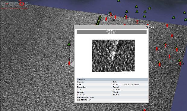
3 (Smart Eyes on the SEas) SEnSE is the e-geos new Maritime Surveillance Platform, providing a synoptic view and access to maritime or tailored information, including Geospatial Analysis and early warning notifications, based on criteria established with the users. SEnSE delivers Maritime Domain Awareness information in Near Real Time, leverages on e- GEOS proprietary toolkit, for an advanced exploitation of COSMO-SkyMed and multi-mission satellite data, integrating marine traffic data (e.g. SatAIS, AIS), met-ocean and open source data. Communication tools WEBSITE VIDEO o/sense.mp4 BROCHURE esense_okfeb2016.pdf?web=1


4 SEnSE: Product Overview Multi-sensor data ingestion Automatic data processing and feature extraction Near Real Rime and (secure) easy access e-geos assets Matera Space Center and the GeoStations Network allows global and fast data access Proprietary algorithms for feature detection and recognition Optimized interfaces for data access and public API

 Wind & Wave")


5 Provided Content Vessel Position, Dimensions, Speed and Heading Oil Spill Position, extension and level of alarm ( High/Low) Wind & Wave fields Geospatial Statistical Analysis Alert Notifications Strength points Multisensor solution Validated by Institutional User High revisit time And minimum information adge Operational h24/7 Wide and Global coverage


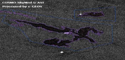

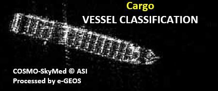
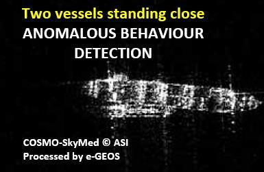
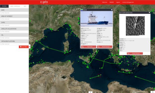

6 Applications Vessel Detection Search And Rescue Intelligence Traffic Monitoring Fisheries inspections Oil Spill Detection Pollution Mapping Environmental Protection Emergency Response Oil Spill
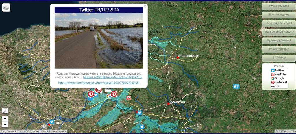
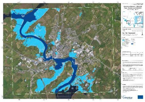
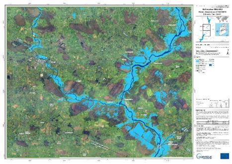
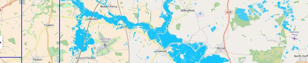
7 FLOOD FLOOD is the e-geos flood awareness platform providing a synoptic view and access to flood related information derived from satellite and other data. FLOOD is designed to exploit heterogeneous data to build flood integrated picture such as: observed flood from a virtual constellation of satellites, exploiting both systematic (e.g. Sentinel-1) and non systematic (e.g. COSMO-SkyMed) acquisition missions observed flood from social media data sources (e.g. Twitter, Instagram, ) exposure and impact information derived from heterogeneous open source database metereological data for Early Warning FLOOD provides flood information services both on a routine (e.g. systematic monitoring) and on an on demand (e.g. rapid mapping on flood hot spots) basis


8 FLOOD: Product Overview Multi-sensor data ingestion Automatic data processing and feature extraction Easy access to flood integrated services e-geos assets Matera Space Center and the GeoStations Network allows global and fast data access Proprietary algorithms for feature detection and recognition Optimized interfaces for data access and public API


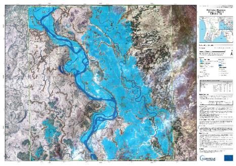
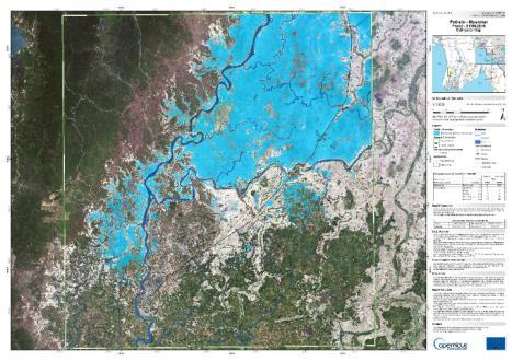
9 Provided Content Flood extent Asset mapping Geospatial Statistical Analysis Alert Notifications 79 km2 Measured 12,00% 10,00% 8,00% 6,00% 4,00% 2,00% 0,00% 11 Urban fabric 20,00% 21 Arable land 15,00% 31 Forests 5,00% 4,00% 12 Industrial, 15,00% 22 Permanent 10,00% 32 commercial crops 3,00% 10,00% Herbaceous 13 Construction 23 Pastures 2,00% sites 5,00% vegetation 5,00% 33 No 14 Vegetated 24 Other 1,00% vegetation areas 0,00% agricultural areas 0,00% 0,00% Urban 1 Areas Agricultural 1 Areas Vegetated 1 Areas 41 Inland wetlands 42 Maritime wetlands 51 Inland waters 52 Marine waters Water 1 Areas Industrial Residential Commercial Recreational Others 13 25% 15% 60% Local Secondary Primary Estimated Buildings 181 Estimated Linear Km of Streets 6 Estimeted Points of Interests Big Industries Nuclear Plants Power Plants Istitutional Sites Hospital Airports Others Estimated Affected Population Strength points Multisensor solution Validated by Institutional User High revisit time And minimum information adge Operational h24/7 Wide and Global coverage
10 Applications Flood Detection Impact assessment Economic Loss assessment Emergency Response Risk assessment

11 All COSMO-SkyMed images ASI - Agenzia Spaziale Italiana e-geos S.p.A L.O. Contrada Terlecchie snc Matera / HQ Via Tiburtina, 965 Roma
DUAL-POLARIZED COSMO SKYMED SAR DATA TO OBSERVE METALLIC TARGETS AT SEA
 DUAL-POLARIZED COSMO SKYMED SAR DATA TO OBSERVE METALLIC TARGETS AT SEA F. Nunziata, M. Montuori and M. Migliaccio Università degli Studi di Napoli Parthenope Dipartimento per le Tecnologie Centro Direzionale,
Copernicus Today and Tomorrow GEO Week Group on Earth Observation Geneva, 16 January 2014 The Copernicus Space Infrastructure
 Copernicus Today and Tomorrow GEO Week Group on Earth Observation Geneva, 16 January 2014 The Copernicus Space Infrastructure Thomas Beer, Policy Coordinator, Copernicus Space Office, ESA-ESRIN, Frascati
National Satellite Data Centre and Finnish Sentinel Collaborative Ground Segment. Jyri Heilimo Finnish Meteorological Instute
 National Satellite Data Centre and Finnish Sentinel Collaborative Ground Segment Jyri Heilimo Finnish Meteorological Instute Sodankylä National Satellite Data Centre National satellite data centre providing
Spanish national plan for land observation: new collaborative production system in Europe
 ADVANCE UNEDITED VERSION UNITED NATIONS E/CONF.103/5/Add.1 Economic and Social Affairs 9 July 2013 Tenth United Nations Regional Cartographic Conference for the Americas New York, 19-23, August 2013 Item
Marine Situational Awareness and Environmental Monitoring using Satellites
 1 The Ny-ålesund Symposium 2013 The Changing Arctic Opportunity or Threat Marine Situational Awareness and Environmental Monitoring using Satellites Rolf Skatteboe President, Kongsberg Satellite Services
Emergency Management Service (EMS) mapping
 mapping") GMES Emergency Management Service (EMS) mapping Frédéric BASTIDE GMES unit, European Commission UN-SPIDER Expert Meeting: "Crowdsource Mapping for Disaster Risk Management and Emergency Response" 3-5 December,
GMES Emergency Management Service (EMS) mapping Frédéric BASTIDE GMES unit, European Commission UN-SPIDER Expert Meeting: "Crowdsource Mapping for Disaster Risk Management and Emergency Response" 3-5 December,
Using COSMO-SkyMed images to improve river flood monitoring and forecasting.
 Using COSMO-SkyMed images to improve river flood monitoring and forecasting. D.C. Mason 1, S.L. Dance 23, J. Garcia-Pintado 24, S. Vetra-Carvalho 2, H.L. Cloke 125, P.D. Bates 6 1 Department of Geography
Sentinel-1 Mission Status
 Sentinel-1 Mission Status Pierre Potin, Sentinel-1 Mission Manager, ESA Luca Martino, Technical Support Engineer, ESA... and the Sentinel-1 operations team PSTG SAR Coordination Working Group 14 December
Copernicus Overview and Emergency Management Service
 Copernicus Overview and Emergency Management Service Frédéric BASTIDE European Commission Open informal session of the United Nations Inter-Agency Meeting on Outer Space Activities 12 March 2013, Geneva
Time and resolution : COSMO-SkyMed VHR data in support to precision farming applications
 17 th GEOCAP Conference Geomatics in Support of the CAP Tallinn, 24 November 2011 Time and resolution : COSMO-SkyMed VHR data in support to precision farming applications e-geos Headquarter Contrada Terlecchie
A Broad View of Geospatial Technology & Systems
 A Broad View of Geospatial Technology & Systems Pete Large Vice President, Trimble On the shoulders of giants 1 Since their time, our ability to generate geospatial information has grown exponentially
WMO Guide on Integrated Urban Weather, Environment and Climate Services for Cities (IUWECS) Hong Kong- an experience from a high-density city
 Hong Kong- an experience from a high-density city") WMO Guide on Integrated Urban Weather, Environment and Climate Services for Cities (IUWECS) Hong Kong- an experience from a high-density city Dr. Chao REN Associate Professor School of Architecture The
WMO Guide on Integrated Urban Weather, Environment and Climate Services for Cities (IUWECS) Hong Kong- an experience from a high-density city Dr. Chao REN Associate Professor School of Architecture The
CopernicusEU. the EU's Earth Observation Programme. Sara Zennaro Atre Delegation of the European Union to Japan
 Copernicus the EU's Earth Observation Programme Sara Zennaro Atre Delegation of the European Union to Japan Status Overview, Sept 2016 & Ocean Policies Seminar 4 October 2016 ollow us on: Copernicus EU
Green Space Services for Local Monitoring
 Green Space Services for Local Monitoring Aratos Group V3.0 2016/08 Value added services for the society using space and satellite technologies Aratos Group 2 One of the first European downstream value
Copernicus Overview. Major Emergency Management Conference Athlone 2017
 Copernicus Overview Major Emergency Management Conference Athlone 2017 Copernicus is a European programme implemented by the European Commission. The services address six thematic areas: land, marine,
Land Cover Classification Mapping & its uses for Planning
 Land Cover Classification Mapping & its uses for Planning What is Land Cover Classification Mapping? Examples of an actual product Why use Land Cover Classification Mapping for planning? Possible uses
European Space Agency
 Guidelines - Guidelines how/when to interact during the WebEx session: - Due to the number of attendees, please keep always your webcam and microphone switched-off - You can use anytime the chat to all
Earth Observation Satellites Dawn of Application Specific Satellite Data. Date: 26 July 2017
 Earth Observation Satellites Dawn of Application Specific Satellite Data Date: 26 July 2017 Introducing a World of New Possibilities Satellite imagery is a critical fountain of information on al levels
Copernicus Data Driven Services for Regional & Local Government in Greece
 Workshop on Copernicus uptake by public authorities Gabriel Mavrellis CEO, Geospatial Enabling Technologies Copernicus Data Driven Services for Regional & Local Government in Greece The Company Copernicus
The platform is the means, not the end goal
 The platform is the means, not the end goal + Complete analytics platform at an accessible price point Compliments existing workflows by integrating with the new intelligent farm equipment. The goal is
Building Institutional Capacity for Multi-Hazard Early Warning in Pacific Countries Subtitle
 Building Institutional Capacity for Multi-Hazard Early Warning in Pacific Countries Subtitle Title Keran Wang Chief, Space Applications Section ICT and Disaster Risk Reduction Division 30 March 2018 Slide
Building Institutional Capacity for Multi-Hazard Early Warning in Asia and the Pacific Subtitle
 Building Institutional Capacity for Multi-Hazard Early Warning in Asia and the Pacific Subtitle Title Keran Wang Chief, Space Applications Section ICT and Disaster Risk Reduction Division 22 May 2018 Pillar
Norwegian spatial data infrastructure supporting disaster risk management Norwegian Mapping Authority
 Norwegian spatial data infrastructure supporting disaster risk management Norwegian Mapping Authority Arvid Lillethun, Norwegian Mapping Authority Land and Poverty 2018 Conference, World Bank 19.-23. March
Let's Make Our Cities Breathable BECAUSE CLEAN AIR BELONGS TO EVERYONE.
 Let's Make Our Cities Breathable BECAUSE CLEAN AIR BELONGS TO EVERYONE. Clean Air is a Human Right that Everyone Should be Entitled to Making cities more breathable starts by measuring, analyzing and understanding
Geographic Information Infrastructure and Policy Framework for Sustainable Mountain Development in the Hindu Kush-Himalayas
 Geo SMART ASIA 2017 22-24 August, Kualalampur Geographic Information Infrastructure and Policy Framework for Sustainable Mountain Development in the Hindu Kush-Himalayas Basanta Shrestha, Director Strategic
E x a m p l e s o f t o o l s f o r s e a s i t u a t i o n a l a w a r e n e s s u s i n g C M E M S d a t a. Copernicus EU
 E x a m p l e s o f t o o l s f o r s e a s i t u a t i o n a l a w a r e n e s s u s i n g C M E M S d a t a Copernicus EU Copernicus EU Copernicus EU www.copernicus.eu S e a S i t u a t i o n a l A w
Primary author: Tymvios, Filippos (CMS - Cyprus Meteorological Service, Dpt. of Aeronautical Meteorology),
,") Primary author: Tymvios, Filippos (CMS - Cyprus Meteorological Service, Dpt. of Aeronautical Meteorology), ftymvios@ms.moa.gov.cy Co-author: Marios Theophilou (Cyprus Meteorological Service, Climatology
Primary author: Tymvios, Filippos (CMS - Cyprus Meteorological Service, Dpt. of Aeronautical Meteorology), ftymvios@ms.moa.gov.cy Co-author: Marios Theophilou (Cyprus Meteorological Service, Climatology
CORINE LAND COVER CROATIA
 CORINE LAND COVER CROATIA INTRO Primary condition in making decisions directed to land cover and natural resources management is presence of knowledge and high quality information about biosphere and its
The known requirements for Arctic climate services
 The known requirements for Arctic climate services based on findings described in STT White paper 8/2015 Johanna Ekman / EC PHORS STT Regional drivers The Arctic region is home to almost four million people
GI Technology for Disaster Management
 GI Technology for Disaster Management 17 th ICC on the Regional Space Applications Programme for Sustainable Development (RESAP) 26 th Nov 2013 Bangkok Thailand Period and time of seasonal in thailand
Exploiting maritime Big Data, the Blue Hub
 Exploiting maritime Big Data, the Blue Hub Marlene Alvarez Alvarez, Michele Vespe, Harm Greidanus Marlene.alvarez@jrc.ec.europa.eu Joint Research Centre the European Commission's in-house science service
Arctic Observing Systems Challenges, New opportunities and Integration
 Arctic Observing Systems Challenges, New opportunities and Integration Japan Norway Arctic Science Week 03 June 2016 By Stein Sandven, NERSC Building an integrated Arctic Observing System Need to collect,
Space for Smarter Government Programme
 Space for Smarter Government Programme Development of Operational National Satellite Imaging Flood Mapping Capability Project Number: 59287-454144 Web: http://www.spaceforsmartergovernment.uk/ Email: ssgp@sa.catapult.org.uk
EuroGEOSS Protected Areas Pilot
 EuroGEOSS Protected Areas Pilot Max Craglia European Commission Joint Research Centre Part 1: the present MyNatura2000 Mobile app. Awareness raising & volunteered data collection. Natura2000 covers 18%
sentinel-2 COLOUR VISION FOR COPERNICUS
 sentinel-2 COLOUR VISION FOR COPERNICUS SATELLITES TO SERVE By providing a set of key information services for a wide range of practical applications, Europe s Copernicus programme is providing a step
Themes for Geomatics Conference. Geodesy Themes
 Themes for Geomatics Conference Geodesy Themes Geodynamics o Modeling the Deformation of the Earth s Crust o Recent Advances in Geometric Approaches to Deformation Analysis o Monitoring Systems (Sensors
Climate Risk Visualization for Adaptation Planning and Emergency Response
 Climate Risk Visualization for Adaptation Planning and Emergency Response NCR Flood Fact Finding Workshop Ricardo Saavedra ricardo@vizonomy.com Social Media, Mobile, and Big Data St. Peter s Basilica,
Space research. Horizon Work Programme. "Countdown to Horizon 2020 Space" Earth Observation topics. Brussels, 12 December 2013
 Space research Horizon 2020 - Work Programme "Countdown to Horizon 2020 Space" Earth Observation topics Brussels, 12 December 2013 richard.gilmore@ec.europa.eu Table of contents FP/Copernicus - general
National Remote Sensing Center of China. Space Technology for Sustainable Development in China Status, Achievements and Futures.
 National Remote Sensing Center of China Space Technology for Sustainable Development in China Status, Achievements and Futures Jing Li National Remote Sensing Center of China Ministry of Science and Technology,
Copernicus Space Component Status & Evolution
 Copernicus Space Component Status & Evolution ESCAP, Bangkok 09 October 2017 Simon Jutz Head of the ESA Copernicus Space Office Directorate of Earth Observation Programmes 28 satellites in development
World Meteorological Organization Working together in weather, climate and water
 WMO World Meteorological Organization Working together in weather, climate and water Strengthening Regional Cooperation to Support Forecasting with Multi-Hazard Approach in RA IV SWFDP concepts and lessons
Time Series Analysis with SAR & Optical Satellite Data
 Time Series Analysis with SAR & Optical Satellite Data Thomas Bahr ESRI European User Conference Thursday October 2015 harris.com Motivation Changes in land surface characteristics mirror a multitude of
ALASKA DEEP-DRAFT ARCTIC PORT EVALUATION
 ALASKA DEEP-DRAFT ARCTIC PORT EVALUATION Joint Study of Federal and State June 20, 2012 Opportunity and Constraint Warming of Arctic region is leading to new maritime opportunities. Thawing of permafrost
Space Applications for Disaster Risk Reduction and Sustainable Development
 Space Applications for Disaster Risk Reduction and Sustainable Development Space Applications Section (SAS) ICT and Disaster Risk Reduction Division (IDD) UNESCAP Contents I. RESAP Activities 2016-2017
The Changing Landscape of Land Administration
 The Changing Landscape of Land Administration B r e n t J o n e s P E, PLS E s r i World s Largest Media Company No Journalists No Content Producers No Photographers World s Largest Hospitality Company
Eyes in the Sky & Data Analysis.
 Eyes in the Sky & Data Analysis How can we collect Information about Earth Climbing up Trees & Mountains Gathering Food Self Protection Understanding Surroundings By Travelling Collected Information Converted
UrtheCast s High Resolution Imagery, HD Video and Synthetic Aperture Radar from Space for Smart Earth Observations Dr. Rao S.
 UrtheCast s High Resolution Imagery, HD Video and Synthetic Aperture Radar from Space for Smart Earth Observations Dr. Rao S. Ramayanam Vice President Middle East, Africa and South Asia Geo Smart Asia
Unique Vaisala Global Lightning Dataset GLD360 TM
 Unique Vaisala Global Lightning Dataset GLD360 TM / THE ONLY LIGHTNING DETECTION NETWORK CAPABLE OF DELIVERING HIGH-QUALITY DATA ANYWHERE IN THE WORLD GLD360 provides high-quality lightning data anywhere
NOAA Surface Weather Program
 NOAA Surface Weather Program Maintenance Decision Support System Stakeholder Meeting #9 Jim O Sullivan NOAA Surface Weather Program Manager NWS Office of Climate, Water, and Weather Services September
Framework Contract for Copernicus Service in Support to EU External Action Geospatial Production
 Framework Contract for Copernicus Service in Support to EU External Action Geospatial Production ANNEX E to the Tender Specifications SEA Portfolio Invitation to tender SATCEN-OP-01/17 Page 1 of 11 1.
Smart use of Geographic Information System (GIS) platform for delivering weather information and nowcasting services
 platform for delivering weather information and nowcasting services") Smart use of Geographic Information System (GIS) platform for delivering weather information and nowcasting services C. K. Pan Hong Kong Observatory Hong Kong, China It is a world of beauty Source: Image
Smart use of Geographic Information System (GIS) platform for delivering weather information and nowcasting services C. K. Pan Hong Kong Observatory Hong Kong, China It is a world of beauty Source: Image
AND THE COOPERATION WITH SENTINEL ASIA FOR DISASTER MANAGEMENT
 Ministry of Natural resources and Environment National Remote Sensing DEpartment NATIONAL REMOTE SENSING DEPARTMENT (NRSD) AND THE COOPERATION WITH SENTINEL ASIA FOR DISASTER MANAGEMENT By: Dr. Chu Hai
International Conference Analysis and Management of Changing Risks for Natural Hazards November 2014 l Padua, Italy
 Abstract Code: B01 Assets mapping products in support of preparedness and prevention measures (examples from Germany, Italy and France) Marc Mueller, Thierry Fourty, Mehdi Lefeuvre Airbus Defence and Space,
IAEG SDGs WG GI, , Mexico City
 IAEG SDGs WG GI, 12-14.12.2016, Mexico City UN-GGIM:Europe s perspective and activities to support better integration of geospatial information and statistics and the UN SDG monitoring Pier-Giorgio Zaccheddu,
Compact guides GISCO. Geographic information system of the Commission
 Compact guides GISCO Geographic information system of the Commission What is GISCO? GISCO, the Geographic Information System of the COmmission, is a permanent service of Eurostat that fulfils the requirements
Sentinel-1 Mission Status
 Sentinel-1 Mission Status Pierre Potin, Sentinel-1 Mission Manager 5TH GEOGLAM RAPP Workshop 16-17 May 2017, ESRIN Sentinel-1: Copernicus radar imaging mission for ocean, land, emergency Part of the Copernicus
SDI and Beyond The Importance of Standards and Interoperability For Good Governance; Selected Examples
 SDI and Beyond The Importance of Standards and Interoperability For Good Governance; Selected Examples Trevor Taylor, Director, Member Services, Asia and the Americas Sao Paulo May 7 th, 2014 Why is Geospatial
State of Israel Ministry of Housing and Construction Survey of Israel. The Hydrological project case
 State of Israel Ministry of Housing and Construction Survey of Israel The Hydrological project case Survey of Israel Content Introduction To the Survey of Israel The operation assumptions The main responsibilities
Preliminary assessment of socio-economic benefits from CMA Meteorological Satellite Programmes. Dr. ZHENG Guoguang / YANG Jun
 Preliminary assessment of socio-economic benefits from CMA Meteorological Satellite Programmes Dr. ZHENG Guoguang / YANG Jun China Meteorological Administration CMA report to CM-12 WMO HQ, June 21, 2014
June 19 Huntsville, Alabama 1
 June 19 Huntsville, Alabama 1 Real-Time Geospatial Data: The Fusion of PI and ArcGIS Enabling Smarter Facilities Management OSIsoft and Esri Mapping and Location Analytics Platform Supporting Your Use
Remote sensing data uses and supply in Vietnam. Dr. Chu Hải Tùng National Remote Sensing Department, Ministry of Natural Resource and Environment
 Remote sensing data uses and supply in Vietnam Dr. Chu Hải Tùng National Remote Sensing Department, Ministry of Natural Resource and Environment Content Uses of remote sensing data in Vietnam Roles of
FOURTH INTERNATIONAL PORT METEOROLOGICAL OFFICERS WORKSHOP AND SUPPORT TO GLOBAL OCEAN OBSERVATIONS USING SHIP LOGISTICS
 FOURTH INTERNATIONAL PORT METEOROLOGICAL OFFICERS WORKSHOP AND SUPPORT TO GLOBAL OCEAN OBSERVATIONS USING SHIP LOGISTICS PMO-IV 8-10 DEC 2010, ORLANDO, FLORIDA, USA 1 This presentation is generally for
Oman NSDI Supporting Economic Development. Saud Al-Nofli Director of Spatial Data Directorate General of NSDI, NCSI
 Oman NSDI Supporting Economic Development 2017 Saud Al-Nofli Director of Spatial Data Directorate General of NSDI, NCSI "It s critical to make correct decisions the first time to optimize the Investments
U s i n g t h e E S A / E U M E T C A S T N a v i g a t o r s
 U s i n g t h e E S A / E U M E T C A S T N a v i g a t o r s Copernicus User Uptake Information Sessions Copernicus EU Copernicus EU Copernicus EU www.copernicus.eu I N T R O D U C T I O N O F U S E C
CIVIL PROTECTION AND SAFE SKY
 CIVIL PROTECTION AND SAFE SKY DURING THE SPACE VEHICLES REENTRY DeCAS PATENTED An alert system for the safety of people and things on the Earth s surface and for the safety of aircraft and space vehicles
SUPPORTS SUSTAINABLE GROWTH
 DDSS BBUUN NDDLLEE G E O S P AT I A L G O V E R N A N C E P A C K A G E SUPPORTS SUSTAINABLE GROWTH www.digitalglobe.com BRISBANE, AUSTRALIA WORLDVIEW-3 30 CM International Civil Government Programs US
NCTCOG Regional GIS Meeting 6-Years and Going Strong. May 15, 2018 hosted by: Tarrant County
 NCTCOG Regional GIS Meeting 6-Years and Going Strong May 15, 2018 hosted by: Tarrant County Woolpert at a Glance 1911 Founded in Dayton, Ohio 25+ Offices across the nation 800+ Global employees 25+ OFFICES
A BRIEF INTRODUCTION TO COPERNICUS AND CAMS
 A BRIEF INTRODUCTION TO COPERNICUS AND CAMS Juan Garcés de Marcilla Director of Copernicus Services European Centre for Medium-Range Weather Forecasts Copernicus EU Copernicus EU Copernicus EU www.copernicus.eu
Supporting GPSC Cities with Satellite Earth Observation for Sustainable Urban Development
 Supporting GPSC Cities with Satellite Earth Observation for Sustainable Urban Development Global Platform for Sustainable Cities African Regional Workshop 14 May 2018 AfDB Headquarters Abidjan, Côte d'ivoire
C O P E R N I C U S F O R G I P R O F E S S I O N A L S
 C O P E R N I C U S F O R G I P R O F E S S I O N A L S Downstream Applications MALTA 2017-06-26 Pascal Lory, EUROGI EU EU EU www.copernicus.eu S c o p e Identifying urban housing density: Stella Ofori-Ampofo,
Environmental Response Management Application
 Environmental Response Management Application Coastal Response Research Center Nancy Kinner, Michele Jacobi, Rob Braswell, Kurt Schwehr & Amy Merten RRT III May 14, 2008 1 Talk Outline Overview of Center
Copernicus Schaffung einer europäischen Kapazität für die operationelle Erdbeobachtung
 Copernicus Schaffung einer europäischen Kapazität für die operationelle Erdbeobachtung ESOC, Darmstadt, 23 April 2015 Simon Jutz, ESA Head, Copernicus Space Office (EOP-CO) Earth Observation Programmes
STATE GEOGRAPHIC INFORMATION DATABASE
 STATE GEOGRAPHIC INFORMATION DATABASE Data Information and Knowledge Management STATE GEOGRAPHIC INFORMATION DATABASE EXECUTIVE SUMMARY Utah has developed one of the most comprehensive statewide GIS resources
CLICK HERE TO KNOW MORE
 CLICK HERE TO KNOW MORE UrtheCast Constellations: World s first fully-integrated Optical and SAR constellations Fabrizio Pirondini, CEO Deimos Imaging & GM Earth Observation UrtheCast Geospatial World
L i n k i n g f l o o d i m p a c t f o r e c a s t i n g a n d s a t e l l i t e r a p i d m a p p i n g i n E u r o p e
 L i n k i n g f l o o d i m p a c t f o r e c a s t i n g a n d s a t e l l i t e r a p i d m a p p i n g i n E u r o p e Francesco Dottori, Milan Kalas, Peter Salamon, Annett Wania, Ines Rivero (EC JRC)
Earth Observation and GEOSS in Horizon Copernicus for Raw Material Workshop 5 th September 2016
 Earth Observation and GEOSS in Horizon 2020 Copernicus for Raw Material Workshop 5 th September 2016 Gilles OLLIER Head of Sector -Earth observation Directorate Environment Unit I.4 Climate Actions and
The ESA Earth observation programmes overview and outlook
 The ESA Earth observation programmes overview and outlook Dr. Volker Liebig Director, ESA EO Programmes ILA 2008, Berlin ENVISAT mission: 6 years! Bam earthquake Tectonic uplift (Andaman) Arctic 2007 First
DANIEL WILSON AND BEN CONKLIN. Integrating AI with Foundation Intelligence for Actionable Intelligence
 DANIEL WILSON AND BEN CONKLIN Integrating AI with Foundation Intelligence for Actionable Intelligence INTEGRATING AI WITH FOUNDATION INTELLIGENCE FOR ACTIONABLE INTELLIGENCE in an arms race for artificial
THE COPERNICUS PROGRAMME
 THE COPERNICUS PROGRAMME Jolyon Martin, Sentinel Data Access Manager & Sentinel-5P Operations Manager, ESA Pierre Potin, Sentinel-1 Mission Manager, ESA Earth Observation Showcase Emerging Applications
UN COPUOS 52 nd session of the Scientific and Technical Subcommittee. COPERNICUS - an European Achievement. S. Jutz Head, ESA Copernicus Space Office
 UN COPUOS 52 nd session of the Scientific and Technical Subcommittee COPERNICUS - an European Achievement S. Jutz Head, ESA Copernicus Space Office 11 Feb 2015, Vienna 1 2 What is Copernicus? European
Standardization of the land cover classes using FAO Land Cover Classification System (LCCS)
") Sofia, 17-18 September 2008, LPIS Workshop LPIS applications and quality 1 Standardization of the land cover classes using FAO Land Cover Classification System (LCCS) Pavel MILENOV Agriculture Unit, JRC
Sofia, 17-18 September 2008, LPIS Workshop LPIS applications and quality 1 Standardization of the land cover classes using FAO Land Cover Classification System (LCCS) Pavel MILENOV Agriculture Unit, JRC
Key Points Sharing fosters participation and collaboration Metadata has a big role in sharing Sharing is not always easy
 Sharing Resources Geoff Mortson esri, Inc. SDI Solutions Team Key Points Sharing fosters participation and collaboration Metadata has a big role in sharing Sharing is not always easy Data Sharing is Good
Opportunities for advanced Remote Sensing; an outsider s perspective
 Opportunities for advanced Remote Sensing; an outsider s perspective Ramon Hanssen Delft University of Technology 1 Starting questions Can we do more with the data we are already acquire? What s in stock
Applied Geoscience and Technology Division SOPAC. Joy Papao, Risk Information Systems Officer
 Joy Papao, Risk Information Systems Officer Secretariat of the Pacific Community SPC 22 Pacific Island States Head office in Noumea, New Caledonia 2 Regional offices (Pohnpei and Honiara) 600 staff 9 Technical
sentinel-3 A BIGGER PICTURE FOR COPERNICUS
 sentinel-3 A BIGGER PICTURE FOR COPERNICUS SATELLITES TO SERVE By providing a set of key information services for a wide range of practical applications, Europe s Copernicus programme has been put in place
Flood inundation data assimilation and big data
 Flood inundation data assimilation and big data Sanita Vetra-Carvalho Sarah L. Dance David Mason Javier Garcia-Pintado University of Reading 22nd February 2017 S. Vetra-Carvalho, S. L. Dance WP1 22nd February
Discovery and Access of Geospatial Resources using the Geoportal Extension. Marten Hogeweg Geoportal Extension Product Manager
 Discovery and Access of Geospatial Resources using the Geoportal Extension Marten Hogeweg Geoportal Extension Product Manager DISCOVERY AND ACCESS USING THE GEOPORTAL EXTENSION Geospatial Data Is Very
National Geographic Institute (IGN)
") (IGN) National Centre of Geographic Information (CNIG) Tenth United Nations Regional Cartographic Conference of the Americas New York, 19-23 August 2013 Spanish National Land Observation Program (PNOT)
(IGN) National Centre of Geographic Information (CNIG) Tenth United Nations Regional Cartographic Conference of the Americas New York, 19-23 August 2013 Spanish National Land Observation Program (PNOT)
Fugro Geospatial: Turning Spatial Data into Knowledge
 Fugro Geospatial: Turning Spatial Data into Knowledge 2016 Fugro Geospatial, GIS and Consultants Locations Variety of Collection Platforms Traditional Mapping Traditional Mapping Imagery Photogrammetric
New NASA Ocean Observations and Coastal Applications
 New NASA Ocean Observations and Coastal Applications Duane Armstrong Chief, Applied Science & Technology Project Office August 20, 2014 1 Outline NASA s new Earth Science Ocean Science Missions for 2014
Geo-information and Disaster Risk Reduction in the Hindu Kush-Himalayan region
 Geo-information and Disaster Risk Reduction in the Hindu Kush-Himalayan region Basanta Shrestha, Division Head MENRIS, International Centre for Integrated Mountain Development Kathmandu, Nepal The International
«Data management and visualization issues of the Copernicus satellite data»
 «Data management and visualization issues of the Copernicus satellite data» Dr. Panos Lolonis Member of the Scientific Council NATIONAL CADASTRE AND MAPPING AGENCY S.A. 288 Mesogion Ave 155 62 Holaros
STAMP Spa)al Tools for Arc)c Mapping & Planning. Creating an interactive data tool to improve access and usability of Arctic data
al Tools for Arc)c Mapping & Planning. Creating an interactive data tool to improve access and usability of Arctic data") STAMP Spa)al Tools for Arc)c Mapping & Planning Creating an interactive data tool to improve access and usability of Arctic data Mission Provide easy access to physical, chemical, and biological data Network
STAMP Spa)al Tools for Arc)c Mapping & Planning Creating an interactive data tool to improve access and usability of Arctic data Mission Provide easy access to physical, chemical, and biological data Network
Remote Sensing for Sea Surface Monitoring. Cristina Bentz PETROBRAS R&D Center Environment Assessment and Monitoring
 Remote Sensing for Sea Surface Monitoring Cristina Bentz PETROBRAS R&D Center Environment Assessment and Monitoring cris@petrobras.com.br Overview Introduction Orbital sea surface monitoring: Scope and
An Extended Enterprise Architecture for a Network- Enabled, Effects-based Approach for National Park Protection Transitioning Military Paradigms
 An Extended Enterprise Architecture for a Network- Enabled, Effects-based Approach for National Park Protection Transitioning Military Paradigms Tod M. Schuck Stevens Institute of Technology Lockheed Martin
Effective Utilization of Synthetic Aperture Radar (SAR) Imagery in Rapid Damage Assessment
 Imagery in Rapid Damage Assessment") Effective Utilization of Synthetic Aperture Radar (SAR) Imagery in Rapid Damage Assessment Case Study Pakistan Floods SUPARCO M. Maisam Raza, Ahmad H. Rabbani SEQUENCE Flood Monitoring using Satellite
Effective Utilization of Synthetic Aperture Radar (SAR) Imagery in Rapid Damage Assessment Case Study Pakistan Floods SUPARCO M. Maisam Raza, Ahmad H. Rabbani SEQUENCE Flood Monitoring using Satellite
Evaluation of land surface temperature (LST) patterns in the urban agglomeration of Krakow using different satellite data and GIS
 patterns in the urban agglomeration of Krakow using different satellite data and GIS") Evaluation of land surface temperature (LST) patterns in the urban agglomeration of Krakow using different satellite data and GIS Jakub P. Walawender 1,2 1 Satellite Remote Sensing Centre, Institute of
Evaluation of land surface temperature (LST) patterns in the urban agglomeration of Krakow using different satellite data and GIS Jakub P. Walawender 1,2 1 Satellite Remote Sensing Centre, Institute of
PUBLIC SAFETY POWER SHUTOFF POLICIES AND PROCEDURES
 PACIFIC GAS AND ELECTRIC COMPANY PUBLIC SAFETY POWER SHUTOFF POLICIES AND PROCEDURES SEPTEMBER 2018 1 PACIFIC GAS AND ELECTRIC COMPANY PUBLIC SAFETY POWER SHUTOFF POLICIES AND PROCEDURES SEPTEMBER 2018
Chantale Bijoux Meteorological Officer
 Chantale Bijoux Meteorological Officer Introduction The Seychelles s National Meteorological Services plays a vital role in providing weather and climate information including severe weather changes, therefore
13 th EUMETSAT User Forum in Africa
 13 th EUMETSAT User Forum in Africa GMES & Africa implementation in Western Africa Dogbeda M.Y. Azumah Regional Marine Centre University of Ghana Pictures zone UG GMES Presentation Layout UG G Project