Weather Needs for UAS Operations
|
|
|
- Belinda Banks
- 5 years ago
- Views:
Transcription
1 Minneapolis - Denver - Washington, D.C. Weather Needs for UAS Operations Brian Haynes - President November
2 Sensurion Background: 10-year company history UAS Weather Needs Sensurion Perspective Extensive manned aircraft experience Extensive weather experience Worked with NASA and NCAR in many areas, for many years Extensive UAS Experience We understand how hard it is to operate aircraft safely and reliably and yet profitably and what it takes to do that, and how the manned aviation industry achieved those goals. The UAS industry still has a long way to go in all three of those areas, and can learn a lot from the manned aviation industry but also has specialized needs that are very different.
3 Sensurion Background: UAS Weather Needs Sensurion Perspective Airline weather requirements, systems, & solutions GA weather & flight planning systems R&D, deployment and long-term ops of national systems Preflight & in-flight Dissemination and Collection Systems R&D TAMDAR, MDCARS, etc. Weather Radar Systems Weather uplink, downlink, and cockpit displays Turbulence, Icing, Winds, Deicing We can take advantage of experience in traditional weather & aviation, but must also avoid default thinking
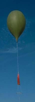
4 Typical suas Aircraft TYPICAL Fixed-Wing suas: Conventional Fixed Wing Design Hand, rail, or gear takeoff Flight durations mins Multiple Payload options Working toward BLOS 0-60 kts, stall speeds 10 kts 20 kt max l/d Full autoflight avionics Variety of recovery systems TYPICAL Multirotor suas Ease of launch and flight Flight duration <15-45 min Visual/EO sensors 0-20 kts speed Strong reliance on GPS Manual & Limited Autoflight Sensurion Sentinel also has tethered configuration Sensurion Magpie MP-1 Sensurion MP-4
5 How is Weather Relevant to suas Operations? Planning Can I successfully conduct the mission? Safely? Can I stay within required altitude, geofencing, and other limits for entire mission? Can I successfully recover aircraft at the end of the mission period? What impact will weather have on my mission duration capability? Direct Operational Impacts Scheduling jobs, personnel, and logistics Managing challenging or near-limit conditions Reacting to changing conditions Contributing Data Back Into the Weather System Alert other operators of changing conditions TAMDAR-type observation input to forecast models
6 Weather Impacts on Practical suas Operations Scale Factors of suas vs Part 23 Aircraft Make Them Much More Susceptible to Turbulence and Wind Shear: Wing loading is much lower Mass is much lower Wing/Rotor Spans are Much Shorter Stall and cruise speeds much lower than Part 23 and Part 25 winds have a dramatically increased impact Very compressed range of V Speeds Cruise speeds top out about where Part 23 begins Approach speeds 8-10 Kts Many lower boundary wind speeds can exceed forward flight speeds thus creating a no-return scenario Many suas have Precipitation Restrictions
7 Weather Impacts on Practical suas Operations Most suas are not intended for flight into IMC Icing, precip, loss of Vis/CAVOK all potential issues Ability to maintain VLOS is key to planning and executing many missions How do we characterize ground-to-air visibility Effects of weather on ground-based (versus aircraft-based) operators themselves Temperature effects on Li-Ion battery packs Effects of turbulence & winds on mission duration Deviation limits and stabilization energy cost can significantly impact mission duration Increasing levels of suas autonomy will require reduced weather uncertainty
8 So What Weather Information Will Be Needed - Specifically? Currently available WX information, tailored for suas users New products that provide much higher spatial and temporal resolution in the boundary layer area, including: Winds, Turbulence and Gustiness Factors We need to look at Gusts differently than classical turbulence in low-altitude, suas Ops contexts Indexing Gusts/Turbulence to a radically different scale of airframe/limits Visibility referenced to VLOS-type operations Envelope Protection: Probability of exceeding specific limit factors including: Max Winds versus aircraft return speeds Gusts, Turbulence, Shear Controllability AND Battery Life Temperature & Density Altitude Visibility variations Precipitation / Icing Variations in altimeter setting during a mission Lightning/Static Buildup
9 So What Weather Information Will Be Needed - Specifically? BLOS Weather Needs Downrange landing and diversion site forecasts / nowcasts Long-duration operation forecasts / nowcasts Corridor-oriented products Tethered operations Very long duration operations Electrical considerations e.g., static and lightning
10 Weather Sources for suas Will there be a single authoritative source for weather data and translated data for operators? o Yes and No FAA Will always be a source of regulatory requirements Sheer volume of operations & pace of industry/technology growth/change and low per-ops capital value will make it very hard for government to take on primary source role Government is more likely to define trade space, and pedigree/reporting requirements Industry may be better positioned to fill the high-volume, low-cost, rapidly evolving direct service needs INSURERS may be a critical part of defining and approving WX and other safety-assurance components of this industry
11 Weather Sources for suas Leverage the UAS platforms themselves as a key part of the solution Flight stabilization / control systems inherently have turbulence and other atmospheric data Real-time observations of boundary layer conditions Nowcasting Research & modeling Calibrate model metrics for individual aircraft types Interaction between turbulence, deviation limits/range, and vehicle performance Terrain and vegetation database updates


12 UAVs as a Weather-Collection Platform Micro AMDAR/TAMDAR/MDCRS Sensurion MP-1 or MP-4


13 Thank you! th Ave South Minneapolis, MN
Weather Considerations for UAS Integration
 Weather Considerations for UAS Integration Scot Campbell 8 December 2016 Sponsor: Steve Abelman, ANG-C6 DISTRIBUTION STATEMENT A. Approved for public release: distribution unlimited. Legal Notices This
Complementary Use of Airborne Wx Radar & Datalink Graphical Wx
 Complementary Use of Airborne Wx Radar & Datalink Graphical Wx What if to What next? Cheri Haynes XCELAR Friends/Partners in Aviation Weather Forum October 31, 2012 What if to What next? Today there are
Advances in Weather Technology
 Advances in Weather Technology Dr. G. Brant Foote National Center for Atmospheric Research 16 May 2001 NCAR Research Results in Aviation Weather Built on the foundation of the nation s long-standing investment
Weather in the Connected Cockpit
 Weather in the Connected Cockpit What if the Cockpit is on the Ground? The Weather Story for UAS Friends and Partners of Aviation Weather November 2, 2016 Chris Brinton brinton@mosaicatm.com Outline Mosaic
NCAR UCAR. 50 th Anniversary Lecture
 NCAR & UCAR 50 th Anniversary Lecture Turbulence, Wind Shear, Toxin Attacks, and Other Things That Go Bump In the Night: Applied Research for Real-Life Problems Bill Mahoney National Center for Atmospheric
Advances in weather and climate science
 Advances in weather and climate science Second ICAO Global Air Navigation Industry Symposium (GANIS/2) 11 to 13 December 2017, Montreal, Canada GREG BROCK Scientific Officer Aeronautical Meteorology Division
14.2 Weather impacts and routing services in support of airspace management operations. David I. Knapp, Jeffrey O. Johnson, David P.
 14.2 Weather impacts and routing services in support of airspace management operations David I. Knapp, Jeffrey O. Johnson, David P. Sauter U.S. Army Research Laboratory, Battlefield Environment Division,
Technical Description for Aventus NowCast & AIR Service Line
 Technical Description for Aventus NowCast & AIR Service Line This document has been assembled as a question and answer sheet for the technical aspects of the Aventus NowCast Service. It is designed to
LANDMARK TM. Class B TAWS
 LANDMARK TM Class B TAWS WAAS-GPS Accurate - 320 Mile Range - Easily Integrated Introducing the LandMark Model 8100 LandMark is the first stand-alone Class B TAWS to offer an optional WAAS-GPS sensor.
Guidance on Aeronautical Meteorological Observer Competency Standards
 Guidance on Aeronautical Meteorological Observer Competency Standards The following guidance is supplementary to the AMP competency Standards endorsed by Cg-16 in Geneva in May 2011. Format of the Descriptions
Technical Description for Aventus NowCast & AIR Service Line
 Technical Description for Aventus NowCast & AIR Service Line This document has been assembled as a question and answer sheet for the technical aspects of the Aventus NowCast Service. It is designed to
Implementation Guidance of Aeronautical Meteorological Observer Competency Standards
 Implementation Guidance of Aeronautical Meteorological Observer Competency Standards The following guidance is supplementary to the AMP competency Standards endorsed by Cg-16 in Geneva in May 2011. Please
Automated in-situ Turbulence reports from Airbus aircraft. Axel PIROTH
 Automated in-situ Turbulence reports from Airbus aircraft Axel PIROTH Context & Background Atmospheric Turbulence is leading to situations somewhat uncomfortable... Page 2 Cost of Turbulence for Air Carriers
Recap of the NTSB PIREP Forum: Optimizing Safety Benefits for Pilots, ATC, and Meteorologists. Paul Suffern NTSB Meteorologist
 Recap of the NTSB PIREP Forum: Optimizing Safety Benefits for Pilots, ATC, and Meteorologists Paul Suffern NTSB Meteorologist 1 2 Wx Accident Trend 3 Preflight Planning TAF KRDU 162340Z 1700/1724 28003KT
Reprint 797. Development of a Thunderstorm. P.W. Li
 Reprint 797 Development of a Thunderstorm Nowcasting System in Support of Air Traffic Management P.W. Li AMS Aviation, Range, Aerospace Meteorology Special Symposium on Weather-Air Traffic Management Integration,
Global UAV-based solutions for the industry and agriculture.
 Global UAV-based solutions for the industry and agriculture. Remote sensing of vegetation from drones (UAS). The example of the Trimble Unmanned Aerial Solution Emmanuel de Maistre, co-founder & CEO demaistre@redbird.fr
Multi-Function Display Pilot s Guide Addendum
 Multi-Function Display Pilot s Guide Addendum Software Release 4.2 or Later 600-00344-000 Rev: 01-1- EX500/EX600 Document Revision History Date Revision Description February 21, 2018 00 Initial Release
Montréal, 7 to 18 July 2014
 INTERNATIONAL CIVIL AVIATION ORGANIZATION WORLD METEOROLOGICAL ORGANIZATION 6/5/14 Meteorology (MET) Divisional Meeting (2014) Commission for Aeronautical Meteorology Fifteenth Session Montréal, 7 to 18
AIR TRAFFIC MANAGEMENT DECISION SUPPORT USING INTEGRATED METHODS OF DIAGNOSING AND FORECASTING AVIATION WEATHER
 AIR TRAFFIC MANAGEMENT DECISION SUPPORT USING INTEGRATED METHODS OF DIAGNOSING AND FORECASTING AVIATION WEATHER Tenny A. Lindholm, The National Center for Atmospheric Research, Boulder, Colorado, USA Abstract
Dr. Ananthakrishna Sarma, Senior Scientist, SAIC, 1710 SAIC Dr., McLean, VA 22102
 Dr. Ananthakrishna Sarma, Senior Scientist, SAIC, 1710 SAIC Dr., McLean, VA 22102 Presented at the Airships to the Arctic Conference of the Van Horne Institute 5-6 December 2011 Introduction Weather hazards
Federal Aviation Administration
 High Ice Water Content Research International Collaboration and Field Campaign Presented to: FPAW By: Tom Bond Date: Statement of Need Over the past 10+ years, it has been recognized that jet engine powerloss
Deutscher Wetterdienst
 WakeNet3-Greenwake Workshop Wake Vortex & Wind Monitoring Sensors in all weather conditions DWD s new Remote Wind Sensing Equipment for an Integrated Terminal Weather System (ITWS) Frank Lehrnickel Project
Load and Stress Spectrum Generation
 Load and Stress Spectrum Generation During 1962, at the request of the FAA, and upon recommendation of the National Aeronautics and Space Administration (NASA) Committee on Aircraft Operating Problems,
ipads/efbs and Weather the cockpit Captain Joe Burns Managing Director United Airlines Technology and Flight Test
 ipads/efbs and Weather the cockpit Captain Joe Burns Managing Director United Airlines Technology and Flight Test October 12, 2011 How we use weather- 40-50% of all primary delays due to Weather unpredictability!
Michigan Aerospace Optical Products Atmospheric Intelligence
 Michigan Aerospace Optical Products Atmospheric Intelligence Atmospheric Intelligence for Earth, Air, and Space Michigan Aerospace provides the most advanced atmospheric measurement systems available.
Future Aeronautical Meteorology Research & Development
 Future Aeronautical Meteorology Research & Development Matthias Steiner National Center for Atmospheric Research (NCAR) Boulder, Colorado, USA msteiner@ucar.edu WMO Aeronautical Meteorology Scientific
Network Severe Weather Programme
 Network Severe Weather Programme David White Network Severe Weather programme Severe Weather is an EVENT with associated Uncertainty which requires Managing to protect the ATC environment & the integrity
Weather Technology in the Cockpit (WTIC) Shortfall Analysis of Weather Information in Remote Airspace Friends and Partners of Aviation Weather Summer
 Shortfall Analysis of Weather Information in Remote Airspace Friends and Partners of Aviation Weather Summer") Weather Technology in the Cockpit (WTIC) Shortfall Analysis of Weather Information in Remote Airspace Friends and Partners of Aviation Weather Summer Meeting Tim Myers Metron Aviation August 26, 2015 2
Weather Technology in the Cockpit (WTIC) Shortfall Analysis of Weather Information in Remote Airspace Friends and Partners of Aviation Weather Summer Meeting Tim Myers Metron Aviation August 26, 2015 2
Safety in Numbers SKYWATCH 497. The affordable original.
 SKYWATCH 497 Safety in Numbers The affordable original. For over 10 years, pilots have trusted SkyWatch Collision Avoidance Systems to help them fly safely. SkyWatch was the first Active Collision Avoidance
An illustration of the practical use in aviation of operational real-time geostationary satellite data
 An illustration of the practical use in aviation of operational real-time geostationary satellite data Jos de Laat # and Jan-Fokke Meirink Royal Netherlands Meteorological Institute operational use of
8.2 EVALUATING THE BENEFITS OF TAMDAR DATA IN CONVECTIVE FORECASTING. Cyrena-Marie Druse 1 AirDat LLC. Evergreen, CO
 8.2 EVALUATING THE BENEFITS OF TAMDAR DATA IN CONVECTIVE FORECASTING Cyrena-Marie Druse 1 AirDat LLC. Evergreen, CO 1. INTRODUCTION 1 The TAMDAR (Tropospheric Airborne Meteorological Data Reporting) Sensor
MET Lecture 34 Downbursts
 MET 4300 Lecture 34 Downbursts Downbursts A strong downdraft that originates within the lower part of a cumulus cloud or thunderstorms and spreads out at the surface Downbursts do not require strong thunderstorms
TRAFFIC,TRAFFIC - 5 O CLOCK LOW - 2 MILES
 SPOT THE PROBLEM. For more than a decade, pilots have trusted SkyWatch Collision Avoidance Systems to enhance safety by helping them spot traffic. SkyWatch was the first Active Collision Avoidance System
Measuring In-cloud Turbulence: The NEXRAD Turbulence Detection Algorithm
 Measuring In-cloud Turbulence: The NEXRAD Turbulence Detection Algorithm John K. Williams,, Greg Meymaris,, Jason Craig, Gary Blackburn, Wiebke Deierling,, and Frank McDonough AMS 15 th Conference on Aviation,
Weather Vision: Past, Present, Future. Joint Planning and Development Office (JPDO) Weather Integrated Product Team
 Weather Integrated Product Team") Weather Vision: Past, Present, Future Joint Planning and Development Office (JPDO) Weather Integrated Product Team 1 20 Years Ago: Aviation Weather Forecasting Task Force FAA Funded Originally looked out
Weather Vision: Past, Present, Future Joint Planning and Development Office (JPDO) Weather Integrated Product Team 1 20 Years Ago: Aviation Weather Forecasting Task Force FAA Funded Originally looked out
Analysis Capabilities Developed in Support of WTIC Research
 Analysis Capabilities Developed in Support of WTIC Research Tom Reynolds Air Traffic Control Systems Group Friends & Partners of Aviation Weather (FPAW) Meeting Washington, DC, August 3, 2016 Distribution
Synthetic Weather Radar: Offshore Precipitation Capability
 Synthetic Weather Radar: Offshore Precipitation Capability Mark S. Veillette 5 December 2017 Sponsors: Randy Bass, FAA ANG-C6 and Rogan Flowers, FAA AJM-33 DISTRIBUTION STATEMENT A: Approved for public
Traffic and Weather. Soaring Safety Foundation. Tom Johnson CFIG
 Traffic and Weather Soaring Safety Foundation Tom Johnson CFIG Weather Contents Weather Gathering Sources Weather Acquisition Enroute Weather Analysis Weather Hazards Weather in the Landing Pattern Basic
New Meteorological Services Supporting ATM
 New Meteorological Services Supporting ATM Meteorological Services in the Terminal Area (MSTA)...providing MET services to support a move from Air Traffic Control (ATC) to more integrated and collaborative
AOPA. Mitigating Turbulence Impacts in Aviation Operations. General Aviation Perspective
 AOPA Mitigating Turbulence Impacts in Aviation Operations General Aviation Perspective Rune Duke Senior Director, Airspace & Air Traffic Services Aircraft Owners & Pilots Association AOPA Air Safety Institute
Weather Information for Europe 3 May 2018
 Weather Information for Europe 3 May 2018 Weatherproofing the network A collaborative approach Jaakko Nuottokari EUMETNET WG AVIMET Chair Head of Aviation and Defence Finnish Meteorological Institute Jaakko.Nuottokari@fmi.fi
The WMO Aviation Research & Demonstration Project (AvRDP) at Paris-CDG airport. Pauline Jaunet Météo-France
 at Paris-CDG airport. Pauline Jaunet Météo-France") The WMO Aviation Research & Demonstration Project (AvRDP) at Paris-CDG airport Pauline Jaunet Météo-France AvRDP focus points Aviation Research Demonstration Project Joint effort between CAS/WWRP and CaeM
The WMO Aviation Research & Demonstration Project (AvRDP) at Paris-CDG airport Pauline Jaunet Météo-France AvRDP focus points Aviation Research Demonstration Project Joint effort between CAS/WWRP and CaeM
Regional Hazardous Weather Advisory Centres (RHWACs)
") Regional Hazardous Weather Advisory Centres (RHWACs) The following outlines the criteria for the selection of RHWACs based on operational and functional requirements 1. Basic Principles The RHWAC must:
Regional Hazardous Weather Advisory Centres (RHWACs) The following outlines the criteria for the selection of RHWACs based on operational and functional requirements 1. Basic Principles The RHWAC must:
AWOS. Automated Weather Observing Systems COASTAL
 AWOS Automated Weather Observing Systems COASTAL Environmental Systems Monitor Monitor Your Your World World Coastal s Experience & Expertise Since 1981, Coastal Environmental Systems, Inc. (Coastal) has
Use of radar to detect weather
 2 April 2007 Welcome to the RAP Advisory Panel Meeting Use of radar to detect weather G. Brant Foote Brant Director Foote Rita Roberts Roelof Bruintjes Research Applications Program Radar principles Radio
Aviation Weather Hazards Nowcasting Based on Remote Temperature Sensing Data
 Aviation Weather Hazards Nowcasting Based on Remote Temperature Sensing Data Mikhail Kanevsky*, Evgeny Miller**, Nikolay Baranov*** *International Aeronavigation Systems, kanevsky@ians.aero, **RPO ATTEX,
WWRP Implementation Plan Reporting AvRDP
 WWRP Implementation Plan Reporting AvRDP Please send you report to Paolo Ruti (pruti@wmo.int) and Sarah Jones (sarah.jones@dwd.de). High Impact Weather and its socio economic effects in the context of
Advanced Weather Technology
 Advanced Weather Technology Tuesday, October 16, 2018, 1:00 PM 2:00 PM PRESENTED BY: Gary Pokodner, FAA WTIC Program Manager Agenda Overview Augmented reality mobile application Crowd Sourcing Visibility
METEOROLOGY PANEL (METP) WORKING GROUP- METEOROLOGICAL OPERATION GROUP (MOG) FIRST MEETING
 WORKING GROUP- METEOROLOGICAL OPERATION GROUP (MOG) FIRST MEETING") 8 28/7/15 METEOROLOGY PANEL (METP) WORKING GROUP- METEOROLOGICAL OPERATION GROUP (MOG) FIRST MEETING Gatwick, United Kingdom, 08 to 11 September 2015 Agenda Item 3: Matters relating to SADIS 3.3: Operations
8 28/7/15 METEOROLOGY PANEL (METP) WORKING GROUP- METEOROLOGICAL OPERATION GROUP (MOG) FIRST MEETING Gatwick, United Kingdom, 08 to 11 September 2015 Agenda Item 3: Matters relating to SADIS 3.3: Operations
Road Weather Management Program
 Road Weather Management Program AASHTO/TRB Joint Maintenance Conference: Highway Safety & Reliability (Winter Maintenance and Highway Safety and Reliability) 7/22/2015 Gabe Guevara. P.E. FHWA Office of
Emerging Aviation Weather Research at MIT Lincoln Laboratory*
 Emerging Aviation Weather Research at MIT Lincoln Laboratory* Haig 19 November 2015 *This work was sponsored by the Federal Aviation Administration under Air Force Contract No. FA8721-05-C-0002. Opinions,
J11.3 Aviation service enhancements across the National Weather Service Central Region
 J11.3 Aviation service enhancements across the National Weather Service Central Region Brian P. Walawender * National Weather Service Central Region HQ, Kansas City, MO Jennifer A. Zeltwanger National
July 13, 2017 Session #1 In Lieu of the Surface Observation Including EWINS Authority, RTMA, Web Cams, and Remote Observation Systems
 July 13, 2017 Session #1 In Lieu of the Surface Observation Including EWINS Authority, RTMA, Web Cams, and Remote Observation Systems Part 121 Operator Perspective: Equivalent Level of Safety Using Remote
P1.1 THE NATIONAL AVIATION WEATHER PROGRAM: AN UPDATE ON IMPLEMENTATION
 P1.1 THE NATIONAL AVIATION WEATHER PROGRAM: AN UPDATE ON IMPLEMENTATION Thomas S. Fraim* 1, Mary M. Cairns 1, and Anthony R. Ramirez 2 1 NOAA/OFCM, Silver Spring, MD 2 Science and Technology Corporation,
AWOS Level Descriptions
 AWOS Level Descriptions AWOS System Configurations. The AWOS is a modular system utilizing a central processor which may receive input from several sensors. Eight standard groups of sensors are defined
Strengthening the CDM triad: A view from the cockpit
 Strengthening the CDM triad: A view from the cockpit Captain Rocky Stone Chief Technical Pilot United Airlines Friends and Partners in Aviation Weather October 21, 2010 NextGen weather concept Current
Preliminary UAS Weather Research Roadmap
 Project Report ATC-438 Revision 1 Preliminary UAS Weather Research Roadmap S. Campbell D.A. Clark J.E. Evans Lincoln Laboratory MASSACHUSETTS INSTITUTE OF TECHNOLOGY LEXINGTON, MASSACHUSETTS 23 October
A SMART SYSTEM FRAMEWORK ENABLING AN INNOVATIVE WEATHER AWARENESS SYSTEM FOR AIRPORTS AND BEYOND
 A SMART SYSTEM FRAMEWORK ENABLING AN INNOVATIVE WEATHER AWARENESS SYSTEM FOR AIRPORTS AND BEYOND Christian Schiefer, Sebastian Kauczok, Andre Weipert WSN16 WMO WWRP 4th International Symposium on Nowcasting
Evaluation of Collaborative Rationing of En Route Resources. Josh Marron, Antonio Abad Bill Hall, Francis Carr, Steve Kolitz 25 Sept 2003
 Evaluation of Collaborative Rationing of En Route Resources Josh Marron, Antonio Abad Bill Hall, Francis Carr, Steve Kolitz 25 Sept 2003 Outline The need for collaborative en route rationing Proposed routing
Observations that Support Weather-Ready Nations: Looking to the Future
 Observations that Support Weather-Ready Nations: Looking to the Future Dr. Kevin J Schrab Portfolio Manager, Office of Observations NOAA National Weather Service GEO Week 2017 Side Event Vision for the
Weather Technology in the Cockpit (WTIC) Program Program Update. Friends/Partners of Aviation Weather (FPAW) November 2, 2016
 Program Program Update. Friends/Partners of Aviation Weather (FPAW) November 2, 2016") Weather Technology in the Cockpit (WTIC) Program Program Update Friends/Partners of Aviation Weather (FPAW) November 2, 2016 Presented by Gary Pokodner, WTIC Program Manager Phone: 202.267.2786 Email:
Weather Technology in the Cockpit (WTIC) Program Program Update Friends/Partners of Aviation Weather (FPAW) November 2, 2016 Presented by Gary Pokodner, WTIC Program Manager Phone: 202.267.2786 Email:
Verification and performance measures of Meteorological Services to Air Traffic Management (MSTA)
") Verification and performance measures of Meteorological Services to Air Traffic Management (MSTA) Background Information on the accuracy, reliability and relevance of products is provided in terms of verification
Verification and performance measures of Meteorological Services to Air Traffic Management (MSTA) Background Information on the accuracy, reliability and relevance of products is provided in terms of verification
Nowcasting and Urban Interactive Modeling Using Robotic and Remotely Sensed Data James Cogan, Robert Dumais, and Yansen Wang
 Nowcasting and Urban Interactive Modeling Using Robotic and Remotely Sensed Data James Cogan, Robert Dumais, and Yansen Wang Meteorological Modeling Branch Battlefield Environment Division Computational
Airport Meteorology Analysis
 Airport Meteorology Analysis Alex Alshtein Kurt Etterer October 2014 Presented at ICAO Business Class 2014 ICAO, Montreal, Canada Approved for Public Release: 14-3466. Distribution Unlimited. October 2014
Insert Title Here Presented by: Steve Abelman Manager of Weather Technology, American Airlines
 Insert Title Here Presented by: Steve Abelman Manager of Weather Technology, American Airlines September 5, 2018 I Really Can t Figure Out a Good Title for this Turbulence Workshop Presentation Presented
STUDY UNIT SEVENTEEN GRAPHICAL AIRMAN S METEOROLOGICAL ADVISORY (G-AIRMET)
") STUDY UNIT SEVENTEEN GRAPHICAL AIRMAN S METEOROLOGICAL ADVISORY (G-AIRMET) 341 (10 pages of outline) 17.1 Product Description....................................................... 341 17.2 Issuance...............................................................
STUDY UNIT SEVENTEEN GRAPHICAL AIRMAN S METEOROLOGICAL ADVISORY (G-AIRMET) 341 (10 pages of outline) 17.1 Product Description....................................................... 341 17.2 Issuance...............................................................
FAA Weather Research Plans
 FAA Weather Research Plans Presented to: Friends /Partners in Aviation Weather Vision Forum By: Ray Moy FAA Aviation Weather Office Date: Aviation Weather Research Program (AWRP) Purpose: Applied Research
Introduction to Aerospace Engineering
 Introduction to Aerospace Engineering Lecture slides Challenge the future 1 Introduction Aerospace Engineering Flight Mechanics Dr. ir. Mark Voskuijl 15-12-2012 Delft University of Technology Challenge
WSI Pilotbrief Optima - for ipad
 WSI Pilotbrief Optima - for ipad Anticipate, Visualize & Avoid Hazardous Weather In A Whole New Way The Weather Company, an IBM Business, delivers an ipad-based version of WSI Pilotbrief Optima. This ipad
CAS & CAeM Aviation Research and Demonstration Project Paris-CDG airport
 World Meteorological Organization Working together in weather, climate and water WMO CAS & CAeM Aviation Research and Demonstration Project Paris-CDG airport WMO www.wmo.int Paris-CDG airport Mid-latitude
Deep Thunder. Local Area Precision Forecasting for Weather-Sensitive Business Operations (e.g. Electric Utility)
") 1 Deep Thunder Local Area Precision Forecasting for Weather-Sensitive Business Operations (e.g. Electric Utility) Dipl. Ing. Helmut Ludwar Chief Technologist Wien, im Oktober 2010 Forecasts for Weather-Sensitive
1 Deep Thunder Local Area Precision Forecasting for Weather-Sensitive Business Operations (e.g. Electric Utility) Dipl. Ing. Helmut Ludwar Chief Technologist Wien, im Oktober 2010 Forecasts for Weather-Sensitive
The Ice Crystal Icing Hazard & Risk Mitigation: Delta Air Lines Perspective
 The Ice Crystal Icing Hazard & Risk Mitigation: Delta Air Lines Perspective Bob Culver, Chief Line Check Pilot & Tom Fahey, Mgr. Meteorology Friends/Partners Aviation Weather (FPAW) 19 November 2015 Las
Small UAS Well Clear
 Small UAS Well Clear Andrew Weinert 8 December 2016 EXCOM/SARP Multi-agency collaborative sponsorship FAA POC: Sabrina Saunders-Hodge, UAS Integration Office Research Division (AUS-300) DISTRIBUTION STATEMENT
United Airlines Vision for Weather Decision Making
 United Airlines Vision for Weather Decision Making Captain Joe Burns Managing Director Technology and Flight Test FPAW - Oct. 24, 2013 Overview What are the potential WDM datalinks? EFB programs Flight
Calculates CAT and MWT diagnostics. Paired down choice of diagnostics (reduce diagnostic redundancy) Statically weighted for all forecast hours
 Statically weighted for all forecast hours") 1 Major Upgrades All diagnostics mapped to Eddy Dissipation Rate ADDS now displays EDR values CAT diagnostic extended down to 1000 feet MSL & forecast hours 15 and 18 New Mountain Wave diagnostic CAT diagnostics
1 Major Upgrades All diagnostics mapped to Eddy Dissipation Rate ADDS now displays EDR values CAT diagnostic extended down to 1000 feet MSL & forecast hours 15 and 18 New Mountain Wave diagnostic CAT diagnostics
AVIATR: Aerial Vehicle for In situ and Airborne Titan Reconnaissance
 AVIATR: Aerial Vehicle for In situ and Airborne Titan Reconnaissance Jason W. Barnes Assistant Professor of Physics University of Idaho OPAG Meeting 2011 October 20 Pasadena, CA TSSM: Titan Saturn System
Progress in Aviation Weather Forecasting for ATM Decision Making FPAW 2010
 Progress in Aviation Weather Forecasting for ATM Decision Making FPAW 2010 Jim Evans Marilyn Wolfson 21 October 2010-1 Overview (1) Integration with storm avoidance models and ATC route usage models (2)
Federal Aviation Administration Optimal Aircraft Rerouting During Commercial Space Launches
 Federal Aviation Administration Optimal Aircraft Rerouting During Commercial Space Launches Rachael Tompa Mykel Kochenderfer Stanford University Oct 28, 2015 1 Motivation! Problem: Launch vehicle anomaly
Section 7: Hazard Avoidance
 7.1 In-Flight Hazard Awareness Section 7: Hazard Avoidance As technology improves, pilots have more and more real-time information within reach in all phases of flight. Terrain proximity, real-time weather
USV TEST FLIGHT BY STRATOSPHERIC BALLOON: PRELIMINARY MISSION ANALYSIS
 USV TEST FLIGHT BY STRATOSPHERIC BALLOON: PRELIMINARY MISSION ANALYSIS A. Cardillo a, I. Musso a, R. Ibba b, O.Cosentino b a Institute of Information Science and Technologies, National Research Council,
Unique Vaisala Global Lightning Dataset GLD360 TM
 Unique Vaisala Global Lightning Dataset GLD360 TM / THE ONLY LIGHTNING DETECTION NETWORK CAPABLE OF DELIVERING HIGH-QUALITY DATA ANYWHERE IN THE WORLD GLD360 provides high-quality lightning data anywhere
1.1 ATM-WEATHER INTEGRATION AND TRANSLATION MODEL. Steve Bradford, David J. Pace Federal Aviation Administration, Washington, DC
 1.1 ATM-WEATHER INTEGRATION AND TRANSLATION MODEL Steve Bradford, David J. Pace Federal Aviation Administration, Washington, DC Matt Fronzak *, Mark Huberdeau, Claudia McKnight, Gene Wilhelm The MITRE
Evolving Meteorological Services for the Terminal Area
 Evolving Meteorological Services for the Terminal Area Towards an new participatory approach in ATM H. Puempel Chief, Aeronautical Meteorology Division Weather and Disaster Risk Reduction Dept. WMO The
P5.3 EVALUATION OF WIND ALGORITHMS FOR REPORTING WIND SPEED AND GUST FOR USE IN AIR TRAFFIC CONTROL TOWERS. Thomas A. Seliga 1 and David A.
 P5.3 EVALUATION OF WIND ALGORITHMS FOR REPORTING WIND SPEED AND GUST FOR USE IN AIR TRAFFIC CONTROL TOWERS Thomas A. Seliga 1 and David A. Hazen 2 1. Volpe National Transportation Systems Center, Cambridge,
AERIAL DATA SERVICES
 AERIAL DATA SERVICES f o r I N D U S T R I A L A P P L I C AT I O N S C O N S T R U C T I O N * A G R I C U L T U R E * E N E R G Y * E N V I R O N M E N T A L A e r o L o g i x C o n s u l t i n g I n
OFFICIAL FAA HOLDOVER TIME TABLES WINTER
 OFFICIAL FAA HOLDOVER TIME TABLES WINTER 2011-2012 The information contained in this document is the FAA official guidance, Holdover Tables, and Allowance Times for use the Winter 2011-2012. The content
Flight Operations Briefing Notes
 Flight Operations Briefing Notes I Introduction Flight crew awareness and alertness are key factors in the successful application of windshear avoidance and escape / recovery techniques. This Flight Operations
Checklist Templates for Direct Observation and Oral Assessments (AMOB)
") Checklist Templates for Direct Observation and Oral Assessments (AMOB) Competency Assessment System Hong Kong Observatory Hong Kong, China Prepared By: Signed Approved By: Signed Date: 20/08/2012 Date:
Checklist Templates for Direct Observation and Oral Assessments (AMOB) Competency Assessment System Hong Kong Observatory Hong Kong, China Prepared By: Signed Approved By: Signed Date: 20/08/2012 Date:
Deputy Director for Science NCAR Aviation Applications Program
 Icing: Ad Astra Per Aspera Marcia K. Politovich Deputy Director for Science NCAR Aviation Applications Program For ATC Workshop, Washington, DC 18 November 2014 NATIONAL CENTER FOR ATMOSPHERIC RESEARCH
Learning. Goals. Page 1 of 6. Document : V1.1
 Learning Goals Lights configurations Airplane Page 1 of 6 Page 2 of 6 The external lights on aircraft fall into two general categories. The first is navigation lights or beacons thatt are always illuminated
NextGen Update. Cecilia Miner May, 2017
 NextGen Update Cecilia Miner May, 2017 Agenda What s changed? NextGen Background FAA NextGen Weather Architecture NextGen Weather Processor Aviation Weather Display Common Support Services - Weather NWS
Consolidated Storm Prediction for Aviation (CoSPA) Overview
 Overview") Consolidated Storm Prediction for Aviation (CoSPA) Overview Ray Moy (FAA), Bill Dupree (MIT LL Lead), and Matthias Steiner (NCAR Lead) 27 September 2007 NBAA User Panel Review - 1 Consolidated Storm Prediction
Consolidated Storm Prediction for Aviation (CoSPA) Overview Ray Moy (FAA), Bill Dupree (MIT LL Lead), and Matthias Steiner (NCAR Lead) 27 September 2007 NBAA User Panel Review - 1 Consolidated Storm Prediction
Prepared for the Federal Aviation Administration, Washington, DC 20591
 S.E. Campbell D.A. Clark J.E. Evans 23 October 2017 Revised 2 November 2017 Lincoln Laboratory MASSACHUSETTS INSTITUTE OF TECHNOLOGY LEXINGTON, MASSACHUSETTS Prepared for the Federal Aviation Administration,
DESIGNED FOR EASY INTEGRATION HOW TO GET STARTED. Global Data Products
 DESIGNED FOR EASY INTEGRATION The easy-to-implement Baron Weather API allows precision aviation weather information to be added to any of your websites, apps or software. Backed by extensive documentation
MetConsole LLWAS (Low Level Wind Shear Alert System)
") MetConsole LLWAS (Low Level Wind Shear Alert System) Enhancing aircraft safety under wind shear conditions Make the most of your energy SM MetConsole Low Level Wind Shear Alert System The Schneider Electric
MetConsole LLWAS (Low Level Wind Shear Alert System) Enhancing aircraft safety under wind shear conditions Make the most of your energy SM MetConsole Low Level Wind Shear Alert System The Schneider Electric
NOAA Surface Weather Program
 NOAA Surface Weather Program Maintenance Decision Support System Stakeholder Meeting #9 Jim O Sullivan NOAA Surface Weather Program Manager NWS Office of Climate, Water, and Weather Services September
Radar/Lidar Sensors for Wind & Wake-Vortex Monitoring on Airport: First results of SESAR P XP0 trials campaign at Paris CDG Airport
 www.thalesgroup.com Radar/Lidar Sensors for Wind & Wake-Vortex Monitoring on Airport: First results of SESAR P12.2.2 XP0 trials campaign at Paris CDG Airport F. Barbaresco, Thales Air Systems 2 / Synthesis
SPOT THE PROBLEM. TRAFFIC, TRAFFIC - 5 O CLOCK LOW - 2 MILES
 SPOT THE PROBLEM. For nearly 15 years, pilots have trusted SkyWatch Collision Avoidance Systems to enhance safety by helping them spot traffic. SkyWatch was the first Active Collision Avoidance System
Turbulence Measurements. Turbulence Measurements In Low Signal-to-Noise. Larry Cornman National Center For Atmospheric Research
 Turbulence Measurements In Low Signal-to-Noise Larry Cornman National Center For Atmospheric Research Turbulence Measurements Turbulence is a stochastic process, and hence must be studied via the statistics
9.5 EVALUATING THE BENEFITS OF TAMDAR DATA IN AVIATION FORECASTING. Cyrena-Marie Druse 1 and Neil Jacobs AirDat LLC. Evergreen, CO
 9.5 EVALUATING THE BENEFITS OF TAMDAR DATA IN AVIATION FORECASTING Cyrena-Marie Druse 1 and Neil Jacobs AirDat LLC. Evergreen, CO 1. INTRODUCTION 1 The TAMDAR (Tropospheric Airborne Meteorological Data