Application of Fluvial Geomorphologic Techniques At Abandoned Mine Sites 1. David A. Greenfield 2 Dennis M. Palladino 3
|
|
|
- Horace Wheeler
- 6 years ago
- Views:
Transcription
1 Application of Fluvial Geomorphologic Techniques At Abandoned Mine Sites 1 David A. Greenfield 2 Dennis M. Palladino 3 ABSTRACT Watersheds that have been severely impacted by mining can no longer transport their storm flows or sediment. Many streams on mine-scarred lands lose their base flows into the ground where reactions with the abandoned mine workings produce pollution that is discharged into the waterways. To restore the affected watersheds to a functional state we must reclaim the land, collect the storm water, eliminate the infiltration, and reconstruct the streams. To accommodate for flows generated at a reclamation site, a stable system must be designed to transport the water while preventing erosion and flooding. Traditional stable systems that have been implemented are rectangular or trapezoidal in shape and are constructed of rock and concrete. These systems have proven to be very effective and dependable, but they can also be very expensive and unnatural. Fluvial geomorphologic techniques may be used in place of the more traditional methods. The basic concept is to use a stable natural channel as a blueprint. This blueprint will include the pattern, dimension, and profile for the stream to transport its watershed s flows and sediment while dissipating energy by controlling the direction of flow using geometry and instream structures. Fluvial geomorphologic techniques have been successfully implemented at sites in the Anthracite Region of Pennsylvania. The constructed streams appear natural and studies have shown stability, water quality improvements, and biological functionality of the constructed waterways. Abandoned mine sites appear to be excellent locations to implement and perfect these techniques. Just as the health of an entire watershed is measured by the condition of its stream in a natural system, the success of a reclamation project might be measured by the resultant stream resource that is created. 1 Paper presented at the 2001Annual Conference of the National Association of Abandoned Mine Land Programs, August 19-22, 2001, Ohio University, Athens, OH. 2 David A. Greenfield is a Mining Supervisor with the Pennsylvania Department of Environmental Protection, Bureau of Abandoned Mine Reclamation, Two Public Square, Wilkes-Barre, PA Dennis M. Palladino. P.E., is a Mining Engineer 2 with the Pennsylvania Department of Environmental Protection, Bureau of Abandoned Mine Reclamation, Two Public Square, Wilkes-Barre, PA
2 INTRODUCTION In the Anthracite Region of Pennsylvania, the mining of coal has been conducted since the mid 1800 s, first by deep mining and later by surface mining. Many streams that were in the path of these mining operations were relocated numerous times as the mining progressed. When the mining ended, these sites were abandoned, leaving the streams in an unnatural condition that caused aggregation or degradation, flooding and other environmental problems. Some streams were directed into the abandoned strip pits and deep mine workings, adding to the mine pool volume and causing acid/alkaline mine drainage pollution. Other streams have been completely obliterated and encroached upon by development. These are some of the challenges the designers face in reclaiming and restoring streams. FLUVIAL GEOMORPHOLOGY DESIGN Using a variety of effective and proven methods, engineers have been solving many of the problems that have been associated with abandoned mine lands. Designs for the backfilling of strip pits, grading of embankments, and the construction of wetlands have used innovative methods to restore these lands and the watershed in whole. The sealing of mine openings, rediversion of channels, construction of engineered channels, and sealing of streambeds above fractured strata have already restored a large volume of fresh water back to our waterways. However, the design area that has not incorporated the use of many new techniques is channel and ditch design. The lack of a mathematical method to calculate the forces exerted by storm flows throughout the newly constructed channel or ditch, and the lack of science that can predict how the stream will react at a reclamation site cause many engineers to shy away from experimenting with new methods. To begin to understand what must be accomplished to build a stable and natural channel, you will need to find one and study it. As soon as you begin examining the stream you will notice that concrete and steel were not needed to stabilize it, and the stream is in balance with its watershed. A natural channel is in sharp contrast to a stream that has been ravaged by mining or development. To restore a stream that has been altered, it will be necessary to collect data to design a channel that fits its watershed. Ideally, this data should be collected from a section of channel within the watershed that was never affected or from a stream in a very similar system this section of channel will be the blueprint and is called the reference reach. This data will be used to determine the dimension, pattern, and profile of the stream that was preordained in nature for this watershed. Once one knows what nature has intended, one can begin developing a design that is in tune with, and will not be constantly fighting against, the forces of nature. Thanks to the work of Dave Rosgen, Luna Leopold, and others, the secrets of the river are beginning to be revealed and stable stream restoration projects are being constructed 2
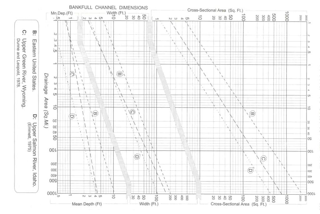
3 without dependence on rock lining, concrete, or steel. A stable stream has the ability, over time, to transport sediment and flows produced by the stream s watershed in such a manner that the stream s dimension, pattern and profile are maintained without agrading or degrading. The consistency of dimension, pattern, and profile that exists among rivers is more than chance or spurious correlation. Mathematical relations exist illustrating a stratification of river systems by unique morphological forms, that provide meaning to an otherwise random appearing, complex set of interrelated variables. (Rosgen, 1996) Fluvial geomorphology has long been studied, but not until recently has the science been applied in such a manner that engineers could begin to use it. The Rosgen Classification System for Natural Rivers was developed for this purpose. (See Table 1.) This classification system allows a designer to determine the range in which a stream s width, depth, sinuosity, entrenchment, slope, and bed will be stable within a particular river valley. Properly applied, this data can be used to design a stable channel that does not depend on hard controls. The design data must be collected at the reference reach, which has been identified for the restoration site. Cross sections and profiles should be surveyed to prepare for extraction of geomorphological data. At the cross section, one will be able to determine the bankfull discharge of the watershed. This stage or elevation is the single most important parameter used in classification, because bankfull is a function of the dimension, pattern, and profile of the stream. Bankfull discharge is associated with a momentary maximum flow that, on the average, has a recurrence interval of 1.5 years as determined using a flood frequency analysis (Dunne and Leopold, 1978). This interval may vary from years for most watersheds to a 1.2 year return for highly developed urban watersheds. A universally accepted definition of bankfull was also provided by Dunne and Leopold in The bankfull stage corresponds to the discharge at which channel maintenance is most effective, that is, the discharge at which moving sediment, forming or removing bars, forming or changing bends and meanders, and generally doing work that results in the average morphological characteristics of channels. Determining bankfull can be accomplished by various methods. First, if a reference reach is available, measurements can be taken as described previously. Second, if a USGS gaging station for a similar channel in the watershed or adjoining watershed is found, data from that station can be analyzed to determine bankfull and other parameters to be utilized in the stream design. Last, if a reference reach or gaging station is not available (which more than likely happens in disturbed mining areas), a regional curve may be used (See Figure 1 and Figure 2). These curves have been developed for various hydro-physiographic provinces in the United States. The curves compare drainage areas to bankfull width, cross-sectional area and mean depth, as well as flows relative to that storm. Ideally, a regional curve should be developed for each local region to provide a more accurate determination of the characteristics of streams in that region. In Pennsylvania, these curves have begun to be developed. Reclamation of mine sites and the construction of natural stream channels will provide data for future regional curve development. 3
4 Once bankfull discharge is known, one can begin to determine the stream type with which one is dealing with by identifying the five (5) primary criteria used for the Rosgen Classification. The five Rosgen criteria are the following: 1) Entrenchment Entrenchment (ER) is generally the ratio of the width of the existing flood prone area (W fpa ), divided by the width of the bankfull stage (W bkf ), ER = W fpa / W bkf where the bankfull width (W bkf ) at the bankfull stage elevation and the flood prone area width (W fpa ) is the width at twice the maximum depth of the bankfull stage. 2) Width/Depth Ratio W fpa = 2(d mbkf ) The width/depth (W/D) ratio is the stream s width at bankfull (W bkf ), divided by its mean depth (d bkf ). W/D = W bkf / d bkf The width/depth ratio will determine the velocity and shear stress distributions within the channel during channel-forming bankfull flows. An improperly dimensioned channel will not be able to transport sediment, and will be susceptible to bank erosion, because the energy is not properly distributed. 3) Sinuosity Sinuosity (K) is the stream length (SL) divided by the valley length (VL). K = SL / VL Sinuosity is the result of the path a stream takes to dissipate energy. In nature, a channel will strive to reach a form where the dissipation of energy is simplest. 4) Channel Materials The composition of the channel bed and banks influences the stream s sediment transportation capability and its resistance to erosion. The analysis of bed materials is done by a pebble count, which measures the size of the bed material. 4
5 5) Slope The slope of a channel is measured as the difference in water surface elevations along a length of stream. A profile taken along the reference reach will identify the slope. The slope of the channel plays a major role in determining the stream classification. The results of the field work and calculations will enable values for the five (5) criteria to be determined. Then a stream type can be chosen using the Rosgen Classification of Natural Rivers. (See Table 1.) This will show the range of values for which the criteria could have fallen within the same stream type. Now, knowing the range, the proper channel can be geometrically fit into the project. The criteria are interdependent. A change in sinuosity will affect the slope, which could change the bankfull dimensions, thereby changing the width/depth ratio and the entrenchment. The proper channel type will be stable at the restoration site only within the ranges of the classification criteria; therefore, site specific design decisions will be necessary to prevent any portion of the project from deviating out of range. After the geometry of the proposed channel is laid out, structures for grade control and bank erosion protection must be designed. Pebble count data in the reference reach riffle area is used, along with bedload data from a point bar (a depositional feature on the inside bend of C type channel) in the stream, to calculate Manning s n, shear stress, and probable scour depth for the proposed channel. To calculate Manning s n : The ratio of bankfull mean water depth (d bkf ) (in millimeters) to the bed material size D84 (mm.) is plotted in a table found in The Reference Reach Field Book, to obtain a dimensionless Fricton Factor (u/u*) (See Figure 3). This number is plotted on another chart in that book to obtain Manning s n (See Figure 4). The Critical Dimensionless Shear Stress ( ci * ) is calculated by the following formula: ci* = (D50/D bed 50) where: D50 = pebble count data (mm.) D bed 50 = sub surface (bar sample) data (mm.) 5
6 This number is used to calculate the maximum scour depth (d) in the pools by the following formula: d = ( ci * 1.65 D i ) / S where: D i = size of largest particle in bar sample (ft.) S = bankfull water surface slope (ft./ft.) The results of these calculations can be used to size rock for the structures. If a reference reach is not found, large size rocks measuring approximately 3 x 3 x 3 may be used for the structures with confidence that it will not be moved during large storm events. Structure type, alignment and construction details can be found in Applied River Morphology. 6
7 LITERATURE CITED Rosgen, D. L. (1996): Applied River Morphology. Printer Media Companies, Minneapolis, Minnesota: 336 pp Rosgen, D. L. (1998): The Reference Reach Field Book, Wildland Hydrology, Pagosa Springs, Colorado: 210 pp 7
8 Entrenchment Ratio Entrenched (Ratio: <1.4) Single-Thread Channels Moderately Entrenched ( ) Slightly Entrenched (> 2.2) Multiple Channels Width/Depth Ratio LOW Width/Depth Ratio (< 12) Moderate to HIGH W/D (> 12) MODERATE Width/Depth Ratio (> 12) VERY LOW Width/Depth (< 12) Moderate to HIGH Width/Depth (> 12) Very HIGH Width/Depth (> 40) LOW W/D (< 40) Sinuosity LOW MODERATE MODERATE MODERATE VERY HIGH HIGH LOW Sinuosity Sinuosity Sinuosity Sinuosity Sinuosity Sinuosity Sinuosity (< 1.2) (> 1.2) (> 1.2) (> 1.2) (> 1.5) (> 1.2) (< 1.2) Low-Hi Sinuosity ( ) Stream Type A G F B E C D Da Slope Slope Range Slope Range Slope Range Slope Range Slope Range Slope Range Slope Range Slope > < < < < < < < CHANNEL MATERIAL Bedrock A1a+ A1 G1 G1c F1b F1 B1a B1 B1c C1b C1 C1c- Boulders A2a+ A2 G2 G2c F2b F2 B2a B2 B2c C2b C2 C2c- Cobble A3a+ A3 G3 G3c F3b F3 B3a B3 B3c E3b E3 C3b C3 C3c- D3b D3 Gravel A4a+ A4 G4 G4c F4b F4 B4a B4 B4c E4b E4 C4b C4 C4c- D4b D4 D4c- DA4 Sand A5a+ A5 G5 G5c F5b F5 B5a B5 B5c E5b E5 C5b C5 C5c- D5b D5 D5c- DA5 Silt/Clay A6a+ A6 G6 G6c F6b F6 B6a B6 B6c E6b E6 C6b C6 C6c- D6b D6 D6c- DA6 Key to the ROSGEN Classification of Natural Rivers. As a function of the continuum of physical variables within stream reaches, values of Entrenchment and Sinuosity ratios can vary by +/- 0.2 units; while values for Width/Depth ratios can vary by +/- 2.0 units. [This table is from Applied River Morphology (Rosgen, 1996).] Table 1
9 Table 1
10 Table 1
11 Table 1
12 Table 1
Stream Classification
 Stream Classification Why Classify Streams? Communication Tool Describe Existing Conditions & Trends Describe Restoration Goals Research Tool Morphologic Stream Classification Systems Schumm (1977) Alluvial
OBJECTIVES. Fluvial Geomorphology? STREAM CLASSIFICATION & RIVER ASSESSMENT
 STREAM CLASSIFICATION & RIVER ASSESSMENT Greg Babbit Graduate Research Assistant Dept. Forestry, Wildlife & Fisheries Seneca Creek, Monongahela National Forest, West Virginia OBJECTIVES Introduce basic
PolyMet NorthMet Project
 RS 26 Draft-01 December 8, 2005 RS26 Partridge River Level 1 Rosgen Geomorphic Survey Rosgen Classification Partridge River from Headwaters to Colby Lake Prepared for PolyMet NorthMet Project December
Riparian Assessment. Steps in the right direction... Drainage Basin/Watershed: Start by Thinking Big. Riparian Assessment vs.
 Riparian Assessment vs. Monitoring Riparian Assessment What is a healthy stream? Determine stream/riparian health Determine change or trend, especially in response to mgmt Classification = designation
Why Stabilizing the Stream As-Is is Not Enough
 Why Stabilizing the Stream As-Is is Not Enough Several examples of alternatives to the County s design approach have been suggested. A common theme of these proposals is a less comprehensive effort focusing
Vermont Stream Geomorphic Assessment. Appendix J. Vermont Regional Hydraulic Geometry Curves
 Vermont Stream Geomorphic Assessment Appendix J Vermont Regional Hydraulic Geometry Curves River Management Program Vermont Water Quality Division November, 2001 Natural Resources - J0 - VT Agency of Background
Field Methods to Determine/ Verify Bankfull Elevation, XS Area & Discharge
 Module # 6 Field Methods to Determine/ Verify Bankfull Elevation, XS Area & Discharge Iowa s River Restoration Toolbox Level 1 / Base Training Overview of Basic Field Data Collection Site Map Cross Sections
Appendix E Rosgen Classification
 Appendix E Stream Type s Using the morphometric parameters described above, stream reaches are classified into 7 major stream types (Aa+ through G) based on s (1996) criteria. The relevant stream classifications
Rosgen Classification Unnamed Creek South of Dunka Road
 Rosgen Classification Unnamed Creek South of Dunka Road Prepared for Poly Met Mining Inc. September 2013 Rosgen Classification Unnamed Creek South of Dunka Road Prepared for Poly Met Mining Inc. September
Implementing a Project with 319 Funds: The Spring Brook Meander Project. Leslie A. Berns
 Implementing a Project with 319 Funds: The Spring Brook Meander Project Leslie A. Berns "...to acquire... and hold lands... for the purpose of protecting and preserving the flora, fauna and scenic beauties...
NATURE OF RIVERS B-1. Channel Function... ALLUVIAL FEATURES. ... to successfully carry sediment and water from the watershed. ...dissipate energy.
 1 2 Function... Sevier River... to successfully carry sediment and water from the watershed....dissipate energy. 3 ALLUVIAL FEATURES 4 CHANNEL DIMENSION The purpose of a stream is to carry water and sediment
Avoiding Geohazards in the Mid-Atlantic Highlands by Using Natural Stream Principles
 Avoiding Geohazards in the Mid-Atlantic Highlands by Using Natural Stream Principles J. Steven Kite, WVU Neal Carte, WVDOT Will Harman, Michael Baker Corp. Donald D. Gray, WVU Photo: W. Gillespie North
The Reference Reach - a Blueprint for Natural Channel Design. Dave Rosgen, P.H. 1
 The Reference Reach - a Blueprint for Natural Channel Design by Dave Rosgen, P.H. 1 Abstract The reference reach is used to develop natural channel design criteria based upon measured morphological relations
The how, why, and lessons learned
 The how, why, and lessons learned emulates natural river systems integrates fluvial processes over temporal and spatial scales of self-formed and self-maintained natural rivers reestablish the physical,
STREAM MODULES: SPREADSHEET TOOLS FOR RIVER EVALUATION, ASSESSMENT AND MONITORING **
 STREAM MODULES: SPREADSHEET TOOLS FOR RIVER EVALUATION, ASSESSMENT AND MONITORING ** D. E. Mecklenburg 1, A. Ward 2 Abstract Stream physical condition is increasingly a priority for resource managers.
Business. Meteorologic monitoring. Field trip? Reader. Other?
 Business Meteorologic monitoring Field trip? Reader Other? Classification Streams Characterization Discharge measurements Why classify stream channels? Why Classify Stream Channels? Provides a common language
Discharge. Discharge (Streamflow) is: Q = Velocity (L T -1 ) x Area (L 2 ) Units: L 3 T -1 e.g., m 3 s -1. Velocity. Area
 is: Q = Velocity (L T -1 ) x Area (L 2 ) Units: L 3 T -1 e.g., m 3 s -1. Velocity. Area") Discharge Discharge (Streamflow) is: Q = Velocity (L T -1 ) x Area (L 2 ) Units: L 3 T -1 e.g., m 3 s -1 Velocity Area Where is the average velocity?? 3 Source: Brooks et al., Hydrology and the Management
Discharge Discharge (Streamflow) is: Q = Velocity (L T -1 ) x Area (L 2 ) Units: L 3 T -1 e.g., m 3 s -1 Velocity Area Where is the average velocity?? 3 Source: Brooks et al., Hydrology and the Management
May 7, Roger Leventhal, P.E. Marin County Public Works Laurel Collins Watershed Sciences
 May 7, 2013 Roger Leventhal, P.E. Marin County Public Works Laurel Collins Watershed Sciences Background Funded in 2009 under EPA 2100 Grant for $30k and managed by SFEP Project Goals: Update original
Assessment. Assessment
 2001 SPRINGBROOK CREEK RESTORATION - THREE YEAR POST-CONSTRUCTION REVIEW - Presented by Bruce Henderson and Andy Harris 2005 River Restoration Northwest Symposium Skamania Lodge, Washington www.hendersonlandservices.com
Ways To Identify Background Verses Accelerated Erosion
 Ways To Identify Background Verses Accelerated Erosion Establish Background Condition From Old Ground Photos, Aerial Photos, and Maps Compare Rate Over Time At the Same Location, or for Reaches Channel
Aquifer an underground zone or layer of sand, gravel, or porous rock that is saturated with water.
 Aggradation raising of the streambed by deposition that occurs when the energy of the water flowing through a stream reach is insufficient to transport sediment conveyed from upstream. Alluvium a general
Technical Supplement 3E. Rosgen Stream Classification Technique Supplemental Materials. (210 VI NEH, August 2007)
") Technical Supplement 3E (210 VI NEH, August 2007) Issued August 2007 Cover photo: The Rosgen stream classification system uses morphometric data to characterize streams. Advisory Note Techniques and approaches
Technical Supplement 3E (210 VI NEH, August 2007) Issued August 2007 Cover photo: The Rosgen stream classification system uses morphometric data to characterize streams. Advisory Note Techniques and approaches
A GEOMORPHOLOGICAL APPROACH TO RESTORATION OF INCISED RIVERS. David L. Rosgen 1
 Proceedings of the Conference on Management of Landscapes Disturbed by Channel Incision, 1997 S.S.Y. Wang, E.J. Langendoen and F.D. Shields, Jr. (eds.) ISBN 0-937099-05-8 A GEOMORPHOLOGICAL APPROACH TO
Watershed Assessment of River Stability and Sediment Supply: Advancing the Science of Watershed Analysis
 Watershed Assessment of River Stability and Sediment Supply: Advancing the Science of Watershed Analysis 2009 MWEA Annual Conference Rob Myllyoja, CET rmyllyoja@hrc-engr.com Watershed Assessment of River
!"#$%&&'()*+#$%(,-./0*)%(!
*+#$%(,-./0*)%(!") 8:30 Sign in Hoosic River Revival Coalition!"#$%&&'()*+#$%(,-./0*)%(! 12-#30+4/#"5-(60 9:00 Welcome and Introductions 9:15 Goals for Today s Program: A Description of the Planning Process 9:30 First Session:
8:30 Sign in Hoosic River Revival Coalition!"#$%&&'()*+#$%(,-./0*)%(! 12-#30+4/#"5-(60 9:00 Welcome and Introductions 9:15 Goals for Today s Program: A Description of the Planning Process 9:30 First Session:
Natural Shoreline Landscapes on Michigan Inland Lakes
 Natural Shoreline Landscapes on Michigan Inland Lakes Excerpts from Chapters 2 and 3 Photo Photo by Jane by Jane Herbert Herbert Did you know? Twenty-four species of amphibians, 25 species of reptiles,
Spreadsheet Tools for Quantifying the Costs and Benefits of Two-Stage Channels
 Spreadsheet Tools for Quantifying the Costs and Benefits of Two-Stage Channels J. Witter, A. Ward, D. Mecklenburg, J. D Ambrosio, S. Roley, and J. Tank AWRA Agricultural Hydrology and Water Quality II
Wetland & Floodplain Functional Assessments and Mapping To Protect and Restore Riverine Systems in Vermont. Mike Kline and Laura Lapierre Vermont DEC
 Wetland & Floodplain Functional Assessments and Mapping To Protect and Restore Riverine Systems in Vermont Mike Kline and Laura Lapierre Vermont DEC NWI+ Hydro-Geomorphic Characterization of Wetlands and
Technical Memorandum. To: From: Copies: Date: 10/19/2017. Subject: Project No.: Greg Laird, Courtney Moore. Kevin Pilgrim and Travis Stroth
 Technical Memorandum To: From: Greg Laird, Courtney Moore Kevin Pilgrim and Travis Stroth 5777 Central Avenue Suite 228 Boulder, CO 80301 www.otak.com Copies: [Electronic submittal] Date: 10/19/2017 Subject:
Tom Ballestero University of New Hampshire. 1 May 2013
 Tom Ballestero University of New Hampshire 1 May 2013 1 Hydrology 2 Basic Hydrology Low flows most common Flows that fill the stream to the banks and higher are much less common Filling the stream to the
Dolores River Watershed Study
 CHAPTER 4: RIVER AND FLOODPLAIN ISSUES The Dolores River falls into a category of streams in Colorado that share some unique characteristics. Like some other mountain streams in the state, it has a steep
Lecture 10: River Channels
 GEOG415 Lecture 10: River Channels 10-1 Importance of channel characteristics Prediction of flow was the sole purpose of hydrology, and still is a very important aspect of hydrology. - Water balance gives
Impacts of Upstream Disturbances on Downstream Sediment Yield and Morphology in the Presence of Best Management Practices
 Impacts of Upstream Disturbances on Downstream Sediment Yield and Morphology in the Presence of Best Management Practices Ilkim Cavus M.S. Student Dr. Latif Kalin Professor Auburn University, School of
SCOPE OF PRESENTATION STREAM DYNAMICS, CHANNEL RESTORATION PLANS, & SEDIMENT TRANSPORT ANALYSES IN RELATION TO RESTORATION PLANS
 DESIGN METHODS B: SEDIMENT TRANSPORT PROCESSES FOR STREAM RESTORATION DESIGN PETER KLINGEMAN OREGON STATE UNIVERSITY CIVIL ENGINEERING DEPT., CORVALLIS 2 ND ANNUAL NORTHWEST STREAM RESTORATION DESIGN SYMPOSIUM
NATURAL RIVER. Karima Attia Nile Research Institute
 NATURAL RIVER CHARACTERISTICS Karima Attia Nile Research Institute NATURAL RIVER DEFINITION NATURAL RIVER DEFINITION Is natural stream of water that flows in channels with ih more or less defined banks.
Limitation to qualitative stability indicators. the real world is a continuum, not a dichotomy ~ 100 % 30 % ~ 100 % ~ 40 %
 Stream Stability Assessment & BEHI Surveys Joe Rathbun MDEQ Water Resources Division rathbunj@michigan.gov 517--373 517 373--8868 Stability Stream can transport its water and sediment inputs without changing
Fluvial Geomorphology
 Geomorphic Components of Riparian Ecosystems W. Barry Southerland, Ph.D. Fluvial Geomorphologist, CPESC #514 West National Technology Support Center Water Quality and Quantity Technology Development Team
CR AAO Bridge. Dead River Flood & Natural Channel Design. Mitch Koetje Water Resources Division UP District
 CR AAO Bridge Dead River Flood & Natural Channel Design Mitch Koetje Water Resources Division UP District Old County Road AAO Bridge Map courtesy of Marquette County Silver Lake Basin McClure Basin
Fish Passage at Road Crossings
 Fish Passage at Road Crossings 1 Crossing Design Workshop Outline 1:00 to 2:00 Intro, Design Overview, Channel Width 2:00 to 2:15 Break 2:15 to 3:15 No-Slope, Stream Simulation Design 3:15 to 3:30 Break
Stream Geomorphology. Leslie A. Morrissey UVM July 25, 2012
 Stream Geomorphology Leslie A. Morrissey UVM July 25, 2012 What Functions do Healthy Streams Provide? Flood mitigation Water supply Water quality Sediment storage and transport Habitat Recreation Transportation
Step 5: Channel Bed and Planform Changes
 Step 5: Channel Bed and Planform Changes When disturbed, streams go through a series of adjustments to regain equilibrium with the flow and sediment supply of their watersheds. These adjustments often
(3) Sediment Movement Classes of sediment transported
 Sediment Movement Classes of sediment transported") (3) Sediment Movement Classes of sediment transported Dissolved load Suspended (and wash load ) Important for scouring algae Bedload (5-10% total load Moves along bed during floods Source of crushing for
(3) Sediment Movement Classes of sediment transported Dissolved load Suspended (and wash load ) Important for scouring algae Bedload (5-10% total load Moves along bed during floods Source of crushing for
Do you think sediment transport is a concern?
 STREAM RESTORATION FRAMEWORK AND SEDIMENT TRANSPORT BASICS Pete Klingeman 1 What is Your Restoration Project Like? k? Do you think sediment transport is a concern? East Fork Lewis River, WA Tidal creek,
Upper Truckee River Restoration Lake Tahoe, California Presented by Brendan Belby Sacramento, California
 Upper Truckee River Restoration Lake Tahoe, California Presented by Brendan Belby Sacramento, California Mike Rudd (Project Manager), Charley Miller & Chad Krofta Declines in Tahoe s Water Clarity The
MEANDER MIGRATION MODEL ASSESSMENT FOR THE JANUARY 2005 STORM, WHITMAN PROPERTY, SAN ANTONIO CREEK, VENTURA COUNTY, CALIFORNIA
 MEANDER MIGRATION MODEL ASSESSMENT FOR THE JANUARY 2005 STORM, WHITMAN PROPERTY, SAN ANTONIO CREEK, VENTURA COUNTY, CALIFORNIA Prepared by Eric Larsen, Ph.D. Mark Rains, Ph.D. October 2006 INTRODUCTION
Griswold Creek August 22, 2013
 Creek August 22, 2013 1 Lake Erie Protection Fund Creek Study ver Evaluate the overall condition of Creek Determine stable channel dimensions & appropriate restoration techniques Starting Stat gpoint for
Two-Stage Channel Design
 United States Department of Agriculture Natural Resources Conservation Service Stream Restoration Design Chapter 10 Issued August 2007 Cover photo: Low gradient, nonincising channels and ditches may be
PENNSYLVANIA DEPARTMENT OF TRANSPORTATION ENGINEERING DISTRICT 3-0
 PENNSYLVANIA DEPARTMENT OF TRANSPORTATION ENGINEERING DISTRICT 3-0 LYCOMING COUNTY S.R.15, SECTION C41 FINAL HYDROLOGIC AND HYDRAULIC REPORT STEAM VALLEY RUN STREAM RELOCATION DATE: June, 2006 REVISED:
GLG598 Surface Processes and Landform Evolution K. Whipple Fall 2012 VERDE RIVER: FLOW MECHANICS, ROUGHNESS, AND SHEAR STRESS
 VERDE RIVER: FLOW MECHANICS, ROUGHNESS, AND SHEAR STRESS This lab will introduce you to some common field techniques and some general understanding of the geomorphic processes operating in a stream. The
Why Geomorphology for Fish Passage
 Channel Morphology - Stream Crossing Interactions An Overview Michael Love Michael Love & Associates mlove@h2odesigns.com (707) 476-8938 Why Geomorphology for Fish Passage 1. Understand the Scale of the
Annotated Bibliography of River Avulsions Pat Dryer Geography 364 5/14/2007
 Annotated Bibliography of River Avulsions Pat Dryer Geography 364 5/14/2007 1 Table of Contents Introduction 2 Annotations I. River avulsions and their deposits 2 II. Channel avulsion on alluvial fans
CASE STUDIES. Introduction
 Introduction The City of Winston-Salem faces the challenge of maintaining public infrastructure (e.g., water and sewer lines, storm drains, roads, culverts and bridges) while minimizing the potential impacts
Diego Burgos. Geology 394. Advisors: Dr. Prestegaard. Phillip Goodling
 Sediment Transport into an Urban Tributary Junction Diego Burgos Geology 394 Advisors: Dr. Prestegaard Phillip Goodling 1 Abstract Tributary junctions are an important component of stream morphology and
(3) Sediment Movement Classes of sediment transported
 Sediment Movement Classes of sediment transported") 9/17/15 (3) Sediment Movement Classes of sediment transported Dissolved load Suspended load Important for scouring algae Bedload (5-10% total load) Moves along bed during floods Source of crushing for
9/17/15 (3) Sediment Movement Classes of sediment transported Dissolved load Suspended load Important for scouring algae Bedload (5-10% total load) Moves along bed during floods Source of crushing for
Thank you to all of our 2015 sponsors: Media Partner
 Thank you to all of our 2015 sponsors: Media Partner Fluvial System Concepts and Their Application in Greenfield Stream Corridor Realignment Dr. Paul Villard, P.Geo. GEO Morphix Ltd. Overview Major realignment
Squaw Creek. General Information
 General Information is a tributary to the Salmon River. It enters the north side of the river about 0 miles downstream of North Fork, Idaho. The study reach is about a 30 ft length of stream about 2 miles
Working with Natural Stream Systems
 Working with Natural Stream Systems Graydon Dutcher Delaware County Soil & Water Conservation District Stream Corridor Management Program Tropical Storm Sandy October 29,2012 What is a Watershed?
Important Copyright Information
 Important Copyright Information The following content is provided for educational purposes by the workshop presenter. This content may or may not have been peer reviewed. Information, opinions and recommendations
Long Valley Meadow Restoration Project
 Long Valley Meadow Restoration Project USDA Forest Service Mogollon Rim Ranger District Coconino National Forest Coconino County, Arizona T13N, R9E, Section 12 and T13N, R10E, Sections 6 and 7 Gila and
Diagnostic Geomorphic Methods for Understanding Future Behavior of Lake Superior Streams What Have We Learned in Two Decades?
 Diagnostic Geomorphic Methods for Understanding Future Behavior of Lake Superior Streams What Have We Learned in Two Decades? Faith Fitzpatrick USGS WI Water Science Center, Middleton, WI fafitzpa@usgs.gov
River Morphology. EAD 511 River management
 River Morphology EAD 511 River management Introduction FLUVIAL GEOMORPHOLOGY Webster's New World Dictionary defines fluvial as: of, found in, or produced by a river or rivers. The same reference defines
Forest Service AOP Meeting Objectives of Stream Simulation: Examples and Talking Points
 Forest Service AOP Meeting Objectives of Stream Simulation: Examples and Talking Points Traci Sylte, P.E. Hydrology/Fluvial Geomorphology Lolo National Forest Is It True? Are Road Crossings a Dam with
Sediment Transport Analysis for Stream Restoration Design: The Good, the Bad, and the Ugly.
 Sediment Transport Analysis for Stream Restoration Design: The Good, the Bad, and the Ugly. Brett Jordan Phd, PE HydroGeo Designs LLC. Land and Water Services Inc. THE GOOD THE BAD THE UGLY THE GOOD THE
Geomorphology Geology 450/750 Spring Fluvial Processes Project Analysis of Redwood Creek Field Data Due Wednesday, May 26
 Geomorphology Geology 450/750 Spring 2004 Fluvial Processes Project Analysis of Redwood Creek Field Data Due Wednesday, May 26 This exercise is intended to give you experience using field data you collected
Session C1 - Applying the Stream Functions Pyramid to Geomorphic Assessments and Restoration Design
 University of Massachusetts - Amherst ScholarWorks@UMass Amherst International Conference on Engineering and Ecohydrology for Fish Passage International Conference on Engineering and Ecohydrology for Fish
Perspectives on river restoration science, geomorphic processes, and channel stability
 Perspectives on river restoration science, geomorphic processes, and channel stability Stream Restoration Forum: Science and Regulatory Connections Andrew C. Wilcox Department of Geosciences University
GLG598 Surface Processes and Landform Evolution K. Whipple VERDE RIVER: FLOW MECHANICS, ROUGHNESS, AND SHEAR STRESS
 VERDE RIVER: FLOW MECHANICS, ROUGHNESS, AND SHEAR STRESS This lab will introduce you to some common field techniques and some general understanding of the geomorphic processes operating in a stream. The
Woodstock, Route 26 Stream Relocation Project
 MAINE DEPARTMENT OF TRANSPORTATION 2006 POST - CONSTRUCTION MONITORING REPORT: Woodstock, Route 26 Stream Relocation Project Year 1 of 5 Compensation for the Woodstock, Route 26 Highway Reconstruction
Watershed concepts for community environmental planning
 Purpose and Objectives Watershed concepts for community environmental planning Dale Bruns, Wilkes University USDA Rural GIS Consortium May 2007 Provide background on basic concepts in watershed, stream,
Rapid Geomorphic Assessments: RGA s
 Establishing Current Reference Conditions Rates and concentrations of suspended-sediment transport vary over time and space due to factors such as precipitation characteristics and discharge, geology,
Office of Structures Manual for Hydrologic and Hydraulic Design. Chapter 14: Stream Morphology and Channel Crossings
 Office of Structures Manual for Hydrologic and Hydraulic Design Chapter 14: Stream Morphology and Channel Crossings August 2007 Preface Federal and state policies and practices that apply to the hydraulic
Overview of fluvial and geotechnical processes for TMDL assessment
 Overview of fluvial and geotechnical processes for TMDL assessment Christian F Lenhart, Assistant Prof, MSU Research Assoc., U of M Biosystems Engineering Fluvial processes in a glaciated landscape Martin
Channel Design. Part 654 Stream Restoration Design National Engineering Handbook. United States Department of Agriculture
 United States Department of Agriculture Natural Resources Conservation Service Stream Restoration Design Rosgen Geomorphic Channel Design Issued August 2007 Cover photo: Stream restoration project, South
ADDRESSING GEOMORPHIC AND HYDRAULIC CONTROLS IN OFF-CHANNEL HABITAT DESIGN
 ADDRESSING GEOMORPHIC AND HYDRAULIC CONTROLS IN OFF-CHANNEL HABITAT DESIGN Conor Shea - Hydrologist U.S. Fish and Wildlife Service Conservation Partnerships Program Arcata, CA Learning Objectives Examine
A classification of natural rivers
 CATENA Catena 22 (1994) 169-199 A classification of natural rivers David L. Rosgen Wildland Hydrology, 157649 U. S. Highway 160, Pagosa Springs, CO 81147 Abstract A classification system for natural rivers
Development of a Fluvial Erosion Hazard Mitigation Program for Indiana
 Development of a Fluvial Erosion Hazard Mitigation Program for Indiana Indiana Watersheds Webinar Series October 12,2011 Robert Barr Center for Earth and Environmental Science Department of Earth Sciences
Session 1 Healthy Streams Stream Hydraulics Natural Channel Design
 Session 1 Healthy Streams Stream Hydraulics Natural Channel Design Bill Brant Heart of America Flyfishers Black & Veatch Kansas City, MO February 21, 2014 http://www.bobswebspace.com Audience? What do
Hydraulic Geometry Relationships for Rural North Carolina Coastal Plain Streams
 Hydraulic Geometry Relationships for Rural North Carolina Coastal Plain Streams Barbara A. Doll 1, Angela D. Dobbins 2, Jean Spooner 3, Daniel R. Clinton 4, David A. Bidelspach 4 ABSTRACT: Hydraulic geometry
DEPARTMENT OF NATURAL RESOURCES FISHERIES DIVISION
 MICHIGAN DEPARTMENT OF NATURAL RESOURCES FISHERIES DIVISION Technical Report 2008-1 September 2008 Regional Hydraulic Geometry Curve for the Upper Menominee River Jessica L. Mistak and Deborah A. Stille
Regional Curves of Hydraulic Geometry for Wadeable Streams. Marin and Sonoma Counties, San Francisco Bay Area. Data Summary Report.
 Regional Curves of Hydraulic Geometry for Wadeable Streams in Marin and Sonoma Counties, San Francisco Bay Area Data Summary Report May 10, 2013 Laurel Collins Watershed Sciences Berkeley, CA Roger Leventhal,
Stream Entrainment, Erosion, Transportation & Deposition
 Lecture 12 Zone 2 of the Fluvial System, Continued Stream Entrainment, Erosion, Transportation & Deposition Erosion in a Fluvial Landscape Corrosion Chemical Erosion Corrasion Mechanical Weathering Cavitation
GENERAL SUMMARY BIG WOOD RIVER GEOMORPHIC ASSESSMENT BLAINE COUNTY, IDAHO
 GENERAL SUMMARY BIG WOOD RIVER GEOMORPHIC ASSESSMENT BLAINE COUNTY, IDAHO Prepared For Trout Unlimited 300 North Main Street, Hailey, Idaho, 83333 Prepared By P. O. Box 8578, 140 E. Broadway, Suite 23,
BZ471, Steam Biology & Ecology Exam 1
 BZ471, Exam1, p.1 BZ471, Steam Biology & Ecology Exam 1 Name Matching. Select the single best (most precise) answer for each of the following. Use each answer no more than once. No partial credit is given.
Big Wood River. General Information
 General Information The flows out of the southern portion of the Sawtooth National Recreation Area in central Idaho. The study reach is about a,200 ft length of river about.5 miles upstream from the discontinued
The Cross-Vane, W-Weir and J-Hook Vane Structures Their Description, Design and Application for Stream Stabilization and River Restoration
 The Cross-Vane, W-Weir and J-Hook Vane Structures Their Description, Design and Application for Stream Stabilization and River Restoration D. L. Rosgen, P.H. * * Professional Hydrologist, Wildland Hydrology,
Hydraulics of bendway weirs
 River Basin Management IV 389 Hydraulics of bendway weirs C. Thornton 1, S. Abt 1, D. Baird 2 & R. Padilla 3 1 Colorado State University, Fort Collins, CO, USA 2 U.S. Bureau of Reclamation, Denver, CO,
Rivers T. Perron
 1 Rivers T. Perron 12.001 After our discussions of large-scale topography, how we represent topography in maps, and how topography interacts with geologic structures, you should be frothing at the mouth
Calculation of Stream Discharge Required to Move Bed Material
 Calculation of Stream Discharge Required to Move Bed Material Objective: Students will map two sections of a stream and calculate the depth, velocity, and discharge of flows required to move the stream
The Yellow River Initiative: The Birth of a System Approach to Challenges Facing the Everglades of the North
 The Yellow River Initiative: The Birth of a System Approach to Challenges Facing the Everglades of the North Robert Barr and Siavash Beik 2016 INAFSM Annual Conference Belterra Conference Center, Indiana
Fluvial Processes in River Engineering
 Fluvial Processes in River Engineering Howard H. Chang San Diego State University... A WILEY-INTERSCIENCE PUBLTCATION John Wiley & Sons New York Chicbester Brisbane Toronto Singapore CONTENTS PARTI FLUVIAL
Field Observations and One-Dimensional Flow Modeling of Summit Creek in Mack Park, Smithfield, Utah
 Intermountain Center for River Rehabilitation and Restoration, Utah State University 31 July 2018 Field Observations and One-Dimensional Flow Modeling of Summit Creek in Mack Park, Smithfield, Utah I.
Methodologies, Regional Analyses, and Application. L. 19cson. Stream management and design recommendations related to the Salmon
 - AN ABSTRACT OF THE THESIS OF Janine M. Castro for the degree of Doctor of Philosophy in Geography presented on January 17, 1997. Title: Stream Classification in the Pacific Northwest: Methodologies,
Upper Mississippi River Basin Environmental Management Program Workshop
 Presentation to the Upper Mississippi River Basin Environmental Management Program Workshop by Michael Rodgers River Engineer US Army Corps of Engineers, St. Louis District August 17, 2007 Engineering
Chapter 3 Erosion in the Las Vegas Wash
 Chapter 3 Erosion in the Las Vegas Wash Introduction As described in Chapter 1, the Las Vegas Wash (Wash) has experienced considerable change as a result of development of the Las Vegas Valley (Valley).
Stream Simulation: A Simple Example
 Stream Simulation: A Simple Example North Thompson Creek, CO Paul T. Anderson U.S.D.A. Forest Service Here s How We Started May 2011 2-1 USDA-Forest Service Here s How We Finished Forest Service Aquatic
GEOL 652. Poudre River Fieldtrip
 GEOL 652. Poudre River Fieldtrip One of the more difficult variables to measure and/or estimate when studying flow in natural channels is that of roughness. Roughness, usually approximated with Manning
Sediment Supply & Hydraulic Continuity: Workshop Review
 Sediment Supply & Hydraulic Continuity: Workshop Review Joe Magner, Ph.D., P.H., P.S.Sc. Minnesota Pollution Control Agency Adjunct Faculty, University of Minnesota Denudation Globally, conventional plowing
SELBY CREEK STREAM HABITAT RESTORATION AND RIPARIAN REVEGETATION PROJECT: GEOMORPHIC ANALYSIS AND REVIEW
 SELBY CREEK STREAM HABITAT RESTORATION AND RIPARIAN REVEGETATION PROJECT: GEOMORPHIC ANALYSIS AND REVIEW Submitted to Bioengineering Institute P.O. Box 1554 Laytonville, CA 95454 By Matthew O Connor, PhD,
Surface Water and Stream Development
 Surface Water and Stream Development Surface Water The moment a raindrop falls to earth it begins its return to the sea. Once water reaches Earth s surface it may evaporate back into the atmosphere, soak
Conceptual Model of Stream Flow Processes for the Russian River Watershed. Chris Farrar
 Conceptual Model of Stream Flow Processes for the Russian River Watershed Chris Farrar Several features of creeks affect the interactions between surface and groundwater. This conceptual model uses the