SELBY CREEK STREAM HABITAT RESTORATION AND RIPARIAN REVEGETATION PROJECT: GEOMORPHIC ANALYSIS AND REVIEW
|
|
|
- Martin Maxwell
- 5 years ago
- Views:
Transcription
1 SELBY CREEK STREAM HABITAT RESTORATION AND RIPARIAN REVEGETATION PROJECT: GEOMORPHIC ANALYSIS AND REVIEW Submitted to Bioengineering Institute P.O. Box 1554 Laytonville, CA By Matthew O Connor, PhD, PG #6847 P.O. Box 794, Healdsburg, California May 25, 2007
2 TABLE OF CONTENTS Introduction... 1 Study Area and Geomorphic Setting... 1 Watershed Characteristics... 1 Alluvial Fan Characteristics and Current Conditions... 2 Influence of Restoration Objectives on Geomorphic Processes... 3 Field Investigation... 4 Field Methods... 5 Results... 5 Hydraulic Analysis and Bed Load Transport Rates... 6 Bankfull Flow Estimates... 6 Bed Load Transport Rate Estimates... 8 Potential Project Impacts on Geomorphic Processes... 9 Conclusions and Recommendations References Cited APPENDIX... 13
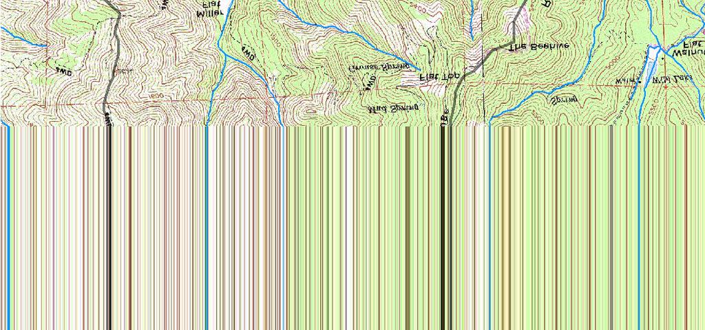
3 Selby Creek Restoration Plan Geomorphic Review 1 Introduction This geomorphic review of the restoration design plan for Selby Creek in the northern Napa River watershed provides an evaluation of the likely effectiveness of the restoration plan, taking into consideration watershed and reach fluvial geomorphology. Specific issues of potential concern include flood potential and channel stability. This analysis provides an overall evaluation of restoration plan objectives and techniques, and identifies proposed restoration plan elements that might be inappropriate for the reach. Elements of the geomorphic review process included review of the restoration plan, field observations pertaining to fluvial geomorphology and reach/site prescriptions, analysis of hydraulics and sediment transport based on independent field surveys conducted for this review, discussion of potential design issues and monitoring objectives with representatives of Bioengineering Institute (the restoration plan designer and contractor), and development of recommendations. The focus of this geomorphic review was modified somewhat from the original scope of work. Observations of field conditions at the outset of the review indicated that potential impacts of the restoration project on flood potential and channel stability should be the primary objective of the geomorphic review. Hence, the review of the project design focused on identifying design elements that would be most likely to affect flooding and channel stability. Study Area and Geomorphic Setting Watershed Characteristics The restoration project area (see maps in Appendix) is the entire length of Selby Creek between its confluence with the Napa River and the road crossing at Silverado Trail. Just above this road crossing is the confluence of two major tributaries comprising the watershed: Biter Creek and Dutch Henry Canyon. These tributaries drain steep mountainous terrain with forest and brush cover underlain by volcanic rocks of the Tertiary age Sonoma Volcanics. Mean annual precipitation for the watershed is about 41 inches. As can be seen in the topographic maps (Appendix), the tributaries in the upper watershed are relatively steep and confined and cross a major break in slope at the transition between the mountain slopes and the valley floor about 1,000 to 2,000 ft upstream from Silverado Trail. Sediment transported in the more energetic channels in the steep mountain valleys will tend to be deposited, at least temporarily, in the flatter valley reaches. Dutch Henry Canyon contains several thousand feet of moderately confined, moderately steep channel upstream of the valley floor, and considerable dynamic sediment storage is likely to exist in that area. Nevertheless, based on the
4 Selby Creek Restoration Plan Geomorphic Review 2 caliber (boulders and cobbles) of sediment deposited upstream of Silverado Trail, sediment transport capacity at the upper end of Selby Creek is high. Although the more abrupt transitions of channel slope and valley width in the watershed occur upstream of Selby Creek, changes in channel slope extend into Selby Creek as channel gradient continues to decline between Silverado Trail and the Napa River confluence. The gradual decline in channel slope is characteristic of the alluvial fan that occupies the portion of the Napa Valley crossed by Selby Creek. The surface of the fan is completely developed in vineyard fields, with a few residential properties fronting Selby Creek near Silverado Trail and near the confluence with the Napa River (see maps in Appendix). Alluvial Fan Characteristics and Current Conditions Typical characteristics of alluvial fan geomorphology include relatively high rates of sediment transport and deposition, concomitant channel instability manifested by bank erosion, channel avulsion and channel migration, shifting and localized occurrence of overbank flow, and declining sediment size and channel slope in the downstream (distal) portions of the fan. Alluvial fan processes are modulated by rates of tectonic uplift, base level change, climate and watershed erosion processes, and land management. Alluvial fan conditions and channel conditions in the study area in the era immediately prior to European settlement are not known with certainty for the project area. It is possible that multiple small channels, or no distinct channel, may have occupied the distal portions of the fan, and that watershed runoff reached the Napa River by a variety of shifting flow paths. Channel morphology is determined primarily by channel gradient and substrate. Channel gradient is variable locally, but is about 0.01 (1%) on average. This suggests that plane bed morphology (a flat-bottomed, rectangular channel) might be expected in steeper locations with pool development most likely to occur where gradient is in the lower end of this range at stream bends or where local flow resistance elements (e.g. woody debris) are present to for channel scour and pool development (Montgomery and Buffington 1997). Gravel dominated substrate is also more likely to develop pool morphology in response to scour caused by resistance elements. Riparian vegetation, particularly tree stems emerging from channel banks, would contribute to the development of pools. Under existing conditions that have evolved over more than 100 years of agricultural development, the position of Selby Creek appears to have been actively maintained by excavation of coarse sediment and placement of this material along the banks in crude levees. This is evident in reaches of Selby Creek upstream of Larkmead Lane (Reaches 1 through 5 in the Restoration Project). Artificial channel enlargement of this type may have affected geomorphic processes in downstream portions of Selby Creek by changing flow and sediment transport conditions. Bank protection measures, including locally extensive rip-rap, are common in the reaches downstream of Larkmead Lane (Restoration
5 Selby Creek Restoration Plan Geomorphic Review 3 Project Reaches 6 and 7). The relative scarcity of mature riparian vegetation limits potential development of pools, and plane bed channel morphology is most typical of the current channel condition. Judging from the high frequency of bare, near-vertical banks and the widespread absence of substantial riparian vegetation, bank erosion is relatively widespread and uncontrolled. Upstream of Larkmead Lane, bank material typically includes coarse and/or cohesive sediment that has relatively high resistance to erosion. Nevertheless, even where erosion resistant bank materials are present, persistent erosion is expected to continue under current conditions. Three major geomorphic discontinuities exist in Selby Creek. First, the Silverado Trail bridge is a major grade control structure that induces some downstream scour and deposition upstream. Conditions at this crossing, particularly fish passage issues, have been investigated recently (Koehler and Blank 2006). Second, the Larkmead Road Bridge creates a backwater effect during periods of bankfull flow under current conditions, inducing deposition of sediment upstream. The channel approaches the bridge at an angle, and under current conditions, the stream energy is focused on the right (southwest) bank. A large gravel bar has formed on the left bank, reducing the crosssection area of one of the bridge archways. The combined effect of turbulence against the bank and reduction of cross-section area by the gravel bar is reduced flow capacity and development of a backwater extending upstream, inducing additional sediment deposition upstream. Finally, at the transition from Restoration Project Reach 7 and 8 (located a short distance downstream of Cross Section 6 as shown in the map, Appendix B), the channel enlarges and gradient increases as the channel steepens in its approach to the Napa River. This suggests that Selby Creek has incised the valley floor in response to declining channel elevation in the Napa River. This grade adjustment can be expected to continue in the future, however, it is modulated to a large degree by flood flows in the Napa River that create a backwater extending well upstream in Reach 8. High rates of channel incision by Selby Creek do not appear to be occurring under present conditions. The continuity of surface flow in Selby Creek is seasonal, with most of the reach going completely dry at the surface during the summer. The water table intersects the channel bed downstream of Larkmead Bridge as the channel gradually dewaters in the spring and summer. The water table appears to reach a stable elevation approximately at the transition from Restoration Project Reach 7 and 8. One of the objectives of the project is to improve aquatic and riparian habitat conditions for steelhead, if possible including extending the seasonal duration of surface flows by deepening the channel thalweg to better maintain contact with the seasonal water table. Influence of Restoration Objectives on Geomorphic Processes The Restoration Project proposes a variety of treatment to stabilize stream banks, create lateral scour forces to encourage development of pools, and to develop stands of native riparian vegetation. Bank stabilization with boulder structures and riparian vegetation will tend to produce roughness elements that will induce lateral scour and initiate
6 Selby Creek Restoration Plan Geomorphic Review 4 development and deepening of a channel thalweg (a distinct continuous thread of high velocity flow in a relatively deep portion of the channel), hopefully progressing to development of sequences of alternating pools and gravel bars. These treatments are also predicted to reduce long-term delivery of sediment by bank erosion to the channel; the Restoration Project predicts that bank erosion will be reduced by about 6,200 yards over an unspecified time period. If this volume of material were spread over the channel bottom over the length of Selby Creek, it would represent approximately 1 ft of deposition. The introduction of riparian vegetation and boulder structures to the channel will also tend to increase channel roughness. The increased flow resistance (channel roughness) of vegetation and boulders is essential to the restoration project, and is expected to produce most of the benefits to aquatic habitat. The increased flow resistance, however, will also tend to increase overall channel roughness, potentially reducing the capacity of the channel and potentially increasing the frequency of overbank flow. The hoped-for shift of channel morphology from plane bed to development of at least some sequences of pools and gravel bars also implies a somewhat higher overall channel roughness. The field component of this investigation, discussed in the following section, was thus designed to investigate the spatial distribution of overbank flow under current conditions and to estimate the spatial variation in sediment transport capacity in Selby Creek. The results of this investigation are then used to develop design and monitoring recommendations for the Restoration Project. Field Investigation The field investigation was conducted in three days, including an initial site reconnaissance with Evan Engber of the Bioengineering Institute. The field reconnaissance familiarized us with the project area and the proposed restoration treatments, and enabled us to identify the aforementioned channel discontinuities. The reconnaissance also allowed for observation of evidence of overbank flow and sediment deposition patterns in Selby Creek. Data and observations regarding channel conditions contained in the Restoration Project proposal were also used for reconnaissance purposes and to confirm preliminary interpretations of geomorphic condition. The reaches where sediment deposition is most significant coincides with reaches that appear to be prone to overbank flow: Restoration Project Reaches 5, 6 and 7, beginning about 1,000 ft upstream of the bridge at Larkmead Lane. We surveyed six cross sections, with concurrent surveys of the channel thalweg gradient and channel surface sediment size distribution. These data were used to estimate channel flow capacity at bankfull and to estimate bed load sediment transport capacity at bankfull flow. Cross section locations were chosen to represent conditions where channel capacity was low and the potential for overbank flow was relatively high.
7 Selby Creek Restoration Plan Geomorphic Review 5 Field Methods Cross section and channel gradient surveys were conducted with a tripod-mounted auto level with elevation measured to the nearest 0.01 ft. Cross sections are graphically displayed in Appendix B; bankfull depth was determined from the cross section graphs as the elevation difference between the lowest point in the channel and the lowest of the two channel banks. Channel gradients were measured over a distance of several channel widths, ranging from 190 ft to 300 ft. Channel gradient was estimate as the slope of a linear regression line passing through the channel elevation data from downstream to upstream. Sediment size distribution was measured with a systematic pebble count, with a count of approximately 150 per cross section site. Results Field data from channel surveys are summarized in Table 1 below. Table 1. Summary of channel survey data. Cross Section Channel slope (ft/ft) Bankfull depth (ft) Median surface sediment diameter (mm) Project Reach As can be seen in Table 1, there is relatively consistent pattern of declining channel gradient in the downstream direction, with a notable deviation at Cross Section 3 located just upstream of the Larkmead Lane bridge. This abrupt slope decline is interpreted to result from locally abundant sediment deposition in the backwater caused by the bridge during times of peak flow. Bankfull depth is lowest in the area upstream of Larkmead Lane (Cross Sections 2 and 3), and the median sediment size at these sections is lower than might be expected relative to areas upstream and downstream considering the overall slope trend. Sediment size distributions are shown in Figure 1. The apparent discontinuity in size distribution, hypothetically resulting from backwater effects at the bridge, is suggested by size distributions at Cross Sections 1 and 4 relative to Cross Sections 2 and 3. Excluding the size distributions at Cross Sections 2 and 3, the size distributions become steadily finer from upstream to downstream. This suggests accelerated depositional processes at Cross Sections 2 and 3, and supports the assessment that the Larkmead Lane bridge causes a discontinuity in the channel.
8 Selby Creek Restoration Plan Geomorphic Review 6 Percent Finer 100% 90% 80% 70% 60% 50% 40% 30% 20% 10% 0% Sediment Diameter (mm) XS 1 (Reach 3) XS 2 (Reach 5) XS 3 (Reach 5) XS 4 (Reach 6) XS 5 (Reach 6) XS 6 (Reach 7) Whole Reach Figure 1. Surface sediment size distributions Hydraulic Analysis and Bed Load Transport Rates The survey data, summarized in Table 1, and the cross section surveys (see Appendix), provided the requisite data to estimate bankfull channel flow capacity using WinXSPro computer software developed by the USDA Forest Service (Hardy, Panja et al. 2005). Given the sediment size distributions (Figure 1), WinXSPro can also produce estimates of bed load sediment transport rate according to a widely-used formula developed for gravel bed streams. Bed load is the coarse sediment, primarily gravel, that is transported during period of peak flow by rolling or skipping along the stream bed. Bankfull Flow Estimates In addition to the survey data described above, an estimate of flow resistance (channel roughness-in this case, Mannings n ) is required to estimate discharge for bankfull flow. Flow resistance is rarely measured directly, and is usually estimated. WinXSPro contains well-known algorithms for estimating roughness; Jarrett (1984) is an appropriate algorithm for Selby Creek based on channel gradient and sediment size. For each of the six cross sections, we computed a range of bankfull flows, with the estimate based on Jarrett s roughness representing the most likely value. The range of flows was extended by evaluating bankfull discharge for the likely potential range of n. The results from this procedure are summarized in Table 2. The estimates in Table 2 provide a means to compare channel capacity at different crosssections, but does not provide any direct perspective on the frequency of flow events that would generate bankfull flows estimated in Table 2. We used the US Geological Survey s flood frequency software, NFF v3.0 (available via the internet from the USGS Water Resources Division web site), to provide flood frequency estimates for Selby Creek (Table 3). Inputs to NFF are watershed drainage area (5.8 sq. mi.), annual
9 Selby Creek Restoration Plan Geomorphic Review 7 precipitation (41 ) and an index number relating to mean watershed elevation (1 for the upper watershsed indicating mean elevation of approximately 1000 ft to the nearest 1000 ft). Table 2. Estimated bankfull discharge for six cross sections over a range of estimated channel roughness values. Bankfull discharge (cfs) Cross Section n from Jarrett Jarrett roughness n =.04 n =.05 n =.06 N =.07 n =.08 n = Table 3. Estimated flood frequency and magnitude from USGS NFF 3.0 for Selby Creek. Recurrence Interval (yrs) Peak Discharge (cfs) Standard Error of Estimate (%) Interval Estimate (Mean +/- 1 std. er.) cfs not determined not determined not determined It is apparent from Table 2 that Cross Sections 3, 4 and 5 have substantially lower bankfull flow capacity than locations further upstream and further downstream. These sections extend from just upstream of Larkmead Lane through Project Reach 6. The best estimate of channel capacity (Jarrett s roughness, third column in Table 2) for these locations is about 330 cfs. Assuming relatively low roughness (n=0.04, fourth column in Table 2), bankfull capacity in this area might be as high as about 440 to 520 cfs. Compared to the mean estimate of peak flow magnitude and frequency summarized in Table 3, stream flow exceeds channel capacity at these three sections more frequently than the one year in two (2 yr recurrence interval, annual probability > 0.5). Considering the low range of peak flow magnitudes, it is possible that stream flow exceeds channel capacity only about once in ten years (10 yr recurrence interval, annual probability about 0.1). It should be noted the in the aforementioned study of fish passage at Silverado Trail, the Napa RCD estimated peak flows for these recurrence intervals to be much higher than predicted by the USGS NFF program. We observed evidence of overbank flow along the left bank (northeast bank) upstream of Larkmead Lane and along the right bank (southwest bank) downstream of Larkmead
10 Selby Creek Restoration Plan Geomorphic Review 8 Lane. Overbank flow channels were evident downstream of Larkmead Lane in spring 2007; overbank sand deposits were observed and sampled in spring of 2006 upstream and downstream of Larkmead Lane. We are certain that overbank flow occurred in these areas during the winter of 2005/2006, and there was a low frequency, high magnitude flood event (approximately 25 yr recurrence interval or greater) in the region on January 1, 2006, but are uncertain regarding the occurrence of overbank flow during the winter of 2006/2007. There was a flow event approaching the 2 year recurrence interval in the region during late December, Based on the hydraulic analysis, flood frequency analysis, and field observations, it is evident that the portion of Selby Creek extending from the vicinity of Larkmead Lane downstream through Project Reach 6 is relatively likely to experience overbank flow (flood) events. Insufficient data are available to determine the frequency of flooding in this reach, but available estimates of flood frequency suggest that the frequency is probably relatively high (annual probability of about 0.5). Bed Load Transport Rate Estimates WinXSPro was used to estimate bed load transport rates for flows ranging up to bankfull. Figure 2 summarizes the bed load transport estimates. It must be emphasized here that bed load transport estimates have high uncertainty, and that the primary value in this application is the relative magnitude of bed load transport among the six surveyed cross sections. Sediment Discharge (lb/s) XS 1, Reach 3 XS 2, Reach 5 XS 3, Reach 5 XS 4, Reach 6 XS 5, Reach 6 XS 6, Reach Water Discharge (cfs) Figure 2. Estimated bed load transport rates as a function of discharge. The bed load transport analysis indicates that transport capacity is greatest at the upstream-most cross sections, with a sharp decline at Cross Section 3 immediately upstream of Larkmead Lane. This localized decline in bed load transport is consistent
11 Selby Creek Restoration Plan Geomorphic Review 9 with field observations, however, it is not likely that the bed load transport rate is near zero at bankfull flow as indicated in Figure 2. The upper end of the curves shown in Figure 2 indicate the approximate relative magnitude of bed load transport rates at bankfull flow, which is physically near the maximum possible rate. Figure 2 shows that the maximum bed load capacity transport capacity occurs at Cross Section 1 and is near 3,000 lbs/sec. Moving downstream, the bed load capacity at Cross Section 2 is about 1,700 lbs/sec, falls to near zero at Cross Section 3, then increases to between about 600 to 900 lbs/sec at Cross Sections 4 to 6. Similarly, at the hypothesized bankfull flow of about 330 cfs in the middle and lower reaches of Selby Creek, bed load transport rates at Cross Sections 1 and 2 would be about 1200 and 800 lbs/sec, respectively, compared to a maximum rate of 500 lbs/sec at Cross Sections 3-5. This indicates that sediment deposition would tend to occur in the lower reaches of Selby Creek, particularly at Larkmead Lane, as the upper reaches may transport more sediment downstream than can be transported in the downstream reaches. The reduction in sediment transport capacity in the middle and lower reaches of Selby Creek could be manifested a decline in surface sediment size distribution. Surface sizes are substantially lower at Cross Sections 2, 3, 5 and 6 relative to 1 and 4. The relatively coarse sediment distribution at Cross Section 4, a short distance downstream of Larkmead Lane, might be in part the result or high deposition rates upstream of Larkmead Lane that effectively lower the sediment supply immediately downstream. Regardless, relative to the upper portion of Selby Creek (Project Reaches 1-4), the lower portion of Selby Creek beginning at Project Reach 5 is likely to be subject to bed load sedimentation. Potential Project Impacts on Geomorphic Processes As described above, Project Reaches 5 and 6 appear to be relatively prone to both sedimentation and overbank flow, and the influence of the Restoration Project on geomorphic processes in this area are a potential concern. The sedimentation process would be expected to be progressive, and create positive feedback: increased deposition reduces channel flow capacity, further reducing bed load transport capacity, increasing sediment deposition, and reducing channel flow capacity. This cycle would also suggest progressively increasing frequency of overbank flow. Although there is evidence suggesting that geomorphic processes alone may be responsible for the hypothesized cycle of sedimentation and reduced channel capacity, there is also evidence that management influences contribute to or cause this cycle. First, channel enlargement in the upper portions of Selby Creek may have increased the efficiency of transport of bed load sediment to the lower reaches of Selby Creek. Second, the large gravel bar formed upstream of Larkmead Lane appears to be a direct result of the hydraulic effects of the bridge that create backwater conditions upstream. Third, channel banks extending about 1,000 ft downstream from Larkmead Lane appear to have been impacted by chain link fence installations that protrude into the channel, and may have increased turbulence near the bank, potentially accelerating erosion. In addition,
12 Selby Creek Restoration Plan Geomorphic Review 10 coarse gravel and cobble removed from vineyard fields appears to be placed along the banks, often in the space between the bank and the chain link fence. In addition, heavy bank rip-rap has been used to armor the banks in several locations, and this may have induced accelerated bank erosion downstream. The combined impact of these uncoordinated, and in some cases, inappropriate, efforts to increase channel capacity or stabilize channel banks may have been to reduce channel flow capacity and increased sedimentation in the lower reaches of Selby Creek. The Restoration Project is a coordinated and comprehensive plan that will provide widely distributed treatments to stabilize stream banks. Proposed plantings and bank protection structures along stream banks will tend to maintain the high velocity thalweg nearer the center of the channel, reducing potential bank erosion and potentially increasing channel depth and pool frequency. This will substantially reduce the potential for accelerated bank erosion in response to uncoordinated bank protection. Ideally, a potential decline in channel capacity associated with increased roughness will be compensated by increased channel depth. The Restoration Project is also expected to reduce bank erosion rates in Selby Creek, reducing the supply of coarse sediment and reducing the potential for sedimentation. Finally, anticipated development of a vegetated riparian corridor could promote formation of natural levees (sand deposits near the top of bank) that tend to occur as high velocity flows in the channel slow and deposit entrained suspended sediment along the edge of the channel. When this material is colonized by vegetation, it can be stabilized and, over periods of decades, increase the height of the stream bank. Conclusions and Recommendations Given the extent and value of vineyard planting that border most of Selby Creek, there is limited opportunity for lateral channel adjustment in the Restoration Project. Consequently, restoration objectives must be met primarily through lateral channel stabilization techniques intended to increase channel depth while maximizing ecological values in the aquatic and riparian environments. Control of erosion processes that contribute to the sediment load of Selby Creek is necessary to optimize the benefits of the Restoration Project. Flooding along Selby Creek appears to occur frequently, particularly in the reach immediately above and below Larkmead Lane. Introduction of roughness elements to the channel to promote desirable aquatic habitat might be expected to induce more frequent flooding, however, the intended long-term effect of the project is to create a deeper channel and reduce sedimentation rates. It should be acknowledged that existing conditions and processes will likely lead to increased flood frequency in the absence of the Restoration Plan. The following recommendations pertain to potential modifications of the Restoration Project design plan, as well as channel and watershed management objectives that would support the Restoration Project s objectives.
13 Selby Creek Restoration Plan Geomorphic Review Reduce or eliminate the proposed use of cross-channel structures that could restrict vertical channel adjustment. Channel adjustment must be accommodated primarily through vertical channel adjustment, which is intended to be manifest by channel deepening. 2. Maximize channel enlargement and avoid channel encroachment in construction of bank stabilization structures. Attempt to increase the cross-sectional area of the channel wherever possible. 3. Encourage the development of a routine channel maintenance procedure in the area immediately upstream of the Larkmead Lane bridge. Excavation of gravel accumulations that obstruct flow through the bridge archways should occur with enough regularity to mitigate the depositional, flood inducing effects of backwater upstream of the bridge. Without such a maintenance program, the geomorphic discontinuity at this location will persist, and the potential for a damaging channel avulsion upstream of the bridge that would route flood flow parallel to Larkmead Lane toward the Napa River. 4. Promote watershed-wide erosion control programs targeting anthropogenic sediment sources in Dutch Henry Canyon and Biter Creek, and along Selby Creek, to reduce long-term sedimentation potential in Selby Creek. Encourage vineyard managers to avoid placing rock and other materials from vineyard along the channel banks that may ultimately enter the channel. 5. Develop a monitoring plan capable of measuring changes in channel geometry that would document the long-term effect of the Restoration Project on channel depth and bankfull capacity.
14 Selby Creek Restoration Plan Geomorphic Review 12 References Cited Hardy, T., P. Panja, et al. (2005). WinXSPRO, A channel cross section analyzer, user's manual, version 3.0, USDA Forest Service Rocky Mountain Research Station. Jarrett, R. (1984). Flow resistance in gravel-bed rivers. Journal of Hydraulic Engineering 105(HY4): Koehler, J. and P. Blank (2006). Selby Creek-Silverado Trail Culvert Fish Passage Assessment. Napa, Napa County Resource Conservation District: 14. Montgomery, D. R. and J. M. Buffington (1997). Channel-reach morphology in mountain drainage basins. Geological Society of America Bulletin 109(5):
15 Selby Creek Restoration Plan Geomorphic Review 13 APPENDIX (Three maps on two 11 x 17 sheets)
16

17
Why Geomorphology for Fish Passage
 Channel Morphology - Stream Crossing Interactions An Overview Michael Love Michael Love & Associates mlove@h2odesigns.com (707) 476-8938 Why Geomorphology for Fish Passage 1. Understand the Scale of the
Summary of Hydraulic and Sediment-transport. Analysis of Residual Sediment: Alternatives for the San Clemente Dam Removal/Retrofit Project,
 Appendix N SUMMARY OF HYDRAULIC AND SEDIMENT-TRANSPORT ANALYSIS OF RESIDUAL SEDIMENT: ALTERNATIVES FOR THE SAN CLEMENTE DAM REMOVAL/RETROFIT PROJECT, CALIFORNIA the San Clemente Dam Removal/Retrofit Project,
Fluvial Driven Alluvial Fans
 Fluvial Driven Alluvial Fans Restoration Project Evaluations - Examples from the Russian and Napa River Watersheds Mia Docto Masters Thesis UC Berkeley 1. Basic Fan Description 2. Fluvial Driven Fan Characteristics
Technical Memorandum. To: From: Copies: Date: 10/19/2017. Subject: Project No.: Greg Laird, Courtney Moore. Kevin Pilgrim and Travis Stroth
 Technical Memorandum To: From: Greg Laird, Courtney Moore Kevin Pilgrim and Travis Stroth 5777 Central Avenue Suite 228 Boulder, CO 80301 www.otak.com Copies: [Electronic submittal] Date: 10/19/2017 Subject:
Stream Geomorphology. Leslie A. Morrissey UVM July 25, 2012
 Stream Geomorphology Leslie A. Morrissey UVM July 25, 2012 What Functions do Healthy Streams Provide? Flood mitigation Water supply Water quality Sediment storage and transport Habitat Recreation Transportation
ADDRESSING GEOMORPHIC AND HYDRAULIC CONTROLS IN OFF-CHANNEL HABITAT DESIGN
 ADDRESSING GEOMORPHIC AND HYDRAULIC CONTROLS IN OFF-CHANNEL HABITAT DESIGN Conor Shea - Hydrologist U.S. Fish and Wildlife Service Conservation Partnerships Program Arcata, CA Learning Objectives Examine
Solutions to Flooding on Pescadero Creek Road
 Hydrology Hydraulics Geomorphology Design Field Services Photo courtesy Half Moon Bay Review Solutions to Flooding on Pescadero Creek Road Prepared for: San Mateo County Resource Conservation District
3/3/2013. The hydro cycle water returns from the sea. All "toilet to tap." Introduction to Environmental Geology, 5e
 Introduction to Environmental Geology, 5e Running Water: summary in haiku form Edward A. Keller Chapter 9 Rivers and Flooding Lecture Presentation prepared by X. Mara Chen, Salisbury University The hydro
!"#$%&&'()*+#$%(,-./0*)%(!
*+#$%(,-./0*)%(!") 8:30 Sign in Hoosic River Revival Coalition!"#$%&&'()*+#$%(,-./0*)%(! 12-#30+4/#"5-(60 9:00 Welcome and Introductions 9:15 Goals for Today s Program: A Description of the Planning Process 9:30 First Session:
8:30 Sign in Hoosic River Revival Coalition!"#$%&&'()*+#$%(,-./0*)%(! 12-#30+4/#"5-(60 9:00 Welcome and Introductions 9:15 Goals for Today s Program: A Description of the Planning Process 9:30 First Session:
APPENDIX E. GEOMORPHOLOGICAL MONTORING REPORT Prepared by Steve Vrooman, Keystone Restoration Ecology September 2013
 APPENDIX E GEOMORPHOLOGICAL MONTORING REPORT Prepared by Steve Vrooman, Keystone Restoration Ecology September 2 Introduction Keystone Restoration Ecology (KRE) conducted geomorphological monitoring in
Squaw Creek. General Information
 General Information is a tributary to the Salmon River. It enters the north side of the river about 0 miles downstream of North Fork, Idaho. The study reach is about a 30 ft length of stream about 2 miles
Aquifer an underground zone or layer of sand, gravel, or porous rock that is saturated with water.
 Aggradation raising of the streambed by deposition that occurs when the energy of the water flowing through a stream reach is insufficient to transport sediment conveyed from upstream. Alluvium a general
Geomorphology Geology 450/750 Spring Fluvial Processes Project Analysis of Redwood Creek Field Data Due Wednesday, May 26
 Geomorphology Geology 450/750 Spring 2004 Fluvial Processes Project Analysis of Redwood Creek Field Data Due Wednesday, May 26 This exercise is intended to give you experience using field data you collected
Implementing a Project with 319 Funds: The Spring Brook Meander Project. Leslie A. Berns
 Implementing a Project with 319 Funds: The Spring Brook Meander Project Leslie A. Berns "...to acquire... and hold lands... for the purpose of protecting and preserving the flora, fauna and scenic beauties...
Erosion Surface Water. moving, transporting, and depositing sediment.
 + Erosion Surface Water moving, transporting, and depositing sediment. + Surface Water 2 Water from rainfall can hit Earth s surface and do a number of things: Slowly soak into the ground: Infiltration
GEOL 652. Poudre River Fieldtrip
 GEOL 652. Poudre River Fieldtrip One of the more difficult variables to measure and/or estimate when studying flow in natural channels is that of roughness. Roughness, usually approximated with Manning
May 7, Roger Leventhal, P.E. Marin County Public Works Laurel Collins Watershed Sciences
 May 7, 2013 Roger Leventhal, P.E. Marin County Public Works Laurel Collins Watershed Sciences Background Funded in 2009 under EPA 2100 Grant for $30k and managed by SFEP Project Goals: Update original
Why Stabilizing the Stream As-Is is Not Enough
 Why Stabilizing the Stream As-Is is Not Enough Several examples of alternatives to the County s design approach have been suggested. A common theme of these proposals is a less comprehensive effort focusing
Fish Passage at Road Crossings
 Fish Passage at Road Crossings 1 Crossing Design Workshop Outline 1:00 to 2:00 Intro, Design Overview, Channel Width 2:00 to 2:15 Break 2:15 to 3:15 No-Slope, Stream Simulation Design 3:15 to 3:30 Break
Carmel River Bank Stabilization at Rancho San Carlos Road Project Description and Work Plan March 2018
 Carmel River Bank Stabilization at Rancho San Carlos Road Project Description and Work Plan March 2018 EXISTING CONDITION The proposed Carmel River Bank Stabilization at Rancho San Carlos Road Project
The last three sections of the main body of this report consist of:
 Threatened and Endangered Species Geological Hazards Floodplains Cultural Resources Hazardous Materials A Cost Analysis section that provides comparative conceptual-level costs follows the Environmental
Business. Meteorologic monitoring. Field trip? Reader. Other?
 Business Meteorologic monitoring Field trip? Reader Other? Classification Streams Characterization Discharge measurements Why classify stream channels? Why Classify Stream Channels? Provides a common language
Tom Ballestero University of New Hampshire. 1 May 2013
 Tom Ballestero University of New Hampshire 1 May 2013 1 Hydrology 2 Basic Hydrology Low flows most common Flows that fill the stream to the banks and higher are much less common Filling the stream to the
GENERAL SUMMARY BIG WOOD RIVER GEOMORPHIC ASSESSMENT BLAINE COUNTY, IDAHO
 GENERAL SUMMARY BIG WOOD RIVER GEOMORPHIC ASSESSMENT BLAINE COUNTY, IDAHO Prepared For Trout Unlimited 300 North Main Street, Hailey, Idaho, 83333 Prepared By P. O. Box 8578, 140 E. Broadway, Suite 23,
MATHEMATICAL MODELING OF FLUVIAL SEDIMENT DELIVERY, NEKA RIVER, IRAN. S.E. Kermani H. Golmaee M.Z. Ahmadi
 JOURNAL OF ENVIRONMENTAL HYDROLOGY The Electronic Journal of the International Association for Environmental Hydrology On the World Wide Web at http://www.hydroweb.com VOLUME 16 2008 MATHEMATICAL MODELING
How Do Human Impacts and Geomorphological Responses Vary with Spatial Scale in the Streams and Rivers of the Illinois Basin?
 How Do Human Impacts and Geomorphological Responses Vary with Spatial Scale in the Streams and Rivers of the Illinois Basin? Bruce Rhoads Department of Geography University of Illinois at Urbana-Champaign
Dolores River Watershed Study
 CHAPTER 4: RIVER AND FLOODPLAIN ISSUES The Dolores River falls into a category of streams in Colorado that share some unique characteristics. Like some other mountain streams in the state, it has a steep
Upper Truckee River Restoration Lake Tahoe, California Presented by Brendan Belby Sacramento, California
 Upper Truckee River Restoration Lake Tahoe, California Presented by Brendan Belby Sacramento, California Mike Rudd (Project Manager), Charley Miller & Chad Krofta Declines in Tahoe s Water Clarity The
Stream Restoration and Environmental River Mechanics. Objectives. Pierre Y. Julien. 1. Peligre Dam in Haiti (deforestation)
") Stream Restoration and Environmental River Mechanics Pierre Y. Julien Malaysia 2004 Objectives Brief overview of environmental river mechanics and stream restoration: 1. Typical problems in environmental
Stream Restoration and Environmental River Mechanics Pierre Y. Julien Malaysia 2004 Objectives Brief overview of environmental river mechanics and stream restoration: 1. Typical problems in environmental
SECTION G SEDIMENT BUDGET
 SECTION G SEDIMENT BUDGET INTRODUCTION A sediment budget has been constructed for the for the time period 1952-2000. The purpose of the sediment budget is to determine the relative importance of different
Ways To Identify Background Verses Accelerated Erosion
 Ways To Identify Background Verses Accelerated Erosion Establish Background Condition From Old Ground Photos, Aerial Photos, and Maps Compare Rate Over Time At the Same Location, or for Reaches Channel
Case Study 2: Twenty-mile Creek Rock Fords
 Case Study : Twenty-mile Creek Rock Fords Location Crossing Description Washington. Okanagan National Forest. Methow Valley Ranger District. Chewuch river basin, East Chewuch Road. The Twenty-mile Creek
Project (Project No. US-CA-62-2) Maintenance Inspection and Reports (Subtask 14.1) Inspection Report No.2
 Maintenance Inspection and Reports (Subtask 14.1) Inspection Report No.2") MEMORANDUM TO: FROM: Jim Well, Ducks Unlimited Mike Harvey, PhD, PG SUBJECT: M&T/ Llano Seco Fish Screen Project (Project No. US-CA-62-2) Maintenance Inspection and Reports (Subtask 14.1) Inspection Report
MEMORANDUM TO: FROM: Jim Well, Ducks Unlimited Mike Harvey, PhD, PG SUBJECT: M&T/ Llano Seco Fish Screen Project (Project No. US-CA-62-2) Maintenance Inspection and Reports (Subtask 14.1) Inspection Report
1 INTRODUCTION AND MAJOR FINDINGS... 1
 Memorandum To: Lindsey Clark, Stillwater Valley Watershed Council Coordinator From: Chad Raisland, Pioneer Technical Services, Inc. and Karin Boyd, Applied Geomorphology, Inc. CC: Tanya Lester, Stillwater
River Response. Sediment Water Wood. Confinement. Bank material. Channel morphology. Valley slope. Riparian vegetation.
 River Response River Response Sediment Water Wood Confinement Valley slope Channel morphology Bank material Flow obstructions Riparian vegetation climate catchment vegetation hydrological regime channel
APPENDIX A REACH DECRIPTIONS. Quantico Creek Watershed Assessment April 2011
 APPENDIX A REACH DECRIPTIONS Basin 615, South Fork of Quantico Creek - Project Reach Descriptions Reach Name: 615-A Coordinates (NAD 83, Virginia State Plane North): 11796510.57, 6893938.95 to 11801555.79,
GLG362/GLG598 Geomorphology K. Whipple October, 2009 I. Characteristics of Alluvial Channels
 I. Characteristics of Alluvial Channels Self-formed morphology set by entrainment, transport, and deposition They move unconsolidated sedimentary materials present in the valley fill flood plain/bank flow
mountain rivers fixed channel boundaries (bedrock banks and bed) high transport capacity low storage input output
 high transport capacity low storage input output") mountain rivers fixed channel boundaries (bedrock banks and bed) high transport capacity low storage input output strong interaction between streams & hillslopes Sediment Budgets for Mountain Rivers Little
mountain rivers fixed channel boundaries (bedrock banks and bed) high transport capacity low storage input output strong interaction between streams & hillslopes Sediment Budgets for Mountain Rivers Little
SCOPE OF PRESENTATION STREAM DYNAMICS, CHANNEL RESTORATION PLANS, & SEDIMENT TRANSPORT ANALYSES IN RELATION TO RESTORATION PLANS
 DESIGN METHODS B: SEDIMENT TRANSPORT PROCESSES FOR STREAM RESTORATION DESIGN PETER KLINGEMAN OREGON STATE UNIVERSITY CIVIL ENGINEERING DEPT., CORVALLIS 2 ND ANNUAL NORTHWEST STREAM RESTORATION DESIGN SYMPOSIUM
DETAILED DESCRIPTION OF STREAM CONDITIONS AND HABITAT TYPES IN REACH 4, REACH 5 AND REACH 6.
 DETAILED DESCRIPTION OF STREAM CONDITIONS AND HABITAT TYPES IN REACH 4, REACH 5 AND REACH 6. The Eklutna River was divided into study reaches (figure 1) prior to this site visit. Prominent geologic or
The effectiveness of check dams in controlling upstream channel stability in northeastern Taiwan
 Erosion, Debris Mows and Environment in Mountain Regions (Proceedings of the Chengdu Symposium, July 1992). IAHS Publ. no. 209, 1992. 423 The effectiveness of check dams in controlling upstream channel
Do you think sediment transport is a concern?
 STREAM RESTORATION FRAMEWORK AND SEDIMENT TRANSPORT BASICS Pete Klingeman 1 What is Your Restoration Project Like? k? Do you think sediment transport is a concern? East Fork Lewis River, WA Tidal creek,
Four Mile Run Levee Corridor Stream Restoration
 Four Mile Run Levee Corridor Stream Restoration 30% Design Summary U.S. Army Corps of Engineers, Baltimore District Presentation Outline Four Mile Run 1.) Historic Perspective 2.) Existing Conditions 3.)
Geomorphic Importance of Winter Peak Flows and Annual Snowmelt Hydrographs in a Sierra Nevada Boulder-Bedrock River
 Geomorphic Importance of Winter Peak Flows and Annual Snowmelt Hydrographs in a Sierra Nevada Boulder-Bedrock River Scott McBain and Bill Trush McBain & Trush, Inc. Clavey River and Cherry Creek vicinity
OBJECTIVES. Fluvial Geomorphology? STREAM CLASSIFICATION & RIVER ASSESSMENT
 STREAM CLASSIFICATION & RIVER ASSESSMENT Greg Babbit Graduate Research Assistant Dept. Forestry, Wildlife & Fisheries Seneca Creek, Monongahela National Forest, West Virginia OBJECTIVES Introduce basic
Field Observations and One-Dimensional Flow Modeling of Summit Creek in Mack Park, Smithfield, Utah
 Intermountain Center for River Rehabilitation and Restoration, Utah State University 31 July 2018 Field Observations and One-Dimensional Flow Modeling of Summit Creek in Mack Park, Smithfield, Utah I.
Section 4: Model Development and Application
 Section 4: Model Development and Application The hydrologic model for the Wissahickon Act 167 study was built using GIS layers of land use, hydrologic soil groups, terrain and orthophotography. Within
River Nith restoration, cbec UK Ltd, October 2013 APPENDIX A
 APPENDIX A FLUVIAL AUDIT METHOD STATEMENT Fluvial Audit Methodology INTRODUCTION The procedure used to characterize the geomorphic and sedimentary regimes of the River Till is an adaptation of the Fluvial
PolyMet NorthMet Project
 RS 26 Draft-01 December 8, 2005 RS26 Partridge River Level 1 Rosgen Geomorphic Survey Rosgen Classification Partridge River from Headwaters to Colby Lake Prepared for PolyMet NorthMet Project December
Monitoring Headwater Streams for Landscape Response to
 Monitoring Headwater Streams for Landscape Response to Climate Change Matthew Connor, PhD Connor nvironmental, nc. www.oe-i.com icom Healdsburg, California verview Headwater stream geomorphology Response
Design and Construction
 Design and Construction Stream Simulation With power point slides shamelessly stolen from: Forest Service AOP Training Course Bob Gubernick Paul Anderson John Kattell USDA Forest Service Interim Directive
Technical Memorandum No Sediment Model
 Pajaro River Watershed Study in association with Technical Memorandum No. 1.2.9 Sediment Model Task: Development of Sediment Model To: PRWFPA Staff Working Group Prepared by: Gregory Morris and Elsie Parrilla
Big Wood River. General Information
 General Information The flows out of the southern portion of the Sawtooth National Recreation Area in central Idaho. The study reach is about a,200 ft length of river about.5 miles upstream from the discontinued
PENNSYLVANIA DEPARTMENT OF TRANSPORTATION ENGINEERING DISTRICT 3-0
 PENNSYLVANIA DEPARTMENT OF TRANSPORTATION ENGINEERING DISTRICT 3-0 LYCOMING COUNTY S.R.15, SECTION C41 FINAL HYDROLOGIC AND HYDRAULIC REPORT STEAM VALLEY RUN STREAM RELOCATION DATE: June, 2006 REVISED:
Stream Simulation: A Simple Example
 Stream Simulation: A Simple Example North Thompson Creek, CO Paul T. Anderson U.S.D.A. Forest Service Here s How We Started May 2011 2-1 USDA-Forest Service Here s How We Finished Forest Service Aquatic
Restoration Goals TFG Meeting. Agenda
 San Joaquin River Restoration Program Restoration Goals TFG Meeting Reach 2B Update April 28, 2010 Agenda 1. Introductions 2. Program Restoration Goal Context 3. Program Update a) Interim Flows b) EIS/EIR
CR AAO Bridge. Dead River Flood & Natural Channel Design. Mitch Koetje Water Resources Division UP District
 CR AAO Bridge Dead River Flood & Natural Channel Design Mitch Koetje Water Resources Division UP District Old County Road AAO Bridge Map courtesy of Marquette County Silver Lake Basin McClure Basin
Surface Water and Stream Development
 Surface Water and Stream Development Surface Water The moment a raindrop falls to earth it begins its return to the sea. Once water reaches Earth s surface it may evaporate back into the atmosphere, soak
Sessom Creek Sand Bar Removal HCP Task 5.4.6
 Sessom Creek Sand Bar Removal HCP Task 5.4.6 Prepared by: Dr. Thomas Hardy Texas State University Dr. Nolan Raphelt Texas Water Development Board January 6, 2013 DRAFT 1 Introduction The confluence of
Stream Classification
 Stream Classification Why Classify Streams? Communication Tool Describe Existing Conditions & Trends Describe Restoration Goals Research Tool Morphologic Stream Classification Systems Schumm (1977) Alluvial
ES 105 Surface Processes I. Hydrologic cycle A. Distribution % in oceans 2. >3% surface water a. +99% surface water in glaciers b.
 ES 105 Surface Processes I. Hydrologic cycle A. Distribution 1. +97% in oceans 2. >3% surface water a. +99% surface water in glaciers b. >1/3% liquid, fresh water in streams and lakes~1/10,000 of water
Summary. Streams and Drainage Systems
 Streams and Drainage Systems Summary Streams are part of the hydrologic cycle and the chief means by which water returns from the land to the sea. They help shape the Earth s surface and transport sediment
Black Gore Creek 2013 Sediment Source Monitoring and TMDL Sediment Budget
 Black Gore Creek 2013 Sediment Source Monitoring and TMDL Sediment Budget Prepared for: Prepared By: - I. Introduction The Black Gore Creek Total Maximum Daily Load (TMDL) was developed in collaboration
Assessment. Assessment
 2001 SPRINGBROOK CREEK RESTORATION - THREE YEAR POST-CONSTRUCTION REVIEW - Presented by Bruce Henderson and Andy Harris 2005 River Restoration Northwest Symposium Skamania Lodge, Washington www.hendersonlandservices.com
Assignment 1. Measuring River Characteristics- Vernon Creek. Applied Fluvial Geomorphology Field Techniques EESc 435
 Assignment 1 Measuring River Characteristics- Vernon Creek Applied Fluvial Geomorphology Field Techniques EESc 435 Amanda Jardine 30100093 Jaime McDonald 14177083 Erica Massey 50870088 April 28, 2012 Introduction
Technical Memorandum No
 Pajaro River Watershed Study in association with Technical Memorandum No. 1.2.10 Task: Evaluation of Four Watershed Conditions - Sediment To: PRWFPA Staff Working Group Prepared by: Gregory Morris and
Appendix F Channel Grade Control Structures
 Stream Simulation Appendix F Channel Grade Control Structures This appendix briefly describes permanent grade control structures that are sometimes needed in the upstream and/or downstream reaches adjacent
Appendix III-A Descriptions of Channel Habitat Types
 Appendix III-A Descriptions of Channel Habitat Types Table of Contents Channel Habitat Typing Background... 3 Small Estuarine Channel (ES)... 7 Large Estuarine Channel (EL)... 9 Low Gradient Large Floodplain
STUDY GUIDE FOR CONTENT MASTERY. Surface Water Movement
 Surface Water SECTION 9.1 Surface Water Movement In your textbook, read about surface water and the way in which it moves sediment. Complete each statement. 1. An excessive amount of water flowing downslope
Step 5: Channel Bed and Planform Changes
 Step 5: Channel Bed and Planform Changes When disturbed, streams go through a series of adjustments to regain equilibrium with the flow and sediment supply of their watersheds. These adjustments often
APPENDIX B Hydraulic Considerations for Pipeline Crossings of Stream Channels
 APPENDIX B Hydraulic Considerations for Pipeline Crossings of Stream Channels B-1 B-2 APPENDIX B HYDRAULIC CONSIDERATIONS FOR PIPELINE CROSSINGS OF STREAM CHANNELS Pipeline crossings of perennial, intermittent,
Environmental Geology Chapter 9 Rivers and Flooding
 Environmental Geology Chapter 9 Rivers and Flooding Flooding in Pakistan 2010-1600 killed/20000 affected The hydrologic cycle is powered by the Sun The cycle includes evaporation, precipitation, infiltration,
Historical channel change on the Upper Gila River, Arizona and New Mexico in response to anthropogenic modifications and extreme floods
 Historical channel change on the Upper Gila River, Arizona and New Mexico in response to anthropogenic modifications and extreme floods www.archives.gov www.paztcn.wr.usgs.gov wrh.noaa.gov Upper Gila River
Field Methods to Determine/ Verify Bankfull Elevation, XS Area & Discharge
 Module # 6 Field Methods to Determine/ Verify Bankfull Elevation, XS Area & Discharge Iowa s River Restoration Toolbox Level 1 / Base Training Overview of Basic Field Data Collection Site Map Cross Sections
Riparian Assessment. Steps in the right direction... Drainage Basin/Watershed: Start by Thinking Big. Riparian Assessment vs.
 Riparian Assessment vs. Monitoring Riparian Assessment What is a healthy stream? Determine stream/riparian health Determine change or trend, especially in response to mgmt Classification = designation
Overview of fluvial and geotechnical processes for TMDL assessment
 Overview of fluvial and geotechnical processes for TMDL assessment Christian F Lenhart, Assistant Prof, MSU Research Assoc., U of M Biosystems Engineering Fluvial processes in a glaciated landscape Martin
Dan Miller + Kelly Burnett, Kelly Christiansen, Sharon Clarke, Lee Benda. GOAL Predict Channel Characteristics in Space and Time
 Broad-Scale Models Dan Miller + Kelly Burnett, Kelly Christiansen, Sharon Clarke, Lee Benda GOAL Predict Channel Characteristics in Space and Time Assess Potential for Fish Use and Productivity Assess
3.12 Geology and Topography Affected Environment
 3 Affected Environment and Environmental Consequences 3.12 Geology and Topography 3.12.1 Affected Environment 3.12.1.1 Earthquakes Sterling Highway MP 45 60 Project Draft SEIS The Kenai Peninsula is predisposed
Vermont Stream Geomorphic Assessment. Appendix J. Vermont Regional Hydraulic Geometry Curves
 Vermont Stream Geomorphic Assessment Appendix J Vermont Regional Hydraulic Geometry Curves River Management Program Vermont Water Quality Division November, 2001 Natural Resources - J0 - VT Agency of Background
CASE STUDIES. Introduction
 Introduction The City of Winston-Salem faces the challenge of maintaining public infrastructure (e.g., water and sewer lines, storm drains, roads, culverts and bridges) while minimizing the potential impacts
Evaluation of Geomorphic Effects of Removal of Marmot and Little Sandy Dams and Potential Impacts on Anadromous Salmonids
 PRELIMINARY FINAL Evaluation of Geomorphic Effects of Removal of Marmot and Little Sandy Dams and Potential Impacts on Anadromous Salmonids Prepared for: Portland General Electric 121 SW Salmon Street
Streams. Water. Hydrologic Cycle. Geol 104: Streams
 Streams Why study streams? Running water is the most important geologic agent in erosion, transportation and deposition of sediments. Water The unique physical and chemical properties of water make it
Vermont Stream Geomorphic Assessment. Appendix E. River Corridor Delineation Process. VT Agency of Natural Resources. April, E0 - April, 2004
 Vermont Stream Geomorphic Assessment Appendix E River Corridor Delineation Process Vermont Agency of Natural Resources - E0 - River Corridor Delineation Process Purpose A stream and river corridor delineation
Watershed concepts for community environmental planning
 Purpose and Objectives Watershed concepts for community environmental planning Dale Bruns, Wilkes University USDA Rural GIS Consortium May 2007 Provide background on basic concepts in watershed, stream,
Rapid Geomorphic Assessments: RGA s
 Establishing Current Reference Conditions Rates and concentrations of suspended-sediment transport vary over time and space due to factors such as precipitation characteristics and discharge, geology,
Gully Erosion Part 1 GULLY EROSION AND ITS CAUSES. Introduction. The mechanics of gully erosion
 Gully Erosion Part 1 GULLY EROSION AND ITS CAUSES Gully erosion A complex of processes whereby the removal of soil is characterised by incised channels in the landscape. NSW Soil Conservation Service,
Long Valley Meadow Restoration Project
 Long Valley Meadow Restoration Project USDA Forest Service Mogollon Rim Ranger District Coconino National Forest Coconino County, Arizona T13N, R9E, Section 12 and T13N, R10E, Sections 6 and 7 Gila and
What discharge (cfs) is required to entrain the D 84 (84 th percentile of sediment size distribution) in Red Canyon Wash?
 is required to entrain the D 84 (84 th percentile of sediment size distribution) in Red Canyon Wash?") Gregory Indivero 31 October 2011 What discharge (cfs) is required to entrain the D 84 (84 th percentile of sediment size distribution) in Red Canyon Wash? What discharge was required to deposit observed
Gregory Indivero 31 October 2011 What discharge (cfs) is required to entrain the D 84 (84 th percentile of sediment size distribution) in Red Canyon Wash? What discharge was required to deposit observed
NORTHUMBERLAND COUNTY, PA
 QUAKER RUN Stream and Wetland Restoration As-Built Completion Report and First Year Monitoring Data Coal Township NORTHUMBERLAND COUNTY, PA Upstream Before Upstream After Prepared for: COAL TOWNSHIP 805
Rosgen Classification Unnamed Creek South of Dunka Road
 Rosgen Classification Unnamed Creek South of Dunka Road Prepared for Poly Met Mining Inc. September 2013 Rosgen Classification Unnamed Creek South of Dunka Road Prepared for Poly Met Mining Inc. September
River Restoration and Rehabilitation. Pierre Y. Julien
 River Restoration and Rehabilitation Pierre Y. Julien Department of Civil and Environmental Engineering Colorado State University Fort Collins, Colorado River Mechanics and Sediment Transport Lima Peru
Hydrologic hazards can be considered in three categories; An indication of flooding potential for areas located
 4.0 General Hydrologic Design Critera 4.1 Hydrologic Hazards Hydrologic hazards can be considered in three categories; flooding, channel migration, and tributary stajility. An indication of flooding potential
6.11 Naas River Management Unit
 6.11 Naas River Management Unit 6.11.1 Site 41 Issue: Bed and bank erosion Location: E 0685848 N 6058358 Waterway: Naas River Management Unit: Naas River Facing downstream from Bobeyan Rd bridge Facing
Diagnostic Geomorphic Methods for Understanding Future Behavior of Lake Superior Streams What Have We Learned in Two Decades?
 Diagnostic Geomorphic Methods for Understanding Future Behavior of Lake Superior Streams What Have We Learned in Two Decades? Faith Fitzpatrick USGS WI Water Science Center, Middleton, WI fafitzpa@usgs.gov
Wetland & Floodplain Functional Assessments and Mapping To Protect and Restore Riverine Systems in Vermont. Mike Kline and Laura Lapierre Vermont DEC
 Wetland & Floodplain Functional Assessments and Mapping To Protect and Restore Riverine Systems in Vermont Mike Kline and Laura Lapierre Vermont DEC NWI+ Hydro-Geomorphic Characterization of Wetlands and
UPPER COSUMNES RIVER FLOOD MAPPING
 UPPER COSUMNES RIVER FLOOD MAPPING DRAFT BASIC DATA NARRATIVE FLOOD INSURANCE STUDY SACRAMENTO COUTY, CALIFORNIA Community No. 060262 November 2008 Prepared By: CIVIL ENGINEERING SOLUTIONS, INC. 1325 Howe
DRAFT Design Hydraulic Study. Bridge 04C-0055, Mattole Road Bridge over Mattole River at Honeydew. Humboldt County. Prepared for:
 DRAFT Design Hydraulic Study Bridge 04C-0055, Mattole Road Bridge over Mattole River at Honeydew Humboldt County Prepared for: Morrison Structures Incorporated 1890 Park Marina Drive, Suite 104 Redding,
EAGLES NEST AND PIASA ISLANDS
 EAGLES NEST AND PIASA ISLANDS HABITAT REHABILITATION AND ENHANCEMENT PROJECT MADISON AND JERSEY COUNTIES, ILLINOIS ENVIRONMENTAL MANAGEMENT PROGRAM ST. LOUIS DISTRICT FACT SHEET I. LOCATION The proposed
7.3 Sediment Delivery Analysis
 7.3 Sediment Delivery Analysis In order to evaluate potential changes in sedimentation patterns that could occur due to impacts from the FCP and LPP alignments, sediment assessment models were constructed
Woodstock, Route 26 Stream Relocation Project
 MAINE DEPARTMENT OF TRANSPORTATION 2006 POST - CONSTRUCTION MONITORING REPORT: Woodstock, Route 26 Stream Relocation Project Year 1 of 5 Compensation for the Woodstock, Route 26 Highway Reconstruction