Uncertainty in Geographic Information: House of Cards? Michael F. Goodchild University of California Santa Barbara
|
|
|
- Ross Russell Rose
- 5 years ago
- Views:
Transcription
1 Uncertainty in Geographic Information: House of Cards? Michael F. Goodchild University of California Santa Barbara
2 Starting points All geospatial data leave the user to some extent uncertain about the state of the real world missing data positional and attribute errors uncertain definitions of classes and terms missing metadata projection unspecified horizontal or vertical datum cartographic license

3

4
5 Uncertainty is endemic All geographic information leaves some degree of uncertainty about conditions in the real world x the Greenwich Meridian the Equator standard time z definitions of terms errors of measurement
6 Starting points Some applications will be impacted, some will not for any given data set at least one application can be found where uncertainty matters knowing whether data are fit for use Our perspective on these issues has changed in the past two decades from error to uncertainty from top-down to bottom-up data production

7


8

9

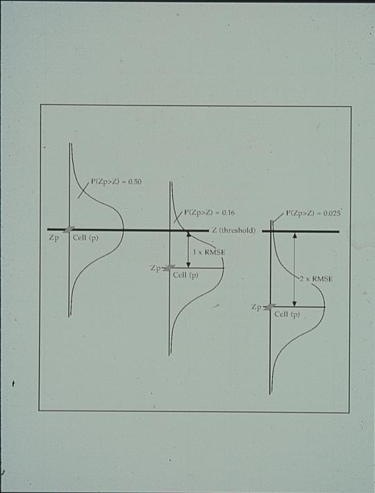
10

11

12
13 Precision: Definitions of terms the number of significant digits used to report a measurement should never be more than is justified by the accuracy of the measuring device internal precision of the computer single precision arithmetic 1 part in 10 7 double precision 1 part in relative to the Earth's dimensions, single precision is about a meter resolution, double is about the size of an atom no GIS should ever need more than single precision a GIS's internal precision is effectively infinite hard to persuade designers to drop those spurious digits

14


15
16 Scale Relationship between measurement of distance on a map and measurement on the ground 1:24,000 is larger than 1:250,000 A map used for digitizing or scanning always has a scale a geospatial database never has scale but we have complex conventions Scale as a useful surrogate for map contents, resolution, accuracy scale of original map a useful item of geospatial metadata
17 Resolution The minimum distance over which change is recorded 0.5mm for a paper map Positional accuracy set by national map accuracy standards to roughly 0.5mm
18 Accuracy The difference between a measurement and the truth problems of defining truth for some geospatial variables, e.g. soil class if two people classified the same site would they agree? Uncertainty of definition is a form of inaccuracy, along with: variation between observers or measuring instruments temporal change loss of information on e.g. projection, datum transformation of datum map registration digitizing error imperfect fit of the data model, e.g. heterogeneous polygons, transition zones instead of boundaries fuzziness of many geographic concepts transformation of coordinate system, projection, data model, e.g. raster/vector conversion
19 Truth Often a source of higher accuracy circularity - accuracy is the difference between a measurement and a source of higher accuracy? What identifies a source as having higher accuracy? larger scale more recent cost more, took longer to make, more careful more accurate measuring instrument certified by an expert earlier in the chain reality-map-database (less processing)
20 The problem Uncertainty is endemic in geospatial data even a 1:1 mapping would not create a perfect representation of reality All GIS products are therefore subject to uncertainty what is the plus or minus on estimates of length, area, counts of objects, positions, attributes, viewsheds, buffer zones,... GIS products are often used in decision-making by people who do not have intimate knowledge of the methods used to collect, digitize or process the data results are often presented and used visually rather than numerically Computer (GIS) output carries a false sense of credibility

21
22 Topology vs geometry Which property does this pole lie in? Which side of the street is this house? Do these two streets connect?
23 Acres > Totals
24 Data types The area-class map soil maps vegetation cover type land use Boundaries surrounding areas of uniform type what s the accuracy issue?
25

26
27 The area class map Assigns every location x to a class Mark and Csillag term c = f(x) a nominal field (or perhaps ordinal) classified scene soil map, vegetation cover map, land use map Need to model uncertainty in this type of map
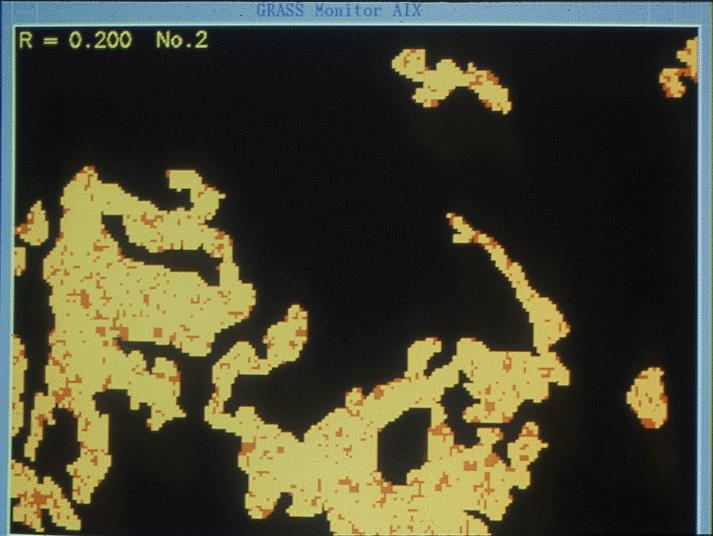
28 Uncertainty modeling Area-class maps are made by a long and complex process involving many stages, some partially subjective Maps of the same theme for the same area will not be the same level of detail, generalization vague definitions of classes variation among observers measuring instrument error different classifiers, training sites different sensors
29 Error and uncertainty Error: true map plus distortion systematic measurements disturbed by stochastic effects accuracy (deviation from true value) precision (deviation from mean value) variation ascribed to error Uncertainty: differences reflect uncertainty about the real world no true map possible consensus map combining maps can improve estimates
30 Models of uncertainty Determine effects of uncertainty/variation/error on results of analysis if there is known variation, the results of a single analysis cannot be claimed to be correct uncertainty analysis an essential part of GIS error model the preferred term
31 Traditional error analysis Measurements subject to distortion z' = z + δz Propagate through transformations r = f(z) r + δr = f(z + δz) But f is rarely known complex compilation and interpretation complex spatial dependencies between elements of resulting data set
32 Spatial dependence In true values z In errors e cov(e i,e j ) a decreasing positive function of distance geostatistical framework Scale effects, generalization as convolutions of z
33 If this were not true If Tobler s First Law of Geography did not apply to errors in maps If errors were statistically independent If relative errors were as large as absolute errors Errors in derived products would be impossibly large e.g. slope e.g. length Shapes would be unrecognizable
34 Realization A single instance from an error model an error model must be stochastic Monte Carlo simulation The Gaussian distribution metaphor scalar realizations a Gaussian distribution for maps an entire map as a realization
35 The area class map Field of nominal values c(x), n>1 spatially autocorrelated in raster, count of i,i joins greater than expected In vector, collection of discrete objects nodes, edges, areas in coverage model polygons in shapefile model
36 A collection of discrete objects Three conflicts with the observed nature of areaclass maps In repeated mappings, positions, attributes, and numbers of objects will vary (topological variation) Positional uncertainties will vary widely depending on boundary clarity Confusion of attributes will vary within polygons may be greatest in the center contrary to the egg-yolk model
37 suburban core land use type urban
38
39
40 Model {p 1,p 2,,p n } correlation in neighboring cell outcomes posterior probabilities equal to priors 80% sand, 20% inclusions of clay no knowledge of correlations
41
42
43
44
45
46

47

48
49
50 Topographic data Definition problems sand dunes trees buildings Classic measurement error model measured elevation = truth + error error spatially autocorrelated

51
52

53

54
55 z'(x) = z(x) + δz(x)

56 Glyphs indicating wind direction, magnitude, and uncertainty (Pang, 2001)

57 Representation of estimated water balance surplus/deficit (using a mesh surface) and uncertainty in the estimates (using bars above and below the surface). The bars depict the range of a set of model predictions with those predictions above the mean in purple and those below the mean in orange. Fauerbach, Edsall, Barnes, MacEachren animation
58 Options for uncertainty Ignore Present parameters Present simulations confidence intervals
; (b) crispness of symbol edge middle; and (c) transparency of symbol")
59 Point symbol sets depicting uncertainty with variation in (a) saturation (colors vary from saturated green, bottom, to unsaturated, top); (b) crispness of symbol edge middle; and (c) transparency of symbol right.
.")
60 Alternative depictions of data (inorganic nitrogen in Chesapeake Bay) and uncertainty of data interpolated from sparse point samples. Left view shows bivariate depiction in which dark=more nitrogen and certainty is depicted with a diverging color scheme (blue = most certain and red = most uncertain). Right view depicts data in both panels (dark = more nitrogen), with the right panel showing the results of interactive focusing on the most certain data.
61 Communication of uncertainty Producer to user abilities Metadata standards parameters of complex models Assertion: all knowledge of uncertainty can be expressed in a suitable simulation model equally likely realizations
62
63 The "five-fold way" Positional accuracy Attribute accuracy Logical consistency Completeness Lineage Federal Geographic Data Committee Spatial Data Transfer Standard Content Standard for Digital Geospatial Metadata
64 Metadata Data about data handling instructions catalog entry fitness for use What is known about data quality a measure of the success of spatial data quality research much progress has been made FGDC CSDGM 1994 ISO DDI EML
65 Web 2.0 Dominated by user-generated content Bottom-up supply of geospatial data What are the issues?

66

67

68

69
70 CSDGM, ISO Do they match the state of research? early 1990s SDTS discussions of 1980s the five-fold way positional accuracy attribute accuracy logical consistency completeness lineage Do they represent a user perspective? committees staffed by data producers production control mechanisms?
71 Producer or user? Producer-centric details of the production process: the measurement and compilation systems used tests of data quality conducted under carefully controlled conditions formal specifications of data set contents User-centric effects of uncertainties on specific uses of the data, from simple queries to complex analyses simple descriptions of quality that are readily understood by non-expert users tools to enable the user to determine the effects of quality on results
72 Increasing complexity Self-documentation notes to oneself A colleague brief description Another discipline, language, culture ideal metadata/data ratio?

73 complexity of metadata social distance
74 Seven issues Areas in which research has moved beyond the standards Accuracy of Spatial Databases 1989 Measurements from Maps books 1000 journal articles
75 1. Decoupling the representative fraction Ratio of distance on the map to distance on the ground no flat map of a curved surface can have a constant RF RF as a surrogate positional accuracy spatial resolution map content RF undefined for digital data inherited from source maps extended by convention aerial photographs (RF of the photographic plate) digital orthoimagery (positional accuracy)
76 2. Accuracy or uncertainty? Accuracy a true value z exists a measured value z* CSDGM ISO error z*-z RMSE theory of measurement error error propagation Uncertainty accuracy 85 7 vagueness in definitions no truth perhaps a consensus? lack of replicability uncertainty 0 0 Change of paradigm around 1992
77 3. Objects and fields A fundamental distinction 1992 appears nowhere in the standards Discrete object conceptualization an empty table top occupied by discrete, countable objects points, lines, areas, volumes Continuous field conceptualization a mapping from location x to value z a single-valued function of location
 +")

78 z'(x) = z(x) + δz(x)
79 Separability Phenomenon conceptualized as a field impossible to separate positional and attribute accuracy interval/ratio (elevation) nominal (land cover class)

80
81 4. Granularity Metadata definable at any level individual vertex point, line, area layer geodatabase Metadata as a form of generalization economies of scale Spatial non-stationarity Multiple lineages

82

83
84 5. Collection-level metadata Describing the properties of entire collections The Geospatial One-Stop There will always be more than one one-stop how to know where to look?

85 GOS coverage, 1/06
86 6. Spatial dependence Tobler s First Law nearby things are more similar than distant things applies to errors relative accuracy almost always better than absolute accuracy covariances as important as variances
87
88 Marginal or joint properties? Visualization of marginal properties Analytic functions respond to joint properties slope area Joint properties must be described at a higher level relative errors of vertex positions described at level of vertex collection
89 Cross-correlation How are errors on Layer 1 related to errors on Layer 2? Error as an issue in interoperability what happens if I superimpose these layers? Two layers will almost always not fit depends on lineage of each how bad is the misfit? will it affect my analysis? Binary metadata the ability of a pair of data sets to interoperate not available from either s unary metadata If GIS is about overlay then binary metadata are essential
90 The way forward Reopen the metadata debate an unpopular move it s hard enough to persuade people to provide metadata a standard before its time standards should emerge only after research is complete It s our responsibility the research task does not end with journal publication metadata standards express the state of our research Many other issues not related to data quality possible allies
91 References My CV and papers Book list Conference series: International Symposium on Spatial Data Quality (ISSDQ) biennial, Hong Kong May 2013 Accuracy (International Symposium on Spatial Accuracy Assessment in Natural Resources and Environmental Sciences) biennial, Brazil July 2012
Statistical Perspectives on Geographic Information Science. Michael F. Goodchild University of California Santa Barbara
 Statistical Perspectives on Geographic Information Science Michael F. Goodchild University of California Santa Barbara Statistical geometry Geometric phenomena subject to chance spatial phenomena emphasis
Types of spatial data. The Nature of Geographic Data. Types of spatial data. Spatial Autocorrelation. Continuous spatial data: geostatistics
 The Nature of Geographic Data Types of spatial data Continuous spatial data: geostatistics Samples may be taken at intervals, but the spatial process is continuous e.g. soil quality Discrete data Irregular:
Accuracy and Uncertainty
 Accuracy and Uncertainty Accuracy and Uncertainty Why is this an issue? What is meant by accuracy and uncertainty (data vs rule)? How things have changed in a digital world. Spatial data quality issues
Representation of Geographic Data
 GIS 5210 Week 2 The Nature of Spatial Variation Three principles of the nature of spatial variation: proximity effects are key to understanding spatial variation issues of geographic scale and level of
Quality and Coverage of Data Sources
 Quality and Coverage of Data Sources Objectives Selecting an appropriate source for each item of information to be stored in the GIS database is very important for GIS Data Capture. Selection of quality
Spatial Webs. Michael F. Goodchild University of California Santa Barbara
 Spatial Webs Michael F. Goodchild University of California Santa Barbara The locations of computing User location u the user interface Processing location p u-p 1960s < 10m dedicated lines ca 1970
GEOGRAPHY 350/550 Final Exam Fall 2005 NAME:
 1) A GIS data model using an array of cells to store spatial data is termed: a) Topology b) Vector c) Object d) Raster 2) Metadata a) Usually includes map projection, scale, data types and origin, resolution
California Reality and Nova Scotia Dreaming. Michael F. Goodchild University of California Santa Barbara
 California Reality and Nova Scotia Dreaming Michael F. Goodchild University of California Santa Barbara 1 The geospatial world Remote sensing Geographic information systems Automated cartography Global
Improving Spatial Data Interoperability
 Improving Spatial Data Interoperability A Framework for Geostatistical Support-To To-Support Interpolation Michael F. Goodchild, Phaedon C. Kyriakidis, Philipp Schneider, Matt Rice, Qingfeng Guan, Jordan
30 YEARS SINCE Z_GIS FOUNDING: PROVIDING SOLUTIONS FOR SOCIETY AND BUSINESS
 30 YEARS SINCE Z_GIS FOUNDING: PROVIDING SOLUTIONS FOR SOCIETY AND BUSINESS Michael F Goodchild Emeritus Professor of Geography University of California, Santa Barbara Keynote GIScience Symposium, Salzburg,
Geostatistics and Spatial Scales
 Geostatistics and Spatial Scales Semivariance & semi-variograms Scale dependence & independence Ranges of spatial scales Variable dependent Fractal dimension GIS implications Spatial Modeling Spatial Analysis
GIS and Spatial Statistics: One World View or Two? Michael F. Goodchild University of California Santa Barbara
 GIS and Spatial Statistics: One World View or Two? Michael F. Goodchild University of California Santa Barbara Location as attribute The data table Census summary table What value is location as an explanatory
CyberGIS: What Still Needs to Be Done? Michael F. Goodchild University of California Santa Barbara
 CyberGIS: What Still Needs to Be Done? Michael F. Goodchild University of California Santa Barbara Progress to date Interoperable location referencing coordinate transformations geocoding addresses point-of-interest
Outline. Geographic Information Analysis & Spatial Data. Spatial Analysis is a Key Term. Lecture #1
 Geographic Information Analysis & Spatial Data Lecture #1 Outline Introduction Spatial Data Types: Objects vs. Fields Scale of Attribute Measures GIS and Spatial Analysis Spatial Analysis is a Key Term
Michael Harrigan Office hours: Fridays 2:00-4:00pm Holden Hall
 Announcement New Teaching Assistant Michael Harrigan Office hours: Fridays 2:00-4:00pm Holden Hall 209 Email: michael.harrigan@ttu.edu Guofeng Cao, Texas Tech GIST4302/5302, Lecture 2: Review of Map Projection
Lecture 1: Geospatial Data Models
 Lecture 1: GEOG413/613 Dr. Anthony Jjumba Introduction Course Outline Journal Article Review Projects (and short presentations) Final Exam (April 3) Participation in class discussions Geog413/Geog613 A
The Nature and Value of Geographic Information. Michael F. Goodchild University of California Santa Barbara
 The Nature and Value of Geographic Information Michael F. Goodchild University of California Santa Barbara What is the GI in GIScience?! Is information stuff? if it is, then it must be possible to measure
UNCERTAINTY AND ERRORS IN GIS
 Christos G. Karydas,, Dr. xkarydas@agro.auth.gr http://users.auth.gr/xkarydas Lab of Remote Sensing and GIS Director: Prof. N. Silleos School of Agriculture Aristotle University of Thessaloniki, GR 1 UNCERTAINTY
A General Framework for Conflation
 A General Framework for Conflation Benjamin Adams, Linna Li, Martin Raubal, Michael F. Goodchild University of California, Santa Barbara, CA, USA Email: badams@cs.ucsb.edu, linna@geog.ucsb.edu, raubal@geog.ucsb.edu,
BEYOND METADATA: TOWARDS USER-CENTRIC DESCRIPTION OF DATA QUALITY
 BEYOND METADATA: TOWARDS USER-CENTRIC DESCRIPTION OF DATA QUALITY Michael F. Goodchild, Dept. of Geography, University of California, Santa Barbara, CA 93106-4060, USA good@geog.ucsb.edu KEY WORDS: Metadata,
Basics of GIS. by Basudeb Bhatta. Computer Aided Design Centre Department of Computer Science and Engineering Jadavpur University
 Basics of GIS by Basudeb Bhatta Computer Aided Design Centre Department of Computer Science and Engineering Jadavpur University e-governance Training Programme Conducted by National Institute of Electronics
Geographers Perspectives on the World
 What is Geography? Geography is not just about city and country names Geography is not just about population and growth Geography is not just about rivers and mountains Geography is a broad field that
GIS for ChEs Introduction to Geographic Information Systems
 GIS for ChEs Introduction to Geographic Information Systems AIChE Webinar John Cirucci 1 GIS for ChEs Introduction to Geographic Information Systems What is GIS? Tools and Methods Applications Examples
Version 1.1 GIS Syllabus
 GEOGRAPHIC INFORMATION SYSTEMS CERTIFICATION Version 1.1 GIS Syllabus Endorsed 1 Version 1 January 2007 GIS Certification Programme 1. Target The GIS certification is aimed at: Those who wish to demonstrate
NR402 GIS Applications in Natural Resources
 NR402 GIS Applications in Natural Resources Lesson 1 Introduction to GIS Eva Strand, University of Idaho Map of the Pacific Northwest from http://www.or.blm.gov/gis/ Welcome to NR402 GIS Applications in
Overview of Statistical Analysis of Spatial Data
 Overview of Statistical Analysis of Spatial Data Geog 2C Introduction to Spatial Data Analysis Phaedon C. Kyriakidis www.geog.ucsb.edu/ phaedon Department of Geography University of California Santa Barbara
4. GIS Implementation of the TxDOT Hydrology Extensions
 4. GIS Implementation of the TxDOT Hydrology Extensions A Geographic Information System (GIS) is a computer-assisted system for the capture, storage, retrieval, analysis and display of spatial data. It
MODELING DEM UNCERTAINTY IN GEOMORPHOMETRIC APPLICATIONS WITH MONTE CARLO-SIMULATION
 MODELING DEM UNCERTAINTY IN GEOMORPHOMETRIC APPLICATIONS WITH MONTE CARLO-SIMULATION Juha Oksanen and Tapani Sarjakoski Finnish Geodetic Institute Department of Geoinformatics and Cartography P.O. Box
GIST 4302/5302: Spatial Analysis and Modeling Lecture 2: Review of Map Projections and Intro to Spatial Analysis
 GIST 4302/5302: Spatial Analysis and Modeling Lecture 2: Review of Map Projections and Intro to Spatial Analysis Guofeng Cao http://www.spatial.ttu.edu Department of Geosciences Texas Tech University guofeng.cao@ttu.edu
GIST 4302/5302: Spatial Analysis and Modeling
 GIST 4302/5302: Spatial Analysis and Modeling Lecture 2: Review of Map Projections and Intro to Spatial Analysis Guofeng Cao http://thestarlab.github.io Department of Geosciences Texas Tech University
Watershed Sciences 4930 & 6920 GEOGRAPHIC INFORMATION SYSTEMS
 Watershed Sciences 4930 & 6920 GEOGRAPHIC INFORMATION SYSTEMS WEEK TWELVE UNCERTAINTY IN GIS Joe Wheaton HOUSEKEEPING Labs Do you need extended Quinney Lab hours? Okay with Lab 9? Geoprocessing worked?
Cell-based Model For GIS Generalization
 Cell-based Model For GIS Generalization Bo Li, Graeme G. Wilkinson & Souheil Khaddaj School of Computing & Information Systems Kingston University Penrhyn Road, Kingston upon Thames Surrey, KT1 2EE UK
Spatial Analysis and Modeling (GIST 4302/5302) Guofeng Cao Department of Geosciences Texas Tech University
 Guofeng Cao Department of Geosciences Texas Tech University") Spatial Analysis and Modeling (GIST 4302/5302) Guofeng Cao Department of Geosciences Texas Tech University TTU Graduate Certificate Geographic Information Science and Technology (GIST) 3 Core Courses and
Spatial Analysis and Modeling (GIST 4302/5302) Guofeng Cao Department of Geosciences Texas Tech University TTU Graduate Certificate Geographic Information Science and Technology (GIST) 3 Core Courses and
Canadian Board of Examiners for Professional Surveyors Core Syllabus Item C 5: GEOSPATIAL INFORMATION SYSTEMS
 Study Guide: Canadian Board of Examiners for Professional Surveyors Core Syllabus Item C 5: GEOSPATIAL INFORMATION SYSTEMS This guide presents some study questions with specific referral to the essential
Twenty Years of Progress: GIScience in Michael F. Goodchild University of California Santa Barbara
 Twenty Years of Progress: GIScience in 2010 Michael F. Goodchild University of California Santa Barbara Outline The beginnings: GIScience in 1990 Major accomplishments research institutional The future
GIScience: Current Technology. Michael F. Goodchild University of California Santa Barbara
 GIScience: Current Technology Michael F. Goodchild University of California Santa Barbara What is a GIS? A class of software designed to handle geographic information and perform virtually any conceivable
A spatial literacy initiative for undergraduate education at UCSB
 A spatial literacy initiative for undergraduate education at UCSB Mike Goodchild & Don Janelle Department of Geography / spatial@ucsb University of California, Santa Barbara ThinkSpatial Brown bag forum
Lecture 12. Data Standards and Quality & New Developments in GIS
 Lecture 12 Data Standards and Quality & New Developments in GIS Lecture 12: Outline I. Data Standards and Quality 1. Types of Spatial Data Standards 2. Data Accuracy 3. III. Documenting Spatial Data Accuracy
a system for input, storage, manipulation, and output of geographic information. GIS combines software with hardware,
 Introduction to GIS Dr. Pranjit Kr. Sarma Assistant Professor Department of Geography Mangaldi College Mobile: +91 94357 04398 What is a GIS a system for input, storage, manipulation, and output of geographic
Introduction to GIS I
 Introduction to GIS Introduction How to answer geographical questions such as follows: What is the population of a particular city? What are the characteristics of the soils in a particular land parcel?
Innovation. The Push and Pull at ESRI. September Kevin Daugherty Cadastral/Land Records Industry Solutions Manager
 Innovation The Push and Pull at ESRI September 2004 Kevin Daugherty Cadastral/Land Records Industry Solutions Manager The Push and The Pull The Push is the information technology that drives research and
Why Is It There? Attribute Data Describe with statistics Analyze with hypothesis testing Spatial Data Describe with maps Analyze with spatial analysis
 6 Why Is It There? Why Is It There? Getting Started with Geographic Information Systems Chapter 6 6.1 Describing Attributes 6.2 Statistical Analysis 6.3 Spatial Description 6.4 Spatial Analysis 6.5 Searching
DATA SOURCES AND INPUT IN GIS. By Prof. A. Balasubramanian Centre for Advanced Studies in Earth Science, University of Mysore, Mysore
 DATA SOURCES AND INPUT IN GIS By Prof. A. Balasubramanian Centre for Advanced Studies in Earth Science, University of Mysore, Mysore 1 1. GIS stands for 'Geographic Information System'. It is a computer-based
Experiences and Directions in National Portals"
 FIG Seminar on e-land Administration Innsbruck/Austria 2-4 June 2004 "ESRI's Experiences and Directions in National Portals" Kevin Daugherty Cadastral/Land Records Manager ESRI Topic Points Technology
Chapter 02 Maps. Multiple Choice Questions
 Chapter 02 Maps Multiple Choice Questions 1. Every projection has some degree of distortion because A. a curved surface cannot be represented on a flat surface without distortion. B. parallels and meridians
Software. People. Data. Network. What is GIS? Procedures. Hardware. Chapter 1
 People Software Data Network Procedures Hardware What is GIS? Chapter 1 Why use GIS? Mapping Measuring Monitoring Modeling Managing Five Ms of Applied GIS Chapter 2 Geography matters Quantitative analyses
Projections & GIS Data Collection: An Overview
 Projections & GIS Data Collection: An Overview Projections Primary data capture Secondary data capture Data transfer Capturing attribute data Managing a data capture project Geodesy Basics for Geospatial
An Introduction to Geographic Information System
 An Introduction to Geographic Information System PROF. Dr. Yuji MURAYAMA Khun Kyaw Aung Hein 1 July 21,2010 GIS: A Formal Definition A system for capturing, storing, checking, Integrating, manipulating,
Understanding Geographic Information System GIS
 Understanding Geographic Information System GIS What do we know about GIS? G eographic I nformation Maps Data S ystem Computerized What do we know about maps? Types of Maps (Familiar Examples) Street Maps
UNIVERSITY OF TECHNOLOGY, SYDNEY
 THllS PAPER MUST NOT BE REMOVED TO BE RETURNED AT THE END OF THE EXAMINA'TION UNIVERSITY OF TECHNOLOGY, SYDNEY NAME: STUDENT NUMBER: COURSE: AUTUMN SEMESTER EXAMINATION 2007 Subject Number: 91 120 GIs
[Figure 1 about here]
![[Figure 1 about here]](/thumbs/87/95828660.jpg "[Figure 1 about here]") TITLE: FIELD-BASED SPATIAL MODELING BYLINE: Michael F. Goodchild, University of California, Santa Barbara, www.geog.ucsb.edu/~good SYNONYMS: None DEFINITION: A field (or continuous field) is defined as
TITLE: FIELD-BASED SPATIAL MODELING BYLINE: Michael F. Goodchild, University of California, Santa Barbara, www.geog.ucsb.edu/~good SYNONYMS: None DEFINITION: A field (or continuous field) is defined as
VISUAL ANALYTICS APPROACH FOR CONSIDERING UNCERTAINTY INFORMATION IN CHANGE ANALYSIS PROCESSES
 VISUAL ANALYTICS APPROACH FOR CONSIDERING UNCERTAINTY INFORMATION IN CHANGE ANALYSIS PROCESSES J. Schiewe HafenCity University Hamburg, Lab for Geoinformatics and Geovisualization, Hebebrandstr. 1, 22297
GEOGRAPHIC INFORMATION SYSTEMS Session 8
 GEOGRAPHIC INFORMATION SYSTEMS Session 8 Introduction Geography underpins all activities associated with a census Census geography is essential to plan and manage fieldwork as well as to report results
Deriving Uncertainty of Area Estimates from Satellite Imagery using Fuzzy Land-cover Classification
 International Journal of Information and Computation Technology. ISSN 0974-2239 Volume 3, Number 10 (2013), pp. 1059-1066 International Research Publications House http://www. irphouse.com /ijict.htm Deriving
8/28/2011. Contents. Lecture 1: Introduction to GIS. Dr. Bo Wu Learning Outcomes. Map A Geographic Language.
 Contents Lecture 1: Introduction to GIS Dr. Bo Wu lsbowu@polyu.edu.hk Department of Land Surveying & Geo-Informatics The Hong Kong Polytechnic University 1. Learning outcomes 2. GIS definition 3. GIS examples
Visualizing Spatial Uncertainty of Multinomial Classes in Area-class Mapping
 Visualizing Spatial Uncertainty of Multinomial Classes in Area-class Mapping Weidong Li Chuanrong Zhang* Department of Geography, Kent State University, Kent, OH 44242 *Chuanrong Zhang Email: zhangc@uww.edu
Digital Chart Cartography: Error and Quality control
 Digital Chart Cartography: Error and Quality control Di WU (PHD student) Session7: Advances in Cartography Venue: TU 107 Yantai Institute of Coastal Zone Research, CAS, Yantai 264003, ChinaC Key State
Creating A-16 Compliant National Data Theme for Cultural Resources
 Creating A-16 Compliant National Data Theme for Cultural Resources Cultural Resource GIS Facility National Park Service John J. Knoerl Deidre McCarthy Paper 169 Abstract OMB Circular A-16 defines a set
Developing Spatial Awareness :-
 Developing Spatial Awareness :- We begin to exercise our geographic skill by examining he types of objects and features we encounter. Four different spatial objects in the real world: Point, Line, Areas
CWPP_Wildland_Urban_Interface_Boundaries
 Page 1 of 7 CWPP_Wildland_Urban_Interface_Boundaries Data format: Shapefile File or table name: CWPP_Wildland_Urban_Interface_Boundaries Coordinate system: Lambert Conformal Conic Theme keywords: Wildland
UNCERTAINTY EVALUATION OF MILITARY TERRAIN ANALYSIS RESULTS BY SIMULATION AND VISUALIZATION
 Geoinformatics 2004 Proc. 12th Int. Conf. on Geoinformatics Geospatial Information Research: Bridging the Pacific and Atlantic University of Gävle, Sweden, 7-9 June 2004 UNCERTAINTY EVALUATION OF MILITARY
Propagation of Errors in Spatial Analysis
 Stephen F. Austin State University SFA ScholarWorks Faculty Presentations Spatial Science 2001 Propagation of Errors in Spatial Analysis Peter P. Siska I-Kuai Hung Arthur Temple College of Forestry and
Combining Geospatial and Statistical Data for Analysis & Dissemination
 Combining Geospatial and Statistical Data for Analysis & Dissemination (with Special Reference to Qatar Census 2010) Presentation by Mansoor Al Malki, Director of IT Department Qatar Statistics Authority
Popular Mechanics, 1954
 Introduction to GIS Popular Mechanics, 1954 1986 $2,599 1 MB of RAM 2017, $750, 128 GB memory, 2 GB of RAM Computing power has increased exponentially over the past 30 years, Allowing the existence of
Spatial Data Infrastructure Concepts and Components. Douglas Nebert U.S. Federal Geographic Data Committee Secretariat
 Spatial Data Infrastructure Concepts and Components Douglas Nebert U.S. Federal Geographic Data Committee Secretariat August 2009 What is a Spatial Data Infrastructure (SDI)? The SDI provides a basis for
Display data in a map-like format so that geographic patterns and interrelationships are visible
 Vilmaliz Rodríguez Guzmán M.S. Student, Department of Geology University of Puerto Rico at Mayagüez Remote Sensing and Geographic Information Systems (GIS) Reference: James B. Campbell. Introduction to
ENGRG Introduction to GIS
 ENGRG 59910 Introduction to GIS Michael Piasecki October 13, 2017 Lecture 06: Spatial Analysis Outline Today Concepts What is spatial interpolation Why is necessary Sample of interpolation (size and pattern)
Introduction INTRODUCTION TO GIS GIS - GIS GIS 1/12/2015. New York Association of Professional Land Surveyors January 22, 2015
 New York Association of Professional Land Surveyors January 22, 2015 INTRODUCTION TO GIS Introduction GIS - GIS GIS 1 2 What is a GIS Geographic of or relating to geography the study of the physical features
Geog 469 GIS Workshop. Data Analysis
 Geog 469 GIS Workshop Data Analysis Outline 1. What kinds of need-to-know questions can be addressed using GIS data analysis? 2. What is a typology of GIS operations? 3. What kinds of operations are useful
Introducing GIS analysis
 1 Introducing GIS analysis GIS analysis lets you see patterns and relationships in your geographic data. The results of your analysis will give you insight into a place, help you focus your actions, or
Data Structures & Database Queries in GIS
 Data Structures & Database Queries in GIS Objective In this lab we will show you how to use ArcGIS for analysis of digital elevation models (DEM s), in relationship to Rocky Mountain bighorn sheep (Ovis
A Spatial Analytical Methods-first Approach to Teaching Core Concepts
 Thomas Hervey 4.24.18 A Spatial Analytical Methods-first Approach to Teaching Core Concepts Introduction Teaching geospatial technologies is notoriously difficult regardless of the learning audience. Even
Overview key concepts and terms (based on the textbook Chang 2006 and the practical manual)
") Introduction Geo-information Science (GRS-10306) Overview key concepts and terms (based on the textbook 2006 and the practical manual) Introduction Chapter 1 Geographic information system (GIS) Geographically
Introduction Geo-information Science (GRS-10306) Overview key concepts and terms (based on the textbook 2006 and the practical manual) Introduction Chapter 1 Geographic information system (GIS) Geographically
Lecture 7: GIS Data Capture and Metadata
 Lecture 7: GIS Data Capture and Metadata Section I: Overview of GIS Data Capture As you read this lecture think about the type of data capture and how metadata can help with your final project. Introduction
POPULAR CARTOGRAPHIC AREAL INTERPOLATION METHODS VIEWED FROM A GEOSTATISTICAL PERSPECTIVE
 CO-282 POPULAR CARTOGRAPHIC AREAL INTERPOLATION METHODS VIEWED FROM A GEOSTATISTICAL PERSPECTIVE KYRIAKIDIS P. University of California Santa Barbara, MYTILENE, GREECE ABSTRACT Cartographic areal interpolation
Cartographic Workshop
 http://lazarus.elte.hu/cet/ Cartographic Workshop One of the roles of the ICA, Commission on Education and Training is to provide member nations with cartographic workshop experiences that enhance the
Terms GIS GPS Vector Data Model Raster Data Model Feature Attribute Table Point Line Polygon Pixel RGB Overlay Function
 FINAL REVIEW FOR GIS (2016) PRACTICAL COMPONENT The first 40 mins of the exam will be open book and will require you to make a map using all the techniques learned over the semester. This map will be e-mailed
Data Entry. Getting coordinates and attributes into our GIS
 Data Entry Getting coordinates and attributes into our GIS How we used to collect spatial data How we collect spatial data now DATA SOURCES, INPUT, AND OUTPUT Manually digitizing from image or map sources
Welcome to GST 101: Introduction to Geospatial Technology. This course will introduce you to Geographic Information Systems (GIS), cartography,
, cartography,") Welcome to GST 101: Introduction to Geospatial Technology. This course will introduce you to Geographic Information Systems (GIS), cartography, remote sensing, and spatial analysis through a series of
Welcome to GST 101: Introduction to Geospatial Technology. This course will introduce you to Geographic Information Systems (GIS), cartography, remote sensing, and spatial analysis through a series of
This week s topics. Week 6. FE 257. GIS and Forest Engineering Applications. Week 6
 FE 257. GIS and Forest Engineering Applications Week 6 Week 6 Last week Chapter 8 Combining and splitting landscape features and merging GIS databases Chapter 11 Overlay processes Questions? Next week
Representing Uncertainty: Does it Help People Make Better Decisions?
 Representing Uncertainty: Does it Help People Make Better Decisions? Mark Harrower Department of Geography University of Wisconsin Madison 550 North Park Street Madison, WI 53706 e-mail: maharrower@wisc.edu
GIS Solutions in Natural Resource Management: Balancing the Technical- Political Equation
 GIS Solutions in Natural Resource Management: Balancing the Technical- Political Equation Stan Morain, Editor SUB Gdttlngen 7 208 520 309 98 A14447 0NW0RD PRESS V? % \
2.2 Geographic phenomena
 2.2. Geographic phenomena 66 2.2 Geographic phenomena 2.2. Geographic phenomena 67 2.2.1 Defining geographic phenomena A GIS operates under the assumption that the relevant spatial phenomena occur in a
Fundamentals of ArcGIS Desktop Pathway
 Fundamentals of ArcGIS Desktop Pathway Table of Contents ArcGIS Desktop I: Getting Started with GIS 3 ArcGIS Desktop II: Tools and Functionality 5 Understanding Geographic Data 8 Understanding Map Projections
Charlene Nielsen, MSc.
 GIS Project Issues Charlene Nielsen, MSc charlene.nielsen@ualberta.ca 492-93979397 B414 BioSci Building www.biology.ualberta.ca/facilities/gis Introduction to GIS in Ecology What a GIS is not What is a
Teaching GIS for Land Surveying
 Teaching GIS for Land Surveying Zhanjing (John) Yu Evergreen Valley College, San Jose, California James Crossfield California State University at Fresno, Fresno California 7/13/2006 1 Outline of the Presentation
What is GIS? Introduction to data. Introduction to data modeling
 What is GIS? Introduction to data Introduction to data modeling 2 A GIS is similar, layering mapped information in a computer to help us view our world as a system A Geographic Information System is a
State and National Standard Correlations NGS, NCGIA, ESRI, MCHE
 GEOGRAPHIC INFORMATION SYSTEMS (GIS) COURSE DESCRIPTION SS000044 (1 st or 2 nd Sem.) GEOGRAPHIC INFORMATION SYSTEMS (11, 12) ½ Unit Prerequisite: None This course is an introduction to Geographic Information
Utilization and Provision of Geographical Name Information on the Basic Map of Japan*
 UNITED NATIONS WORKING PAPER GROUP OF EXPERTS NO. 1/9 ON GEOGRAPHICAL NAMES Twenty-eight session 28 April 2 May 2014 Item 9 of the Provisional Agenda Activities relating to the Working Group on Toponymic
GIS = Geographic Information Systems;
 What is GIS GIS = Geographic Information Systems; What Information are we talking about? Information about anything that has a place (e.g. locations of features, address of people) on Earth s surface,
Sampling The World. presented by: Tim Haithcoat University of Missouri Columbia
 Sampling The World presented by: Tim Haithcoat University of Missouri Columbia Compiled with materials from: Charles Parson, Bemidji State University and Timothy Nyerges, University of Washington Introduction
Introduction to GIS. Phil Guertin School of Natural Resources and the Environment GeoSpatial Technologies
 Introduction to GIS Phil Guertin School of Natural Resources and the Environment dguertin@cals.arizona.edu Mapping GeoSpatial Technologies Traditional Survey Global Positioning Systems (GPS) Remote Sensing
Introduction. Chapter 1
 Chapter 1 Introduction In this book we will be concerned with supervised learning, which is the problem of learning input-output mappings from empirical data (the training dataset). Depending on the characteristics
Efficiencies in Data Acquisition and Transformation
 Efficiencies in Data Acquisition and Transformation Andrew LEYZACK Canada Key words: Hydrography, IHO S-57, Nautical Chart SUMMARY For many hydrographic offices, the introduction of electronic nautical
KNOWLEDGE-BASED CLASSIFICATION OF LAND COVER FOR THE QUALITY ASSESSEMENT OF GIS DATABASE. Israel -
 KNOWLEDGE-BASED CLASSIFICATION OF LAND COVER FOR THE QUALITY ASSESSEMENT OF GIS DATABASE Ammatzia Peled a,*, Michael Gilichinsky b a University of Haifa, Department of Geography and Environmental Studies,
Chapter 7: Making Maps with GIS. 7.1 The Parts of a Map 7.2 Choosing a Map Type 7.3 Designing the Map
 Chapter 7: Making Maps with GIS 7.1 The Parts of a Map 7.2 Choosing a Map Type 7.3 Designing the Map What is a map? A graphic depiction of all or part of a geographic realm in which the real-world features
Geospatial Preservation: State of the Landscape. A Quick Overview. Steve Morris NCSU Libraries
 Geospatial Preservation: State of the Landscape A Quick Overview Steve Morris NCSU Libraries SAA 2011 August 26, 2011 14 Brief Overview of the Problem 15 Variety of Geospatial Data Types Variety of producers
Planning in a Geospatially Enabled Society. Michael F. Goodchild University of California Santa Barbara
 Planning in a Geospatially Enabled Society Michael F. Goodchild University of California Santa Barbara What is a geospatially enabled society? Knowing the locations of all points of interest and their
Lab 7: Cell, Neighborhood, and Zonal Statistics
 Lab 7: Cell, Neighborhood, and Zonal Statistics Exercise 1: Use the Cell Statistics function to detect change In this exercise, you will use the Spatial Analyst Cell Statistics function to compare the
Geog183: Cartographic Design and Geovisualization Spring Quarter 2016 Lecture 15: Dealing with Uncertainty
 Geog183: Cartographic Design and Geovisualization Spring Quarter 2016 Lecture 15: Dealing with Uncertainty All maps are distortions It s not easy to lie with maps, it s essential...to present a useful