Different types of flash flood observations for model development and diagnosis
|
|
|
- Horace Shelton
- 5 years ago
- Views:
Transcription


1 Different types of flash flood observations for model development and diagnosis Jonathan J. Gourley NOAA/National Severe Storms Laboratory, Norman, OK, USA
2 Flash flood observations 1. Storm reports from government met agencies (e.g., NWS) Include major events Can be binary, often no magnitude assessments or impact type Specificity of time and location varies (bounding polygons, points) 2. Streamflow measurements (e.g., USGS) Automated, objective information Don t always know threshold (e.g., bankfull) when impacts occur Often have long period of record Not spatially ubiquitous; costly to maintain (USD 15k/yr) Options for remote sensing technologies? 3. Impact databases from private industry, citizen scientists, other government agencies (e.g., transportation) 2

3 1. Local storms reports collected by met agencies Report represents a threat to life or property with depth of 0.15m of moving water or 0.91m of standing water Often associated with a NWS-issued flash flood warning 3


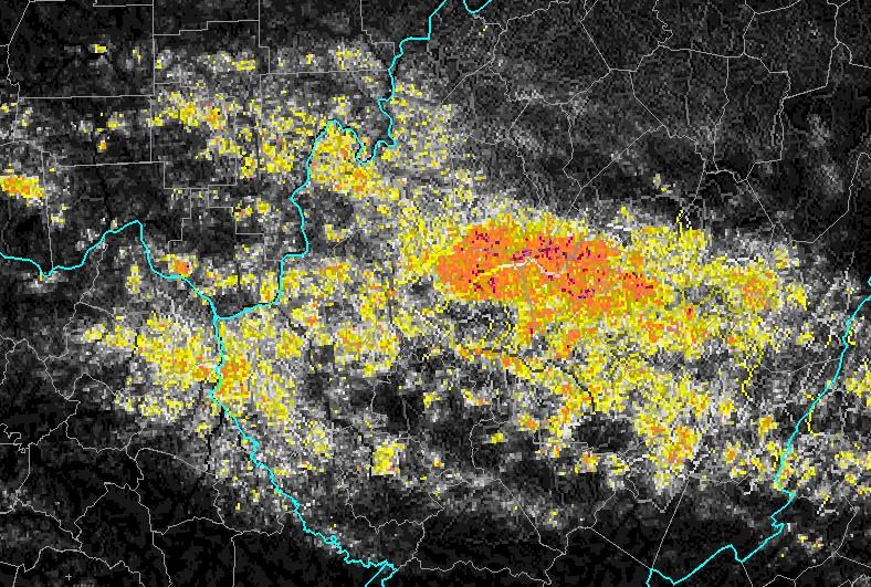
 MRMS Radar-Only")


4 Simulated surface water flows and return period 250 mm June 2010: Albert Pike Recreation Area, Arkansas Global Flood Partnership 2017 Conference 20 casualties Tuscaloosa, Alabama FLASH Stormscale Distributed Hydrologic Model Framework (1km2, 10 min) MRMS Radar-Only QPE (1 km2, 2 min) High Spatiotemporal Resolution Output Using MRMS and FLASH June 2017 Forecast lead time = 12 hr Spatial Resolution = 0.01 deg Frequency = 2-10 min Latency = 6-8 min Variable = Q, unit Q Type = probability of impact Coverage = U.S. 4

5 From Martinaitis et al Marginal event in an urban setting Global Flood Partnership 2017 Conference Tuscaloosa, Alabama June

6 Model tuning using local storm reports Minor flash Flooding > 1 Catastrophic flash Flooding > 10 Histogram of reforecast unit discharge values for reported flash flood events Threshold ~1-2 cms/km 2 identified as lower bound Values > 10 cms/km 2 associated to catastrophic flash floods 6


7 2. Conventional Discharge Estimation 7400 gaged locations; 9800 ungaged watersheds $15k hardware; $15k/yr O&M Most gages measure stage; want discharge STAGE (ft) DISCHARGE (cfs) Conventional method: 1. Read stage reported by gage 2. Manually measure discharge 3. Repeat for various stages to develop rating curve Problems: Labor-intensive Can only interpolate within measured range Rating may be hysteretic Streambed changes alter rating


8 Model validation of peak flow and peak timing using conventional streamgauge data Unit Peak Discharge Linear correlation = 0.64 Rank correlation = 0.79 Timing of Peak Discharge Gourley et al., 2017, BAMS 1837 unregulated basins Drainage < 1000 km 2 Oct 2002 to Sep min/1 km hindcast with MRMS radarbased forcing > 80% of basin area with 1km radar coverage Snow contribution < 30% of annual precip 88,241 significant flow events 8


9 Direct Discharge Calculation Goal: Calculate discharge from directly-measured variables, using only non-contact sensors Does away with rating curve Prevents hysteresis error Decreases deployment time Decreases lifecycle cost Water stage $18k hardware; ~3k/yr O&M Discharge: Channel bathymetry Stream velocity (v) Q=vA Global Flood Partnership 2017 Conference Tuscaloosa, Alabama Cross-sectional area (A) June 2017


10 Gaging With Stage/Velocity Radars Simplified infrastructure No gage house, stilling well, or underwater plumbing Carry on foot and deploy in one day Adaptive data logging Increase logging/transmitting frequency as stage/velocity increase Emergency SMS notifications for flood events


11 Fall s Creek Summer Camp 65,000 visitors over a 10-week period in summer As many as 7500 campers on site at a given time Velocity increases 1h prior to stage rise River stage went from 2 ft to 12 ft in 1 hour
12 3. Impact databases from nonconventional sources mping meteorological Phenomena Identification Near the Ground A free citizen science app for reporting weather impacts at user s location Flood severity levels Basic 4 tiered scale Minor, Moderate, Serious, Severe Crowdsourced FF reports High-resolution spatial representation
13 Customizing EF5 for Railroad Track Impacts A total of 461 Reports between 05/15 and 01/ FLASH pixels (i.e. unit q values) There are 7 broad categories: Washout 288 instances (28.86%) Side Wash 279 instances (27.96%) High Water 216 instances (21.64%) Flood Wash 155 instances (15.53%) Embankment 21 instances (2.10%) Flooding 39 instances (3.91%) Mudslide 1 instance (0.10%) 13


14 Examples of track impacts 14

15 Development of products to forecast track impacts Real Data Probability of track impact Model 15


16 Machine learning algorithm for forecasting road flooding hazards Database of road flooding (Gourley et al., BAMS, 2013) Probability of impacts from road flooding 16
17 Discussion Points/Questions for flash flood observations 1. What kinds of impact databases are available? 2. What is their period of record and areal coverage? 3. Are they publicly available or is there a fee? 4. What is the role of emerging remote-sensing datasets? Space-based: Optical channels, passive microwave, active microwave Drones Velocity increases 1h prior to stage rise River stage went from 2 ft to 12 ft in 1 hour 17
Michael Schaffner, Alexander Tardy, Jayme Laber, Carl Unkrich, and David Goodrich,
 Michael Schaffner, Alexander Tardy, Jayme Laber, Carl Unkrich, and David Goodrich, A collaborative effort between NWS Western Region Headquarters, NWS San Diego, NWS Oxnard, and the USDA-ARS Southwest
Arkansas-Red Basin River Forecast Center Operations. RRVA Conference Durant, OK 8/22/2013 Jeff McMurphy Sr. Hydrologist - ABRFC
 Arkansas-Red Basin River Forecast Center Operations RRVA Conference Durant, OK 8/22/2013 Jeff McMurphy Sr. Hydrologist - ABRFC NWS River Forecast Centers NWS Weather Forecast Offices Operations Staffing
Operational Perspectives on Hydrologic Model Data Assimilation
 Operational Perspectives on Hydrologic Model Data Assimilation Rob Hartman Hydrologist in Charge NOAA / National Weather Service California-Nevada River Forecast Center Sacramento, CA USA Outline Operational
CASA WX DFW URBAN DEMONSTRATION NETWORK
 CASA WX DFW URBAN DEMONSTRATION NETWORK Goals Background on Regional CASA WX Project Explain the capabilities, structure of the Radar Network Present the CASA WX DFW Test Bed will be rolled out Describe
Flash Flood Guidance System On-going Enhancements
 Flash Flood Guidance System On-going Enhancements Hydrologic Research Center, USA Technical Developer SAOFFG Steering Committee Meeting 1 10-12 July 2017 Jakarta, INDONESIA Theresa M. Modrick Hansen, PhD
Surface Hydrology Research Group Università degli Studi di Cagliari
 Surface Hydrology Research Group Università degli Studi di Cagliari Evaluation of Input Uncertainty in Nested Flood Forecasts: Coupling a Multifractal Precipitation Downscaling Model and a Fully-Distributed
An Overview of Operations at the West Gulf River Forecast Center Gregory Waller Service Coordination Hydrologist NWS - West Gulf River Forecast Center
 National Weather Service West Gulf River Forecast Center An Overview of Operations at the West Gulf River Forecast Center Gregory Waller Service Coordination Hydrologist NWS - West Gulf River Forecast
United States Multi-Hazard Early Warning System
 United States Multi-Hazard Early Warning System Saving Lives Through Partnership Lynn Maximuk National Weather Service Director, Central Region Kansas City, Missouri America s s Weather Enterprise: Protecting
Radar Network for Urban Flood and Severe Weather Monitoring
 Radar Network for Urban Flood and Severe Weather Monitoring V. Chandrasekar 1 and Brenda Philips 2 Colorado State University, United States University of Massachusetts, United States And the full DFW team
Model Calibration and Forecast Error for NFIE-Hydro
 Corey Van Dyk C E 397 Flood Forecasting 5/8/15 Model Calibration and Forecast Error for NFIE-Hydro Introduction The forecasting component of the National Flood Interoperability Experiment (NFIE), like
USGS Hydrography Overview. May 9, 2018
 + 1 USGS Hydrography Overview May 9, 2018 + 2 The National Geospatial Program Provides the geospatial baseline of the Nation s topography, natural landscape and built environment through The National Map,
FFGS Advances. Initial planning meeting, Nay Pyi Taw, Myanmar February, Eylon Shamir, Ph.D,
 FFGS Advances Initial planning meeting, Nay Pyi Taw, Myanmar 26-28 February, 2018 Eylon Shamir, Ph.D, EShamir@hrcwater.org Hydrologic Research Center San Diego, California FFG System Enhancements The following
Thunderstorm Forecasting and Warnings in the US: Applications to the Veneto Region
 Thunderstorm Forecasting and Warnings in the US: Applications to the Veneto Region Bill Conway Vice President Weather Decision Technologies Norman, Oklahoma, USA Andrea Rossa ARPAV Lead Scientist Centre
Operational Hydrologic Ensemble Forecasting. Rob Hartman Hydrologist in Charge NWS / California-Nevada River Forecast Center
 Operational Hydrologic Ensemble Forecasting Rob Hartman Hydrologist in Charge NWS / California-Nevada River Forecast Center Mission of NWS Hydrologic Services Program Provide river and flood forecasts
CLIMATE CHANGE ADAPTATION BY MEANS OF PUBLIC PRIVATE PARTNERSHIP TO ESTABLISH EARLY WARNING SYSTEM
 CLIMATE CHANGE ADAPTATION BY MEANS OF PUBLIC PRIVATE PARTNERSHIP TO ESTABLISH EARLY WARNING SYSTEM By: Dr Mamadou Lamine BAH, National Director Direction Nationale de la Meteorologie (DNM), Guinea President,
13.2 USING VIRTUAL GLOBES TO IMPROVE SITUATIONAL AWARENESS IN THE NATIONAL WEATHER SERVICE
 13.2 USING VIRTUAL GLOBES TO IMPROVE SITUATIONAL AWARENESS IN THE NATIONAL WEATHER SERVICE Andy Foster* National Weather Service Springfield, Missouri* Keith Stellman National Weather Service Shreveport,
Flood Forecasting Methods and Models Calgary, Alberta February 19, 2014
 Flood Forecasting Methods and Models Calgary, Alberta February 19, 2014 Why Am I Here? Why Am I Here? It s Winter Olympics time! Colorado is the home of such athletes as Lindsey Vonn, Todd Lodwick, Mikaela
Complete Weather Intelligence for Public Safety from DTN
 Complete Weather Intelligence for Public Safety from DTN September 2017 White Paper www.dtn.com / 1.800.610.0777 From flooding to tornados to severe winter storms, the threats to public safety from weather-related
Regional Flash Flood Guidance and Early Warning System
 WMO Training for Trainers Workshop on Integrated approach to flash flood and flood risk management 24-28 October 2010 Kathmandu, Nepal Regional Flash Flood Guidance and Early Warning System Dr. W. E. Grabs
Speakers: NWS Buffalo Dan Kelly and Sarah Jamison, NERFC Jeane Wallace. NWS Flood Services for the Black River Basin
 Speakers: NWS Buffalo Dan Kelly and Sarah Jamison, NERFC Jeane Wallace NWS Flood Services for the Black River Basin National Weather Service Who We Are The National Oceanic and Atmospheric Administration
Overview of Data for CREST Model
 Overview of Data for CREST Model Xianwu Xue April 2 nd 2012 CREST V2.0 CREST V2.0 Real-Time Mode Forcasting Mode Data Assimilation Precipitation PET DEM, FDR, FAC, Slope Observed Discharge a-priori parameter
Haiti and Dominican Republic Flash Flood Initial Planning Meeting
 Dr Rochelle Graham Climate Scientist Haiti and Dominican Republic Flash Flood Initial Planning Meeting September 7 th to 9 th, 2016 Hydrologic Research Center http://www.hrcwater.org Haiti and Dominican
A Cloud-Based Flood Warning System For Forecasting Impacts to Transportation Infrastructure Systems
 A Cloud-Based Flood Warning System For Forecasting Impacts to Transportation Infrastructure Systems Jon Goodall Associate Professor, Civil and Environmental Engineering Associate Director, Link Lab April
The use of SHAVE and NWS flash flood reports for impact characterization and prediction
 EGU Vienna Flash Flood Session April 25th 2012 The use of SHAVE and NWS flash flood reports for impact characterization and prediction Martin Calianno Work carried out during my Master of Sc. Thesis, in
Add NOAA nowcoast Layers to Maps
 WebEOC Maps Add-on Quick Reference Guide Add NOAA nowcoast Layers to Maps Overview With Maps Add-on, you can configure an unlimited number of map layers. These layers allow you to control the data you
Guide to Hydrologic Information on the Web
 NOAA s National Weather Service Guide to Hydrologic Information on the Web Colorado River at Lees Ferry Photo: courtesy Tim Helble Your gateway to web resources provided through NOAA s Advanced Hydrologic
GIS Techniques for Floodplain Delineation. Dean Djokic
 GIS Techniques for Floodplain Delineation Dean Djokic (ddjokic@esri.com) Content What is a floodplain? How to get a floodplain? What can GIS do for floodplain modeling? Simple GIS techniques for floodplain
Rainfall-River Forecasting: Overview of NOAA s Role, Responsibilities, and Services
 Dr. Thomas Graziano Chief Hydrologic Services Division NWS Headquarters Steve Buan Service Coordination Hydrologist NWS North Central River Forecast Center Rainfall-River Forecasting: Overview of NOAA
Remote Sensing of River Discharge to Expand the USGS Streamgaging Network
 Remote Sensing of River Discharge to Expand the USGS Streamgaging Network Dave Bjerklie, John Fulton, Robert Mason, John Jones United States Geological Survey Charon Birkett, University of Maryland ESSIC
Hurricane Harvey Flood Emergency Response
 Hot Science - Cool Talk # 114 Hurricane Harvey Flood Emergency Response Dr. David Maidment September 14, 2018 Produced by and for Hot Science - Cool Talks by the Environmental Science Institute. We request
National Flood Interoperability Experiment
 National Flood Interoperability Experiment David R. Maidment, University of Texas at Austin Catchment-based Hydrological Data Assimilation (CAHMDA) VI Conference 8 September 2014 Located on Tuscaloosa
CARFFG System Development and Theoretical Background
 CARFFG Steering Committee Meeting 15 SEPTEMBER 2015 Astana, KAZAKHSTAN CARFFG System Development and Theoretical Background Theresa M. Modrick, PhD Hydrologic Research Center Key Technical Components -
Robert Shedd Northeast River Forecast Center National Weather Service Taunton, Massachusetts, USA
 Robert Shedd Northeast River Forecast Center National Weather Service Taunton, Massachusetts, USA Outline River Forecast Centers FEWS Implementation Status Forcing Data Ensemble Forecasting The Northeast
Lessons Learned and Shared
 Lessons Learned and Shared Plan for the worst. Hope for the best. Remember that hope is not a strategy. Agnes 8 Lessons 1. Identify Susceptible Communities 2. Develop a Plan 3. Threat Recognition 4. Review
Delaware River Flood Advisory Committee
 Delaware River Flood Advisory Committee A Partnership to Support Flood Mitigation Alan Tamm Pennsylvania Emergency Management Agency Bureau of Recovery and Mitigation atamm@state.pa.us Peter Gabrielsen
FFGS Additional Functionalities and Products. Konstantine P. Georgakakos, Sc.D. HYDROLOGIC RESEARCH CENTER 23 May 2018
 FFGS Additional Functionalities and Products Konstantine P. Georgakakos, Sc.D. HYDROLOGIC RESEARCH CENTER 23 May 2018 Advanced Functionalities 0. Multi-Model QPF A. Urban Flash Flood Warning B. Riverine
FLOOD REPORT FOR MANITOBA. June 28, A Gale wind warning is in effect for Lake Manitoba and Lake Winnipeg
 FLOOD REPORT FOR MANITOBA June 28, 2014 A Gale wind warning is in effect for Lake Manitoba and Lake Winnipeg Flood Warning*: Flood Watch*: High Water Advisory*: - Assiniboine River, from Shellmouth Dam
National Weather Service. Harold H. Opitz Hydrologist in Charge
 National Weather Service Harold H. Opitz Hydrologist in Charge Goals Organization Role of the River Forecast Center Describe Forecast System & Tools Other Details NWS River Forecast Centers Northwest River
Monitoring Scour Critical Bridges During Floods For Local Bridge Owners. Presented by
 Monitoring Scour Critical Bridges During Floods For Local Bridge Owners Presented by SAFETY FIRST DO NOT ENDANGER YOURSELF OR OTHERS WHILE MONITORING BRIDGES DO NOT ENTER FLOOD WATERS FLOOD WATERS INCLUDE
Aurora Bell*, Alan Seed, Ross Bunn, Bureau of Meteorology, Melbourne, Australia
 15B.1 RADAR RAINFALL ESTIMATES AND NOWCASTS: THE CHALLENGING ROAD FROM RESEARCH TO WARNINGS Aurora Bell*, Alan Seed, Ross Bunn, Bureau of Meteorology, Melbourne, Australia 1. Introduction Warnings are
Real-Time Meteorological Gridded Data: What s New With HEC-RAS
 Real-Time Meteorological Gridded Data: What s New With HEC-RAS Acquisition and Application of Gridded Meteorological Data in Support of the USACE s Real-Time Water Management Mission Fauwaz Hanbali, Tom
CENTRAL TEXAS HILL COUNTRY FLOOD
 CENTRAL TEXAS HILL COUNTRY FLOOD Term project report DECEMBER 7, 2018 UNIVERSITY OF TEXAS AT AUSTIN CE394K: GIS in Water Resources Engineering RIFAAI Mohamed Talha Table of Contents Introduction... 3 Context...
*Corresponding author address: Charles Barrere, Weather Decision Technologies, 1818 W Lindsey St, Norman, OK
 P13R.11 Hydrometeorological Decision Support System for the Lower Colorado River Authority *Charles A. Barrere, Jr. 1, Michael D. Eilts 1, and Beth Clarke 2 1 Weather Decision Technologies, Inc. Norman,
Storm Report : September 27, 2014
 True-color Visible Satellite, Sep. 27, 2014 2:00 PM MST Flood Control District of Maricopa County Engineering Division, Flood Warning Branch Storm Report : September 27, 2014 Initial Release: 10/10/2014
A Simple Data-Driven Model for Streamflow Prediction
 A Simple Data-Driven Model for Streamflow Prediction Valliappa Lakshmanan 1,2, Jonathan J. Gourley 2,Zac Flamig 1,2,Scott Giangrande 3 Abstract It is sometimes useful to create a statistical model to simulate
The Hydrologic Cycle: How Do River Forecast Centers Measure the Parts?
 The Hydrologic Cycle: How Do River Forecast Centers Measure the Parts? Greg Story Meteorologist National Weather Service Fort Worth, TX Overview n Introduction What is the mission of an RFC? n The Hydrologic
Final Report. COMET Partner's Project. University of Texas at San Antonio
 Final Report COMET Partner's Project University: Name of University Researcher Preparing Report: University of Texas at San Antonio Dr. Hongjie Xie National Weather Service Office: Name of National Weather
What s New in Topographic Information - USGS National Map
 + What s New in Topographic Information - USGS National Map SARGIS Workshop November 14, 2016 Rob Dollison, 703-648-5724 rdollison@usgs.gov + USGS 2 National Geospatial Program The National Geospatial
CW3E Atmosphere River Update - Summary
 CW3E Atmosphere River Update - Summary Two Atmospheric Rivers (ARs) made landfall over the Pacific Northwest over the previous four days These events combined to produce >400 mm of precipitation in southern
Floodplain Mapping & Flood Warning Applications in North Carolina
 Floodplain Mapping & Flood Warning Applications in North Carolina Marc Stanard, IT Project Manager Ken Ashe, Assistant Director David Herlong, Flood Warning Program Manager NC Crime Control & Public Safety
Emerging Aviation Weather Research at MIT Lincoln Laboratory*
 Emerging Aviation Weather Research at MIT Lincoln Laboratory* Haig 19 November 2015 *This work was sponsored by the Federal Aviation Administration under Air Force Contract No. FA8721-05-C-0002. Opinions,
Hydrology and Hydraulics Design Report. Background Summary
 To: National Park Services Montezuma Castle National Monument Richard Goepfrich, Facility Manager From: Multicultural Technical Engineers Date: Tuesday - February 13, 2018 Subject: 30% Hydrology and Hydraulics
Linking the Hydrologic and Atmospheric Communities Through Probabilistic Flash Flood Forecasting
 Linking the Hydrologic and Atmospheric Communities Through Probabilistic Flash Flood Forecasting Wallace Hogsett Science and Operations Officer NOAA/NWS/Weather Prediction Center with numerous contributions
Convection Nowcasting Products Available at the Army Test and Evaluation Command (ATEC) Ranges
 Ranges") Convection Nowcasting Products Available at the Army Test and Evaluation Command (ATEC) Ranges Cathy Kessinger National Center for Atmospheric Research (NCAR), Boulder, CO with contributions from: Wiebke
Convection Nowcasting Products Available at the Army Test and Evaluation Command (ATEC) Ranges Cathy Kessinger National Center for Atmospheric Research (NCAR), Boulder, CO with contributions from: Wiebke
Daily Operations Briefing Tuesday, April 4, :30 a.m. EDT
 Daily Operations Briefing Tuesday, April 4, 2017 8:30 a.m. EDT Significant Activity Apr 3-4 Significant Events: Severe Weather Southern Plains to Southeast Significant Weather: Severe Thunderstorms and
Enhancements for FFGS improved operations
 Enhancements for FFGS improved operations Hydrologic Research Center 3-5 May 2017 3-5 May 2017 HRC CAFFG 1 Enhancements to be discussed A. Multiple Mesoscale Model Input B. Urban Flash Flood Warning C.
Transportation and Road Weather
 Portland State University PDXScholar TREC Friday Seminar Series Transportation Research and Education Center (TREC) 4-18-2014 Transportation and Road Weather Rhonda Young University of Wyoming Let us know
Flood Hazard Inundation Mapping. Presentation. Flood Hazard Mapping
 Flood Hazard Inundation Mapping Verne Schneider, James Verdin, and JeradBales U.S. Geological Survey Reston, VA Presentation Flood Hazard Mapping Requirements Practice in the United States Real Time Inundation
PENNSYLVANIA DEPARTMENT OF TRANSPORTATION ENGINEERING DISTRICT 3-0
 PENNSYLVANIA DEPARTMENT OF TRANSPORTATION ENGINEERING DISTRICT 3-0 LYCOMING COUNTY S.R.15, SECTION C41 FINAL HYDROLOGIC AND HYDRAULIC REPORT STEAM VALLEY RUN STREAM RELOCATION DATE: June, 2006 REVISED:
Dr. Amanda Schroeder. NWS Weather Forecast Office Fort Worth, TX. Sustainable Urban Water Workshop University of Texas-Arlington June 4-5, 2015
 Dr. Amanda Schroeder NWS Weather Forecast Office Fort Worth, TX Sustainable Urban Water Workshop University of Texas-Arlington June 4-5, 2015 Outline Communicating the message - official Flood and Flash
QPE and QPF in the Bureau of Meteorology
 QPE and QPF in the Bureau of Meteorology Current and future real-time rainfall products Carlos Velasco (BoM) Alan Seed (BoM) and Luigi Renzullo (CSIRO) OzEWEX 2016, 14-15 December 2016, Canberra Why do
Landslide monitoring system in Iceland. Harpa Grímsdóttir Jón Kristinn Helgason NVE, Oslo, October
 Landslide monitoring system in Iceland Harpa Grímsdóttir Jón Kristinn Helgason NVE, Oslo, October 26 2016 History Avalanches and landslides have caused extensive damages and loss of human lives in Iceland
Significant Flooding Expected
 Significant Flooding Expected Decision Support Briefing #5 As of: 9:00 AM September 14, 2018 What Has Changed? Flash Flood Watch now in effect for part of area, will be expanded later today 9/14/2018 9:23
FROM FLOOD FORECAST TO FLOOD FIGHTING Georg Johann , Tiel
 FROM FLOOD FORECAST TO FLOOD FIGHTING Georg Johann 2016-11-04, Tiel Dutch-German exchange of knowledge and experience COMING FROM FORECASTS TO EFFECTIVE FLOOD DEFENDING EMERGENCY MEASURES Flood forecasting
Attachment B to Technical Memorandum No.2. Operations Plan of Ross Valley Detention Basins
 Attachment B to Technical Memorandum No.2 Operations Plan of Ross Valley Detention Basins Operations Plan of Ross Valley Detention Basins Stetson Engineers Inc. January 26, 2011 1.0 Introduction Achieving
Effective Utilization of Synthetic Aperture Radar (SAR) Imagery in Rapid Damage Assessment
 Imagery in Rapid Damage Assessment") Effective Utilization of Synthetic Aperture Radar (SAR) Imagery in Rapid Damage Assessment Case Study Pakistan Floods SUPARCO M. Maisam Raza, Ahmad H. Rabbani SEQUENCE Flood Monitoring using Satellite
Effective Utilization of Synthetic Aperture Radar (SAR) Imagery in Rapid Damage Assessment Case Study Pakistan Floods SUPARCO M. Maisam Raza, Ahmad H. Rabbani SEQUENCE Flood Monitoring using Satellite
System Validation. SEEFFG Operations Workshop. Theresa M. Modrick, PhD Hydrologic Engineer Hydrologic Research Center
 SEEFFG Operations Workshop System Validation Theresa M. Modrick, PhD Hydrologic Engineer Hydrologic Research Center TModrick@hrcwater.org 09 May 2016 1 Fundamental Concepts for Flash Flood Guidance FFG
BARON END-TO-END HYDROLOGICAL MODELING SOLUTION NOW AVAILABLE IN NEW BARON LYNX DISPLAY
 4930 Research Drive Huntsville, AL 35805 (256)-881-8811 www.baronweather.com FOR IMMEDIATE RELEASE BARON END-TO-END HYDROLOGICAL MODELING SOLUTION NOW AVAILABLE IN NEW BARON LYNX DISPLAY Powerful scientific
FEMA Hazards Loss Modeling Task Force (MOTF) Situation Report #14. Colorado Spring Flood Risk ***FINAL REPORT***
 Situation Report #14. Colorado Spring Flood Risk ***FINAL REPORT***") FEMA Hazards Loss Modeling Task Force (MOTF) Situation Report #14 Colorado Spring Flood Risk FEMA Modeling Task Force (MOTF) Denver Federal Center, Building 710A Denver, Colorado 80225 Email: FEMA-MOTF@fema.dhs.gov
FEMA Hazards Loss Modeling Task Force (MOTF) Situation Report #14 Colorado Spring Flood Risk FEMA Modeling Task Force (MOTF) Denver Federal Center, Building 710A Denver, Colorado 80225 Email: FEMA-MOTF@fema.dhs.gov
Charles Kuster Leadville, CO. Personal Overview
 Charles Kuster Leadville, CO Personal Overview Personal Overview Charles Kuster Leadville, CO OU to study meteorology Charles Kuster Leadville, CO Personal Overview OU to study meteorology Graduated in
Flooding in Manayunk Neighborhood of Philadelphia
 Flooding in Manayunk Neighborhood of Philadelphia Samuel Brodfuehrer GIS in Water Resources December 8, 2017 Introduction... 3 Philadelphia Overview... 3 Manayunk Overview... 4 Project Objective... 6 Methods
Global Flash Flood Forecasting from the ECMWF Ensemble
 Global Flash Flood Forecasting from the ECMWF Ensemble Calumn Baugh, Toni Jurlina, Christel Prudhomme, Florian Pappenberger calum.baugh@ecmwf.int ECMWF February 14, 2018 Building a Global FF System 1.
ENVG/SC 10110L-20110L PLANET EARTH LABORATORY. Laboratory #9: Surface Hydrology & Map Scale
 Name: Lab day: Tuesday Wednesday ENVG/SC 10110L-20110L PLANET EARTH LABORATORY Laboratory #9: Surface Hydrology & Map Scale Readings: Chapter 9. http://www.nd.edu/~cneal/physicalgeo/lab-surfacehydrology/index.html
USING GIS TO MODEL AND ANALYZE HISTORICAL FLOODING OF THE GUADALUPE RIVER NEAR NEW BRAUNFELS, TEXAS
 USING GIS TO MODEL AND ANALYZE HISTORICAL FLOODING OF THE GUADALUPE RIVER NEAR NEW BRAUNFELS, TEXAS ASHLEY EVANS While the state of Texas is well-known for flooding, the Guadalupe River Basin is one of
Preparing a NFIE-Geo Database for Travis County
 Preparing a NFIE-Geo Database for Travis County By David R. Maidment Center for Research in Water Resources University of Texas at Austin 2 February 2015 Contents Introduction... 1 Step 1. Download and
Haiti-Dominican Republic Flash Flood Guidance (HDRFFG) System: Development of System Products
 System: Development of System Products") Haiti-Dominican Republic Flash Flood Guidance (HDRFFG) System: Development of System Products Theresa M. Modrick, PhD Hydrologic Research Center HDRFFG Initial Planning Meeting 07-09 Sep 2015 Santo Domingo,
Haiti-Dominican Republic Flash Flood Guidance (HDRFFG) System: Development of System Products Theresa M. Modrick, PhD Hydrologic Research Center HDRFFG Initial Planning Meeting 07-09 Sep 2015 Santo Domingo,
Storm Surge/Coastal Inundation State of the Union. Jamie Rhome Storm Surge Team Lead NOAA/National Hurricane Center
 Storm Surge/Coastal Inundation State of the Union Jamie Rhome Storm Surge Team Lead NOAA/National Hurricane Center 2 Tampa: Cat 5 Scenario 3 4 The Stakes are High Combination of SLR and increasing coastal
Integrating Weather Forecasts into Folsom Reservoir Operations
 Integrating Weather Forecasts into Folsom Reservoir Operations California Extreme Precipitation Symposium September 6, 2016 Brad Moore, PE US Army Corps of Engineers Biography Brad Moore is a Lead Civil
NATIONAL WATER RESOURCES OUTLOOK
 NATIONAL WATER RESOURCES OUTLOOK American Meteorological Society Annual Meeting 24 th Hydrology Conference 9.2 James Noel Service Coordination Hydrologist National Weather Service-Ohio River Forecast Center
Incorporation of SMOS Soil Moisture Data on Gridded Flash Flood Guidance for Arkansas Red River Basin
 Incorporation of SMOS Soil Moisture Data on Gridded Flash Flood Guidance for Arkansas Red River Basin Department of Civil and Environmental Engineering, The City College of New York, NOAA CREST Dugwon
Areal Reduction Factors for the Colorado Front Range and Analysis of the September 2013 Colorado Storm
 Areal Reduction Factors for the Colorado Front Range and Analysis of the September 2013 Colorado Storm Doug Hultstrand, Bill Kappel, Geoff Muhlestein Applied Weather Associates, LLC - Monument, Colorado
NOAA s National Weather Service. National Weather Service
 NOAA s National Weather Service Serving the Nation s Environmental Forecasting Needs Lynn Maximuk Regional Director National Weather Service Central Region Headquarters Kansas City, Missouri America s
Management of Natural and Environmental Resources for Sustainable Agricultural Development
 World Meteorological Organization (WMO) Management of Natural and Environmental Resources for Sustainable Agricultural Development Use of the Object Modeling System for Operational Water Supply Forecasting
APPLICATIONS OF DOWNSCALING: HYDROLOGY AND WATER RESOURCES EXAMPLES
 APPLICATIONS OF DOWNSCALING: HYDROLOGY AND WATER RESOURCES EXAMPLES Dennis P. Lettenmaier Department of Civil and Environmental Engineering For presentation at Workshop on Regional Climate Research NCAR
StreamStats: Delivering Streamflow Information to the Public. By Kernell Ries
 StreamStats: Delivering Streamflow Information to the Public By Kernell Ries U.S. Department of the Interior U.S. Geological Survey MD-DE-DC District 410-238-4317 kries@usgs.gov StreamStats Web Application
for Emergency System in the Czech Republic Ivan Obrusník Czech Hydrometeorological Institute
 Multi-Hazard Warning Service for Emergency System in the Czech Republic Ivan Obrusník Czech Hydrometeorological Institute Catastrophic Flood 2002 Prague Catastrophic flood 1997 in Moravia Flood the main
LOMR SUBMITTAL LOWER NEHALEM RIVER TILLAMOOK COUNTY, OREGON
 LOMR SUBMITTAL LOWER NEHALEM RIVER TILLAMOOK COUNTY, OREGON Prepared for: TILLAMOOK COUNTY DEPARTMENT OF COMMUNITY DEVELOPMENT 1510-B THIRD STREET TILLAMOOK, OR 97141 Prepared by: 10300 SW GREENBURG ROAD,
Use of Snow Data from Remote Sensing in Operational Streamflow Prediction
 Use of Snow Data from Remote Sensing in Operational Streamflow Prediction Stacie Bender 1, Thomas H. Painter 2, Paul Miller 1, Michelle Stokes 1 1 NOAA/National Wear Service Colorado Basin River Forecast
MODERN TECHNOLOGIES IN HYDRO-METEOROLOGICAL INFORMATION SYSTEMS
 MODERN TECHNOLOGIES IN HYDRO-METEOROLOGICAL INFORMATION SYSTEMS MARK HEGGLI, INNOVATIVE HYDROLOGY CONSULTING METEOROLOGIST/HYDROLOGIST TO THE WORLD BANK AREAS OF TECHNOLOGY ADVANCEMENT RECENT TECHNOLOGY
Flood Forecasting in Bangladesh
 Flood Forecasting in Bangladesh Types of Flood ing Flood ing can be divided into two categories: Flood ing in the rivers caused by upstream rise of river stage as well as rainfall in the basin. Overland
Folsom Dam Water Control Manual Update
 Folsom Dam Water Control Manual Update Public Workshop April 3, 2014 Location: Sterling Hotel Ballroom 1300 H Street, Sacramento US Army Corps of Engineers BUILDING STRONG WELCOME & INTRODUCTIONS 2 BUILDING
Squaw Creek. General Information
 General Information is a tributary to the Salmon River. It enters the north side of the river about 0 miles downstream of North Fork, Idaho. The study reach is about a 30 ft length of stream about 2 miles
WMO/WWRP FDP: INCA CE
 WMO/WWRP FDP: INCA CE Yong Wang ZAMG, Austria This project is implemented through the CENTRAL EUROPE Programme co-financed by the ERDF INCA CE: implementation over Central Europe A Nowcasting Initiative
Overview of a Changing Climate in Rhode Island
 Overview of a Changing Climate in Rhode Island David Vallee, Hydrologist in Charge, National Weather Service Northeast River Forecast Center, NOAA Lenny Giuliano, Air Quality Specialist, Rhode Island Department
ESTIMATING JOINT FLOW PROBABILITIES AT STREAM CONFLUENCES USING COPULAS
 ESTIMATING JOINT FLOW PROBABILITIES AT STREAM CONFLUENCES USING COPULAS Roger T. Kilgore, P.E., D. WRE* Principal Kilgore Consulting and Management 2963 Ash Street Denver, CO 80207 303-333-1408 David B.
USA National Weather Service Community Hydrologic Prediction System
 USA National Weather Service Community Hydrologic Prediction System Rob Hartman Hydrologist in Charge NOAA / National Weather Service California-Nevada River Forecast Center Sacramento, CA Background Outline
FFGS Concept HYDROLOGIC RESEARCH CENTER. 2 May 2017
 FFGS Concept HYDROLOGIC RESEARCH CENTER 2 May 2017 Research and Development History 1970-1988: US NWS Produces FFG statistically for each River Forecast Center. Also, research in adaptive site specific
A Near Real-time Flood Prediction using Hourly NEXRAD Rainfall for the State of Texas Bakkiyalakshmi Palanisamy
 A Near Real-time Flood Prediction using Hourly NEXRAD for the State of Texas Bakkiyalakshmi Palanisamy Introduction Radar derived precipitation data is becoming the driving force for hydrological modeling.
Caribbean Early Warning System Workshop
 Caribbean Early Warning System Workshop Hamonization in Existing EWS April 14-16, 2016 Presenter: Shawn Boyce Caribbean Institute for Meteorology and Hydrology Husbands, St. James Barbados Background Between
Hydrological forecasting and decision making in Australia
 Hydrological forecasting and decision making in Australia Justin Robinson, Jeff Perkins and Bruce Quig Bureau of Meteorology, Australia The Bureau's Hydrological Forecasting Services Seasonal Forecasts