Haiti-Dominican Republic Flash Flood Guidance (HDRFFG) System: Development of System Products
|
|
|
- Stephen Brooks
- 5 years ago
- Views:
Transcription
1 Haiti-Dominican Republic Flash Flood Guidance (HDRFFG) System: Development of System Products Theresa M. Modrick, PhD Hydrologic Research Center HDRFFG Initial Planning Meeting Sep 2015 Santo Domingo, DR

2 HDRFFG System Products 1. Observed Precipitation 2. Hydrologic State 3. Forecast Precipitation 2
 over each watershed.")
3 HDRFFG System Products: Precipitation OBSERVED PRECIPITATION: How much precipitation has fallen MAP: Mean areal precipitation The average precipitation (observed or forecast) over each watershed. 3


4 HDRFFG System Products: Precipitation FORECAST PRECIPITATION: How much precipitation is expected based on NWP model QPF. 4
5 HDRFFG System Products 1. Observed Precipitation 2. Hydrologic State 3. Forecast Precipitation 5
6 Why is Soil Moisture Important? Georgakakos et al., WRR 31(3), ,
7 ASM: Average Soil Moisture Key Definitions An estimate of the level of saturation (fraction) in the upper soil layer. This is computed by the model. Forecasters may see changes as precipitation falls and basins (or groups of basins) become more saturated. 7
8 Key Definitions Flash Flood Guidance (FFG): The amount of rainfall of a given duration and over a given catchment that is just enough to cause bankfull conditions at the outlet of the draining stream FFG Bankfull Flow: flow level in stream associated with the transition from main/active channel to overbank or flood plain. This is level of initiation of flooding (not necessarily damage level). Bankfull Flow 8
9 HDRFFG System Products Flash Flood Threat (FFT): System computed difference between the MAP and FFG values. 9
10 Key Technical Components for Flash Flood Guidance Systems Real-time Precipitation Input Satellite Rainfall Radar (as available) Gauge (as available) Rainfall Data Processing Quality Control Merging Bias Adjustment Snow Model Snow Cover Temperature Flash Flood Guidance Model Soil Moisture Model Evapotranspiration (Climatological) Flash Flood Guidance Threshold Runoff Model Forecaster Input Flash Flood Threat Rainfall Forecasts (Mesoscale Model) Spatial GIS Data Analysis Basin Delineation Parameter Estimation (Terrain, LULC, Soils) 1010
11 HDRFFG System Products Flash Flood Guidance Systems need up-to-date high-quality estimates of precipitation to assess current flash flood potential. 11
 provide ground truth but often have sparse coverage.")
12 Satellite Precipitation HydroEstimator (GHE) Remotely-sensed precipitation estimates provide good spatial coverage and detail. In situ observations (rain gauges) provide ground truth but often have sparse coverage. NOAA/NESDIS Hydro-Estimator 24-hr rainfall ending 12 UTC Satellite estimates since late 1970s; Hydro-Estimator since 2002; GHE operational in Provide critical data in data sparse regions! Infrared (IR) based (10.7 µm) **Short latency**(< ½ hour) ~4 km resolution GHE: Rainfall rate based on Cloud Top Brightness Temperature (indirect measurement) 12

13 Multi-Spectral Satellite Precipitation for FFG Systems CMORPH is based on measurements of microwave scattering from raindrops. - measure of the hydrometeors in clouds - still not observation of rainfall at surface - ~8 km resolution hr latency in operations 13
 up to last CMORPH observation, (b) develops an adjustment factor based on differences within region, (c) applies adjustment to GHE up to current observation.")
14 Multi-Spectral Satellite Precipitation for FFG Systems HRC effort to combine IR-based GHE rainfall with MW-based CMORPH rainfall HRC-developed method which: (a) compares IR-based GHE and MW-based CMORPH for period (2-3 days) up to last CMORPH observation, (b) develops an adjustment factor based on differences within region, (c) applies adjustment to GHE up to current observation. FFGS Product MWGHE Example from South East Europe (SEEFFGS) 14

15 Merged MAP Product Example from Black Sea Middle East (BSMEFFGS) Merged MAP is the best estimate of Mean Areal Precipitation over each small watershed for previous 1-, 3-, 6- and 24- hour periods. - Satellite - Real-time gauges - Radar (if available) * Includes bias adjustment 15
16 Bias Adjustment for Satellite Precipitation Bias may exist in the remotely sensed precipitation estimates relative to gauges. Bias should be removed before inputting to hydrologic models. Vastly different scales of satellite pixel and rain gauge area Orography organizes surface rainfall according to prevailing winds Satellite estimates do not directly measure rainfall at surface There may be significant misregistration errors in satellite data Satellite Pixel, R SAT Raingauge, R G (xo,yo) 16
17 Bias Adjustment for Satellite Precipitation REGION A Sat Pixel 1 Gauge 1 Region 3 (Adriatic Coastal) Wet Season # Gauge/Pixel Pairs = 36 Gauge 2 Sat Pixel 2 Sat Pixel 3 Gauge 3 Sat Pixel N Gauge N Log Bias: ββ tt = ln NN GG jj=1 RR GG jj, tt /NNNN NN GG jj=1 RR SSSSSS jj, tt /NNNN Two bias adjustments may be made: climatological and real-time. 17
 Bias Factor computed from mean monthly values Bias Factor")
18 Climatological Bias Adjustment Considers long-term bias in satellite precipitation estimates based on historical data from satellite and raingauge network. Regions of uniform hydroclimatology, terrain and gauge density Analysis is done on monthly or seasonal basis (depending on data record) Bias Factor computed from mean monthly values Bias Factor computed based on probability matching We gather historical raingauge data to do initial analysis, then train forecasters to do this analysis, so they may repeat as additional years of data are available. 18
 Rs (, t j) Gauge data quality control is important!")
19 Dynamic Bias Adjustment Considers event (short-term) adjustment based on real-time gauge reports Employs Kalman Filter approach Minimum number of gauge/satellite pixel pairs reporting over consecutive time steps β t = n N g j= 1 N g j= 1 Rg (, t j) Rs (, t j) Gauge data quality control is important! β = β + w t t t z = β + v t t t Example from South East Europe (SEEFFGS) 19


20 Historical Analysis: Limited Gauges Bias Adjustment for HDRFFG Dynamic Bias Adjustment is disengaged as real-time stations are no longer reporting. 20
21 Key Technical Components for Flash Flood Guidance Systems Real-time Precipitation Input Satellite Rainfall Radar (as available) Gauge (as available) Rainfall Data Processing Quality Control Merging Bias Adjustment Snow Model Snow Cover Temperature Flash Flood Guidance Model Soil Moisture Model Evapotranspiration (Climatological) Flash Flood Guidance Threshold Runoff Model Forecaster Input Flash Flood Threat Rainfall Forecasts (Mesoscale Model) Spatial GIS Data Analysis Basin Delineation Parameter Estimation (Terrain, LULC, Soils) 2121


22 Need for Soil Water Accounting What happens after rain falls? Hydrologic Components of FFG System account for land surface processes in production of flash floods. infiltration of rainfall into soil and storage of soil water accumulation and ablation of snow, and snow melt contribution to soil production of runoff into channels evapotranspiration From BBC news 22
23 HDRFFG System Products Example from Black Sea Middle East (BSMEFFGS) 23
24 Soil Model for HDRFFG A conceptual hydrologic model is used for soil water modeling: Sacramento Soil Moisture Accounting Model (SAC-SMA) to estimate ability of land surface to absorb and hold moisture. A two-layer conceptual model representing the movement of soil water through a vertical, homogeneous soil column 24
25 Soil Model for HDRFFG Schematic of Sacramento SMA Model INPUT: Precipitation (or Rain+Snow melt) Potential Evapotranspiration Various representations of runoff: saturation excess infiltration excess combined runoff PARAMETERIZATION: 15 model parameters (capacities, withdrawal rates, percolation) Initial parameters based on soils and land cover 25

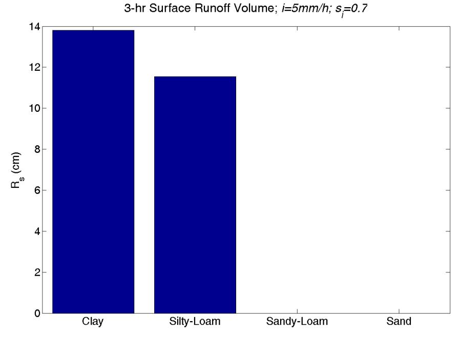
26 Effect of Soil Classification on Runoff Production 26


27 Relating Soils Characteristics to Hydraulic Properties Figures from Brady, N.C., 1974: The nature and properties of soils. McMillan Publ. Co., NY 27
 K s (m/h) α σ Ks (m/h) Sand 0.34 0.09 0.015 0.168 2.79 0.")

28 Sacramento SMA Model Parameterization Soil Class θ s (m 3 /m 3 ) θ f (m 3 /m 3 ) θ m (m 3 /m 3 ) K s (m/h) α σ Ks (m/h) Sand Loamy Sand Sandy Loam Loam Silty Loam
29 Example Soil Model Output: Site-Specific Validation Simulation for Illinois River Basin in Oklahoma, U.S.A Simulation Westville, OK Reasonably good reproduction of depth integrated soil water deficit 29

30 Example SAC-SMA Model Parameterization for HDRFFG Upper Layer Capacity 30
31 HDRFFG System Product: ASM ASM: is the soil saturation fraction in the upper model soil layer (most relevant for flash flood occurrence) UTC UTC UTC 31
32 HDRFFG System Products Example from Black Sea Middle East (BSMEFFGS) 32
33 Key Concepts Threshold Runoff: Matching of peak surface runoff to bankfull flow (as an indicator of the initiation of flooding conditions) Links geomorphology to channel geometry (avoids calibration) Flash Flood Guidance: Rainfall threshold concept, familiar in operational meteorological forecasting. Decouples soil moisture deficit from surface runoff computations Coordinated hydro-meteorologic forecast operations 33
34 Definition of Threshold Runoff Threshold Runoff is defined as the amount of effective rainfall of a given duration falling over a watershed that is just enough to cause bankfull conditions at the outlet of the draining stream. Effective rainfall is the residual amount after accounting for all losses such as interception and soil moisture storage. Effective rainfall contributes directly to runoff production. 34


.")
35 Threshold runoff represents the storage capacity of the stream to accept catchment runoff to a level of minor flooding defined at bankfull. Threshold Runoff, R, = nonlinear function of catchment properties (A,L,R L ) and channel cross-section characteristics (B b, D b, S c ). Definition of Threshold Runoff 35
.")
36 Estimation of Threshold Runoff Watershed properties (A, L) may be estimated from processing of digital elevation data (DEM). Channel cross sections are not resolved with current global DEMs. Bankfull condition may be identified using morphological field evidence during local stream surveys. Bankfull cross-section dimensions vary with catchment size (Luna, 1994). Local survey data may be used to develop regional relationships: B b = αa γ D b = εa λ 36

37 Threshold Runoff Estimates for HDRFFG (1) Define watershed boundaries (based on 90-m SRTM DEM) (2) Compute watershed properties (A, L, S) (3) No local channel survey data available. Utilized satellite imagery and data from Puerto Rico to develop regional relationships for cross-section properties. (4) Estimate channel cross-section from regional regressions (5) Compute threshold runoff 1-HOUR TR 6-HOUR TR Threshold Runoff is a one-time calculation, a characteristic property, for a given watershed. 37
38 Definition of Flash Flood Guidance Flash Flood Guidance (FFG): The amount of rainfall of a given duration and over a given catchment that is just enough to cause bankfull conditions at the outlet of the draining stream. FFG is computed on a real-time basis considering up-to-date soil water content. FFG FFG is updated every hour in HDRFFG (currently) and computed for rainfall durations of 1-, 3-, and 6-hours. 38
39 Relationship between Threshold Runoff and FFG A) What if scenario For a given watershed Rainfall Runoff 39 39
40 Relationship between Threshold Runoff and FFG For a given watershed Rainfall FFG model component defines this relationship analytically for each small watershed, at each time step with updated soil moisture condition. Runoff 40 40
41 From Threshold Runoff and Soil Moisture to FFG Model Forecast Run Time (hourly) For a given watershed Soil Moisture Deficit, t i Soil Moisture Deficit, t i
42 HDRFFG System Product: FFG FFG: is the amount of precipitation of a given duration over a watershed necessary to cause bankfull conditions at the watershed outlet. FFG is computed for rainfall durations of 1, 3 and 6-hours. FFG-03hr for UTC FFG-06hr for UTC FFG-03hr for UTC 42
43 HDRFFG System Products Informational Products: FFTs Example from Black Sea Middle East (BSMEFFGS) 43
44 Example SAC-SMA Model Parameterization for HDRFFG Potential for flash flooding is increased when PRECIPITATION > FFG. Flash Flood Threat, FFT, defined: FFT = MAP - FFG FFFT-01hr for UTC IFFT-03hr for UTC FFT provides indication of regions of potential concern. Color bar provides magnitude of FFT. Like FFG, FFT products for computed for 1, 3, and 6-hour durations. 44

45 HDRFFG System Products: FFTs Different FFT products are provided, based on observed or forecasted precipitation and timing. - IFFT: imminent, based on observed precipitation that has fallen. Flash flooding may be occurring! - PFFT: forecast of persistence IF rainfall continues at current rate - FFFT: based on forecast precipitation. 45
46 Flash Flood Threat Products FFFT-03hr for UTC Operational forecasters recognize FFG System products and precipitation forecasts carry uncertainty, and must evaluate the current situation and forecast. FFT products are *not* intended to be the forecast, but are system indicators of potential concern. The role of the forecaster in evaluating available information is critical. 46
47 Overview of the Development of FFG System Products In summary: FFG Systems are designed to provide operational hydro-meteorological forecasters with quality information relevant to the assessment of flash flood potential toward the generation of warnings. Flash flood guidance concept provides estimate of the amount of precipitation necessary to produce flooding condition. FFG System ingest high resolution satellite estimates of precipitation in real time with short latency. Development of the technical and modeling components was reviewed. This included: - precipitation data ingest, quality control, and adjustment - accounting of the hydrologic state of the land surface and its ability to accept precipitation - estimation of threshold runoff as an indicator of channel storage - system-computed indications of regions with precipitation exceeding flash flood guidance 47

48 Overview of the Development of FFG System Products THANK YOU 48

49 FFG System Products in Context of End-to-End Chain 49
50 Estimation of Threshold Runoff Under assumption that watersheds respond linearly to rainfall excess, threshold runoff found by equating peak catchment runoff to flow at outlet associated with flooding. Carpenter et al., J. Hydrology, Q p = q pr R A Flooding flow, Q p = bankfull flow as calculated from hydraulic principles (Mannings steady uniform resistance formula). Q p = f(channel cross-sectional characteristics: B b, D b, S c ) Peak of unit hydrograph is based on Geomorphologic Instantaneous Unit Hydrograph (GIUH) theory. Unit hydrograph peak response, q pr = f(catchment & channel characteristics, rainfall rate) Threshold Runoff, R = nonlinear function of catchment and channel characteristics (A,L, R L, B b, D b, S c ) 50
CARFFG System Development and Theoretical Background
 CARFFG Steering Committee Meeting 15 SEPTEMBER 2015 Astana, KAZAKHSTAN CARFFG System Development and Theoretical Background Theresa M. Modrick, PhD Hydrologic Research Center Key Technical Components -
Precipitation, Soil Moisture, Snow, and Flash Flood Guidance Components
 Precipitation, Soil Moisture, Snow, and Flash Flood Guidance Components HYDROLOGIC RESEARCH CENTER 6 May 2015 Flash Flood Basin Delineation GIS processing of digital elevation data to delineate small flash
FFGS Concept HYDROLOGIC RESEARCH CENTER. 2 May 2017
 FFGS Concept HYDROLOGIC RESEARCH CENTER 2 May 2017 Research and Development History 1970-1988: US NWS Produces FFG statistically for each River Forecast Center. Also, research in adaptive site specific
Haiti and Dominican Republic Flash Flood Initial Planning Meeting
 Dr Rochelle Graham Climate Scientist Haiti and Dominican Republic Flash Flood Initial Planning Meeting September 7 th to 9 th, 2016 Hydrologic Research Center http://www.hrcwater.org Haiti and Dominican
Regional Flash Flood Guidance and Early Warning System
 WMO Training for Trainers Workshop on Integrated approach to flash flood and flood risk management 24-28 October 2010 Kathmandu, Nepal Regional Flash Flood Guidance and Early Warning System Dr. W. E. Grabs
Global Flash Flood Guidance System Status and Outlook
 Global Flash Flood Guidance System Status and Outlook HYDROLOGIC RESEARCH CENTER San Diego, CA 92130 http://www.hrcwater.org Initial Planning Meeting on the WMO HydroSOS, Entebbe, Uganda 26-28 September
Flash Flood Guidance: SARFFG modeling system
 Flash Flood Guidance: SARFFG modeling system Eugene Poolman Chief Forecasting: Disaster Risk Reduction RSMC Pretoria FCAST-PRES-20141021-001.1 Flash Floods vs. River Floods River floods are caused by heavy
An Example of FFGS Implementation: Black Sea and Middle East FFG System. WMO; Name of Department (ND)
") An Example of FFGS Implementation: Black Sea and Middle East FFG System WMO; Name of Department (ND) Black Sea and Middle East FFGS 1 Flash Floods in Turkey Flood Frequencies: 80 60 40 20 0 Human and Economic
An Example of FFGS Implementation: Black Sea and Middle East FFG System WMO; Name of Department (ND) Black Sea and Middle East FFGS 1 Flash Floods in Turkey Flood Frequencies: 80 60 40 20 0 Human and Economic
Regional Flash Flood Guidance
 Regional Flash Flood Guidance Konstantine Georgakakos, Director Theresa Carpenter, Hydrologic Engineer Jason Sperfslage, Software Engineer Hydrologic Research Center www.hrc-lab.org SAFFG - June 2007 Flash
System Validation. SEEFFG Operations Workshop. Theresa M. Modrick, PhD Hydrologic Engineer Hydrologic Research Center
 SEEFFG Operations Workshop System Validation Theresa M. Modrick, PhD Hydrologic Engineer Hydrologic Research Center TModrick@hrcwater.org 09 May 2016 1 Fundamental Concepts for Flash Flood Guidance FFG
Flash Flood Guidance System On-going Enhancements
 Flash Flood Guidance System On-going Enhancements Hydrologic Research Center, USA Technical Developer SAOFFG Steering Committee Meeting 1 10-12 July 2017 Jakarta, INDONESIA Theresa M. Modrick Hansen, PhD
Central Asia Regional Flash Flood Guidance System 4-6 October Hydrologic Research Center A Nonprofit, Public-Benefit Corporation
 http://www.hrcwater.org Central Asia Regional Flash Flood Guidance System 4-6 October 2016 Hydrologic Research Center A Nonprofit, Public-Benefit Corporation FFGS Snow Components Snow Accumulation and
FFGS Advances. Initial planning meeting, Nay Pyi Taw, Myanmar February, Eylon Shamir, Ph.D,
 FFGS Advances Initial planning meeting, Nay Pyi Taw, Myanmar 26-28 February, 2018 Eylon Shamir, Ph.D, EShamir@hrcwater.org Hydrologic Research Center San Diego, California FFG System Enhancements The following
FFGS Additional Functionalities and Products. Konstantine P. Georgakakos, Sc.D. HYDROLOGIC RESEARCH CENTER 23 May 2018
 FFGS Additional Functionalities and Products Konstantine P. Georgakakos, Sc.D. HYDROLOGIC RESEARCH CENTER 23 May 2018 Advanced Functionalities 0. Multi-Model QPF A. Urban Flash Flood Warning B. Riverine
Presented by Ertan TURGU*
 Ministry of Forestry and Water Affairs Turkish State Meteorological Service A Case Study: Analysis of Flash Flood Using FFGS Products on 17 January 2016 in Çeşme, Dikili, Izmir and Manisa. Presented by
BLACK SEA AND MIDDLE EAST FLASH FLOOD GUIDANCE SYSTEM
 Republic of Turkey Ministry of Forestry and Water Works General Directorate of Turkish Meteorological Service BLACK SEA AND MIDDLE EAST FLASH FLOOD GUIDANCE SYSTEM Needs Floods occur mostly as flash floods
Abebe Sine Gebregiorgis, PhD Postdoc researcher. University of Oklahoma School of Civil Engineering and Environmental Science
 Abebe Sine Gebregiorgis, PhD Postdoc researcher University of Oklahoma School of Civil Engineering and Environmental Science November, 2014 MAKING SATELLITE PRECIPITATION PRODUCTS WORK FOR HYDROLOGIC APPLICATION
Hydrologic Modelling of the Upper Malaprabha Catchment using ArcView SWAT
 Hydrologic Modelling of the Upper Malaprabha Catchment using ArcView SWAT Technical briefs are short summaries of the models used in the project aimed at nontechnical readers. The aim of the PES India
Enhancements for FFGS improved operations
 Enhancements for FFGS improved operations Hydrologic Research Center 3-5 May 2017 3-5 May 2017 HRC CAFFG 1 Enhancements to be discussed A. Multiple Mesoscale Model Input B. Urban Flash Flood Warning C.
An Overview of Operations at the West Gulf River Forecast Center Gregory Waller Service Coordination Hydrologist NWS - West Gulf River Forecast Center
 National Weather Service West Gulf River Forecast Center An Overview of Operations at the West Gulf River Forecast Center Gregory Waller Service Coordination Hydrologist NWS - West Gulf River Forecast
Overview and purposes of the meeting
 Overview and purposes of the meeting 1 Flash Floods vs. River Floods Riverine Flooding: is caused by heavy rainfall (and/or snow melt) over long periods e.g., days, leading to rising water levels and flooding
DETECTION AND FORECASTING - THE CZECH EXPERIENCE
 1 STORM RAINFALL DETECTION AND FORECASTING - THE CZECH EXPERIENCE J. Danhelka * Czech Hydrometeorological Institute, Prague, Czech Republic Abstract Contribution presents the state of the art of operational
The MRC Mekong Flood Forecasting and MRC Flash Flood Guidance Systems
 MEKONG RIVER COMMISSION The MRC Mekong Flood Forecasting and MRC Flash Flood Guidance Systems NGUYEN TIEN KIEN Regional Flood Management and Mitigation Centre Phnom Penh, Cambodia Outline 1. Operational
INTRODUCTION TO HEC-HMS
 INTRODUCTION TO HEC-HMS Hydrologic Engineering Center- Hydrologic Modeling System US Army Corps of Engineers Hydrologic Engineering Center HEC-HMS Uses Schematics Enter properties: watershed, rivers (reaches),
REQUIREMENTS FOR WEATHER RADAR DATA. Review of the current and likely future hydrological requirements for Weather Radar data
 WORLD METEOROLOGICAL ORGANIZATION COMMISSION FOR BASIC SYSTEMS OPEN PROGRAMME AREA GROUP ON INTEGRATED OBSERVING SYSTEMS WORKSHOP ON RADAR DATA EXCHANGE EXETER, UK, 24-26 APRIL 2013 CBS/OPAG-IOS/WxR_EXCHANGE/2.3
Parameterization using ArcView GIS in medium and large watershed modelling
 50 GIS and Remote Sensing in Hydrology, Water Resources and Environment (Proceedings of ICGRHWE held at the Three Gorges Dam, China, September 2003). IAHS Publ. 289, 2004 Parameterization using ArcView
Operational Flash Flood Warning Systems with Global Applicability
 International Environmental Modelling and Software Society (iemss) 7th International Congress on Environmental Modelling and Software San Diego, California, USA, D.P. Ames, N. Quinn (Eds.) http://www.iemss.org/society/index.php/iemss-2014-proceedings
Uncertainty in the SWAT Model Simulations due to Different Spatial Resolution of Gridded Precipitation Data
 Uncertainty in the SWAT Model Simulations due to Different Spatial Resolution of Gridded Precipitation Data Vamsi Krishna Vema 1, Jobin Thomas 2, Jayaprathiga Mahalingam 1, P. Athira 4, Cicily Kurian 1,
Incorporation of SMOS Soil Moisture Data on Gridded Flash Flood Guidance for Arkansas Red River Basin
 Incorporation of SMOS Soil Moisture Data on Gridded Flash Flood Guidance for Arkansas Red River Basin Department of Civil and Environmental Engineering, The City College of New York, NOAA CREST Dugwon
APPLICATIONS OF DOWNSCALING: HYDROLOGY AND WATER RESOURCES EXAMPLES
 APPLICATIONS OF DOWNSCALING: HYDROLOGY AND WATER RESOURCES EXAMPLES Dennis P. Lettenmaier Department of Civil and Environmental Engineering For presentation at Workshop on Regional Climate Research NCAR
Overview of the global FFGS
 Overview of the global FFGS 1 Definition of the Problem While there are several types of floods, flash floods are the most dangerous. Flash Flood is: a flood of short duration with a relatively high peak
Rainfall-runoff modelling using merged rainfall from radar and raingauge measurements
 Rainfall-runoff modelling using merged rainfall from radar and raingauge measurements Nergui Nanding, Miguel Angel Rico-Ramirez and Dawei Han Department of Civil Engineering, University of Bristol Queens
Modelling snow accumulation and snow melt in a continuous hydrological model for real-time flood forecasting
 IOP Conference Series: Earth and Environmental Science Modelling snow accumulation and snow melt in a continuous hydrological model for real-time flood forecasting To cite this article: Ph Stanzel et al
Existing NWS Flash Flood Guidance
 Introduction The Flash Flood Potential Index (FFPI) incorporates physiographic characteristics of an individual drainage basin to determine its hydrologic response. In flash flood situations, the hydrologic
FLORA: FLood estimation and forecast in complex Orographic areas for Risk mitigation in the Alpine space
 Natural Risk Management in a changing climate: Experiences in Adaptation Strategies from some European Projekts Milano - December 14 th, 2011 FLORA: FLood estimation and forecast in complex Orographic
12 SWAT USER S MANUAL, VERSION 98.1
 12 SWAT USER S MANUAL, VERSION 98.1 CANOPY STORAGE. Canopy storage is the water intercepted by vegetative surfaces (the canopy) where it is held and made available for evaporation. When using the curve
Analyzing spatial and temporal variation of water balance components in La Vi catchment, Binh Dinh province, Vietnam
 Analyzing spatial and temporal variation of water balance components in La Vi catchment, Binh Dinh province, Vietnam Nguyen Duy Liem, Vo Ngoc Quynh Tram, Nguyen Le Tan Dat, Nguyen Kim Loi Nong Lam University-
Quantitative Flood Forecasts using Short-term Radar Nowcasting
 Quantitative Flood Forecasts using Short-term Radar Nowcasting Enrique R. Vivoni *, Dara Entekhabi *, Rafael L. Bras *, Matthew P. Van Horne *, Valeri Y. Ivanov *, Chris Grassotti + and Ross Hoffman +
Soil Erosion Calculation using Remote Sensing and GIS in Río Grande de Arecibo Watershed, Puerto Rico
 Soil Erosion Calculation using Remote Sensing and GIS in Río Grande de Arecibo Watershed, Puerto Rico Alejandra M. Rojas González Department of Civil Engineering University of Puerto Rico at Mayaguez.
The Hydrologic Cycle: How Do River Forecast Centers Measure the Parts?
 The Hydrologic Cycle: How Do River Forecast Centers Measure the Parts? Greg Story Meteorologist National Weather Service Fort Worth, TX Overview n Introduction What is the mission of an RFC? n The Hydrologic
MODULE 8 LECTURE NOTES 2 REMOTE SENSING APPLICATIONS IN RAINFALL-RUNOFF MODELLING
 MODULE 8 LECTURE NOTES 2 REMOTE SENSING APPLICATIONS IN RAINFALL-RUNOFF MODELLING 1. Introduction The most common application of the remote sensing techniques in the rainfall-runoff studies is the estimation
Solution: The ratio of normal rainfall at station A to normal rainfall at station i or NR A /NR i has been calculated and is given in table below.
 3.6 ESTIMATION OF MISSING DATA Data for the period of missing rainfall data could be filled using estimation technique. The length of period up to which the data could be filled is dependent on individual
Climate change and natural disasters, Athens, Greece October 31, 2018
 Flood early warning systems: operational approaches and challenges Climate change and natural disasters, Athens, Greece October 31, 2018 Athens, October 31, 2018 Marco Borga University of Padova, Italy
ENGINEERING HYDROLOGY
 ENGINEERING HYDROLOGY Prof. Rajesh Bhagat Asst. Professor Civil Engineering Department Yeshwantrao Chavan College Of Engineering Nagpur B. E. (Civil Engg.) M. Tech. (Enviro. Engg.) GCOE, Amravati VNIT,
Error Propagation from Radar Rainfall Nowcasting Fields to a Fully-Distributed Flood Forecasting Model
 Error Propagation from Radar Rainfall Nowcasting Fields to a Fully-Distributed Flood Forecasting Model Enrique R. Vivoni 1, Dara Entekhabi 2 and Ross N. Hoffman 3 1. Department of Earth and Environmental
Operational Perspectives on Hydrologic Model Data Assimilation
 Operational Perspectives on Hydrologic Model Data Assimilation Rob Hartman Hydrologist in Charge NOAA / National Weather Service California-Nevada River Forecast Center Sacramento, CA USA Outline Operational
KINEROS2/AGWA. Fig. 1. Schematic view (Woolhiser et al., 1990).
.") KINEROS2/AGWA Introduction Kineros2 (KINematic runoff and EROSion) (K2) model was originated at the USDA-ARS in late 1960s and released until 1990 (Smith et al., 1995; Woolhiser et al., 1990). The spatial
KINEROS2/AGWA Introduction Kineros2 (KINematic runoff and EROSion) (K2) model was originated at the USDA-ARS in late 1960s and released until 1990 (Smith et al., 1995; Woolhiser et al., 1990). The spatial
Second Steering Committee Meeting of the Central Asia Region Flash Flood Guidance (CARFFG) System. Overview of the Global FFG System
 System. Overview of the Global FFG System") Second Steering Committee Meeting of the Central Asia Region Flash Flood Guidance (CARFFG) System Overview of the Global FFG System 1 Impacts of Hydro-meteorological Hazards Total number of reported hydro-meteorological
Second Steering Committee Meeting of the Central Asia Region Flash Flood Guidance (CARFFG) System Overview of the Global FFG System 1 Impacts of Hydro-meteorological Hazards Total number of reported hydro-meteorological
Satellite and gauge rainfall merging using geographically weighted regression
 132 Remote Sensing and GIS for Hydrology and Water Resources (IAHS Publ. 368, 2015) (Proceedings RSHS14 and ICGRHWE14, Guangzhou, China, August 2014). Satellite and gauge rainfall merging using geographically
Overview of Data for CREST Model
 Overview of Data for CREST Model Xianwu Xue April 2 nd 2012 CREST V2.0 CREST V2.0 Real-Time Mode Forcasting Mode Data Assimilation Precipitation PET DEM, FDR, FAC, Slope Observed Discharge a-priori parameter
Forest Hydrology: Lect. 9. Contents. Runoff, soil water and infiltration
 Forest Hydrology: Lect. 9 Contents Runoff, soil water and infiltration Learning objectives:. - Hillslope runoff generation processes; - Dynamics of runoff generation processes; - Hortonian and Dunnian
Assessing bias in satellite rainfall products and their impact in water balance closure at the Zambezi headwaters
 Assessing bias in satellite rainfall products and their impact in water balance closure at the Zambezi headwaters Omondi C.K. 1 Rientjes T.H.M. 1, Haile T.A. 2, Gumindoga W. 1,3 (1) Faculty ITC, University
Operational Hydrologic Ensemble Forecasting. Rob Hartman Hydrologist in Charge NWS / California-Nevada River Forecast Center
 Operational Hydrologic Ensemble Forecasting Rob Hartman Hydrologist in Charge NWS / California-Nevada River Forecast Center Mission of NWS Hydrologic Services Program Provide river and flood forecasts
Eric. W. Harmsen 1, John Mecikalski 2, Pedro Tosado Cruz 1 Ariel Mercado Vargas 1
 Estimating Evapotranspiration using Satellite Remote Sensing in Puerto Rico, Haiti and the Dominican Republic Eric. W. Harmsen 1, John Mecikalski 2, Pedro Tosado Cruz 1 Ariel Mercado Vargas 1 1. University
Drought Monitoring with Hydrological Modelling
 st Joint EARS/JRC International Drought Workshop, Ljubljana,.-5. September 009 Drought Monitoring with Hydrological Modelling Stefan Niemeyer IES - Institute for Environment and Sustainability Ispra -
Flash Flood Flash Flood Forecasting and Early Warning System (FFEWS)
") Stakeholder Workshop of Haor Area Livelihoods Improvement Project (HALIP) 15 January 2016, Sunamganj, Bangladesh Flash Flood Flash Flood Forecasting and Early Warning System (FFEWS) BUET Study Team Prof
Stakeholder Workshop of Haor Area Livelihoods Improvement Project (HALIP) 15 January 2016, Sunamganj, Bangladesh Flash Flood Flash Flood Forecasting and Early Warning System (FFEWS) BUET Study Team Prof
A Near Real-time Flood Prediction using Hourly NEXRAD Rainfall for the State of Texas Bakkiyalakshmi Palanisamy
 A Near Real-time Flood Prediction using Hourly NEXRAD for the State of Texas Bakkiyalakshmi Palanisamy Introduction Radar derived precipitation data is becoming the driving force for hydrological modeling.
EFFICIENCY OF THE INTEGRATED RESERVOIR OPERATION FOR FLOOD CONTROL IN THE UPPER TONE RIVER OF JAPAN CONSIDERING SPATIAL DISTRIBUTION OF RAINFALL
 EFFICIENCY OF THE INTEGRATED RESERVOIR OPERATION FOR FLOOD CONTROL IN THE UPPER TONE RIVER OF JAPAN CONSIDERING SPATIAL DISTRIBUTION OF RAINFALL Dawen YANG, Eik Chay LOW and Toshio KOIKE Department of
CHAPTER VII FULLY DISTRIBUTED RAINFALL-RUNOFF MODEL USING GIS
 80 CHAPTER VII FULLY DISTRIBUTED RAINFALL-RUNOFF MODEL USING GIS 7.1GENERAL This chapter is discussed in six parts. Introduction to Runoff estimation using fully Distributed model is discussed in first
EVALUATION AND MONITORING OF SNOWCOVER WATER RESOURCES IN CARPATHIAN BASINS USING GEOGRAPHIC INFORMATION AND SATELLITE DATA
 EVALUATION AND MONITORING OF SNOWCOVER WATER RESOURCES IN CARPATHIAN BASINS USING GEOGRAPHIC INFORMATION AND SATELLITE DATA Gheorghe Stancalie, Simona Catana, Anisoara Iordache National Institute of Meteorology
Remote Sensing of Precipitation
 Lecture Notes Prepared by Prof. J. Francis Spring 2003 Remote Sensing of Precipitation Primary reference: Chapter 9 of KVH I. Motivation -- why do we need to measure precipitation with remote sensing instruments?
Michael L. Jurewicz, Sr. NOAA/NWS, Binghamton, NY WFO GYX Spring Workshop May 7, 2012
 Michael L. Jurewicz, Sr. NOAA/NWS, Binghamton, NY WFO GYX Spring Workshop May 7, 2012 Motivation / Statistics Specific Topics A Sampling of Past and Present WFO BGM Research on Flooding Three Strikes and
2009 Progress Report To The National Aeronautics and Space Administration NASA Energy and Water Cycle Study (NEWS) Program
 Program") 2009 Progress Report To The National Aeronautics and Space Administration NASA Energy and Water Cycle Study (NEWS) Program Proposal Title: Grant Number: PI: The Challenges of Utilizing Satellite Precipitation
2009 Progress Report To The National Aeronautics and Space Administration NASA Energy and Water Cycle Study (NEWS) Program Proposal Title: Grant Number: PI: The Challenges of Utilizing Satellite Precipitation
Surface Hydrology Research Group Università degli Studi di Cagliari
 Surface Hydrology Research Group Università degli Studi di Cagliari Evaluation of Input Uncertainty in Nested Flood Forecasts: Coupling a Multifractal Precipitation Downscaling Model and a Fully-Distributed
Improving Performance of Conceptual Flood Forecasting Model Using Complementary Error Model
 Improving Performance of Conceptual Flood Forecasting Model Using Complementary Error Model Dilip K. Gautam and Sumit Dugar Practical Action Consulting South Asia Kathmandu, Nepal International Conference
Inflow forecasting for lakes using Artificial Neural Networks
 Flood Recovery Innovation and Response III 143 Inflow forecasting for lakes using Artificial Neural Networks R. K. Suryawanshi 1, S. S. Gedam 1 & R. N. Sankhua 2 1 CSRE, IIT Bombay, Mumbai, India 2 National
Assessment of rainfall observed by weather radar and its effect on hydrological simulation performance
 386 Hydrology in a Changing World: Environmental and Human Dimensions Proceedings of FRIED-Water 2014, Montpellier, France, October 2014 (IAHS Publ. 363, 2014). Assessment of rainfall observed by weather
The Importance of Snowmelt Runoff Modeling for Sustainable Development and Disaster Prevention
 The Importance of Snowmelt Runoff Modeling for Sustainable Development and Disaster Prevention Muzafar Malikov Space Research Centre Academy of Sciences Republic of Uzbekistan Water H 2 O Gas - Water Vapor
Hydrologic Overview & Quantities
 Hydrologic Overview & Quantities It is important to understand the big picture when attempting to forecast. This includes the interactive components and hydrologic quantities. Hydrologic Cycle The complexity
GIS Techniques for Floodplain Delineation. Dean Djokic
 GIS Techniques for Floodplain Delineation Dean Djokic (ddjokic@esri.com) Content What is a floodplain? How to get a floodplain? What can GIS do for floodplain modeling? Simple GIS techniques for floodplain
Appendix D. Model Setup, Calibration, and Validation
 . Model Setup, Calibration, and Validation Lower Grand River Watershed TMDL January 1 1. Model Selection and Setup The Loading Simulation Program in C++ (LSPC) was selected to address the modeling needs
Influence of rainfall space-time variability over the Ouémé basin in Benin
 102 Remote Sensing and GIS for Hydrology and Water Resources (IAHS Publ. 368, 2015) (Proceedings RSHS14 and ICGRHWE14, Guangzhou, China, August 2014). Influence of rainfall space-time variability over
Towards a probabilistic hydrological forecasting and data assimilation system. Henrik Madsen DHI, Denmark
 Towards a probabilistic hydrological forecasting and data assimilation system Henrik Madsen DHI, Denmark Outline Hydrological forecasting Data assimilation framework Data assimilation experiments Concluding
School on Modelling Tools and Capacity Building in Climate and Public Health April Remote Sensing
 2453-5 School on Modelling Tools and Capacity Building in Climate and Public Health 15-26 April 2013 Remote Sensing CECCATO Pietro International Research Institute for Climate and Society, IRI The Earth
A distributed runoff model for flood prediction in ungauged basins
 Predictions in Ungauged Basins: PUB Kick-off (Proceedings of the PUB Kick-off meeting held in Brasilia, 2 22 November 22). IAHS Publ. 39, 27. 267 A distributed runoff model for flood prediction in ungauged
The relationship between catchment characteristics and the parameters of a conceptual runoff model: a study in the south of Sweden
 FRIEND: Flow Regimes from International Experimental and Network Data (Proceedings of the Braunschweie _ Conference, October 1993). IAHS Publ. no. 221, 1994. 475 The relationship between catchment characteristics
Analysis of real-time prairie drought monitoring and forecasting system. Lei Wen and Charles A. Lin
 Analysis of real-time prairie drought monitoring and forecasting system Lei Wen and Charles A. Lin Back ground information A real-time drought monitoring and seasonal prediction system has been developed
Speakers: NWS Buffalo Dan Kelly and Sarah Jamison, NERFC Jeane Wallace. NWS Flood Services for the Black River Basin
 Speakers: NWS Buffalo Dan Kelly and Sarah Jamison, NERFC Jeane Wallace NWS Flood Services for the Black River Basin National Weather Service Who We Are The National Oceanic and Atmospheric Administration
ISSN Vol.03,Issue.10 May-2014, Pages:
 www.semargroup.org, www.ijsetr.com ISSN 2319-8885 Vol.03,Issue.10 May-2014, Pages:2187-2191 YIN YIN HTWE 1, AYE AYE THANT 2 1 Dept of Civil Engineering, Mandalay Technological University, Mandalay, Myanmar,
Adaptation for global application of calibration and downscaling methods of medium range ensemble weather forecasts
 Adaptation for global application of calibration and downscaling methods of medium range ensemble weather forecasts Nathalie Voisin Hydrology Group Seminar UW 11/18/2009 Objective Develop a medium range
NATIONAL WATER RESOURCES OUTLOOK
 NATIONAL WATER RESOURCES OUTLOOK American Meteorological Society Annual Meeting 24 th Hydrology Conference 9.2 James Noel Service Coordination Hydrologist National Weather Service-Ohio River Forecast Center
Heavy Rainfall Event of June 2013
 Heavy Rainfall Event of 10-11 June 2013 By Richard H. Grumm National Weather Service State College, PA 1. Overview A 500 hpa short-wave moved over the eastern United States (Fig. 1) brought a surge of
Simulating hydrological processes in a sub-basin of the Mekong using GBHM and RS data
 Remote Sensing and GIS for Hydrology and Water Resources (IAHS Publ. 368, 2015) (Proceedings RSHS14 and ICGRHWE14, Guangzhou, China, August 2014). 221 Simulating hydrological processes in a sub-basin of
THE DEVELOPMENT OF RAIN-BASED URBAN FLOOD FORECASTING METHOD FOR RIVER MANAGEMENT PRACTICE USING X-MP RADAR OBSERVATION
 Research Paper Advances in River Engineering, JSCE, Vol.19, 2013,June THE DEVELOPMENT OF RAIN-BASED URBAN FLOOD FORECASTING METHOD FOR RIVER MANAGEMENT PRACTICE USING X-MP RADAR OBSERVATION Seongsim YOON
Mid-West Heavy rains 18 April 2013
 Abstract: Mid-West Heavy rains 18 April 2013 By Richard H. Grumm and Charles Ross National Weather Service State College, PA The relatively wet conditions during the first 16 days of April 2013 set the
Floodplain modeling. Ovidius University of Constanta (P4) Romania & Technological Educational Institute of Serres, Greece
 Romania & Technological Educational Institute of Serres, Greece") Floodplain modeling Ovidius University of Constanta (P4) Romania & Technological Educational Institute of Serres, Greece Scientific Staff: Dr Carmen Maftei, Professor, Civil Engineering Dept. Dr Konstantinos
Floodplain modeling Ovidius University of Constanta (P4) Romania & Technological Educational Institute of Serres, Greece Scientific Staff: Dr Carmen Maftei, Professor, Civil Engineering Dept. Dr Konstantinos
PRELIMINARY DRAFT FOR DISCUSSION PURPOSES
 Memorandum To: David Thompson From: John Haapala CC: Dan McDonald Bob Montgomery Date: February 24, 2003 File #: 1003551 Re: Lake Wenatchee Historic Water Levels, Operation Model, and Flood Operation This
A real-time flood forecasting system based on GIS and DEM
 Remote Sensing and Hydrology 2000 (Proceedings of a symposium held at Santa Fe, New Mexico, USA, April 2000). IAHS Publ. no. 267, 2001. 439 A real-time flood forecasting system based on GIS and DEM SANDRA
Supplementary Materials for
 advances.sciencemag.org/cgi/content/full/3/12/e1701169/dc1 Supplementary Materials for Abrupt shift in the observed runoff from the southwestern Greenland ice sheet Andreas P. Ahlstrøm, Dorthe Petersen,
Flood Forecasting Tools for Ungauged Streams in Alberta: Status and Lessons from the Flood of 2013
 Flood Forecasting Tools for Ungauged Streams in Alberta: Status and Lessons from the Flood of 2013 John Pomeroy, Xing Fang, Kevin Shook, Tom Brown Centre for Hydrology, University of Saskatchewan, Saskatoon
Extreme Phenomena in Dobrogea - Floods and Droughts
 Extreme Phenomena in Dobrogea - Floods and Droughts PhD eng. Carmen Maftei Ovidius University of Constanta (Partner no 4) OUTLINES Introduction Study area Drought Floods Conclusion What is the problem?
QPE and QPF in the Bureau of Meteorology
 QPE and QPF in the Bureau of Meteorology Current and future real-time rainfall products Carlos Velasco (BoM) Alan Seed (BoM) and Luigi Renzullo (CSIRO) OzEWEX 2016, 14-15 December 2016, Canberra Why do
Graduate Courses Meteorology / Atmospheric Science UNC Charlotte
 Graduate Courses Meteorology / Atmospheric Science UNC Charlotte In order to inform prospective M.S. Earth Science students as to what graduate-level courses are offered across the broad disciplines of
CARPE DIEM CENTRE FOR WATER RESOURCES RESEARCH DELIVERABLE 9.5(NUID-CWRR) PRECIPITATION DATA ANALYSIS AND ERRORS DRAFT
 PRECIPITATION DATA ANALYSIS AND ERRORS DRAFT") CARPE DIEM CENTRE FOR WATER RESOURCES RESEARCH DELIVERABLE 9.5(NUID-CWRR) PRECIPITATION DATA ANALYSIS AND ERRORS DRAFT by Micheal Bruen & Benoit Parmentier December 2004 Department of Civil Engineering
CARPE DIEM CENTRE FOR WATER RESOURCES RESEARCH DELIVERABLE 9.5(NUID-CWRR) PRECIPITATION DATA ANALYSIS AND ERRORS DRAFT by Micheal Bruen & Benoit Parmentier December 2004 Department of Civil Engineering
Flash Flood Guidance Gazette
 Radar Training In Belize.1 Supporting Costa Rica s National Institute... 2 Forecasters Training in Armenia and Azerbaijan.2 ISSUE 2 VOLUME 4 2014 Hydrologic Research Center www.hrcwater.org Intern Mentoring.3
Application of Radar QPE. Jack McKee December 3, 2014
 Application of Radar QPE Jack McKee December 3, 2014 Topics Context Precipitation Estimation Techniques Study Methodology Preliminary Results Future Work Questions Introduction Accurate precipitation data
Comparison of satellite rainfall estimates with raingauge data for Africa
 Comparison of satellite rainfall estimates with raingauge data for Africa David Grimes TAMSAT Acknowledgements Ross Maidment Teo Chee Kiat Gulilat Tefera Diro TAMSAT = Tropical Applications of Meteorology
Studying snow cover in European Russia with the use of remote sensing methods
 40 Remote Sensing and GIS for Hydrology and Water Resources (IAHS Publ. 368, 2015) (Proceedings RSHS14 and ICGRHWE14, Guangzhou, China, August 2014). Studying snow cover in European Russia with the use
Progress in Operational Quantitative Precipitation Estimation in the Czech Republic
 Progress in Operational Quantitative Precipitation Estimation in the Czech Republic Petr Novák 1 and Hana Kyznarová 1 1 Czech Hydrometeorological Institute,Na Sabatce 17, 143 06 Praha, Czech Republic (Dated:
Basin characteristics
 Basin characteristics From hydrological processes at the point scale to hydrological processes throughout the space continuum: point scale à river basin The watershed characteristics (shape, length, topography,