Topic 1: Motion. Recent Advances. Chairs: Grant Elliott 1 and Munehiko Yamaguchi 2
|
|
|
- Emil Blair
- 5 years ago
- Views:
Transcription
1 Topic 1: Motion Recent Advances WMO 8 th International Workshop on Tropical Cyclones (IWTC-VIII) Jeju, Republic of Korea 2 December 2014 (Thu) Chairs: Grant Elliott 1 and Munehiko Yamaguchi 2 1: Australian Bureau of Meteorology 2: Japan Meteorological Agency
2 Working Group Members (co-authors) Thomas Birchard (RSMC Honolulu), Johnny C. L. Chan (City Univ. of Hong Kong), Thierry Dupont (Meteo-France), Russell L. Elsberry (NPS), T C Lee (HKO), Xiaotu Lei (STI), Sharanya J. Majumdar (UM), Mrutyunjay Mohapatra (IMD), Li Ying (CMA). (reviewers) Dong-Hyun Cha (Ulsan National Institute of Science and Technology), Im-Yong Oh (KMA), Do-Scick Shin (KMA), OP Singh (IMD), Hsiao-Chung Tsai (NPS).
3 Other Contributors Edward Fukada (JTWC), Julian Heming (UKMO), Piers Buchanan (UKMO), Christopher Short (UKMO), Helen Titley (UKMO) Olivier Bousquet (Meteo-France), Wai-Kin Wong (HKO), Nam-Young Kang (KMA), Linus Magnusson (ECMWF), Chris Landsea (US NHC), Billy Lynch (Australian Bureau of Meteorology), Peter Otto (Australian Bureau of Meteorology), Vijay Tallapragada (NOAA), Andy Brown (UKMO), Jean-Noël Thépaut (ECMWF) Penny Jones (NPS)
4 Introduction At the last IWTC (La Reunion 2010) TC motion was not discussed specifically in a separate topic, perhaps reflecting that the subject matter was considered to be relatively well understood and that forecast processes had matured accordingly. The refocusing on motion in IWTC-VIII reflects an expansion of forecast service specifications, with requirements for extensions in forecast duration (out 5 to 7 days ahead), a desire for forecasts to start earlier in the development life cycle (up 3 to 5 days prior to formation), and a need for accurate definitions of forecast uncertainty to refine response strategies. In addition, the increased availability of relatively high resolution ensemble guidance has created opportunities for the development of new forecast techniques, whilst the ever expanding observational network has demanded improved data assimilation techniques to facilitate improvements in initial analysis.
5 Outline of the talk 1. Current status of the accuracy of operational TC track forecasting 2. Improvement in NWP systems in TC track forecasting 3. Research and development behind the improvement 4. Forecast uncertainty consideration in operational TC track forecasting 5. Research and development to estimate the forecast uncertainty 6. Theoretical and analytical studies to further improve TC track forecasting 7. Research or forecasting demonstration projects on TC track forecasting 8. Challenges and recommendations
6 1. Current status of the accuracy of operational TC track forecasting


 Note that")
7 SIO AUS CPC EPC ATL NIO WNP Time Series of the Annual Average Position Errors (km or n mi) of Operational TC track Forecasts by RSMCs and TCWCs 2006 (IWTC-VI in Costa Rica where we had a session on TC motion) Note that scales of ordinates are different

 of Operational")


8 CMA: WNP KMA: WNP JTWC: SHEM HKO: WNP JTWC: NIO JTWC: WMP Time Series of the Annual Average Position Errors (km or n mi) of Operational TC track Forecasts by Other Weather Centers In general, the errors have been decreasing globally since the time of IWTC-VI in However year-to year variations exist that are due mainly to differences in the annual number of TCs and difficulty in forecasting TC track over the TC basins.

9 Forecast Length of TC Track by RSMC and TCWCs Basin Center Fcst Length Note North Indian Ocean RSMC New Delhi 5 days Extended from 3 to 5 days in 2013 Western North Pacific RSMC Tokyo 5 days Extended from 3 to 5 days in 2009 Central Pacific RSMC Honolulu 5 days Extended from 3 to 5 days in 2003 Eastern Pacific RSMC Miami 5 days Extended from 3 to 5 days in 2003 Planned to extend from 5 to 7 days Atlantic RSMC Miami 5 days Extended from 3 to 5 days in 2003 Planned to extend from 5 to 7 days South Indian Ocean RSMC La Reunion 5 days Extended from 3 to 5 days in 2010 Australian basin TCWCs 5 days Extended from 3 to 5 days in 2013 South Pacific RSMC Nadi 3 days (estimated from online graphics) Issuing TC positions 5 days ahead has become a global standard.
10 2. Improvement in NWP systems in TC track forecasting
 from 1991 to 2012 The Inter-comparison NIO has been WNP conducted since Eastern 1991 and under Central the Pacific Working Group on Numerical Experimentation (WGNE).")

11 Courtesy of WGNE and its co-chairs, Andy Brown at the UK Met Office and Jean-Noël Thépaut at ECMWF Performance in TC Track Forecasting by Global NWP Systems Annual average 3-day TC track forecast errors (km) from 1991 to 2012 The Inter-comparison NIO has been WNP conducted since Eastern 1991 and under Central the Pacific Working Group on Numerical Experimentation (WGNE). Eleven global models were included in the latest verification. The errors are in general on a decreasing trend globally though year-to-year fluctuations are seen in some basins, especially where the ATL annual number of TCs SIO is relatively small. SHEM w/o SIO It is notable that the ECMWF model performs well throughout the globe and that the differences in errors between the ECMWF and other centers are relatively large in the North Indian Ocean and the Southern Hemisphere.
 It is also noted that")


12 WMO Lead Centre for Deterministic Forecast Verification (LCDFV) It is also noted that improvements have been achieved in global predictions of the synoptic variables such as Z500, which is highly related to the steering flows of TCs. Thépaut (2014, WGNE-29:
13 Performance in TC Track Forecasting by Regional NWP Systems An Example: HWRF Recent advancements to the HWRF model have shown, for the first time, that the regional model forecast performance is comparable or better than host model (GFS) forecasts. Courtesy of Vijay Tallapragada at NCEP
14 3. Research and development behind the improvement
15 Research and Development behind the Improvement Three factors may be attributed to this improvement in TC track forecasts by the NWP systems: 1. Data assimilation Assimilation of satellite-based observations (2 slides) Assimilation of aircraft-based observations (3 slides) TC initialization Data assimilation methods (1 slide) 2. NWP model and EPS (3 slides) 3. Application Consensus (1 slide) Ensemble mean (1 slide)


16 Increasing Number of Satellite Data Assimilated Number of satellite data products monitored at ECMWF The number of satellite instruments used in NWP models has been increasing (e.g., from 12 to over 50 during the last 12 years at ECMWF), and this trend is expected to continue. Enhanced use of satellite observations has improved the initial conditions for the NWP models along with the recent advances in data assimilation, which then contributes to a general decrease in forecast errors. English et al. (2013, ECMWF Tech. Memo.)
 on images leads taken to a noticeable AMV improvement based on images to TC taken track forecasts (Langland every 30 mins et al. 2009, Yamashita et every al. 2010; 5 mins Berger et al.")

17 Atmospheric Motion Vector (AMV) and Rapid Scan Rapid Scan: Case for Typhoon MA-ON (T1106) Assimilation of cloud-tracked Atmospheric Motion Vectors (AMVs, Velden AMV et based al. 2005) on images leads taken to a noticeable AMV improvement based on images to TC taken track forecasts (Langland every 30 mins et al. 2009, Yamashita et every al. 2010; 5 mins Berger et al. 2011, Osuri et al. 2012). A rapid-scan mode can be activated for the United States and Japan geostationary satellites in order to provide a temporally and spatially higher density of AMVs in the vicinity of TCs. These special AMV data have been shown to influence track forecasts (Berger et al 2011; Wu et al 2014; Yamashita 2014). Kotaro Bessho will talk more about rapid-scan on Friday afternoon. Courtesy of Ryo Oyama at MRI/JMA

")
")

18 Current status of operational airborne observations of TCs AIMMS-20 (Hong Kong) Aircraft: J41 DOTSTAR (NTU, CWB, TTFRI etc) Aircraft: ASTRA SPX Hurricane Hunters (US Air Force and NOAA) Aircraft: WC130, P-3, G-IV P-3 Wu et al. (2005, BAMS) WC130 G-IV NOAA Hurricane hunter association
19 Aberson (2010, MWR) The impact of the synoptic surveillance missions on TC track forecasts is reported in Aberson (2010). From , the assimilation of the supplementary dropwindsondes improved NCEP GFS track forecasts by 10-15% during the first 60 h of the forecasts.
 In the western North Pacific basin, the DOTSTAR campaign has been in operation for over a decade, with average improvements of")
20 Chou et al. (2010, MWR) In the western North Pacific basin, the DOTSTAR campaign has been in operation for over a decade, with average improvements of % to 1-5 day track forecasts being accomplished due to the assimilation of the extra dropwindsonde data (Chou et al 2010).

21 Landsea and Franklin (2013, MWR)

22 Majumdar et al. (2011,WMO/THORPEX review) Regarding the impact of targeted observations, a general, comprehensive overview is reported in Majumdar et al. (2011). Sharan will provide the details on Wednesday morning. It concluded that in the extratropics, the value of targeted data has been found to be positive but small on average when evaluated over continental or hemispheric areas. Meanwhile, for forecasts of the track of TCs, targeted observations have mostly proven to be beneficial statistically. However, in common with the extratropics, the quantitative benefit differs from model to model (Weissmann et al. 2011), and the range of aircraft is a limiting constraint given that the sensitive areas are often of synoptic scale (e.g., Majumdar et al. 2006; Wu et al. 2009).
23 ECMWF NWP System -1- The superior performance in TC track forecasts by the ECMWF may be attributed to their state-of-the-art NWP system, including the data assimilation, model dynamics and physics, and applications. The ECMWF Ensemble of Data Assimilation (EDA, Isaksen et al. 2010) was implemented June The EDA consists of an ensemble of ten independent lower-resolution 4-Dimensional Variational Data Assimilation (4D-VAR) that differs by perturbing observations, sea-surface temperature fields, and model physics. The EDA quantifies analysis uncertainty by taking model dynamics into account and estimating flow-dependent background errors in the deterministic 4D-VAR, which also improves the initial uncertainty for the EPS (Buizza et al. 2010). A further strength of ECMWF is in the number of assimilated observations including satellite-based all-sky radiances and their quality control (e.g., Bauer et al. 2010, Geer and Bauer 2011).
24 ECMWF NWP System -2- It is also noted that the ECMWF ensemble was changed in 2013 to use a coupled model from the initial time rather than at Day 10 (Janssen et al. 2013). Evaluation of TC track forecasts with the coupled and un-coupled ensemble models is under way. ECMWF uses no special method to initialize TCs; rather it relies on the data assimilation scheme to provide an accurate position and structure. Other operational models have a vortex relocation technique, or assimilation of synthetic observations, or the insertion of a bogus vortex.
, and tests against the previous 3D-VAR scheme had significant improvements to GFS forecasts of TC tracks.")
25 NCEP s Improvement NCEP introduced a hybrid 3D-VAR / Ensemble Kalman Filter scheme into operations in 2012 (Wang et al. 2013), and tests against the previous 3D-VAR scheme had significant improvements to GFS forecasts of TC tracks. The improvement was confirmed also in the WGNE intercomparison study (Brown and Thepaut 2014, Ota et al. 2014). Annual average 3-day TC track forecast errors (km) Western North Pacific North Atlantic
26 Selective Ensemble using Observations Qi et al. (2013, QJRMS) Qi et al. (2013) developed a selective ensemble mean technique in which larger weights are given to ensemble members with short-term track forecasts close to the observed motion. The delayed time availability of ensemble forecasts (typically 9-12 h after synoptic time) makes it possible to utilize the short-term observed motion. Qi et al. (2013) compared these ensemble track forecasts with the ECMWF high-resolution global model to demonstrate the effectiveness of the technique, with improvements in skill demonstrated up to 24 hours ahead.
 and IWTC-VI (Elsberry 2006 and 2007). This consensus approach is now widely used for operational TC track forecasting. Either simple (e.g., Goerss et al. 2000), weighted (e.g., Krishnamurti et al.")
27 Consensus and Ensemble Mean Consensus A mean of the forecast TC positions from multiple deterministic models, which is known as a consensus forecast, was extensively discussed in IWTC-V (Jeffries and Fukada 2002) and IWTC-VI (Elsberry 2006 and 2007). This consensus approach is now widely used for operational TC track forecasting. Either simple (e.g., Goerss et al. 2000), weighted (e.g., Krishnamurti et al. 2000), or selective (e.g., Elsberry and Carr 2000; Sampson et al. 2007) mean TC track forecasts have statistically smaller position errors than the single-model based forecasts, especially at long lead times (e.g., 5 days). Ensemble Mean Global ensemble predictions systems from several NWP centers provide TC track forecasts Relatively from each late ensemble availability member. The time ensemble of ensemble mean TC track forecasts forecast tends should to have smaller be taken errors into at long account lead times when than the comparing control (unperturbed) their ensemble performance member (Yamaguchi with the et high al. 2012), resolution but not deterministic necessarily the track forecasts by the mother higher-resolution deterministic model. In addition, the ensemble forecasts mean of (Elsberry multiple ensembles 2010, also APJAS) has a limited benefit when compared to track forecasts by the ECMWF high-resolution global model.
28 4. Forecast uncertainty consideration in operational TC track forecasting


29 Graphical Products of Operational TC track Forecasts by RSMCs and TCWCs NIO WNP CNP ESP/ATL SIO AUS SPC


30 Graphical Products of Operational TC track Forecasts by Other Weather Centers JTWC: WNP HKO: WNP CMA: WNP KMA: WNP
31 Forecast Uncertainty Considered in Operational TC Track Forecasts by RSMCs and TCWCs Basin Center Method Definition North Indian Ocean Western North Pacific RSMC New Delhi Cone 67 % of TCs fall within the circle RSMC Tokyo Circle 70 % of TCs fall within the circle Central Pacific RSMC Honolulu Cone The entire track of TCs can be expected to remain within the cone roughly 60-70% of the time Eastern Pacific RSMC Miami Cone Same as above Atlantic RSMC Miami Cone Same as above South Indian Ocean RSMC La Reunion Cone 75 % of TCs falls within the cone Australian basin TCWCs Cone 70 % of TCs falls within the cone South Pacific RSMC Nadi No information received
32 Forecast Uncertainty Considered in Operational TC Track Forecasts by Other Weather Centers Basin Center Method Definition North Indian Ocean Western North Pacific Southern Hemisphere JTWC Error Swath Five-year running mean track forecast error added to forecast 34kt wind radii. Since JTWC does not forecast wind radii for the 96- and 120-hour forecast times, the 96 hr and 120hr area of uncertainty is calculated by adding the 72-hour 34 knot radii to the forecast track error at those times. JTWC Error Swath Same as above JTWC Error Swath Same as above Western North Pacific HKO Cone Region within which the TC is more likely to fall and move. Western North Pacific Western North Pacific CMA Cone 70 % of TCs falls within the circle KMA Cone 70 % of TCs falls within the circle
 and Elsberry and Carr (2000) have Ensemble forecasts (i.e. spread) is not used much, except at suggested the benefit of the track spread among RSMC Tokyo, La Reunion and TCWCs.")
33 How to decide the size Most of the centers use historical forecast error statistics to determine the size of either cone, circle or error swath. Goerss (2000) and Elsberry and Carr (2000) have Ensemble forecasts (i.e. spread) is not used much, except at suggested the benefit of the track spread among RSMC Tokyo, La Reunion and TCWCs. Basin Center Method Way to decide the size Western North Pacific South Indian Ocean Australian basin multiple single-model forecasts as a measure of confidence in TC track forecasts. That is, a small RSMC spread of the tracks is often an indication of a small Tokyo error of the consensus forecast. RSMC La Reunion Circle Ensemble spread of JMA Typhoon EPS is used for 4 and 5 day forecasts. Cone TC forecasters on duty can choose either calibrated ECMWF ensemble-based uncertainty or climatological uncertainty. The ensemble-based uncertainty is selected more frequently. However, the Australian TCWCs are the only operational TC forecast centers to use consensus spread of multiple single-model forecasts to estimate their track forecast uncertainty at this moment. TCWCs Cone Default uncertainty is based on 5 year Australian climatology using 70th percentile uncertainty error statistics. TC forecasters can vary this climatological uncertainty to match expectations based on confidence in synoptic steering mechanisms, consensus spread and ensemble spread.
34 5. Research and development to estimate the forecast uncertainty
35 Ensemble spread vs error (3-day Fcst, WNP ) The relationship is improved in Multi- Center Grand Ensemble (MCGE) Yamaguchi et al. (2012, QJRMS)
36 6. Theoretical and analytical studies to further improve TC track forecasting
37 Theoretical and analytical studies to further improve track forecasts 1. Local scale influence Topography (Chambers and Lee 2011; Huang et al. 2011; Tang and Chang 2014a,b) Roughness discontinuity (Wong and Chan 2006; Szeto and Chan 2010; Au- Yeung and Chan 2010) SST distribution (e.g. gradient) (Choi et al. 2013; Yun et al. 2012) 2. Broad scale influence TUTT (Patla et al. 2009; Ying et al. 2012) Monsoon (Chen et al. 2010) MJO&QBW (Wu et al. 2011, 2013; Li et al. 2012) 3. Predictability and dynamics Predictability and error diagnosis (Plu 2010; Galarneau and Davis 2013) Perturbation growth (Yamaguchi and Majumdar 2010; Yamaguchi et al. 2011) Long-term prediction (Elsberry et al. 2010, 2011, 2014; Tsai et al. 2013)
38 7. Research or forecasting demonstration projects on TC track forecasting
39 Research and Forecasting Demonstration Projects on TC Track Forecasting 1. WMO North Western Pacific Tropical Cyclone Ensemble Forecast Project (NWP-TCEFP) 2. WMO Typhoon Landfall Forecasting Demonstration Project (TLFDP) 3. NOAA Hurricane Forecast Improvement Project (HFIP) 4. Forecast Demonstration Project on Landfalling Cyclones over the Bay of Bengal. 5. The Observing System Research and Predictability Experiment (THORPEX) 6. THORPEX Interactive Grand Global Ensemble (TIGGE)
 Dynamics and Predictability (11 papers) Tropical Cyclone Related Papers using TIGGE Intercomparison (including multi-center grand ensemble) (9 papers) Others (Sensitivity")
40 TIGGE The TIGGE archive consists of ensemble forecast data from 10 global NWP centers, starting from October 2006, which has been made available for scientific research with about a 2-day delay. Application (2 papers) Dynamics and Predictability (11 papers) Tropical Cyclone Related Papers using TIGGE Intercomparison (including multi-center grand ensemble) (9 papers) Others (Sensitivity analysis, ET, etc.) (7 papers) Genesis (4 papers) Track (11 papers) Statistics based on the TIGGE article website etc:


41 Cyclone XML (CXML) WMO GIFS-TIGGE WG took the initiative to calculate and exchange TC track forecasts by global EPSs in real-time, following a recommendation at IWTC-VI. This exchange required the development and implementation of the CXML. TIGGE (started 2006) Cyclone XML (started 2008) EPS at KMA MCGE EPS at NCEP EPS at JMA EPS at ECMWF EPS at CMA MCGE is an ensemble of ensembles of various NWP centers. Exchange of TIGGE and CXML dataset makes it possible to construct a new ensemble, that is Multi-Center Grand Ensemble (MCGE).

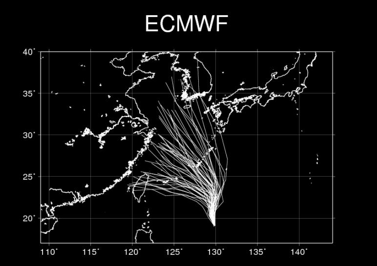
42 Track Prediction for Typhoon SOULIK (2013) Blue portion of the tracks is the Day 1 forecast and the green, orange, and red portions are the Day 2, Day 3, and Day 4 forecasts.
43
44
45 Ensemble Size = 207
46 Black line is the observed track. The number on the black line indicates day(s) from the initial date.
")
47 Track Prediction for Typhoon FITOW (2013)

48 Ensemble Size = 207

49 What is the benefit of using MCGE? Typhoon SOULIK Init.: UTC Typhoon FITOW Init.: UTC MCGE products provide forecasters with additional information on the forecast uncertainty and increase the level of confidence in the forecast.
50 8. Challenges and recommendations


51 Consensus Forecasts Steadiness vs Accuracy Official Forecasts Optimizing the use of numerical track forecasts to minimize the track variability without sacrificing accuracy or timeliness still remains to be developed and studied.


52 Relatively poor performance in forecasting TC track in its weak stage NHC official track forecast error binned by initial intensity for the Atlantic basin. The track errors averaged over the past 5 years are largest for the weakest initial intensity TCs. Model improvements are still required with an emphasis to increase numerical track forecast skill for the weak or initial stages of TCs.
 paper, research on the physics of general TC motion has been almost non-existent, which suggests that most scientists are quite content with the current theories of TC motion.")

53 Observed track Forecast bust including ensembles According to Chan (2010), since Chan et al. (2002) paper, research on the physics of general TC motion has been almost non-existent, which suggests that most scientists are quite content with the current theories of TC motion. In reality, however, significant prediction errors still exist and there are prediction cases where the position error can exceed 1000 km over 3 days. Although the theories of TC motion might have reached a satisfactory level, our knowledge on the causes of prediction errors is still poor. Identifying the causes of large prediction errors and modifying NWP systems accordingly are of great importance to further improve our ability in forecasting TCs. MCGE-9 (BOM, CMA, CMC, CPTEC, ECMWF, JMA, KMA, NCEP, UKMO) Typhoon Megi initiated at 1200 UTC 25 th Oct Typhoon Conson initiated at 1200 UTC 12 th Jul. 2010
54 Petential Recommendations 1/3 Although the position errors of TC track have been on a decreasing trend globally since the time of IWTC-VI in 2006, TC track forecasting remains a high priority. It is recommended that efforts (observations, data assimilation, both global and regional NWP models, and application) should continue to further reduce the errors. Special emphasis should be given to investigation of the causes of large forecast errors and more accurate TC track forecasts in its weak stage and in the landfalling events. Research and development to create optimal deterministic TC tracks from multiple numerical forecasts (i.e. consensus) and to further extend the forecast length (e.g. 7 days) should be encouraged. Systematic verification such as the WGNE intercomparison study in regards to NWP and its TC forecasting should continue to monitor the recent performance as well as the historical progress.
55 Potential Recommendations 2/3 The enhanced use of ensembles in forecasting and research communities should be further encouraged. However more studies are needed in order to develop a more systematic and optimized approach for estimating forecast uncertainty based on ensembles. The development of best practice use of ensemble guidance focusing on calibrated risk estimation across a range of time scales and forecast periods should be supported. The exchange of CXML and TIGGE dataset should be continuously supported for both operational forecasting and research purposes. However, for the CXML, there is some inconsistency in the tracked TCs and the format among the data providers. Also extension of CXML such as including more weather parameters needs to be discussed in accordance with user demand.
56 Potential Recommendations 3/3 From a perspective of disaster risk reduction, research and development and utilization of ensemble-based probabilistic guidance for severe weather events associated with TC motion and its landfalling such as heavy rainfall, strong wind, flood, storm tides, etc. should be encouraged.
57 Potential Discussion Points Verification continues to be important and underpins user confidence and program sponsor support. Exchange of TIGGE data has been critical in achieving this, as has thorough and comprehensive post event best tracking and reporting. There is a need to improve forecast skill with weak systems, landfalling systems and also at longer time periods (> 7 days) and earlier in the system lifecycle (> 5 days prior to formation). There is a also need to understand why forecasts bust, and then identify how to remediate those forecasts. Ensemble forecasts are adding value to forecasts products. Opportunities exist to extract greater value by calibrating risks and by investing how partitioning and clustering can inform forecasters of alternate forecast scenarios. Whilst having calibrated risk estimates of track guidance will inform forecasters, challenges still remain in communicating those risks.
58 들어주셔서감사합니다 (Thank you for your attention) くろじゅそそかむすはむにだ
Tropical cyclone track forecasts using JMA model with ECMWF and JMA initial conditions
 Tropical cyclone track forecasts using JMA model with ECMWF and JMA initial conditions The Fourth THORPEX Asian Science Workshop Kunming, China 2 Nov 2012 (Fri) Munehiko Yamaguchi 1, Tetsuo Nakazawa 1,2
Recent advances in Tropical Cyclone prediction using ensembles
 Recent advances in Tropical Cyclone prediction using ensembles Richard Swinbank, with thanks to Many colleagues in Met Office, GIFS-TIGGE WG & others HC-35 meeting, Curacao, April 2013 Recent advances
Recent Developments of JMA Operational NWP Systems and WGNE Intercomparison of Tropical Cyclone Track Forecast
 Recent Developments of JMA Operational NWP Systems and WGNE Intercomparison of Tropical Cyclone Track Forecast Chiashi Muroi Numerical Prediction Division Japan Meteorological Agency 1 CURRENT STATUS AND
Introduction to TIGGE and GIFS. Richard Swinbank, with thanks to members of GIFS-TIGGE WG & THORPEX IPO
 Introduction to TIGGE and GIFS Richard Swinbank, with thanks to members of GIFS-TIGGE WG & THORPEX IPO GIFS-TIGGE/NCAR/NOAA Workshop on EPS developments, June 2012 TIGGE THORPEX Interactive Grand Global
A review on recent progresses of THORPEX activities in JMA
 4th THORPEX workshop 31 Oct. 2012, Kunming, China A review on recent progresses of THORPEX activities in JMA Masaomi NAKAMURA Typhoon Research Department Meteorological Research Institute / JMA Contents
GIFS-TIGGE working group Report to ICSC. Richard Swinbank Masayuki Kyouda with thanks to other members of GIFS-TIGGE WG and the THORPEX IPO
 GIFS-TIGGE working group Report to ICSC Richard Swinbank Masayuki Kyouda with thanks to other members of GIFS-TIGGE WG and the THORPEX IPO ICSC-11, Geneva, July 2013 GIFS-TIGGE report Working group membership
Seventh International Workshop on Tropical Cyclones (IWTC VII) Special Focus Sessions 1a: Targeted observations for TC track forecasting
 Special Focus Sessions 1a: Targeted observations for TC track forecasting") Seventh International Workshop on Tropical Cyclones (IWTC VII) Special Focus Sessions 1a: Targeted observations for TC track forecasting Chun Chieh Wu 1 and Sharanya J. Majumdar 2 1 Department of Atmospheric
Seventh International Workshop on Tropical Cyclones (IWTC VII) Special Focus Sessions 1a: Targeted observations for TC track forecasting Chun Chieh Wu 1 and Sharanya J. Majumdar 2 1 Department of Atmospheric
Tropical Storm List
 Tropical Storm Email List http://tstorms.org/ tropical-storms@tstorms.org Tropical-Storms is a mailing list only for those who are professionally active in either the research or forecasting of tropical
- Introduction - Technical Presentation 49 th Session of the Typhoon Committee. Yokohama, Japan 21 February Munehiko Yamaguchi
 - Introduction - The Latest Model Simulation and Observational Studies related to Tropical Cyclone in Japan Technical Presentation 49 th Session of the Typhoon Committee Yokohama, Japan 21 February 2017
Fred Branski President CBS
 WMO Typhoon Haiyan, Prediction & Response Can we do better? Fred Branski, President, WMO Commission for Basic Systems Fred Branski President CBS AMS Washington Forum April 3, 2014 Prediction TIGGE makes
Activities of Numerical Weather Prediction for Typhoon forecast at Japan Meteorological Agency
 Activities of Numerical Weather Prediction for Typhoon forecast at Japan Meteorological Agency Masayuki Nakagawa Numerical Prediction Division Japan Meteorological Agency ESCAP/WMO Typhoon Committee Forty-ninth
WGNE intercomparison of Tropical Cyclone Track forecast, 2007
 WGNE intercomparison of Tropical Cyclone Track forecast, 2007 Chiashi Muroi Numerical Prediction Division Prepared by Hirokatsu Onoda and Takuya Komori (NPD/JMA) History of Project 1991 : It began with
International Best Track Archive for Climate Stewardship
 World Meteorological Organization International Best Track Archive for Climate Stewardship Third Workshop (IBTrACS-III) Report and Recommendations Prepared by Kenneth Knapp (Chair) HONOLULU, HAWAII, USA
T-PARC and TCS08 (Submitted by Pat Harr, Russell Elsberry and Tetsuo Nakazawa)
") WORLD METEOROLOGICAL ORGANIZATION COMMISSION FOR ATMOSPHERIC SCIENCES INTERNATIONAL CORE STEERING COMMITTEE FOR THORPEX Eighth Session DWD, Offenbach (2 4 November 2009) CAS/ICSC-8/DOC4.1 (3 X.2009) Item:
WORLD METEOROLOGICAL ORGANIZATION COMMISSION FOR ATMOSPHERIC SCIENCES INTERNATIONAL CORE STEERING COMMITTEE FOR THORPEX Eighth Session DWD, Offenbach (2 4 November 2009) CAS/ICSC-8/DOC4.1 (3 X.2009) Item:
SIXTH INTERNATIONAL WORKSHOP on TROPICAL CYCLONES. Working Group: Phillipe Caroff, Jeff Callaghan, James Franklin, Mark DeMaria
 WMO/CAS/WWW Topic 0.1: Track forecasts SIXTH INTERNATIONAL WORKSHOP on TROPICAL CYCLONES Rapporteur: E-mail: Lixion A. Avila NOAA/National Hurricane Center 11691 SW 17th Street Miami, FL 33165-2149, USA
North Western Pacific Tropical Cyclone (Track) Ensemble Forecast Research Project (NW Pacific TC Project)
 Ensemble Forecast Research Project (NW Pacific TC Project)") TIGGE Real-Time Tropical Cyclone Data for Regional Applications North Western Pacific Tropical Cyclone (Track) Ensemble Forecast Research Project (NW Pacific TC Project) a WWRP Research Development Project
TIGGE Real-Time Tropical Cyclone Data for Regional Applications North Western Pacific Tropical Cyclone (Track) Ensemble Forecast Research Project (NW Pacific TC Project) a WWRP Research Development Project
Topic 2: Cyclogenesis, Intensity and Intensity Change
 EIGHTH INTERNATIONAL WORKSHOP ON TROPICAL CYCLONES Topic 2: Cyclogenesis, Intensity and Intensity Change Topic chairs: Elizabeth A. Ritchie (UA) and Chun-Chieh Wu (NTU) Rapporteurs: Anantha Aiyyar (NCSU),
Current JMA ensemble-based tools for tropical cyclone forecasters
 Current JMA ensemble-based tools for tropical cyclone forecasters Hitoshi Yonehara(yonehara@met.kishou.go.jp) Yoichiro Ota JMA / Numerical Prediction Division Contents Introduction of JMA GSM and EPS NWP
T PARC: Impact of dropsonde (and other) aircraft data
 aircraft data") T PARC: Impact of dropsonde (and other) aircraft data Sharanya J. Majumdar (RSMAS/U. Miami) Martin, Florian Harnisch, Chun Chieh Wu, Tetsuo Nakazawa, Sim Aberson, Hyun Mee Kim, Munehiko Yamaguchi Session
T PARC: Impact of dropsonde (and other) aircraft data Sharanya J. Majumdar (RSMAS/U. Miami) Martin, Florian Harnisch, Chun Chieh Wu, Tetsuo Nakazawa, Sim Aberson, Hyun Mee Kim, Munehiko Yamaguchi Session
Asian THORPEX Implementation Plan
 Asian THORPEX Implementation Plan 1. Introduction This document is to describe the Implementation Plan of the Asian THORPEX, that the Asian THORPEX Regional Committee (ARC) approves. THORPEX was established
Total Energy Singular Vector Guidance Developed at JMA for T-PARC
 Total Energy Singular Vector Guidance Developed at JMA for T-PARC Takuya Komori Numerical Prediction Division, Japan Meteorological Agency Ryota Sakai River Office, Osaka Prefectural Government Hitoshi
JTWC use of ensemble products. Matthew Kucas Joint Typhoon Warning Center Pearl Harbor, HI
 Matthew Kucas Joint Typhoon Warning Center Pearl Harbor, HI Overview Tropical cyclone track forecasting Deterministic model consensus and single-model ensembles as track forecasting aids Conveying uncertainty
Upgrade of JMA s Typhoon Ensemble Prediction System
 Upgrade of JMA s Typhoon Ensemble Prediction System Masayuki Kyouda Numerical Prediction Division, Japan Meteorological Agency and Masakazu Higaki Office of Marine Prediction, Japan Meteorological Agency
COORDINATION WITH OTHER ACTIVITIES OF THE WMO TROPICAL CYCLONE PROGRAMME. (Submitted by the WMO Secretariat) Summary and Purpose of Document
 Summary and Purpose of Document") ESCAP/WMO TYPHOON COMMITTEE FORTY-NINTH SESSION 21-24 FEBRUARY 2017 YOKOHAMA, JAPAN FOR PARTICIPANTS ONLY WRD/TC.49/16 13 February 2017 ENGLISH ONLY COORDINATION WITH OTHER ACTIVITIES OF THE WMO TROPICAL
ESCAP/WMO TYPHOON COMMITTEE FORTY-NINTH SESSION 21-24 FEBRUARY 2017 YOKOHAMA, JAPAN FOR PARTICIPANTS ONLY WRD/TC.49/16 13 February 2017 ENGLISH ONLY COORDINATION WITH OTHER ACTIVITIES OF THE WMO TROPICAL
Medium-range Ensemble Forecasts at the Met Office
 Medium-range Ensemble Forecasts at the Met Office Christine Johnson, Richard Swinbank, Helen Titley and Simon Thompson ECMWF workshop on Ensembles Crown copyright 2007 Page 1 Medium-range ensembles at
Topic 5.2: Seasonal Forecasts
 Topic 5.2: Seasonal Forecasts Contributions from: Maritza Ballester, Eric Blake, Suzanna Camargo, Joanne Camp, Johnny Chan, Phil Klotzbach, Yuriy Kuleshov, Mark Saunders, O. P. Singh, Gabriel Vecchi and
Recent Developments of JMA Operational NWP Systems and WGNE Intercomparison of Tropical Cyclone Track Forecast
 Recent Developments of JMA Operational NWP Systems and WGNE Intercomparison of Tropical Cyclone Track Forecast Masayuki Nakagawa and colleagues at JMA Numerical Prediction Division Japan Meteorological
PRMS WHITE PAPER 2014 NORTH ATLANTIC HURRICANE SEASON OUTLOOK. June RMS Event Response
 PRMS WHITE PAPER 2014 NORTH ATLANTIC HURRICANE SEASON OUTLOOK June 2014 - RMS Event Response 2014 SEASON OUTLOOK The 2013 North Atlantic hurricane season saw the fewest hurricanes in the Atlantic Basin
Probabilistic Evaluation of Prediction and Dynamics of Super Typhoon MEGI (2010)
") Probabilistic Evaluation of Prediction and Dynamics of Super Typhoon MEGI (2010) 6 November 2012 Chuanhai Qian 1, Fuqing Zhang 2, Yihong Duan 1 1 China Meteorological Administration 2 Pennsylvania State
Probabilistic Evaluation of Prediction and Dynamics of Super Typhoon MEGI (2010) 6 November 2012 Chuanhai Qian 1, Fuqing Zhang 2, Yihong Duan 1 1 China Meteorological Administration 2 Pennsylvania State
7B.1 An Overview of the International Best Track Archive for Climate Stewardship (IBTrACS) Michael C. Kruk* STG Inc., Asheville, North Carolina
 Michael C. Kruk* STG Inc., Asheville, North Carolina") 7B.1 An Overview of the International Best Track Archive for Climate Stewardship (IBTrACS) Michael C. Kruk* STG Inc., Asheville, North Carolina Kenneth R. Knapp, David H. Levinson, Howard J. Diamond NOAA
7B.1 An Overview of the International Best Track Archive for Climate Stewardship (IBTrACS) Michael C. Kruk* STG Inc., Asheville, North Carolina Kenneth R. Knapp, David H. Levinson, Howard J. Diamond NOAA
2013 ATLANTIC HURRICANE SEASON OUTLOOK. June RMS Cat Response
 2013 ATLANTIC HURRICANE SEASON OUTLOOK June 2013 - RMS Cat Response Season Outlook At the start of the 2013 Atlantic hurricane season, which officially runs from June 1 to November 30, seasonal forecasts
South Asian Climate Outlook Forum (SASCOF-6)
") Sixth Session of South Asian Climate Outlook Forum (SASCOF-6) Dhaka, Bangladesh, 19-22 April 2015 Consensus Statement Summary Below normal rainfall is most likely during the 2015 southwest monsoon season
Sixth Session of South Asian Climate Outlook Forum (SASCOF-6) Dhaka, Bangladesh, 19-22 April 2015 Consensus Statement Summary Below normal rainfall is most likely during the 2015 southwest monsoon season
The benefits and developments in ensemble wind forecasting
 The benefits and developments in ensemble wind forecasting Erik Andersson Slide 1 ECMWF European Centre for Medium-Range Weather Forecasts Slide 1 ECMWF s global forecasting system High resolution forecast
Structure & Intensity Change: Future Directions IWTC VI, Topic 1
 Structure & Intensity Change: Future Directions IWTC VI, Topic 1 Chair: Rob Rogers Rapporteurs Environmental Impacts (J. Evans) Inner Core Impacts (E. Ritchie) Oceanic Impacts (N. Shay) Observational Capabilities
Recent activities related to EPS (operational aspects)
") Recent activities related to EPS (operational aspects) Junichi Ishida and Carolyn Reynolds With contributions from WGE members 31th WGE Pretoria, South Africa, 26 29 April 2016 GLOBAL 2 Operational global
Recent activities related to EPS (operational aspects) Junichi Ishida and Carolyn Reynolds With contributions from WGE members 31th WGE Pretoria, South Africa, 26 29 April 2016 GLOBAL 2 Operational global
NW Pacific Tropical Cyclone Ensemble Forecast Project
 NW Pacific Tropical Cyclone Ensemble Forecast Project a Joint Project of and TCP in WMO For ESAP/WMO Typhoon Committee Members and Forecasters/Researchers over the Globe Tetsuo NAKAZAWA WMO/ including
NHC Ensemble/Probabilistic Guidance Products
 NHC Ensemble/Probabilistic Guidance Products Michael Brennan NOAA/NWS/NCEP/NHC Mark DeMaria NESDIS/STAR HFIP Ensemble Product Development Workshop 21 April 2010 Boulder, CO 1 Current Ensemble/Probability
Comparison of Typhoon Track Forecast using Dynamical Initialization Schemeinstalled
 IWTC-LP 9 Dec 2014, Jeju, Korea Comparison of Typhoon Track Forecast using Dynamical Initialization Schemeinstalled WRF Hyeonjin Shin, WooJeong Lee, KiRyong Kang, 1) Dong-Hyun Cha and Won-Tae Yun National
GFDL Hurricane Model Ensemble Performance During the 2012 Hurricane Season
 GFDL Hurricane Model Ensemble Performance During the 2012 Hurricane Season Tim Marchok (NOAA / GFDL) Matt Morin (DRC HPTG / GFDL) Morris Bender (NOAA / GFDL) HFIP Team Telecon 12 December 2012 Acknowledgments:
Current Issues and Challenges in Ensemble Forecasting
 Current Issues and Challenges in Ensemble Forecasting Junichi Ishida (JMA) and Carolyn Reynolds (NRL) With contributions from WGNE members 31 th WGNE Pretoria, South Africa, 26 29 April 2016 Recent trends
Sub-seasonal predictions at ECMWF and links with international programmes
 Sub-seasonal predictions at ECMWF and links with international programmes Frederic Vitart and Franco Molteni ECMWF, Reading, U.K. 1 Outline 30 years ago: the start of ensemble, extended-range predictions
Ensemble Prediction Systems
 Ensemble Prediction Systems Eric Blake National Hurricane Center 7 March 2017 Acknowledgements to Michael Brennan 1 Question 1 What are some current advantages of using single-model ensembles? A. Estimates
Probabilistic Weather Forecasting and the EPS at ECMWF
 Probabilistic Weather Forecasting and the EPS at ECMWF Renate Hagedorn European Centre for Medium-Range Weather Forecasts 30 January 2009: Ensemble Prediction at ECMWF 1/ 30 Questions What is an Ensemble
Sub-seasonal predictions at ECMWF and links with international programmes
 Sub-seasonal predictions at ECMWF and links with international programmes Frederic Vitart and Franco Molteni ECMWF, Reading, U.K. Using ECMWF forecasts, 4-6 June 2014 1 Outline Recent progress and plans
IBTrACS: International Best Track Archive for Climate Stewardship. Put your title here too
 IBTrACS: International Best Track Archive for Climate Stewardship Put your title here too 1 The IBTrACS Players Ken Knapp, Paula Hennon, Michael Kruk, Howard Diamond, Ethan Gibney, Carl Schreck NOAA s
Expansion of NCEP Operational Hurricane Weather Research and Forecast (HWRF) Model Forecast Guidance to all Global Tropical Cyclones
 Model Forecast Guidance to all Global Tropical Cyclones") Expansion of NCEP Operational Hurricane Weather Research and Forecast (HWRF) Model Forecast Guidance to all Global Tropical Cyclones Dr. Vijay Tallapragada, Hurricane Team Leader & HFIP Development Manager,
Expansion of NCEP Operational Hurricane Weather Research and Forecast (HWRF) Model Forecast Guidance to all Global Tropical Cyclones Dr. Vijay Tallapragada, Hurricane Team Leader & HFIP Development Manager,
South Asian Climate Outlook Forum (SASCOF-12)
") Twelfth Session of South Asian Climate Outlook Forum (SASCOF-12) Pune, India, 19-20 April 2018 Consensus Statement Summary Normal rainfall is most likely during the 2018 southwest monsoon season (June
Twelfth Session of South Asian Climate Outlook Forum (SASCOF-12) Pune, India, 19-20 April 2018 Consensus Statement Summary Normal rainfall is most likely during the 2018 southwest monsoon season (June
Tropical Cyclone Track Forecasts Using an Ensemble of Dynamical Models
 1187 Tropical Cyclone Track Forecasts Using an Ensemble of Dynamical Models JAMES S. GOERSS Naval Research Laboratory, Monterey, California (Manuscript received 26 August 1998, in final form 14 May 1999)
2017 Year in review: JTWC TC Activity, Forecast Challenges, and Developmental Priorities
 2017 Year in review: JTWC TC Activity, Forecast Challenges, and Developmental Priorities Mean Annual TC Activity????????? Hurricane Forecast Improvement Program Annual Review 8-9 NOV 2017 Brian Strahl,
Topic 3.2: Tropical Cyclone Variability on Seasonal Time Scales (Observations and Forecasting)
") Topic 3.2: Tropical Cyclone Variability on Seasonal Time Scales (Observations and Forecasting) Phil Klotzbach 7 th International Workshop on Tropical Cyclones November 18, 2010 Working Group: Maritza Ballester
Topic 3.2: Tropical Cyclone Variability on Seasonal Time Scales (Observations and Forecasting) Phil Klotzbach 7 th International Workshop on Tropical Cyclones November 18, 2010 Working Group: Maritza Ballester
Application of NWP products and meteorological information processing system in Hong Kong
 Application of NWP products and meteorological information processing system in Hong Kong Y.S. Li Scientific Officer Hong Kong Observatory (ysli@hko.gov.hk) 7 million people Hong Kong ~1,100 km sq. Regional
Tropical Cyclone Data Impact Studies: Influence of Model Bias and Synthetic Observations
 Tropical Cyclone Data Impact Studies: Influence of Model Bias and Synthetic Observations C. Reynolds, R. Langland and P. Pauley, Naval Research Laboratory, Marine Meteorology Division, Monterey, CA C.
1. Introduction. 2. Verification of the 2010 forecasts. Research Brief 2011/ February 2011
 Research Brief 2011/01 Verification of Forecasts of Tropical Cyclone Activity over the Western North Pacific and Number of Tropical Cyclones Making Landfall in South China and the Korea and Japan region
Variations of Typhoon Activity in Asia - Global Warming and/or Natural Cycles?
 Variations of Typhoon Activity in Asia - Global Warming and/or Natural Cycles? Johnny Chan Guy Carpenter Asia-Pacific Climate Impact Centre City University of Hong Kong Tropical Cyclones Affecting the
COLORADO STATE UNIVERSITY FORECAST OF ATLANTIC HURRICANE ACTIVITY FROM AUGUST 17 AUGUST 30, 2012
 COLORADO STATE UNIVERSITY FORECAST OF ATLANTIC HURRICANE ACTIVITY FROM AUGUST 17 AUGUST 30, 2012 We expect that the next two weeks will be characterized by above-average amounts (greater than 130 percent)
Science Objectives contained in three categories
 Summer THORPEX-Pacific Asian Regional Campaign/Tropical Cyclone Structure-08 Experiments and Collaborative Efforts Science Objectives contained in three categories Increase predictability of high-impact
OBJECTIVE CALIBRATED WIND SPEED AND CROSSWIND PROBABILISTIC FORECASTS FOR THE HONG KONG INTERNATIONAL AIRPORT
 P 333 OBJECTIVE CALIBRATED WIND SPEED AND CROSSWIND PROBABILISTIC FORECASTS FOR THE HONG KONG INTERNATIONAL AIRPORT P. Cheung, C. C. Lam* Hong Kong Observatory, Hong Kong, China 1. INTRODUCTION Wind is
Web-Based Decision Support Tool
 Web-Based Decision Support Tool PAULA MCCASLIN AND KIRK HOLUB NOAA / GSD 5/11/11 NOAA Earth Systems Research Laboratory Personal Weather Advisor (concept idea) Decision Support in Weather-Sensitive Situations
South Asian Climate Outlook Forum (SASCOF-8)
") Eighth Session of South Asian Climate Outlook Forum (SASCOF-8) Colombo, Sri Lanka, 25-26 April 2016 Consensus Statement Summary Above-normal rainfall is most likely during the 2016 southwest monsoon season
Eighth Session of South Asian Climate Outlook Forum (SASCOF-8) Colombo, Sri Lanka, 25-26 April 2016 Consensus Statement Summary Above-normal rainfall is most likely during the 2016 southwest monsoon season
TIGGE at ECMWF. David Richardson, Head, Meteorological Operations Section Slide 1. Slide 1
 TIGGE at ECMWF David Richardson, Head, Meteorological Operations Section david.richardson@ecmwf.int Slide 1 Slide 1 ECMWF TIGGE archive The TIGGE database now contains five years of global EPS data Holds
Verification challenges in developing TC response procedures based on ensemble guidance
 Verification challenges in developing TC response procedures based on ensemble guidance Grant Elliott Senior Metocean Meteorologist ECMWF UEF 2016 workshop Disclaimer and important notice This presentation
AN OBSERVING SYSTEM EXPERIMENT OF MTSAT RAPID SCAN AMV USING JMA MESO-SCALE OPERATIONAL NWP SYSTEM
 AN OBSERVING SYSTEM EXPERIMENT OF MTSAT RAPID SCAN AMV USING JMA MESO-SCALE OPERATIONAL NWP SYSTEM Koji Yamashita Japan Meteorological Agency / Numerical Prediction Division 1-3-4, Otemachi, Chiyoda-ku,
Extended-range/Monthly Predictions. WGSIP, Trieste
 Extended-range/Monthly Predictions WGSIP, Trieste 1 Sub-seasonal to Seasonal Prediction: Met Office, Exeter (1 to 3 December 2010) Purpose Review of the current capabilities in sub seasonal to seasonal
THORPEX Data Assimilation and Observing Strategies Working Group: scientific objectives
 THORPEX Data Assimilation and Observing Strategies Working Group: scientific objectives Pierre Gauthier Co-chair of the DAOS-WG Atmospheric Science and Technology Branch Environment Canada Data assimilation
Summary. peninsula. likely over. parts of. Asia has. have now. season. There is. season, s that the. declining. El Niño. affect the. monsoon.
 Eighth Session of South Asian Climate Outlook Forum (SASCOF-8) Colombo, Sri Lanka, 25-26 April 2016 Consensus Statement Summary Above-normal rainfalll is likely during the 2016 southwest monsoon season
Overview of the Tropical Cyclone Guidance Project
 Overview of the Tropical Cyclone Guidance Project Dr. Jonathan L. Vigh With thanks to Mahsa Mirzargar (Univ. of Miami) Shanghai Typhoon Institute 09 July 2018 NCAR is sponsored by the National Science
(April 7, 2010, Wednesday) Tropical Storms & Hurricanes Part 2
 Tropical Storms & Hurricanes Part 2") Lecture #17 (April 7, 2010, Wednesday) Tropical Storms & Hurricanes Part 2 Hurricane Katrina August 2005 All tropical cyclone tracks (1945-2006). Hurricane Formation While moving westward, tropical disturbances
Lecture #17 (April 7, 2010, Wednesday) Tropical Storms & Hurricanes Part 2 Hurricane Katrina August 2005 All tropical cyclone tracks (1945-2006). Hurricane Formation While moving westward, tropical disturbances
On the Ability of Global Ensemble Prediction Systems to Predict Tropical Cyclone Track Probabilities
 APRIL 2010 M A J U M D A R A N D F I N O C C H I O 659 On the Ability of Global Ensemble Prediction Systems to Predict Tropical Cyclone Track Probabilities SHARANYA J. MAJUMDAR AND PETER M. FINOCCHIO University
COLORADO STATE UNIVERSITY FORECAST OF ATLANTIC HURRICANE ACTIVITY FROM AUGUST 31 SEPTEMBER 13, 2012
 COLORADO STATE UNIVERSITY FORECAST OF ATLANTIC HURRICANE ACTIVITY FROM AUGUST 31 SEPTEMBER 13, 2012 We expect that the next two weeks will be characterized by average amounts (70-130 percent) of activity
Challenges and Advances related to TC Rainfall Forecast. WOO Wang-chun Hong Kong Observatory IWTCLP-III, Jeju, Korea 10 Dec 2014
 Challenges and Advances related to TC Rainfall Forecast WOO Wang-chun Hong Kong Observatory IWTCLP-III, Jeju, Korea 10 Dec 2014 Working Group Composition Member Wallace HOGSETT Affiliations Weather Analytics,
COLORADO STATE UNIVERSITY FORECAST OF ATLANTIC HURRICANE ACTIVITY FROM AUGUST 16 AUGUST 29, 2013
 COLORADO STATE UNIVERSITY FORECAST OF ATLANTIC HURRICANE ACTIVITY FROM AUGUST 16 AUGUST 29, 2013 We expect that the next two weeks will be characterized by above-average amounts (greater than 130 percent)
ACCESS AGREPS Ensemble Prediction System
 ACCESS AGREPS Ensemble Prediction System Michael Naughton CAWCR Earth System Modelling Model Data Fusion Workshop 10-12 May 2010 Motivation for Ensemble Prediction NWP forecasts greatly improved but are
Precipitation verification. Thanks to CMC, CPTEC, DWD, ECMWF, JMA, MF, NCEP, NRL, RHMC, UKMO
 Precipitation verification Thanks to CMC, CPTEC, DWD, ECMWF, JMA, MF, NCEP, NRL, RHMC, UKMO Outline 1) Status of WGNE QPF intercomparisons 2) Overview of the use of recommended methods for the verification
Tropical Cyclone Mesoscale Data Assimilation
 Tropical Cyclone Mesoscale Data Assimilation Sharan Majumdar (RSMAS / U. Miami) Chris Velden (CIMSS / U. Wisconsin) Acknowledgments: Ryan Torn (SUNY at Albany), Altug Aksoy and Tomislava Vukicevic (NOAA/AOML/HRD)
Fernando Prates. Evaluation Section. Slide 1
 Fernando Prates Evaluation Section Slide 1 Objectives Ø Have a better understanding of the Tropical Cyclone Products generated at ECMWF Ø Learn the recent developments in the forecast system and its impact
The Progresses of THORPEX Activities in China
 The 4 th THORPEX Asia Science Workshop The Progresses of THORPEX Activities in China XU Xiaofeng Chairman of THORPEX China committee 31 October 2012, Kunming, China 1 OUTLINE Research focuses of THORPEX
Exploiting ensemble members: forecaster-driven EPS applications at the met office
 Exploiting ensemble members: forecaster-driven EPS applications at the met office Introduction Ensemble Prediction Systems (EPSs) have assumed a central role in the forecast process in recent years. The
The Use of GPS Radio Occultation Data for Tropical Cyclone Prediction. Bill Kuo and Hui Liu UCAR
 The Use of GPS Radio Occultation Data for Tropical Cyclone Prediction Bill Kuo and Hui Liu UCAR Current capability of the National Hurricane Center Good track forecast improvements. Errors cut in half
Verification of Tropical Storm Track Prediction in Southeast Asia Using GFS Model
 1 Verification of Tropical Storm Track Prediction in Southeast Asia Using GFS Model Honors Thesis Presented to the College of Agriculture and Life Sciences Department of Earth and Atmospheric Sciences
10 Tropical Cyclone Training
 Chapter Ten Charles 'Chip' Guard USNR (Retired) US National Oceanic and Atmospheric Administration Science Applications International Corporation National Weather Service Forecast Office Guam 10 Tropical
THORPEX A World Weather Research Programme
 THORPEX A World Weather Research Programme IMPLEMENTATION PLAN David Rogers, Chair WMO Expert Group for THORPEX International Research Implementation Plan THORPEX Management Structure agreed at ICSC-4
Challenging Aspects of Severe Tropical Cyclone George s s Track Forecasts
 Challenging Aspects of Severe Tropical Cyclone George s s Track Forecasts Jim DAVIDSON Former Affilliation Severe Tropical Cyclone George bears down on the Western Australian Coast in early March 2007
Variations of Typhoon Activity in Asia - Global Warming and/or Natural Cycles?
 Variations of Typhoon Activity in Asia - Global Warming and/or Natural Cycles? Johnny Chan Guy Carpenter Asia-Pacific Climate Impact Centre City University of Hong Kong Outline The common perception and
11A.1 PREDICTION OF TROPICAL CYCLONE TRACK FORECAST ERROR FOR HURRICANES KATRINA, RITA, AND WILMA
 11A.1 PREDICTION OF TROPICAL CYCLONE TRACK FORECAST ERROR FOR HURRICANES KATRINA, RITA, AND WILMA James S. Goerss* Naval Research Laboratory, Monterey, California 1. INTRODUCTION Consensus tropical cyclone
EL NIÑO/LA NIÑA UPDATE
 World Meteorological Organization EL NIÑO/LA NIÑA UPDATE Current Situation and Outlook A mature and strong El Niño is now present in the tropical Pacific Ocean. The majority of international climate outlook
The impact of assimilation of microwave radiance in HWRF on the forecast over the western Pacific Ocean
 The impact of assimilation of microwave radiance in HWRF on the forecast over the western Pacific Ocean Chun-Chieh Chao, 1 Chien-Ben Chou 2 and Huei-Ping Huang 3 1Meteorological Informatics Business Division,
2016 and 2017 Reviews of Probability-circle Radii in Tropical Cyclone Track Forecasts
 216 and 217 Reviews of Probability-circle Radii in Tropical Cyclone Track Forecasts Junya Fukuda Tokyo Typhoon Center, Forecast Division, Forecast Department, Japan Meteorological Agency 1. Introduction
Tropical Cyclone Formation/Structure/Motion Studies
 Tropical Cyclone Formation/Structure/Motion Studies Patrick A. Harr Department of Meteorology Naval Postgraduate School Monterey, CA 93943-5114 phone: (831) 656-3787 fax: (831) 656-3061 email: paharr@nps.edu
Uncertainty in Operational Atmospheric Analyses. Rolf Langland Naval Research Laboratory Monterey, CA
 Uncertainty in Operational Atmospheric Analyses 1 Rolf Langland Naval Research Laboratory Monterey, CA Objectives 2 1. Quantify the uncertainty (differences) in current operational analyses of the atmosphere
SIXTH INTERNATIONAL WORKSHOP on TROPICAL CYCLONES
 WMO/CAS/WWW SIXTH INTERNATIONAL WORKSHOP on TROPICAL CYCLONES Topic 4a : Updated Statement on the Possible Effects of Climate Change on Tropical Cyclone Activity/Intensity Rapporteur: E-mail: John McBride
IMPACT STUDIES OF AMVS AND SCATTEROMETER WINDS IN JMA GLOBAL OPERATIONAL NWP SYSTEM
 IMPACT STUDIES OF AMVS AND SCATTEROMETER WINDS IN JMA GLOBAL OPERATIONAL NWP SYSTEM Koji Yamashita Japan Meteorological Agency / Numerical Prediction Division 1-3-4, Otemachi, Chiyoda-ku, Tokyo 100-8122,
MJO prediction Intercomparison using the S2S Database Frédéric Vitart (ECMWF)
") MJO prediction Intercomparison using the S2S Database Frédéric Vitart (ECMWF) Slide 1 WGNE Meeting 29 April 2016 1 INDEX The S2S project and S2S Database MJO prediction in S2S models MJO teleconnections
MJO prediction Intercomparison using the S2S Database Frédéric Vitart (ECMWF) Slide 1 WGNE Meeting 29 April 2016 1 INDEX The S2S project and S2S Database MJO prediction in S2S models MJO teleconnections
Targeted Observations of Tropical Cyclones Based on the
 Targeted Observations of Tropical Cyclones Based on the Adjoint-Derived Sensitivity Steering Vector Chun-Chieh Wu, Po-Hsiung Lin, Jan-Huey Chen, and Kun-Hsuan Chou Department of Atmospheric Sciences, National
Briefing on the WMO Support to Viet Nam to cope with Typhoon Haiyan
 WMO Briefing on the WMO Support to Viet Nam to cope with Typhoon Haiyan A Case of WMO Emergency Response Typhoon Haiyan trajectory Background Typhoon Haiyan remained strong after devastating the Philippines
DA/Initialization/Ensemble Development Team Milestones and Priorities
 DA/Initialization/Ensemble Development Team Milestones and Priorities Presented by Xuguang Wang HFIP annual review meeting Jan. 11-12, 2017, Miami, FL Fully cycled, self-consistent, dual-resolution, GSI
Impact of GPS RO Data on the Prediction of Tropical Cyclones
 Impact of GPS RO Data on the Prediction of Tropical Cyclones Ying-Hwa Kuo, Hui Liu, UCAR Ching-Yuang Huang, Shu-Ya Chen, NCU Ling-Feng Hsiao, Ming-En Shieh, Yu-Chun Chen, TTFRI Outline Tropical cyclone
Impact of Stochastic Convection on Ensemble Forecasts of Tropical Cyclone Development
 620 M O N T H L Y W E A T H E R R E V I E W VOLUME 139 Impact of Stochastic Convection on Ensemble Forecasts of Tropical Cyclone Development ANDREW SNYDER AND ZHAOXIA PU Department of Atmospheric Sciences,
The 2009 Hurricane Season Overview
 The 2009 Hurricane Season Overview Jae-Kyung Schemm Gerry Bell Climate Prediction Center NOAA/ NWS/ NCEP 1 Overview outline 1. Current status for the Atlantic, Eastern Pacific and Western Pacific basins
Observing System Experiments using a singular vector method for 2004 DOTSTAR cases
 Observing System Experiments using a singular vector method for 2004 DOTSTAR cases Korea-Japan-China Second Joint Conference on Meteorology 11 OCT. 2006 Munehiko YAMAGUCHI 1 Takeshi IRIGUCHI 1 Tetsuo NAKAZAWA
Development Project High Resolution Numerical Prediction of Landfalling Typhoon Rainfall (tentative title)
") A Proposal for the WMO/WWRP Research and Development Project High Resolution Numerical Prediction of Landfalling Typhoon Rainfall (tentative title) Yihong Duan WGTMR Proposed in the side meeting of the
A Proposal for the WMO/WWRP Research and Development Project High Resolution Numerical Prediction of Landfalling Typhoon Rainfall (tentative title) Yihong Duan WGTMR Proposed in the side meeting of the