WGNE intercomparison of Tropical Cyclone Track forecast, 2007
|
|
|
- Phoebe Bryant
- 5 years ago
- Views:
Transcription
1 WGNE intercomparison of Tropical Cyclone Track forecast, 2007 Chiashi Muroi Numerical Prediction Division Prepared by Hirokatsu Onoda and Takuya Komori (NPD/JMA) History of Project 1991 : It began with three centers: ECMWF, UKMO and JMA, and the verification area was only western North Pacific : CMC joined : Verification of North Atlantic started : DWD joined. Verification of eastern North Pacific started : Verification of Southern Hemisphere, north Indian Ocean and Central Pacific started : NCEP and BoM joined. A website for this intercomparison project was released : Meteo-France and CMA joined : CPTEC and NRL joined : 9 NWP centers participated in a project. BoM CMC DWD ECMWF JMA France NCEP NRL UKMO
 France 2004 used* 0.5x0.5 T538C2.4L70 NCEP 2003 used in rare case 1.0x1.0 T382L64 NRL 2006 used 1.0x1.0 T239L30 UKMO 1991 used 0.")

2 NWP centers Participate Year Bogus data Horizontal Res. of provided data Model Res. as of 2007 BoM x0.75 T L 239L33 CMC x1.0 35kmL58 DWD x kmL40 ECMWF x0.25 T L 799L91 JMA 1991 Specification of Data used in WNP 1.25x1.25 T L 319L40 T L 959L60(Nov.) France 2004 used* 0.5x0.5 T538C2.4L70 NCEP 2003 used in rare case 1.0x1.0 T382L64 NRL 2006 used 1.0x1.0 T239L30 UKMO 1991 used x kmL70 * except for South Pacific and north Indian-Ocean 1 : TC Verification TC tracks on 2007 season Northern-Hemisphere [2007/01/01 to 2007/12/31] Southern-Hemisphere [2006/09/01 to 2007/08/31] Number of TCs, [besttrack data provider] 24 western North-Pacific [RSMC Tokyo] 11 eastern North-Pacific (including Central-Pacific) [RSMC Miami,Honolulu] 15 North Atlantic [RSMC Miami] 4 north Indian-Ocean [RSMC New-Delhi] 10 south Indian-Ocean [RSMC La-Reunion] Not yet
 stage of the targeted TCs is also included in this verification. However, the TCs which stayed at TD level all through their life are excluded. 1.")
 2.")
3 TCs to be verified Method of TC verification using MSLP TCs which intensity reached tropical storm (TS) with the maximum sustained wind of 34 knots or stronger are set as targets for this verification. The tropical depression (TD) stage of the targeted TCs is also included in this verification. However, the TCs which stayed at TD level all through their life are excluded. 1. Tracking Method local pressure minimum; a) First position (FT +0hr) : search from the best track position b) Second position (FT +12hr) : search from the first position c) Third and after (FT +24hr~) : search from estimated position from the latest two positions (all position searched within 500km 5 radius) 2. Verification Method Position Error km The distance between the best-track (analyzed) position and the forecast position. Along Track Cross Track bias AT(along-track)-bias : The bias in the direction of TC movement CT(cross-track)-bias : The bias in the rectangular direction of TC movement Detection Rate % Detection Rate (t) = A(t)/ B(t) A(t) ) : The number of forecast events in which a TC is analyzed at forecast time t on the condition that a NWP model continuously expresses the TC until the forecast time t. B(t) ) : The number of forecast events in which a TC is analyzed at forecast time t.


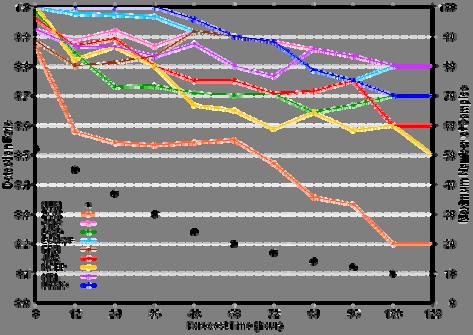
4 (a) Verification of western North-Pacific (WNP) domain Position Error 24 TCs in 2007 (a) WNP domain Detection Rate better DetectionRate PositionError map
 direction and X-axis does that in Cross Track (CT) direction.")
5 JMA (a) WNP domain AT-CT bias map (FT +72) ECMWF UKMO CMC DWD NCEP BoM Meteo France NRL Scattering diagram of TC positions at 72 hour forecast. Red : Before recurvature Green : During recurvature Blue : After recurvature Y-axis represents position errors in Along Track (AT) direction and X-axis does that in Cross Track (CT) direction. Unit: km (a) WNP domain Central Pressure scattering diagram (FT +72) JMA ECMWF UKMO CMC DWD NCEP BoM Meteo France NRL Scattering diagram of central pressure at 72 hour forecast. Y-axis represents central pressure of forecast and X-axis does that of analysis. Unit: hpa


6 Time series of 2-day and 4-day forecast of JMA, ECM, UKM and 3centers ensemble in WNP domain. Position Error 2006 season 2007 season Detection Rate 2006 season 2007 season


7 (b) Verification of North-Atlantic (NAT) domain Position Error 15 TCs in 2007 (b) NAT domain Detection Rate better DetectionRate PositionError map

 domain")


8 (c) Verification of eastern North-Pacific (ENP) domain Position Error 11 TCs in 2007 Including Central-Pacific (c) ENP domain Detection Rate better DetectionRate PositionError map

9 A characteristic according to the domain of Northern Hemisphere.


 SIO")

10 (d) Verification of south Indian-Ocean (SIO) domain Position Error 10 TCs in 2007 (d) SIO domain Detection Rate better DetectionRate PositionError map


11 2 : Verification using WIND data It s important for a model to express TC correctly not only the position but also wind distribution. A method to decide the TC wind structure of model Set the center to tracked TC point (minimum MSLP), average wind vector in each point of every angle θ on the concentric circle with radius R. The wind vector is interpolated from four nearest points of provided wind grid data (10m U, V). We set values to: r=25km, θ=2, R max =1000km We chose 2 cases in these condition : - TC structure is form of concentric circle - There is no influence of the topography - Being the stage which TC develops most Case1: T0705(USAGI) track forecast 12Z 28Jul Z 29Jul Z 30Jul Z 31Jul2007
 0.5625 x 0.")
12 Case1: T0705(USAGI) R50,R30 : 50kt and 30kt wind radius analyzed by RSMC Tokyo leadtime=0 means each model s analysis. leadtime=24 means 1-day forecast. Please be careful to this verification method depending on the horizontal resolution of wind data x 1.25 (same as Pmsl res.) x (Operational) Case1: T0705(USAGI) valid time : 2007/08/01 12Z 0.75 x x x x x x 0.375


13 Case2: T0715(KROSA) track forecast 12Z 01Oct Z 02Oct Z 03Oct Z 04Oct2007 Case2: T0715(KROSA) R50,R30 : 50kt and 30kt wind radius analyzed by RSMC Tokyo leadtime=0 means each model s analysis. leadtime=24 means 1-day forecast x x

14 Case2: T0715(KROSA) valid time : 2007/10/05 12Z 0.75 x x x x x x TC intercomparison website on JMA < Login ID: verif Password: wgne2008 (beyond 30 Nov. 2008) Contact: wgne_tc@naps.kishou.go.jp


15 EXTRA slides The time change of the horizontal scale of the TC. black line: 30kt wind radius analyzed by RSMC Tokyo. (Except for TD stage.) colored line: 20kt wind radius of each Initial date. (Because the forecast of most centers was weak at wind.) JMA T0708(SEPAT) T0709(FITOW) Track (Course) Pmsl (Intensity) Wind-radius (Scale)
 Track (Course)")
 CMC")
")
16 BOM T0708(SEPAT) T0709(FITOW) Track (Course) Pmsl (Intensity) Wind-radius (Scale) CMC T0708(SEPAT) T0709(FITOW) Track (Course) Pmsl (Intensity) Wind-radius (Scale)
 Pmsl (Intensity) Wind-radius")
 Track (Scale)")
17 ECMWF T0708(SEPAT) T0709(FITOW) Track (Course) Pmsl (Intensity) Wind-radius (Scale) Meteo France T0708(SEPAT) T0709(FITOW) Track (Course) Pmsl (Intensity) Wind-radius (Scale)
 Pmsl (Intensity) Wind-radius")
")
18 NRL T0708(SEPAT) T0709(FITOW) Track (Course) Pmsl (Intensity) Wind-radius (Scale) UKMO T0708(SEPAT) T0709(FITOW) Track (Course) Pmsl (Intensity) Wind-radius (Scale)
Recent Developments of JMA Operational NWP Systems and WGNE Intercomparison of Tropical Cyclone Track Forecast
 Recent Developments of JMA Operational NWP Systems and WGNE Intercomparison of Tropical Cyclone Track Forecast Chiashi Muroi Numerical Prediction Division Japan Meteorological Agency 1 CURRENT STATUS AND
Current JMA ensemble-based tools for tropical cyclone forecasters
 Current JMA ensemble-based tools for tropical cyclone forecasters Hitoshi Yonehara(yonehara@met.kishou.go.jp) Yoichiro Ota JMA / Numerical Prediction Division Contents Introduction of JMA GSM and EPS NWP
Activities of Numerical Weather Prediction for Typhoon forecast at Japan Meteorological Agency
 Activities of Numerical Weather Prediction for Typhoon forecast at Japan Meteorological Agency Masayuki Nakagawa Numerical Prediction Division Japan Meteorological Agency ESCAP/WMO Typhoon Committee Forty-ninth
Recent Developments of JMA Operational NWP Systems and WGNE Intercomparison of Tropical Cyclone Track Forecast
 Recent Developments of JMA Operational NWP Systems and WGNE Intercomparison of Tropical Cyclone Track Forecast Masayuki Nakagawa and colleagues at JMA Numerical Prediction Division Japan Meteorological
Precipitation verification. Thanks to CMC, CPTEC, DWD, ECMWF, JMA, MF, NCEP, NRL, RHMC, UKMO
 Precipitation verification Thanks to CMC, CPTEC, DWD, ECMWF, JMA, MF, NCEP, NRL, RHMC, UKMO Outline 1) Status of WGNE QPF intercomparisons 2) Overview of the use of recommended methods for the verification
North Western Pacific Tropical Cyclone (Track) Ensemble Forecast Research Project (NW Pacific TC Project)
 Ensemble Forecast Research Project (NW Pacific TC Project)") TIGGE Real-Time Tropical Cyclone Data for Regional Applications North Western Pacific Tropical Cyclone (Track) Ensemble Forecast Research Project (NW Pacific TC Project) a WWRP Research Development Project
TIGGE Real-Time Tropical Cyclone Data for Regional Applications North Western Pacific Tropical Cyclone (Track) Ensemble Forecast Research Project (NW Pacific TC Project) a WWRP Research Development Project
NW Pacific Tropical Cyclone Ensemble Forecast Project
 NW Pacific Tropical Cyclone Ensemble Forecast Project a Joint Project of and TCP in WMO For ESAP/WMO Typhoon Committee Members and Forecasters/Researchers over the Globe Tetsuo NAKAZAWA WMO/ including
MJO prediction Intercomparison using the S2S Database Frédéric Vitart (ECMWF)
") MJO prediction Intercomparison using the S2S Database Frédéric Vitart (ECMWF) Slide 1 WGNE Meeting 29 April 2016 1 INDEX The S2S project and S2S Database MJO prediction in S2S models MJO teleconnections
MJO prediction Intercomparison using the S2S Database Frédéric Vitart (ECMWF) Slide 1 WGNE Meeting 29 April 2016 1 INDEX The S2S project and S2S Database MJO prediction in S2S models MJO teleconnections
Upgrade of JMA s Typhoon Ensemble Prediction System
 Upgrade of JMA s Typhoon Ensemble Prediction System Masayuki Kyouda Numerical Prediction Division, Japan Meteorological Agency and Masakazu Higaki Office of Marine Prediction, Japan Meteorological Agency
Outline of 4 Lectures
 Outline of 4 Lectures 1. Sept. 17, 2008: TC best track definition and datasets, global distribution of TCs; Review of history of meteorological satellites, introducing different orbits, scanning patterns,
GIFS-TIGGE working group Report to ICSC. Richard Swinbank Masayuki Kyouda with thanks to other members of GIFS-TIGGE WG and the THORPEX IPO
 GIFS-TIGGE working group Report to ICSC Richard Swinbank Masayuki Kyouda with thanks to other members of GIFS-TIGGE WG and the THORPEX IPO ICSC-11, Geneva, July 2013 GIFS-TIGGE report Working group membership
Introduction to TIGGE and GIFS. Richard Swinbank, with thanks to members of GIFS-TIGGE WG & THORPEX IPO
 Introduction to TIGGE and GIFS Richard Swinbank, with thanks to members of GIFS-TIGGE WG & THORPEX IPO GIFS-TIGGE/NCAR/NOAA Workshop on EPS developments, June 2012 TIGGE THORPEX Interactive Grand Global
AN OBSERVING SYSTEM EXPERIMENT OF MTSAT RAPID SCAN AMV USING JMA MESO-SCALE OPERATIONAL NWP SYSTEM
 AN OBSERVING SYSTEM EXPERIMENT OF MTSAT RAPID SCAN AMV USING JMA MESO-SCALE OPERATIONAL NWP SYSTEM Koji Yamashita Japan Meteorological Agency / Numerical Prediction Division 1-3-4, Otemachi, Chiyoda-ku,
Verification at JMA on Ensemble Prediction
 Verification at JMA on Ensemble Prediction - Part Ⅱ : Seasonal prediction - Yukiko Naruse, Hitoshi Sato Climate Prediction Division Japan Meteorological Agency 05/11/08 05/11/08 Training seminar on Forecasting
IMPACT STUDIES OF AMVS AND SCATTEROMETER WINDS IN JMA GLOBAL OPERATIONAL NWP SYSTEM
 IMPACT STUDIES OF AMVS AND SCATTEROMETER WINDS IN JMA GLOBAL OPERATIONAL NWP SYSTEM Koji Yamashita Japan Meteorological Agency / Numerical Prediction Division 1-3-4, Otemachi, Chiyoda-ku, Tokyo 100-8122,
Annual Report on the Activities of the RSMC Tokyo - Typhoon Center 2014
 Annual Report on the Activities of the RSMC Tokyo - Typhoon Center 2014 TY Vongfong 23 UTC, 7 October 2014 Japan Meteorological Agency Annual Report on the Activities of the RSMC Tokyo - Typhoon Center
Annual Report on the Activities of the RSMC Tokyo - Typhoon Center 2012
 Annual Report on the Activities of the RSMC Tokyo - Typhoon Center 2012 TY Sanba 00 UTC, 14 September 2012 Japan Meteorological Agency Annual Report on the Activities of the RSMC Tokyo - Typhoon Center
Reduction of the Radius of Probability Circle. in Typhoon Track Forecast
 Reduction of the Radius of Probability Circle in Typhoon Track Forecast Nobutaka MANNOJI National Typhoon Center, Japan Meteorological Agency Abstract RSMC Tokyo - Typhoon Center of the Japan Meteorological
Development of JMA storm surge model
 2 nd JCOMM Scientific and Technical Symposium on Storm Surges 8-13 November 2015, Key West, Florida, USA Development of JMA storm surge model Hiroshi HASEGAWA (h_hasegawa@met.kishou.go.jp) Office of Marine
Storm surge modeling at RSMC La Réunion. Cliquez pour modifier le style des sous-titres du masque
 Storm surge modeling at RSMC La Réunion Cliquez pour modifier le style du titre Cliquez pour modifier le style des sous-titres du masque 6th session training course of tropical cyclones (28 oct. 5 nov.
Study for utilizing high wind speed data in the JMA s Global NWP system
 Study for utilizing high wind speed data in the JMA s Global NWP system Masami Moriya Numerical Prediction Division, Japan Meteorological Agency (JMA) IOVWST Meeting, Portland, USA, 19-21 May 2015 1 Contents
Recent activities related to EPS (operational aspects)
") Recent activities related to EPS (operational aspects) Junichi Ishida and Carolyn Reynolds With contributions from WGE members 31th WGE Pretoria, South Africa, 26 29 April 2016 GLOBAL 2 Operational global
Recent activities related to EPS (operational aspects) Junichi Ishida and Carolyn Reynolds With contributions from WGE members 31th WGE Pretoria, South Africa, 26 29 April 2016 GLOBAL 2 Operational global
Masahiro Kazumori, Takashi Kadowaki Numerical Prediction Division Japan Meteorological Agency
 Development of an all-sky assimilation of microwave imager and sounder radiances for the Japan Meteorological Agency global numerical weather prediction system Masahiro Kazumori, Takashi Kadowaki Numerical
How far in advance can we forecast cold/heat spells?
 Sub-seasonal time scales: a user-oriented verification approach How far in advance can we forecast cold/heat spells? Laura Ferranti, L. Magnusson, F. Vitart, D. Richardson, M. Rodwell Danube, Feb 2012
2016 and 2017 Reviews of Probability-circle Radii in Tropical Cyclone Track Forecasts
 216 and 217 Reviews of Probability-circle Radii in Tropical Cyclone Track Forecasts Junya Fukuda Tokyo Typhoon Center, Forecast Division, Forecast Department, Japan Meteorological Agency 1. Introduction
T-PARC and TCS08 (Submitted by Pat Harr, Russell Elsberry and Tetsuo Nakazawa)
") WORLD METEOROLOGICAL ORGANIZATION COMMISSION FOR ATMOSPHERIC SCIENCES INTERNATIONAL CORE STEERING COMMITTEE FOR THORPEX Eighth Session DWD, Offenbach (2 4 November 2009) CAS/ICSC-8/DOC4.1 (3 X.2009) Item:
WORLD METEOROLOGICAL ORGANIZATION COMMISSION FOR ATMOSPHERIC SCIENCES INTERNATIONAL CORE STEERING COMMITTEE FOR THORPEX Eighth Session DWD, Offenbach (2 4 November 2009) CAS/ICSC-8/DOC4.1 (3 X.2009) Item:
A Preliminary Climatology of Extratropical Transitions in the Southwest Indian Ocean
 A Preliminary Climatology of Extratropical Transitions in the Southwest Indian Ocean Kyle S. Griffin Department of Atmospheric and Environmental Sciences, University at Albany, State University of New
Tropical Storm List
 Tropical Storm Email List http://tstorms.org/ tropical-storms@tstorms.org Tropical-Storms is a mailing list only for those who are professionally active in either the research or forecasting of tropical
IMPROVEMENTS IN FORECASTS AT THE MET OFFICE THROUGH REDUCED WEIGHTS FOR SATELLITE WINDS. P. Butterworth, S. English, F. Hilton and K.
 IMPROVEMENTS IN FORECASTS AT THE MET OFFICE THROUGH REDUCED WEIGHTS FOR SATELLITE WINDS P. Butterworth, S. English, F. Hilton and K. Whyte Met Office London Road, Bracknell, RG12 2SZ, UK ABSTRACT Following
Interpretation of Outputs from Numerical Prediction System
 Interpretation of Outputs from Numerical Prediction System Hiroshi OHNO Tokyo Climate Center (TCC)/ Climate Prediction Division of Japan Meteorological Agency (JMA) Procedure of Seasonal Forecast (1) 1.
Current Issues and Challenges in Ensemble Forecasting
 Current Issues and Challenges in Ensemble Forecasting Junichi Ishida (JMA) and Carolyn Reynolds (NRL) With contributions from WGNE members 31 th WGNE Pretoria, South Africa, 26 29 April 2016 Recent trends
Operational Use of Scatterometer Winds at JMA
 Operational Use of Scatterometer Winds at JMA Masaya Takahashi Numerical Prediction Division, Japan Meteorological Agency (JMA) 10 th International Winds Workshop, Tokyo, 26 February 2010 JMA Outline JMA
The Impacts on Extended-Range Predictability of Midlatitude Weather Patterns due to Recurving Tropical Cyclones
 The Impacts on Extended-Range Predictability of Midlatitude Weather Patterns due to Recurving Tropical Cyclones Patrick A. Harr and Heather M. Archambault Naval Postgraduate School, Monterey, CA Hurricane
ENSO Outlook by JMA. Hiroyuki Sugimoto. El Niño Monitoring and Prediction Group Climate Prediction Division Japan Meteorological Agency
 ENSO Outlook by JMA Hiroyuki Sugimoto El Niño Monitoring and Prediction Group Climate Prediction Division Outline 1. ENSO impacts on the climate 2. Current Conditions 3. Prediction by JMA/MRI-CGCM 4. Summary
Recent advances in Tropical Cyclone prediction using ensembles
 Recent advances in Tropical Cyclone prediction using ensembles Richard Swinbank, with thanks to Many colleagues in Met Office, GIFS-TIGGE WG & others HC-35 meeting, Curacao, April 2013 Recent advances
Motivation & Goal. We investigate a way to generate PDFs from a single deterministic run
 Motivation & Goal Numerical weather prediction is limited by errors in initial conditions, model imperfections, and nonlinearity. Ensembles of an NWP model provide forecast probability density functions
NUMERICAL SIMULATION OF A BAY OF BENGAL TROPICAL CYCLONE: A COMPARISON OF THE RESULTS FROM EXPERIMENTS WITH JRA-25 AND NCEP REANALYSIS FIELDS
 NUMERICAL SIMULATION OF A BAY OF BENGAL TROPICAL CYCLONE: A COMPARISON OF THE RESULTS FROM EXPERIMENTS WITH JRA-25 AND NCEP REANALYSIS FIELDS Dodla Venkata Bhaskar Rao Desamsetti Srinivas and Dasari Hari
ACTIVITIES OF THE RSMC TOKYO - TYPHOON CENTER IN 2010
 ECONOMIC AND SOCIAL COMMISSION FOR ASIA AND THE PACIFIC AND WORLD METEOROLOGICAL ORGANIZATION WRD/TC.43/5.1 Add. 2 18 January 2011 Typhoon Committee Forty Third Session 17 to 22 January 2011 Jeju, Republic
Possible Effects of Global Warming on Tropical Cyclone Activity
 Possible Effects of Global Warming on Tropical Cyclone Activity Johnny Chan Guy Carpenter Asia-Pacific Climate Impact Centre School of Energy and Environment City University of Hong Kong Outline Background
Tropical cyclone track forecasts using JMA model with ECMWF and JMA initial conditions
 Tropical cyclone track forecasts using JMA model with ECMWF and JMA initial conditions The Fourth THORPEX Asian Science Workshop Kunming, China 2 Nov 2012 (Fri) Munehiko Yamaguchi 1, Tetsuo Nakazawa 1,2
7 December 2016 Tokyo Climate Center, Japan Meteorological Agency
 Summary of the 2016 Asian Summer Monsoon 7 December 2016 Tokyo Climate Center, Japan Meteorological Agency This report summarizes the characteristics of the surface climate and atmospheric/oceanographic
The Impact of Observational data on Numerical Weather Prediction. Hirokatsu Onoda Numerical Prediction Division, JMA
 The Impact of Observational data on Numerical Weather Prediction Hirokatsu Onoda Numerical Prediction Division, JMA Outline Data Analysis system of JMA in Global Spectral Model (GSM) and Meso-Scale Model
Total Energy Singular Vector Guidance Developed at JMA for T-PARC
 Total Energy Singular Vector Guidance Developed at JMA for T-PARC Takuya Komori Numerical Prediction Division, Japan Meteorological Agency Ryota Sakai River Office, Osaka Prefectural Government Hitoshi
1. Introduction. 2. Verification of the 2010 forecasts. Research Brief 2011/ February 2011
 Research Brief 2011/01 Verification of Forecasts of Tropical Cyclone Activity over the Western North Pacific and Number of Tropical Cyclones Making Landfall in South China and the Korea and Japan region
WMO LC-LRFMME Website User Manual
 WMO LC-LRFMME Website User Manual World Meteorological Organization Lead Centre for Long-Range Forecast Multi-Model Ensemble Last update: August 2016 Contents 1. WMO LC-LRFMME Introduction... 1 1.1. Overview
4.3.2 Configuration. 4.3 Ensemble Prediction System Introduction
 4.3 Ensemble Prediction System 4.3.1 Introduction JMA launched its operational ensemble prediction systems (EPSs) for one-month forecasting, one-week forecasting, and seasonal forecasting in March of 1996,
Intensity of North Indian Ocean Tropical Cyclones
 Chapter 6 Intensity of North Indian Ocean Tropical Cyclones 6.1 Introduction Intensity of tropical cyclones is dependent on several parameters both thermodynamic and dynamic. It includes thermodynamic
South Asian Climate Outlook Forum (SASCOF-12)
") Twelfth Session of South Asian Climate Outlook Forum (SASCOF-12) Pune, India, 19-20 April 2018 Consensus Statement Summary Normal rainfall is most likely during the 2018 southwest monsoon season (June
Twelfth Session of South Asian Climate Outlook Forum (SASCOF-12) Pune, India, 19-20 April 2018 Consensus Statement Summary Normal rainfall is most likely during the 2018 southwest monsoon season (June
Systematic Errors in the ECMWF Forecasting System
 Systematic Errors in the ECMWF Forecasting System Thomas Jung ECMWF Introduction Two principal sources of forecast error: Uncertainties in the initial conditions Model error How to identify model errors?
Contents of this file
 Geophysical Research Letters Supporting Information for Future changes in tropical cyclone activity in high-resolution large-ensemble simulations Kohei Yoshida 1, Masato Sugi 1, Ryo Mizuta 1, Hiroyuki
A review on recent progresses of THORPEX activities in JMA
 4th THORPEX workshop 31 Oct. 2012, Kunming, China A review on recent progresses of THORPEX activities in JMA Masaomi NAKAMURA Typhoon Research Department Meteorological Research Institute / JMA Contents
The benefits and developments in ensemble wind forecasting
 The benefits and developments in ensemble wind forecasting Erik Andersson Slide 1 ECMWF European Centre for Medium-Range Weather Forecasts Slide 1 ECMWF s global forecasting system High resolution forecast
COLORADO STATE UNIVERSITY FORECAST OF ATLANTIC HURRICANE ACTIVITY FROM AUGUST 2 AUGUST 15, 2013
 COLORADO STATE UNIVERSITY FORECAST OF ATLANTIC HURRICANE ACTIVITY FROM AUGUST 2 AUGUST 15, 2013 We expect that the next two weeks will be characterized by below-average amounts (
2006 Annual Tropical Cyclone Report U.S. Naval Maritime Forecast Center/ Joint Typhoon Warning Center Pearl Harbor, Hawaii
 Annual Tropical Cyclone Report U.S. Naval Maritime Forecast Center/ Joint Typhoon Warning Center Pearl Harbor, Hawaii Composite MODIS true color image from the Aqua satellite of Super Typhoon C (Ioke)
Ch. 11: Hurricanes. Be able to. Define what hurricane is. Identify the life and death of a hurricane. Identify the ways we track hurricanes.
 Ch. 11: Hurricanes Be able to Define what hurricane is. Identify the life and death of a hurricane. Identify the ways we track hurricanes. What are Hurricanes? Smaller than mid-latitude cyclones. Don t
(S.2) Probabilistic forecasts of TC-induced hazards
 Probabilistic forecasts of TC-induced hazards") M.D. Leroux (LACy) IWTCLP-IV 5-8 Dec 2017, Macao 1 / 30 (S.2) Probabilistic forecasts of TC-induced hazards Marie-Dominique LEROUX, Hubert Quetelard, François Bonnardot Météo-France, La Réunion 5-8 December
M.D. Leroux (LACy) IWTCLP-IV 5-8 Dec 2017, Macao 1 / 30 (S.2) Probabilistic forecasts of TC-induced hazards Marie-Dominique LEROUX, Hubert Quetelard, François Bonnardot Météo-France, La Réunion 5-8 December
The new ECMWF seasonal forecast system (system 4)
") The new ECMWF seasonal forecast system (system 4) Franco Molteni, Tim Stockdale, Magdalena Balmaseda, Roberto Buizza, Laura Ferranti, Linus Magnusson, Kristian Mogensen, Tim Palmer, Frederic Vitart Met.
The new ECMWF seasonal forecast system (system 4) Franco Molteni, Tim Stockdale, Magdalena Balmaseda, Roberto Buizza, Laura Ferranti, Linus Magnusson, Kristian Mogensen, Tim Palmer, Frederic Vitart Met.
Earth Observation & forecasting Storm Surges in the North Western Pacific. Mr. Nadao Kohno Japan Meteorological Agency
 Earth Observation & forecasting Storm Surges in the North Western Pacific Mr. Nadao Kohno Japan Meteorological Agency Lesson Outline Introduction JMA s responsibility and work as a RSMC, Tokyo Typhoon
TIGGE at ECMWF. David Richardson, Head, Meteorological Operations Section Slide 1. Slide 1
 TIGGE at ECMWF David Richardson, Head, Meteorological Operations Section david.richardson@ecmwf.int Slide 1 Slide 1 ECMWF TIGGE archive The TIGGE database now contains five years of global EPS data Holds
South Asian Climate Outlook Forum (SASCOF-8)
") Eighth Session of South Asian Climate Outlook Forum (SASCOF-8) Colombo, Sri Lanka, 25-26 April 2016 Consensus Statement Summary Above-normal rainfall is most likely during the 2016 southwest monsoon season
Eighth Session of South Asian Climate Outlook Forum (SASCOF-8) Colombo, Sri Lanka, 25-26 April 2016 Consensus Statement Summary Above-normal rainfall is most likely during the 2016 southwest monsoon season
A Statistical-Dynamical Seasonal Forecast of US Landfalling TC Activity
 A Statistical-Dynamical Seasonal Forecast of US Landfalling TC Activity Johnny Chan and Samson K S Chiu Guy Carpenter Asia-Pacific Climate Impact Centre City University of Hong Kong Research sponsored
2014/2/25. Earth Observation & forecasting Storm Surges in the North Western Pacific. Lesson Outline. RSMC Tokyo Typhoon Center.
 Earth Observation & forecasting Storm Surges in the North Western Pacific Mr. Nadao Kohno Japan Meteorological Agency Lesson Outline Introduction JMA s responsibility and work as a RSMC, Tokyo Typhoon
Presentation on RSMC Nadi-TCC Activities
 6 th TC RSMC Technical Coordination Meeting, Brisbane, Australia, 2 5 Nov 2009 Presentation on RSMC Nadi-TCC Activities R. Prasad Director RSMC Nadi-TCC NADI TROPICAL CYCLONE CENTRE RSMC NADI - TCC Approved
Annual Number of Peer Reviewed Articles with Hurricane or Tropical Cyclone in their Titles, according to Meteorological and Geoastrophysical
 Hurricanes and Climate Kerry Emanuel Program in Atmospheres, Oceans, and Climate MIT Program Potential Intensity Role of potential ti li intensity it in storm intensity it Role of potential intensity in
Topic 1: Motion. Recent Advances. Chairs: Grant Elliott 1 and Munehiko Yamaguchi 2
 Topic 1: Motion Recent Advances WMO 8 th International Workshop on Tropical Cyclones (IWTC-VIII) Jeju, Republic of Korea 2 December 2014 (Thu) Chairs: Grant Elliott 1 and Munehiko Yamaguchi 2 1: Australian
The 2009 Hurricane Season Overview
 The 2009 Hurricane Season Overview Jae-Kyung Schemm Gerry Bell Climate Prediction Center NOAA/ NWS/ NCEP 1 Overview outline 1. Current status for the Atlantic, Eastern Pacific and Western Pacific basins
Probabilistic Evaluation of Prediction and Dynamics of Super Typhoon MEGI (2010)
") Probabilistic Evaluation of Prediction and Dynamics of Super Typhoon MEGI (2010) 6 November 2012 Chuanhai Qian 1, Fuqing Zhang 2, Yihong Duan 1 1 China Meteorological Administration 2 Pennsylvania State
Probabilistic Evaluation of Prediction and Dynamics of Super Typhoon MEGI (2010) 6 November 2012 Chuanhai Qian 1, Fuqing Zhang 2, Yihong Duan 1 1 China Meteorological Administration 2 Pennsylvania State
COLORADO STATE UNIVERSITY FORECAST OF ATLANTIC HURRICANE ACTIVITY FROM AUGUST 17 AUGUST 30, 2012
 COLORADO STATE UNIVERSITY FORECAST OF ATLANTIC HURRICANE ACTIVITY FROM AUGUST 17 AUGUST 30, 2012 We expect that the next two weeks will be characterized by above-average amounts (greater than 130 percent)
JMA Contribution to SWFDDP in RAV. (Submitted by Yuki Honda and Masayuki Kyouda, Japan Meteorological Agency) Summary and purpose of document
 Summary and purpose of document") WORLD METEOROLOGICAL ORGANIZATION COMMISSION FOR BASIC SYSTEMS OPAG on DPFS DPFS/RAV-SWFDDP-RSMT Doc. 7.1(1) (28.X.2010) SEVERE WEATHER FORECASTING AND DISASTER RISK REDUCTION DEMONSTRATION PROJECT (SWFDDP)
WORLD METEOROLOGICAL ORGANIZATION COMMISSION FOR BASIC SYSTEMS OPAG on DPFS DPFS/RAV-SWFDDP-RSMT Doc. 7.1(1) (28.X.2010) SEVERE WEATHER FORECASTING AND DISASTER RISK REDUCTION DEMONSTRATION PROJECT (SWFDDP)
ICON. Limited-area mode (ICON-LAM) and updated verification results. Günther Zängl, on behalf of the ICON development team
 and updated verification results. Günther Zängl, on behalf of the ICON development team") ICON Limited-area mode (ICON-LAM) and updated verification results Günther Zängl, on behalf of the ICON development team COSMO General Meeting, Offenbach, 07.09.2016 Outline Status of limited-area-mode
ICON Limited-area mode (ICON-LAM) and updated verification results Günther Zängl, on behalf of the ICON development team COSMO General Meeting, Offenbach, 07.09.2016 Outline Status of limited-area-mode
Seasonal Outlook for Summer Season (12/05/ MJJ)
") Seasonal Outlook for Summer Season (12/05/2010 - MJJ) Ι. SEASONAL FORECASTS for MAY JUNE JULY FROM GLOBAL CIRCULATION MODELS... 2 I.1. Oceanic Forecast... 2 I.1.a Sea Surface Temperature (SST)... 2 I.1.b
Seasonal Outlook for Summer Season (12/05/2010 - MJJ) Ι. SEASONAL FORECASTS for MAY JUNE JULY FROM GLOBAL CIRCULATION MODELS... 2 I.1. Oceanic Forecast... 2 I.1.a Sea Surface Temperature (SST)... 2 I.1.b
Verification statistics and evaluations of ECMWF forecasts in
 635 Verification statistics and evaluations of ECMWF forecasts in 29-21 D.S. Richardson, J. Bidlot, L. Ferranti, A. Ghelli, T. Hewson, M. Janousek, F. Prates and F. Vitart Operations Department October
Have a better understanding of the Tropical Cyclone Products generated at ECMWF
 Objectives Have a better understanding of the Tropical Cyclone Products generated at ECMWF Learn about the recent developments in the forecast system and its impact on the Tropical Cyclone forecast Learn
7B.1 An Overview of the International Best Track Archive for Climate Stewardship (IBTrACS) Michael C. Kruk* STG Inc., Asheville, North Carolina
 Michael C. Kruk* STG Inc., Asheville, North Carolina") 7B.1 An Overview of the International Best Track Archive for Climate Stewardship (IBTrACS) Michael C. Kruk* STG Inc., Asheville, North Carolina Kenneth R. Knapp, David H. Levinson, Howard J. Diamond NOAA
7B.1 An Overview of the International Best Track Archive for Climate Stewardship (IBTrACS) Michael C. Kruk* STG Inc., Asheville, North Carolina Kenneth R. Knapp, David H. Levinson, Howard J. Diamond NOAA
Summary. peninsula. likely over. parts of. Asia has. have now. season. There is. season, s that the. declining. El Niño. affect the. monsoon.
 Eighth Session of South Asian Climate Outlook Forum (SASCOF-8) Colombo, Sri Lanka, 25-26 April 2016 Consensus Statement Summary Above-normal rainfalll is likely during the 2016 southwest monsoon season
Recent improvements on the wave forecasting system of Meteo-France: modeling and assimilation aspects
 Recent improvements on the wave forecasting system of Meteo-France: modeling and assimilation aspects L. Aouf and J-M. Lefèvre Division Marine et Océanographie, Météo-France 13 th International workshop
GFDL Hurricane Model Ensemble Performance During the 2012 Hurricane Season
 GFDL Hurricane Model Ensemble Performance During the 2012 Hurricane Season Tim Marchok (NOAA / GFDL) Matt Morin (DRC HPTG / GFDL) Morris Bender (NOAA / GFDL) HFIP Team Telecon 12 December 2012 Acknowledgments:
Annual Report on the Activities of the RSMC Tokyo - Typhoon Center 2008
 Annual Report on the Activities of the RSMC Tokyo - Typhoon Center 2008 TY JANGMI 06 UTC, 27 Sep 2008 Japan Meteorological Agency Table of Contents Introduction Page Chapter 1 Operations at the RSMC Tokyo
EMC multi-model ensemble TC track forecast
 EMC multi-model ensemble TC track forecast Jiayi Peng*, Yuejian Zhu and Richard Wobus* *IMSG at Environmental Modeling Center Environmental Modeling Center /NCEP/NOAA, Camp Springs, MD 2746 Acknowledgements:
COLORADO STATE UNIVERSITY FORECAST OF ATLANTIC HURRICANE ACTIVITY FROM AUGUST 30 SEPTEMBER 12, 2013
 COLORADO STATE UNIVERSITY FORECAST OF ATLANTIC HURRICANE ACTIVITY FROM AUGUST 30 SEPTEMBER 12, 2013 We expect that the next two weeks will be characterized by average amounts (70-130 percent) of activity
A new operational convection-permitting NWP system for tropical cyclone forecasting in the SW Indian Ocean
 A new operational convection-permitting NWP system for tropical cyclone forecasting in the SW Indian Ocean Olivier BOUSQUET, Soline BIELLI, David BARBARY, Marie-Dominique LEROUX, Christelle BARTHE, Dominique
South Asian Climate Outlook Forum (SASCOF-6)
") Sixth Session of South Asian Climate Outlook Forum (SASCOF-6) Dhaka, Bangladesh, 19-22 April 2015 Consensus Statement Summary Below normal rainfall is most likely during the 2015 southwest monsoon season
Sixth Session of South Asian Climate Outlook Forum (SASCOF-6) Dhaka, Bangladesh, 19-22 April 2015 Consensus Statement Summary Below normal rainfall is most likely during the 2015 southwest monsoon season
(April 7, 2010, Wednesday) Tropical Storms & Hurricanes Part 2
 Tropical Storms & Hurricanes Part 2") Lecture #17 (April 7, 2010, Wednesday) Tropical Storms & Hurricanes Part 2 Hurricane Katrina August 2005 All tropical cyclone tracks (1945-2006). Hurricane Formation While moving westward, tropical disturbances
Lecture #17 (April 7, 2010, Wednesday) Tropical Storms & Hurricanes Part 2 Hurricane Katrina August 2005 All tropical cyclone tracks (1945-2006). Hurricane Formation While moving westward, tropical disturbances
ECMWF Medium-Range Forecast Graphical Products
 ECMWF Medium-Range Forecast Graphical Products Analysis Snow cover, ice cover, albedo, leaf area index, orography and sea depth Albedo Europe, Global, Central Europe, North West Europe, North East Europe,
GPC Exeter forecast for winter Crown copyright Met Office
 GPC Exeter forecast for winter 2015-2016 Global Seasonal Forecast System version 5 (GloSea5) ensemble prediction system the source for Met Office monthly and seasonal forecasts uses a coupled model (atmosphere
Wave-DDS and Pilot Wave Forecast Verification Scheme Extension
 Wave-DDS and Pilot Wave Forecast Verification Scheme Extension David Poulter, National Oceanography Centre GlobWave 2010. All rights reserved The Globwave Wave-DDS and PS-WFVS The GlobWave Diagnostic Systems
COLORADO STATE UNIVERSITY FORECAST OF ATLANTIC HURRICANE ACTIVITY FROM AUGUST 4-17, 2015
 COLORADO STATE UNIVERSITY FORECAST OF ATLANTIC HURRICANE ACTIVITY FROM AUGUST 4-17, 2015 We expect that the next two weeks will be characterized by below-average amounts (
HIGH SPATIAL AND TEMPORAL RESOLUTION ATMOSPHERIC MOTION VECTORS GENERATION, ERROR CHARACTERIZATION AND ASSIMILATION
 HIGH SPATIAL AND TEMPORAL RESOLUTION ATMOSPHERIC MOTION VECTORS GENERATION, ERROR CHARACTERIZATION AND ASSIMILATION John Le Marshall Director, JCSDA 2004-2007 CAWCR 2007-2010 John Le Marshall 1,2, Rolf
Analysis of Fall Transition Season (Sept-Early Dec) Why has the weather been so violent?
 Why has the weather been so violent?") WEATHER TOPICS Analysis of Fall Transition Season (Sept-Early Dec) 2009 Why has the weather been so violent? As can be seen by the following forecast map, the Fall Transition and early Winter Season of
WEATHER TOPICS Analysis of Fall Transition Season (Sept-Early Dec) 2009 Why has the weather been so violent? As can be seen by the following forecast map, the Fall Transition and early Winter Season of
Predicting Tropical Cyclone Formation and Structure Change
 Predicting Tropical Cyclone Formation and Structure Change Patrick A. Harr Department of Meteorology Naval Postgraduate School Monterey, CA 93943-5114 phone: (831)656-3787 fax: (831)656-3061 email: paharr@nps.navy.mil
Uncertainty in Operational Atmospheric Analyses. Rolf Langland Naval Research Laboratory Monterey, CA
 Uncertainty in Operational Atmospheric Analyses 1 Rolf Langland Naval Research Laboratory Monterey, CA Objectives 2 1. Quantify the uncertainty (differences) in current operational analyses of the atmosphere
Wassila Mamadou Thiaw Climate Prediction Center
 Sub-Seasonal to Seasonal Forecasting for Africa Wassila Mamadou Thiaw Climate Prediction Center NOAA Forecast Con/nuum e.g. Disaster management planning and response e.g. Crop Selec6on, Water management
Extratropical transition of North Atlantic tropical cyclones in variable-resolution CAM5
 Extratropical transition of North Atlantic tropical cyclones in variable-resolution CAM5 Diana Thatcher, Christiane Jablonowski University of Michigan Colin Zarzycki National Center for Atmospheric Research
AnuMS 2018 Atlantic Hurricane Season Forecast
 AnuMS 2018 Atlantic Hurricane Season : August 12, 2018 by Dale C. S. Destin (follow @anumetservice) Director (Ag), Antigua and Barbuda Meteorological Service (ABMS) The *AnuMS (Antigua Met Service) is
Chart Discussion: Fri-24-Aug-2018 (Harvey Stern) Last Week s Rainfall
 Last Week s Rainfall") Last Week s Rainfall 1 Last Week s Surface Charts 2 Last month s Max Temp Forecasts: ACCESS Model Da te Model MxD1 MxD2 MxD3 MxD4 MxD5 MxD6 MxD7 MxD8 MxD9 MxD10 0 1- Aug- 18 ACC 15.4 15.2 15.4 15.5 15.6
Last Week s Rainfall 1 Last Week s Surface Charts 2 Last month s Max Temp Forecasts: ACCESS Model Da te Model MxD1 MxD2 MxD3 MxD4 MxD5 MxD6 MxD7 MxD8 MxD9 MxD10 0 1- Aug- 18 ACC 15.4 15.2 15.4 15.5 15.6
Review of GFS Forecast Skills in 2012
 Review of GFS Forecast Skills in 2012 Fanglin Yang IMSG - Environmental Modeling Center National Centers for Environmental Prediction Acknowledgments: All NCEP EMC Global Climate and Weather Modeling Branch
Briefing on the WMO Support to Viet Nam to cope with Typhoon Haiyan
 WMO Briefing on the WMO Support to Viet Nam to cope with Typhoon Haiyan A Case of WMO Emergency Response Typhoon Haiyan trajectory Background Typhoon Haiyan remained strong after devastating the Philippines
Medium-range Ensemble Forecasts at the Met Office
 Medium-range Ensemble Forecasts at the Met Office Christine Johnson, Richard Swinbank, Helen Titley and Simon Thompson ECMWF workshop on Ensembles Crown copyright 2007 Page 1 Medium-range ensembles at
Application of NWP products and meteorological information processing system in Hong Kong
 Application of NWP products and meteorological information processing system in Hong Kong Y.S. Li Scientific Officer Hong Kong Observatory (ysli@hko.gov.hk) 7 million people Hong Kong ~1,100 km sq. Regional
Tropical cyclone seasonal forecast over the SWIO at RSMC La Réunion
 Tropical cyclone seasonal forecast over the SWIO at RSMC La Réunion Sébastien Langlade Guillaume Jumaux François Bonnardot September 2017 Outline What is a TC seasonal forecast or is not? Assessment of