Review of GFS Forecast Skills in 2012
|
|
|
- Warren Ray
- 6 years ago
- Views:
Transcription

1 Review of GFS Forecast Skills in 2012 Fanglin Yang IMSG - Environmental Modeling Center National Centers for Environmental Prediction Acknowledgments: All NCEP EMC Global Climate and Weather Modeling Branch members are acknowledged for their contributions to the development and application of the Global Forecast Systems. 1
2 Outline 1. Major GFS changes in Forecast skill scores AC and RMSE Hurricane Track and Intensity Precipitation 3. Comparison with Surface and Rawinsonde Obs 2
3 Major GFS Changes 3/1999 2/2000 5/2001 AMSU-A and HIRS-3 data Resolution change: T126L28 T170L42 (100 km 70 km) Next changes 7/2000 (hurricane relocation) 8/2000 (data cutoff for 06 and 18 UTC) 10/2000 package of minor changes 2/2001 radiance and moisture analysis changes Major physics upgrade (prognostic cloud water, cumulus momentum transport) Improved QC for AMSU radiances Next changes 6/2001 vegetation fraction 7/2001 SST satellite data 8/200 sea ice mask, gravity wave drag adjustment, random cloud tops, land surface evaporation, cloud microphysics ) 10/ 2001 snow depth from model background 1/2002 Quikscat included 3
4 Major GFS Changes (cont d) 11/2002 Resolution change: T170L42 T254L64 (70 km 55 km) Recomputed background error Divergence tendency constraint in tropics turned off Next changes 3/2003 NOAA-17 radiances, NOAA-16 AMSU restored, Quikscat 0.5 degree data 8/2003 RRTM longwave and trace gases 10/2003 NOAA-17 AMSU-A turned off 11/2003 Minor analysis changes 2/2004 mountain blocking added 5/2004 NOAA-16 HIRS turned off 5/2005 Resolution change: T254L64 T382L64 ( 55 km 38 km ) 2-L OSU LSM 4-L NOHA LSM Reduce background vertical diffusion Retune mountain blocking Next changes 6/2005 Increase vegetation canopy resistance 7/2005 Correct temperature error near top of model 4
5 8/2006 Revised orography and land-sea mask NRL ozone physics Upgrade snow analysis 5/ /2007 SSI (Spectral Statistical Interpolation) GSI ( Gridpoint Statistical Interpolation). Vertical coordinate changed from sigma to hybrid sigma-pressure New observations (COSMIC, full resolution AIRS, METOP HIRS, AMSU-A and MHS) JMA high resolution winds and SBUV-8 ozone observations added 2/2009 Flow-dependent weighting of background error variances Variational Quality Control Major GFS Changes (cont d) METOP IASI observations added Updated Community Radiative Transfer Model coefficients 7/2010 Resolution Change: T382L64 T574L64 ( 38 km 23 km ) Major radiation package upgrade (RRTM2, aerosol, surface albedo etc) New mass flux shallow convection scheme; revised deep convection and PBL scheme Positive-definite tracer transport scheme to remove negative water vapor 5
6 05/09/2011 Major GFS Changes (cont d) GSI: Improved OMI QC; Retune SBUV/2 ozone ob errors; Relax AMSU-A Channel 5 QC; New version of CRTM ; Inclusion of GPS RO data from SAC-C, C/NOFS and TerraSAR-X satellites; Inclusion of uniform (higher resolution) thinning for satellite radiances ; Improved GSI code with optimization and additional options; Recomputed background errors; Inclusion of SBUV and MHS from NOAA-19 and removal of AMSU-A NOAA-15. GFS: New Thermal Roughness Length -- Reduced land surface skin temperature cold bias and low level summer warm bias over arid land areas; Reduce background diffusion in the Stratosphere. 5/22/2012 GSI Hybrid EnKF-3DVAR : A hybrid variational ensemble assimilation system is employed. The background error used to project the information in the observations into the analysis is created by a combination of a static background error (as in the prior system) and a new background error produced from a lower resolution (T254) Ensemble Kalman Filter. Other GSI Changes: Use GPS RO bending angle rather than refractivity; Include compressibility factors for atmosphere ; Retune SBUV ob errors, fix bug at top ; Update radiance usage flags; Add NPP ATMS satellite data, GOES-13/15 radiance data, and SEVERI CSBT radiance product ; Include satellite monitoring statistics code in operations ; Add new satellite wind data and quality control. 09/05/2012 GFS : A look-up table used in the land surface scheme to control Minimum Canopy Resistance and Root Depth Number was updated to reduce excessive evaporation. This update was aimed to mitigate GFS cold and moist biases found in the late afternoon over the central United States when drought conditions existed in summer of

7 Sample Results from GSI Hybrid EnKF-3DVAR Implementation 7
8 Day at which forecast loses useful skill (500-hPa Height AC=0.6) 3D-Var Operational GFS vs Hybrid-Ensemble GFS Parallels 1. Summer (retrospective parallel prd12q3i): 27 August 2011 ~ 16 October 2011 Operational Parallel parallel minus Operational Northern Hemisphere (2.6 hrs) Southern Hemisphere (1.2hrs) 2. Winter and Spring (real-time parallel prd12q3s): 8 January 2012 ~ 21 May 2012 Operational Parallel parallel minus Operational Northern Hemisphere (5.3 hrs) Southern Hemisphere (2.6 hrs) 8


9 Sample Results from 09/05/2012 GFS Soil Table Update 9
10 Outline 1. Major GFS changes in Forecast skill scores AC and RMSE Hurricane Track and Intensity Precipitation 3. Comparison with Surface and Rawinsonde Obs 10
 used for NCEP/NCAR Reanalysis circa 1995 CFSR is the coupled GFS (T126) used for reanalysis circa 2006 11")
11 Annual Mean 500-hPa HGT Day-5 Anomaly Correlation 0.85 GFS-NH GFS-SH CFSR-NH CDAS-NH CDAS-SH CFSR-SH CDAS is a legacy GFS (T64) used for NCEP/NCAR Reanalysis circa 1995 CFSR is the coupled GFS (T126) used for reanalysis circa
12 Annual Mean 500-hPa HGT Day-5 Anomaly Correlation GFS minus CDAS NH:GFS-CDAS SH:GFS-CDAS Best Year, For both NH and SH 12
13 Annual Mean 500-hPa HGT Day-5 Anomaly Correlation GFS minus CFSR NH:GFS-CFSR SH:GFS-CFSR Best Year, For both NH and SH
14 Annual Mean NH 500hPa HGT Day-5 AC GFS-NH ECMWF-NH CMC-NH CFSR-NH CDAS-NH UKM-NH FNOMC-NH ECMWF, GFS and CMC were better in 2012 than in GFS has the largest gain. UKM and FNOMC were slightly worse in 2012 than
15 Annual Mean SH 500hPa HGT Day-5 AC GFS-SH ECMWF-SH CMC-SH CFSR-SH CDAS-SH UKM-SH FNOMC-SH was a difficult year to forecast, namely, both CFSR and CDAS scores dropped. Most models, except for GFS and CMC, had lower scores in 2012 than in
16 Die-off Curves of Annual Mean NH 500hPa HGT AC 0.6 useful forecast For 2012 GFS: 8.0 day ECMWF: 8.2 day CDAS: 6.4 day ECMWF s useful forecast in 2012 was not as good as in 2010 and GFS had no change in past three years. 16
17 Die-off Curves of Annual Mean SH 500hPa HGT AC 0.6 useful forecast For 2012 GFS: 7.6 day ECMWF: 8.2 day CDAS: 6.5 day 17
 N.")

18 Forecast day Day at which forecast loses useful skill (AC=0.6) N. Hemisphere 500hPa height calendar year means NCEP/GFS d
19 Die-off Curves of 2012 Annual Mean Sea-Level Pressure AC NH SH PNA GFS lags behind ECMWF more in the SH than in the NH 19

20 AC Frequency Distribution Twenty bins were used to count for the frequency distribution, with the 1st bin centered at and the last been centered at The width of each bin is GFS NH More GOOD forecasts Jan 2000: T126L28 T170L42 May 2001: prognostic cloud Oct 2002: T170L42 T254L64 May 2005: T254L64 T382L64; 2-L OSU LSM 4-L NOHA LSM May 2007: SSI GSI Analysis; Sigma sigma-p hybrid coordinate July 2010: T382L64 T574L64; Major Physics Upgrade May 2012: Hybrid-Ensemble 3D-VAR Data Assimilation 20

21 AC Frequency Distribution GFS SH Jan 2000: T126L28 T170L42 May 2001: prognostic cloud Oct 2002: T170L42 T254L64 May 2005: T254L64 T382L64; 2-L OSU LSM 4-L NOHA LSM May 2007: SSI GSI Analysis; Sigma sigma-p hybrid coordinate July 2010: T382L64 T574L64; Major Physics Upgrade May 2012: Hybrid-Ensemble 3D-VAR Data Assimilation 21

22 AC Frequency Distribution ECMWF NH 22

23 AC Frequency Distribution ECMWF SH 23
24 AC GFS 00Z Cycle Day-5 500hPa Height Anomaly Correlation NH SH Year Jan 2000: T126L28 T170L42 May 2001: prognostic cloud Oct 2002: T170L42 T254L64 May 2005: T254L64 T382L64; 2-L OSU LSM 4-L NOHA LSM May 2007: SSI GSI Analysis; Sigma sigma-p hybrid coordinate July 2010: T382L64 T574L64; Major Physics Upgrade May 2012: Hybrid-Ensemble 3D-VAR Data Assimilation 24
25 % NH Percent Anomaly Correlations Greater Than 0.9 GFS 00Z Cycle Day-5 500hPa Height SH Year Jan 2000: T126L28 T170L42 May 2001: prognostic cloud Oct 2002: T170L42 T254L64 May 2005: T254L64 T382L64; 2-L OSU LSM 4-L NOHA LSM May 2007: SSI GSI Analysis; Sigma sigma-p hybrid coordinate July 2010: T382L64 T574L64; Major Physics Upgrade May 2012: Hybrid-Ensemble 3D-VAR Data Assimilation 25
26 % 2012 is the first year for which GFS has no BAD forecast in the Northern Hemisphere Percent Anomaly Correlations Smaller Than 0.7 GFS 00Z Cycle Day-5 500hPa Height NH SH Year Jan 2000: T126L28 T170L42 May 2001: prognostic cloud Oct 2002: T170L42 T254L64 May 2005: T254L64 T382L64; 2-L OSU LSM 4-L NOHA LSM May 2007: SSI GSI Analysis; Sigma sigma-p hybrid coordinate July 2010: T382L64 T574L64; Major Physics Upgrade May 2012: Hybrid-Ensemble 3D-VAR Data Assimilation 26
27 AC ECMWF 00Z Cycle Day-5 500hPa Height Anomaly Correlation NH SH Year 27
28 % Percent Anomaly Correlations Greater Than 0.9 ECMWF 00Z Cycle Day-5 500hPa Height NH SH Year 28
29 % Percent Anomaly Correlations Smaller Than 0.7 ECMWF 00Z Cycle Day-5 500hPa Height NH SH Year 29

30 2012 Annual Mean Tropical [20S-20N] Wind RMSE 30


31 Tropical Wind RMSE, 850-hPa Day-3 Forecast July2010 T574 GFS Implemen tation 31


32 Tropical Wind RMSE, 200-hPa Day-3 Forecast GFS matched UKM after Hybrid EnKF Implementation 32
33 Outline 1. Major GFS changes in Forecast skill scores AC and RMSE Hurricane Track and Intensity Precipitation 3. Comparison with Surface and Rawinsonde Obs 33
, 110 mph (175 km/h) Total depressions 19 Total storms 19 Hurricanes 10 Major hurricanes (Cat. 3+) Total fatalities Total damage 1 316 direct, 12 indirect At least $68.")
34 2012 Atlantic Hurricanes First storm formed May 19, 2012 Last storm dissipated October 29, 2012 Strongest storm Sandy 940 mbar (hpa) (27.77 inhg), 110 mph (175 km/h) Total depressions 19 Total storms 19 Hurricanes 10 Major hurricanes (Cat. 3+) Total fatalities Total damage direct, 12 indirect At least $68.48 billion (2012 USD)
, 140 mph (220 km/h) Total depressions 17 Total storms 17 Hurricanes 10 Major hurricanes (Cat. 3+) Total fatalities Total damage 5 8 total $123.2 million (2012 USD) www.nhc.")
35 2012 Eastern Pacific Hurricanes First storm formed Last storm dissipated Strongest storm May 14, 2012 November 3, 2012 Emilia 945 mbar (hpa) (27.92 inhg), 140 mph (220 km/h) Total depressions 17 Total storms 17 Hurricanes 10 Major hurricanes (Cat. 3+) Total fatalities Total damage 5 8 total $123.2 million (2012 USD)
36 2012 Atlantic Hurricane Track and Intensity Errors AVNO = GFS EMX = ECMWF 00Z and 12Z cycles 36
37 2012 Eastern Pacific Hurricane Track and Intensity Errors AVNO = GFS EMX = ECMWF 00Z and 12Z cycles 37
 940 mbar (hpa); 27.76 inhg 253 total At least $65.6 billion (2012 USD) (Second-costliest hurricane in US history) www.wikipedia.org www.livescience.")
38 Sandy Track Forecasts Global Deterministic NWP Models Formed October 22, 2012 Dissipated Highest winds Lowest pressure Fatalities Damage October 31, 2012 (extratropical after October 29) 1-minute sustained: 110 mph (175 km/h) 940 mbar (hpa); inhg 253 total At least $65.6 billion (2012 USD) (Second-costliest hurricane in US history)
39 Mean Track Errors: 22OCt Oct2012

40 Tuesday, , 00Z and 12Z Cycles of Forecasts 6 days before landfall


41 Wednesday, , 00Z and 12Z Cycles of Forecasts 5 days before landfall


42 Thursday, , 00Z and 12Z Cycles of Forecasts 4 days before landfall

43 Friday, , 00Z and 12Z Cycles of Forecasts 3 days before landfall


44 Saturday, , 00Z and 12Z Cycles of Forecasts 2 days before landfall


45 Sunday, , 00Z and 12Z Cycles of Forecasts one day before landfall

46 Monday, , 00Z and 12Z Cycles of Forecasts
47 Tuesday, , 00Z Cycle of Forecast
48 GFS and ECMWF Rainfall Forecasts for Sandy, 5 days before landfall 48

49 GFS and ECMWF Rainfall Forecasts for Sandy, 3 days before landfall 49
50 Hurricane Track and Intensity Forecast Errors NCEP GFS : 2001 ~
51 Track Error (nm) 250 GFS Hurricane Track Errors -- Atlantic Fcst Hour
52 Intensity Error (kts) 45 GFS Hurricane Intensity Errors -- Atlantic Fcst Hour
53 Track Error (nm) 350 GFS Hurricane Track Errors Eastern Pacific Fcst Hour
54 Intensity Error (kts) 45 GFS Hurricane Intensity Errors Eastern Pacific Fcst Hour
55 Outline 1. Major GFS changes in Forecast skill scores AC and RMSE Hurricane Track and Intensity Precipitation 3. Comparison with Surface and Rawinsonde Obs 55

56 2012 Annual Mean CONUS Precipitation Skill Scores, 0-72 hour Forecast Larger ETS is better BIAS=1 is perfect ECMWF has the best ETS, but it tends to underestimate heavy rainfall events. GFS s ETS score is only better than NAM; however, GFS has better BIAS score than most of the other models.. 56
, GFS annual mean ETS was improved; BIAS was reduced, especially for medium rainfall")
57 GFS CONUS Precipitation Skill Scores, Annual Mean, 2003 ~ 2012 In the past three years (2010~2012), GFS annual mean ETS was improved; BIAS was reduced, especially for medium rainfall events. 57
, GFS summer QPF scores were degraded for light rainfall events")


58 GFS CONUS Precipitation Skill Scores, Summer ( JJA) Mean, 2003 ~ 2012 In the past two years (2011~2012), GFS summer QPF scores were degraded for light rainfall events (lower ETS and larger BIAS). This degradation was caused by excessive evaportranspiration in warm season. A soil table (Minimum Canopy Resistance and Root Depth Number) was changed in May-2011 Implementation. This table has been reversed back to its older version since 09/05/2012. See slide 9 for the improvement of light rainfall QPF scores. 58
59 Outline 1. Major GFS changes in Forecast skill scores AC and RMSE Hurricane Track and Intensity Precipitation 3. Comparison with Surface and Rawinsonde Obs 59

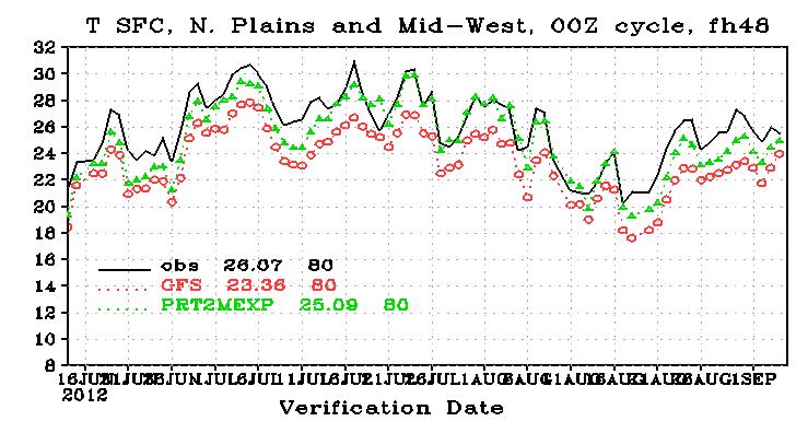
60 US Northern Plains, T2m Verified against Surface Station Observations Early Morning Late afternoon For 2012, ECMWF had almost perfect forecast of surface temperature in the afternoon, but was slightly too warm in the morning. GFS had good T2m forecast in the morning, but was too cold in the afternoon in the warm season. 60


61 US T2m Verified against Surface Station Observations Northwest Northeast GFS and ECMWF were similar in the west GFS is too cold in the east Southwest Southeast 61


62 Temperature Bias, Verified against Rawinsonde Observations, 2012 Annual Mean NH SH Compared to RAOBS 1. GFS was too warm in the upper troposphere and too cold at the tropopause and lower stratosphere. Tropics 2. ECMF was too cold in the stratosphere. 3. ECMWF was better than the GFS in the troposphere but worse in the stratosphere. 62

63 Temperature Bias Verified against RAOBS, Northern Hemisphere, 120hr Fcst 150 hpa 50 hpa 1. It seems GFS cold bias near the tropopause was reduced after the May-2012 Hybrid EnKF implementation. 300 hpa 2. No seasonal variation in the upper troposphere. 3. ECMWF cold bias in the stratosphere was the worst in the first few months. 63
64 Configuration of Major Global High-Res NWP Models (2012) System Analysis Forecast Model Forecast Length and Cycles NCEP GFS ECMWF IFS Hybrid 3DVAR (T382) + EnkF (T254) 4DVAR T1279L91 (T255 inner loops) Semi-implicit Spectral T574L64 (23km, 0.03 hpa) Semi-Lag Spectral T1279L91 (16km, 0.01 hpa) 4 cycles 16 days 2 cycles 10 days upcoming semi-lag T1148 T7999 (2.5km) convection permitting? UKMO Unified Model Hybrid 4DVAR with MOGREPS Ensemble Gridded, 70L (25km; 0.01 hpa) 4 cycles 6 days CMC GEM 3DVAR Semi-lag Gridded (0.3x0.45 deg; 0.1 hpa ) 2 cycles 10 days Non-hydrostatic; 4DVAR JMA GSM 4DVAR Semi-lag spectral T959 L60 ( deg; 0.1 hpa) 4 cycles 9 days (12Z) NAVY NOGAPS NAVDAS-AR 4DVAR Semi-implicit Spectral T319L42 (42km; 0.04hPa) 2 cycles 7.5 days NAVGEM T359L50 semi-lag 64
65 Summary -- Progress Made Hybrid 3DVAR-EnKF implementation improved GFS useful forecast (AC >0.6) by up to 5 hours. Soil Table Update reduced GFS warm season surface temperature cold bias and surface moisture wet bias over the central to western US is a difficult year to forecast. CDAS and CFSR forecast scores (measured by 500hPa HGT AC) dropped in both hemispheres. Still, GFS performed better in 2012 than in 2011, having the largest gain among all major global NWP models. GFS useful forecast (measured by 500hPa HGT AC) reached to 8 days in the NH and 7.6 days in the SH. However, GFS still falls behind ECMWF by 0.2 days in the NH and 0.6 days in the SH. GFS had no bad forecast (AC <0.7) in the NH in This is unprecedented. GFS good forecasts (AC>0.9) reached 37% in the NH and 13% in the SH. However, ECMWF had 61% good forecast in the NH and 52% in the SH. GFS hurricane track forecast for the Atlantic in 2012 was the best among all major global NWP models, despite that ECMWF had better long-lead track forecast for Sandy than did the GFS. In the past ten years, GFS hurricane track and intensity forecast had been greatly improved in both the Atlantic and Pacific basins. GFS CONUS summer precipitation scores, especially for light rains, was degraded since the May 2011 model upgrade. A parameter table used in the soil model was found to be responsible for the degradation. 65
66 Summary -- A few things to consider The gap between GFS and ECMWF in the Southern Hemisphere is much larger than that in the Northern Hemisphere. How to reduce the gap? There are large surface temperature cold biases in summer in the US Northeast. Land model issue or could-radiation issue? Even though the GFS CONUS precipitation skill scores has been improved after the soil table update, it still falls behind ECMWF, UKM and CMC. Compared to RAOBS, GFS has large warm bias in the upper troposphere and large cold bias in the lower stratosphere. Does this imply the GFS tropoapuse is too low? Is it a dynamics problem, or physics problem related to deep convection, high cloud and radiation? 66
Improvements to the NCEP Global and Regional Data Assimilation Systems
 Improvements to the NCEP Global and Regional Data Assimilation Systems Stephen J. Lord Director NCEP Environmental Modeling Center EMC Staff NCEP: where America s climate, weather, and ocean services begin
Next Global Ensemble Forecast System
 Next Global Ensemble Forecast System Yuejian Zhu, Dingchen Hou, Mozheng Wei, Richard Wobus, Jessie Ma, Bo Cui and Shrinivas Moorthi Acknowledgements: Jiayi Peng, Malaquias Pena, Yucheng Song, Yan Luo and
An Overview of Atmospheric Analyses and Reanalyses for Climate
 An Overview of Atmospheric Analyses and Reanalyses for Climate Kevin E. Trenberth NCAR Boulder CO Analysis Data Assimilation merges observations & model predictions to provide a superior state estimate.
Data Assimilation Development for the FV3GFSv2
 Data Assimilation Development for the FV3GFSv2 Catherine Thomas 1, 2, Rahul Mahajan 1, 2, Daryl Kleist 2, Emily Liu 3,2, Yanqiu Zhu 1, 2, John Derber 2, Andrew Collard 1, 2, Russ Treadon 2, Jeff Whitaker
11 days (00, 12 UTC) 132 hours (06, 18 UTC) One unperturbed control forecast and 26 perturbed ensemble members. --
 132 hours (06, 18 UTC) One unperturbed control forecast and 26 perturbed ensemble members. --") APPENDIX 2.2.6. CHARACTERISTICS OF GLOBAL EPS 1. Ensemble system Ensemble (version) Global EPS (GEPS1701) Date of implementation 19 January 2017 2. EPS configuration Model (version) Global Spectral Model
APPENDIX 2.2.6. CHARACTERISTICS OF GLOBAL EPS 1. Ensemble system Ensemble (version) Global EPS (GEPS1701) Date of implementation 19 January 2017 2. EPS configuration Model (version) Global Spectral Model
Masahiro Kazumori, Takashi Kadowaki Numerical Prediction Division Japan Meteorological Agency
 Development of an all-sky assimilation of microwave imager and sounder radiances for the Japan Meteorological Agency global numerical weather prediction system Masahiro Kazumori, Takashi Kadowaki Numerical
Impact Evaluation of New Radiance data, Reduced Thinning and Higher Analysis Resolution in the GEM Global Deterministic Prediction System
 Impact Evaluation of New Radiance data, Reduced Thinning and Higher Analysis Resolution in the GEM Global Deterministic Prediction ITSC-17, Monterey, California Presenter: G. Deblonde*1, Co-authors: A.
Impact of GPS RO Data on the Prediction of Tropical Cyclones
 Impact of GPS RO Data on the Prediction of Tropical Cyclones Ying-Hwa Kuo, Hui Liu, UCAR Ching-Yuang Huang, Shu-Ya Chen, NCU Ling-Feng Hsiao, Ming-En Shieh, Yu-Chun Chen, TTFRI Outline Tropical cyclone
Operational Use of Scatterometer Winds in the JMA Data Assimilation System
 Operational Use of Scatterometer Winds in the Data Assimilation System Masaya Takahashi Numerical Prediction Division, Japan Meteorological Agency () International Ocean Vector Winds Science Team Meeting,
Operational Use of Scatterometer Winds at JMA
 Operational Use of Scatterometer Winds at JMA Masaya Takahashi Numerical Prediction Division, Japan Meteorological Agency (JMA) 10 th International Winds Workshop, Tokyo, 26 February 2010 JMA Outline JMA
Ninth Workshop on Meteorological Operational Systems. Timeliness and Impact of Observations in the CMC Global NWP system
 Ninth Workshop on Meteorological Operational Systems ECMWF, Reading, United Kingdom 10 14 November 2003 Timeliness and Impact of Observations in the CMC Global NWP system Réal Sarrazin, Yulia Zaitseva
Study for utilizing high wind speed data in the JMA s Global NWP system
 Study for utilizing high wind speed data in the JMA s Global NWP system Masami Moriya Numerical Prediction Division, Japan Meteorological Agency (JMA) IOVWST Meeting, Portland, USA, 19-21 May 2015 1 Contents
The Use of GPS Radio Occultation Data for Tropical Cyclone Prediction. Bill Kuo and Hui Liu UCAR
 The Use of GPS Radio Occultation Data for Tropical Cyclone Prediction Bill Kuo and Hui Liu UCAR Current capability of the National Hurricane Center Good track forecast improvements. Errors cut in half
NAVAL RESEARCH LABORATORY. Recent Developments in NWP
 NAVAL RESEARCH LABORATORY Recent Developments in NWP Carolyn Reynolds, Nancy Baker, James Doyle, Douglas Westphal, Melinda Peng Marine Meteorology Division, Simon Chang, Director Naval Research Laboratory,
Improved analyses and forecasts with AIRS retrievals using the Local Ensemble Transform Kalman Filter
 Improved analyses and forecasts with AIRS retrievals using the Local Ensemble Transform Kalman Filter Hong Li, Junjie Liu, and Elana Fertig E. Kalnay I. Szunyogh, E. J. Kostelich Weather and Chaos Group
Analysis of an Observing System Experiment for the Joint Polar Satellite System
 Analysis of an Observing System Experiment for the Joint Polar Satellite System S. Lord, George Gayno 1 and Fanglin Yang 1 24 November 2015 1 I. M. Systems Group at NCEP/EMC 1 Outline The Joint Polar Satellite
Improving Tropical Cyclone Forecasts by Assimilating Microwave Sounder Cloud-Screened Radiances and GPM precipitation measurements
 Improving Tropical Cyclone Forecasts by Assimilating Microwave Sounder Cloud-Screened Radiances and GPM precipitation measurements Hyojin Han a, Jun Li a, Mitch Goldberg b, Pei Wang a,c, Jinlong Li a,
Modelling and Data Assimilation Needs for improving the representation of Cold Processes at ECMWF
 Modelling and Data Assimilation Needs for improving the representation of Cold Processes at ECMWF presented by Gianpaolo Balsamo with contributions from Patricia de Rosnay, Richard Forbes, Anton Beljaars,
TC/PR/RB Lecture 3 - Simulation of Random Model Errors
 TC/PR/RB Lecture 3 - Simulation of Random Model Errors Roberto Buizza (buizza@ecmwf.int) European Centre for Medium-Range Weather Forecasts http://www.ecmwf.int Roberto Buizza (buizza@ecmwf.int) 1 ECMWF
5.3 TESTING AND EVALUATION OF THE GSI DATA ASSIMILATION SYSTEM
 5.3 TESTING AND EVALUATION OF THE GSI DATA ASSIMILATION SYSTEM Kathryn M Newman*, C. Zhou, H. Shao, X.Y. Huang, M. Hu National Center for Atmospheric Research, Boulder, CO Developmental Testbed Center
A two-season impact study of the Navy s WindSat surface wind retrievals in the NCEP global data assimilation system
 A two-season impact study of the Navy s WindSat surface wind retrievals in the NCEP global data assimilation system Li Bi James Jung John Le Marshall 16 April 2008 Outline WindSat overview and working
Operational and research activities at ECMWF now and in the future
 Operational and research activities at ECMWF now and in the future Sarah Keeley Education Officer Erland Källén Director of Research ECMWF An independent intergovernmental organisation established in 1975
ENSO Outlook by JMA. Hiroyuki Sugimoto. El Niño Monitoring and Prediction Group Climate Prediction Division Japan Meteorological Agency
 ENSO Outlook by JMA Hiroyuki Sugimoto El Niño Monitoring and Prediction Group Climate Prediction Division Outline 1. ENSO impacts on the climate 2. Current Conditions 3. Prediction by JMA/MRI-CGCM 4. Summary
Reanalysis applications of GPS radio occultation measurements
 Reanalysis applications of GPS radio occultation measurements Dick Dee, Sakari Uppala, Shinya Kobayashi, Sean Healy ECMWF GRAS SAF Workshop on Applications of GPS radio occultation measurements ECMWF,
WRF Model Simulated Proxy Datasets Used for GOES-R Research Activities
 WRF Model Simulated Proxy Datasets Used for GOES-R Research Activities Jason Otkin Cooperative Institute for Meteorological Satellite Studies Space Science and Engineering Center University of Wisconsin
The role of GPS-RO at ECMWF" ! COSMIC Data Users Workshop!! 30 September 2014! !!! ECMWF
 The role of GPS-RO at ECMWF"!!!! COSMIC Data Users Workshop!! 30 September 2014! ECMWF WE ARE Intergovernmental organisation! 34 Member and Cooperating European states! 270 staff at ECMWF, in Reading,
Impact of Targeted Dropsonde Data on Mid-latitude Numerical Weather Forecasts during the 2011 Winter Storms Reconnaissance Program
 ESRL Impact of Targeted Dropsonde Data on Mid-latitude Numerical Weather Forecasts during the 2011 Winter Storms Reconnaissance Program Presented by Tom Hamill Forecasts and assimilations : Carla Cardinali,
STRONGLY COUPLED ENKF DATA ASSIMILATION
 STRONGLY COUPLED ENKF DATA ASSIMILATION WITH THE CFSV2 Travis Sluka Acknowledgements: Eugenia Kalnay, Steve Penny, Takemasa Miyoshi CDAW Toulouse Oct 19, 2016 Outline 1. Overview of strongly coupled DA
Satellite Assimilation Activities for the NRL Atmospheric Variational Data Assimilation (NAVDAS) and NAVDAS- AR (Accelerated Representer) Systems
 and NAVDAS- AR (Accelerated Representer) Systems") Satellite Assimilation Activities for the NRL Atmospheric Variational Data Assimilation (NAVDAS) and NAVDAS- AR (Accelerated Representer) Systems Marine Meteorology Division, NRL Monterey Nancy Baker,
Satellite Assimilation Activities for the NRL Atmospheric Variational Data Assimilation (NAVDAS) and NAVDAS- AR (Accelerated Representer) Systems Marine Meteorology Division, NRL Monterey Nancy Baker,
Direct assimilation of all-sky microwave radiances at ECMWF
 Direct assimilation of all-sky microwave radiances at ECMWF Peter Bauer, Alan Geer, Philippe Lopez, Deborah Salmond European Centre for Medium-Range Weather Forecasts Reading, Berkshire, UK Slide 1 17
Uncertainty in Operational Atmospheric Analyses. Rolf Langland Naval Research Laboratory Monterey, CA
 Uncertainty in Operational Atmospheric Analyses 1 Rolf Langland Naval Research Laboratory Monterey, CA Objectives 2 1. Quantify the uncertainty (differences) in current operational analyses of the atmosphere
Page 1. Name:
 Name: 1) As the difference between the dewpoint temperature and the air temperature decreases, the probability of precipitation increases remains the same decreases 2) Which statement best explains why
Recent Developments of JMA Operational NWP Systems and WGNE Intercomparison of Tropical Cyclone Track Forecast
 Recent Developments of JMA Operational NWP Systems and WGNE Intercomparison of Tropical Cyclone Track Forecast Chiashi Muroi Numerical Prediction Division Japan Meteorological Agency 1 CURRENT STATUS AND
Impact of assimilating the VIIRS-based CrIS cloudcleared radiances on hurricane forecasts
 Impact of assimilating the VIIRS-based CrIS cloudcleared radiances on hurricane forecasts Jun Li @, Pei Wang @, Jinlong Li @, Zhenglong Li @, Jung-Rim Lee &, Agnes Lim @, Timothy J. Schmit #, and Mitch
Denver International Airport MDSS Demonstration Verification Report for the Season
 Denver International Airport MDSS Demonstration Verification Report for the 2015-2016 Season Prepared by the University Corporation for Atmospheric Research Research Applications Division (RAL) Seth Linden
ECMWF Forecasting System Research and Development
 ECMWF Forecasting System Research and Development Jean-Noël Thépaut ECMWF October 2012 Slide 1 and many colleagues from the Research Department Slide 1, ECMWF The ECMWF Integrated Forecasting System (IFS)
A New Microwave Snow Emissivity Model
 A New Microwave Snow Emissivity Model Fuzhong Weng 1,2 1. Joint Center for Satellite Data Assimilation 2. NOAA/NESDIS/Office of Research and Applications Banghua Yan DSTI. Inc The 13 th International TOVS
The ECMWF Extended range forecasts
 The ECMWF Extended range forecasts Laura.Ferranti@ecmwf.int ECMWF, Reading, U.K. Slide 1 TC January 2014 Slide 1 The operational forecasting system l High resolution forecast: twice per day 16 km 91-level,
4.3.2 Configuration. 4.3 Ensemble Prediction System Introduction
 4.3 Ensemble Prediction System 4.3.1 Introduction JMA launched its operational ensemble prediction systems (EPSs) for one-month forecasting, one-week forecasting, and seasonal forecasting in March of 1996,
Upgrade of JMA s Typhoon Ensemble Prediction System
 Upgrade of JMA s Typhoon Ensemble Prediction System Masayuki Kyouda Numerical Prediction Division, Japan Meteorological Agency and Masakazu Higaki Office of Marine Prediction, Japan Meteorological Agency
Satellite Observations of Greenhouse Gases
 Satellite Observations of Greenhouse Gases Richard Engelen European Centre for Medium-Range Weather Forecasts Outline Introduction Data assimilation vs. retrievals 4D-Var data assimilation Observations
The Texas drought. Kingtse Mo Climate Prediction Center NWS/NCEP/NOAA
 The 2011-2012 Texas drought Kingtse Mo Climate Prediction Center NWS/NCEP/NOAA 1 outline Evolution of the 2011-2012 Texas drought Climatology and historical perspective The 2011 drought Onset Feedback
Assessment of AHI Level-1 Data for HWRF Assimilation
 Assessment of AHI Level-1 Data for HWRF Assimilation Xiaolei Zou 1 and Fuzhong Weng 2 1 Earth System Science Interdisciplinary Center, University of Maryland, College Park, Maryland 2 Satellite Meteorology
THE USE OF SATELLITE OBSERVATIONS IN NWP
 THE USE OF SATELLITE OBSERVATIONS IN NWP The impact of satellite measurements on NWP began in the early 70s with the operational use of global satellite cloud imagery. Nowadays the impact is from active
Numerical Weather Prediction: Data assimilation. Steven Cavallo
 Numerical Weather Prediction: Data assimilation Steven Cavallo Data assimilation (DA) is the process estimating the true state of a system given observations of the system and a background estimate. Observations
Verification of the Seasonal Forecast for the 2005/06 Winter
 Verification of the Seasonal Forecast for the 2005/06 Winter Shingo Yamada Tokyo Climate Center Japan Meteorological Agency 2006/11/02 7 th Joint Meeting on EAWM Contents 1. Verification of the Seasonal
The Use of Hyperspectral Infrared Radiances In Numerical Weather Prediction
 The Use of Hyperspectral Infrared Radiances In Numerical Weather Prediction J. Le Marshall 1, J. Jung 1, J. Derber 1, T. Zapotocny 2, W. L. Smith 3, D. Zhou 4, R. Treadon 1, S. Lord 1, M. Goldberg 1 and
Recent Data Assimilation Activities at Environment Canada
 Recent Data Assimilation Activities at Environment Canada Major upgrade to global and regional deterministic prediction systems (now in parallel run) Sea ice data assimilation Mark Buehner Data Assimilation
Interaction of GPS Radio Occultation with Hyperspectral Infrared and Microwave Sounder Assimilation
 Interaction of GPS Radio Occultation with Hyperspectral Infrared and Microwave Sounder Assimilation Benjamin Ruston, Steve Swadley, Nancy Baker, Rolf Langland Michael Rennie, and Huw Lewis Naval Research
IMPACT STUDIES OF AMVS AND SCATTEROMETER WINDS IN JMA GLOBAL OPERATIONAL NWP SYSTEM
 IMPACT STUDIES OF AMVS AND SCATTEROMETER WINDS IN JMA GLOBAL OPERATIONAL NWP SYSTEM Koji Yamashita Japan Meteorological Agency / Numerical Prediction Division 1-3-4, Otemachi, Chiyoda-ku, Tokyo 100-8122,
DEVELOPMENT OF THE ECMWF FORECASTING SYSTEM
 DEVELOPMENT OF THE ECMWF FORECASTING SYSTEM Jean-Noël Thépaut European Centre for Medium Range Weather Forecasts ECMWF Acknowledgements: Lars Isaksen, Mike Fisher, Yannick Trémolet, Peter Bauer, Adrian
GPC Exeter forecast for winter Crown copyright Met Office
 GPC Exeter forecast for winter 2015-2016 Global Seasonal Forecast System version 5 (GloSea5) ensemble prediction system the source for Met Office monthly and seasonal forecasts uses a coupled model (atmosphere
IMPACT OF IASI DATA ON FORECASTING POLAR LOWS
 IMPACT OF IASI DATA ON FORECASTING POLAR LOWS Roger Randriamampianina rwegian Meteorological Institute, Pb. 43 Blindern, N-0313 Oslo, rway rogerr@met.no Abstract The rwegian THORPEX-IPY aims to significantly
2. Outline of the MRI-EPS
 2. Outline of the MRI-EPS The MRI-EPS includes BGM cycle system running on the MRI supercomputer system, which is developed by using the operational one-month forecasting system by the Climate Prediction
Wind tracing from SEVIRI clear and overcast radiance assimilation
 Wind tracing from SEVIRI clear and overcast radiance assimilation Cristina Lupu and Tony McNally ECMWF, Reading, UK Slide 1 Outline Motivation & Objective Analysis impact of SEVIRI radiances and cloudy
The Atmospheric Circulation
 The Atmospheric Circulation Vertical structure of the Atmosphere http://www.uwsp.edu/geo/faculty/ritter/geog101/textbook/atmosphere/atmospheric_structure.html The global heat engine [courtesy Kevin Trenberth,
The Developmental Testbed Center: Update on Data Assimilation System Testing and Community Support
 93rd AMS Annual Meeting/17th IOAS-AOLS/3rd Conference on Transition of Research to Operations, Austin, TX, Jan 6-10, 2013 The Developmental Testbed Center: Update on Data Assimilation System Testing and
Weather Outlook: 2015 Growing Season
 Weather Outlook: 2015 Growing Season Leon F. Osborne Chester Fritz Distinguished Professor Regional Weather Information Center University of North Dakota Grand Forks, North Dakota Why Should We Be Concerned?
Motivation & Goal. We investigate a way to generate PDFs from a single deterministic run
 Motivation & Goal Numerical weather prediction is limited by errors in initial conditions, model imperfections, and nonlinearity. Ensembles of an NWP model provide forecast probability density functions
Saharan Dust Induced Radiation-Cloud-Precipitation-Dynamics Interactions
 Saharan Dust Induced Radiation-Cloud-Precipitation-Dynamics Interactions William K. M. Lau NASA/GSFC Co-authors: K. M. Kim, M. Chin, P. Colarco, A. DaSilva Atmospheric loading of Saharan dust Annual emission
Section 13-1: Thunderstorms
 Section 13-1: Thunderstorms Chapter 13 Main Idea: The intensity and duration of thunderstorms depend on the local conditions that create them. Air-mass thunderstorm Mountain thunderstorm Sea-breeze thunderstorm
2012 AHW Stream 1.5 Retrospective Results
 2012 AHW Stream 1.5 Retrospective Results Ryan D. Torn, Univ. Albany, SUNY Chris Davis, Wei Wang, Jimy Dudhia, Tom Galarneau, Chris Snyder, James Done, NCAR/NESL/MMM Overview Since participation in HFIP
The benefits and developments in ensemble wind forecasting
 The benefits and developments in ensemble wind forecasting Erik Andersson Slide 1 ECMWF European Centre for Medium-Range Weather Forecasts Slide 1 ECMWF s global forecasting system High resolution forecast
Lecture #18 (April 12, 2010, Monday) Tropical Storms & Hurricanes Part 3. Hurricane Floyd September 15, 1999
 Tropical Storms & Hurricanes Part 3. Hurricane Floyd September 15, 1999") Lecture #18 (April 12, 2010, Monday) Tropical Storms & Hurricanes Part 3 Hurricane Floyd September 15, 1999 Tropical Cyclone Names Names are given to distinguish storms and for ease of communication. Names
Lecture #18 (April 12, 2010, Monday) Tropical Storms & Hurricanes Part 3 Hurricane Floyd September 15, 1999 Tropical Cyclone Names Names are given to distinguish storms and for ease of communication. Names
University of Miami/RSMAS
 Observing System Simulation Experiments to Evaluate the Potential Impact of Proposed Observing Systems on Hurricane Prediction: R. Atlas, T. Vukicevic, L.Bucci, B. Annane, A. Aksoy, NOAA Atlantic Oceanographic
Coupled data assimilation for climate reanalysis
 Coupled data assimilation for climate reanalysis Dick Dee Climate reanalysis Coupled data assimilation CERA: Incremental 4D-Var ECMWF June 26, 2015 Tools from numerical weather prediction Weather prediction
The Improvement of JMA Operational Wave Models
 The Improvement of JMA Operational Wave Models Toshiharu Tauchi Nadao Kohno * Mika Kimura Japan Meteorological Agency * (also) Meteorological Research Institute, JMA 10 th International Workshop on Wave
Enhancing Weather Forecasts via Assimilating SMAP Soil Moisture and NRT GVF
 CICS Science Meeting, ESSIC, UMD, 2016 Enhancing Weather Forecasts via Assimilating SMAP Soil Moisture and NRT GVF Li Fang 1,2, Christopher Hain 1,2, Xiwu Zhan 2, Min Huang 1,2 Jifu Yin 1,2, Weizhong Zheng
IMPACT OF GROUND-BASED GPS PRECIPITABLE WATER VAPOR AND COSMIC GPS REFRACTIVITY PROFILE ON HURRICANE DEAN FORECAST. (a) (b) (c)
 (b) (c)") 9B.3 IMPACT OF GROUND-BASED GPS PRECIPITABLE WATER VAPOR AND COSMIC GPS REFRACTIVITY PROFILE ON HURRICANE DEAN FORECAST Tetsuya Iwabuchi *, J. J. Braun, and T. Van Hove UCAR, Boulder, Colorado 1. INTRODUCTION
9B.3 IMPACT OF GROUND-BASED GPS PRECIPITABLE WATER VAPOR AND COSMIC GPS REFRACTIVITY PROFILE ON HURRICANE DEAN FORECAST Tetsuya Iwabuchi *, J. J. Braun, and T. Van Hove UCAR, Boulder, Colorado 1. INTRODUCTION
The Impact of Observational data on Numerical Weather Prediction. Hirokatsu Onoda Numerical Prediction Division, JMA
 The Impact of Observational data on Numerical Weather Prediction Hirokatsu Onoda Numerical Prediction Division, JMA Outline Data Analysis system of JMA in Global Spectral Model (GSM) and Meso-Scale Model
The 2009 Hurricane Season Overview
 The 2009 Hurricane Season Overview Jae-Kyung Schemm Gerry Bell Climate Prediction Center NOAA/ NWS/ NCEP 1 Overview outline 1. Current status for the Atlantic, Eastern Pacific and Western Pacific basins
Effects of a convective GWD parameterization in the global forecast system of the Met Office Unified Model in Korea
 Effects of a convective GWD parameterization in the global forecast system of the Met Office Unified Model in Korea Young-Ha Kim 1, Hye-Yeong Chun 1, and Dong-Joon Kim 2 1 Yonsei University, Seoul, Korea
Enhanced Predictability During Extreme Winter Flow Regimes
 Enhanced Predictability During Extreme Winter Flow Regimes Ryan N. Maue (WeatherBELL Analytics - Atlanta) maue@weatherbell.com ECMWF UEF 2016 Reading, UK June 6 9, 2016 Where does forecast verification
The GNSS-RO Data Impact on the Typhoon Predictions by MPAS-GSI Model
 The GNSS-RO Data Impact on the Typhoon Predictions by MPAS-GSI Model 1 Shu-Ya Chen, 1,2 Cheng-Peng Shih, 2,3 Ching-Yuang Huang, 2 Wen-Hsin Teng, and 1 Yang-Cheng Huang 1 GPS Science and Application Research
Numerical Weather prediction at the European Centre for Medium-Range Weather Forecasts
 Numerical Weather prediction at the European Centre for Medium-Range Weather Forecasts Time series curves 500hPa geopotential Correlation coefficent of forecast anomaly N Hemisphere Lat 20.0 to 90.0 Lon
Impact of METOP ASCAT Ocean Surface Winds in the NCEP GDAS/GFS and NRL NAVDAS
 Impact of METOP ASCAT Ocean Surface Winds in the NCEP GDAS/GFS and NRL NAVDAS COAMPS @ Li Bi 1,2 James Jung 3,4 Michael Morgan 5 John F. Le Marshall 6 Nancy Baker 2 Dave Santek 3 1 University Corporation
Application of Himawari-8 AHI Data to the GOES-R Rainfall Rate Algorithm
 Application of Himawari-8 AHI Data to the GOES-R Rainfall Rate Algorithm Yaping Li 1, Robert Kuligowski 2 and Yan Hao 1 1. IMSG at NOAA/NESDIS/STAR 2. NOAA/NESDIS/STAR, College Park, MD 1 GOES-R Baseline
Hybrid variational-ensemble data assimilation. Daryl T. Kleist. Kayo Ide, Dave Parrish, John Derber, Jeff Whitaker
 Hybrid variational-ensemble data assimilation Daryl T. Kleist Kayo Ide, Dave Parrish, John Derber, Jeff Whitaker Weather and Chaos Group Meeting 07 March 20 Variational Data Assimilation J Var J 2 2 T
Seasonal forecasting activities at ECMWF
 Seasonal forecasting activities at ECMWF An upgraded ECMWF seasonal forecast system: Tim Stockdale, Stephanie Johnson, Magdalena Balmaseda, and Laura Ferranti Progress with C3S: Anca Brookshaw ECMWF June
The impact of assimilation of microwave radiance in HWRF on the forecast over the western Pacific Ocean
 The impact of assimilation of microwave radiance in HWRF on the forecast over the western Pacific Ocean Chun-Chieh Chao, 1 Chien-Ben Chou 2 and Huei-Ping Huang 3 1Meteorological Informatics Business Division,
The JRA-55 Reanalysis: quality control and reprocessing of observational data
 The JRA-55 Reanalysis: quality control and reprocessing of observational data Kazutoshi Onogi On behalf of JRA group Japan Meteorological Agency 29 October 2014 EASCOF 1 1. Introduction 1. Introduction
ERA-CLIM: Developing reanalyses of the coupled climate system
 ERA-CLIM: Developing reanalyses of the coupled climate system Dick Dee Acknowledgements: Reanalysis team and many others at ECMWF, ERA-CLIM project partners at Met Office, Météo France, EUMETSAT, Un. Bern,
Tropical cyclone simulations and predictions with GFDL s prototype global cloud resolving model
 Tropical cyclone simulations and predictions with GFDL s prototype global cloud resolving model S.-J. Lin and GFDL model development teams NOAA/Geophysical Fluid Dynamics Laboratory Workshop on High-Resolution
Water Balance in the Murray-Darling Basin and the recent drought as modelled with WRF
 18 th World IMACS / MODSIM Congress, Cairns, Australia 13-17 July 2009 http://mssanz.org.au/modsim09 Water Balance in the Murray-Darling Basin and the recent drought as modelled with WRF Evans, J.P. Climate
The EMC Mission.. In response to operational requirements:
 The EMC Mission.. In response to operational requirements: Maintain operational model suite The scientific correctness and integrity of operational forecast modeling systems Modify current operational
5. General Circulation Models
 5. General Circulation Models I. 3-D Climate Models (General Circulation Models) To include the full three-dimensional aspect of climate, including the calculation of the dynamical transports, requires
Aircraft-based Observations: Impact on weather forecast model performance
 Aircraft-based Observations: Impact on weather forecast model performance Stephen S. Weygandt Eric James, Stan Benjamin, Bill Moninger, Brian Jamison, Geoff Manikin* NOAA Earth System Research Laboratory
Application and verification of ECMWF products 2016
 Application and verification of ECMWF products 2016 Icelandic Meteorological Office (www.vedur.is) Bolli Pálmason and Guðrún Nína Petersen 1. Summary of major highlights Medium range weather forecasts
Feature-tracked 3D Winds from Satellite Sounders: Derivation and Impact in Global Models
 Feature-tracked 3D Winds from Satellite Sounders: Derivation and Impact in Global Models David Santek, Anne-Sophie Daloz 1, Samantha Tushaus 1, Marek Rogal 1, Will McCarty 2 1 Space Science and Engineering
The NOAA Operational Numerical Guidance System: Recent Changes and Moving Forward. William. M. Lapenta Acting Director Environmental Modeling Center
 AMS Future of the Weather Enterprise 11/27/12 1 N C E P The NOAA Operational Numerical Guidance System: Recent Changes and Moving Forward William. M. Lapenta Acting Director Environmental Modeling Center
UPDATE OF REGIONAL WEATHER AND SMOKE HAZE (December 2017)
") UPDATE OF REGIONAL WEATHER AND SMOKE HAZE (December 2017) 1. Review of Regional Weather Conditions for November 2017 1.1 In November 2017, Southeast Asia experienced inter-monsoon conditions in the first
UPDATE OF REGIONAL WEATHER AND SMOKE HAZE (December 2017) 1. Review of Regional Weather Conditions for November 2017 1.1 In November 2017, Southeast Asia experienced inter-monsoon conditions in the first
3. As warm, moist air moves into a region, barometric pressure readings in the region will generally 1. decrease 2. increase 3.
 Teacher: Mr. Prizzi Castle Learning Review 1 1. Which process most directly results in cloud formation? 1. condensation 3. precipitation 2. transpiration 4. radiation 2. An air mass originating over north
Convective-scale NWP for Singapore
 Convective-scale NWP for Singapore Hans Huang and the weather modelling and prediction section MSS, Singapore Dale Barker and the SINGV team Met Office, Exeter, UK ECMWF Symposium on Dynamical Meteorology
Hypothesis for ESPC Demo #1: Flow-followingfinite-volume. Icosahedral
 Blocking Error in 10 day to 1 year Global Model Forecasts, Dependency on Resolution and Numerics Stan Benjamin, Shan Sun, Rainer Bleck, John Brown NOAA Earth System Research Laboratory, Boulder CO USA
State of the art of wind forecasting and planned improvements for NWP Helmut Frank (DWD), Malte Mülller (met.no), Clive Wilson (UKMO)
, Malte Mülller (met.no), Clive Wilson (UKMO)") State of the art of wind forecasting and planned improvements for NWP Helmut Frank (DWD), Malte Mülller (met.no), Clive Wilson (UKMO) thanks to S. Bauernschubert, U. Blahak, S. Declair, A. Röpnack, C.
State of the art of wind forecasting and planned improvements for NWP Helmut Frank (DWD), Malte Mülller (met.no), Clive Wilson (UKMO) thanks to S. Bauernschubert, U. Blahak, S. Declair, A. Röpnack, C.
GSI Data Assimilation System Support and Testing Activities: 2013 Annual Update
 14Th Annual WRF Users Workshop, Boulder, CO, June 24-28, 2013 GSI Data Assimilation System Support and Testing Activities: 2013 Annual Update Hui Shao1, Ming Hu2, Chunhua Zhou1, Kathryn Newman1, Mrinal
Applications of future GEO advanced IR sounder for high impact weather forecasting demonstration with regional OSSE
 Applications of future GEO advanced IR sounder for high impact weather forecasting demonstration with regional OSSE Jun Li @, Tim Schmit &, Zhenglong Li @, Feng Zhu @*, Pei Wang @*, Agnes Lim @, and Robert
Land Analysis in the NOAA CFS Reanalysis. Michael Ek, Ken Mitchell, Jesse Meng Helin Wei, Rongqian Yang, and George Gayno
 Land Analysis in the NOAA CFS Reanalysis Michael Ek, Ken Mitchell, Jesse Meng Helin Wei, Rongqian Yang, and George Gayno 1 Outline CFS Reanalysis execution Land surface model upgrade from OSU to Noah LIS/GLDAS
Ting Lei, Xuguang Wang University of Oklahoma, Norman, OK, USA. Wang and Lei, MWR, Daryl Kleist (NCEP): dual resolution 4DEnsVar
: dual resolution 4DEnsVar") GSI-based four dimensional ensemble-variational (4DEnsVar) data assimilation: formulation and single resolution experiments with real data for NCEP GFS Ting Lei, Xuguang Wang University of Oklahoma, Norman,
GSI-based four dimensional ensemble-variational (4DEnsVar) data assimilation: formulation and single resolution experiments with real data for NCEP GFS Ting Lei, Xuguang Wang University of Oklahoma, Norman,
OSSE to infer the impact of Arctic AMVs extracted from highly elliptical orbit imagery
 OSSE to infer the impact of Arctic AMVs extracted from highly elliptical orbit imagery L. Garand 1 Y. Rochon 1, S. Heilliette 1, J. Feng 1, A.P. Trishchenko 2 1 Environment Canada, 2 Canada Center for