Sentinel-1/-2/-3 Overview and Status
|
|
|
- Philippa Rose
- 5 years ago
- Views:
Transcription
1 Sentinel-1/-2/-3 Overview and Status Meeting with Austrian Partners 27 May 2014, Vienna Slide 1


2 Copernicus Components Coordinators: Partners: Space Component Industries National Space Agencies Private companies Eumetsat Overall Programme Coordination Services Component Service operators In-Situ Component National environmental agencies Slide 2 2
3 Sentinel Deployment Schedule Access to Copernicus Contributing Missions data Sentinel-1 A/B/ C/D Sentinel-1 SG A/B Sentinel-2 A/B/C/D Sentinel-2 SG A/B Sentinel-3 A/B/C/D Sentinel-3 SG A/B Sentinel-4 A/B Sentinel-5 Precursor Sentinel-5 A/B/C Sentinel-6 [Jason-CS] A/B Sentinel-6 [Jason-CS] Next Generation Slide 3
 Multi-spectral")
 Ocean and land monitoring Wide-swath ocean color, vegetation,")

 Low inclination Altimetry Sea-level,")
4 Copernicus Space Component: Dedicated Missions Sentinel-1 (A/B/C/D) SAR imaging All weather, day/night applications, interferometry Sentinel-2 (A/B/C/D) Multi-spectral imaging Land applications: urban, forest, agriculture, Continuity of Landsat, SPOT Sentinel-3 (A/B/C/D) Ocean and land monitoring Wide-swath ocean color, vegetation, sea/land surface temperature, altimetry Sentinel-4 (A/B) Geostationary atmospheric Atmospheric composition monitoring, transboundary pollution Sentinel-5 precursor Low-orbit atmospheric Sentinel-5 (A/B/C) Low-orbit atmospheric Atmospheric composition monitoring Slide 4 Sentinel-6 - Jason-CS (A/B) Low inclination Altimetry Sea-level, wave height and marine wind speed 4


 maritime")
 wind, wave, current")

 support to emergency / risk")
 and humanitarian aid in crisis")
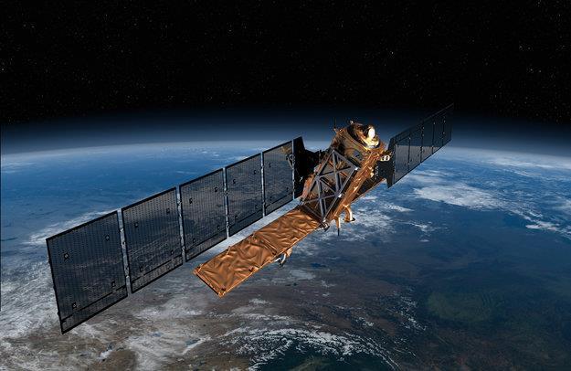
5 Sentinel 1: C-band SAR mission Data continuity of ERS and ENVISAT missions Copernicus radar imaging mission for ocean, land, emergency Applications: monitoring sea ice zones and the arctic environment surveillance of marine environment (e.g. oil spill monitoring) maritime security (e.g. ship detection) wind, wave, current monitoring monitoring of land surface motion (subsidence, landslide, tectonics, volcanoes, etc.) support to emergency / risk management (e.g. flooding, etc.) and humanitarian aid in crisis situations mapping of land surfaces: forest, water and soil, agriculture, etc.

6 Sentinel-1: a wide range of applications in very different thematic domains


")
7 Sentinel-1: Mission Profile Two satellites C-band Radar instrument Sun-synchronous orbit at 693 km altitude Inclination: years lifetime Consumables for 12 years Mean LST: 18:00h at ascending node 12-day repeat cycle at Equator (with 1 satellite) 96h operative autonomy
 of 1400 Gbit Two X-band RF channels for data")

8 Sentinel 1 Technical Facts C-Band SAR instrument operates at centre frequency of GHz On-board data storage capacity (mass memory) of 1400 Gbit Two X-band RF channels for data downlink with 2 X 260 Mbps On-board data compression using Flexible Dynamic Block Adaptive Quantization Optical Communication Payload for data transfer via laser link with the GEO European Data Relay Satellite (ERDS) system Slide 8


9 Satellite External Views Deployed Configuration Soyuz ST 3.4 m 9 Stowed Configuration Slide 9

10 Sentinel-1 SAR imaging modes 4 mutually exclusive SAR modes with different resolution and coverage Polarisation schemes for IW, EW & SM: single polarisation: HH or VV dual polarisation: HH+HV or VV+VH Wave mode: HH or VV SAR duty cycle per orbit: up to 25 min in any of the imaging modes up to 74 min in Wave mode Slide 10 Main modes of operations: - IW over land and coastal waters (normally VV or VV-VH polarization) - EW over extended sea (VV or VV-VH) and sea-ice (HH or HH-HV) areas - WV over open oceans
 6 days repeat cycle (with 2 satellites) 2 x 260 Mb/s downlink data rate 7 years")
 35 days repeat cycle Up to 100 Mb/s")
11 Sentinel-1 Quantum Leap Sentinel-1 10 m ground range resolution (stripmap mode) 250 km swath width (Interferometric wide swath mode) 6 days repeat cycle (with 2 satellites) 2 x 260 Mb/s downlink data rate 7 years design lifetime (consumables for 12 years) Optical link to downlink the data to EDRS. Envisat ASAR 20 m ground range resolution 100 km swath width (Imaging mode) 35 days repeat cycle Up to 100 Mb/s space to ground data rate 5 years design lifetime

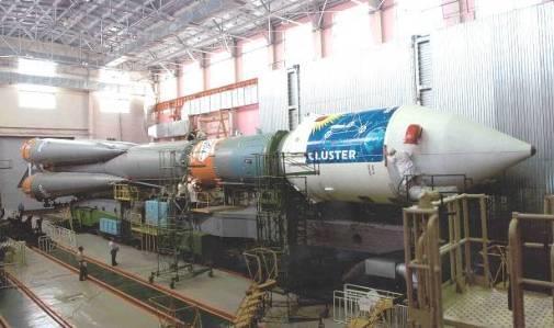
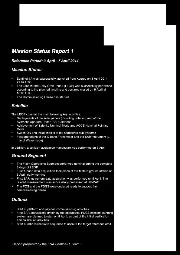
12 Launch Sentinel-1A 3 April 2014 Kourou spaceport Soyuz-2 rocket New era of Earth observation

13 Sentinel-1A Satellite Status Commissioning Phase on-going Not yet in operational orbit Lower injection orbit; longer duration of reference orbit acquisition phase Calibration for operational data on-going Characterisation of propulsion sub-system has been finalised Satellite in Nominal Mission Mode All sub-systems fully functional /working on prime units No major anomalies Performance above specifications

14 Sentinel-1A GS Status Overall PDGS status and performance nominal Regular X-band downlink performed via Matera and Svalbard stations since 15 April SAR data systematically processed at UK-PAC to Level-1 SLC and GRD products; systematically circulated to German PAC for Long Term Archiving

15 Sentinel-1A Data Access Status In routine phase, Sentinel-1A will generate approximately 1.8 Terabytes of products a day Users have free and open access to Copernicus dedicated Sentinel products and Copernicus service information Initial samples of Sentinel-1A not-yet-qualified products are available to all users since 9 May Users can self register online at users have self-registered. (This is in addition to the Copernicus core users already registered on CSCDA) Since the opening on 9 May, 684 products have been downloaded, corresponding to a volume of 1.4 TB


16 Weekly Mission Status Reports
 Spatial resolution: 10, 20 and 60 m and 290 km swath 5 days repeat cycle at Equator with 2 satellites (10 days with 1) Sun synchronous orbit at 786 km mean")
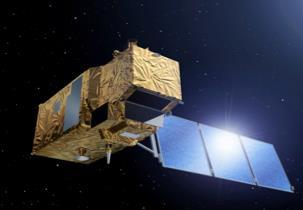
17 Sentinel 2: Superspectral imaging mission Applications: Land cover, vegetation Agriculture Forestry Inland waters/coastal zones Risk mapping Etc. 13 spectral bands (VIS, NIR & SWIR) Spatial resolution: 10, 20 and 60 m and 290 km swath 5 days repeat cycle at Equator with 2 satellites (10 days with 1) Sun synchronous orbit at 786 km mean altitude 7 years design life time, consumables for 12 years


 Optical")


")
18 A variety of applications will be served by Sentinel-2 Forests & Carbon, Vegetation monitoring/change (Credit: GEO-FCT/Tropforest project) European, African coverages for land cover classification/corine IMAGE2006, IMAGE2009 etc. (Credit: Euromap, DMCii-Deimos, USGS) Repetitive coverages/change detection: Urban Atlas (Credit: EUSI, SIRS) Global Land cover Land use (Credit: GLOBCover ESA) Optical observations with 13 spectral bands at 10-60m resolution Support a wide range of applications Emergency management: flooding (Credit: SAFER, DLR) Geology (Credit: USGS) Coastal zones/bathymetry (Credit: R. Merton et al.) Glaciers and ice (Credit: LIMA Project)


19 Sentinel-2 swath SPOT4 60 x 60 km x 2 IRS P6 LISS III 141x141 km Landsat ETM+ 180 x 172 km Sentinel x 290 km High revisit time assured by twin satellite observations performed over a very large swath
20 Sentinel-2 Observation scenario Baseline in full operations is systematic acquisition of: All land surfaces (-56 and +84 latitude); Major (greater than 100 km 2 size) and EU islands; Coastal (20km off the coast) inland waters, Mediterranean Sea and all closed seas; Cal/Val sites. Like for Sentinel-1, a gradual ramp-up will be defined for Sentinel-2, increasing/improving gradually the service to users in a stepwise approach Slide 20

21 There will be gradual ramp-up until the Full Operational scenario is reached Start of ramp-up phase Assuming availability of 2 downlink stations out of 4 Ensuring coverage of global Cal/Val needs Ensuring COPERNICUS CORE datasets needs for Europe/Africa systematically Ensuring maximum coverage/orbit length for GRI generation End of ramp-up Slide 21
22 Evolutions of/changes to the Sentinel-2 Observation Plan Additional observation requirements have been received from Copernicus Services, Member States (collaborative GS), the science community, workshops etc.e.g.: Coverage of oceans Coverage of coral reefs on global scale Night-time observations Antarctica coverage Coverage of coastal waters (beyond the MRD coast region coverage) such requirements are taken onboard for mission planning simulations. Their inclusion will follow the process between European Commission and ESA to handle the evolution of the Copernicus Space Component. Slide 22
23 Sentinel-2 Bands and Resolutions VNIR FPA B1 SWIR SWIR VIS NIR FPA SWIR VNIR Visible Atmospheric correction channels B9 B10 60 m Aerosols Water-vapour Cirrus B5 B7 B8a Snow / ice / cloud discrimination Vegetation status 20 m Vegetation Red-edge B6 B11 B12 10 m Continuity with SPOT5 multispectral 400 nm B2 B3 B4 B8 600 nm 800 nm 1000 nm 1200 nm 1400 nm 1600 nm 1800 nm 2000 nm 2200 nm 2400 nm Slide 23
24 Issues solved & Latest achievements Some problems: Contamination of the SWIR FPA by droplets requiring long & tedious cleaning. 6 MSI large de-bonded inserts required customised re-enforcement by Titanium flanges. Significant progress: All MSI performance & qualification tests were successfully completed in April 2014 by AirbusDS France. The MSI PFM is on its way to AirbusDS Germany 6 days ago. Platforms integration & test campaign: all flight hardware integrated for the environment test campaign. Qualification of flight software & completion of most subsystem tests. Decision to launch S2A with VEGA: PMAR closed, FMA ongoing (satellitelauncher compatibility tests in September 2014). The S2 Ground System Validation & In Orbit Commissioning are being jointly defined by the ESA Project and Ground System teams (with the support of CNES Slide 24 for Image Quality). 24

 OCP")


 Slide 25 S2B")
25 Sentinel-2A: 1 year to launch MSI PFM integration Satellite arrival at IABG(D) OCP FM integration QAR Board Launch readiness (VEGA) System IOCR S2A 21 May 14 8 Aug Nov Mar Apr Jul. 15 MSI integration, Satellite final functional tests Satellite environmental qualification tests MSI integration FAR Board Launch readiness (ROCKOT) Slide 25 S2B 15 Jul Mar Apr

26 Sentinel-2 development status Slide 26 Sentinel-2A and -2B platforms at AirbusDS Germany 26

27 Sentinel 3: Ocean & global land mission Applications: Sea/land colour data and surface temperature sea surface and land ice topography Sun synchronous orbit at km mean altitude over geoid 27 days repeat cycle for the topography package, < 3 days for OLCI and < 2 days for SLSTR 7 years design life time, consumables for 12 years


")
 Atmospheric aerosol")
 Slide 28 Fire")

28 S3 Background: Primary Objectives Ocean colour products (Credit: MyOcean) Sea Surface Height products (Credit: CLS) Sea Surface Temperature products (Credit: Met Office) Along track wind and wave products (Credit: AVISO) sea Land cover products (Credit: ESA) Sea Ice products (Credit: UCL) Atmospheric aerosol products (Credit: GlobAerosol) Slide 28 Fire products (Credit: ESA World Fire atlas) User parameters derived from L1b products (Credit: GEO)
 MicroWave Radiometer (Bi-frequency) Precise Orbit Determination (POD) including GNSS Receiver DORIS Laser")
29 Sentinel 3 payload Optical Mission Payload Ocean and Land Color Instrument (OLCI) (continuity of MERIS) Sea and Land Surface Temperature Radiometer (SLSTR) (continuity of ATSR-AATSR) Topography Mission Payload Ku-/C-band Synthetic Aperture Radar Altimeter (SRAL) MicroWave Radiometer (Bi-frequency) Precise Orbit Determination (POD) including GNSS Receiver DORIS Laser Retro-Reflector
 for instrument integration -")

30 Sentinel-3 Status: General Development status - Most equipment required for Sentinel-3A and - 3B already delivered - Sentinel-3A Satellite integration well advanced S3A Satellite being prepared at Prime facilities (Cannes-F) for instrument integration - Sentinel-3B Platform integration almost completed Launch of the Sentinel-3A currently foreseen for June 2015 FAR of the Sentinel-3B satellite planned approx. 1 year after S3A FAR S3B Platform undergoing electrical integration at Platform Responsible facilities in Rome (I) Slide 30 30

31 On the web: Sentinel Online web site: Sentinel-1 sample products: Thank you!
Sentinel-1 Mission Status
 Sentinel-1 Mission Status Pierre Potin, Sentinel-1 Mission Manager 5TH GEOGLAM RAPP Workshop 16-17 May 2017, ESRIN Sentinel-1: Copernicus radar imaging mission for ocean, land, emergency Part of the Copernicus
Towards eenvironment Prague, March GMES Space Component. Josef Aschbacher Head, ESA GMES Space Office
 Towards eenvironment Prague, 25-27 March 2009 GMES Space Component Josef Aschbacher Head, ESA GMES Space Office Prague from Space Segment 2 05 Nov 2003 CNES 2003 GISAT 2007 ESA GSELAND GMES is an EU led
Copernicus Space Component
 Copernicus Space Component Core and Collaborative Ground Segment, Operations Concept, Data Access Simon.Jutz (@esa.int) Head, Copernicus Space Office European Space Agency, Earth Observation Programmes
sentinel-3 A BIGGER PICTURE FOR COPERNICUS
 sentinel-3 A BIGGER PICTURE FOR COPERNICUS SATELLITES TO SERVE By providing a set of key information services for a wide range of practical applications, Europe s Copernicus programme has been put in place
Sentinel (-1/-2/-3) Status
 Status") Sentinel (-1/-2/-3) Status Pierre Potin, ESA CCI collocation, 6 February 2014, ESRIN Slide 1 Outline - Sentinel (-1 / -2 / -3) Status - Sentinel-1 Observation Concept Overview - Sentinel-1 Mission Ramp-Up
Sentinel (-1/-2/-3) Status Pierre Potin, ESA CCI collocation, 6 February 2014, ESRIN Slide 1 Outline - Sentinel (-1 / -2 / -3) Status - Sentinel-1 Observation Concept Overview - Sentinel-1 Mission Ramp-Up
sentinel-2 COLOUR VISION FOR COPERNICUS
 sentinel-2 COLOUR VISION FOR COPERNICUS SATELLITES TO SERVE By providing a set of key information services for a wide range of practical applications, Europe s Copernicus programme is providing a step
Sentinel-1 Mission Status
 Sentinel-1 Mission Status Pierre Potin, Sentinel-1 Mission Manager, ESA Luca Martino, Technical Support Engineer, ESA... and the Sentinel-1 operations team PSTG SAR Coordination Working Group 14 December
Sentinels and Waves. GMES Sentinel-1 SAR GMES Sentinel-3 Altimeter
 Sentinels and Waves GMES Sentinel-1 SAR GMES Sentinel-3 Altimeter Simon Pinnock, ESA-ESRIN, Frascati, Italy with help from Craig Donlon (ESTEC) & Nuno Miranda (ESRIN) et al. GMES Space Component: dedicated
UN COPUOS 52 nd session of the Scientific and Technical Subcommittee. COPERNICUS - an European Achievement. S. Jutz Head, ESA Copernicus Space Office
 UN COPUOS 52 nd session of the Scientific and Technical Subcommittee COPERNICUS - an European Achievement S. Jutz Head, ESA Copernicus Space Office 11 Feb 2015, Vienna 1 2 What is Copernicus? European
Opportunities for advanced Remote Sensing; an outsider s perspective
 Opportunities for advanced Remote Sensing; an outsider s perspective Ramon Hanssen Delft University of Technology 1 Starting questions Can we do more with the data we are already acquire? What s in stock
Copernicus Today and Tomorrow GEO Week Group on Earth Observation Geneva, 16 January 2014 The Copernicus Space Infrastructure
 Copernicus Today and Tomorrow GEO Week Group on Earth Observation Geneva, 16 January 2014 The Copernicus Space Infrastructure Thomas Beer, Policy Coordinator, Copernicus Space Office, ESA-ESRIN, Frascati
HY-2A Satellite User s Guide
 National Satellite Ocean Application Service 2013-5-16 Document Change Record Revision Date Changed Pages/Paragraphs Edit Description i Contents 1 Introduction to HY-2 Satellite... 1 2 HY-2 satellite data
CopernicusEU. the EU's Earth Observation Programme. Sara Zennaro Atre Delegation of the European Union to Japan
 Copernicus the EU's Earth Observation Programme Sara Zennaro Atre Delegation of the European Union to Japan Status Overview, Sept 2016 & Ocean Policies Seminar 4 October 2016 ollow us on: Copernicus EU
Copernicus Space Component Status & Evolution
 Copernicus Space Component Status & Evolution ESCAP, Bangkok 09 October 2017 Simon Jutz Head of the ESA Copernicus Space Office Directorate of Earth Observation Programmes 28 satellites in development
Julia Figa-Saldaña & Klaus Scipal
 Julia Figa-Saldaña & Klaus Scipal julia.figa@eumetsat.int klaus.scipal@esa.int Meeting, Outline MetOp/EPS status MetOp/EPS Second Generation status 2016 scatterometer conference Other European ocean programme
Status of the Sentinel-5 Precursor Presented by C. Zehner S5p, S4, and S5 Missions Manager - ESA
 Status of the Sentinel-5 Precursor Presented by C. Zehner S5p, S4, and S5 Missions Manager - ESA European response to global needs: to manage the environment, to mitigate the effects of climate change
Infrastructure monitoring using SAR interferometry
 Infrastructure monitoring using SAR interferometry Hossein Nahavandchi Roghayeh Shamshiri Norwegian University of Science and Technology (NTNU), Department of Civil and Environmental Engineering Geodesy
Emergency Management Service (EMS) mapping
 mapping") GMES Emergency Management Service (EMS) mapping Frédéric BASTIDE GMES unit, European Commission UN-SPIDER Expert Meeting: "Crowdsource Mapping for Disaster Risk Management and Emergency Response" 3-5 December,
GMES Emergency Management Service (EMS) mapping Frédéric BASTIDE GMES unit, European Commission UN-SPIDER Expert Meeting: "Crowdsource Mapping for Disaster Risk Management and Emergency Response" 3-5 December,
A.2 Copernicus, Sentinels und Meer. Daten der Sentinel Satelliten - Datenprodukte und Anwendungsbeispiele
 Nationales Forum fuer Fernerkundung und Copernicus, 3. 5. Nov 2015, Berlin A.2 Copernicus, Sentinels und Meer Daten der Sentinel Satelliten - Datenprodukte und Anwendungsbeispiele Simon Jutz, Head, ESA
EUMETSAT STATUS AND PLANS
 1 EUM/TSS/VWG/15/826793 07/10/2015 EUMETSAT STATUS AND PLANS François Montagner, Marine Applications Manager, EUMETSAT WMO Polar Space Task Group 5 5-7 October 2015, DLR, Oberpfaffenhofen PSTG Strategic
ESA UNCLASSIFIED For Official Use
 First revision (draft for Commission review) 15.06.2015 See track changes Second update following comments from Commission 15.08.2015 See track changes Third and final update following final comments from
Copernicus Overview and Emergency Management Service
 Copernicus Overview and Emergency Management Service Frédéric BASTIDE European Commission Open informal session of the United Nations Inter-Agency Meeting on Outer Space Activities 12 March 2013, Geneva
THE COPERNICUS PROGRAMME
 THE COPERNICUS PROGRAMME Jolyon Martin, Sentinel Data Access Manager & Sentinel-5P Operations Manager, ESA Pierre Potin, Sentinel-1 Mission Manager, ESA Earth Observation Showcase Emerging Applications
Overview and Status of ESA Earth Observation Programmes
 Overview and Status of ESA Earth Observation Programmes Maurice Borgeaud, ESA Head of the Science, Applications and Future Technologies Department Directorate of Earth Observation Programmes ADM-Aeolus
Status report on current and future satellite systems by EUMETSAT Presented to CGMS-44, Plenary session, agenda item D.1
 Status report on current and future satellite systems by EUMETSAT Presented to CGMS-44, Plenary session, agenda item D.1 CGMS-44-EUMETSAT-WP-19.ppt, version 1 (# 859110), 8 June 2016 MISSION PLANNING YEAR...
Polar Space Task Group Space Agency Report
 Polar Agency Report EUMETSAT WMO HQ, Geneva 16-18 October, 2018 EUMETSAT News EPS OSI SAF products Sentinel-3 PSTG8 Meeting, WMO, 16-18 Oct., 2018 EUMETSAT Polar System: Metop- C Launch Preparation Metop-C
Sentinel-3 Sea and Land Surface Temperature Radiometer (SLSTR) Mireya Etxaluze (STFC RAL Space)
 Mireya Etxaluze (STFC RAL Space)") Sentinel-3 Sea and Land Surface Temperature Radiometer (SLSTR) Mireya Etxaluze (STFC RAL Space) RAL Space Radiometry Group Dave Smith Mireya Etxaluze, Ed Polehampton, Caroline Cox, Tim Nightingale, Dan
Sentinel-3 Sea and Land Surface Temperature Radiometer (SLSTR) Mireya Etxaluze (STFC RAL Space) RAL Space Radiometry Group Dave Smith Mireya Etxaluze, Ed Polehampton, Caroline Cox, Tim Nightingale, Dan
The ESA Earth observation programmes overview and outlook
 The ESA Earth observation programmes overview and outlook Dr. Volker Liebig Director, ESA EO Programmes ILA 2008, Berlin ENVISAT mission: 6 years! Bam earthquake Tectonic uplift (Andaman) Arctic 2007 First
SENTINEL 1 Mission status and contribution to PSTG
 PSTG SAR WG meeting, 12 September 2016, ESTEC SENTINEL 1 Mission status and contribution to PSTG First Sentinel1B Images 28 April 2016 Sentinel-1B Launch from Kourou, 25 April 2016 Sentinel 1 Mission Operations
IPSENTINEL. The Collaborative Infrastructure for Sentinel Data in Portugal. IPSentinel
 IPSENTINEL The Collaborative Infrastructure for Sentinel Data in Portugal 1 MISSION The Directorate-General for the Territory Development (DGT) and the Portuguese Institute for the Sea and the Atmosphere
THE COPERNICUS SPACE COMPONENT: Sentinels Data Products List
 esrin Via Galileo Galilei Casella Postale 64 00044 Frascati Italy T +39 06 9418 01 F +39 06 9418 0280 www.esa.int THE COPERNICUS SPACE COMPONENT: Sentinels Data Products List Prepared by Copernicus Space
sentinel-1 ESA S RADAR OBSERVATORY MISSION FOR COPERNICUS OPERATIONAL SERVICES ESA 2015 Illustration: ATG medialab
 sentinel-1 ESA S RADAR OBSERVATORY MISSION FOR COPERNICUS OPERATIONAL SERVICES ESA 2015 Illustration: ATG medialab sentinel-1 ESA S RADAR OBSERVATORY MISSION FOR COPERNICUS OPERATIONAL SERVICES Last update
ESA s Earth Observation Programmes
 ESA s Earth Observation Programmes 2015 DRAGON Symposium Interlaken, 23 June 2015 Maurice Borgeaud Head of the Department Science, Applications, and Future Technologies ESA Earth Observation Programmes
Copernicus the European Space Programme for Earth Observation
 Copernicus the European Space Programme for Earth Observation http://www.copernicus.eu http://www.esa.int An Introduction Rome 2017 by Giorgio Bagnasco Issue/Revision: 0.0 Reference: ESA UNCLASSIFIED Status:
Sentinel-1 Mission Status Examples of Early Mission Results Data Access. CCI colocation, Oct 2014, ESRIN
 Sentinel-1 Mission Status Examples of Early Mission Results Data Access CCI colocation, 20-22 Oct 2014, ESRIN Launch - 3 April 2014 2 First Hours in Orbit 4 April 2014 On board camera captures SAR antenna
Arctic Observing Systems Challenges, New opportunities and Integration
 Arctic Observing Systems Challenges, New opportunities and Integration Japan Norway Arctic Science Week 03 June 2016 By Stein Sandven, NERSC Building an integrated Arctic Observing System Need to collect,
Copernicus Schaffung einer europäischen Kapazität für die operationelle Erdbeobachtung
 Copernicus Schaffung einer europäischen Kapazität für die operationelle Erdbeobachtung ESOC, Darmstadt, 23 April 2015 Simon Jutz, ESA Head, Copernicus Space Office (EOP-CO) Earth Observation Programmes
Sentinel and ESA Third-Party Mission data access and processing tools
 Sentinel and ESA Third-Party Mission data access and processing tools Magdalena Fitrzyk RSAC c/o ESA ESRIN 11/09/2018 Content Copernicus Sentinel missions Copernicus Open Access Hub: Sentinels Data Access
The Copernicus Sentinel-5 Mission: Daily Global Data for Air Quality, Climate and Stratospheric Ozone Applications
 SENTINEL-5 The Copernicus Sentinel-5 Mission: Daily Global Data for Air Quality, Climate and Stratospheric Ozone Applications Yasjka Meijer RHEA for ESA, Noordwijk, NL 15/04/2016 Co-Authors: Jörg Langen,
Sentinel-5 Precursor: Preparing the first Copernicus Atmospheric Mission
 Sentinel-5 Precursor: Preparing the first Copernicus Atmospheric Mission Herbert Nett 1, Kevin McMullan 1, Paul Ingmann 1, Thorsten Fehr 2 (1) ESA/ESTEC, Keplerlaan 1, NL-2201 AZ Noordwijk (2) ESA/ESRIN,
ESA Status Report. ET-SAT-11, WMO, Geneva, CH, 4 April Prepared by Earth Observation Programmes Directorate
 ESA Status Report ET-SAT-11, WMO, Geneva, CH, 4 April 2017 Prepared by Earth Observation Programmes Directorate Presented by Ivan Petiteville, ESA, Earth Observation Programmes Issue/Revision: 0.0 Reference:
Current Status of the ALOS-2 Operation and PALSAR-2 Calibration Activities
 Current Status of the ALOS-2 Operation and PALSAR-2 Calibration Activities Takeshi Motohka, Ryo Natsuaki, Yukihiro Kankaku, Shinichi Suzuki, Masanobu Shimada (JAXA) Osamu Isoguchi (RESTEC) CEOS SAR CALVAL
Effective Utilization of Synthetic Aperture Radar (SAR) Imagery in Rapid Damage Assessment
 Imagery in Rapid Damage Assessment") Effective Utilization of Synthetic Aperture Radar (SAR) Imagery in Rapid Damage Assessment Case Study Pakistan Floods SUPARCO M. Maisam Raza, Ahmad H. Rabbani SEQUENCE Flood Monitoring using Satellite
Effective Utilization of Synthetic Aperture Radar (SAR) Imagery in Rapid Damage Assessment Case Study Pakistan Floods SUPARCO M. Maisam Raza, Ahmad H. Rabbani SEQUENCE Flood Monitoring using Satellite
European Space Agency
 Guidelines - Guidelines how/when to interact during the WebEx session: - Due to the number of attendees, please keep always your webcam and microphone switched-off - You can use anytime the chat to all
Copernicus Opportunities and Challenges in Europe s eyes on Earth
 Copernicus Opportunities and Challenges in Europe s eyes on Earth Gunter Schreier Deputy Director DLR German Remote Sensing Data Center - Earth Observation Center Rotterdam 25. Mai 2016 Sentinel - Missions
S3 Product Notice Altimetry
 S3 Product Notice Altimetry Mission Sensor Product S3-A SRAL / MWR LAND L2 NRT, STC and NTC Product Notice ID Issue/Rev Date Version 1.0 Preparation S3A.PN-STM-L2L.06 04-April-2018 This Product Notice
EUMETSAT Satellite Status
 EUMETSAT Satellite Status Dr. K. Dieter Klaes EUMETSAT 1 ET-SAT Meeting 4-6 April 2017, WMO, Geneva, Switzerland EUMETSAT is an intergovernmental organisation with 30 Member States and 1 Cooperating State
living planet symposium
 living planet symposium!!the Sentinel-3 Surface Topography!!Mission and Products C. Mavrocordatos ESA-ESTEC (Netherlands) P. Féménias ESA-ESRIN (Italy) N. Picot CNES (France) H. Bonekamp EUMETSAT (Germany)
EO4SEE - THE PATHFINDER OF OPERATIONAL SATELLITE MONITORING FOR THE REGION OF THE BLACK SEA AND CENTRAL EUROPE
 EO4SEE: Pathfinder assessment for regional high volume data access, processing and information service delivery platforms - South East Region EO4SEE - THE PATHFINDER OF OPERATIONAL SATELLITE MONITORING
Sentinel-1 Mission Overview
 Sentinel-1 Mission Overview N. Miranda, ESA S-1 Space Project Team S-1 PDGS Team PolinSAR 2013 Info day Outline Mission objectives S-1 Acquisition Modes S-1 Piloting Modes S-1 Product Family S-1 Product
An Update on EUMETSAT Programmes and Plans. Dieter Klaes on behalf of EUMETSAT teams
 An Update on EUMETSAT Programmes and Plans Dieter Klaes on behalf of EUMETSAT teams 1 21 st International TOVS Study Conference (ITSC), Darmstadt, Germany, 29 November 2017 5 December 2017 Current EUMETSAT
Sentinel-3A Product Notice STM L2 Marine ( Spring-2018 Reprocessing Campaign )
") Sentinel-3A Product Notice STM L2 Marine ( Spring-2018 Reprocessing Campaign ) Mission Sensor Product S3-A SRAL/MWR L2 NTC (Marine Reprocessed Dataset from Spring-2018 Reprocessing Campaign ) Product Notice
Sentinel-3A Product Notice STM L2 Marine ( Spring-2018 Reprocessing Campaign ) Mission Sensor Product S3-A SRAL/MWR L2 NTC (Marine Reprocessed Dataset from Spring-2018 Reprocessing Campaign ) Product Notice
Status of Indian Satellite Meteorological Programme
 Status of Indian Satellite Meteorological Programme Pradeep K Thapliyal Space Applications Centre (SAC) Indian Space research Organisation (ISRO) Ahmedabad (INDIA) Email: pkthapliyal@sac.isro.gov.in International
EUMETSAT SAF NETWORK. Lothar Schüller, EUMETSAT SAF Network Manager
 1 EUMETSAT SAF NETWORK Lothar Schüller, EUMETSAT SAF Network Manager EUMETSAT ground segment overview METEOSAT JASON-2 INITIAL JOINT POLAR SYSTEM METOP NOAA SATELLITES CONTROL AND DATA ACQUISITION FLIGHT
C o p e r n i c u s a n d W I G O S
 C o p e r n i c u s a n d W I G O S Jean-Noël Thépaut & Mark Dowell 24 October 2017 GEO XIV, Washington DC, 23-28 October 2017 T h e C o p e r n i c u s P r o g r a m m e Copernicus is the European Union
MSG system over view
 MSG system over view 1 Introduction METEOSAT SECOND GENERATION Overview 2 MSG Missions and Services 3 The SEVIRI Instrument 4 The MSG Ground Segment 5 SAF Network 6 Conclusions METEOSAT SECOND GENERATION
Sentinel-1 A: Status & Opportunities
 Sentinel-1 A: Status & Opportunities A. Mouche, Ifremer in collaboration with Sentinel-1 ESL Team (Aresys, BAES, CLS, ESA, NORUT, ODL & UZH) Ifremer, Laboratoire Océanographie Spatiale Team (B. Chapron,
Near Real Time Applications for Maritime Situational Awareness
 Near Real Time Applications for Maritime Situational Awareness Egbert Schwarz Maritime Security Lab Neustrelitz (DFD) ATLAS MEETS SCIENCE Bremen, 12.-13. October 2016 Presentation Outline Background Earth
Arctic Weather Every 10 Minutes: Design & Operation of ABI for PCW
 Arctic Weather Every 10 Minutes: Design and Operation of ABI for PCW Dr. Paul C. Griffith and Sue Wirth 31st Space Symposium, Technical Track, Colorado Springs, Colorado This document is not subject to
CGMS Baseline. Sustained contributions to the Global Observing System. Endorsed by CGMS-46 in Bengaluru, June 2018
 CGMS Baseline Sustained contributions to the Global Observing System Best Practices for Achieving User Readiness for New Meteorological Satellites Endorsed by CGMS-46 in Bengaluru, June 2018 CGMS/DOC/18/1028862,
ESA snow monitoring initiatives
 ESA snow monitoring initiatives Bojan R. Bojkov Head, Sensor Performance, Products and Algorithms (SPPA) Directorate of Earth Observation Programmes ESA/ESRIN Why snow at ESA? Downstream services ESA instrument
The DEIMOS Earth Observation System and the PanGeo Alliance. Contribution to CSCDA Data WareHouse 2. Fabrizio Pirondini CEO, Elecnor Deimos Imaging
 The DEIMOS Earth Observation System and the PanGeo Alliance Contribution to CSCDA Data WareHouse 2 Fabrizio Pirondini CEO, Elecnor Deimos Imaging Copernicus Space Component Data Access Workshop ESRIN,
Indian Earth Observation Programme
 Indian Earth Observation Programme Dr. Jai Singh Parihar Dy. Director Remote Sensing Applications Area (RESA) Space Applications Centre (ISRO) Ahmedabad 380 015 India jsparihar@sac.isro.gov.in Presentation
Status of EUMETSAT Operational Services & EUMETCast Africa Dissemination Baseline Updates
 Status of EUMETSAT Operational Services & EUMETCast Africa Dissemination Baseline Updates Sally Wannop User Relations Manager 1 8th WMO RAIDEG meeting 1-2 November 2017 # 951881 Overview EUMETCast Overview
Status of ESA EO Programmes
 Status of ESA EO Programmes 54 th ESSC Plenary Meeting 24 November 2017 Maurice Borgeaud, ESA Head of the ESA Earth Observation Science, Applications and Climate Department Issue/Revision: 0.0 Reference:
Sentinels for Climate Services
 Sentinels for Climate Services PP. Mathieu, J. Wagemann & many colleagues.. with many thanks to them! ESA/ESRIN pierre.philippe.mathieu@esa.int ECMWF, Obs Requirements 1 for C3S, 1 Jul 2015 (v05) 1. The
Aeolus ESA s Wind Lidar Mission: Technical Status & Latest Results
 Aeolus ESA s Wind Lidar Mission: Technical Status & Latest Results Anders Elfving Project Manager European Space Agency/ESTEC Aeolus Cal/Val Workshop Meteo France, Toulouse, 28/03/2017 ESA UNCLASSIFIED
ASCAT - Metop A developments, Metop B preparations & EPS-SG
 ASCAT - Metop A developments, Metop B preparations & EPS-SG Hans Bonekamp, Craig Anderson, Julia Figa & Julian Wilson Slide: 1 ASCAT Metop A - overview Instrument operating nominally (minor incident in
CryoSat: ESA s Ice Mission:
 CryoSat: ESA s Ice Mission: 6 years in operations: status and achievements T. Parrinello CryoSat Mission Manager M. Drinkwater Mission Scientist CryoSat March 2016 sea-ice thickness CryoSat: A bit of history
ESA s Payload Data Handling and Preservation
 ESA s Payload Data Handling and Preservation Damiano Guerrucci, Joost van Bemmelen, Roberto Biasutti, Jose Antonio Rodriquez Vazquez, Stefano Tatoni, Andrea Schedid Bruno Schmitt, Nicola Lorusso, Jon Earl
The Copernicus Sentinel-3 Mission: Status and First Results
 The Copernicus Sentinel-3 Mission: Status and First Results 21 st Appleton Space Conference, Harwell, UK, December 2016 Craig Donlon Sentinel-3 Mission Scientist (ESA/ESTEC) Francios Boy (CNES), Remko
National Satellite Data Centre and Finnish Sentinel Collaborative Ground Segment. Jyri Heilimo Finnish Meteorological Instute
 National Satellite Data Centre and Finnish Sentinel Collaborative Ground Segment Jyri Heilimo Finnish Meteorological Instute Sodankylä National Satellite Data Centre National satellite data centre providing
«Data management and visualization issues of the Copernicus satellite data»
 «Data management and visualization issues of the Copernicus satellite data» Dr. Panos Lolonis Member of the Scientific Council NATIONAL CADASTRE AND MAPPING AGENCY S.A. 288 Mesogion Ave 155 62 Holaros
Future SAR mission concepts
 Future SAR mission concepts PREMIER M. Arcioni, M. Aguirre, P. Bensi, S. D Addio, K. Engel, F. Fois, F. Hélière, M. Kern, A. Lecuyot, C.C. Lin, M. Ludwig, K. Scipal, P. Silvestrin ESTEC, Keplerlaan 1,
From GlobWetland II to GlobWetland Africa
 From GlobWetland II to GlobWetland Africa STRP 18, Gland, September 2014 Marc Paganini, European Space Agency Directorate of Earth Observations Programs Where can EO technology play a role? Wetlands Inventory:
THE EUMETSAT SATELLITE PROGRAMMES AN OVERVIEW FROM NOW TO THE FUTURE
 THE EUMETSAT SATELLITE PROGRAMMES AN OVERVIEW FROM NOW TO THE FUTURE Kenneth Holmlund EUMETSAT And many other contributors from EUMETSAT and its partners Current EUMETSAT satellite fleet METOP -A and -B
Earth Observation and Renewable Energy
 ESMAP Knowledge Exchange Forum 2013 November 21 The Hague, Netherlands Earth Observation and Renewable Energy Zoltan Bartalis Earth Observation Exploitation Engineer Science, Applications and Future Technologies
Spaceborne Wind Lidar Observations by Aeolus Data Products and Pre-Launch Validation with an Airborne Instrument
 DRAGON 3 Project ID 10532 Cal/Val Spaceborne Wind Lidar Observations by Aeolus Data Products and Pre-Launch Validation with an Airborne Instrument Reitebuch Oliver, Lemmerz Christian, Marksteiner Uwe,
METEOSAT THIRD GENERATION
 METEOSAT THIRD GENERATION FACTS AND FIGURES MONITORING WEATHER AND CLIMATE FROM SPACE A HIGHLY INNOVATIVE GEOSTATIONARY SATELLITE SYSTEM FOR EUROPE AND AFRICA The Meteosat Third Generation (MTG) system
IOVWST Meeting, Sapporo/Japan, May 2016
 IOVWST Meeting, Sapporo/Japan, May 2016 The Design and Performance of the SCA Radar carried by the METOP Second Generation Satellites J. J. W. Wilson, C. Anderson EUMETSAT, Darmstadt, Germany. A. Ostergaard,
RADAR Remote Sensing Application Examples
 RADAR Remote Sensing Application Examples! All-weather capability: Microwave penetrates clouds! Construction of short-interval time series through cloud cover - crop-growth cycle! Roughness - Land cover,
U s i n g t h e E S A / E U M E T C A S T N a v i g a t o r s
 U s i n g t h e E S A / E U M E T C A S T N a v i g a t o r s Copernicus User Uptake Information Sessions Copernicus EU Copernicus EU Copernicus EU www.copernicus.eu I N T R O D U C T I O N O F U S E C
Sentinel-1A SAR Interferometry Verification
 Sentinel-1A SAR Interferometry Verification Dirk Geudtner1, Pau Prats2, Nestor Yaguee-Martinez2, Andrea Monti Guarnieri3, Itziar Barat1, Björn Rommen1 and Ramón Torres1 1ESA ESTEC 2DLR, Microwave and Radar
SAR Coordination for Snow Products
 Polar SAR Coordination Working Meeting 5 SAR Coordination for Snow Products David Small 1, Thomas Nagler 2, David Jäger 1, Christoph Rohner 1, Adrian Schubert 1 1: University of Zurich, Switzerland 2:
Snow Cover Applications: Major Gaps in Current EO Measurement Capabilities
 Snow Cover Applications: Major Gaps in Current EO Measurement Capabilities Thomas NAGLER ENVEO Environmental Earth Observation IT GmbH INNSBRUCK, AUSTRIA Polar and Snow Cover Applications User Requirements
NEW CGMS BASELINE FOR THE SPACE-BASED GOS. (Submitted by the WMO Secretariat) Summary and Purpose of Document
 Summary and Purpose of Document") WORLD METEOROLOGICAL ORGANIZATION COMMISSION FOR BASIC SYSTEMS OPEN PROGRAMME AREA GROUP ON INTEGRATED OBSERVING SYSTEMS EXPERT TEAM ON SATELLITE SYSTEMS ET-SAT-7/Inf. 2 (12.III.2012) ITEM: 8.1 SEVENTH
WORLD METEOROLOGICAL ORGANIZATION COMMISSION FOR BASIC SYSTEMS OPEN PROGRAMME AREA GROUP ON INTEGRATED OBSERVING SYSTEMS EXPERT TEAM ON SATELLITE SYSTEMS ET-SAT-7/Inf. 2 (12.III.2012) ITEM: 8.1 SEVENTH
Sentinel-3A Product Notice STM L2 Marine (NRT, STC and NTC)
") Sentinel-3A Product Notice STM L2 Marine (NRT, STC and NTC) Mission Sensor Product S3-A SRAL/MWR L2 NRT STC and NTC (Marine Products) Product Notice ID S3A.PN-STM-L2M.01 EUM/OPS-SEN3/DOC/16/893228 Issue
Sentinel-3A Product Notice STM L2 Marine (NRT, STC and NTC) Mission Sensor Product S3-A SRAL/MWR L2 NRT STC and NTC (Marine Products) Product Notice ID S3A.PN-STM-L2M.01 EUM/OPS-SEN3/DOC/16/893228 Issue
Aerosols from Sentinel 3 and EarthCARE missions
 Aerosols from Sentinel 3 and EarthCARE missions Michael Eisinger, Tobias Wehr, Dulce Lajas, Alain Lefebvre European Space Agency Aerosol Observability Workshop 27-29 April 2010 Monterey, CA Page 1 Outline
Climate Modeling Research & Applications in Wales. John Houghton. C 3 W conference, Aberystwyth
 Climate Modeling Research & Applications in Wales John Houghton C 3 W conference, Aberystwyth 26 April 2011 Computer Modeling of the Atmosphere & Climate System has revolutionized Weather Forecasting and
The current status of FY-3D
 The current status of FY-3D Xiang Fang National Satellite Meteorological Center, China Meteorological Administration (NSMC/CMA) OUTLINE Overview Key instruments onboard FY-3D Products and data service
OCEAN COLOUR MONITOR ON-BOARD OCEANSAT-2
 OCEAN COLOUR MONITOR ON-BOARD OCEANSAT-2 Rangnath R Navalgund Space Applications Centre Indian Space Research Organisation Ahmedabad-380015, INDIA OCEANSAT-2 2 MISSION OCEANSAT-2 2 is a global mission
CGMS Baseline In response to CGMS action/recommendation A45.01 HLPP reference: 1.1.8
 Prepared by WGIII Agenda Item: 7.1 Discussed in WGIII CGMS Baseline In response to CGMS action/recommendation A45.01 HLPP reference: 1.1.8 In CGMS-45, Working Group III agreed to hold a review of the CGMS
Operational ice charting in mid-latitudes using Near-Real-Time SAR imagery
 Operational ice charting in mid-latitudes using Near-Real-Time SAR imagery Sergey Vernyayev Ice Engineer ICEMAN.KZ Carles Debart Project Manager Energy, Environment and Security Yevgeniy Kadranov Ice charting
S3-A Land and Sea Ice Cyclic Performance Report. Cycle No Start date: 21/04/2017. End date: 18/05/2017
 PREPARATION AND OPERATIONS OF THE MISSION PERFORMANCE CENTRE (MPC) FOR THE COPERNICUS SENTINEL-3 MISSION Cycle No. 017 Start date: 21/04/2017 End date: 18/05/2017 Ref. S3MPC.UCL.PR.08-017 Contract: 4000111836/14/I-LG
APPENDIX 2 OVERVIEW OF THE GLOBAL PRECIPITATION MEASUREMENT (GPM) AND THE TROPICAL RAINFALL MEASURING MISSION (TRMM) 2-1
 AND THE TROPICAL RAINFALL MEASURING MISSION (TRMM) 2-1") APPENDIX 2 OVERVIEW OF THE GLOBAL PRECIPITATION MEASUREMENT (GPM) AND THE TROPICAL RAINFALL MEASURING MISSION (TRMM) 2-1 1. Introduction Precipitation is one of most important environmental parameters.
APPENDIX 2 OVERVIEW OF THE GLOBAL PRECIPITATION MEASUREMENT (GPM) AND THE TROPICAL RAINFALL MEASURING MISSION (TRMM) 2-1 1. Introduction Precipitation is one of most important environmental parameters.
Use of Satellite Earth Observations, in situ data and numerical model capabilities for oil spill contingency. Page 1
 Use of Satellite Earth Observations, in situ data and numerical model capabilities for oil spill contingency Page 1 Oil spill service Page 2 Interest of Earth-Observation (EO) data for oil and gas companies
Dual-Frequency Ku- Band Radar Mission Concept for Snow Mass
 Dual-Frequency Ku- Band Radar Mission Concept for Snow Mass Chris Derksen Environment and Climate Change Canada Study Team: Climate Research Division/Meteorological Research Division, ECCC Canadian Space
ALOS-2 Basic Observation Scenario (First Edition) January 10, 2014 JAXA/ALOS-2 Project
 January 10, 2014 JAXA/ALOS-2 Project") ALOS-2 Basic Observation Scenario (First Edition) January 10, 2014 JAXA/ALOS-2 Project 1 1.First edition 2.Purpose and Background 3.Approach of the Basic Observation Scenario 4.Basic Observation
ALOS-2 Basic Observation Scenario (First Edition) January 10, 2014 JAXA/ALOS-2 Project 1 1.First edition 2.Purpose and Background 3.Approach of the Basic Observation Scenario 4.Basic Observation
Floating Ice: Progress in Addressing Science Goals
 Polar Floating Ice: Progress in Addressing Science Goals Stephen Howell 1, Leif Toudal Pedersen 2 and Roberto Saldo 3 1 Environment Canada, Climate Research Division, Toronto, Canada 2 Danish Meteorological
Next generation of EUMETSAT microwave imagers and sounders: new opportunities for cloud and precipitation retrieval
 Next generation of EUMETSAT microwave imagers and sounders: new opportunities for cloud and precipitation retrieval Christophe Accadia, Sabatino Di Michele, Vinia Mattioli, Jörg Ackermann, Sreerekha Thonipparambil,