Convection-Resolving Model Simulations: Process-Based Comparison of LM Results with Observations
|
|
|
- Hugo Henry
- 5 years ago
- Views:
Transcription
1 Convection-Resolving Model Simulations: Process-Based Comparison of LM Results with Observations Jörg Trentmann, Britta Wecker, Marcus Paulat, Heini Wernli, Ulrich Corsmeier, Jan Handwerker
2 Goal Improve our understanding of the processes leading to convective precipitation Investigate the inherent dynamical and microphysical processes in convective storms First case study: 19 June 2002


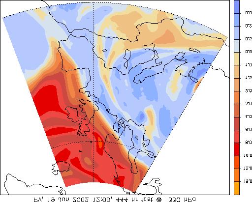
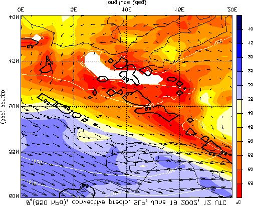
3 ECMWF Analysis, 19 June 2002, 1200 UTC Equivalent potential temp., 850 hpa Wind, 250 hpa Cold front across northern Germany, `Spanish plume situation with high temperatures as far north as Finland Convective precipitation in the warm sector Strong upper level jet associated with the front; anti-cyclonic circulation south of the ridge associated with small positive PV anomaly

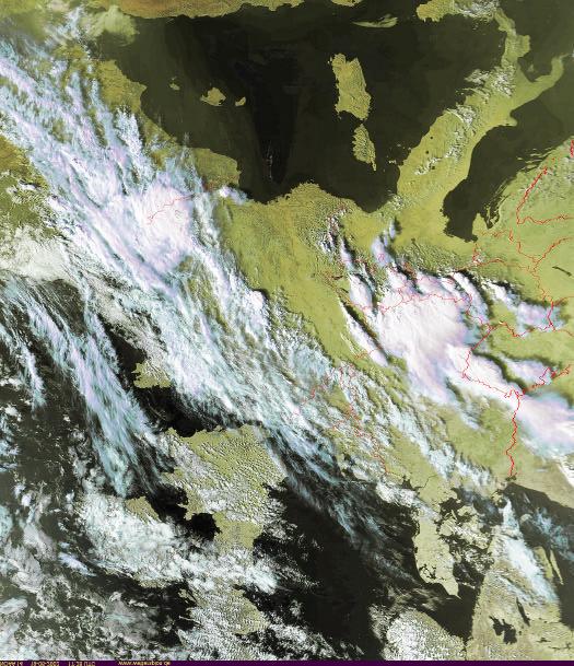
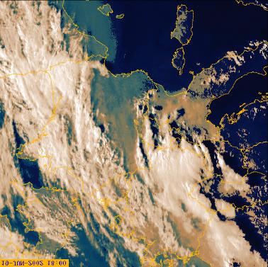
4 1430 UTC METEOSAT, 19 June 2002 `coordinated`convection across Europe 1600 UTC Provided by Harald Sodemann, ETHZ

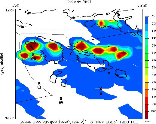
5 15 min radar-derived precipitation, 19 June 2002, UTC DWD PC product, processed by Martin Hagen, DLR


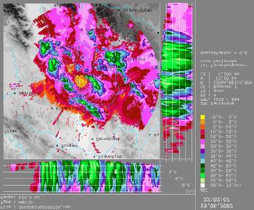
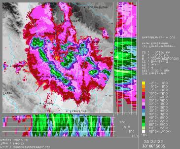
6 1500 UTC Local convection in the southern black forest region in the late afternoon (1500 UTC) and early evening (1800 UTC), more organized convection at late evening (2015 UTC) northern black forest UTC 2015 UTC DWD PC Product processed by Martin Hagen, DLR

7 Total Precipitation, 19 June 2002 Surface observations, 24 h Radar precipitation,15-24 UTC Operational LM forecast,15 24 UTC
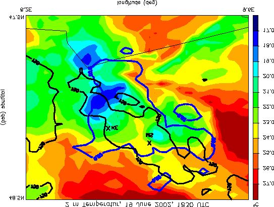
8 The LokalModell (LM) Installed at University Mainz on a Linux Cluster since September 2005, currently used in 2 projects. Special thanks for the support from DWD: Michael Baldauf, Jochen Förstner, Erdmann Heise, Christian Koziar, Thorsten Reinhard, Ulrich Schättler, Jan-Peter Schulz, Axel Seifert Here: 2.8 km resolution without parameterization of deep convection, initial and boundary conditions from hourly operational LM Analysis (7 km)

9 Model domain 231 x 265 horizontal grid boxes, 50 vertical layers
10 Several LM Simulations with varying parameter settings all simulations with V3.16 advection scheme: Bott, 2. order / Bott, 4. order Graupel / Ice microphysics scheme Timestep: 30 sec. / 10 sec. Implicit / Explicit vertical advection Start of model simulation at 06 / 07 / 08 am


11 Observed and simulated precipitation between 1500 and 2400 UTC Bott, 2nd order dt = 10 s Bott, 4th order expl. vert. adv. significant spread across the model simulations no simulation predicts precipitation in the Southwest Some simulations predict precipitation east of Swabian Alb Ice scheme no NPDK

12 Simulated and observed precipitation Surface observations Most realistic LM simulation 4th order Bott advection scheme start of the simulation at 07 UTC Timestep 30 sec Graupel scheme Implicit vertical advection

13 Simulated Precipitation UTC


14 Topography, wind, cloud water, 15 UTC North-easterly flow in the lower levels, surface winds modified by topography Maximum 2m-temperature and 2mhumidity in the Rhine valley, moisture is transported into the black forest Consistent with surface measurements 2m temperature, 15 UTC 2m specific humidity, 15 UTC

15 2m temperature, obs DWD Synop data provided by Barbara Früh 2m temperature, simulated
16 2m temperature, obs DWD Synop data provided by Barbara Früh 2m temperature, simulated

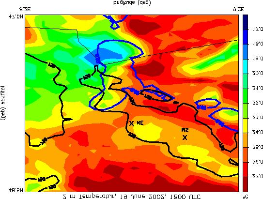
17 Observations Model results 1530 UTC 1830 UTC Temperature drop in the observations and the model simulations correlate with precipitation.
18 Simulated precipitation, 1830 UTC
19 Simulated precipitation, up-/downdrafts

20 Simulated precipitation, wind field

21 Simulated temperature, precipitation


22 Evaluation of Cloud Structures Radar precipitation, 21 UTC Simulated precipitation, 21 UTC Note: different color scales!! DWD PC Product processed by Martin Hagen, DLR

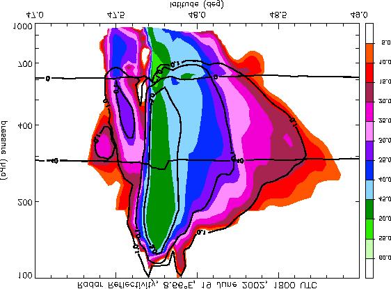
23 Karlsruhe Radar, IMK Radar reflectivity from LM Individual small scale structure are not reproduced, but simulated DBZ values are in the right order of magnitude.


24 Karlsruhe Radar, IMK Radar reflectivity from LM 14 km 12 km 9.5 km 5.8 km Evaluation of the vertical structure of convection possible The intensity of the convections seems to be overestimated
25 Conclusions: LM is running at University Mainz 1. case study: , convection in the black forest Observations: local convection in the afternoon and early evening, organized convection in the evening Model: Significant spread between different model setups no initiation of local convection, organized convection can be reproduced Processes related to convection, e.g., formation of a cold pool, are included LM provides realistic description of convective clouds
26 Outlook: Evaluate the model results with field observations (VERTIKATOR) Increase the model domain and the spatial resolution, use different initial and boundary conditions Conduct sensitivity studies: soil moisture, topography, etc. Use of more sophisticated physics packages (radiation, cloud microphysics) Evaluate other convective cases

27 Orography Plant Surface Soil type
28
29 Orography External parameters used in the LM at 2.8 km resolution. Some parameters (orography, plant surface) capture small sale structures, others (e.g., soil type) are rather coarse. Plant Surface Soil type
30
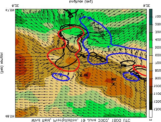
31
32
33 Evaluation of the vertical profiles
34 Evaluation of the vertical profiles Transport of cold, moist air masses from the east (black forest) between 1.5 and 2 km.
35 Evaluation of the vertical profiles
36
37 Surface Wind in LM at 7 km and 2.8 km resolution 7 km 2.8 km More realistic surface wind fields (especially in valleys) and formation of clouds. Realistic description of the processes that initiate convection!?


38 Surface Temperature and Wind Fields 2 m temperature, horizontal wind at 950 hpa, vertical wind at 850 hpa 1645 UTC 2000 UTC Wind convergence induces updrafts; cloud and precipitation formation induces downdrafts, creation of a surface cold pool: realistic description of convection dynamics


39 Hourly precipitation Radar UTC LM UTC

40 Radar Total precipitation UTC LM Model underestimates the amount of precipitation misses the early part of the convection the SW-black forest area.
41 Radar Total precipitation LM 24 hour-precipitation from rain-gauges Radar-derived precipitation significantly higher than measured by rain-gauges Heavy precipitation in the SW-black forest also present in rain-gauge data
42
43
44 2145 UTC


45 1340 UTC 1930 UTC 2000 UTC 2030 UTC
46
47
48 Tool kit: Lokal-Modell (LM) from DWD Observations routine: Satellite, Radar field campaigns: ground-stations, additional radiosondes etc.

49 The `Monster from the Rhinevalley, left-moving supercell up to 16 km taken from


50 Orographie in LM at 7 km and 2.8 km resolution 7 km 2.8 km Substantially more details of the orography at higher resolution.
51 Evaluation of the vertical profiles
CONVECTIVE CLOUD MICROPHYSICS IN A HIGH-RESOLUTION NWP MODEL
 CONVECTIVE CLOUD MICROPHYSICS IN A HIGH-RESOLUTION NWP MODEL J. Trentmann 1, A. Seifert 2, H. Wernli 1 1 Institute for Atmospheric Physics, Johannes Gutenberg University Mainz, Germany 2 German Weather
COSMO model simulations for COPS, 15 July 2007 (IOP 8b)
") COSMO model simulations for COPS, 15 July 2007 (IOP 8b) Jörg Trentmann, Björn Brötz, Heini Wernli Institute for Atmospheric Physics Johannes Gutenberg University Mainz OUTLINE The Convective and Orographically-
COSMO model simulations for COPS, 15 July 2007 (IOP 8b) Jörg Trentmann, Björn Brötz, Heini Wernli Institute for Atmospheric Physics Johannes Gutenberg University Mainz OUTLINE The Convective and Orographically-
ALARO experience in Romania
 ALARO experience in Romania S. Briceag, M. Pietrisi, S. Tascu, A. Craciun, R. Iordache National Meteorological Administration, Romania Operational model setup ALARO cy36t1: 1 January 2014 31 March 2016
Working Group Initiation of Convection
 Working Group Initiation of Convection Ulrich Corsmeier Institut für Meteorologie und Klimaforschung (IMK) Forschungszentrum Karlsruhe/Universität Karlsruhe 2 nd COPS Workshop June 27 June 28, 2005 University
CONVECTION-ALLOWING SIMULATIONS OF COLD POOLS IN THE NORTHWESTERN SAHARA
 COSMO User Seminar, Langen, 4th March 2008 CONVECTION-ALLOWING SIMULATIONS OF COLD POOLS IN THE NORTHWESTERN SAHARA 1 Peter Knippertz, 1 Jörg Trentmann & 2 Axel Seifert 1 Institute for Atmospheric Physics,
A Revised Version of the Cloud Microphysical Parameterization of COSMO-LME
 A Revised Version of the Cloud Microphysical Parameterization of COSMO-LME Axel Seifert DWD, Offenbach -1- Motivation: Well known problems of COSMO-LME regards wintertime precipitation: Overestimation
Romanian Contribution in Quantitative Precipitation Forecasts Project
 3 Working Group on Physical Aspects 29 Romanian Contribution in Quantitative Precipitation Forecasts Project Rodica Dumitrache, Victor Pescaru, Liliana Velea, Cosmin Barbu National Meteorological Administration,
Simulations of Convergence Lines
 Simulations of Convergence Lines with Convection using COSMO-DE Markus Übel and Andreas Bott (University of Bonn) --- COSMO User Seminar 2011 --- Outline Motivation Definition of convergence lines Simulation
Diabatic processes and the structure of the warm conveyor belt
 2 nd European Windstorm Workshop Leeds, 3-4 September 2012 Diabatic processes and the structure of the warm conveyor belt Oscar Martínez-Alvarado J. Chagnon, S. Gray, R. Plant, J. Methven Department of
Simulations with different convection parameterizations in the LM
 Simulations with different convection parameterizations in the LM Linda Smoydzin Almut Gassmann Andreas Bott Marco Arpagaus (Meteo Swiss) Meteorological Institute of the University of Bonn, Germany Aims
Report of the COPS WG on CI summarising COPS results presented at the ICAM 2009 in Rastatt, Germany. Compiled by Ulrich Corsmeier, IMK-KIT
 Report of the COPS WG on CI summarising COPS results presented at the ICAM 2009 in Rastatt, Germany Compiled by Ulrich Corsmeier, IMK-KIT August 2009 The scientic goals of the COPS working group on convection
COSMO / CLM Training Course
 COSMO / CLM Training Course DWD and the CLM-Community DWD Training and Conference Center (BTZ) in Langen 02-06 March 2009 Introduction The COSMO-model together with the preprocessing package is a state
SYNOPTIC AND MESOSCALE ASPECTS OF TWO FLASH FLOOD EVENTS IN EASTERN SPAIN PRODUCED BY LONG-LIVED
 SYNOPTIC AND MESOSCALE ASPECTS OF TWO FLASH FLOOD EVENTS IN EASTERN SPAIN PRODUCED BY LONG-LIVED LIVED QUASISTATIONARY MCSs: ROLE OF ATLAS MOUNTAINS AND LATENT HEAT RELEASE R. Romero C. A. Doswell III
CHAPTER 8 NUMERICAL SIMULATIONS OF THE ITCZ OVER THE INDIAN OCEAN AND INDONESIA DURING A NORMAL YEAR AND DURING AN ENSO YEAR
 CHAPTER 8 NUMERICAL SIMULATIONS OF THE ITCZ OVER THE INDIAN OCEAN AND INDONESIA DURING A NORMAL YEAR AND DURING AN ENSO YEAR In this chapter, comparisons between the model-produced and analyzed streamlines,
A hierarchy of one- and two-moment microphysical parameterizations in the COSMO model
 Deutscher Wetterdienst GB Forschung und Entwicklung A hierarchy of one- and two-moment microphysical parameterizations in the COSMO model Axel Seifert German Weather Service Offenbach, Germany Ulrich Blahak
1 INTRODUCTION 2 MODEL SETUP
 8.1 INFLUENCE OF AMBIENT ENVIRONMENTAL CONDITIONS AND OROGRAPHY ON THE CHARACTERISTICS OF DEEP CONVECTIVE CELLS AS SIMULATED WITH A SOPHISTICATED TWO-MOMENT (BULK) MICROPHYSICAL SCHEME Ulrich Blahak, H.
Microphysical heating rates and PV modification in a warm conveyor belt: Comparison of a COSMO and IFS simulation
 Microphysical heating rates and PV modification in a warm conveyor belt: Comparison of a COSMO and IFS simulation Montreal, August 18th 2014 H. Joos1, M. Böttcher1, R. Forbes2 and H. Wernli1 1) IAC, ETH
Diabatic processes and the structure of extratropical cyclones
 Geophysical and Nonlinear Fluid Dynamics Seminar AOPP, Oxford, 23 October 2012 Diabatic processes and the structure of extratropical cyclones Oscar Martínez-Alvarado R. Plant, J. Chagnon, S. Gray, J. Methven
Experiments with Idealized Supercell Simulations
 Latent Heat Nudging in almo: Experiments with Idealized Supercell Simulations Daniel Leuenberger and Andrea Rossa MeteoSwiss Talk Outline Introduction Supercell Storms Characteristics Reference simulation
Simulating orographic precipitation: Sensitivity to physics parameterizations and model numerics
 Simulating orographic precipitation: Sensitivity to physics parameterizations and model numerics 2nd COPS-Meeting, 27 June 2005 Günther Zängl Overview A highly idealized test of numerical model errors
Air Mass Thunderstorms. Air Mass Thunderstorms. Air Mass Thunderstorms. Lecture 26 Air Mass Thunderstorms and Lightning
 Lecture 26 and Lightning Life Cycle Environment Climatology Lightning 1 2 Short-lived, isolated thunderstorms that are not severe are often called air-mass thunderstorms. There are three stages describing
Detailed flow, hydrometeor and lightning characteristics of an isolated, hail producing thunderstorm during COPS
 Detailed flow, hydrometeor and lightning characteristics of an isolated, hail producing thunderstorm during COPS, Martin Hagen, Hartmut Höller, Hans Volkert Institut für Physik der Atmosphäre, DLR Oberpfaffenhofen
Assimilation of radar reflectivity
 Assimilation of radar reflectivity Axel Seifert Deutscher Wetterdienst, Offenbach, Germany Convective-scale NWP at DWD: Plans for 2020 Storm-scale ICON-RUC-EPS: hourly 12h ensemble forecasts based on short
2.39 A NEW METHOD FOR THE NOWCASTING OF STRATIFORM PRECIPITATION USING RADAR DATA AND THE HORIZONTAL WIND FIELD OF THE GERMAN LOKALMODELL (LM).
.") 2.39 A NEW METHOD FOR THE NOWCASTING OF STRATIFORM PRECIPITATION USING RADAR DATA AND THE HORIZONTAL WIND FIELD OF THE GERMAN LOKALMODELL (LM). Tanja Winterrath * Deutscher Wetterdienst, Offenbach am Main,
2.39 A NEW METHOD FOR THE NOWCASTING OF STRATIFORM PRECIPITATION USING RADAR DATA AND THE HORIZONTAL WIND FIELD OF THE GERMAN LOKALMODELL (LM). Tanja Winterrath * Deutscher Wetterdienst, Offenbach am Main,
Preliminary results with very high resolution COSMO model for the forecast of convective events. Antonella Morgillo. Arpa-Simc.
 2 Working Group on Physical Aspects 52 Preliminary results with very high resolution COSMO model for the forecast of convective events. Antonella Morgillo Arpa-Simc amorgillo@arpa.emr.it 1 Introduction
Extratropical and Polar Cloud Systems
 Extratropical and Polar Cloud Systems Gunilla Svensson Department of Meteorology & Bolin Centre for Climate Research George Tselioudis Extratropical and Polar Cloud Systems Lecture 1 Extratropical cyclones
WRF Model Simulated Proxy Datasets Used for GOES-R Research Activities
 WRF Model Simulated Proxy Datasets Used for GOES-R Research Activities Jason Otkin Cooperative Institute for Meteorological Satellite Studies Space Science and Engineering Center University of Wisconsin
Status-quo of COPS Scientific Preparation, Candidate Instrumentation, Workshop Overview
 Status-quo of COPS Scientific Preparation, Candidate Instrumentation, Workshop Overview Andreas Behrendt, Volker Wulfmeyer Institut für Physik und Meteorologie (IPM), Universität Hohenheim, Stuttgart Christoph
Severe Weather with a strong cold front: 2-3 April 2006 By Richard H. Grumm National Weather Service Office State College, PA 16803
 Severe Weather with a strong cold front: 2-3 April 2006 By Richard H. Grumm National Weather Service Office State College, PA 16803 1. INTRODUCTION A strong cold front brought severe weather to much of
Cloud parameterization and cloud prediction scheme in Eta numerical weather model
 Cloud parameterization and cloud prediction scheme in Eta numerical weather model Belgrade, 10th September, 2018 Ivan Ristić, CEO at Weather2 Ivana Kordić, meteorologist at Weather2 Introduction Models
Description of the ET of Super Typhoon Choi-Wan (2009) based on the YOTC-dataset
 based on the YOTC-dataset") High Impact Weather PANDOWAE Description of the ET of Super Typhoon Choi-Wan (2009) based on the YOTC-dataset ¹, D. Anwender¹, S. C. Jones2, J. Keller2, L. Scheck¹ 2 ¹Karlsruhe Institute of Technology,
High Impact Weather PANDOWAE Description of the ET of Super Typhoon Choi-Wan (2009) based on the YOTC-dataset ¹, D. Anwender¹, S. C. Jones2, J. Keller2, L. Scheck¹ 2 ¹Karlsruhe Institute of Technology,
Idealized Nonhydrostatic Supercell Simulations in the Global MPAS
 Idealized Nonhydrostatic Supercell Simulations in the Global Joe Klemp, Bill Skamarock, and Sang-Hun Park National Center for Atmospheric Research Boulder, Colorado Typical characteristics: Supercell Thunderstorms
Mesoscale meteorological models. Claire L. Vincent, Caroline Draxl and Joakim R. Nielsen
 Mesoscale meteorological models Claire L. Vincent, Caroline Draxl and Joakim R. Nielsen Outline Mesoscale and synoptic scale meteorology Meteorological models Dynamics Parametrizations and interactions
ICON. Limited-area mode (ICON-LAM) and updated verification results. Günther Zängl, on behalf of the ICON development team
 and updated verification results. Günther Zängl, on behalf of the ICON development team") ICON Limited-area mode (ICON-LAM) and updated verification results Günther Zängl, on behalf of the ICON development team COSMO General Meeting, Offenbach, 07.09.2016 Outline Status of limited-area-mode
ICON Limited-area mode (ICON-LAM) and updated verification results Günther Zängl, on behalf of the ICON development team COSMO General Meeting, Offenbach, 07.09.2016 Outline Status of limited-area-mode
ALADIN forecast experience in Croatia
 ALADIN forecast experience in Croatia Lidija Fustar and Tomislav Kozaric Meteorological and Hydrological Service ALADIN at DHMZ main source for the operational forecast at National Service of Croatia (along
Di Wu, Xiquan Dong, Baike Xi, Zhe Feng, Aaron Kennedy, and Gretchen Mullendore. University of North Dakota
 Di Wu, Xiquan Dong, Baike Xi, Zhe Feng, Aaron Kennedy, and Gretchen Mullendore University of North Dakota Objectives 3 case studies to evaluate WRF and NAM performance in Oklahoma (OK) during summer 2007,
 This article was originally published in a journal published by Elsevier, and the attached copy is provided by Elsevier for the author s benefit and for the benefit of the author s institution, for non-commercial
Implementation and Evaluation of WSR-88D Reflectivity Data Assimilation for WRF-ARW via GSI and Cloud Analysis. Ming Hu University of Oklahoma
 Implementation and Evaluation of WSR-88D Reflectivity Data Assimilation for WRF-ARW via GSI and Cloud Analysis Ming Hu University of Oklahoma 1. Previous work and Goal of visiting Previous work: Radar
Preliminary results. Leonardo Calvetti, Rafael Toshio, Flávio Deppe and Cesar Beneti. Technological Institute SIMEPAR, Curitiba, Paraná, Brazil
 HIGH RESOLUTION WRF SIMULATIONS FOR WIND GUST EVENTS Preliminary results Leonardo Calvetti, Rafael Toshio, Flávio Deppe and Cesar Beneti Technological Institute SIMEPAR, Curitiba, Paraná, Brazil 3 rd WMO/WWRP
Developments at DWD: Integrated water vapour (IWV) from ground-based GPS
 from ground-based GPS") 1 Working Group on Data Assimilation 2 Developments at DWD: Integrated water vapour (IWV) from ground-based Christoph Schraff, Maria Tomassini, and Klaus Stephan Deutscher Wetterdienst, Frankfurter Strasse
1 Working Group on Data Assimilation 2 Developments at DWD: Integrated water vapour (IWV) from ground-based Christoph Schraff, Maria Tomassini, and Klaus Stephan Deutscher Wetterdienst, Frankfurter Strasse
INVESTIGATION FOR A POSSIBLE INFLUENCE OF IOANNINA AND METSOVO LAKES (EPIRUS, NW GREECE), ON PRECIPITATION, DURING THE WARM PERIOD OF THE YEAR
, ON PRECIPITATION, DURING THE WARM PERIOD OF THE YEAR") Proceedings of the 13 th International Conference of Environmental Science and Technology Athens, Greece, 5-7 September 2013 INVESTIGATION FOR A POSSIBLE INFLUENCE OF IOANNINA AND METSOVO LAKES (EPIRUS,
Proceedings of the 13 th International Conference of Environmental Science and Technology Athens, Greece, 5-7 September 2013 INVESTIGATION FOR A POSSIBLE INFLUENCE OF IOANNINA AND METSOVO LAKES (EPIRUS,
Mass Conserving Courant Number Independent Eulerian Advection of the Moisture Quantities for the LMK
 Mass Conserving Courant Number Independent Eulerian Advection of the Moisture Quantities for the LMK Jochen Förstner, Michael Baldauf, Axel Seifert Deutscher Wetterdienst, Kaiserleistraße 29/35, 63067
What does a cloud-resolving model bring during an extratropical transition?
 What does a cloud-resolving model bring during an extratropical transition? Florian Pantillon (1) Jean-Pierre Chaboureau (1) Christine Lac (2) Patrick Mascart (1) (1) Laboratoire d'aérologie, Toulouse,
Myung-Sook Park, Russell L. Elsberry and Michael M. Bell. Department of Meteorology, Naval Postgraduate School, Monterey, California, USA
 Latent heating rate profiles at different tropical cyclone stages during 2008 Tropical Cyclone Structure experiment: Comparison of ELDORA and TRMM PR retrievals Myung-Sook Park, Russell L. Elsberry and
3D-Transport of Precipitation
 3D-Transport of Precipitation Almut Gassmann DWD/FE 13 October 17, 2000 1 Current diagnostic scheme for gridscale precipitation The current scheme for gridscale precipitation assumes column equilibrium
Chapter 3 Convective Dynamics 3.4. Bright Bands, Bow Echoes and Mesoscale Convective Complexes
 Chapter 3 Convective Dynamics 3.4. Bright Bands, Bow Echoes and Mesoscale Convective Complexes Photographs Todd Lindley Bright band associated with stratiform precipitation in a squall line system 1 Bright
The convection-permitting COSMO-DE-EPS and PEPS at DWD
 Deutscher Wetterdienst The convection-permitting COSMO-DE-EPS and PEPS at DWD Detlev Majewski based on Chr. Gebhardt, S. Theis, M. Paulat, M. Buchhold and M. Denhard Deutscher Wetterdienst The model COSMO-DE
Weather Systems III: Thunderstorms and Twisters
 Weather Systems III: Thunderstorms and Twisters Review 1. Definition of airmasses? Bergeron classification of air masses 2. Surface weather analysis: Station model, wind speed code, present weather 3.
Heavy rains and precipitable water anomalies August 2010 By Richard H. Grumm And Jason Krekeler National Weather Service State College, PA 16803
 Heavy rains and precipitable water anomalies 17-19 August 2010 By Richard H. Grumm And Jason Krekeler National Weather Service State College, PA 16803 1. INTRODUCTION Heavy rain fell over the Gulf States,
Department of Geosciences San Francisco State University Spring Metr 201 Monteverdi Quiz #5 Key (100 points)
") Department of Geosciences Name San Francisco State University Spring 2012 Metr 201 Monteverdi Quiz #5 Key (100 points) 1. Fill in the Blank or short definition. (3 points each for a total of 15 points)
Department of Geosciences Name San Francisco State University Spring 2012 Metr 201 Monteverdi Quiz #5 Key (100 points) 1. Fill in the Blank or short definition. (3 points each for a total of 15 points)
Winter Storm of 15 December 2005 By Richard H. Grumm National Weather Service Office State College, PA 16803
 Winter Storm of 15 December 2005 By Richard H. Grumm National Weather Service Office State College, PA 16803 1. INTRODUCTION A complex winter storm brought snow, sleet, and freezing rain to central Pennsylvania.
Charles A. Doswell III, Harold E. Brooks, and Robert A. Maddox
 Charles A. Doswell III, Harold E. Brooks, and Robert A. Maddox Flash floods account for the greatest number of fatalities among convective storm-related events but it still remains difficult to forecast
Kalimantan realistically (Figs. 8.23a-d). Also, the wind speeds of the westerly
. Also, the wind speeds of the westerly") suppressed rainfall rate (maximum vertical velocity) around 17 LST (Figs. 8.21a-b). These results are in agreement with previous studies (e. g., Emanuel and Raymond 1994). The diurnal variation of maximum
suppressed rainfall rate (maximum vertical velocity) around 17 LST (Figs. 8.21a-b). These results are in agreement with previous studies (e. g., Emanuel and Raymond 1994). The diurnal variation of maximum
Impact of different cumulus parameterizations on the numerical simulation of rain over southern China
 Impact of different cumulus parameterizations on the numerical simulation of rain over southern China P.W. Chan * Hong Kong Observatory, Hong Kong, China 1. INTRODUCTION Convective rain occurs over southern
Diagnosis of the meteorological situation of August 16 th 2003: an extreme hail event p. 1/1
 Diagnosis of the meteorological situation of August 16 th 2003: an extreme hail event ECSS 2004 E. García-Ortega a, L. Fita b, R. Romero b, L. López a, C. Ramis b and J. L. Sánchez a a Laboratorio de Física
MSG FOR NOWCASTING - EXPERIENCES OVER SOUTHERN AFRICA
 MSG FOR NOWCASTING - EXPERIENCES OVER SOUTHERN AFRICA Estelle de Coning and Marianne König South African Weather Service, Private Bag X097, Pretoria 0001, South Africa EUMETSAT, Am Kavalleriesand 31, D-64295
WG 3a activities in radiation and microphysics Ulrich Blahak (DWD)
") WG 3a actiities in radiation and microphysics Ulrich Blahak (DWD) COSMO General Meeting, Wroclaw, 7.-10.9.2015 1 Radiation actiities PT RC 2, reised cloud radiation coupling (see extra presentation): Porting
WG 3a actiities in radiation and microphysics Ulrich Blahak (DWD) COSMO General Meeting, Wroclaw, 7.-10.9.2015 1 Radiation actiities PT RC 2, reised cloud radiation coupling (see extra presentation): Porting
Precipitation Structure and Processes of Typhoon Nari (2001): A Modeling Propsective
: A Modeling Propsective") Precipitation Structure and Processes of Typhoon Nari (2001): A Modeling Propsective Ming-Jen Yang Institute of Hydrological Sciences, National Central University 1. Introduction Typhoon Nari (2001) struck
Precipitation Structure and Processes of Typhoon Nari (2001): A Modeling Propsective Ming-Jen Yang Institute of Hydrological Sciences, National Central University 1. Introduction Typhoon Nari (2001) struck
THE SYNOPTIC ENVIRONMENT OF THE 11 APRIL 2001 CENTRAL PLAINS TORNADO OUTBREAK VIEWED IN THREE DIMENSIONS
 P1.1 THE SYNOPTIC ENVIRONMENT OF THE 11 APRIL 2001 CENTRAL PLAINS TORNADO OUTBREAK VIEWED IN THREE DIMENSIONS Daniel D. Nietfeld * NOAA/NWS/WFO Omaha/Valley, NE 1. INTRODUCTION A powerful low pressure
The Impacts of GPSRO Data Assimilation and Four Ices Microphysics Scheme on Simulation of heavy rainfall Events over Taiwan during June 2012
 The Impacts of GPSRO Data Assimilation and Four Ices Microphysics Scheme on Simulation of heavy rainfall Events over Taiwan during 10-12 June 2012 Pay-Liam LIN, Y.-J. Chen, B.-Y. Lu, C.-K. WANG, C.-S.
Forecast for 6/28-7/31. Forecaster: Matthew Brewer Forecast made at: 12z 6/27/2017
 Forecast for 6/28-7/31 Forecaster: Matthew Brewer Forecast made at: 12z 6/27/2017 Whiteface lodge Mesonet Meteogram for the past 24 hours http://www.nysmesonet.org/data/meteogram#?stid=wfmb Whiteface Summit
Working Group 5: Verification and Case Studies Overview
 Working Group 5: Verification and Case Studies Overview COSMO General Meeting 21-24.09.2004 Francis Schubiger, MeteoSwiss Working Packages Verification verification of surface weather parameters verification
Heavy Rainfall Event of June 2013
 Heavy Rainfall Event of 10-11 June 2013 By Richard H. Grumm National Weather Service State College, PA 1. Overview A 500 hpa short-wave moved over the eastern United States (Fig. 1) brought a surge of
Florian Meier, Peter Knippertz Johannes Gutenberg-University Mainz
 Sensitivity experiments with the COSMO-Model - the influence of upstream latent heating and wave amplification on a heavy precipitation event over West Africa Florian Meier, Peter Knippertz Johannes Gutenberg-University
Hydrologic Research Laboratory Department of Civil and Environmental Engineering University of California, Davis
 Physically-Based Estimation of Maximum Precipitation: Preliminary Results on Application to American River Basin for the December,1996-January,1997 Flood Event Hydrologic Research Laboratory Department
Large-Eddy Simulations of Tropical Convective Systems, the Boundary Layer, and Upper Ocean Coupling
 DISTRIBUTION STATEMENT A. Approved for public release; distribution is unlimited. Large-Eddy Simulations of Tropical Convective Systems, the Boundary Layer, and Upper Ocean Coupling Eric D. Skyllingstad
ATS 351, Spring 2010 Lab #11 Severe Weather 54 points
 ATS 351, Spring 2010 Lab #11 Severe Weather 54 points Question 1 (10 points): Thunderstorm development a) Sketch and describe the stages of development of a single cell thunderstorm. About how long does
Comparison of cloud statistics from Meteosat with regional climate model data
 Comparison of cloud statistics from Meteosat with regional climate model data R. Huckle, F. Olesen, G. Schädler Institut für Meteorologie und Klimaforschung, Forschungszentrum Karlsruhe, Germany (roger.huckle@imk.fzk.de
Heavy Rainfall and Flooding of 23 July 2009 By Richard H. Grumm And Ron Holmes National Weather Service Office State College, PA 16803
 Heavy Rainfall and Flooding of 23 July 2009 By Richard H. Grumm And Ron Holmes National Weather Service Office State College, PA 16803 1. INTRODUCTION Heavy rains fall over Pennsylvania and eastern New
Multi-day severe event of May 2013
 Abstract: Multi-day severe event of 18-22 May 2013 By Richard H. Grumm and Charles Ross National Weather Service State College, PA A relatively slow moving Trough over the western United States and a ridge
Representing deep convective organization in a high resolution NWP LAM model using cellular automata
 Representing deep convective organization in a high resolution NWP LAM model using cellular automata Lisa Bengtsson-Sedlar SMHI ECMWF, WMO/WGNE, WMO/THORPEX and WCRP WS on Representing model uncertainty
9D.3 THE INFLUENCE OF VERTICAL WIND SHEAR ON DEEP CONVECTION IN THE TROPICS
 9D.3 THE INFLUENCE OF VERTICAL WIND SHEAR ON DEEP CONVECTION IN THE TROPICS Ulrike Wissmeier, Robert Goler University of Munich, Germany 1 Introduction One does not associate severe storms with the tropics
Convective Structures in Clear-Air Echoes seen by a Weather Radar
 Convective Structures in Clear-Air Echoes seen by a Weather Radar Martin Hagen Deutsches Zentrum für Luft- und Raumfahrt Oberpfaffenhofen, Germany Weather Radar Weather radar are normally used to locate
Module 11: Meteorology Topic 5 Content: Weather Maps Notes
 Introduction A variety of weather maps are produced by the National Weather Service and National Oceanographic Atmospheric Administration. These maps are used to help meteorologists accurately predict
The Regional Atmospheric Water Budget over Southwestern Germany under Different Synoptic Conditions
 FEBRUARY 2013 S A S S E E T A L. 69 The Regional Atmospheric Water Budget over Southwestern Germany under Different Synoptic Conditions ROMI SASSE, GERD SCHÄDLER, AND CHRISTOPH KOTTMEIER Institute of Meteorology
P4.9 THE SEVERE THUNDERSTORM OUTBREAK IN FINLAND ON 5 JULY 2002
 P4.9 THE SEVERE THUNDERSTORM OUTBREAK IN FINLAND ON 5 JULY 2002 Ari-Juhani Punkka* and Jenni Teittinen Finnish Meteorological Institute, Helsinki, Finland 1. INTRODUCTION On 5 July 2002 a fast propagating
Thanksgiving Snow and Arctic Front 25 November 2005 By Richard H. Grumm National Weather Service State College, PA 16801
 Thanksgiving Snow and Arctic Front 25 November 2005 By Richard H. Grumm National Weather Service State College, PA 16801 1. INTRODUCTION An approaching arctic front brought light snow to most of western
THE MESOSCALE CONVECTIVE SYSTEM FROM
 RISCURI I CATASTROFE, NR.X, VOL.9, NR. 1/2011 THE MESOSCALE CONVECTIVE SYSTEM FROM 24.07.2010 ELZA HAUER, 1 C. NICHITA 1 ABSTRACT. The Mesoscale Convective System from 24.07.2010. A severe weather event
PV Generation in the Boundary Layer
 1 PV Generation in the Boundary Layer Robert Plant 18th February 2003 (With thanks to S. Belcher) 2 Introduction How does the boundary layer modify the behaviour of weather systems? Often regarded as a
The prognostic deep convection parametrization for operational forecast in horizontal resolutions of 8, 4 and 2 km
 The prognostic deep convection parametrization for operational forecast in horizontal resolutions of 8, 4 and 2 km Martina Tudor, Stjepan Ivatek-Šahdan and Antonio Stanešić tudor@cirus.dhz.hr Croatian
Forecasting Local Weather
 Forecasting Local Weather Sea/Land Breeze Temperature Dew Fog Frost Snow Thunderstorms Tropical Cyclones Temperatures: Radiation Balance Typical Diurnal Variation of Temperature Min soon after dawn Temp
Seoul National University. Ji-Hyun Ha, Gyu-Ho Lim and Dong-Kyou Lee
 Numerical simulation with radar data assimilation over the Korean Peninsula Seoul National University Ji-Hyun Ha, Gyu-Ho Lim and Dong-Kyou Lee Introduction The forecast skill associated with warm season
Cb-LIKE: thunderstorm forecasts up to 6 hrs with fuzzy logic
 Cb-LIKE: thunderstorm forecasts up to 6 hrs with fuzzy logic Martin Köhler DLR Oberpfaffenhofen 15th EMS/12th ECAM 07 11 September, Sofia, Bulgaria Long-term forecasts of thunderstorms why? -> Thunderstorms
Weather report 28 November 2017 Campinas/SP
 Weather report 28 November 2017 Campinas/SP Summary: 1) Synoptic analysis and pre-convective environment 2) Verification 1) Synoptic analysis and pre-convective environment: At 1200 UTC 28 November 2017
MET 3502 Synoptic Meteorology. Lecture 8: September 16, AIRMASSES, FRONTS and FRONTAL ANALYSIS (2)
") MET 3502 Synoptic Meteorology Lecture 8: September 16, 2010 AIRMASSES, FRONTS and FRONTAL ANALYSIS (2) Identifying a cold front on a surface weather map: 1. Surface front is located at the leading edge
MET 3502 Synoptic Meteorology Lecture 8: September 16, 2010 AIRMASSES, FRONTS and FRONTAL ANALYSIS (2) Identifying a cold front on a surface weather map: 1. Surface front is located at the leading edge
Extratropical processes and forecast errors
 Extratropical processes and forecast errors Heini Wernli With contributions from: Andreas Dörnbrack, Sarah Jones, George Craig Maxi Böttcher, Hanna Joos, Andreas Schäfler, Matthias Zimmer, Florian Meier,
TC/PR/RB Lecture 3 - Simulation of Random Model Errors
 TC/PR/RB Lecture 3 - Simulation of Random Model Errors Roberto Buizza (buizza@ecmwf.int) European Centre for Medium-Range Weather Forecasts http://www.ecmwf.int Roberto Buizza (buizza@ecmwf.int) 1 ECMWF
WRF MODEL STUDY OF TROPICAL INERTIA GRAVITY WAVES WITH COMPARISONS TO OBSERVATIONS. Stephanie Evan, Joan Alexander and Jimy Dudhia.
 WRF MODEL STUDY OF TROPICAL INERTIA GRAVITY WAVES WITH COMPARISONS TO OBSERVATIONS. Stephanie Evan, Joan Alexander and Jimy Dudhia. Background Small-scale Gravity wave Inertia Gravity wave Mixed RossbyGravity
PRECONVECTIVE SOUNDING ANALYSIS USING IASI AND MSG- SEVIRI
 PRECONVECTIVE SOUNDING ANALYSIS USING IASI AND MSG- SEVIRI Marianne König, Dieter Klaes EUMETSAT, Eumetsat-Allee 1, 64295 Darmstadt, Germany Abstract EUMETSAT operationally generates the Global Instability
Mesoscale Atmospheric Systems
 Mesoscale Atmospheric Systems Introduction Spring Semester 2018 Heini Wernli Outline of lecture course See also www.iac.ethz.ch/edu/courses/master/modules/mesoscale-atmospheric-systems.html 20 Feb Introduction
JP1.15 PHYSICAL INITIALIZATION TO INCORPORATE RADAR PRECIPITATION DATA INTO A NUMERICAL WEATHER PREDICTION MODEL (Lokal Model)
") JP1.15 PHYSICAL INITIALIZATION TO INCORPORATE RADAR PRECIPITATION DATA INTO A NUMERICAL WEATHER PREDICTION MODEL (Lokal Model) M. Milan 1, F. Ament 1, V. Venema 1, A. Battaglia 1, C. Simmer 1 1 Meteorological
JP1.15 PHYSICAL INITIALIZATION TO INCORPORATE RADAR PRECIPITATION DATA INTO A NUMERICAL WEATHER PREDICTION MODEL (Lokal Model) M. Milan 1, F. Ament 1, V. Venema 1, A. Battaglia 1, C. Simmer 1 1 Meteorological
DEPARTMENT OF GEOSCIENCES SAN FRANCISCO STATE UNIVERSITY. Metr Fall 2012 Test #1 200 pts. Part I. Surface Chart Interpretation.
 DEPARTMENT OF GEOSCIENCES SAN FRANCISCO STATE UNIVERSITY NAME Metr 356.01 Fall 2012 Test #1 200 pts Part I. Surface Chart Interpretation. Figure 1. Surface Chart for 1500Z 7 September 2007 1 1. Pressure
Mid-Latitude Cyclones and Fronts. Lecture 12 AOS 101
 Mid-Latitude Cyclones and Fronts Lecture 12 AOS 101 Homework 4 COLDEST TEMPS GEOSTROPHIC BALANCE Homework 4 FASTEST WINDS L Consider an air parcel rising through the atmosphere The parcel expands as it
Northeastern United States Snowstorm of 9 February 2017
 Northeastern United States Snowstorm of 9 February 2017 By Richard H. Grumm and Charles Ross National Weather Service State College, PA 1. Overview A strong shortwave produced a stripe of precipitation
Journal of Arid Meteorology
 32 3 2014 6 干旱气象 Journal of Arid Meteorology Vol. 32 No. 3 June 2014. 2012 7 27 J. 2014 32 3424-430 LIU Yong GUO Damei HU Qiyuan. Cause Analysis of an Extremely Heavy Rainstorm in Jiaxian County in the
NUMERICAL EXPERIMENTS USING CLOUD MOTION WINDS AT ECMWF GRAEME KELLY. ECMWF, Shinfield Park, Reading ABSTRACT
 NUMERICAL EXPERIMENTS USING CLOUD MOTION WINDS AT ECMWF GRAEME KELLY ECMWF, Shinfield Park, Reading ABSTRACT Recent monitoring of cloud motion winds (SATOBs) at ECMWF has shown an improvement in quality.
Verification of different wind gust parametrizations Overview of verification results at MeteoSwiss in the year 2012
 Federal Department of Home Affairs FDHA Federal Office of Meteorology and Climatology MeteoSwiss Verification of different wind gust parametrizations Overview of verification results at MeteoSwiss in the
Significant cyclone activity occurs in the Mediterranean
 TRMM and Lightning Observations of a Low-Pressure System over the Eastern Mediterranean BY K. LAGOUVARDOS AND V. KOTRONI Significant cyclone activity occurs in the Mediterranean area, mainly during the
Mid Atlantic Severe Event of 1 May 2017 Central Pennsylvania QLCS event By Richard H. Grumm National Weather Service, State College, PA 16803
 1. Overview Mid Atlantic Severe Event of 1 May 2017 Central Pennsylvania QLCS event By Richard H. Grumm National Weather Service, State College, PA 16803 A strong upper-level wave (Fig.1) moving into a
Indiana County Flash Flood of 22 June 2017
 Indiana County Flash Flood of 22 June 2017 By Richard H. Grumm National Weather Service State College, PA 1. Overview Slow moving thunderstorms brought 3 to 4 inches of rainfall to Indiana County, PA during