Michael L. Jurewicz, Sr. NOAA/NWS, Binghamton, NY WFO GYX Spring Workshop May 7, 2012
|
|
|
- Belinda Campbell
- 5 years ago
- Views:
Transcription

1 Michael L. Jurewicz, Sr. NOAA/NWS, Binghamton, NY WFO GYX Spring Workshop May 7, 2012
2 Motivation / Statistics Specific Topics A Sampling of Past and Present WFO BGM Research on Flooding Three Strikes and You re Out Flash Flood Potential Index (FFPI) Maximum Potential PWAT

3 Motivation
4
5
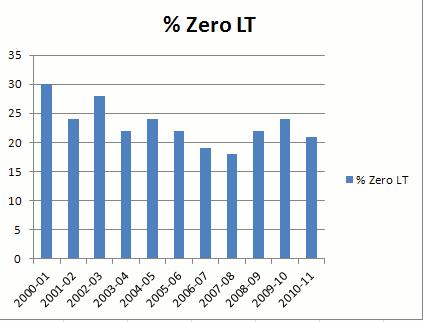
6 Although overall trends in LT have been good through the last 10 years: Zero LT Warnings are still running 15-25% About 1 out of every 5 FFW s Simply in reactive mode POD has remained about steady, however: FAR s have steadily increased As a result, CSI s have lowered over time What to do?
7 WFO BGM Three Burst Study (a.k.a Three Strikes and You re Out )

8 An established tool of the trade for warning operations is comparing Gridded FFG to accumulated / radar estimated rainfall Other tools / strategies to help us better differentiate?
9 Previous research by Davis (2000) and Kelsch (2001) Frequency of short-duration bursts vs. FFG / cumulative rainfall ratios Main suggestion: Monitoring instantaneous rate trends may be at least as important as using FFG (especially in fast responding watersheds)
10 Selected 10 major flash flood events from NY / PA since 2002 Combined costs: 11 fatalities At least hundreds of millions of dollars in damages Other numbers: Warm season cases (8): Averaged 6-7 rainfall / 3 hours Maximum: 10+ on 6/19/07 (Colchester, NY) Cool season cases (2): Averaged 2-3 rainfall / 2 hours
 Unavailable for one of the cases")
11 For our selected list of events, we evaluated the following data: KBGM WSR 88-D 0.5 Degree Base / Composite reflectivity 1-hour, 3-hour, and storm total rainfall Calculated 1-hour instantaneous rates 1-hour and 3-hour FFG (MARFC) Unavailable for one of the cases Graphically compared the following Instantaneous rates over time Ratios of accumulated rainfall to FFG


12 Rainfall rates tracked every volume scan, basin by basin Instantaneous hourly rates, accumulated rainfall, and FFG can all be displayed graphically Threat Basin Table Basin Trend Graphs
13 In the majority of cases (8 / 10), initial reports of major flooding coincided with the third burst of high intensity rainfall Specific rainfall rates were relative (air mass / season dependent)
14 Colchester: Rate vs. Time January 2010 (Broome/Susq 4.5 FF): Rate vs. Time Rates 1 Rate z 2057z 2118z 2138z 2207z 2228z 2249z 2309z 2338z 0001z 0022z 1116z 1144z 1212z 1240z 1308z 1336z 1404z 1432z 1500z 1528z 1556z 1624z 1652z June 19, 2007 January 25, 2010
15 Colchester: Rate vs. Time January 2010 (Broome/Susq Opportunity for more LT? FF): Rate vs. Time Opportunity for more LT? Rates Rate z 2057z 2118z 2138z 2207z 2228z 2249z 2309z 2338z 0001z 0022z 1116z 1144z 1212z 1240z 1308z 1336z 1404z 1432z 1500z 1528z 1556z 1624z 1652z June 19, 2007 January 25, 2010
16 At times when major flooding was reported / observed, mean accumulated rainfall to FFG ratios were: Warm season 1-hour: 1.45; 3-hour: 1.95 Significant flooding normally occurred well after FFG values were exceeded Cool season 1-hour: 0.75; 3-hour: 0.9 Significant flooding occurred prior to FFG values being reached Impervious / frozen surface?
17 Broome FF: Rate vs. Time Major Flooding Major Flooding Rate Rainfall first reaches FFG values 1 Hr FFG 3 Hr FFG z 2224z 2248z 2312z 2336z 0000z 0024z 0048z 0112z 0136z 0200z 0224z 0248z 22z, 13 June 03z, 14 June 2003 (Rate vs. Time) z 2228z 2256z 2324z 2352z 0020z 0048z 0116z 0144z 0212z 0240z 22z, 13 June 03z, 14 June 2003 (Rainfall / FFG Ratio vs. Time)
18 January 2010 (Broome/Susq FF): Rate vs. Time Major Flooding Major Flooding Rate Rainfall not yet at FFG values 1 Hr FFG 3 Hr FFG z 1144z 1212z 1240z 1308z 1336z 1404z 1432z 1500z 1528z 1556z 1624z 1652z 11z 17z, 25 January 2010 (Rate vs. Time) 1100z 1132z 1204z 1236z 1308z 1340z 1412z 1444z 1516z 1548z 1620z 1652z 11z 17z, 25 January 2010 (Rainfall / FFG Ratio vs. Time)
19 Timing bursts of high intensity rainfall show promise as a flash flood predictor At least for higher-end events Opportunities to combine this kind of diagnosis with analyses of FFG Sooner recognition of major flooding / better LT? Rainfall amounts tend to rocket past FFG values for significant warm season flash floods Possible assistance in warning decision making Lower FAR s / better CSI s? However, the BGM CWA features fairly homogenous soil types / similar land uses most areas No accounting was made for antecedent conditions
20 FFPI
21 Index is a mathematical average of geophysical characteristics of a basin Slope Land Use/Land Cover Soil Type Forest Density Index gradient is from 1 (Low) to 10 (High) Basin s potential to respond to heavy rain events leading to flash flooding. Antecedent conditions not accounted for


22 Four geographic data sets were utilized. Slope derived from the USGS DEM MLRC Land Use/Land Cover Grid AVHRR Forest Density Grid STATSGO Soil Type Classification

23 Note the good fit to empirical understanding developed over the years Also some new realizations, especially the low potential areas Differentiates the best of the worst basins in an area generally known for high flash flood potential
24 Resolution increased from 90 m to 30 m Readily displayable in AWIPS Further tweaks / mathematical re-indexing is ongoing Based on FF reports / case studies For further information: James.Brewster@noaa.gov (WFO BGM SSH)
25 Maximum Potential PWAT
26 Assessing flash flood potential can be especially difficult in rapidly changing situations Severe threat evolving to a flash flood threat Precipitable water (PWAT) can be a fickle parameter Values can change substantially / quickly as NWP convective schemes trigger Another way to view this field?


27 As storms develop/cps trigger, then they depart, model moisture profiles tend to modify quickly * PWAT could change significantly, hour to hour Max Potential PWAT values should be less subject to wild fluctuations in time / space Standard Profile Max Potential PWAT (saturated along WB temp (light blue trace))
28 Maximum potential PWAT (Arnott, 2008, /MaxPwat_Abstract.pdf) may provide a useful way to assess flash flood potential ahead of time, especially given the expectation of training / repeat cells May have the advantage of being a more stable value Needs an automated application to run (not yet developed) Local testing planned at WFO BGM
29 Arnott, J., 2008: Maximum Potential Precipitable Water A More Robust Moisture Variable? < 2008/MaxPwat_Abstract.pdf>. Davis, R. S., 2000: Detecting flash flood on small urban watersheds. Preprints, 15 th Conference on Hydrology, Amer. Meteor. Soc., Kelsch, M., 2001: The relationship between intense, short-duration precipitation and flash floods. Preprints, Symposium on Precipitation Extremes: Prediction, Impacts, and Responses, Amer. Meteor. Soc.,
30 The End!! Questions??
Existing NWS Flash Flood Guidance
 Introduction The Flash Flood Potential Index (FFPI) incorporates physiographic characteristics of an individual drainage basin to determine its hydrologic response. In flash flood situations, the hydrologic
Regional Flash Flood Guidance and Early Warning System
 WMO Training for Trainers Workshop on Integrated approach to flash flood and flood risk management 24-28 October 2010 Kathmandu, Nepal Regional Flash Flood Guidance and Early Warning System Dr. W. E. Grabs
DETECTION AND FORECASTING - THE CZECH EXPERIENCE
 1 STORM RAINFALL DETECTION AND FORECASTING - THE CZECH EXPERIENCE J. Danhelka * Czech Hydrometeorological Institute, Prague, Czech Republic Abstract Contribution presents the state of the art of operational
Dr. Amanda Schroeder. NWS Weather Forecast Office Fort Worth, TX. Sustainable Urban Water Workshop University of Texas-Arlington June 4-5, 2015
 Dr. Amanda Schroeder NWS Weather Forecast Office Fort Worth, TX Sustainable Urban Water Workshop University of Texas-Arlington June 4-5, 2015 Outline Communicating the message - official Flood and Flash
J4.6 UNDERSTANDING THE MESOSCALE PROCESSES OF FLASH FLOODS: IMPACTS ON PREDICTION AND RESPONSE
 J4.6 UNDERSTANDING THE MESOSCALE PROCESSES OF FLASH FLOODS: IMPACTS ON PREDICTION AND RESPONSE Matthew Kelsch Cooperative Program for Operational Meteorology, Education and Training (COMET ) University
Improving Situational Awareness of Flash Flooding in a Small Urban Catchment by Integrating Meteorological Analysis into a Geospatial Framework
 Improving Situational Awareness of Flash Flooding in a Small Urban Catchment by Integrating Meteorological Analysis into a Geospatial Framework John M. Goff 1, Lesley-Ann Dupigny-Giroux 2, John Kilbride
FFGS Advances. Initial planning meeting, Nay Pyi Taw, Myanmar February, Eylon Shamir, Ph.D,
 FFGS Advances Initial planning meeting, Nay Pyi Taw, Myanmar 26-28 February, 2018 Eylon Shamir, Ph.D, EShamir@hrcwater.org Hydrologic Research Center San Diego, California FFG System Enhancements The following
J1.2 LOCALLY MODIFYING FLASH FLOOD GUIDANCE TO IMPROVE THE DETECTION CAPABILITY OF THE FLASH FLOOD MONITORING AND PREDICTION PROGRAM
 J1.2 LOCALLY MODIFYING FLASH FLOOD GUIDANCE TO IMPROVE THE DETECTION CAPABILITY OF THE FLASH FLOOD MONITORING AND PREDICTION PROGRAM Robert S. Davis* NOAA/National Weather Service, Pittsburgh, PA 1. INTRODUCTION
A LOOK AT TROPICAL STORM GASTON FLOODING IN VIRGINIA
 J12B.4 A LOOK AT TROPICAL STORM GASTON FLOODING IN VIRGINIA John Billet* and Keith Lynch NOAA/NWS Wakefield, VA 1. INTRODUCTION Hurricane Gaston made landfall north of Charleston, SC on Sunday morning
Climate change and natural disasters, Athens, Greece October 31, 2018
 Flood early warning systems: operational approaches and challenges Climate change and natural disasters, Athens, Greece October 31, 2018 Athens, October 31, 2018 Marco Borga University of Padova, Italy
Flash Flood Guidance System On-going Enhancements
 Flash Flood Guidance System On-going Enhancements Hydrologic Research Center, USA Technical Developer SAOFFG Steering Committee Meeting 1 10-12 July 2017 Jakarta, INDONESIA Theresa M. Modrick Hansen, PhD
Charles A. Doswell III, Harold E. Brooks, and Robert A. Maddox
 Charles A. Doswell III, Harold E. Brooks, and Robert A. Maddox Flash floods account for the greatest number of fatalities among convective storm-related events but it still remains difficult to forecast
J9.3 USE OF A GIS-BASED FLASH FLOOD POTENTIAL IN THE FLASH FLOOD WARNING AND DECISION MAKING PROCESS
 J9.3 USE OF A GIS-BASED FLASH FLOOD POTENTIAL IN THE FLASH FLOOD WARNING AND DECISION MAKING PROCESS Mark Jackson* 1, Brian McInerney 1, and Greg Smith 2 1 NOAA/NWS/Weather Forecast Office, Salt Lake City,
Haiti and Dominican Republic Flash Flood Initial Planning Meeting
 Dr Rochelle Graham Climate Scientist Haiti and Dominican Republic Flash Flood Initial Planning Meeting September 7 th to 9 th, 2016 Hydrologic Research Center http://www.hrcwater.org Haiti and Dominican
Flooding in Western North Carolina: Some Spatial, Hydrologic, and Seasonal Characteristics CAUTION!! Outline. Basic Flood Facts.
 Flooding in Western North Carolina: Some Spatial, Hydrologic, and Seasonal Characteristics J. Greg Dobson CAUTION!! National Environmental Modeling and Analysis Center RENCI at UNC-Asheville Engagement
Haiti-Dominican Republic Flash Flood Guidance (HDRFFG) System: Development of System Products
 System: Development of System Products") Haiti-Dominican Republic Flash Flood Guidance (HDRFFG) System: Development of System Products Theresa M. Modrick, PhD Hydrologic Research Center HDRFFG Initial Planning Meeting 07-09 Sep 2015 Santo Domingo,
Haiti-Dominican Republic Flash Flood Guidance (HDRFFG) System: Development of System Products Theresa M. Modrick, PhD Hydrologic Research Center HDRFFG Initial Planning Meeting 07-09 Sep 2015 Santo Domingo,
Winter Storm of 15 December 2005 By Richard H. Grumm National Weather Service Office State College, PA 16803
 Winter Storm of 15 December 2005 By Richard H. Grumm National Weather Service Office State College, PA 16803 1. INTRODUCTION A complex winter storm brought snow, sleet, and freezing rain to central Pennsylvania.
AMERICAN METEOROLOGICAL SOCIETY
 AMERICAN METEOROLOGICAL SOCIETY Weather and Forecasting EARLY ONLINE RELEASE This is a preliminary PDF of the author-produced manuscript that has been peer-reviewed and accepted for publication. Since
CARFFG System Development and Theoretical Background
 CARFFG Steering Committee Meeting 15 SEPTEMBER 2015 Astana, KAZAKHSTAN CARFFG System Development and Theoretical Background Theresa M. Modrick, PhD Hydrologic Research Center Key Technical Components -
Areal Reduction Factors for the Colorado Front Range and Analysis of the September 2013 Colorado Storm
 Areal Reduction Factors for the Colorado Front Range and Analysis of the September 2013 Colorado Storm Doug Hultstrand, Bill Kappel, Geoff Muhlestein Applied Weather Associates, LLC - Monument, Colorado
Neil I. Fox*, David M. Jankowski, Elizabeth Hatter and Elizabeth Heiberg University of Missouri - Columbia, Columbia, Missouri, USA
 5.10 FORECASTING STORM DURATION Neil I. Fox*, David M. Jankowski, Elizabeth Hatter and Elizabeth Heiberg University of Missouri - Columbia, Columbia, Missouri, USA 1. INTRODUCTION The approach to severe
Global Flash Flood Guidance System Status and Outlook
 Global Flash Flood Guidance System Status and Outlook HYDROLOGIC RESEARCH CENTER San Diego, CA 92130 http://www.hrcwater.org Initial Planning Meeting on the WMO HydroSOS, Entebbe, Uganda 26-28 September
Central Asia Regional Flash Flood Guidance System 4-6 October Hydrologic Research Center A Nonprofit, Public-Benefit Corporation
 http://www.hrcwater.org Central Asia Regional Flash Flood Guidance System 4-6 October 2016 Hydrologic Research Center A Nonprofit, Public-Benefit Corporation FFGS Snow Components Snow Accumulation and
Indiana County Flash Flood of 22 June 2017
 Indiana County Flash Flood of 22 June 2017 By Richard H. Grumm National Weather Service State College, PA 1. Overview Slow moving thunderstorms brought 3 to 4 inches of rainfall to Indiana County, PA during
Severe Weather Watches, Advisories & Warnings
 Severe Weather Watches, Advisories & Warnings Tornado Watch Issued by the Storm Prediction Center when conditions are favorable for the development of severe thunderstorms and tornadoes over a larger-scale
System Validation. SEEFFG Operations Workshop. Theresa M. Modrick, PhD Hydrologic Engineer Hydrologic Research Center
 SEEFFG Operations Workshop System Validation Theresa M. Modrick, PhD Hydrologic Engineer Hydrologic Research Center TModrick@hrcwater.org 09 May 2016 1 Fundamental Concepts for Flash Flood Guidance FFG
NRC Workshop - Probabilistic Flood Hazard Assessment Jan 2013
 Regional Precipitation-Frequency Analysis And Extreme Storms Including PMP Current State of Understanding/Practice Mel Schaefer Ph.D. P.E. MGS Engineering Consultants, Inc. Olympia, WA NRC Workshop - Probabilistic
THE DEVELOPMENT OF RAIN-BASED URBAN FLOOD FORECASTING METHOD FOR RIVER MANAGEMENT PRACTICE USING X-MP RADAR OBSERVATION
 Research Paper Advances in River Engineering, JSCE, Vol.19, 2013,June THE DEVELOPMENT OF RAIN-BASED URBAN FLOOD FORECASTING METHOD FOR RIVER MANAGEMENT PRACTICE USING X-MP RADAR OBSERVATION Seongsim YOON
Surface Hydrology Research Group Università degli Studi di Cagliari
 Surface Hydrology Research Group Università degli Studi di Cagliari Evaluation of Input Uncertainty in Nested Flood Forecasts: Coupling a Multifractal Precipitation Downscaling Model and a Fully-Distributed
Lessons Learned and Shared
 Lessons Learned and Shared Plan for the worst. Hope for the best. Remember that hope is not a strategy. Agnes 8 Lessons 1. Identify Susceptible Communities 2. Develop a Plan 3. Threat Recognition 4. Review
IMPLEMENTATION OF AN ICE JAM PREDICTOR WITH USER INTERFACE
 Ice in the Environment: Proceedings of the 16th IAHR International Symposium on Ice Dunedin, New Zealand, 2nd 6th December 2002 International Association of Hydraulic Engineering and Research IMPLEMENTATION
Radar Network for Urban Flood and Severe Weather Monitoring
 Radar Network for Urban Flood and Severe Weather Monitoring V. Chandrasekar 1 and Brenda Philips 2 Colorado State University, United States University of Massachusetts, United States And the full DFW team
Results of Intensity-Duration- Frequency Analysis for Precipitation and Runoff under Changing Climate
 Results of Intensity-Duration- Frequency Analysis for Precipitation and Runoff under Changing Climate Supporting Casco Bay Region Climate Change Adaptation RRAP Eugene Yan, Alissa Jared, Julia Pierce,
Heavy Rainfall Event of June 2013
 Heavy Rainfall Event of 10-11 June 2013 By Richard H. Grumm National Weather Service State College, PA 1. Overview A 500 hpa short-wave moved over the eastern United States (Fig. 1) brought a surge of
Areal Reduction Factors for the Colorado Front Range and Analysis of the September 2013 Colorado Storm
 Areal Reduction Factors for the Colorado Front Range and Analysis of the September 2013 Colorado Storm Doug Hultstrand, Bill Kappel, Geoff Muhlestein Applied Weather Associates, LLC - Monument, Colorado
WEATHER FORECASTING Acquisition of Weather Information WFO Regions Weather Forecasting Tools Weather Forecasting Tools Weather Forecasting Methods
 1 2 3 4 5 6 7 8 WEATHER FORECASTING Chapter 13 Acquisition of Weather Information 10,000 land-based stations, hundreds of ships and buoys; four times a day, airports hourly Upper level: radiosonde, aircraft,
CONTRIBUTION OF ENSEMBLE FORECASTING APPROACHES TO FLASH FLOOD NOWCASTING AT GAUGED AND UNGAUGED CATCHMENTS
 CONTRIBUTION OF ENSEMBLE FORECASTING APPROACHES TO FLASH FLOOD NOWCASTING AT GAUGED AND UNGAUGED CATCHMENTS Maria-Helena Ramos 1, Julie Demargne 2, Pierre Javelle 3 1. Irstea Antony, 2. Hydris Hydrologie,
The Documentation of Extreme Hydrometeorlogical Events: Two Case Studies in Utah, Water Year 2005
 The Documentation of Extreme Hydrometeorlogical Events: Two Case Studies in Utah, Water Year 2005 Tim Bardsley1*, Mark Losleben2, Randy Julander1 1. USDA, NRCS, Snow Survey Program, Salt Lake City, Utah.
Vertically Integrated Ice A New Lightning Nowcasting Tool. Matt Mosier. NOAA/NWS Fort Worth, TX
 P686 Vertically Integrated Ice A New Lightning Nowcasting Tool Matt Mosier NOAA/NWS Fort Worth, TX 1. BACKGROUND AND METHODOLOGY Lightning is a frequent and dangerous phenomenon, especially in the summer
Sanjeev Kumar Jha Assistant Professor Earth and Environmental Sciences Indian Institute of Science Education and Research Bhopal
 Sanjeev Kumar Jha Assistant Professor Earth and Environmental Sciences Indian Institute of Science Education and Research Bhopal Email: sanjeevj@iiserb.ac.in 1 Outline 1. Motivation FloodNet Project in
Enhancing Weather Information with Probability Forecasts. An Information Statement of the American Meteorological Society
 Enhancing Weather Information with Probability Forecasts An Information Statement of the American Meteorological Society (Adopted by AMS Council on 12 May 2008) Bull. Amer. Meteor. Soc., 89 Summary This
FFGS Additional Functionalities and Products. Konstantine P. Georgakakos, Sc.D. HYDROLOGIC RESEARCH CENTER 23 May 2018
 FFGS Additional Functionalities and Products Konstantine P. Georgakakos, Sc.D. HYDROLOGIC RESEARCH CENTER 23 May 2018 Advanced Functionalities 0. Multi-Model QPF A. Urban Flash Flood Warning B. Riverine
TIFS DEVELOPMENTS INSPIRED BY THE B08 FDP. John Bally, A. J. Bannister, and D. Scurrah Bureau of Meteorology, Melbourne, Victoria, Australia
 P13B.11 TIFS DEVELOPMENTS INSPIRED BY THE B08 FDP John Bally, A. J. Bannister, and D. Scurrah Bureau of Meteorology, Melbourne, Victoria, Australia 1. INTRODUCTION This paper describes the developments
Kentucky Weather Hazards: What is Your Risk?
 Kentucky Weather Hazards: What is Your Risk? Stuart A. Foster State Climatologist for Kentucky 2010 Kentucky Weather Conference Bowling Green, Kentucky January 16, 2010 Perspectives on Kentucky s Climate
LECTURE #15: Thunderstorms & Lightning Hazards
 GEOL 0820 Ramsey Natural Disasters Spring, 2018 LECTURE #15: Thunderstorms & Lightning Hazards Date: 1 March 2018 (lecturer: Dr. Shawn Wright) I. Severe Weather Hazards focus for next few weeks o somewhat
HRRR and the Mid-Mississippi Valley Severe and Heavy rainfall event of October 2014
 HRRR and the Mid-Mississippi Valley Severe and Heavy rainfall event of 13-14 October 2014 By Richard H. Grumm National Weather Service State College, PA contributions by Charles Ross 1. Overview A deep
Delaware River Flood Advisory Committee
 Delaware River Flood Advisory Committee A Partnership to Support Flood Mitigation Alan Tamm Pennsylvania Emergency Management Agency Bureau of Recovery and Mitigation atamm@state.pa.us Peter Gabrielsen
Mid-West Heavy rains 18 April 2013
 Abstract: Mid-West Heavy rains 18 April 2013 By Richard H. Grumm and Charles Ross National Weather Service State College, PA The relatively wet conditions during the first 16 days of April 2013 set the
THE SUMMER STUDENT VOLUNTEER PROGRAM AT NWS WFO BALTIMORE/WASHINGTON
 THE SUMMER STUDENT VOLUNTEER PROGRAM AT NWS WFO BALTIMORE/WASHINGTON Matthew R. Kramar, Andrew B. Woodcock, Jared R. Klein and Steven M. Zubrick NOAA/National Weather Service Weather Forecast Office Baltimore/Washington
Overview of a Changing Climate in Rhode Island
 Overview of a Changing Climate in Rhode Island David Vallee, Hydrologist in Charge, National Weather Service Northeast River Forecast Center, NOAA Lenny Giuliano, Air Quality Specialist, Rhode Island Department
Flash Flood Guidance: SARFFG modeling system
 Flash Flood Guidance: SARFFG modeling system Eugene Poolman Chief Forecasting: Disaster Risk Reduction RSMC Pretoria FCAST-PRES-20141021-001.1 Flash Floods vs. River Floods River floods are caused by heavy
Talk Overview. Concepts. Climatology. Monitoring. Applications
 Atmospheric Rivers Talk Overview Concepts Climatology Monitoring Applications Satellite View Where is the storm? Where is the impact? Atmospheric Rivers Plume or fire hose of tropical moisture Heavy precipitation
6C.1 FORECAST TOOLS AND CONSIDERATIONS FOR FOUR RECENT FLASH FLOODS. Matthew Kelsch* UCAR/COMET, Boulder Colorado
 6C.1 FORECAST TOOLS AND CONSIDERATIONS FOR FOUR RECENT FLASH FLOODS Matthew Kelsch* UCAR/COMET, Boulder Colorado 1. INTRODUCTION Four flash floods from 2003 and 2004 will be briefly reviewed. The events
CHAPTER VII FULLY DISTRIBUTED RAINFALL-RUNOFF MODEL USING GIS
 80 CHAPTER VII FULLY DISTRIBUTED RAINFALL-RUNOFF MODEL USING GIS 7.1GENERAL This chapter is discussed in six parts. Introduction to Runoff estimation using fully Distributed model is discussed in first
CLIMATE CHANGE ADAPTATION BY MEANS OF PUBLIC PRIVATE PARTNERSHIP TO ESTABLISH EARLY WARNING SYSTEM
 CLIMATE CHANGE ADAPTATION BY MEANS OF PUBLIC PRIVATE PARTNERSHIP TO ESTABLISH EARLY WARNING SYSTEM By: Dr Mamadou Lamine BAH, National Director Direction Nationale de la Meteorologie (DNM), Guinea President,
Seeing Supercells as Heavy Rain Producers
 Paper 2A.7. Appeared in: Preprints, 14 th Conf. Hydrology (Dallas, TX - 10-15 January 1998), Amer. Meteor. Soc., 73-76. Seeing Supercells as Heavy Rain Producers Charles A. Doswell III NOAA/National Severe
Flash Flood Flash Flood Forecasting and Early Warning System (FFEWS)
") Stakeholder Workshop of Haor Area Livelihoods Improvement Project (HALIP) 15 January 2016, Sunamganj, Bangladesh Flash Flood Flash Flood Forecasting and Early Warning System (FFEWS) BUET Study Team Prof
Stakeholder Workshop of Haor Area Livelihoods Improvement Project (HALIP) 15 January 2016, Sunamganj, Bangladesh Flash Flood Flash Flood Forecasting and Early Warning System (FFEWS) BUET Study Team Prof
Adaptation by Design: The Impact of the Changing Climate on Infrastructure
 Adaptation by Design: The Impact of the Changing Climate on Infrastructure Heather Auld, J Klaassen, S Fernandez, S Eng, S Cheng, D MacIver, N Comer Adaptation and Impacts Research Division Environment
Overview and purposes of the meeting
 Overview and purposes of the meeting 1 Flash Floods vs. River Floods Riverine Flooding: is caused by heavy rainfall (and/or snow melt) over long periods e.g., days, leading to rising water levels and flooding
13.2 USING VIRTUAL GLOBES TO IMPROVE SITUATIONAL AWARENESS IN THE NATIONAL WEATHER SERVICE
 13.2 USING VIRTUAL GLOBES TO IMPROVE SITUATIONAL AWARENESS IN THE NATIONAL WEATHER SERVICE Andy Foster* National Weather Service Springfield, Missouri* Keith Stellman National Weather Service Shreveport,
David R. Vallee Hydrologist-in-Charge NOAA/NWS Northeast River Forecast Center
 David R. Vallee Hydrologist-in-Charge NOAA/NWS Northeast River Forecast Center Record flooding along the Shawsheen River during the 2006 Mother s Day Floods Calibrate and implement a variety of hydrologic
An Overview of Operations at the West Gulf River Forecast Center Gregory Waller Service Coordination Hydrologist NWS - West Gulf River Forecast Center
 National Weather Service West Gulf River Forecast Center An Overview of Operations at the West Gulf River Forecast Center Gregory Waller Service Coordination Hydrologist NWS - West Gulf River Forecast
3/3/2013. The hydro cycle water returns from the sea. All "toilet to tap." Introduction to Environmental Geology, 5e
 Introduction to Environmental Geology, 5e Running Water: summary in haiku form Edward A. Keller Chapter 9 Rivers and Flooding Lecture Presentation prepared by X. Mara Chen, Salisbury University The hydro
Justin Arnott and Michael Evans NOAA National Weather Service, Binghamton, NY. Richard Grumm NOAA National Weather Service, State College, PA
 3A.5 REGIONAL SCALE ENSEMBLE FORECAST OF THE LAKE EFFECT SNOW EVENT OF 7 FEBRUARY 2007 Justin Arnott and Michael Evans NOAA National Weather Service, Binghamton, NY Richard Grumm NOAA National Weather
Presented by Jerry A. Gomez, P.E. National Hydropower Association Northeast Regional Meeting - September 17, 2009
 Presented by Jerry A. Gomez, P.E. National Hydropower Association Northeast Regional Meeting - September 17, 2009 Defining Probable Maximum Precipitation (PMP) PMP is the theoretically greatest depth of
Lecture 5: Precipitation
 Lecture 5: Precipitation Key Questions 1. What physical concepts control the formation of precipitation (air pressure, expanding gases and cooling, and vapor pressure)? 2. What are some air mass lifting
Using a high-resolution ensemble modeling method to inform risk-based decision-making at Taylor Park Dam, Colorado
 Using a high-resolution ensemble modeling method to inform risk-based decision-making at Taylor Park Dam, Colorado Michael J. Mueller 1, Kelly Mahoney 2, Kathleen Holman 3, David Gochis 4 1 Cooperative
5A.3 THE USE OF ENSEMBLE AND ANOMALY DATA TO ANTICIPATE EXTREME FLOOD EVENTS IN THE NORTHEASTERN U.S.
 5A.3 THE USE OF ENSEMBLE AND ANOMALY DATA TO ANTICIPATE EXTREME FLOOD EVENTS IN THE NORTHEASTERN U.S. Neil A. Stuart(1), Richard H. Grumm(2), John Cannon(3), and Walt Drag(4) (1)NOAA/National Weather Service,
Operational Hydrologic Ensemble Forecasting. Rob Hartman Hydrologist in Charge NWS / California-Nevada River Forecast Center
 Operational Hydrologic Ensemble Forecasting Rob Hartman Hydrologist in Charge NWS / California-Nevada River Forecast Center Mission of NWS Hydrologic Services Program Provide river and flood forecasts
On the use of radar rainfall estimates and nowcasts in an operational heavy rainfall warning service
 On the use of radar rainfall estimates and nowcasts in an operational heavy rainfall warning service Alan Seed, Ross Bunn, Aurora Bell Bureau of Meteorology Australia The Centre for Australian Weather
An Algorithm to Nowcast Lightning Initiation and Cessation in Real-time
 An Algorithm to Nowcast Initiation and Cessation in Real-time An Data Mining Model Valliappa 1,2 Travis Smith 1,2 1 Cooperative Institute of Mesoscale Meteorological Studies University of Oklahoma 2 Radar
Bill Kappel. Doug Hultstrand. Applied Weather Associates
 Cool-Season PMP/PMF Meteorological Time Series for Snow Melt Calculations Bill Kappel Senior Meteorologist/Vice President Doug Hultstrand Hydrometeorologist Applied Weather Associates www.appliedweatherassociates.com
Aurora Bell*, Alan Seed, Ross Bunn, Bureau of Meteorology, Melbourne, Australia
 15B.1 RADAR RAINFALL ESTIMATES AND NOWCASTS: THE CHALLENGING ROAD FROM RESEARCH TO WARNINGS Aurora Bell*, Alan Seed, Ross Bunn, Bureau of Meteorology, Melbourne, Australia 1. Introduction Warnings are
Progress in Operational Quantitative Precipitation Estimation in the Czech Republic
 Progress in Operational Quantitative Precipitation Estimation in the Czech Republic Petr Novák 1 and Hana Kyznarová 1 1 Czech Hydrometeorological Institute,Na Sabatce 17, 143 06 Praha, Czech Republic (Dated:
 Identification of Predictors for Nowcasting Heavy Rainfall In Taiwan --------------------- Part II: Storm Characteristics and Nowcasting Applications Challenges in Developing Nowcasting Applications for
SATELLITE BASED SOIL MOISTURE DATA ON GRIDDED FLASH FLOOD GUIDANCE FOR ARKANSAS RED RIVER BASIN
 J 12.4 SATELLITE BASED SOIL MOISTURE DATA ON GRIDDED FLASH FLOOD GUIDANCE FOR ARKANSAS RED RIVER BASIN Dugwon Seo 1, Tarendra Lakhankar 1, Brian Cosgrove 2 and Reza Khanbilvardi 1 1 The City College of
Incorporation of SMOS Soil Moisture Data on Gridded Flash Flood Guidance for Arkansas Red River Basin
 Incorporation of SMOS Soil Moisture Data on Gridded Flash Flood Guidance for Arkansas Red River Basin Department of Civil and Environmental Engineering, The City College of New York, NOAA CREST Dugwon
Enhancements for FFGS improved operations
 Enhancements for FFGS improved operations Hydrologic Research Center 3-5 May 2017 3-5 May 2017 HRC CAFFG 1 Enhancements to be discussed A. Multiple Mesoscale Model Input B. Urban Flash Flood Warning C.
Heavier summer downpours with climate change revealed by weather forecast resolution model
 SUPPLEMENTARY INFORMATION DOI: 10.1038/NCLIMATE2258 Heavier summer downpours with climate change revealed by weather forecast resolution model Number of files = 1 File #1 filename: kendon14supp.pdf File
2016 Fall Conditions Report
 2016 Fall Conditions Report Prepared by: Hydrologic Forecast Centre Date: December 13, 2016 Table of Contents TABLE OF FIGURES... ii EXECUTIVE SUMMARY... 1 BACKGROUND... 5 SUMMER AND FALL PRECIPITATION...
Impact of climate change on Australian flood risk: A review of recent evidence
 Impact of climate change on Australian flood risk: A review of recent evidence 30/5/2018 FMA Conference, Gold Coast S Westra 1, B Bennett 1, J Evans 2, F Johnson 3, M Leonard 1, A Sharma 3, C Wasko 4,
Research on Lightning Nowcasting and Warning System and Its Application
 Research on Lightning Nowcasting and Warning System and Its Application Wen Yao Chinese Academy of Meteorological Sciences Beijing, China yaowen@camscma.cn 2016.07 1 CONTENTS 1 2 3 4 Lightning Hazards
COMPOSITE MEANS AND ANOMALIES OF METEOROLOGICAL PARAMETERS FOR SUMMERTIME FLASH FLOODING IN THE NATIONAL WEATHER SERVICE EASTERN REGION
 COMPOSITE MEANS AND ANOLIES OF METEOROLOGICAL PARAMETERS FOR SUMMERTIME FLASH FLOODING IN THE NATIONAL WEATHER SERVICE EASTERN REGION Alan M. Cope and Lee Robertson NOAA/National Weather Service Mount
FFGS Concept HYDROLOGIC RESEARCH CENTER. 2 May 2017
 FFGS Concept HYDROLOGIC RESEARCH CENTER 2 May 2017 Research and Development History 1970-1988: US NWS Produces FFG statistically for each River Forecast Center. Also, research in adaptive site specific
Workshop on Drought and Extreme Temperatures: Preparedness and Management for Sustainable Agriculture, Forestry and Fishery
 Workshop on Drought and Extreme Temperatures: Preparedness and Management for Sustainable Agriculture, Forestry and Fishery 16-17 Feb.2009, Beijing, China Modeling Apple Tree Bud burst time and frost risk
Alluvial Fan Flooding Workshop. Barry Pierce National Weather Service, Las Vegas
 Alluvial Fan Flooding Workshop Barry Pierce National Weather Service, Las Vegas Death Valley NP, August 15, 2004 Outline National Weather Service Alluvial Fan/Flash Flooding Weather Regimes Conducive For
The MRC Mekong Flood Forecasting and MRC Flash Flood Guidance Systems
 MEKONG RIVER COMMISSION The MRC Mekong Flood Forecasting and MRC Flash Flood Guidance Systems NGUYEN TIEN KIEN Regional Flood Management and Mitigation Centre Phnom Penh, Cambodia Outline 1. Operational
Speakers: NWS Buffalo Dan Kelly and Sarah Jamison, NERFC Jeane Wallace. NWS Flood Services for the Black River Basin
 Speakers: NWS Buffalo Dan Kelly and Sarah Jamison, NERFC Jeane Wallace NWS Flood Services for the Black River Basin National Weather Service Who We Are The National Oceanic and Atmospheric Administration
MODELLING FROST RISK IN APPLE TREE, IRAN. Mohammad Rahimi
 WMO Regional Seminar on strategic Capacity Development of National Meteorological and Hydrological Services in RA II (Opportunity and Challenges in 21th century) Tashkent, Uzbekistan, 3-4 December 2008
DIRECTION INTERREGIONALE ANTILLES-GUYANE
 DIRECTION INTERREGIONALE ANTILLES-GUYANE SUMMARY OF THE 2010 HURRICANE SEASON IN THE FRENCH WEST INDIES ( Martinique, Guadeloupe, St Barthelemy and St Martin ) Among the nineteen named tropical cyclones
DISTRIBUTION AND DIURNAL VARIATION OF WARM-SEASON SHORT-DURATION HEAVY RAINFALL IN RELATION TO THE MCSS IN CHINA
 3 DISTRIBUTION AND DIURNAL VARIATION OF WARM-SEASON SHORT-DURATION HEAVY RAINFALL IN RELATION TO THE MCSS IN CHINA Jiong Chen 1, Yongguang Zheng 1*, Xiaoling Zhang 1, Peijun Zhu 2 1 National Meteorological
Rainfall Analysis. Prof. M.M.M. Najim
 Rainfall Analysis Prof. M.M.M. Najim Learning Outcome At the end of this section students will be able to Estimate long term mean rainfall for a new station Describe the usage of a hyetograph Define recurrence
FLORA: FLood estimation and forecast in complex Orographic areas for Risk mitigation in the Alpine space
 Natural Risk Management in a changing climate: Experiences in Adaptation Strategies from some European Projekts Milano - December 14 th, 2011 FLORA: FLood estimation and forecast in complex Orographic
Basins-Level Heavy Rainfall and Flood Analyses
 Basins-Level Heavy Rainfall and Flood Analyses Peng Gao, Greg Carbone, and Junyu Lu Department of Geography, University of South Carolina (gaop@mailbox.sc.edu, carbone@mailbox.sc.edu, jlu@email.sc.edu)
Atmospheric Moisture, Precipitation, and Weather Systems
 Atmospheric Moisture, Precipitation, and Weather Systems 6 Chapter Overview The atmosphere is a complex system, sometimes described as chaotic in nature. In this chapter we examine one of the principal
Precipitation Structure and Processes of Typhoon Nari (2001): A Modeling Propsective
: A Modeling Propsective") Precipitation Structure and Processes of Typhoon Nari (2001): A Modeling Propsective Ming-Jen Yang Institute of Hydrological Sciences, National Central University 1. Introduction Typhoon Nari (2001) struck
Precipitation Structure and Processes of Typhoon Nari (2001): A Modeling Propsective Ming-Jen Yang Institute of Hydrological Sciences, National Central University 1. Introduction Typhoon Nari (2001) struck
The AIR Tropical Cyclone Model for India
 The AIR Tropical Cyclone Model for India Tropical cyclones have caused millions, and even billions, of dollars in damage in India. The growing number of properties on the coast, together with growing insurance
DEFINITION OF DRY THUNDERSTORMS FOR USE IN VERIFYING SPC FIRE WEATHER PRODUCTS. 2.1 Data
 S47 DEFINITION OF DRY THUNDERSTORMS FOR USE IN VERIFYING SPC FIRE WEATHER PRODUCTS Paul X. Flanagan *,1,2, Christopher J. Melick 3,4, Israel L. Jirak 4, Jaret W. Rogers 4, Andrew R. Dean 4, Steven J. Weiss
HYDRO-METEOROLOGICAL INVESTIGATION OF 2015 FLASH FLOOD IN EASTERN HILL BASIN BANGLADESH
 HYDRO-METEOROLOGICAL INVESTIGATION OF 2015 FLASH FLOOD IN EASTERN HILL BASIN BANGLADESH M.S. Hossain 1*, G. M. T. Islam 2, S. U. Raihan 1, S. M. Q. Hassan 3 & R. H. Khan 4 1 Flood Forecasting and Warning
Presented by Ertan TURGU*
 Ministry of Forestry and Water Affairs Turkish State Meteorological Service A Case Study: Analysis of Flash Flood Using FFGS Products on 17 January 2016 in Çeşme, Dikili, Izmir and Manisa. Presented by