CNES activities post SPIRIT. Steven Hosford Strategy and Programs Directorate CNES
|
|
|
- Jeffry Fields
- 5 years ago
- Views:
Transcription
1 CNES activities post SPIRIT Steven Hosford Strategy and Programs Directorate CNES
2 Summary Reminder SPIRIT project Context Data acquired Activities since 2009 Data access Further acquistions New activities /missions PSTG, Geneva, October 2011
 choice of a DEM resolution of typ.")
3 PSTG, Geneva, October 2011 SPIRIT (SPOT 5 stereoscopic survey of Polar Ice: Reference Images and Topographies) Goal : obtain an archive of stereo imagery in order to have DEM capabilities : at a given time, for use as an absolute reference for climate change applications (margins, glaciers, ) choice of a DEM resolution of typ. 15 to 30m with an absolute height accuracy of ~1 to 10m (without any tie point) validation activities from 2004 to 2006 CNES funded the full archiving process (acquisition of data, quick looks, catalog), in cooperation with SPOT IMAGE and IGN CNES funded DEM production on selected, priority areas; after processing, DEMs were accessible free of charge to the worldwide scientific community

4 PSTG, Geneva, October 2011 SPIRIT final Northern Hemisphere Coverage

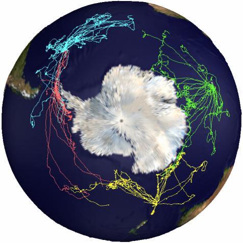
5 SPIRIT Southern Hemisphere Coverage SPIRIT Workshop, Toulouse, April 2010 ET 5


6 Background Peninsula ice shelf disintegrations, 1995-Present Collapse of the 3250 km² Larsen B ice shelf in ~1 month in Feb/March 2002 March January When the shelves were removed, tributary glaciers accelerated significantly (by factors of 2 to 6). But a controversy remains regarding their total ice loss. Scambos et al., 2003 Ant. Res. Series

7 After the collapse glacier speed-up and drawdown Larsen B ice shelf used to be here!
 DEMs Larsen A disintegration, January, 1995 All the deep fjord glaciers have accelerated and lost elevation; 50 to 150 meters (160 to 500 feet) thinning")
8 The effect of ice shelf disintegration on glacier mass balance and sea level rise Net elevation loss. Comparing ASTER 2001 and SPOT (SPIRIT) DEMs Larsen A disintegration, January, 1995 All the deep fjord glaciers have accelerated and lost elevation; 50 to 150 meters (160 to 500 feet) thinning is typical; Larsen B disintegration, March, 2002 Grounded ice volume lost: 11.2 km 3 /yr (error: ± 23%) ~0.03 mm/yr of Sea Level Rise (about 10% of the total Antarctic Ice loss) Ongoing work: Combining Icebridge data and SPIRIT 2011 DEM to update the ice loss SCAR Inlet Ice Shelf, still present (2011) (remnant of Larsen B) Shuman Berthier Scambos, JOG, 2011 Other studies using SPIRIT data in Antarctica Stearns et al., Nat Geo, 2008 & Stearns, 2011 Bindschadler et al, 2011 Scambos et al., 2011 King et al., in prep Davies, Carrivick, Glasser et al., in prep


9 Revisiting mass loss from the Greenland ice sheet & Artic glaciers and ice caps using SPIRIT DEM and images Alaska Berthier et al., Nat Geo, 2010 Rasmussen et al., JOG, 2011 Truessel et al., in prep Arctic Canada Gardner et al., in prep Toutin et al., in revision Svalbard Sund & Eiken, JOG, 2010 Moholdt et al., RSE, 2010 Memin et al., GJI, 2011 Griselin et al., CJRS, in prep Greenland Howat et al., GRL, 2011 McFadden et al., JGR, 2011 Motyka et al., JOG, 2010 Murray et al., JGR, 2010 Iceland Gudmundsson et al., PR, 2011 Adalgeirsdottir et al., TC, revised

10 PSTG, Geneva, October 2011 Arctic campaign closed Areas selected : km² Achieved coverage : 71.9% km² Antarctic campaign closed Areas selected : km² Achieved coverage : 73.9% km²


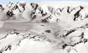
11 The SPIRIT IPY project Spot 5 stereoscopic survey of Polar Ice: Reference Images & Topographies Achievements A 6 Mill. km² archive of images SPIRIT DEM on ~100 glaciated areas totalizing 3 Mill. km². Data distributed to 44 labs / 20 countries Vilcsek Ice Cap, Franz Joseph Land

12 SPIRIT activities since 2009 Data access Access to the SPIRIT products ceased in june 2010 (contract SPOT) Development of a web based interface to access data products Preliminary version with footprints only at Access to all DEMs produced will be authorised by end 2011 PSTG, Geneva, October 2011

13 PSTG, Geneva, October 2011 ET 13
14 SPIRIT activities since 2009 Requesting new products New SPIRIT products can be requested through CNES ISIS programme ( isis.fr) ISIS provides reduced cost access to all SPOT products Labs pay ~ 5 10% of cost (rest paid for by CNES) European partner required Large capacity currently underexploited (communication?) < 30 new products generated since 2009 PSTG, Geneva, October 2011

15 PSTG, Geneva, October 2011 SPIRIT activities since 2009 Northern Hemisphere New Products generated

16 PSTG, Geneva, October 2011 SPIRIT activities since 2009 Southern Hemisphere Northern Hemisphere Products generated
.")
17 MERLIN Franco german initiative for climate studies (COP 15 à Copenhagen en dec 2009) Target launch date 2016 Agreement on phase 0/ A with DLR over the period /12. Objectif: Measure atmospheric concentration of methane to reach surface flux Financing acquired on Fr side through «Investment for the future» programme (Myriade Evolution Plateform). End of phase A scheduled for april 2012 PSTG, Geneva, October 2011


 can be linked to column")
 for the methane column")
18 PSTG, Geneva, October 2011 First DIAL Lidar in space MERLIN: measurement principal Differential absorption between laser 2 pulses at two distinct methane absorption windows (on 1,64 micron, off ) can be linked to column density Precision of better than 2% (16 à 34 ppb) for the methane column density is targeted.


 for Methane column density measurements.")
19 CNES/ill./REGY Michel, 2011 MERLIN MEthane Remote sensing LIdar mission MERLIN: MEthane Remote sensing LIdar mission MERLIN is a dedicated mission of the global methane (CH 4 ) monitoring. It is a joint French German cooperation on the development, launch and operation of a climate monitoring satellite. The MERLIN mission aims to improve the understanding of the global methane cycle and the exploration of the nature of the processes, which govern the exchange of methane between atmosphere and biosphere. Observation Method: Differential absorption of gaseous methane at two laser wavelengths reflected from Earth surface or dense clouds. Mission Duration: Launch in the timeframe of 2016 Lifetime 3 years (+ 2 years) Mission Orbit: Orbit type Sun synchronous (LTAN = 06:00) Semi major axis 6884 km Altitude 500 km Inclination 97.4 Eccentricity 10 3 Repeat cycle 28 days Attitude control 3 axis stabilised Eclipse phase 20 min / orbit during northern winter Satellite: MYRIADE Evolutions line Dimensions 800 x 800 x 1200 mm 3 Mass Power 250 kg 280 W Platform: Provided by CNES Mass 135 kg Power: 75 W Deployable solar array Battery AOCS: Star tracker Reaction wheels Payload: Type: the payload consists in an Integrated Path Differential Absorption (IPDA) LIDAR (Light Detecting And Ranging) for Methane column density measurements. Provided by DLR Contractor Astrium and Kaiser Threde Mass 95 kg Power 166 W (northern summer) Communication link: X Band downlink 150 Mbps S Band downlink 625 kbps Satellite Control Centre: Spacecraft control, monitoring, orbit control are performed by the CNES facilities located in Toulouse (France) Payload Ground Segment: User services and payload data processing are performed by the TBD facilities located in TBD Launch base and vehicle: TBD taking into account the potential co passenger opportunity and the launcher re boost capacity
20 Thank you for your attention
MERLIN: AN INTEGRATED PATH DIFFERENTIAL ABSORPTION (IPDA) LIDAR FOR GLOBAL METHANE REMOTE SENSING.
 LIDAR FOR GLOBAL METHANE REMOTE SENSING.") MERLIN: AN INTEGRATED PATH DIFFERENTIAL ABSORPTION (IPDA) LIDAR FOR GLOBAL METHANE REMOTE SENSING. ICSO 2016 International Conference on Space Optics Markus Bode / markus.bode@airbus.com 19 October 2016
MERLIN: AN INTEGRATED PATH DIFFERENTIAL ABSORPTION (IPDA) LIDAR FOR GLOBAL METHANE REMOTE SENSING. ICSO 2016 International Conference on Space Optics Markus Bode / markus.bode@airbus.com 19 October 2016
MEthane Remote sensing LIdar mission Status of MERLIN mission
 CNES/Illustration D. Ducros MEthane Remote sensing LIdar mission Status of MERLIN mission Carole DENIEL, CNES, Atmospheric Composition Programm C. Pierangelo 1, B. Millet 1, G. Ehret 2, M. Alpers 2, A.
The Polar Ice Sheets Monitoring Project A Coordinated Response from Space Agencies
 The Polar Ice Sheets Monitoring Project A Coordinated Response from Space Agencies Yves Crevier / Members of the PSTG SAR Coordination WG Canadian Space Agency CEOS SIT-28 Meeting Hampton, Virginia, USA
Floating Ice: Progress in Addressing Science Goals
 Polar Floating Ice: Progress in Addressing Science Goals Stephen Howell 1, Leif Toudal Pedersen 2 and Roberto Saldo 3 1 Environment Canada, Climate Research Division, Toronto, Canada 2 Danish Meteorological
Study Participants: T.E. Sarris, E.R. Talaat, A. Papayannis, P. Dietrich, M. Daly, X. Chu, J. Penson, A. Vouldis, V. Antakis, G.
 GLEME: GLOBAL LIDAR EXPLORATION OF THE MESOSPHERE Project Technical Officer: E. Armandillo Study Participants: T.E. Sarris, E.R. Talaat, A. Papayannis, P. Dietrich, M. Daly, X. Chu, J. Penson, A. Vouldis,
Introduction. Elevation Data Strategy. Status and Next Steps
 1 2 Introduction Elevation Data Strategy Status and Next Steps 3 Canada is the 2nd largest country in the world - 9.9 million sq km Surrounded by 3 oceans with 202 000 km of coastline Population over 35
Sentinel-1 Mission Status
 Sentinel-1 Mission Status Pierre Potin, Sentinel-1 Mission Manager, ESA Luca Martino, Technical Support Engineer, ESA... and the Sentinel-1 operations team PSTG SAR Coordination Working Group 14 December
Orbit Design Marcelo Suárez. 6th Science Meeting; Seattle, WA, USA July 2010
 Orbit Design Marcelo Suárez Orbit Design Requirements The following Science Requirements provided drivers for Orbit Design: Global Coverage: the entire extent (100%) of the ice-free ocean surface to at
SENTINEL 1 Mission status and contribution to PSTG
 PSTG SAR WG meeting, 12 September 2016, ESTEC SENTINEL 1 Mission status and contribution to PSTG First Sentinel1B Images 28 April 2016 Sentinel-1B Launch from Kourou, 25 April 2016 Sentinel 1 Mission Operations
Updates on CMA FENGYUN Meteorological Satellite Programs
 Updates on CMA FENGYUN Meteorological Satellite Programs Peng ZHANG National Satellite Meteorological Center, China Meteorological Administration (NSMC/CMA) 29 Nov. - 5 Dec. 2017, Darmstadt, Germany 1.
Sentinel-1 Mission Status
 Sentinel-1 Mission Status Pierre Potin, Sentinel-1 Mission Manager 5TH GEOGLAM RAPP Workshop 16-17 May 2017, ESRIN Sentinel-1: Copernicus radar imaging mission for ocean, land, emergency Part of the Copernicus
Sentinel-5 Precursor: Preparing the first Copernicus Atmospheric Mission
 Sentinel-5 Precursor: Preparing the first Copernicus Atmospheric Mission Herbert Nett 1, Kevin McMullan 1, Paul Ingmann 1, Thorsten Fehr 2 (1) ESA/ESTEC, Keplerlaan 1, NL-2201 AZ Noordwijk (2) ESA/ESRIN,
Pan-Arctic Digital Elevation Model - International Collaboration in Generation of ArcticDEM
 Pan-Arctic Digital Elevation Model - International Collaboration in Generation of ArcticDEM ESRI International Users Conference, June 30, 2016 Tracy Fuller, USGS Pan-Arctic DEM Technical Lead, Alaska Mapping
EUMETSAT Satellite Status
 EUMETSAT Satellite Status Dr. K. Dieter Klaes EUMETSAT 1 ET-SAT Meeting 4-6 April 2017, WMO, Geneva, Switzerland EUMETSAT is an intergovernmental organisation with 30 Member States and 1 Cooperating State
The E-SAIL programme. 10th IAA Symposium on Small Satellites for Earth Observation April 20-24, 2015 Berlin LuxSpace s.à.r.
 The E-SAIL programme 10th IAA Symposium on Small Satellites for Earth Observation April 20-24, 2015 Berlin LuxSpace s.à.r.l An OHB company Contents LuxSpace Background Consortium Spacecraft Specific issues
World Meterological Organization Polar Space Task Group
 World Meterological Organization Polar Space Task Group Jerry L. Mullins Coordinator, USGS Antarctic, Arctic and Canadian Programs Reston, VA, USA 30 September 2011 1. USGS Landsat Program 11/06 7/07 4/08
Fri. Apr. 06, Map Projections Environmental Applications. Reading: Finish Chapter 9 ( Environmental Remote Sensing )
") Fri. Apr. 06, 2018 Map Projections Environmental Applications Reading: Finish Chapter 9 ( Environmental Remote Sensing ) Once again -- Satellites old but principles still apply Skim Sabins Chapter 10.
Fri. Apr. 06, 2018 Map Projections Environmental Applications Reading: Finish Chapter 9 ( Environmental Remote Sensing ) Once again -- Satellites old but principles still apply Skim Sabins Chapter 10.
German Contributions to Earth Observation from Space WMO ET-SAT #11
 German Contributions to Earth Observation from Space Update @ WMO ET-SAT #11 Albrecht von Bargen DLR Space Administration Earth Observation Geneve (CH), April 4-6, 2017 DLR the German Aerospace Center
Spaceborne Wind Lidar Observations by Aeolus Data Products and Pre-Launch Validation with an Airborne Instrument
 DRAGON 3 Project ID 10532 Cal/Val Spaceborne Wind Lidar Observations by Aeolus Data Products and Pre-Launch Validation with an Airborne Instrument Reitebuch Oliver, Lemmerz Christian, Marksteiner Uwe,
EUMETSAT STATUS AND PLANS
 1 EUM/TSS/VWG/15/826793 07/10/2015 EUMETSAT STATUS AND PLANS François Montagner, Marine Applications Manager, EUMETSAT WMO Polar Space Task Group 5 5-7 October 2015, DLR, Oberpfaffenhofen PSTG Strategic
Remote sensing data uses and supply in Vietnam. Dr. Chu Hải Tùng National Remote Sensing Department, Ministry of Natural Resource and Environment
 Remote sensing data uses and supply in Vietnam Dr. Chu Hải Tùng National Remote Sensing Department, Ministry of Natural Resource and Environment Content Uses of remote sensing data in Vietnam Roles of
Megha-Tropiques Presentation by Indian Delegation at the 55th Session of UNCOPUOS Vienna 12 June 2012
 Megha-Tropiques Presentation by Indian Delegation at the 55 th Session of UNCOPUOS Vienna 12 June 2012 Megha-Tropiques Mission Indo-French Joint Satellite for studying tropical atmosphere Megha in Sanskrit
Operational Aspects of Space Weather-Related Missions
 Operational Aspects of Space Weather-Related Missions Richard G. Marsden, ESA/SCI-SH Outline SOHO: Example of Near-Earth Observatory-class Mission Ulysses: Example of Deep Space Monitor-class Mission Solar
Figure 1. View of ALSAT-2A spacecraft
 ALSAT-2A TRANSFER AND FIRST YEAR OPERATIONS M. Kameche (1), A.H. Gicquel (2), D. Joalland (3) (1) CTS/ASAL, 1 Avenue de la Palestine, BP 13, Arzew 31200 Oran, Algérie, email:mo_kameche@netcourrier.com
Orbital Orbital Chara Char cte act ristics eristics of the Helios of the Helio sy s s s y te st m Orbit : Low: Sun-synchronous: Quasi-polar: Phased:
 Orbital Characteristics of the Helios system Orbit : Ë Low: suitable for High Resolution imagery. ËSun-synchronous: allows for regular illumination of the observed zones as the satellite always passes
Status report on current and future satellite systems by EUMETSAT Presented to CGMS-44, Plenary session, agenda item D.1
 Status report on current and future satellite systems by EUMETSAT Presented to CGMS-44, Plenary session, agenda item D.1 CGMS-44-EUMETSAT-WP-19.ppt, version 1 (# 859110), 8 June 2016 MISSION PLANNING YEAR...
sentinel-2 COLOUR VISION FOR COPERNICUS
 sentinel-2 COLOUR VISION FOR COPERNICUS SATELLITES TO SERVE By providing a set of key information services for a wide range of practical applications, Europe s Copernicus programme is providing a step
ACHIEVING THE ERS-2 ENVISAT INTER-SATELLITE INTERFEROMETRY TANDEM CONSTELLATION.
 ACHIEVING THE ERS-2 ENVISAT INTER-SATELLITE INTERFEROMETRY TANDEM CONSTELLATION M. A. Martín Serrano (1), M. A. García Matatoros (2), M. E. Engdahl (3) (1) VCS-SciSys at ESA/ESOC, Robert-Bosch-Strasse
CH4 IPDA LIDAR MISSION DATA SIMULATOR AND PROCESSOR FOR MERLIN:
 CH4 IPDA LIDAR MISSION DATA SIMULATOR AND PROCESSOR FOR MERLIN: PROTOTYPE DEVELOPMENT AT LMD/CNRS/ECOLE POLYTECHNIQUE Chomette Olivier 1 *, Raymond Armante 1, Cyril Crevoisier 1, Thibault Delahaye 1, Dimitri
UK-DMC 2 and Deimos-1, New DMC Sensors for Agricultural Monitoring. Owen Hawkins DMC International Imaging Ltd
 UK-DMC 2 and Deimos-1, New DMC Sensors for Agricultural Monitoring Owen Hawkins DMC International Imaging Ltd Full Spectrum Satellite Solutions Design Manufacture Assembly, Integration & Test Launch Services
A Concept of Nanosatellite Small Fleet for Earth Observation
 A Concept of Nanosatellite Small Fleet for Earth Observation Prof. Janusz Narkiewicz jnark@meil.pw.edu.pl Sebastian Topczewski stopczewski@meil.pw.edu.pl Mateusz Sochacki msochacki@meil.pw.edu.pl 10-11
Global temperature record reaches one-third century
 Dec. 16, 2011 Vol. 21, No. 7 For Additional Information: Dr. John Christy, (256) 961-7763 john.christy@nsstc.uah.edu Dr. Roy Spencer, (256) 961-7960 roy.spencer@nsstc.uah.edu Global temperature record
Orbits for Polar Applications Malcolm Macdonald
 Orbits for Polar Applications Malcolm Macdonald www.strath.ac.uk/mae 25 June 2013 malcolm.macdonald.102@strath.ac.uk Slide 1 Image Credit: ESA Overview Where do we currently put spacecraft? Where else
The VENμS mission: Earth Observation with High Spatial and Temporal Resolution Capabilities
 Ben Gurion University The VENμS mission: Earth Observation with High Spatial and Temporal Resolution Capabilities G. Dedieu 1, O. Hagolle 2, A. Karnieli 3, S. Cherchali 2 P. Ferrier 2 and Y. Yaniv 4 1
ESA Status Report. ET-SAT-11, WMO, Geneva, CH, 4 April Prepared by Earth Observation Programmes Directorate
 ESA Status Report ET-SAT-11, WMO, Geneva, CH, 4 April 2017 Prepared by Earth Observation Programmes Directorate Presented by Ivan Petiteville, ESA, Earth Observation Programmes Issue/Revision: 0.0 Reference:
Aircraft Altimetry and its Application to Glaciology by Anthony Arendt for the UAF Summer School in Glaciology, June 2010
 Aircraft Altimetry and its Application to Glaciology by Anthony Arendt for the UAF Summer School in Glaciology, June 2010 1 Overview Aircraft laser altimetry is a relatively new tool in glaciology that
VNREDSat-1. Vietnam Natural Resources, Environment and Disaster monitoring Satellite. Lai Anh Khoi SPACE TECHNOLOGY INSTITUTE
 VNREDSat-1 Vietnam Natural Resources, Environment and Disaster monitoring Satellite Lai Anh Khoi SPACE TECHNOLOGY INSTITUTE JPTM2014 Yangon, Nov. 19-21, 2014 General information (1) Project Owner: Vietnam
SP-1291 June Mars Express. The Scientific Investigations
 SP-1291 June 2009 Mars Express The Scientific Investigations Operations and Archiving Mars Express Science Planning and Operations R. Pischel & T. Zegers ESA/ESTEC, Research and Scientific Support Department,
The ICESat 2 Mission Laser altimetry of ice, clouds and land elevation
 OSTM SWT San Diego October 2011 The ICESat 2 Mission Laser altimetry of ice, clouds and land elevation and also ocean, coastal, and continental waters Charon Birkett, ESSIC/UMD on behalf of T. Markus,
Status DLR (TerraSAR X / TanDEM X)
") SAR Coordination Working Meeting 5 Status DLR (TerraSAR X / TanDEM X) Dana Floricioiu, Achim Roth Imaging Requirements for TerraSAR X & TanDEM X Missions Ice Sheets: TSX supports Greenland outlet glaciers,
SAR Coordination Working Meeting 5 Status DLR (TerraSAR X / TanDEM X) Dana Floricioiu, Achim Roth Imaging Requirements for TerraSAR X & TanDEM X Missions Ice Sheets: TSX supports Greenland outlet glaciers,
CryoSat: ESA s Ice Mission:
 CryoSat: ESA s Ice Mission: 6 years in operations: status and achievements T. Parrinello CryoSat Mission Manager M. Drinkwater Mission Scientist CryoSat March 2016 sea-ice thickness CryoSat: A bit of history
Group on Earth Observations (GEO) Cold Regions Work Plan Item WA-01-C3
 Cold Regions Work Plan Item WA-01-C3") EC Panel of Experts on Polar Observations, Research and Services Group on Earth Observations (GEO) Cold Regions Work Plan Item WA-01-C3 Barbara J. Ryan Secretariat Director Lanzhou, China 13 March 2013
EC Panel of Experts on Polar Observations, Research and Services Group on Earth Observations (GEO) Cold Regions Work Plan Item WA-01-C3 Barbara J. Ryan Secretariat Director Lanzhou, China 13 March 2013
Earth Science Flight Mission Overview
 Earth Science Flight Mission Overview Nand Topiwala Science Mission Directorate NASA Headquarters April 25, 2007 Earth Science Missions Afternoon Constellation, or A-Train, Multi-Satellite Observatory
The AEOLUS Mission - In Orbit Commissioning and Verification
 The AEOLUS Mission - In Orbit Commissioning and Verification ADM-Aeolus CAL/VAL Workshop, ESRIN P McGoldrick, J Brewster, J Marshall, F Fabre Airbus Defence and Space, UK and France 12 th February 2015
Science planning and operations for Mars Express
 Science planning and operations for Mars Express René Pischel and Tanja Zegers ESA/ESTEC, Research and Scientific Support Department, Postbus 299, 2200 AG Noordwijk, The Netherlands I. Introduction The
K&C Phase 4 Status report. Ice Sheet Monitoring using ALOS-2. University of California, Irvine 2 JPL
 K&C Phase 4 Status report Ice Sheet Monitoring using ALOS-2 Bernd Scheuchl 1, Jeremie Mouginot 1, Eric Rignot 1,2 1 University of California, Irvine 2 JPL Science Team meeting #24 Tokyo, Japan, January
Sentinel-1 Long Duration Mutual Interference
 MPC-S1 Sentinel-1 Long Duration Mutual Interference Reference: Nomenclature: MPC-0432 DI-MPC-ARC Issue: 1. 0 Date: 2018,Dec.04 MPC-0432 DI-MPC-ARC V1.0 2018,Dec.04 i.1 Chronology Issues: Issue: Date: Reason
Remote Sensing 4 Global mass changes from remote sensing
 Remote Sensing 4 Global mass changes from remote sensing Nick Barrand School of Geography, Earth & Environmental Sciences University of Birmingham, UK Why glacier mass changes? o Water resources o Energy
The Quantum Sensor Challenge Designing a System for a Space Mission. Astrid Heske European Space Agency The Netherlands
 The Quantum Sensor Challenge Designing a System for a Space Mission Astrid Heske European Space Agency The Netherlands Rencontres de Moriond - Gravitation, La Thuile, 2017 Quantum Sensors in Lab Experiments
Glacier Elevation, Volume and Mass Change
 8/8/12 Glacier Elevation, Volume and Mass Change 1 Outline: Elevation, Volume and Mass Change ① Elevation change fundamentals ② Elevation measurement platforms ③ Calculating elevation change ④ Calculating
Today s Lecture: Land, biosphere, cryosphere (All that stuff we don t have equations for... )
") Today s Lecture: Land, biosphere, cryosphere (All that stuff we don t have equations for... ) 4 Land, biosphere, cryosphere 1. Introduction 2. Atmosphere 3. Ocean 4. Land, biosphere, cryosphere 4.1 Land
Today s Lecture: Land, biosphere, cryosphere (All that stuff we don t have equations for... ) 4 Land, biosphere, cryosphere 1. Introduction 2. Atmosphere 3. Ocean 4. Land, biosphere, cryosphere 4.1 Land
EUROSTAR 3000 INCLINED ORBIT MISSION : LIFETIME OPTIMISATION IN CASE OF INJECTION WITH A LOW INCLINATION
 EUROSTAR 3000 INCLINED ORBIT MISSION : LIFETIME OPTIMISATION IN CASE OF INJECTION WITH A LOW INCLINATION Franck Raballand (1), Julie De Lamarzelle (2), François Bonaventure (3), Anne-Hélène Gicquel (4)
Next generation of EUMETSAT microwave imagers and sounders: new opportunities for cloud and precipitation retrieval
 Next generation of EUMETSAT microwave imagers and sounders: new opportunities for cloud and precipitation retrieval Christophe Accadia, Sabatino Di Michele, Vinia Mattioli, Jörg Ackermann, Sreerekha Thonipparambil,
SCIENTIFIC REPORT NERC GEF
 SCIENTIFIC REPORT NERC GEF Loan 927 Measuring changes in the dynamics of Pine Island Glacier, Antarctica A.M. Smith & E.C. King, British Antarctic Survey (BAS) pp J.B.T. Scott ABSTRACT A brief period of
OTSUKIMI Moon-sighting Satellite Kyushu Institute of Technology. 3 rd Mission Idea Contest UNISEC Global
 OTSUKIMI Moon-sighting Satellite Kyushu Institute of Technology 3 rd Mission Idea Contest UNISEC Global The Idea We want to take image for the moon phases as seen from Earth Why? Introduction 1.6 billion,23.4%
Brita Horlings
 Knut Christianson Brita Horlings brita2@uw.edu https://courses.washington.edu/ess431/ Natural Occurrences of Ice: Distribution and environmental factors of seasonal snow, sea ice, glaciers and permafrost
Meltdown Evidence of Climate Change from Polar Science. Eric Wolff
 Meltdown Evidence of Climate Change from Polar Science Eric Wolff (ewwo@bas.ac.uk) Why are the polar regions important for climate? Heat engine Why are the polar regions important for climate? Heat engine
Status of the Sentinel-5 Precursor Presented by C. Zehner S5p, S4, and S5 Missions Manager - ESA
 Status of the Sentinel-5 Precursor Presented by C. Zehner S5p, S4, and S5 Missions Manager - ESA European response to global needs: to manage the environment, to mitigate the effects of climate change
ESA s Juice: Mission Summary and Fact Sheet
 ESA s Juice: Mission Summary and Fact Sheet JUICE - JUpiter ICy moons Explorer - is the first large-class mission in ESA's Cosmic Vision 2015-2025 programme. Planned for launch in 2022 and arrival at Jupiter
ASCAT - Metop A developments, Metop B preparations & EPS-SG
 ASCAT - Metop A developments, Metop B preparations & EPS-SG Hans Bonekamp, Craig Anderson, Julia Figa & Julian Wilson Slide: 1 ASCAT Metop A - overview Instrument operating nominally (minor incident in
Information furnished in conformity with the Convention on Registration of Objects Launched into Outer Space
 United Nations Secretariat Distr.: General 4 August 2008 English Original: [Start1] Committee on the Peaceful Uses of Outer Space Information furnished in conformity with the Convention on Registration
RECENT SPACE DEBRIS MITIGATION ACTIVITIES IN FRANCE F.ALBY
 RECENT SPACE DEBRIS MITIGATION ACTIVITIES IN FRANCE F.ALBY GEO END OF LIFE WORKSHOP BACKGROUND Particularity of the GEO orbit: unique resource Need to protect and to keep available orbital positions Mitigation
GSC 107 Lab # 3 Calculating sea level changes
 GSC 107 Lab # 3 Calculating sea level changes Student name Student ID Background Glacial-Interglacial Cycles Climate-related sea-level changes of the last century are very minor compared with the large
Joint Polar Satellite System. 3 rd Post-EPS User Consultation Workshop Mike Haas
 3 rd Post-EPS User Consultation Workshop Mike Haas Overview Introduction - Policy Drivers - Management System Description - Space Segment - Ground Segment Partnerships Status Benefits 2 Introduction (Policy
NASA Images of Antarctica and the Arctic covered in both land and sea ice
 ICE SHELVES ACTIVITY 1: DECODING THE ROLE OF ANTARCTIC ICE IN GLOBAL CLIMATE Ice Shelves play a critical role in Antarctica, serving as a buffer between the ocean and the continental ice sheet covering
HY-2A Satellite User s Guide
 National Satellite Ocean Application Service 2013-5-16 Document Change Record Revision Date Changed Pages/Paragraphs Edit Description i Contents 1 Introduction to HY-2 Satellite... 1 2 HY-2 satellite data
Perspectivas del Programa Científico de la Agencia Espacial Europea
 Perspectivas del Programa Científico de la Agencia Espacial Europea Encuentro RIA-SpaceTec: Instrumentación astronómica en España 3 octubre - 2018 Pilar Román Delegación española en la ESA AGENDA 1. Organización
System and Concurrent Engineering for the e.deorbit Mission Assessment Studies Robin Biesbroek Jakob Hüsing Andrew Wolahan
 System and Concurrent Engineering for the e.deorbit Mission Assessment Studies Robin Biesbroek Jakob Hüsing Andrew Wolahan Why Active Debris Removal? 17000 catalogued objects Less than 1000 active 600-800
An Overview. Jeff Key (NOAA) PSTG Vice-Chair. on behalf of Polar Space Task Group. Polar Space Task Group
 PSTG Vice-Chair. on behalf of Polar Space Task Group. Polar Space Task Group") An Overview Jeff Key (NOAA) PSTG Vice-Chair on behalf of Asia CryoNet Meeting 4 December 2013, Beijing Cryosphere Satellite Missions International Year (IPY) The IPY provided an international framework
An Overview Jeff Key (NOAA) PSTG Vice-Chair on behalf of Asia CryoNet Meeting 4 December 2013, Beijing Cryosphere Satellite Missions International Year (IPY) The IPY provided an international framework
C o p e r n i c u s a n d W I G O S
 C o p e r n i c u s a n d W I G O S Jean-Noël Thépaut & Mark Dowell 24 October 2017 GEO XIV, Washington DC, 23-28 October 2017 T h e C o p e r n i c u s P r o g r a m m e Copernicus is the European Union
DARE Mission and Spacecraft Overview
 DARE Mission and Spacecraft Overview October 6, 2010 Lisa Hardaway, PhD Mike Weiss, Scott Mitchell, Susan Borutzki, John Iacometti, Grant Helling The information contained herein is the private property
- satellite orbits. Further Reading: Chapter 04 of the text book. Outline. - satellite sensor measurements
 (1 of 12) Further Reading: Chapter 04 of the text book Outline - satellite orbits - satellite sensor measurements - remote sensing of land, atmosphere and oceans (2 of 12) Introduction Remote Sensing:
Balloons - Stable Platforms for Payloads in the Higher Atmosphere
 Balloons - Stable Platforms for Payloads in the Higher Atmosphere The application of balloons for scientific use as a supplement to satellites and ground based instruments has increased in particular during
FLUXNET and Remote Sensing Workshop: Towards Upscaling Flux Information from Towers to the Globe
 FLUXNET and Remote Sensing Workshop: Towards Upscaling Flux Information from Towers to the Globe Space-Based Measurements of CO 2 from the Japanese Greenhouse Gases Observing Satellite (GOSAT) and the
UrtheCast s High Resolution Imagery, HD Video and Synthetic Aperture Radar from Space for Smart Earth Observations Dr. Rao S.
 UrtheCast s High Resolution Imagery, HD Video and Synthetic Aperture Radar from Space for Smart Earth Observations Dr. Rao S. Ramayanam Vice President Middle East, Africa and South Asia Geo Smart Asia
DE-ORBITATION STUDIES AND OPERATIONS FOR SPIRALE GTO SATELLITES
 DE-ORBITATION STUDIES AND OPERATIONS FOR SPIRALE GTO SATELLITES François BONAVENTURE (1), Slim LOCOCHE (2), Anne-Hélène GICQUEL (3) (1) Tel. (+33) (0)5 62 19 74 27, E-mail. francois.bonaventure@astrium.eads.net
SPIRIT. SPOT 5 stereoscopic survey of Polar Ice: Reference Images and Topographies during the fourth International Polar Year ( )
") SPIRIT. SPOT 5 stereoscopic survey of Polar Ice: Reference Images and Topographies during the fourth International Polar Year (2007-2009) Jérôme Korona, Etienne Berthier, Marc Bernard, Frédérique Rémy,
SPIRIT. SPOT 5 stereoscopic survey of Polar Ice: Reference Images and Topographies during the fourth International Polar Year (2007-2009) Jérôme Korona, Etienne Berthier, Marc Bernard, Frédérique Rémy,
Opportunities for advanced Remote Sensing; an outsider s perspective
 Opportunities for advanced Remote Sensing; an outsider s perspective Ramon Hanssen Delft University of Technology 1 Starting questions Can we do more with the data we are already acquire? What s in stock
Research Programme Polar, Marine and Coastal Systems. Current and future Arctic research priorities of Germany Nicole Biebow, AWI
 Research Programme Polar, Marine and Coastal Systems Current and future Arctic research priorities of Germany Nicole Biebow, AWI Arctic Science and Technology (S&T) Collaboration and Engagement Workshop,
PROBA 1. F. Teston ESA/ESTEC D/TEC-EL
 PROBA 1 F. Teston ESA/ESTEC D/TEC-EL Frederic.Teston@esa.int PROBA 1 launch PROBA 1 has been launched on 21 October 2001 Orbital parameters: Altitude: 681-561 km Near polar (inclination of 97.9 ) Sun-synchronous
Components of the Climate System. Lecture 2: Earth s Climate System. Pop Quiz. Sub-components Global cycles What comes in What goes out
 Lecture 2: Earth s Climate System Components of the Climate System terrestrial radiation Atmosphere Ocean solar radiation Land Energy, Water, and Biogeochemistry Cycles Sub-components Global cycles What
The recent retreat of glaciers in the world
 The recent retreat of glaciers in the world Consequences for the global environment Dr Bernard Francou Director of Research Emeritus Grenoble-Alpes University - France Glaciers are part of the cryosphere
The In-Orbit Commissioning of MSG-1
 Earth Observation The In-Orbit Commissioning of MSG-1 MSG Project Team, Earth Observation Projects Department, ESA Directorate of Earth Observation, ESTEC, Noordwijk, The Netherlands 80 esa bulletin 114
SAMPLE PAGE. pulses. The Ice Age By: Sue Peterson
 Page 61 Objective sight words (pulses, intermittent, isotopes, chronicle, methane, tectonic plates, volcanism, configurations, land-locked, erratic); concepts (geological evidence and specific terminology
March was 3rd warmest month in satellite record
 April 4, 2016 Vol. 25, No. 12 For Additional Information: Dr. John Christy, (256) 961-7763 john.christy@nsstc.uah.edu Dr. Roy Spencer, (256) 961-7960 roy.spencer@nsstc.uah.edu Global Temperature Report:
Lecture 2: Earth s Climate System
 Lecture 2: Earth s Climate System terrestrial radiation solar radiation Atmosphere Ocean Solid Earth Land Energy, Water, and Biogeochemistry Cycles Sub-components Global cycles What comes in What goes
Julia Figa-Saldaña & Klaus Scipal
 Julia Figa-Saldaña & Klaus Scipal julia.figa@eumetsat.int klaus.scipal@esa.int Meeting, Outline MetOp/EPS status MetOp/EPS Second Generation status 2016 scatterometer conference Other European ocean programme
Subsidence Monitoring in Hampton Roads Using InSAR
 Subsidence Monitoring in Hampton Roads Using InSAR Ben Hamlington, David Bekaert, Cathleen Jones, Brett Buzzanga, John Murray Commonwealth Center for Recurrent Flooding Resiliency (CCRFR) NASA Jet Propulsion
MISSION ENGINEERING SPACECRAFT DESIGN
 MISSION ENGINEERING & SPACECRAFT DESIGN Alpbach 2007 - D.J.P. Moura - CNES MISSION ENGINEERING (1) OVERALL MISSION ENGINEERING IS A COMPLEX TASK SINCE AT THE BEGINNING THE PROBLEM IS GENERALLY BADLY EXPRESSED
EUMETSAT SAF NETWORK. Lothar Schüller, EUMETSAT SAF Network Manager
 1 EUMETSAT SAF NETWORK Lothar Schüller, EUMETSAT SAF Network Manager EUMETSAT ground segment overview METEOSAT JASON-2 INITIAL JOINT POLAR SYSTEM METOP NOAA SATELLITES CONTROL AND DATA ACQUISITION FLIGHT
Welcome to PolarConnect. With Kelly McCarthy and NASA s Operation IceBridge
 Welcome to PolarConnect With Kelly McCarthy and NASA s Operation IceBridge 5 May 2016 If you are joining by phone, please mute your phone. Press *6 to mute and *6 to unmute. Participant Introductions In
Towards eenvironment Prague, March GMES Space Component. Josef Aschbacher Head, ESA GMES Space Office
 Towards eenvironment Prague, 25-27 March 2009 GMES Space Component Josef Aschbacher Head, ESA GMES Space Office Prague from Space Segment 2 05 Nov 2003 CNES 2003 GISAT 2007 ESA GSELAND GMES is an EU led
Laser de-spin maneuver for an active debris removal mission - a realistic scenario for Envisat
 Laser de-spin maneuver for an active debris removal mission - a realistic scenario for Envisat Daniel Kucharski Space Environment Research Centre, Mt Stromlo Observatory, Weston Creek ACT, 2611, AUSTRALIA
ESA activities towards the Gravitation Waves Space Observatory
 ESA activities towards the Gravitation Waves Space Observatory Frédéric Safa ESA Science Directorate, Future Missions LISA Symposium, Zurich 2016 The Gravitation Wave Observatory in ESA Science Programme
Determining the spatio-temporal distribution of 20th Century Antarctic Peninsula glacier mass change
 Determining the spatio-temporal distribution of 20th Century Antarctic Peninsula glacier mass change Jon Mills, Pauline Miller, Matthias Kunz School of Civil Engineering & Geosciences / Centre for Earth
Polar Space Task Group Space Agency Report
 Polar Agency Report EUMETSAT WMO HQ, Geneva 16-18 October, 2018 EUMETSAT News EPS OSI SAF products Sentinel-3 PSTG8 Meeting, WMO, 16-18 Oct., 2018 EUMETSAT Polar System: Metop- C Launch Preparation Metop-C
DLR/TerraSAR-X: development of IPY portofolio since the SAR coordination workshop (CSA, March 2008) Dana Floricioiu
 Dana Floricioiu") DLR/TerraSAR-X: development of IPY portofolio since the SAR coordination workshop (CSA, March 2008) Dana Floricioiu STG-3 Meeting, ESRIN Frascati 5/6 May 2008 Acquisitions themes adopted at the SAR coordination
DLR/TerraSAR-X: development of IPY portofolio since the SAR coordination workshop (CSA, March 2008) Dana Floricioiu STG-3 Meeting, ESRIN Frascati 5/6 May 2008 Acquisitions themes adopted at the SAR coordination
Systems Engineering in Venus Satellite
 Systems Engineering in Venus Satellite How to benefit from system engineering process in designing a microsatellite Jacob Herscovitz Venus Project Manager RAFAEL - Israel 1 Presentation Contents Introduction
Ice & Snow Session. Chairs: J. Mouginot & N. Gourmelen
 Ice & Snow Session Chairs: J. Mouginot & N. Gourmelen Session 12 talks and 10 posters Antarctic ice motion, ground-line detection and monitoring, dynamics ice-fluctuations in Antarctica and Greenland,
SMALL SATELLITES FOR AN OPERATIONAL AIR QUALITY SERVICE. Bryan de Goeij, Zeger de Groot, Jeroen Rotteveel, Nick van der Valk and Gerard Otter
 SMALL SATELLITES FOR AN OPERATIONAL AIR QUALITY SERVICE Bryan de Goeij, Zeger de Groot, Jeroen Rotteveel, Nick van der Valk and Gerard Otter OUTLINE Introduction Mission definition Mission goal and requirements