Trawl-mounted video camera observations of snow crab interaction with footgear
|
|
|
- Ashlee Stewart
- 5 years ago
- Views:
Transcription
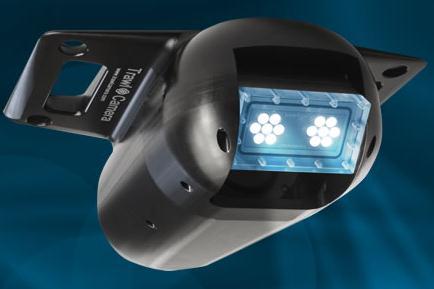
1 Trawl-mounted video camera observations of snow crab interaction with footgear Truong Nguyen 1, Paul Winger 1, George Legge 1, Earl Dawe 2, and Darrell Mullowney 2 1 Fisheries and Marine Institute, Memorial University 2 Fisheries and Oceans Canada
2 Purpose: Conduct trawl-mounted video camera observations of trawl footgear interacting with snow crab (including soft-shelled) on varying substrates. The goal was to provide insight into how individual crab interact with footgear components.


3 Materials and Methods:


4

5


6
7 Start Start End End Depth (ftm) Tow No. Date Time Latitude Longitude Time Latitude Longitude Heading 1 June 19, : : June 19, : a a 09: a a June 19, : : June 19, : : June 19, : : June 19, : : June 20, : : June 20, : : June 20, : : June 20, : : June 20, : : June 21, : :26 b June 21, : : June 21, : : June 21, : :
8 Tow No. Camera Location Total Video (min)* Usable Video (min)** Comments 11 SD camera with 33% light (30 0 angle) was attached to fishing line of bosom section. 12 SD camera with 33% light (30 0 angle) was attached to fishing line of bosom section (as Tow 11) Light on camera caused reflection with suspended sediment in water. However, we were still able to examine a part of the bosom section. Two hard shelled crabs on GRID with no limb loss. One semi softshelled crab in pot with no limb loss Light on camera caused reflection with suspended sediment in water. However, we were still able to examine a part of bosom section. 13 SD camera with 33% light (30 0 angle) was mounted on the port side end of bosom section on fishing line. 14 SD camera with light off (30 0 angle) was mounted on fishing line of bosom section. Camera 2xLED with 100% was attached to headline pointing down to bosom section. 15 SD camera with 33 % light (30 0 angle) was mounted on fishing line of bosom section. Camera 2xLED with 66% was attached to headline pointing down to bosom section Light on camera caused reflection with suspended sediment in water. However, we were still able to examine a part of bosom section Fewer crab observed. No reflection with suspended sediment was found as in Tow It seemed to be easier to see footgear/crab interaction, but not really clearly as the turbid water Light on camera caused reflection with suspended sediment in water. However, we were still able to examine a part of bosom section.
9 Different Substrates Video Clip 1 Video Clip 2

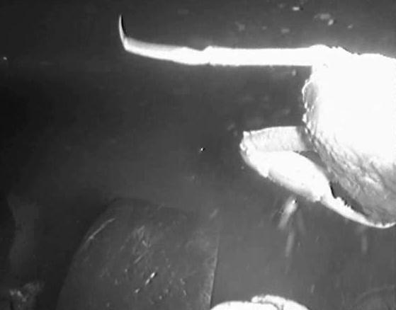
10 Results: 1081 crab were observed

11


12 Examples of snow crab in the mud


13 Examples of snow crab on the surface

14 180 Numbers of crab observed by size Small Large 0 Tow 11 Tow 12 Tow 13 Tow 14 Tow 15

15

16


17

18


19 Video clip


20 Orientation of snow crab on or in the substrate relative to the centre of the footgear. Bars indicate percentage of individuals. The black line indicates the mean direction (193 ). A total of 1081 observations were included in the analysis. The Rayleigh test concluded that the orientation was non-random.
21 Direction of snow crab movement on the substrate relative to the centre of the footgear. Bars indicate percentage of individuals. The black line indicates the mean direction (1.85 ). A total of 938 observations were considered moving and included in the analysis. The Rayleigh test concluded that the direction of movement was non-random.
22 Other Interesting Observations? Images of Crab with Missing Limbs Interaction of the Shrimp Trawl with a Lost Crab Trap
23 Conclusions: Majority of crab were on the surface of the substrate. Majority of crabs were moving. 53% of crabs observed experienced a collision with the footgear (either disc or spacer/chain). Majority of collisions were less than 1 second. Majority of crabs passed under the footgear. Majority of crabs appeared to be aware of the footgear and are actively responding/reacting.
24 Recommendations: Conduct trawl modification to reduce impacts. Collect more video: - Other gear components (i.e. wires/doors or wing-sections). - Other substrates. - Higher crab densities. - Other footgear types (e.g. bobbin footgear).
25 He and Winger (2010)


26 Injury rates ranged between 3.3 and 10%, depending on the footgear type.
27 Ongoing Work: Two NL trawl manufacturers have been experimenting with seabed friendly versions of: 1) trawl footgear 2) semi-pelagic trawl doors. Flume tank experiments and preliminary field trials have been conducted. More field trials planned for this summer!!!


28 Funding Support Provided By:
29 THANK-YOU Paul Winger, PhD Centre for Sustainable Aquatic Resources Fisheries and Marine Institute of Memorial University of Newfoundland Web:
Spatial Planning in Canada s Maritimes Region. Maritimes Region
 Spatial Planning in Canada s Maritimes Region Glen Herbert, Scott Coffen-Smout Smout,, and Tanya Koropatnick Oceans and Coastal Management Division Ecosystem Management Branch Fisheries and Oceans Canada
Notice to Mariners. Rampion Offshore Wind Farm Date of Issue: 12/01/2018 Notice Expires: Ongoing
 Dear Authorities, Owners, Ships Agents, Masters, Pilots and Fishermen, Re: - Installation of New East Export cable update. This NTM supersedes and closes out NTM 87 The Stemat Spirit has completed removal
W. R. Bowering and D. Power Northwest Atlantic Fisheries Centre, P. O. Box 5667 St. John s, Newfoundland, Canada A1C 5X1. Abstract
 NAFO Sci. Coun. Studies, 22: 51 61 Spatial Distribution of Greenland Halibut (Reinhardtius hippoglossoides (Walbaum)) in the Labrador-Eastern Newfoundland Area of the Canadian Northwest Atlantic W. R.
Spatial variation in the abundance of eelgrass (Zostera marina) at eight sites in western Newfoundland, Canada 5/5/2015 V2.0
 at eight sites in western Newfoundland, Canada 5/5/2015 V2.0") Spatial variation in the abundance of eelgrass (Zostera marina) at eight sites in western Newfoundland, Canada 5/5/2015 V2.0 1 Summary The abundance of eelgrass (Zostera marina) was quantified at eight
Spatial variation in the abundance of eelgrass (Zostera marina) at eight sites in western Newfoundland, Canada 5/5/2015 V2.0 1 Summary The abundance of eelgrass (Zostera marina) was quantified at eight
National Marine Sanctuary Program
 National Marine Sanctuary Program NMSP/USGS Joint Seabed Mapping Initiative: September 2004 AA National Ocean Service National Marine Sanctuaries Interim Report September 2004 Background: Since 2002,
Spatial dynamics of small pelagic fish in the California Current system on the regime time-scale. Parallel processes in other species-ecosystems.
 PICES/GLOBEC Symposium Honolulu, Hawaii April 19-21, 2006 Spatial dynamics of small pelagic fish in the California Current system on the regime time-scale. Parallel processes in other species-ecosystems.
Socioeconomic Profile and Spatial Analysis of Fisheries in the three central California National Marine Sanctuaries
 Socioeconomic Profile and Spatial Analysis of Fisheries in the three central California National Marine Sanctuaries 23 + 30 March 2004 Charles Steinback and Astrid Scholz Outline Who we are and why we
Arctic stowaways: the potential for species introduction to occur in Svalbard associated with shipping Progress report January 2012
 Arctic stowaways: the potential for species introduction to occur in Svalbard associated with shipping Progress report January 2012 Chris Ware, Inger Greve Alsos Jørgen Berge, Jan H. Sundet og Per Arneberg
SUT WA Research Night
 SUT WA Research Night An introduction to acoustic seafloor observation and geostatistical data interpolation Elizabeth Mair BSc (GIS) Honours Curtin University Contents Project Introduction Methodology
Climate change, ocean acidification and individual-based models: Why the little things matter
 Climate change, ocean acidification and individual-based models: Why the little things matter Author Richards, Russell, Meynecke, Olaf, Chaloupka, M, Tomlinson, Rodger Benson Published 2012 Conference
Name/ Affiliation: Ben Enticknap, Fishery Project Coordinator Alaska Marine Conservation Council Address: PO Box Anchorage, AK 99510
 Habitat Areas of Particular Concern (HAPC) Proposal Name/ Affiliation: Ben Enticknap, Fishery Project Coordinator Alaska Marine Conservation Council Address: PO Box 101145 Anchorage, AK 99510 Please check
Create your own map for tidepooling, beach field trips, boating, camping, kayaking, fishing, and exploring the beaches in Southcentral Alaska.
 Create your own map for tidepooling, beach field trips, boating, camping, kayaking, fishing, and exploring the beaches in Southcentral Alaska. Here s an opportunity to download and customize your own free
Urban Geography. Unit 7 - Settlement and Urbanization
 Urban Geography Unit 7 - Settlement and Urbanization Unit 7 is a logical extension of the population theme. In their analysis of the distribution of people on the earth s surface, students became aware
European Migration to Tilting, Newfoundland
 European Migration to Tilting, Newfoundland Lesson Overview In this lesson, students will learn about historical connections between Tilting, Newfoundland and Labrador, and Ireland. Using the Canadian
Re: Experimental Evaluation of Fishway Modifications on the Passage Behavior of Adult Pacific Lamprey at Bonneville Dam
 Page 1 Summary Report To: David Clugston, USACE From: Eric Johnson, Matt Keefer, and Chris Peery (Fish Ecology Research Laboratory, University of Idaho), and Mary Moser (Northwest Fisheries Science Center,
Marine Ecology Pacing Guide
 Marine Ecology Pacing Guide Course Description: The focus of the course is the interrelationships among marine organisms and the physical, chemical, geological and biological factors. North Carolina coastal
Ecological and Economic Effects of Derelict Fishing Gear in the Chesapeake Bay. Amy V. Uhrin Chief Scientist NOAA Marine Debris Program
 Ecological and Economic Effects of Derelict Fishing Gear in the Chesapeake Bay Amy V. Uhrin Chief Scientist NOAA Marine Debris Program Briefing for: Chesapeake Bay Program Management Board October 13,
Geospatial dynamics of Northwest. fisheries in the 1990s and 2000s: environmental and trophic impacts
 Geospatial dynamics of Northwest Atlantic ti cod and crustacean fisheries in the 1990s and 2000s: environmental and trophic impacts Matthew J.S. WINDLE 1, George A. ROSE 2, Rodolphe DEVILLERS 3, and Marie-Josée
This Presentation Will Cover
 April 18, 2017 Elizabeth Chilton, Acting Branch Chief Fisheries Sampling Branch Amy Martins, Acting Division Chief Fishery Monitoring & Research Division Northeast Fisheries Science Center, Woods Hole,
Project 1.3.1: Improved knowledge of biota, habitats and risks. Project Leader: Dr Mick Haywood, CSIRO Division of Marine and Atmospheric Research
 Marine and Tropical Sciences Research Facility (MTSRF) June 2007 Milestone Report Project 1.3.1: Improved knowledge of biota, habitats and risks Project Leader: Dr Mick Haywood, CSIRO Division of Marine
ASEAN Trans-Boundary Marine Debris and Consortium for Indonesia Oceanic Research
 ASEAN Trans-Boundary Marine Debris and Consortium for Indonesia Oceanic Research Dr. Mutiara Rachmat Putri Research Group of Oceanography Institut Teknologi Bandung, INDONESIA Regional Workshop in support
Implications of fisheries impacts to seafloor biodiversity and Ecosystem-Based Management
 Implications of fisheries impacts to seafloor biodiversity and Ecosystem-Based Management Simon F. Thrush Institute of Marine Science The University of Auckland New Zealand ICES symposium - The Effects
2001 State of the Ocean: Chemical and Biological Oceanographic Conditions in the Newfoundland Region
 Stock Status Report G2-2 (2) 1 State of the Ocean: Chemical and Biological Oceanographic Conditions in the Background The Altantic Zone Monitoring Program (AZMP) was implemented in 1998 with the aim of
Relatively little hard substrate occurs naturally in the
 CHAPTER FIVE Rock Habitats Relatively little hard substrate occurs naturally in the estuary, owing mainly to the vast quantities of fine sediment that have been deposited by the rivers. Rock habitat is
Experimental Investigation on Density Currents Propagating over Smooth and Rough Beds
 Experimental Investigation on Density Currents Propagating over Smooth and Rough Beds Reza Nasrollahpour 1, Mohamad Hidayat Bin Jamal 2*, Mehdi Ghomeshi 3, Peiman Roushenas 4 1,2,4 Faculty of Civil Engineering,
In situ characterisation of habitats adjoining cold water coral reefs using a Sediment Profile Imagery (SPI) camera
 camera") In situ characterisation of habitats adjoining cold water coral reefs using a Sediment Profile Imagery (SPI) camera Silvana N.R. Birchenough, Nigel Lyman, David A. Roberts, Juan Moreno Navas and J. Murray
In situ characterisation of habitats adjoining cold water coral reefs using a Sediment Profile Imagery (SPI) camera Silvana N.R. Birchenough, Nigel Lyman, David A. Roberts, Juan Moreno Navas and J. Murray
Preliminary Earthquake Report
 THE UNIVERSITY OF THE WEST INDIES ST. AUGUSTINE, TRINIDAD AND TOBAGO, WEST INDIES THE SEISMIC RESEARCH CENTRE Telephone: (868) 662-4659 E-mail: uwiseismic@uwiseismic.com Website: http://uwiseismic.com
DSC HW 3: Assigned 6/25/11, Due 7/2/12 Page 1
 DSC HW 3: Assigned 6/25/11, Due 7/2/12 Page 1 Problem 1 (Motor-Fan): A motor and fan are to be connected as shown in Figure 1. The torque-speed characteristics of the motor and fan are plotted on the same
APPENDIX A. Study Team Member Profiles
 APPENDIX A Study Team Member Profiles APPENDIX A Eugene Lee, M.Sc. 28) was an AMEC Senior environmental/aquatic biologist/project manager with 23 years consulting experience. Mr. Lee has extensive experience
CLT/HER/CHP/OG 1- page 29
 CLT/HER/CHP/OG 1- page 29 MODEL INVENTORY SHEET FOR UNDERWATER CULTURAL HERITAGE COUNTRY REGION, PROVINCE COMPETENT AUTHORITY REGISTERED BY (name, position) Date Email / Tel nº SITE NAME (provide also
Physics and Physical Oceanography Data Report Analysis of Physical Oceanographic Data from Funk Island Bank, August 2004
 Physics and Physical Oceanography Data Report 2004-2 Analysis of Physical Oceanographic Data from Funk Island Bank, August 2004 Nicholas Record, Brad de Young, and Jack Foley 2004 Department of Physics
Post-Graduation Plans stock assessment scientist (NOAA, hopefully)
") Update Report Period 3/1/2013-2/28/2014 Project E/I-20 - NMFS Population Dynamics Sea Grant Graduate Fellowship An evaluation of the stock assessment method for eastern Bering Sea snow crab incorporating
Update Report Period 3/1/2013-2/28/2014 Project E/I-20 - NMFS Population Dynamics Sea Grant Graduate Fellowship An evaluation of the stock assessment method for eastern Bering Sea snow crab incorporating
Climate Change in Newfoundland & Labrador
 Climate Change in Newfoundland & Labrador Impacts and Adaptation Newleef Conference 08 October 2015 Met-Ocean Services The Team 55 personnel; 24/7 operational weather forecast desk; Equipment technician
SOUTHAMPTON OCEANOGRAPHY CENTRE. CRUISE REPORT No. 40 RRS CHARLES DARWIN CRUISE MAR - 20 MAR 2001
 SOUTHAMPTON OCEANOGRAPHY CENTRE CRUISE REPORT No. 40 RRS CHARLES DARWIN CRUISE 126 11 MAR - 20 MAR 2001 Piston coring of debris flows and turbidites west and south of the Canary Islands Principal Scientist
CRUISE SUMMARY REPORT
 CRUISE SUMMARY REPORT Centre: DOD Ref. No.: FOR COLLATIMG CENTRE USE Is data exchange restricted Yes In part No Page 1 SHIP enter the full name and international radio call sign of the ship from which
Distributional changes of west coast species and impacts of climate change on species and species groups
 Distributional changes of west coast species and impacts of climate change on species and species groups Elliott Hazen 1 Ole Shelton 2 Eric Ward 2 1 NOAA Southwest Fisheries Science Center 2 NOAA Northwest
Vision: The National Oceanography Centre will, by 2015, be recognised as the world-leading Centre for integrated ocean sciences and technology".
 National Oceanography Centre from coast to deep ocean Waterfront Campus, Southampton Vision: Joseph Proudman Building, Liverpool The National Oceanography Centre will, by 2015, be recognised as the world-leading
wikihow to Find True North Without a Compass
 wikihow to Find True North Without a Compass wikihow.com /Find-True-North-Without-a-Compass Which way is north? Whether you're lost in the woods or you're trying to install a sundial in your yard, you're
The East of Nantucket Survey. Preliminary Results Presented by Eric Powell to the Habitat PDT on September 14, 2017
 The East of Nantucket Survey Preliminary Results Presented by Eric Powell to the Habitat PDT on September 14, 2017 Thanks Roger Mann who handled the logistics of the cruise Tom Dameron and others who provided
6 th Meeting of the Scientific Committee Puerto Varas, Chile, 9-14 September 2018
 6 th Meeting of the Scientific Committee Puerto Varas, Chile, 9-14 September 2018 SC6-DW11 Methods for designing spatial management areas using outputs from Zonation software and other spatial data Martin
AN EXPERIMENTAL STUDY ON SAND DUNE SEDIMENT TRANSPORT DUE TO TSUNAMI OVERWASH. K M Ahtesham Hossain Raju 1 and Shinji Sato 2
 AN EXPERIMENTAL STUDY ON SAND DUNE SEDIMENT TRANSPORT DUE TO TSUNAMI OVERWASH K M Ahtesham Hossain Raju 1 and Shinji Sato 2 Response of sand dune when overwashed by tsunami or storm surge, is investigated
Why Erosion and Sedimention Control is Important: A Fish s Point of View
 Why Erosion and Sedimention Control is Important: A Fish s Point of View Fisheries Protection Program Department of Fisheries and Oceans June 6, 2014 Basic definition: Sediment is defined as soil particles
Computer Simulation of Sand Ripple Growth and Migration.
 Computer Simulation of Sand Ripple Growth and Migration. Douglas J. Wilson OGI School of Environmental Science and Engineering at the Oregon Health and Sciences University 20000 N.W. Walker Road, Beaverton,
APPLICATION FOR THE CONSENT TO CONDUCT MARINE SCIENTIFIC RESEARCH IN AREAS UNDER NATIONAL JURISDICTION OF THE UNITED KINGDOM
 APPLICATION FOR THE CONSENT TO CONDUCT MARINE SCIENTIFIC RESEARCH IN AREAS UNDER NATIONAL JURISDICTION OF THE UNITED KINGDOM 1. General information Date: 27 th January 2011 1.1 Cruise name and/or number:
NOAA Deep Sea Coral Research and Technology Program
 NOAA Deep Sea Coral Research and Technology Program Robert McGuinn, Conservation Biologist Data System Manager Robert.McGuinn@noaa.gov 843-762-8640 Presentation Update: 03/23/2015 NOAA - NMFS DSC-RTP Tom
Your web browser (Safari 7) is out of date. For more security, comfort and the best experience on this site: Update your browser Ignore
 is out of date. For more security, comfort and the best experience on this site: Update your browser Ignore") Your web browser (Safari 7) is out of date. For more security, comfort and the best experience on this site: Update your browser Ignore PL ANKTO N REVEALED A critical component of life on Earth For the
Your web browser (Safari 7) is out of date. For more security, comfort and the best experience on this site: Update your browser Ignore PL ANKTO N REVEALED A critical component of life on Earth For the
Review 5 Themes of Geography
 Review 5 Themes of Geography Five Themes of Geography Location Place Human-Environment Interaction Movement Regions Theme 1: Absolute Location Every point on earth can be determined using an imaginary
Trial Application of the BDEP Template for Summarizing Bycatch Data. Williams, Smith et al. EB SWG WP-12
 Trial Application of the BDEP Template for Summarizing Bycatch Data Williams, Smith et al. EB SWG WP-12 SC 12, Bali, Indonesia, 3-11 August 2016 Background Presentation Outline Methodology and issues dealt
The Proposed Strait of Belle Isle Cable Crossing
 PT-13: Coastal and Ocean Engineering ENGI.8751 Undergraduate Student Forum Faculty of Engineering and Applied Science, Memorial University, St. john s, NL, Canada March, 2013 Paper Code. (PT-13 - White)
Winter Skate Leucoraje ocellata.
 Addendum to COSEWIC 2015 Status Report for the Winter Skate Leucoraje ocellata. 2017 Fisheries and Oceans Canada (DFO) has requested that COSEWIC reconsider the designatable unit (DU) structure for Winter
European Commission STUDY ON INTERIM EVALUATION OF EUROPEAN MARINE OBSERVATION AND DATA NETWORK. Executive Summary
 European Commission STUDY ON INTERIM EVALUATION OF EUROPEAN MARINE OBSERVATION AND DATA NETWORK Executive Summary by NILOS Netherlands Institute for the Law of the Sea June 2011 Page ii Study on Interim
Rock Boulder RockSand 1 RockSand 2 RockSand 3 Sand
 Figure 15. Histogram comparison of ROV observed primary substrates determined from 33,605 dgps positions to RoxAnn seabed classification. Pie charts represent the percentage of ROV modified primary substrate
Near-Field Sturgeon Monitoring for the New NY Bridge at Tappan Zee. Quarterly Report October 1 December 31, 2014
 Near-Field Sturgeon Monitoring for the New NY Bridge at Tappan Zee Quarterly Report October 1 December 31, 2014 Prepared by AKRF, Inc. 7250 Parkway Drive, Suite 210 Hanover, MD 21076 for New York State
Chapter 7 Benthic deep-sea carbonates: reefs and seeps
 Chapter 7 Benthic deep-sea carbonates: reefs and seeps Carbonates are formed across most latitudes and they are not restricted to shallow water but are also found in all but the deepest abyssal and hadal
Shelf And Slope Sediment Transport In Strataform
 Shelf And Slope Sediment Transport In Strataform David A. Cacchione Woods Hole Group 1167 Oddstad Drive Redwood City, MA 94063 phone: 650-298-0520 fax: 650-298-0523 email: dcacchione@whgrp.com Award #:
Estimating the relative abundance of juvenile coho salmon in the Strait of Georgia using trawls
 NPAFC Doc. No. 348 Rev. No. Estimating the relative abundance of juvenile coho salmon in the Strait of Georgia using trawls R.J. Beamish, D. McCaughran, J. R. King, R.M. Sweeting and G. A. McFarlane Pacific
Lecture 05: Ocean Basins. Hypsometric Curve. Consider Ocean Basins: What is the elevation of Chambana?
 Lecture 05: Ocean Basins 1 Hypsometric Curve What is the elevation of Chambana? Shows distribution of surface relative to sea level ~67% below sea level Mean ocean depth ~ -3.7 km (well below sea level)
9693 MARINE SCIENCE. Mark schemes should be read in conjunction with the question paper and the Principal Examiner Report for Teachers.
 CAMBRIDGE INTERNATIONAL EXAMINATIONS GCE Advanced Subsidiary Level and GCE Advanced Level www.xtremepapers.com MARK SCHEME for the May/June 01 series 969 MARINE SCIENCE 969/01 Paper 1 (AS Structured Questions),
PAKISTAN STUDIES 2059/02 The Environment of Pakistan
 PAKISTAN STUDIES 2059/02 The Environment of Pakistan The City School PAF Chapter Prep + Senior 1 Section Name: Section: Date: Time: 1 hour 30 minute Candidates answer on the Question Paper. READ THESE
Marine Farming Site North Kilbrannan North Kilbrannan Video Survey March 2017
 Marine Farming Site North Kilbrannan North Kilbrannan Video Survey March 2017 MARINE HARVEST ( SCOTLAND) LIMITED MARCH 2018 Registered in Scotland No. 138843 Registered Office, 1st Floor, Admiralty Park
Mine Burial Studies with a Large Oscillating Water-Sediment Tunnel (LOWST)
") Mine Burial Studies with a Large Oscillating Water-Sediment Tunnel (LOWST) Marcelo H. Garcia Department of Civil and Environmental Engineering University of Illinois at Urbana-Champaign 205 North Mathews
Mine Burial Studies with a Large Oscillating Water-Sediment Tunnel (LOWST) Marcelo H. Garcia Department of Civil and Environmental Engineering University of Illinois at Urbana-Champaign 205 North Mathews
C. STUDENT FIELD DATA SHEETS
 C. STUDENT FIELD DATA SHEETS Student Name Date Time Stream Location Parameter to find Your Group s Results Units trial trial average Transparency cm Water Temperature Air Temperature Weather N sunny N
UNIVERSITY OF CAMBRIDGE INTERNATIONAL EXAMINATIONS General Certificate of Education Advanced Subsidiary Level and Advanced Level
 UNIVERSITY OF CAMBRIDGE INTERNATIONAL EXAMINATIONS General Certificate of Education Advanced Subsidiary Level and Advanced Level *2436111596* MARINE SCIENCE 9693/01 Paper 1 AS Structured Questions May/June
Flocculation, Optics and Turbulence in the Community Sediment Transport Model System: Application of OASIS Results
 DISTRIBUTION STATEMENT A: Approved for public release; distribution is unlimited. Flocculation, Optics and Turbulence in the Community Sediment Transport Model System: Application of OASIS Results Emmanuel
The Rise of Smart Oceans
 BIG DATA CONGRESS 2017 November 6-8, 2017 Halifax, Canada The Rise of Smart Oceans - From Marine Data to Wisdom - Renata Dividino, Ph.D. Institute for Big Data Analytics Dalhousie University 1 2 How Big
Falkland Island Fisheries Department. Loligo gahi Stock Assessment Survey, First Season Argos Vigo (ZDLU1) Falkland Islands
 Falkland Islands") Falkland Island Fisheries Department Vessel Argos Vigo (ZDLU1) Flag Falkland Islands Dates 9/02/2007-23/02/2007 Author Ignacio Payá Scientific Crew Ignacio Payá, Bahadir Onsoy SUMMARY A research survey
Falkland Island Fisheries Department Vessel Argos Vigo (ZDLU1) Flag Falkland Islands Dates 9/02/2007-23/02/2007 Author Ignacio Payá Scientific Crew Ignacio Payá, Bahadir Onsoy SUMMARY A research survey
Different types of maps and how to read them.
 Different types of maps and how to read them. A map is a picture or representation of the Earth's surface, showing how things are related to each other by distance, direction, and size. Maps have been
Application of GIS in Marine Fisheries Trawl Surveys
 Philip Politis NRS 509, Fall 2003 Application of GIS in Marine Fisheries Trawl Surveys The goal of fisheries managers today is to achieve sustainability in our marine fisheries resources. Trawl surveys
MARK SCHEME for the October/November 2015 series 5180 MARINE SCIENCE
 CAMBRIDGE INTERNATIONAL EXAMINATIONS Cambridge Ordinary Level MARK SCHEME for the October/November 2015 series 5180 MARINE SCIENCE 5180/01 Paper 1 (Structured s), maximum raw mark 80 This mark scheme is
USE OF STATISTICAL BOOTSTRAPPING FOR SAMPLE SIZE DETERMINATION TO ESTIMATE LENGTH-FREQUENCY DISTRIBUTIONS FOR PACIFIC ALBACORE TUNA (THUNNUS ALALUNGA)
") FRI-UW-992 March 1999 USE OF STATISTICAL BOOTSTRAPPING FOR SAMPLE SIZE DETERMINATION TO ESTIMATE LENGTH-FREQUENCY DISTRIBUTIONS FOR PACIFIC ALBACORE TUNA (THUNNUS ALALUNGA) M. GOMEZ-BUCKLEY, L. CONQUEST,
FRI-UW-992 March 1999 USE OF STATISTICAL BOOTSTRAPPING FOR SAMPLE SIZE DETERMINATION TO ESTIMATE LENGTH-FREQUENCY DISTRIBUTIONS FOR PACIFIC ALBACORE TUNA (THUNNUS ALALUNGA) M. GOMEZ-BUCKLEY, L. CONQUEST,
Earth in 2-D, 3-D & 4-D
 Earth in 2-D, 3-D & 4-D We will consider the scientific tools and techniques used to map surface features, reconstruct the layered structure of Earth, and interpret Earth history, including the origin
Physical modeling to guide river restoration projects: An Overview
 Physical modeling to guide river restoration projects: An Overview Scott Dusterhoff¹, Leonard Sklar², William Dietrich³, Frank Ligon¹, Yantao Cui¹, and Peter Downs¹ ¹Stillwater Sciences, 2855 Telegraph
A Voyage to Africa by Mr Swift
 Geolocation using light levels Niklas Wahlström 1 Fredrik Gustafsson 1 Susanne Åkesson 2 1 Division of Automatic Control Linköping University 2 Centre for Animal Movement Research Department of Biology
Sediment Transport and Strata Formation in the Adriatic Sea
 Sediment Transport and Strata Formation in the Adriatic Sea Wayne R. Geyer James D. Irish Peter A. Traykovski Woods Hole Oceanographic Institution Woods Hole, MA 02543 Tel. (508) 289-2868, Fax: (508) 457-2194,
BLOCKS 5 (ANY), 6 (PITU) AND 8 (NAPU)
, 6 (PITU) AND 8 (NAPU)") August, 2013 SHELL GREENLAND 2013 SITE SURVEY IN BAFFIN BAY BLOCKS 5 (ANY), 6 (PITU) AND 8 (NAPU) FINAL EIA - ADDITIONAL WORK SCOPE NON-TECHNICAL SUMMARY 2013 SITE SURVEY IN BAFFIN BAY BLOCKS 5 (ANY),
August, 2013 SHELL GREENLAND 2013 SITE SURVEY IN BAFFIN BAY BLOCKS 5 (ANY), 6 (PITU) AND 8 (NAPU) FINAL EIA - ADDITIONAL WORK SCOPE NON-TECHNICAL SUMMARY 2013 SITE SURVEY IN BAFFIN BAY BLOCKS 5 (ANY),
Australia s Marine Bioregional Planning
 Australia s Marine Bioregional Planning And possible lessons for areas beyond national jurisdiction Nautilus (Dr M. Norman, Museum Victoria) Butterfly fish & Yellowback Fusiliners (R.Thorn) Soft coral
GEOL- 270: Issues in Oceanography Developed by Jessica Kleiss, Lewis & Clark College
 GEOL- 270: Issues in Oceanography Developed by Jessica Kleiss, Lewis & Clark College Lab 02: Ocean floor bathymetry. Material for students to bring: A calculator A ruler Pens and pencils Objectives: Interpret
Spanish Mackerel and Cobia Abundance Indices from SEAMAP Groundfish Surveys in the Northern Gulf of Mexico. AG Pollack and GW Ingram, Jr SEDAR28 DW03
 Spanish Mackerel and Cobia Abundance Indices from SEAMAP Groundfish Surveys in the Northern Gulf of Mexico AG Pollack and GW Ingram, Jr SEDAR28 DW03 Originally Submitted: 24 January 2012 Revised: 3 April
Nature and Nurture of the Northern Baltic Sea. Velmu-seminar Sonja Jaari
 Nature and Nurture of the Northern Baltic Sea Velmu-seminar 15.4.2010 Sonja Jaari Sonja.Jaari@novia.fi Background The Northern Baltic is a shallow nutrient rich area made up of a mosaique of islands and
Establishing a Spatial and Economic Baseline of Human Uses in the North Central Coast Region of California
 Establishing a Spatial and Economic Baseline of Human Uses in the North Central Coast Region of California A part of project R/MPA-16 09-015: Baseline Monitoring of Ecosystem and Socioeconomic Indicators
7.1 PROTOCOL FOR SEDIMENT MONITORING FOR NUTRIENTS, METALS AND PHYSICAL CHARACTERISTICS
 7.1 PROTOCOL FOR SEDIMENT MONITORING FOR NUTRIENTS, METALS AND PHYSICAL CHARACTERISTICS Overview Sediments can be collected using either a grab or core sampler. Core samplers are tube-like devices that
Underwater Acoustics and Instrumentation Technical Group. CAV Workshop
 Underwater Acoustics and Instrumentation Technical Group CAV Workshop 3 May 2016 Amanda D. Hanford, Ph.D. Head, Marine & Physical Acoustics Department, Applied Research Laboratory 814-865-4528 ald227@arl.psu.edu
Photosynthetic Habitats
 6. Kelps, Mangroves & Photosynthetic Habitats Photosynthetic Habitats Kelps Anatomy Community Ecosystem Mangroves Anatomy Community Ecosystem Other photosynthetic habitats Seagrasses Dr Rhian G. Waller
Real GDP Growth to Clock 6.75 Percent this Fiscal. Economic Survey Predicts Percent Growth in
 ETEN Enlightens-Daily current capsules (Prelims Prominence) 30 th Jan 2018 Economic Survey 2017-18 Real GDP Growth to Clock 6.75 Percent this Fiscal Economic Survey Predicts 7-7.5 Percent Growth in 2018-19
Section 2.1 Ocean Basins. - Has helped determine where ocean basins are located. - Tectonic plates move changing the position of the continents.
 Science 8 Unit 1: Water Systems on Earth Chapter 2: Oceans Control the Water Cycle Section 2.1 Ocean Basins Oceans are important because: 1. Primary water source for the water cycle 2. Control weather
Gerald H. Pollack, PhD University of Washington Seattle
 Gerald H. Pollack, PhD University of Washington Seattle Water Conference October 2016 Why only one cloud when the vapor rises all over? What keeps clouds afloat? Why do dark clouds sometimes produce rain,
TYPES OF SKELETONS 28 MAY 2014
 TYPES OF SKELETONS 28 MAY 2014 In this lesson we: Lesson Description Different types of skeletons Summary A skeleton is the part of an animal that provides support and shape for the rest of the body A
Coastal issues: Beaches and Estuaries
 Coastal issues: Beaches and Estuaries Definitions: Coast = broad zone where both marine & terrestrial processes act It includes the beach, lagoons, marshes, bars etc. Coastal processes act to shape the
The role of sea ice algae in Arctic marine ecosystems and oceanic emissions of dimethylsulfide. Hakase Hayashida Candidacy Exam August 19, 2015
 The role of sea ice algae in Arctic marine ecosystems and oceanic emissions of dimethylsulfide Hakase Hayashida Candidacy Exam August 19, 2015 Introduction: Role of sea ice algae in Arctic marine ecosystems
Measurements of Turbulent Pressure Under Breaking Waves
 MEASUREMENTS OF TURBULENT PRESSURE UNDER BREAKING WAVES 33 Measurements of Turbulent Pressure Under Breaking Waves Author: Faculty Sponsor: Department: Christopher Olsen Francis Ting, Ph.D., P.E. Civil
Dr. April MH Blakeslee
 Northwest Atlantic population structure and gene flow in the Green Crab: current understanding of a dynamic invasion front, population admixture, & continued anthropogenic expansion Dr. April MH Blakeslee
GEOGRAPHY. H.C.G. - Paper 2
 CLASS IX GEOGRAPHY H.C.G. - Paper 2 (Two hours) Answers to this Paper must be written on the answer sheet provided separately. You will not be allowed to write during the first 15 minutes. This time is
UNIT 1: WATER SYSTEMS ON EARTH CHAPTER 2: OCEANS CONTROL THE WATER CYCLE
 UNIT 1: WATER SYSTEMS ON EARTH CHAPTER 2: OCEANS CONTROL THE WATER CYCLE ORIGINS OF OCEAN WATER OCEANS HAVE FILLED OVER HUNDREDS OF MILLIONS OF YEARS SCIENTISTS BELIEVE THE OCEANS ARE MORE THAN 3 BILLION
Your web browser (Safari 7) is out of date. For more security, comfort and the best experience on this site: Update your browser Ignore
 is out of date. For more security, comfort and the best experience on this site: Update your browser Ignore") Your web browser (Safari 7) is out of date. For more security, comfort and the best experience on this site: Update your browser Ignore Activitydevelop NO RTH ATL ANTIC RIGHT W HALES How can you use maps
Your web browser (Safari 7) is out of date. For more security, comfort and the best experience on this site: Update your browser Ignore Activitydevelop NO RTH ATL ANTIC RIGHT W HALES How can you use maps
COMPARING OFF-BOTTOM OYSTER CULTURE AND EELGRASS (Z. MARINA) BEDS USING A HABITAT SUITABILITY INDEX
 BEDS USING A HABITAT SUITABILITY INDEX") COMPARING OFF-BOTTOM OYSTER CULTURE AND EELGRASS (Z. MARINA) BEDS USING A HABITAT SUITABILITY INDEX P R O J E C T T E A M L E A D S : B O B B I H U D S O N, P A C I F I C S H E L L F I S H I N S T I T
COMPARING OFF-BOTTOM OYSTER CULTURE AND EELGRASS (Z. MARINA) BEDS USING A HABITAT SUITABILITY INDEX P R O J E C T T E A M L E A D S : B O B B I H U D S O N, P A C I F I C S H E L L F I S H I N S T I T
Determination of Marine Gravity Anomalies in the Truong Sa Archipelago s Sea Territory Using Satellite Altimeter Data
 This is a Peer Reviewed Paper Determination of Marine Gravity Anomalies in the Truong Sa Archipelago s Sea Territory Using Satellite Altimeter Data NGUYEN Van Sang, VU Van Tri, PHAM Van Tuyen, Vietnam
PRESS RELEASE LOUISIANA UNIVERSITIES MARINE CONSORTIUM July 31, 2011
 PRESS RELEASE LOUISIANA UNIVERSITIES MARINE CONSORTIUM July 31, 2011 Scientists have returned from mapping the 2011 area of hypoxia, commonly known as the Dead Zone, along the Louisiana coast. This year
Investigating Collisions in One Dimension: The Relationship between Mass and Sound
 D 1 Investigating Collisions in One Dimension: The Relationship between Mass and Sound Research D 2 The aim of the experiment is to investigate the relationship between mass and sound produced in a one-dimensional
MEANDER CURVE (MODIFIED FOR ADEED)
") MEANDER CURVE (MODIFIED FOR ADEED) Overview: Friction between water and stream banks causes water to move in a corkscrew fashion. This helical flow is called the water spiral. Gravity and the water spiral
MEANDER CURVE (MODIFIED FOR ADEED) Overview: Friction between water and stream banks causes water to move in a corkscrew fashion. This helical flow is called the water spiral. Gravity and the water spiral
CPI SNOW PLOW KIT ASSEMBLY INSTRUCTIONS
 CPI SNOW PLOW KIT ASSEMBLY INSTRUCTIONS Thank you for purchasing the CPI Snow Plow Kit! These instructions will walk you through the basic assembly of the snow plow kit. Contents Each kit contains the