In situ characterisation of habitats adjoining cold water coral reefs using a Sediment Profile Imagery (SPI) camera
|
|
|
- Claud Colin Simon
- 5 years ago
- Views:
Transcription
 camera Silvana N.R. Birchenough, Nigel Lyman, David A. Roberts, Juan Moreno Navas and J.")
1 In situ characterisation of habitats adjoining cold water coral reefs using a Sediment Profile Imagery (SPI) camera Silvana N.R. Birchenough, Nigel Lyman, David A. Roberts, Juan Moreno Navas and J. Murray Roberts


2 Background To date, views expressed on the potential impact of ocean acidification range from wholesale degradation of marine ecosystems through to no discernable impact with minimal consequences. Constraining this range of predictions is necessary to support with scientific evidence for sustainable management and marine policy. The Times, 4 th Nov 2010


3 UKOA Programme July Wide range of scientists (PML, Cefas, SAMS, NOC) Experiments, large scale observations, modelling Funded by NERC/Defra/DECC Aims to characterise different benthic species and habitats to understand changes in function resulting from ocean acidification
 Why are these habitats important?")
4 Lophelia pertusa habitats Cold water corals reefs are long lived and structurally complex They support many species, provide essential fish habitats In many areas have been damaged by trawling (Koslow et al. 2001) Why are these habitats important? These are considered vulnerable and have conservation importance Scleractinian species producing skeletal frameworks We need to understand Ocean acidification effects There is a need to understand the function Long term experiments Insitu observations Changing oceans 2012


5 JC073 Expedition Full science crew, 11 institutions (Denmark, Germany, Spain, UK, USA) 5 sites visited 181 activity stations First visual surveys Hebrides Terrace Seamount (JNCC)

6

7
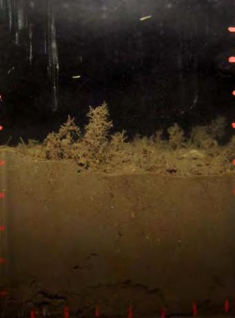
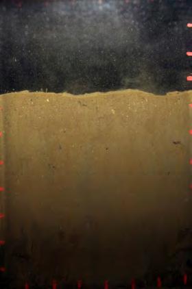
8 Sediment Profile Imagery (SPI) Camera Images collect vertical section of the seabed and examples of the parameter that are measured can be seen below: a) b) c) d) e) Birchenough et al (2012a) Ecological Indicators, Birchenough et al. (2012b)Biogeochemistry, Birchenough et al. (2006) Journal of Marine Systems. Figure: SPI images illustrating the following features: a) gas void, b) polychaete, c) burrows formation, d) pit mound and different sediment types and e) microalgal mat. Advantages of this technique: Fast return of information Effective monitoring tool can cover rapidly large areas of the seabed The information can be easily communicated to non specialists Robust technique for seabed systems SPI survey can be complemented with grab/corers samples
 Banana reef")

9 Methods Transects inside and outside the reef areas with video and SPI Each transect was km= 56 hours =~400 images 5 replicates were collected at each dip Sites: Mingulay, ( m) Banana reef ( m) and Logachev mounds ( m) SPI Allow to hop over the seabed *15-20 seconds SPI *15-20 seconds SPI *15-20 seconds SPI SPI SPI SPI Replicate A Replicate B Replicate C 1.5 2km x x x x x x x x x x x x x x x x x x x x 300m 300m 300m
 sediment water")

10 Image analysis Surface fauna (Lanice conchilega) sediment water interface arpd apparent Redox Discontinuity layer Deep burrowing infauna Burrows


11 Mingulay reef complex


12 Banana Reef BR1 BR4 BR3


13 Logachev Mounds LG1 LG5 LG3 Giant carbonate mounds (bioherms) in the Rockall Trough LG4
14 Study sites Areas Depth (m) Sediment type surface Penetration arpd (cms) burrows Fauna MRC soft muds also stony areas (closer to the reef) small polychaete tubes Good 2 4 cm distinct areas (~2cm) Crinoids (Leptometra sp.), sponges (Mycale macilenta ) and soft corals BR soft muds also stony areas (closer to the reef) Lanice conchilega tubes Good 4 6cm deep burrows (6 8cm) Nephrops norvergicus ** video, tubes and burrowing polychaetes, actinia and stony corals (Caryoplyllia spp.) LM coral fragments, layers of coral rubble rubble, framework/ attached fauna limited (layered deposits) Blue sponge (Hymedesmia paupertas ), squat lobsters (Munida sp.). Coral Madrepora oculata, yellow sponge Mycale macilenta, the white sponge Aphrocallistes bocagei, cup sponges Phakellia sp. and some hydrocorals such as Pliobothrus symmetricus
15 Summary First time that SPI was deployed at these sites This survey has helped to characterise habitats in the vicinity of Lophelia pertusa reefs Fast coverage over large areas This survey will help to scale up experiments Evidence of burrows (bioturbation) and infauna presence (tubes and in sediments) arpd layers varied at the sites Data sets will contribute as baseline information

 2")
16 Acknowledgments Captain Bill Richardson & crew of RRS James Cook V. A. I. Huvenne and C. Alt (NOC ) ICES UKOA for added value awards NERC/DEFRA/DECC Seedcorn Changing Oceans Expedition (DP309 ) )

17 Thank you Questions?
Predicting drivers and distributions of deep-sea ecosystems: A cold-water coral case study
 3rd Science for the Environment Conference Aarhus, Denmark 1-2 October 2015 AARHUS UNIVERSITY Predicting drivers and distributions of deep-sea ecosystems: A cold-water coral case study Christian Mohn,
Report of the ICES/NAFO Joint Working Group on Deep-water Ecology (WGDEC)
") ICES WGDEC REPORT 2017 ICES ADVISORY COMMITTEE ICES CM 2017/ACOM:25 Report of the ICES/NAFO Joint Working Group on Deep-water Ecology (WGDEC) 20 24 March 2017 Copenhagen, Denmark International Council
ICES WGDEC REPORT 2017 ICES ADVISORY COMMITTEE ICES CM 2017/ACOM:25 Report of the ICES/NAFO Joint Working Group on Deep-water Ecology (WGDEC) 20 24 March 2017 Copenhagen, Denmark International Council
Cold-water coral ecosystems from the Moira Mounds (NE Atlantic): the RV Belgica EUROFLEETS CWC Moira cruise
: the RV Belgica EUROFLEETS CWC Moira cruise") Cold-water coral ecosystems from the Moira Mounds (NE Atlantic): the RV Belgica EUROFLEETS CWC Moira cruise S. Spezzaferri 1, G. Gennari 1,, A. Vertino 2, C. Stalder 1, A. Wheeler 3, L. Naudts 4, and the
Cold-water coral ecosystems from the Moira Mounds (NE Atlantic): the RV Belgica EUROFLEETS CWC Moira cruise S. Spezzaferri 1, G. Gennari 1,, A. Vertino 2, C. Stalder 1, A. Wheeler 3, L. Naudts 4, and the
A trans-atlantic assessment and deep-water ecosystem-based spatial management plan for Europe
 A trans-atlantic assessment and deep-water ecosystem-based spatial management plan for Europe This project has received funding from the European Union s Horizon 2020 research and innovation programme
Form 4 of Schedule 5 of the Exclusive Economic Zone and Continental Shelf (Environmental Effects Permitted Activities) Regulations 2013
 Regulations 2013") FORM 4 Permitted activities: Post-activity report Form 4 of Schedule 5 of the Exclusive Economic Zone and Continental Shelf (Environmental Effects Permitted Activities) Regulations 2013 How to use this
FORM 4 Permitted activities: Post-activity report Form 4 of Schedule 5 of the Exclusive Economic Zone and Continental Shelf (Environmental Effects Permitted Activities) Regulations 2013 How to use this
Benthic habitat mapping: a synopsis of methodologies and approaches. Dr. Craig Brown University of Ulster
 Benthic habitat mapping: a synopsis of methodologies and approaches Dr. Craig Brown University of Ulster Technological advances in remote sensing Insitu sampling Improving technology Single beam acoustics/video
Confidence Assessment Scoring System
 Confidence Assessment Scoring System Confidence field Confidence group Confidence question Comments Remote sensing data collection RemoteTechnique Were the techniques used appropriate for the ground type?
Submersible investigation of unconfirmed western Miami Terrace habitat
 Submersible investigation of unconfirmed western Miami Terrace habitat Prepared By: Brian K. Walker, Ph.D. Nova Southeastern University Oceanographic Center 6/08/2015 On June 5, 2015 Nova Southeastern
Picture: Nigel Keeley. SustainAqua. Sustainable aquaculture in the North identifying thresholds, indicators and tools for future growth
 Picture: Nigel Keeley SustainAqua Sustainable aquaculture in the North identifying thresholds, indicators and tools for future growth 4 årigt forskningsråds prosjekt Norway International Raymond Bannister
Role of macrofauna and the impacts of natural and anthropogenic disturbance on sediment biogeochemical processes (Module 3)
") Biogeochemistry, macronutrient and carbon cycling in the benthic layer (BMCC) WP2 Role of macrofauna and the impacts of natural and anthropogenic disturbance on sediment biogeochemical processes (Module
Biogeochemistry, macronutrient and carbon cycling in the benthic layer (BMCC) WP2 Role of macrofauna and the impacts of natural and anthropogenic disturbance on sediment biogeochemical processes (Module
* Corresponding author : Sophie Arnaud-Haond, address :
 1 Deep Sea Research Part II: Topical Studies in Oceanography November 2017, Volume 145, Pages 110-119 http://dx.doi.org/10.1016/j.dsr2.2015.07.013 http://archimer.ifremer.fr/doc/00274/38530/ 2015 Elsevier
Missions from MARS: Marine Autonomous and Robotic Systems - current and future science applications
 Missions from MARS: Marine Autonomous and Robotic Systems - current and future science applications Dr Russell B Wynn (MARS Chief Scientist, Head of NOC Marine Geoscience) Marine Autonomous and Robotic
Arctic Ocean Biology. from the surface to the deep sea
 Arctic Ocean Biology from the surface to the deep sea Christina Bienhold Helmholtz Max Planck Research Group for Deep Sea Ecology and Technology cbienhol@mpi-bremen.de ACCESS Summerschool, Bremen, Germany
INTEGRATED EUROPEAN RESEARCH INTO COLD-WATER CORAL REEFS
 INTEGRATED EUROPEAN RESEARCH INTO COLD-WATER CORAL REEFS BY J. MURRAY ROBERTS AND ANDRÉ FREIWALD ALL THOSE INVOLVED IN MARINE EDUCATION, CONSERVATION, OR RESEARCH will at some stage struggle to convince
Autonomous Platforms for Marine Mapping and Monitoring: A UK Perspective. Dr Russell B Wynn (Head of NOC Marine Geoscience, MARS Chief Scientist)
") Autonomous Platforms for Marine Mapping and Monitoring: A UK Perspective Dr Russell B Wynn (Head of NOC Marine Geoscience, MARS Chief Scientist) Marine mapping and monitoring: an escalating problem. Policy
Autonomous Platforms for Marine Mapping and Monitoring: A UK Perspective Dr Russell B Wynn (Head of NOC Marine Geoscience, MARS Chief Scientist) Marine mapping and monitoring: an escalating problem. Policy
MiningImpact. Environmental Impacts of Deep-Sea Mining. ~17 Mio (funding: ~11 Mio, incl. ship time)
") MiningImpact Environmental Impacts of Deep-Sea Mining Phase 1 Jan 2015 Dec 2017 (25 partners / 11 countries) ~14.5 Mio (funding: ~11.2 Mio, incl. ship time) Phase 2 Aug 2018 Feb 2022 (32 partners / 9 countries
MiningImpact Environmental Impacts of Deep-Sea Mining Phase 1 Jan 2015 Dec 2017 (25 partners / 11 countries) ~14.5 Mio (funding: ~11.2 Mio, incl. ship time) Phase 2 Aug 2018 Feb 2022 (32 partners / 9 countries
Preliminary Report Oceana Important Ecological Areas Seafloor Habitat Expedition Off the Central Oregon Coast. November 1, 2013
 Preliminary Report Oceana Important Ecological Areas Seafloor Habitat Expedition Off the Central Oregon Coast Prepared by: Geoff Shester 1, Ben Enticknap 2, Matthias Gorny 3, and Jason Adelaars 4 November
MPAs - do we need them?
 MPAs - do we need them? Thomas Peschak We all want healthy oceans We all want healthy oceans Our Natural Heritage conserved for future generations We all want healthy oceans To enjoy our sea and the economic
National Marine Sanctuary Program
 National Marine Sanctuary Program NMSP/USGS Joint Seabed Mapping Initiative: September 2004 AA National Ocean Service National Marine Sanctuaries Interim Report September 2004 Background: Since 2002,
ICES Journal of Marine Science
 ICES Journal of Marine Science ICES Journal of Marine Science (2013), 70(3), 511 522. doi:10.1093/icesjms/fss195 Ross D. Bullimore, Nicola L. Foster, and Kerry L. Howell* School of Marine Science and Engineering,
Wilson Bay Sediment Profile Imaging: 1. Instrument Test
 Environment Waikato Technical Report 2006/09 Wilson Bay Sediment Profile Imaging: 1. Instrument Test Prepared by: Kay C. Vopel, Greig Funnell (National Institute of Water & Atmospheric Research Ltd) For:
Carte des peuplements benthiques des substrats meubles de la baie de Saint-Brieuc (Source Thouzeau G., Hamon D., 1992) - Echelle 1/ Score sheet
 - Echelle 1/ Score sheet") 16/07/2010 Carte des peuplements benthiques des substrats meubles de la baie de Saint-Brieuc (Source Thouzeau G., Hamon D., 1992) - Echelle 1/100000 sheet sensing? How good is the ground-truthing? How
16/07/2010 Carte des peuplements benthiques des substrats meubles de la baie de Saint-Brieuc (Source Thouzeau G., Hamon D., 1992) - Echelle 1/100000 sheet sensing? How good is the ground-truthing? How
The Teak-Samaan-Poui marine ecosystem mapping study
 The Teak-Samaan-Poui marine ecosystem mapping study Teak-Samaan-Poui (TSP) Offshore Oil and Gas Production Block operated by Repsol E&P T&T Limited, Trinidad & Tobago Identification of the relevant tip(s)
Eishort 2. Loch Eishort, Isle of Skye. Seabed Video Survey
 Eishort 2 Loch Eishort, Isle of Skye Seabed Video Survey Copyright Hjaltland Seafarms Ltd. All rights reserved. The copyright of this document rests with Hjaltland Seafarms Ltd; no citation from it, in
SEABED MORPHOLOGY OFF SOUTHERN LONG ISLAND: STUDIES OF ARTIFICIAL REEFS AND IMPLICATIONS FOR WIND FARMS. Juliet Kinney & Roger D.
 SEABED MORPHOLOGY OFF SOUTHERN LONG ISLAND: STUDIES OF ARTIFICIAL REEFS AND IMPLICATIONS FOR WIND FARMS Juliet Kinney & Roger D. Flood Marine Sciences Research Center, Stony Brook University Stony Brook,
MAINTENANCE DREDGE BENTHIC ASSESSMENT SUNSET POINT FARM LLC LONG POINT KEY MONROE COUNTY, FLORIDA. Prepared by:
 MAINTENANCE DREDGE BENTHIC ASSESSMENT SUNSET POINT FARM LLC LONG POINT KEY MONROE COUNTY, FLORIDA Prepared by: December 11, 2016 INTRODUCTION The owners of the Sunset Point Farms LLC, located on the northern
Marine Life. and Ecology. 2. From phytoplanktons to invertebates
 Marine Life and Ecology 2. From phytoplanktons to invertebates Virtually all primary productivity on land comes from large seaweeds such as these do exist, but they need shallow water where Sunlight is
Ecological mapping using satellite imagery: an Abu Dhabi case study Middle East Geospatial Forum 16 th February 2015
 Ecological mapping using satellite imagery: an Abu Dhabi case study Middle East Geospatial Forum 16 th February 2015 Richard Flemmings rf@proteusgeo.com About Proteus Formed in UAE 2011 We specialise in
Porcupine/Celtic Observatory Atlantic Ocean
 The Porcupine Seabight and Abyssal Plain area has been an important area for biogeochemical flux studies in the past but is also a very productive fisheries and oil-gas exploration area. It is a stable
MiningImpact. Ecological Aspects of Deep-Sea Mining. Life time 1 January December 2017 Budget ~9.5 Mio (funding: ~6.
 MiningImpact Ecological Aspects of Deep-Sea Mining Partners 25 institutes from 11 European countries Coordinator: Matthias Haeckel, GEOMAR Life time 1 January 2015 31 December 2017 Budget ~9.5 Mio (funding:
Status of Exposed Coral Reef and Threatened Mollusk Associates in Pag-asa Island, Kalayaan Island Group, Philippines Jeric B.
 Status of Exposed Coral Reef and Threatened Mollusk Associates in Pag-asa Island, Kalayaan Island Group, Philippines Jeric B. Gozalez MS Marine Biology CFAS-WPU Introduction Introduction Kalayaan Island
Final Survey/Data Report
 US ARMY CORPS OF ENGINEERS New England District Contract No. DACW33-03-D-004 Delivery Order No. 05 November 2004 Final Survey/Data Report Boston Harbor Deep Draft Navigation Improvement Project Biological
Cold-Water Corals. Preliminary observations on the dynamic reef environment. Oceanography Vol. 22, No.1. By Marc Lavaleye, Gerard Duineveld,
 HERMES SPECIAL ISSUE FEATURE Cold-Water Corals on the Tisler Reef Preliminary observations on the dynamic reef environment 76 By Marc Lavaleye, Gerard Duineveld, Tomas Lundälv, Martin White, Damien Guihen,
Chapter 7 Benthic deep-sea carbonates: reefs and seeps
 Chapter 7 Benthic deep-sea carbonates: reefs and seeps Carbonates are formed across most latitudes and they are not restricted to shallow water but are also found in all but the deepest abyssal and hadal
Food for thoughts. Jon Davies MESH Project Coordinator
 Food for thoughts Jon Davies MESH Project Coordinator You are not alone.. There is someone out there.. Habmap UKSeaMap MESH Why is he here? Introduce the MESH Project, give a brief overview of other marine
FK day Post Cruise Report
 FK190106 30-day Post Cruise Report 1. Ship name: Falkor 2. Cruise Dates - Day Departed: 1/6/2019 3. Cruise Dates - Day Returned: 1/26/2019 4. Cruise Number: FK190106 5. Departure Port: Puntarenas, Costa
Biological survey of species diversity of sea grass beds in selected sites of southern Sri-Lanka.
 Biological survey of species diversity of sea grass beds in selected sites of southern Sri-Lanka. Hikkaduwa,Weligama,Polhena. Harishcandra K.A.D.A.T FS/2006/010 Introduction. 1.What are Sea grasses? 2.Distribution
December 23 rd, 2018 Sample Current Affairs
 December 23 rd, 2018 Sample Current Affairs 1. The coral reef cover in Lakshadweep has shrunk by as much as 40% in just 18 years Why the coral reefs in Lakshadweep are being eroded so fast? How do climate
Trawl-mounted video camera observations of snow crab interaction with footgear
 Trawl-mounted video camera observations of snow crab interaction with footgear Truong Nguyen 1, Paul Winger 1, George Legge 1, Earl Dawe 2, and Darrell Mullowney 2 1 Fisheries and Marine Institute, Memorial
Marine Farming Site North Kilbrannan North Kilbrannan Video Survey March 2017
 Marine Farming Site North Kilbrannan North Kilbrannan Video Survey March 2017 MARINE HARVEST ( SCOTLAND) LIMITED MARCH 2018 Registered in Scotland No. 138843 Registered Office, 1st Floor, Admiralty Park
Report of the Joint ICES/NAFO Working Group on Deep-water Ecology (WGDEC)
") ICES WGDEC REPORT 2016 ICES ADVISORY COMMITTEE ICES CM 2016/ACOM:28 REF. WGMHM, ACOM Report of the Joint ICES/NAFO Working Group on Deep-water Ecology (WGDEC) 15 19 February 2016 Copenhagen, Denmark International
ICES WGDEC REPORT 2016 ICES ADVISORY COMMITTEE ICES CM 2016/ACOM:28 REF. WGMHM, ACOM Report of the Joint ICES/NAFO Working Group on Deep-water Ecology (WGDEC) 15 19 February 2016 Copenhagen, Denmark International
Factors affecting the large scale distribution of deep sea corals and sponges in the Alaskan ecosystems of the North Pacific Ocean
 Factors affecting the large scale distribution of deep sea corals and sponges in the Alaskan ecosystems of the North Pacific Ocean Chris Rooper, Rachel Wilborn, and Pamela Goddard Alaska Fisheries Science
CEND8/12 Cruise Report. RV Cefas Endeavour Cruise Staff. Part A: Part B: Part C: Anna Sypniewska-Huk (Cefas-Marine Chemist)
") CEND8/12 Cruise Report RV Cefas Endeavour Cruise 8 2012 Staff Part A: Dr. Sue Ware (Cefas-Marine Ecologist) Bill Meadows (Cefas-Marine Surveyor) Sally Songer (Cefas-Marine Ecologist) Gary Burt (Cefas-Marine
CEND8/12 Cruise Report RV Cefas Endeavour Cruise 8 2012 Staff Part A: Dr. Sue Ware (Cefas-Marine Ecologist) Bill Meadows (Cefas-Marine Surveyor) Sally Songer (Cefas-Marine Ecologist) Gary Burt (Cefas-Marine
ARTIFICIAL REEFS FOR MITIGATION
 ARTIFICIAL REEFS FOR MITIGATION A Brief Summary Pat Quinn Environmental Planning and Community Resilience Division Types of Damage to Coral Reefs Anchor damage Beach nourishment Pipelines and cable Vessel
Mapping of marine habitats in shallow coastal areas in Denmark
 6 th Workshop Seabed Acoustics, Rostock, November 14/15, 2013 P11-1 Mapping of marine habitats in shallow coastal areas in Denmark Dr. Zyad Al-Hamdani Geological Survey of Denmark and Greenland - GEUS
Biological long-term experiments in 2500 m water depth at the LTER observatory HAUSGARTEN
 Biological long-term experiments in 2500 m water depth at the LTER observatory HAUSGARTEN T. Soltwedel, C. Hasemann, M. Jacob, I. Schewe Alfred-Wegener-Institut Helmholtz-Zentrum für Polar- und Meeresforschung
Abstract. Keywords: blue ling, GIS, marine protection areas, spatial management. 1. Introduction. P. Posen, P. Large and J. Lee
 Estimating uncertainty in deriving spatial distribution of blue ling landings from vessel monitoring system (VMS) data and implications for delineating marine protection boundaries to the northwest of
FINAL SUMMARY REPORT Summary of the Pre- and Post-Construction Seafloor Mapping and Benthic Biology Survey Results
 FINAL SUMMARY REPORT Summary of the - and -Construction Seafloor Mapping and Benthic Biology Survey Results Long Island Replacement Cable Project January 2007 through June 2010 Submitted by: The Connecticut
Understanding the impacts of deep-sea mining on the marine environment
 Understanding the impacts of deep-sea mining on the marine environment Matthias Haeckel GEOMAR Helmholtz Centre for Ocean Research Kiel Science-Policy Workshop Knowledge-Based Governance of Deep-Sea Resources
Disposal Area Monitoring System DAMOS
 Data Summary Report: New London Disposal Site and Vicinity Sediment-Profile and Plan-View Imaging Survey September 2014 Disposal Area Monitoring System DAMOS Data Summary Report 2014-01 March 2015 This
Aarno Kotilainen, The Geological Survey of Finland Anu Reijonen, The Geological Survey of Finland. Open
 Title BALANCE Cruise Report: The Archipelago Sea, 18/7 18/8 2006 BALANCE Interim Report No. 6 Editors Aarno Kotilainen, The Geological Survey of Finland Anu Reijonen, The Geological Survey of Finland Date
AND REGIONAL PROJECTS
 NAIROBI CONVENTION: The Convention for the Protection, Management and Development of the Marine and Coastal Environment of the Western Indian Ocean Nairobi Convention a) Legal framework that has mandate
The environmental effects of seabed mining: aspects of the New Zealand experience
 The environmental effects of seabed mining: aspects of the New Zealand experience Malcolm Clark, Ashley Rowden, Geoffroy Lamarche, Alison MacDiarmid NIWA, Wellington, New Zealand 36 th Annual Conference
ALKOR 346: First IFM-GEOMAR - HYPOX expedition to the Gotland Basin underway.
 ALKOR 346: First IFM-GEOMAR - HYPOX expedition to the Gotland Basin underway. From 18. Sept to 6 Oct. R/V ALKOR is working in the eastern Gotland Basin (central Baltic Sea.). The cruise led by R. Olaf
Peregrino Environmental Monitoring of Calcareous Algae PEMCA
 Peregrino Environmental Monitoring of Calcareous Algae PEMCA Agenda Presentation Introduction and Background Carachteristics Objectives Partners Results and Discussion Conclusions Contributions from the
Knowledge and data gaps on the Rio Grande Rise, South Atlantic Ocean benthic and pelagic ecosystems
 Workshop Towards the development of a strategic Environmental Management Plan for deep seabed mineral exploration and exploitation in the Atlantic basin (SEMPIA) 1-3 June 2015, Horta, Azores, Portugal
SCONSER QUARRY BASELINE VIDEO SURVE Y JANUARY 2017
 SCONSER QUARRY BASELINE VIDEO SURVE Y JANUARY 2017 Registered in Scotland No. 138843 Registered Office, 1st Floor, Admiralty Park Admiralty Road, Rosyth, Fife KY11 2YW Stob Ban House Glen Nevis Business
APPENDIX A. Study Team Member Profiles
 APPENDIX A Study Team Member Profiles APPENDIX A Eugene Lee, M.Sc. 28) was an AMEC Senior environmental/aquatic biologist/project manager with 23 years consulting experience. Mr. Lee has extensive experience
FRontiers in Arctic marine Monitoring: The FRAM Ocean Observing System
 FRontiers in Arctic marine Monitoring: The FRAM Ocean Observing System Thomas Soltwedel Alfred-Wegener-Institute Helmholtz-Center for Polar and Marine Research Arctic Frontiers 2017 Svalbard Symposium
Protecting the ocean s final frontiers the high seas and deep ocean. Callum Roberts University of York
 Protecting the ocean s final frontiers the high seas and deep ocean Callum Roberts University of York The high seas = 61% of the oceans and 43% of the surface of the Earth Courtesy of NASA Goddard Space
A B C D E F G H I J K L M N O
 A B C P Q D E F R S G H I T U J K L V W M N O Supplemental Figure 1. A-F: Continental margin sediments from the Kaikoura Canyon (reprinted with permission from de Leo et al. 2010); G-O: Chile margin (reprinted
Leibniz Institute for Baltic Sea Research Warnemünde (Germany)
") Leibniz Institute for Baltic Sea Research Warnemünde (Germany) C r u i s e R e p o r t r/v "Poseidon" Cruise No. P 475 This report based on preliminary data and results Institut für Ostseeforschung Warnemünde
Leibniz Institute for Baltic Sea Research Warnemünde (Germany) C r u i s e R e p o r t r/v "Poseidon" Cruise No. P 475 This report based on preliminary data and results Institut für Ostseeforschung Warnemünde
Ocean acidification in NZ offshore waters
 Ocean acidification in NZ offshore waters Cliff Law NIWA Review susceptible groups in NZ offshore waters Examples from international research of responses Identify potential impacts in the NZ EEZ Plankton
RV Southern Surveyor. program. voyagesummaryss05/2005
 2005 RV Southern Surveyor program voyagesummaryss05/2005 SS05/2005 Identifying potential natural hydrocarbon Seeps and petroleum resources, including sea floor mapping and classification of Australia s
Three Mile Reef, Bream Bay: A Photographic Survey
 Three Mile Reef, Bream Bay: A Photographic Survey 1 June 2016 2 Cover Photo: Scenes from Three Mile Reef For: Report by: Chancery Green on behalf of the Refining New Zealand V.C. Kerr B.Sc., Roger Grace
CLAM DREDGE FRAMEWORK ADJUSTMENT
 New England Fishery Management Council 50 WATER STREET NEWBURYPORT, MASSACHUSETTS 01950 PHONE 978 465 0492 FAX 978 465 3116 John F. Quinn, J.D., Ph.D., Chairman Thomas A. Nies, Executive Director CLAM
4. Suspension Feeders. Benthic Boundary Layers
 4. Suspension Feeders Benthic Boundary layers Feeding Types Active Passive Facultative Feeding Mechanisms and Structures Altering Flow Dr Rhian G. Waller 14 th April 2010 Reading: Wildish & Kristmanson,
Weekly summary of Tropic101x as posted by student Lucia_Agudelo
 Weekly summary of Tropic101x as posted by student Lucia_Agudelo With minor grammatical and content edits by Tropic101x team Summary of Week 6 FIELD METHODS LECTURE 6.1.1 Being able to measure the distribution,
Short Cruise Report RV METEOR Cruise M122. Walvis Bay Walvis Bay Chief Scientist: Dierk Hebbeln Captain: Rainer Hammacher
 Prof. Dr. Dierk Hebbeln MARUM Center for Marine Environmental Sciences University of Bremen Leobener Straße 28359 Bremen Germany Tel.: +49 421 21865650 Fax: +49 421 21865654 email: dhebbeln@marum.de Short
Managing Impacts of Deep-seA resource exploitation - the MIDAS project. Phil Weaver Seascape Consultants Romsey, UK
 Managing Impacts of Deep-seA resource exploitation - the MIDAS project Phil Weaver Seascape Consultants Romsey, UK Seas at Risk workshop, Brussels 5 th November 2014 Total number of ISA Contractors Number
May 07- June 02 John McDonough: Ocean Exploration An Investigation of the Deep Coral Lophellia pertusa in the Northern Gulf of Mexico
 ALVIN REPORTS 2006 May 07- June 02 John McDonough: Ocean Exploration An Investigation of the Deep Coral Lophellia pertusa in the Northern Gulf of Mexico Quantifying Elemental Fluxes and Fluid Origins at
A PRACTICAL EXAMPLE OF MAPPING IN ORDER TO SELECT AREAS CLOSED TO PROTECT COLD-WATER CORALS IN THE HIGH- SEAS (HATTON BANK, ICES VIb1 & XIIb) ABSTRACT
 ABSTRACT") Theme Session on Sediment biota interactions and mapping marine habitats (G) Not to be cited without prior reference to the authors ICES CM 2008/G:01 A PRACTICAL EXAMPLE OF MAPPING IN ORDER TO SELECT AREAS
Theme Session on Sediment biota interactions and mapping marine habitats (G) Not to be cited without prior reference to the authors ICES CM 2008/G:01 A PRACTICAL EXAMPLE OF MAPPING IN ORDER TO SELECT AREAS
Marine biologists have identified over 250,000 marine species. This number is constantly increasing as new organisms are discovered.
 A wide variety of organisms inhabit the marine environment. These organisms range in size from microscopic bacteria and algae to the largest organisms alive today blue whales, which are as long as three
Cold-water corals have been known
 Reefs of the Deep: The Biology and Geology of Cold-Water Coral Ecosystems J. Murray Roberts, 1 Andrew J. Wheeler, 2 André Freiwald 3 Coral reefs are generally associated with shallow tropical seas; however,
Nova Scotia Department of Fisheries and Aquaculture. Environmental Monitoring Program Summary
 Nova Scotia Department of Fisheries and Aquaculture Environmental Monitoring Program Summary 2015 Table of Contents 1 Environmental Monitoring Program Overview... 1 2 2015 EMP... 5 2.1 Level I... 5 2.1.1
Courtesy of John Mitchell
 Shrimp trawl fisheries Marine fish stocks are under increasing threat from a range of spatially based problems that might be natural or involve socio-economic factors. To best manage spatial problems,
Sister Sanctuaries: Linking the Science and Management of Coral Reefs in Cuba and the U.S.
 Sister Sanctuaries: Linking the Science and Management of Coral Reefs in Cuba and the U.S. Memorandum of Understanding on Cooperation in the Conservation and Management of Marine Protected Areas Seventh
2013 Sediment Profile Imaging Surveys
 2013 Sediment Profile Imaging Surveys Commencement Bay and Elliott Bay DMMP Sites Final October 21, 2013 NewFields 115 2 nd Ave N, Suite 100 Edmonds, WA 98020 Cover photo compliments of Charlie Eaton Photo
Why do we need a global framework for MPAs in ABNJ? Kristina M. Gjerde IUCN High Seas Policy Advisor
 Why do we need a global framework for MPAs in ABNJ? Kristina M. Gjerde IUCN High Seas Policy Advisor kgjerde@eip.com.pl 40% ocean heavily affected by humans (c) Halpern et al. 2008. Scientists found that
Assessment of Benthic Coral Reef Organisms in Dry Tortugas National Park and the Western Florida Keys National Marine Sanctuary
 Assessment of Benthic Coral Reef Organisms in Dry Tortugas National Park and the Western Florida Keys National Marine Sanctuary 2008 Quick Look Report and Data Summary December 2009 Steven L. Miller 1,
Kamburu Faru Boatu Urunu Faru Velaa Faru Dhakandhoo Mendhoo Funadhoo
 IG Working Group REEForm Reef and reef landform responses to environmental and climatic change Report from Research Expedition, Maldives, 29 th June to 13 th July 2011 Participants: hris Perry (Manchester
Scottish MPA Project Data confidence assessment SHIANT EAST BANK MPA PROPOSAL
 Scottish MPA Project Data confidence assessment SHIANT EAST BANK MPA PROPOSAL Document version control Version Date Author Reason / Comments Version 1 29/01/2014 Laura Clark Revised MPA proposal format,
Marine benthic habitats of the George V Land shelf, Antarctica
 Marine benthic habitats of the George V Land shelf, Antarctica Linking geophysical and biological data in a polar environment Robin J. Beaman Project acknowledgements Geoscience Australia seismic profiles,
Detailed mapping of seabed topography,
 MAREANO program Detailed mapping of seabed topography, sediments, bottom fauna and pollutants in Norwegian waters HYDROGRAPHIC DATA FOR THE BENEFIT OF SOCIETY MAREANO program - Detailed mapping of seabed
Research Background: Researcher Sam Bond taking Sediment Elevation Table (SET) measurements in the marsh. A view of salt marsh hay growing in a marsh
 measurements in the marsh. A view of salt marsh hay growing in a marsh") Name Keeping up with the sea level Featured scientist: Anne Giblin from the Marine Biological Laboratory and the Plum Island Ecosystems Long-Term Ecological Research site Research Background: Salt marshes
Name Keeping up with the sea level Featured scientist: Anne Giblin from the Marine Biological Laboratory and the Plum Island Ecosystems Long-Term Ecological Research site Research Background: Salt marshes
MiningImpact. Environmental Impacts & Risks of Deep-Sea Mining
 MiningImpact Environmental Impacts & Risks of Deep-Sea Mining Phase 1 Jan 2015 Dec 2017 (25 partners / 11 countries) ~14.5 Mio (funding: ~11.2 Mio, incl. ship time) Phase 2 Aug 2018 Feb 2022 (30 partners
Impacts of Deep Sea Mining. Phil Weaver Seascape Consultants Romsey, UK
 Impacts of Deep Sea Mining Phil Weaver Seascape Consultants Romsey, UK phil.weaver@seascapeconsultants.co.uk MIN_GUIDE annual mee?ng, Brussels, 13-14 December, 2017 Three types of Deep Sea Mineral Mn-Nodules
GLASS SPONGES AND SPONGE REEFS IN BRITISH COLUMBIA WATERS
 1 GLASS SPONGES AND SPONGE REEFS IN BRITISH COLUMBIA WATERS By Dr. Sally Leys, Department of Biological Sciences, University of Alberta What are glass sponges? Sponges are normally thought of as soft and
Evolution and Life in the Ocean
 Characteristics of All Living Things Contain matter in a highly organized state Capture, store and transmit energy; all organisms require energy Capable of reproduction Change through time and adapt to
Workshop background and objectives
 Cobalt crusts and the diversity and distribution patterns of seamount faunas Workshop background and objectives Tony Koslow March 2006 CSIRO Marine and Atmospheric Research Perth, Australia www.csiro.au
High-resolution bottom albedo images and benthic habitat classification to develop baseline management tools in Natural Reserves
 High-resolution bottom albedo images and benthic habitat classification to develop baseline management tools in Natural Reserves *William J. Hernandez, Ph.D. and Roy A. Armstrong, Ph.D. *Post-Doctoral
6 th Meeting of the Scientific Committee Puerto Varas, Chile, 9-14 September 2018
 6 th Meeting of the Scientific Committee Puerto Varas, Chile, 9-14 September 2018 SC6-DW11 Methods for designing spatial management areas using outputs from Zonation software and other spatial data Martin
coastalmanagement Wriggle Porirua Harbour Intertidal Sediment Monitoring 2010/11
 coastalmanagement Porirua Harbour Intertidal Sediment Monitoring 2010/11 Prepared for Greater Wellington Regional Council June 2011 Porirua Harbour Onepoto Arm - lower estuary. Porirua Harbour Intertidal
Steve W. Ross* UNC-Wilmington, Center for Marine Science 5600 Marvin Moss Ln. Wilmington, NC 28409
 REVIEW OF DISTRIBUTION, HABITATS, AND ASSOCIATED FAUNA OF DEEP WATER CORAL REEFS ON THE SOUTHEASTERN UNITED STATES CONTINENTAL SLOPE (NORTH CAROLINA TO CAPE CANAVERAL, FL) Steve W. Ross* UNC-Wilmington,
Deep sea floor By. The structures and features of ocean basin are summarized in Fig. 1. Ocean basin
 Deep sea floor By Sufia Zaman 1, Tanmay Ray Chaudhuri 2, Prosenjit Pramanick 2 and Abhijit Mitra 1 1 Department of Marine Science, University of Calcutta, 35, B. C. Road, Kolkata-700 019, India. 2 Department
Vision: The National Oceanography Centre will, by 2015, be recognised as the world-leading Centre for integrated ocean sciences and technology".
 National Oceanography Centre from coast to deep ocean Waterfront Campus, Southampton Vision: Joseph Proudman Building, Liverpool The National Oceanography Centre will, by 2015, be recognised as the world-leading
The Role of Seafloor Characterization and Benthic Habitat Mapping in Dredged Material Management: A Review
 J. of Marine Env. Eng., Vol. 7, pp. 185-215 2004 Old City Publishing, Inc. Reprints available directly from the publisher Published by license under the OCP Science imprint, Photocopying permitted by license
Field test of a novel, low-cost, scanner-based sediment profile imaging camera
 LIMNOLOGY and OCEANOGRAPHY: METHODS Limnol. Oceanogr.: Methods 4, 2006, 30 37 2006, by the American Society of Limnology and Oceanography, Inc. Field test of a novel, low-cost, scanner-based sediment profile
STEREO-VIDEO SURVEYS OF DEEP WATER HABITATS
 STEREO-VIDEO SURVEYS OF DEEP WATER HABITATS M. R. Shortis 1, J. W. Seager 2, A. Williams 3, and B. A. Barker 3 1 Science, Engineering and Technology Portfolio, RMIT University, GPO Box 2476V, Melbourne
1980/1981. R W Grigg
 TECHNICAL REPORT NO. 14 11 May 1981 SPECIES IDENTIFICATION AND ASSESSMENT OF CCOP/SOPAC PRECIOUS CORAL COLLECTIONS 1980/1981 by R W Grigg Prepared for: As a contribution by: COMMITTEE FOR CO-ORDINATION