Geospatial dynamics of Northwest. fisheries in the 1990s and 2000s: environmental and trophic impacts
|
|
|
- Lesley Robbins
- 6 years ago
- Views:
Transcription


1 Geospatial dynamics of Northwest Atlantic ti cod and crustacean fisheries in the 1990s and 2000s: environmental and trophic impacts Matthew J.S. WINDLE 1, George A. ROSE 2, Rodolphe DEVILLERS 3, and Marie-Josée FORTIN 4 1 PhD Candidate, Memorial University, Canada 2 Professor, Fisheries Conservation Group, Memorial University 3 Assistant Professor, Department of Geography, Memorial University 4 Professor, Department of Ecology and Evolutionary Biology, University of Toronto


2 Collapse of the Northern Cod Rose, 2007 DFO SSR 2004/011
3 Fall 1983
4 Fall 1984
5 Fall 1985
6 Fall 1986
7 Fall 1987
8 Fall 1989
9 Fall 1990
10 Fall 1991
11 Fall 1992
12 Fall 1993
13 Fall 1994
14 Fall 1995

 DFO")
15 Northern Shrimp (Pandalis borealis) DFO SSR Report 2004/022

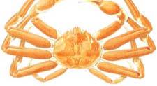


16 Snow Crab (Chionoecetes opilio) DFO SSR 2003/021


17 GeoCod Project Study Area Environmental Data Temperature Salinity Remote Sensing > 300 GB! Fisheries Data Scientific Surveys Industry Data Four Species > 800,000 records!

 regression and Geographically")
18 Study Objectives 1. To model the spatial relationships between cod biomass and environmental and trophic variables 2. To compare Odi Ordinary Least ts Squares (OLS) regression and Geographically Weighted Regression (GWR) model performance 3. To investigate spatial non-stationarity of the regression parameters a e within the study area
 [log(kg)] g)] snow crab [log(kg)] northern shrimp [log(kg)] depth (m) bottom temperature ( C) bottom salinity (ppt) slope (degrees) distance from shore")
19 Data Description Source: Canadian Department of Fisheries and Oceans Stratified Random Bottom Trawl Surveys (Newfoundland Region) Timeline: Variables: Atlantic cod (dependent) [log(kg)] g)] snow crab [log(kg)] northern shrimp [log(kg)] depth (m) bottom temperature ( C) bottom salinity (ppt) slope (degrees) distance from shore (m)


20 Newfoundland Fall Multispecies Trawl Surveys ( ) Labrador Newfoundland
21 Regression Models Ordinary Least Squares (OLS) γ β + β x β + ε = x p p Geographically Weighted Regression (GWR) γ = β μ, ν ) + β ( μ, ν ) x β ( μ, ν ) x + ε 0 ( p p ε Coordinates of Samples Model Type: Gaussian Bandwidth Selection: Akaike Information Criterion (AIC) Kernel Type: Fixed, Bi-Square Software: GWR 3.0 for regression (Fotheringham et al.), ArcGIS (v. 9.2) for mapping
22 Pre-Regression Data Analysis High correlation between independent variables makes it difficult to identify the individual contribution of each variable Collinearity it Diagnostics: Correlation matrix Helps identify pairwise collinearity VIF (Variance Inflation Factor) Collinearity is present when VIF for at least one independent variable is large (>5 or >10) Variables retained: Bottom salinity, distance from shore, crab and shrimp
23 Adjusted R 2 Comparison 06 0,6 0,5 Ad djusted R2 0,4 0,3 0,2 0, OLS GWR
 R 2")


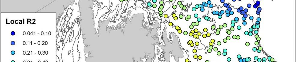

24 Local (GWR) R 2 Fall 1995 Survey Fall 2000 Survey
25 Global Coefficient Estimates 0,2 0,1 0-0,1-0,2 02-0,3-0,4 04-0, B_SAL Distance Log_Crab Log_Shrimp Salinity and Shrimp significant predictors for cod biomass
26 Model Performance Comparison Akaike Information Criterion (AIC) Scores The lower the AIC, the closer the approximation of the model to reality AIC values that differ by more than 3 units considered significantly different AIC Sco ore OLS GWR
27 Model Performance Comparison Improvement of GWR over OLS model assessed using F-test F P value < Significant improvement in all years!


")
28 Observed Cod Weight (Fall 1995) OLS Predicted (Fall 1995) GWR Predicted (Fall 1995)

")


29 Model Residuals Global (OLS) residuals - Fall 1995 Local (GWR) residuals - Fall 1995
30 Spatial Autocorrelation of Residuals Global Moran s I (ArcMap) OLS Residuals GWR Residuals Fall 1995
31 Spatial Non-Stationarity of Parameter Estimates with GWR Spatial non-stationarity of GWR coefficients tested with Monte Carlo significance test All variables consistently show significant spatial non- stationarity in relationship with cod biomass Examples (maps)

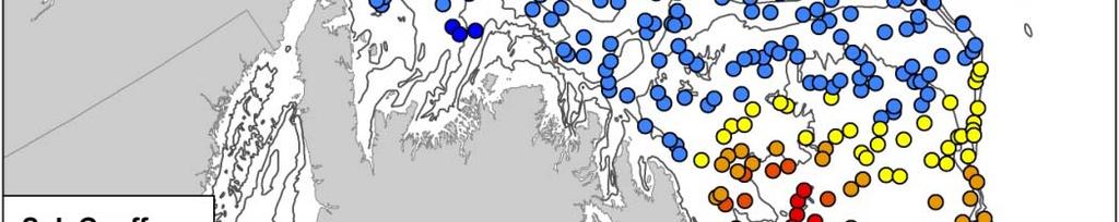
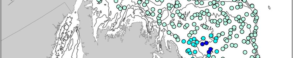
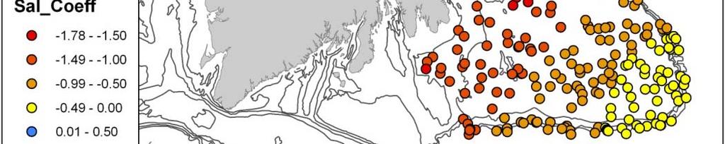

32 Spatial Non-Stationarity of Parameter Estimates with GWR Salinity - Fall 1995 Shrimp - Fall 1995


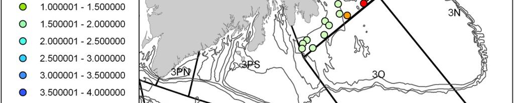
33 Spatial Non-Stationarity in NAFO Management Divisions Salinity - Fall 1995 NAFO Division 3K Shrimp - Fall 1995 NAFO Division 3L
34 Conclusions Global regression models not completely satisfactory for fisheries analyses at large scales Local spatial regression models relatively new in fisheries research, can better explore spatial variability of fisheries data GWR increased model fit and precision i in current study Additional 20% to 45% of variation explained over OLS Large reduction in prediction error of GWR residuals GWR revealed non-stationarity of relationship between cod and environmental/trophic variables within study area Next steps Time-lagged analysis


35 Acknowledgements GEOIDE Network Canadian Center for Fisheries Innovations Fisheries and Oceans Canada Fisheries and Aquaculture Newfoundland World Wildlife Fund CIDCO St. Lawrence Observatory IFREMER
 Dr.")
36 GeoCod Team Researchers Students Dr. Rodolphe Devillers Matthew Windle (PhD) Project Leader Valérie Carette (MSc) Dr. Mir Abolfazl Mostafavi Jonathan Ruppert (BSc) Deputy-leader Dr. Marie-Josée Fortin Dr. George Rose International Collaborators Dr. Stewart Fotheringham (National University of Ireland) Dr. Geoff Meaden (Canterbury Christ Church University) Krista Jones (BSc) René Enguehard (BSc) Steve Hill (BSc) Brad Durdle (BSc) Jennifer Guy (BSc) Research Professionals Philippe LeBlanc Randy McVeigh Memorial University University of Toronto Université Laval
37 For more information visit the GeoCod website:
38 Obrigado! Thank you!
Exploratory Spatial Data Analysis (ESDA)
") Exploratory Spatial Data Analysis (ESDA) VANGHR s method of ESDA follows a typical geospatial framework of selecting variables, exploring spatial patterns, and regression analysis. The primary software
Exploratory Spatial Data Analysis (ESDA) VANGHR s method of ESDA follows a typical geospatial framework of selecting variables, exploring spatial patterns, and regression analysis. The primary software
GeoDa-GWR Results: GeoDa-GWR Output (portion only): Program began at 4/8/2016 4:40:38 PM
: Program began at 4/8/2016 4:40:38 PM") New Mexico Health Insurance Coverage, 2009-2013 Exploratory, Ordinary Least Squares, and Geographically Weighted Regression Using GeoDa-GWR, R, and QGIS Larry Spear 4/13/2016 (Draft) A dataset consisting
New Mexico Health Insurance Coverage, 2009-2013 Exploratory, Ordinary Least Squares, and Geographically Weighted Regression Using GeoDa-GWR, R, and QGIS Larry Spear 4/13/2016 (Draft) A dataset consisting
Statistics: A review. Why statistics?
 Statistics: A review Why statistics? What statistical concepts should we know? Why statistics? To summarize, to explore, to look for relations, to predict What kinds of data exist? Nominal, Ordinal, Interval
A GEOSTATISTICAL APPROACH TO PREDICTING A PHYSICAL VARIABLE THROUGH A CONTINUOUS SURFACE
 Katherine E. Williams University of Denver GEOG3010 Geogrpahic Information Analysis April 28, 2011 A GEOSTATISTICAL APPROACH TO PREDICTING A PHYSICAL VARIABLE THROUGH A CONTINUOUS SURFACE Overview Data
Spatial Variation in Infant Mortality with Geographically Weighted Poisson Regression (GWPR) Approach
 Approach") Spatial Variation in Infant Mortality with Geographically Weighted Poisson Regression (GWPR) Approach Kristina Pestaria Sinaga, Manuntun Hutahaean 2, Petrus Gea 3 1, 2, 3 University of Sumatera Utara,
Spatial Variation in Infant Mortality with Geographically Weighted Poisson Regression (GWPR) Approach Kristina Pestaria Sinaga, Manuntun Hutahaean 2, Petrus Gea 3 1, 2, 3 University of Sumatera Utara,
Modeling Spatial Relationships using Regression Analysis
 Esri International User Conference San Diego, CA Technical Workshops July 2011 Modeling Spatial Relationships using Regression Analysis Lauren M. Scott, PhD Lauren Rosenshein, MS Mark V. Janikas, PhD Answering
Hotspots of Hector s Dolphins On the South Coast
 Hotspots of Hector s Dolphins On the South Coast Judy Rodda 1 and Antoni Moore 1 1 School of Surveying University of Otago, Dunedin, New Zealand Phone: +64 3 479-7585 Fax: +64 3 479-7586 Email: judy.rodda@postgrad.otago.ac.nz
Using Spatial Statistics Social Service Applications Public Safety and Public Health
 Using Spatial Statistics Social Service Applications Public Safety and Public Health Lauren Rosenshein 1 Regression analysis Regression analysis allows you to model, examine, and explore spatial relationships,
APPLICATION OF GEOGRAPHICALLY WEIGHTED REGRESSION ANALYSIS TO LAKE-SEDIMENT DATA FROM AN AREA OF THE CANADIAN SHIELD IN SASKATCHEWAN AND ALBERTA
 APPLICATION OF GEOGRAPHICALLY WEIGHTED REGRESSION ANALYSIS TO LAKE-SEDIMENT DATA FROM AN AREA OF THE CANADIAN SHIELD IN SASKATCHEWAN AND ALBERTA Nadia Yavorskaya 1, Stephen Amor 2 1 450 Bonner Av., Winnipeg,
GIS Analysis: Spatial Statistics for Public Health: Lauren M. Scott, PhD; Mark V. Janikas, PhD
 Some Slides to Go Along with the Demo Hot spot analysis of average age of death Section B DEMO: Mortality Data Analysis 2 Some Slides to Go Along with the Demo Do Economic Factors Alone Explain Early Death?
Modeling Spatial Relationships Using Regression Analysis
 Esri International User Conference San Diego, California Technical Workshops July 24, 2012 Modeling Spatial Relationships Using Regression Analysis Lauren M. Scott, PhD Lauren Rosenshein Bennett, MS Answering
Using Spatial Statistics and Geostatistical Analyst as Educational Tools
 Using Spatial Statistics and Geostatistical Analyst as Educational Tools By Konrad Dramowicz Centre of Geographic Sciences Lawrencetown, Nova Scotia, Canada ESRI User Conference, San Diego, California
Geographically Weighted Regression and Kriging: Alternative Approaches to Interpolation A Stewart Fotheringham
 Geographically Weighted Regression and Kriging: Alternative Approaches to Interpolation A Stewart Fotheringham National Centre for Geocomputation National University of Ireland, Maynooth http://ncg.nuim.ie
A geographically weighted regression
 The Spatial Distribution of Poverty A geographically weighted regression by Introduction Problem How can we explore the spatial distribution of poverty and determine its correlates? This exercise examines
Prospect. February 8, Geographically Weighted Analysis - Review and. Prospect. Chris Brunsdon. The Basics GWPCA. Conclusion
 bruary 8, 0 Regression (GWR) In a nutshell: A local statistical technique to analyse spatial variations in relationships Global averages of spatial data are not always helpful: climate data health data
A FOSS Web Tool for Spatial Regression Techniques and its Application to Explore Bike Sharing Usage Patterns
 A FOSS Web Tool for Spatial Regression Techniques and its Application to Explore Bike Sharing Usage Patterns MGIS Capstone Proposal Author: Spencer Bell Presentation Outline Background Bike Share Spatial
Towards a better adoption of ISO/TC 211 standards: Courses on international standards in geomatics
 Towards a better adoption of ISO/TC 211 standards: Courses on international standards in geomatics Dr. Thierry Badard Centre for Research in Geomatics (CRG) University Laval, Québec, Canada Thierry.Badard@scg.ulaval.ca
Modeling Spatial Relationships Using Regression Analysis. Lauren M. Scott, PhD Lauren Rosenshein Bennett, MS
 Modeling Spatial Relationships Using Regression Analysis Lauren M. Scott, PhD Lauren Rosenshein Bennett, MS Workshop Overview Answering why? questions Introduce regression analysis - What it is and why
Departamento de Economía Universidad de Chile
 Departamento de Economía Universidad de Chile GRADUATE COURSE SPATIAL ECONOMETRICS November 14, 16, 17, 20 and 21, 2017 Prof. Henk Folmer University of Groningen Objectives The main objective of the course
Knowledge Spillovers, Spatial Dependence, and Regional Economic Growth in U.S. Metropolitan Areas. Up Lim, B.A., M.C.P.
 Knowledge Spillovers, Spatial Dependence, and Regional Economic Growth in U.S. Metropolitan Areas by Up Lim, B.A., M.C.P. DISSERTATION Presented to the Faculty of the Graduate School of The University
Modeling the Ecology of Urban Inequality in Space and Time
 Modeling the Ecology of Urban Inequality in Space and Time Corina Graif PhD Candidate, Department Of Sociology Harvard University Presentation for the Workshop on Spatial and Temporal Modeling, Center
Terms ABBR Definition
 Affect Akaike s Information Criterion AIC Affect is a verb referring to the act of influencing or causing a change in something else (not to be confused with effect) Akaike s Information Criterion (AIC)
EEOS 465 / 627 Environmental Modeling with Raster GIS. David Tenenbaum EEOS 465 / 627 UMass Boston
 EEOS 465 / 627 Environmental Modeling with Raster GIS EEOS 465 / 627 Environmental Modeling with Raster GIS Course Description: This course consists of three parts: In the first four weeks, we will focus
Spatial Planning in Canada s Maritimes Region. Maritimes Region
 Spatial Planning in Canada s Maritimes Region Glen Herbert, Scott Coffen-Smout Smout,, and Tanya Koropatnick Oceans and Coastal Management Division Ecosystem Management Branch Fisheries and Oceans Canada
Introduction. Introduction (Contd.) Market Equilibrium and Spatial Variability in the Value of Housing Attributes. Urban location theory.
 Market Equilibrium and Spatial Variability in the Value of Housing Attributes. Urban location theory.") Forestry, Wildlife, and Fisheries Graduate Seminar Market Equilibrium and Spatial Variability in the Value of Housing Attributes Seung Gyu Kim Wednesday, 12 March 2008 1 Introduction Urban location theory
Forestry, Wildlife, and Fisheries Graduate Seminar Market Equilibrium and Spatial Variability in the Value of Housing Attributes Seung Gyu Kim Wednesday, 12 March 2008 1 Introduction Urban location theory
Geographically weighted regression approach for origin-destination flows
 Geographically weighted regression approach for origin-destination flows Kazuki Tamesue 1 and Morito Tsutsumi 2 1 Graduate School of Information and Engineering, University of Tsukuba 1-1-1 Tennodai, Tsukuba,
Summary of OLS Results - Model Variables
 Summary of OLS Results - Model Variables Variable Coefficient [a] StdError t-statistic Probability [b] Robust_SE Robust_t Robust_Pr [b] VIF [c] Intercept 12.722048 1.710679 7.436839 0.000000* 2.159436
Geographically Weighted Regression as a Statistical Model
 Geographically Weighted Regression as a Statistical Model Chris Brunsdon Stewart Fotheringham Martin Charlton October 6, 2000 Spatial Analysis Research Group Department of Geography University of Newcastle-upon-Tyne
Spatial Regression. 6. Specification Spatial Heterogeneity. Luc Anselin.
 Spatial Regression 6. Specification Spatial Heterogeneity Luc Anselin http://spatial.uchicago.edu 1 homogeneity and heterogeneity spatial regimes spatially varying coefficients spatial random effects 2
Geographically Weighted Regression
 Geographically Weighted Regression Modelling spatially heterogenous processes Martin Charlton National Centre for Geocomputation National University of Ireland Maynooth Outline Introduction Spatial Data
Inference Methods for the Conditional Logistic Regression Model with Longitudinal Data Arising from Animal Habitat Selection Studies
 Inference Methods for the Conditional Logistic Regression Model with Longitudinal Data Arising from Animal Habitat Selection Studies Thierry Duchesne 1 (Thierry.Duchesne@mat.ulaval.ca) with Radu Craiu,
Models for Count and Binary Data. Poisson and Logistic GWR Models. 24/07/2008 GWR Workshop 1
 Models for Count and Binary Data Poisson and Logistic GWR Models 24/07/2008 GWR Workshop 1 Outline I: Modelling counts Poisson regression II: Modelling binary events Logistic Regression III: Poisson Regression
This report details analyses and methodologies used to examine and visualize the spatial and nonspatial
 Analysis Summary: Acute Myocardial Infarction and Social Determinants of Health Acute Myocardial Infarction Study Summary March 2014 Project Summary :: Purpose This report details analyses and methodologies
Spatial Statistics For Real Estate Data 1
 1 Key words: spatial heterogeneity, spatial autocorrelation, spatial statistics, geostatistics, Geographical Information System SUMMARY: The paper presents spatial statistics tools in application to real
Regression Analysis. A statistical procedure used to find relations among a set of variables.
 Regression Analysis A statistical procedure used to find relations among a set of variables. Understanding relations Mapping data enables us to examine (describe) where things occur (e.g., areas where
Explorative Spatial Analysis of Coastal Community Incomes in Setiu Wetlands: Geographically Weighted Regression
 Explorative Spatial Analysis of Coastal Community Incomes in Setiu Wetlands: Geographically Weighted Regression Z. Syerrina 1, A.R. Naeim, L. Muhamad Safiih 3 and Z. Nuredayu 4 1,,3,4 School of Informatics
Mapping Your Educational Research: Putting Spatial Concepts into Practice with GIS. Mark Hogrebe Washington University in St.
 Mapping Your Educational Research: Putting Spatial Concepts into Practice with GIS Mapping Your Educational Research: Putting Spatial Concepts into Practice with GIS Mark Hogrebe Washington University
The United States & Canada. A Regional Study of Anglo America
 A Regional Study of Anglo America Landform Regions of the United States & Canada world leaders in agricultural and industrial production because of... VAST LANDS stretch from the Atlantic Ocean on the
2. Linear regression with multiple regressors
 2. Linear regression with multiple regressors Aim of this section: Introduction of the multiple regression model OLS estimation in multiple regression Measures-of-fit in multiple regression Assumptions
Final Review. Yang Feng. Yang Feng (Columbia University) Final Review 1 / 58
 Final Review 1 / 58") Final Review Yang Feng http://www.stat.columbia.edu/~yangfeng Yang Feng (Columbia University) Final Review 1 / 58 Outline 1 Multiple Linear Regression (Estimation, Inference) 2 Special Topics for Multiple
Final Review Yang Feng http://www.stat.columbia.edu/~yangfeng Yang Feng (Columbia University) Final Review 1 / 58 Outline 1 Multiple Linear Regression (Estimation, Inference) 2 Special Topics for Multiple
Single and multiple linear regression analysis
 Single and multiple linear regression analysis Marike Cockeran 2017 Introduction Outline of the session Simple linear regression analysis SPSS example of simple linear regression analysis Additional topics
Spatial Data Discovery and Support in a Library Setting
 Spatial Data Discovery and Support in a Library Setting Marcel Fortin Map and Data Library University of Toronto Expert Meeting on Spatial Discovery Santa Barbara June 2015 Spatial Communities - U of Toronto
MULTICOLLINEARITY AND VARIANCE INFLATION FACTORS. F. Chiaromonte 1
 MULTICOLLINEARITY AND VARIANCE INFLATION FACTORS F. Chiaromonte 1 Pool of available predictors/terms from them in the data set. Related to model selection, are the questions: What is the relative importance
European Migration to Tilting, Newfoundland
 European Migration to Tilting, Newfoundland Lesson Overview In this lesson, students will learn about historical connections between Tilting, Newfoundland and Labrador, and Ireland. Using the Canadian
Synthesis and Integrated Modeling of Long-term Data Sets to Support Fisheries and Hypoxia Management in the Northern Gulf of Mexico
 Synthesis and Integrated Modeling of Long-term Data Sets to Support Fisheries and Hypoxia Management in the Northern Gulf of Mexico Dan Obenour (Scientific/Hypoxia PI) Kevin Craig (Applications/Fisheries
Running head: GEOGRAPHICALLY WEIGHTED REGRESSION 1. Geographically Weighted Regression. Chelsey-Ann Cu GEOB 479 L2A. University of British Columbia
 Running head: GEOGRAPHICALLY WEIGHTED REGRESSION 1 Geographically Weighted Regression Chelsey-Ann Cu 32482135 GEOB 479 L2A University of British Columbia Dr. Brian Klinkenberg 9 February 2018 GEOGRAPHICALLY
ESRI 2008 Health GIS Conference
 ESRI 2008 Health GIS Conference An Exploration of Geographically Weighted Regression on Spatial Non- Stationarity and Principal Component Extraction of Determinative Information from Robust Datasets A
Trawl-mounted video camera observations of snow crab interaction with footgear
 Trawl-mounted video camera observations of snow crab interaction with footgear Truong Nguyen 1, Paul Winger 1, George Legge 1, Earl Dawe 2, and Darrell Mullowney 2 1 Fisheries and Marine Institute, Memorial
Forecasting Bangladesh's Inflation through Econometric Models
 American Journal of Economics and Business Administration Original Research Paper Forecasting Bangladesh's Inflation through Econometric Models 1,2 Nazmul Islam 1 Department of Humanities, Bangladesh University
Lecture 5: Estimation of time series
 Lecture 5, page 1 Lecture 5: Estimation of time series Outline of lesson 5 (chapter 4) (Extended version of the book): a.) Model formulation Explorative analyses Model formulation b.) Model estimation
Managing Uncertainty in Habitat Suitability Models. Jim Graham and Jake Nelson Oregon State University
 Managing Uncertainty in Habitat Suitability Models Jim Graham and Jake Nelson Oregon State University Habitat Suitability Modeling (HSM) Also known as: Ecological Niche Modeling (ENM) Species Distribution
2004 State of the Ocean: Physical Oceanographic Conditions in the Newfoundland and Labrador Region
 Canadian Science Advisory Secretariat Science Advisory Report 25/18 Research vessel CCGS Teleost 24 State of the Ocean: Physical Oceanographic Conditions in the Newfoundland and Labrador Region Background
Winter Skate Leucoraje ocellata.
 Addendum to COSEWIC 2015 Status Report for the Winter Skate Leucoraje ocellata. 2017 Fisheries and Oceans Canada (DFO) has requested that COSEWIC reconsider the designatable unit (DU) structure for Winter
Spatial Regression Modeling
 Spatial Regression Modeling Paul Voss & Katherine Curtis The Center for Spatially Integrated Social Science Santa Barbara, CA July 12-17, 2009 Day 4 Plan for today Focus on spatial heterogeneity A bit
Spatial Analysis 1. Introduction
 Spatial Analysis 1 Introduction Geo-referenced Data (not any data) x, y coordinates (e.g., lat., long.) ------------------------------------------------------ - Table of Data: Obs. # x y Variables -------------------------------------
Spatial analysis. Spatial descriptive analysis. Spatial inferential analysis:
 Spatial analysis Spatial descriptive analysis Point pattern analysis (minimum bounding box, mean center, weighted mean center, standard distance, nearest neighbor analysis) Spatial clustering analysis
Spatial Modeling, Regional Science, Arthur Getis Emeritus, San Diego State University March 1, 2016
 Spatial Modeling, Regional Science, and UCSB Arthur Getis Emeritus, San Diego State University March 1, 2016 My Link to UCSB The 1980s at UCSB (summers and sabbatical) Problems within Geography: The Quantitative
Investigation of Rainfall-NDVI Spatial Variation - Geographical Weighted Regression Approach
 Investigation of Rainfall-NDVI Spatial Variation - Geographical Weighted Regression Approach Rohayu H. NARASHID, Ruslan RAINIS, and Zullyadini A. RAHAMAN Abstract Vegetation is one of the factors that
Serial No. N4567 NAFO SCR Doc. 01/178. SCIENTIFIC COUNCIL MEETING November 2001
 NOT TO BE CITED WITHOUT PRIOR REFERENCE TO THE AUTHOR(S) Northwest Atlantic Fisheries Organization Serial No. N4567 NAFO SCR Doc. 01/178 SCIENTIFIC COUNCIL MEETING November 01 Geographical Distribution
Multilevel modelling of fish abundance in streams
 Multilevel modelling of fish abundance in streams Marco A. Rodríguez Université du Québec à Trois-Rivières Hierarchies and nestedness are common in nature Biological data often have clustered or nested
The Cost of Transportation : Spatial Analysis of US Fuel Prices
 The Cost of Transportation : Spatial Analysis of US Fuel Prices J. Raimbault 1,2, A. Bergeaud 3 juste.raimbault@polytechnique.edu 1 UMR CNRS 8504 Géographie-cités 2 UMR-T IFSTTAR 9403 LVMT 3 Paris School
Multiple Regression and Regression Model Adequacy
 Multiple Regression and Regression Model Adequacy Joseph J. Luczkovich, PhD February 14, 2014 Introduction Regression is a technique to mathematically model the linear association between two or more variables,
Geographically Weighted Regression Using a Non-Euclidean Distance Metric with a Study on London House Price Data
 Available online at www.sciencedirect.com Procedia Environmental Sciences 7 (2011) 92 97 1st Conference on Spatial Statistics 2011 Geographically Weighted Regression Using a Non-Euclidean Distance Metric
LINEAR REGRESSION ANALYSIS. MODULE XVI Lecture Exercises
 LINEAR REGRESSION ANALYSIS MODULE XVI Lecture - 44 Exercises Dr. Shalabh Department of Mathematics and Statistics Indian Institute of Technology Kanpur Exercise 1 The following data has been obtained on
Multicollinearity and A Ridge Parameter Estimation Approach
 Journal of Modern Applied Statistical Methods Volume 15 Issue Article 5 11-1-016 Multicollinearity and A Ridge Parameter Estimation Approach Ghadban Khalaf King Khalid University, albadran50@yahoo.com
SCIENTIFIC COUNCIL MEETING - JUNE 1992 DO LENGTH-AT-AGE VARY WITH DEPTH? Tine Kjmr Hassager
 NOT TO BE CITED WITHOUT PRIOR REFERENCE TO THE AUTHOR(S) Northwest Atlantic Fisheries Organization Serial No. N2098 NAFO SCR Doc. 92/47 SCIENTIFIC COUNCIL MEETING - JUNE 1992 DO LENGTH-AT-AGE VARY WITH
Draft of an article prepared for the Encyclopedia of Social Science Research Methods, Sage Publications. Copyright by John Fox 2002
 Draft of an article prepared for the Encyclopedia of Social Science Research Methods, Sage Publications. Copyright by John Fox 00 Please do not quote without permission Variance Inflation Factors. Variance
Daniel Fuller Lise Gauvin Yan Kestens
 Examining the spatial distribution and relationship between support for policies aimed at active living in transportation and transportation behavior Daniel Fuller Lise Gauvin Yan Kestens Introduction
Modeling Spatial Variation in Stand Volume of Acacia mangium Plantations Using Geographically Weighted Regression
 FORMATH Vol. 9 (2010): 103 122 103 Modeling Spatial Variation in Stand Volume of Acacia mangium Plantations Using Geographically Weighted Regression Tiryana, T., Tatsuhara, S. & Shiraishi, N. Keywords:
Modeling the Spatial Effects on Demand Estimation of Americans with Disabilities Act Paratransit Services
 Modeling the Spatial Effects on Demand Estimation of Americans with Disabilities Act Paratransit Services Pei-Fen Kuo, Chung-Wei Shen, and Luca Quadrifoglio A reliable method for predicting paratransit
Chapte The McGraw-Hill Companies, Inc. All rights reserved.
 12er12 Chapte Bivariate i Regression (Part 1) Bivariate Regression Visual Displays Begin the analysis of bivariate data (i.e., two variables) with a scatter plot. A scatter plot - displays each observed
Evaluation of spatial sampling designs for redd surveys
 Evaluation of spatial sampling designs for redd surveys Martin Liermann 1, Dan Rawding 2, George Pess 1, Bryce Glaser 2 1 Northwest Fisheries Science Center, 2 Washington Department of Fish and Wildlife.
Simultaneous Coefficient Penalization and Model Selection in Geographically Weighted Regression: The Geographically Weighted Lasso
 Simultaneous Coefficient Penalization and Model Selection in Geographically Weighted Regression: The Geographically Weighted Lasso by David C. Wheeler Technical Report 07-08 October 2007 Department of
An Introduction to Spatial Autocorrelation and Kriging
 An Introduction to Spatial Autocorrelation and Kriging Matt Robinson and Sebastian Dietrich RenR 690 Spring 2016 Tobler and Spatial Relationships Tobler s 1 st Law of Geography: Everything is related to
STAT 4385 Topic 06: Model Diagnostics
 STAT 4385 Topic 06: Xiaogang Su, Ph.D. Department of Mathematical Science University of Texas at El Paso xsu@utep.edu Spring, 2016 1/ 40 Outline Several Types of Residuals Raw, Standardized, Studentized
Gis Based Analysis of Supply and Forecasting Piped Water Demand in Nairobi
 International Journal of Engineering Science Invention ISSN (Online): 2319 6734, ISSN (Print): 2319 6726 Volume 4 Issue 2 February 2015 PP.01-11 Gis Based Analysis of Supply and Forecasting Piped Water
Case Studies in Aboriginal Business
 Case Studies in Aboriginal Business Integral Geomatics Ken Medd The Purdy Crawford Chair in Aboriginal Business Studies was established at Cape Breton University in 2010 in response to Aboriginal community
Multivariate Analysis of Ecological Data
 Multivariate Analysis of Ecological Data MICHAEL GREENACRE Professor of Statistics at the Pompeu Fabra University in Barcelona, Spain RAUL PRIMICERIO Associate Professor of Ecology, Evolutionary Biology
INTRODUCTION TO TIME SERIES ANALYSIS. The Simple Moving Average Model
 INTRODUCTION TO TIME SERIES ANALYSIS The Simple Moving Average Model The Simple Moving Average Model The simple moving average (MA) model: More formally: where t is mean zero white noise (WN). Three parameters:
Time: the late arrival at the Geocomputation party and the need for considered approaches to spatio- temporal analyses
 Time: the late arrival at the Geocomputation party and the need for considered approaches to spatio- temporal analyses Alexis Comber 1, Paul Harris* 2, Narumasa Tsutsumida 3 1 School of Geography, University
MARITIMES RESEARCH VESSEL SURVEY TRENDS ON GEORGES BANK
 Canadian Science Advisory Secretariat Maritimes Region Science Response 23/5 MARITIMES RESEARCH VESSEL SURVEY TRENDS ON GEORGES BANK 5Zj 5Zg 5Zo 5Zh 5Zn 5Zm US CAN 65 Figure. Northwest Atlantic Fisheries
LDA Midterm Due: 02/21/2005
 LDA.665 Midterm Due: //5 Question : The randomized intervention trial is designed to answer the scientific questions: whether social network method is effective in retaining drug users in treatment programs,
Linear Regression Models
 Linear Regression Models Model Description and Model Parameters Modelling is a central theme in these notes. The idea is to develop and continuously improve a library of predictive models for hazards,
Geographical General Regression Neural Network (GGRNN) Tool For Geographically Weighted Regression Analysis
 Tool For Geographically Weighted Regression Analysis") Geographical General Regression Neural Network (GGRNN) Tool For Geographically Weighted Regression Analysis Muhammad Irfan, Aleksandra Koj, Hywel R. Thomas, Majid Sedighi Geoenvironmental Research Centre,
Geographical General Regression Neural Network (GGRNN) Tool For Geographically Weighted Regression Analysis Muhammad Irfan, Aleksandra Koj, Hywel R. Thomas, Majid Sedighi Geoenvironmental Research Centre,
Quantitative Methods I: Regression diagnostics
 Quantitative Methods I: Regression University College Dublin 10 December 2014 1 Assumptions and errors 2 3 4 Outline Assumptions and errors 1 Assumptions and errors 2 3 4 Assumptions: specification Linear
Supporting Information for: Effects of payments for ecosystem services on wildlife habitat recovery
 Supporting Information for: Effects of payments for ecosystem services on wildlife habitat recovery Appendix S1. Spatiotemporal dynamics of panda habitat To estimate panda habitat suitability across the
W. R. Bowering and D. Power Northwest Atlantic Fisheries Centre, P. O. Box 5667 St. John s, Newfoundland, Canada A1C 5X1. Abstract
 NAFO Sci. Coun. Studies, 22: 51 61 Spatial Distribution of Greenland Halibut (Reinhardtius hippoglossoides (Walbaum)) in the Labrador-Eastern Newfoundland Area of the Canadian Northwest Atlantic W. R.
Relationship between ridge regression estimator and sample size when multicollinearity present among regressors
 Available online at www.worldscientificnews.com WSN 59 (016) 1-3 EISSN 39-19 elationship between ridge regression estimator and sample size when multicollinearity present among regressors ABSTACT M. C.
Introduction to Spatial Statistics and Modeling for Regional Analysis
 Introduction to Spatial Statistics and Modeling for Regional Analysis Dr. Xinyue Ye, Assistant Professor Center for Regional Development (Department of Commerce EDA University Center) & School of Earth,
Context-dependent spatial analysis: A role for GIS?
 J Geograph Syst (2000) 2:71±76 ( Springer-Verlag 2000 Context-dependent spatial analysis: A role for GIS? A. Stewart Fotheringham Department of Geography, University of Newcastle, Newcastle-upon-Tyne NE1
Evaluating sustainable transportation offers through housing price: a comparative analysis of Nantes urban and periurban/rural areas (France)
") Evaluating sustainable transportation offers through housing price: a comparative analysis of Nantes urban and periurban/rural areas (France) Julie Bulteau, UVSQ-CEARC-OVSQ Thierry Feuillet, Université
Evaluating sustainable transportation offers through housing price: a comparative analysis of Nantes urban and periurban/rural areas (France) Julie Bulteau, UVSQ-CEARC-OVSQ Thierry Feuillet, Université
S. De Novellis 1, A. Pasculli 1 & S. Palermi 2. Abstract. Chieti-Pescara, Italy
 Risk Analysis IX 109 Innovative modeling methodology for mapping of radon potential based on local relationships between indoor radon measurements and environmental geology factors S. De Novellis 1, A.
Chapter 7 Student Lecture Notes 7-1
 Chapter 7 Student Lecture Notes 7- Chapter Goals QM353: Business Statistics Chapter 7 Multiple Regression Analysis and Model Building After completing this chapter, you should be able to: Explain model
Multiple Dependent Hypothesis Tests in Geographically Weighted Regression
 Multiple Dependent Hypothesis Tests in Geographically Weighted Regression Graeme Byrne 1, Martin Charlton 2, and Stewart Fotheringham 3 1 La Trobe University, Bendigo, Victoria Austrlaia Telephone: +61
ExxonMobil Canada Properties Hebron 2010 Geohazard Survey Environmental Assessment Report Review Comments GENERAL COMMENTS
 GENERAL COMMENTS For completeness, please include in ExxonMobil s response to these review comments the information provided to the C-NLOPB on April 21 and April 29, 2010 regarding the extension to the
Socioeconomic determinants of geographic disparities in campylobacteriosis risk: a comparison of global and local modeling approaches
 University of Tennessee, Knoxville From the SelectedWorks of Agricola Odoi Fall October 13, 2012 Socioeconomic determinants of geographic disparities in campylobacteriosis risk: a comparison of global
A Space-Time Model for Computer Assisted Mass Appraisal
 RICHARD A. BORST, PHD Senior Research Scientist Tyler Technologies, Inc. USA Rich.Borst@tylertech.com A Space-Time Model for Computer Assisted Mass Appraisal A Computer Assisted Mass Appraisal System (CAMA)
A trans-atlantic assessment and deep-water ecosystem-based spatial management plan for Europe
 A trans-atlantic assessment and deep-water ecosystem-based spatial management plan for Europe This project has received funding from the European Union s Horizon 2020 research and innovation programme
Community Health Needs Assessment through Spatial Regression Modeling
 Community Health Needs Assessment through Spatial Regression Modeling Glen D. Johnson, PhD CUNY School of Public Health glen.johnson@lehman.cuny.edu Objectives: Assess community needs with respect to particular
Chapter 3: Regression Methods for Trends
 Chapter 3: Regression Methods for Trends Time series exhibiting trends over time have a mean function that is some simple function (not necessarily constant) of time. The example random walk graph from