Evaluation of spatial sampling designs for redd surveys
|
|
|
- Jonathan Fields
- 5 years ago
- Views:
Transcription

1 Evaluation of spatial sampling designs for redd surveys Martin Liermann 1, Dan Rawding 2, George Pess 1, Bryce Glaser 2 1 Northwest Fisheries Science Center, 2 Washington Department of Fish and Wildlife.
2 Acknowledgements Survey teams GIS and data support: Steve VanderPloeg Funding: Pacific Coast Salmon Recovery Fund, Pacific Salmon Commission s Letter of Agreement (Chinook Technical Committee) and Southern Boundary Fund, NOAA-Fisheries Mitchell Act, the Washington State General Fund, and the Bonneville Power Administration through the Pacific Northwest Aquatic Partnership. Prior theoretical and applied salmon sample design research.
3 Question What is the best way to choose a sub sample of reaches?
4 Question What is the best way to choose a sub sample of reaches?
5 Question What is the best way to choose a sub sample of reaches?
6 Main points Redd locations are geographically clumpy This produces much more variable estimates (from sample to sample). There are effective strategies for reducing this variability. Spatially balanced designs Stratified designs Regression estimators
7 Main points Redd locations are geographically clumpy This produces much more variable estimates (from sample to sample). There are effective strategies for reducing this variability. Spatially balanced designs Stratified designs Regression estimators
8 Main points Redd locations are geographically clumpy This produces much more variable estimates (from sample to sample). There are effective strategies for reducing this variability. Spatially balanced designs Stratified designs Regression estimators
9
10
11
12
13 Approach Bin redds into 1km reaches. Select a sample from the reaches based on a design (SRS, GRTS, stratified). Repeat many times for each sampling design. Summarize results.
14 Germany, Abernathy, and Mill, Steelhead 2007
15 Redds Abernathy Germany Mill Other River Km 20


16
17
18 Approach Bin redds into 1km reaches. Select a random sample from the reaches. Repeat many times for each sampling design. Summarize results.
19 Redds Abernathy Germany Mill Other River Km 20
20 Approach Bin redds into 1km reaches. Select a random sample from the reaches. Repeat many times for each sampling design. Summarize results.
21 Estimated total redds = 310 Redds Abernathy Germany Mill Other River Km 20
22 Estimated total redds = 420 Redds Abernathy Germany Mill Other River Km 20
23 Estimated total redds = 240 Redds Abernathy Germany Mill Other River Km 20
24 Approach Bin redds into 1km reaches. Select a random sample from the reaches. Repeat many times for each sampling design. Summarize results.
25
26 420
27 210
28
29 Sampling approaches Simple random sampling (SRS) Generalized Random Tesselation Stratified (GRTS) Stratified GRTS Peak count census + regression estimator
30 Sampling approaches Redds SRS GRTS (Generalized Random Tesselation Stratified) Abernathy Stratified GRTS Germany Peak count census + regression estimator Mill Other River Km 20
31 Sampling approaches Redds SRS GRTS (Generalized Random Tesselation Stratified) Abernathy Stratified GRTS Germany Peak count census + regression estimator Mill Other River Km 20
32 Sampling approaches SRS GRTS (Generalized Random Tesselation Stratified) Stratified GRTS Peak count census + regression estimator
33 Sampling approaches Redds SRS GRTS (Generalized Random Tesselation Stratified) Abernathy Stratified GRTS Germany Mill Other Peak count census + regression estimator River Km 20
34 Sampling approaches SRS GRTS (Generalized Random Tesselation Stratified) Stratified GRTS Peak count census + regression estimator
35 Stratified GRTS Redds Abernathy Germany Mill Other River Km 20
36 Stratified GRTS Redds Abernathy Germany Mill Other River Km 20
37 Stratified GRTS Redds Abernathy Germany Mill Other River Km 20
38 Stratified GRTS Redds Abernathy Germany Mill Other River Km 20
39 Stratified GRTS Redds Abernathy Germany Mill Other River Km 20
40 Stratified GRTS Redds Abernathy Germany Mill Other River Km 20
41 Stratified GRTS Redds Abernathy Germany Mill Other River Km 20
42 Stratified GRTS Redds Abernathy Germany Mill Other River Km 20
43 Sampling approaches SRS GRTS (Generalized Random Tesselation Stratified) Stratified GRTS Peak count census + regression estimator
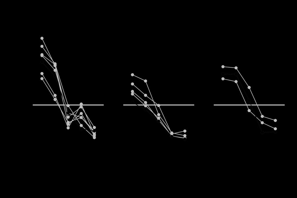
44 Peak count census + regression estimator
45 Results
46 Redds Abernathy Germany Mill Other River Km 20
47 Redds Abernathy Germany Mill Other River Km 20
48 Redds Abernathy Germany Mill Other River Km 20
49 Redds Abernathy Germany Mill Other River Km 20
50 Redds Abernathy Germany Mill Other River Km 20
51 Redd distribution Mill, Abernathy & Germany Cr Coweeman River East Fork Lewis River Variance / mean AutoCorr r r
52 Redd distribution Mill, Abernathy & Germany Cr Coweeman River East Fork Lewis River Variance / mean AutoCorr r r
53 Peak count census + regression estimator
54 Redd distribution Mill, Abernathy & Germany Cr Coweeman River East Fork Lewis River Variance / mean AutoCorr r r
55
56
57
58
59
60

61
62
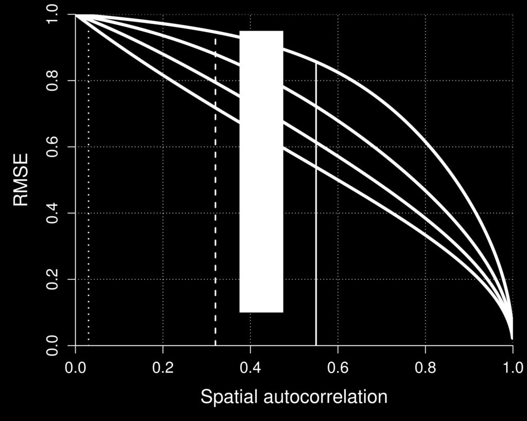
63
64

65
66 Conclusions Redd locations are geographically clumpy This produces much more variable estimates (from sample to sample). There are effective strategies for reducing this variability (GRTS, stratified, regression).
67 Implications Great data set that is likely representative of many other systems. Spatially balanced GRTS is a no-brainer. Stratified design effectiveness depends on the strata. Regression estimator depends on the auxiliary variable. Peak count census works well.
68 Further work Panel designs, etc Other aux. vars. for regression estimators Redds to spawners expansion.
69
70 % Reduction in CV Correlation
71 Steelhead redd distribution (IMW complex) Abernathy Germany Mill N Columbia River
72 Sampling approaches SRS GRTS (Generalized Random Tesselation Stratified) Stratified GRTS Peak count census + regression estimator Strata 1 Strata 2
73 Sampling approaches SRS GRTS (Generalized Random Tesselation Stratified) Stratified GRTS Peak count census + regression estimator
74 Describe spatial distribution
Lower South Fork McKenzie River Floodplain Enhancement Project
 Lower South Fork McKenzie River Floodplain Enhancement Project McKenzie River Ranger District Willamette National Forest Project Location The project is located in the South Fork McKenzie River Watershed,
EXECUTIVE SUMMARY (Continued)
") EXECUTIVE SUMMARY In 1980, Congress passed the Pacific Northwest Electric Power Planning and Conservation Act which authorized creation of the Northwest Power and Conservation Council by the states of
EXECUTIVE SUMMARY In 1980, Congress passed the Pacific Northwest Electric Power Planning and Conservation Act which authorized creation of the Northwest Power and Conservation Council by the states of
2017 Technical Revision to the Marine Survival Forecast of the OCN Coho Work Group Harvest Matrix Erik Suring Oregon Department of Fish and Wildlife
 2017 Technical Revision to the Marine Survival Forecast of the OCN Coho Work Group Harvest Matrix Erik Suring Oregon Department of Fish and Wildlife Agenda Item D.2 Attachment 1 November 2017 Introduction
Steelhead Hatchery Wild Introgression in Puget Sound, WA
 Steelhead Hatchery Wild Introgression in Puget Sound, WA Kenneth I. Warheit WDFW, Olympia WA 2016 Pacific Coast Steelhead Management Meeting ASILOMAR CONFERENCE GROUNDS PACIFIC GROVE, CALIFORNIA MARCH
Columbia Estuary Province
 Rolling Provincial Review: Implementation 2001-2004 Province 73 Columbia Basin Fish & Wildlife Authority Province FY 2001-2004 Spending Summaries NPCC Recommendations and BPA Spending by Project Category,
Appendix A: An Implementation Strategy for Wenatchee River Subbasin Monitoring
 MONITORING STRATEGY FOR THE UPPER COLUMBIA BASIN Appendix A: An Implementation Strategy for Wenatchee River Subbasin March 16, 2009 Prepared by: Pamela Nelle and Michael B. Ward Terraqua, Inc. Wauconda,
Ecosystem response during the removal of the Elwha River Dams
 Ecosystem response during the removal of the Elwha River Dams Presentation Prepared by George Pess - NOAA Photo by John McMillan December 2015 Elwha The Elwha River Basin Olympic Natl. Park > 90% of habitat
2013 Snake River Fall Chinook Salmon Spawning Summary 2,667 2, ,391
 2013 Snake River Fall Chinook Salmon Spawning Summary by Bill Arnsberg, Nez Perce Tribe Phil Groves, Idaho Power Company Frank Mullins, U.S. Fish and Wildlife Service Debbie Milks, Washington Department
Mobrand to Jones and Stokes. Sustainable Fisheries Management Use of EDT
 Sustainable Fisheries Management Use of EDT Ecosystem Diagnosis and Treatment EDT EDT designed to provide a practical, science-based approach for developing and implementing watershed plans. Provides decision
Appendix 12J Winter-Run Chinook Salmon Life Cycle Modeling
 Appendix 12J Winter-Run Chinook Salmon Life Cycle Modeling Line items and numbers identified or noted as No Action Alternative represent the Existing Conditions/No Project/No Action Condition (described
Distributional changes of west coast species and impacts of climate change on species and species groups
 Distributional changes of west coast species and impacts of climate change on species and species groups Elliott Hazen 1 Ole Shelton 2 Eric Ward 2 1 NOAA Southwest Fisheries Science Center 2 NOAA Northwest
THE USE OF GEOSPATIAL DATA TO SUPPORT VULNERABILITY MAPPING OF THE OREGON COAST. Kelvin Raiford MS Candidate Geography Department of Geosciences
 THE USE OF GEOSPATIAL DATA TO SUPPORT VULNERABILITY MAPPING OF THE OREGON COAST Kelvin Raiford MS Candidate Geography Department of Geosciences INTRODUCTION This study is an outcome of the project Geospatial
Smolt Monitoring Program Two Week Passage Index Report Page 1 of 7
 Page 1 of 7 COMBINED YEARLING CHINOOK 09/15/2018 0 0 0 0 09/18/2018 0 0 0 0 0 09/20/2018 0 0 0 0 09/21/2018 0 0 1 0 09/23/2018 1 0 0 09/25/2018 0 1 0 09/26/2018 1 0 0 0 09/28/2018 0 0 0 Total: 0 0 0 0
Photo 1: Assen Brothers Splash Dam in 1912, Middle Creek Oregon. Photo courtesy of Coos County Historical Society
 Spatial Correlation of Historical Salmon Spawning Sites to Historical Splash Dam Locations in the Oregon Coast Range By Rebecca Miller Geo 565 Option 2 Final Introduction Photo 1: Assen Brothers Splash
Lower Columbia Salmon Recovery And Fish & Wildlife Subbasin Plan
 Lower Columbia Salmon Recovery And Fish & Wildlife Subbasin Plan Volume II Subbasin Plan Chapter D Elochoman, Skamakowa, Mill, Abernathy and Germany Grays-Elochoman and Cowlitz Rivers (WRIAS 25-26) Watershed
Columbia River Basin Steelhead Kelt Reconditioning Physiology Research
 Columbia River Basin Steelhead Kelt Reconditioning Physiology Research Andy Pierce 1, 2, Doug Hatch 2, Dave Fast 3, Scott Everett 4, Matt Abrahamse 3, Laura Jenkins 1, Neil Graham 2, Lea Medeiros 1, Jim
ANNUAL STOCK ASSESSMENT - CODED WIRE TAG PROGRAM (ODFW) 2003 Annual Report. Prepared by. Mark A. Lewis William M. Murray
 2003 Annual Report. Prepared by. Mark A. Lewis William M. Murray") ANNUAL STOCK ASSESSMENT - CODED WIRE TAG PROGRAM (ODFW) 2003 Annual Report Prepared by Mark A. Lewis William M. Murray Oregon Department of Fish and Wildlife Prepared For Tracy Yerxa, Technical Representative
ANNUAL STOCK ASSESSMENT - CODED WIRE TAG PROGRAM (ODFW) 2003 Annual Report Prepared by Mark A. Lewis William M. Murray Oregon Department of Fish and Wildlife Prepared For Tracy Yerxa, Technical Representative
Impact of Climate Change on Chinook Salmon
 Region: Western Coastlines Grade Level(s): 5-8 Impact of Climate Change on Chinook Salmon Time Required: 2-3 class periods Focus Question(s): How will long term climate changes impact northwest Pacific
A GIS-Based Approach to Quantifying Pesticide Use Site Proximity to Salmonid Habitat
 A GIS-Based Approach to Quantifying Pesticide Use Site Proximity to Salmonid Habitat Michael Winchell 1, JiSu Bang 2, Barbara Patterson 1, Katie Budreski 1, Richard Brain 2, and Steven Wall 2 1. Stone
Asotin Subbasin Plan. May 2004 Version. Submitted by: Asotin County Conservation District
 Asotin Subbasin Plan Submitted by: Asotin County Conservation District Asotin Subbasin Plan Prepared for Northwest Power and Conservation Council Submitted by Asotin County Conservation District May 28,
Silcott Island met station
 Monitoring and Simulating 3-D Density Currents at the Confluence of the Snake and Clearwater Rivers Christopher B. Cook 1 and Marshall C. Richmond 2 ABSTRACT Summer temperatures in the Lower Snake River
ANALYSIS OF HISTORIC DATA FOR JUVENILE AND ADULT SALMONID PRODUCTION
 FRI-UW-9204 December 1992 ANALYSIS OF HISTORIC DATA FOR JUVENILE AND ADULT SALMONID PRODUCTION RAY HILBORN, MIGUEL PASCUAL, ROBERT DONNELLY, AND CLARIBEL CORONADO-HERNANDEZ Prepared for Pat Poe, Project
Flow-net Relationships in the Forebay of John Day Dam Annual Report 1982
 Flow-net Relationships in the Forebay of John Day Dam Annual Report 1982 DOE/BP-0011 April 1983 This Document should be cited as follows: Giorgi, A., ''Flow-net Relationships in the Forebay of John Day
The general procedure for estimating 24-hour PMP includes the following steps:
 14th Conference on Applied Climatology Abstract # 71520 Using PRISM Climate Grids and GIS for Extreme Precipitation Mapping George H. Taylor and Christopher Daly Oregon State University Corvallis Oregon
Hannah Moore CEE Juvenile Bull Trout Distribution in the South Fork Walla Walla River, Oregon
 Hannah Moore CEE 6440 Juvenile Bull Trout Distribution in the South Fork Walla Walla River, Oregon Introduction Bull trout (Salvelinus confluentus) are an endangered species historically found throughout
Spatio-temporal dynamics of Marbled Murrelet hotspots during nesting in nearshore waters along the Washington to California coast
 Western Washington University Western CEDAR Salish Sea Ecosystem Conference 2014 Salish Sea Ecosystem Conference (Seattle, Wash.) May 1st, 10:30 AM - 12:00 PM Spatio-temporal dynamics of Marbled Murrelet
Key words: resource selection, chinook salmon, redds, Middle-Fork Salmon River, Stillaguamish River, Markov models, model-assisted sampling designs.
 AUTOCORRELATION IN RESOURCE SELECTION FOR CHINOOK SALMON SPAWNING HABITAT JEAN-YVES P. COURBOIS 1, NOAA Fisheries, Northwest Fisheries Sciences Center, Conservation Biology Division, 2725 Montlake Blvd.
An evaluation of the proposed increases in spatial stratification for California salmon fisheries
 1 An evaluation of the proposed increases in spatial stratification for California salmon fisheries Michael O Farrell 1 Melodie Palmer-Zwahlen 2 Jennifer Simon 2 Brett Kormos 2 1 Fisheries Ecology Division,
The role of reproductive timing as a driver of genetic differentiation in populations of Pacific herring
 Western Washington University Western CEDAR Salish Sea Ecosystem Conference 2018 Salish Sea Ecosystem Conference (Seattle, Wash.) Apr 6th, 2:30 PM - 2:45 PM The role of reproductive timing as a driver
Predicting ecosystem response to the removal of the Elwha River Dams, Washington State, U.S.A.
 Predicting ecosystem response to the removal of the Elwha River Dams, Washington State, U.S.A. G.Pess 1, M. McHenry 2,T. Beechie 1, S. Morley 1, J. Duda 3,H. Coe 1, K. Kloehn 1, M. Liermann 1 1 NOAA, Northwest
PNNL R. H. Visser. March Prepared for the U.S. Department of Energy under Contract DE-AC06-76RLO 1830
 PNNL-13177 Using Remotely Sensed Imagery and GIS to Monitor and Research Salmon Spawning: A Case Study of the Hanford Reach Fall Chinook (Oncorhynchus Tshawytscha) R. H. Visser March 2000 Prepared for
Developing a nearshore geospatial framework for recovery assessment and planning
 Western Washington University Western CEDAR Salish Sea Ecosystem Conference 2018 Salish Sea Ecosystem Conference (Seattle, Wash.) Apr 6th, 10:30 AM - 10:45 AM Developing a nearshore geospatial framework
Assessing regional patterns of juvenile salmon growth in the Salish Sea
 Western Washington University Western CEDAR Salish Sea Ecosystem Conference 2014 Salish Sea Ecosystem Conference (Seattle, Wash.) Apr 30th, 1:30 PM - 3:00 PM Assessing regional patterns of juvenile salmon
Lower-Klamath River juvenile salmonid health sampling Seth W. Naman Ashley N. Bowers INTRODUCTION
 Yurok Tribal Fisheries Program Trinity River Division Highway 96 Box 196 Weitchpec Route Hoopa, CA 95546 (530) 625-4130 Lower-Klamath River juvenile salmonid health sampling 2007 Seth W. Naman Ashley N.
Using Big Interagency Databases to Identify Climate Refugia for Idaho s Species of Concern
 Using Big Interagency Databases to Identify Climate Refugia for Idaho s Species of Concern What is a Climate Refugia? habitat that supports a locally reproducing population [or key life history stage]
Predicting ecosystem response to the removal of the Elwha River Dams, Washington State, U.S.A.
 Predicting ecosystem response to the removal of the Elwha River Dams, Washington State, U.S.A. G.Pess 1, M. McHenry 2,T. Beechie 1, S. Morley 1, J. Duda 3,H. Coe 1, K. Kloehn 1, M. Liermann 1 1 NOAA, rthwest
LAKE BILLY CHINOOK by: Steve Fisher. Oregon Geography Content Standards (grade 5):
:") LAKE BILLY CHINOOK by: Steve Fisher OVERVIEW: In this lesson students use historical maps, aerial photographs, personal observation, sketches and oral history to investigate the impact of the damming of
LAKE BILLY CHINOOK by: Steve Fisher OVERVIEW: In this lesson students use historical maps, aerial photographs, personal observation, sketches and oral history to investigate the impact of the damming of
2016 Marine Survival Forecast of Southern British Columbia Coho
 2016 Marine Survival Forecast of Southern British Columbia Coho 2016 MARINE SURVIVAL FORECAST OF SOUTHERN BRITISH COLUMBIA COHO Figure 1: Coho salmon at three life stages: freshwater rearing fry; ocean
Landslide Computer Modeling Potential
 Landslide Computer Modeling Potential Michael D. Dixon, P.E. Civil Engineer Payette National Forest The Payette National Forest selected the Stability Index Mapping (SINMAP) model for use in identifying
Detecting Introgressive Hybridization between Segregated Hatchery and Wild Populations
 Detecting Introgressive Hybridization between Segregated Hatchery and Wild Populations Part II Kenneth I. Warheit 2014 Pacific Coast Steelhead Management Meeting Skamania Lodge, WA March 18, 2014 Prolog
Table of Contents. 1. Executive Summary... 1
 Table of Contents 1. Executive Summary... 1 2. Introduction... 10 2.1 Description of Planning Entity... 10 2.2 List of Participants... 11 2.3 Stakeholder Involvement Process... 12 2.4 Overall Approach
West Branch of the St. Mary s River Restoration Project 2017 Post Construction Report
 West Branch of the St. Mary s River Restoration Project 2017 Post Construction Report Department of Fisheries and Oceans Small Craft Harbours Branch August, 2017 Charles MacInnis, B.Sc. MacInnis Natural
Life-history diversity and ecology of O. mykiss in a coastal California watershed
 Life-history diversity and ecology of O. mykiss in a coastal California watershed Jeremy Monroe Thomas Williams, Dave Rundio, and Steve Lindley NOAA National Marine Fisheries Service, Southwest Fisheries
Juvenile physiology, performance and migration behavior of triploid summer steelhead
 Juvenile physiology, performance and migration behavior of triploid summer steelhead Marc A. Johnson 1 Thomas A. Friesen 1, Andrew H. Dittman 2, Paul M. Olmsted 1, David L. G. Noakes 3, 4, Ryan B. Couture
Blue Mountain Province
 Rolling Provincial Review: Implementation 2001-2003 Province 23 Columbia Basin Fish & Wildlife Authority Province FY 2001-2003 Spending Summaries NPCC Recommendations and BPA Spending by Project Category,
Ocean cycles and climate ENSO, PDO, AMO, AO
 Ocean cycles and climate ENSO, PDO, AMO, AO 3 2.5 2 enso-index 1.5 1 0.5 0-0.5-1 enso 3.4 -index - 1996 to 1999-1.5 1996 1997 1998 1999 Bob Tisdale Bob Tisdale Bob Tisdale ENSO mechanisms animation http://esminfo.prenhall.com/science/geoanimations/animations/26_ninonina.html
Cooperative Institute for Research in Environmental Sciences (CIRES) CU-Boulder 2. National Oceanic and Atmospheric Administration
 CU-Boulder 2. National Oceanic and Atmospheric Administration") Moisture transport during the inland penetrating atmospheric river of early November 006 in the Pacific Northwest: A high-resolution model-based study Michael J. Mueller 1 and Kelly Mahoney 1 Cooperative
Moisture transport during the inland penetrating atmospheric river of early November 006 in the Pacific Northwest: A high-resolution model-based study Michael J. Mueller 1 and Kelly Mahoney 1 Cooperative
Inter State Large Navigable Rivers of the United States
 Inter State Large Navigable Rivers of the United States REVIEW OF NORTH AMERICAN BASINS: GREAT LAKES AND MISSISSIPPI RIVER HELEN A. BROHL, EXECUTIVE DIRECTOR US COMMITTEE ON THE MARINE TRANSPORTATION SYSTEM
Case Study 2: Twenty-mile Creek Rock Fords
 Case Study : Twenty-mile Creek Rock Fords Location Crossing Description Washington. Okanagan National Forest. Methow Valley Ranger District. Chewuch river basin, East Chewuch Road. The Twenty-mile Creek
TRANS-NZOIA COUNTY JOINT EVALUATION EXAMINATION-2014 Kenya Certificate of Secondary Education
 312/2 GEOGRAPHY PAPER 2 JULY/AUGUST 2014 TIME: 2¾ HOURS TRANS-NZOIA COUNTY JOINT EVALUATION EXAMINATION-2014 Kenya Certificate of Secondary Education GEOGRAPHY PAPER 2 TIME: 2¾ HOURS INSTRUCTIONS TO CANDIDATES:
Reproduction & Recovery - Energetics
 Reproduction & Recovery - Energetics Iteroparity & Semelparity Iteroparity- (perennial) reproduces more than once. Semelparity- (annual) reproduces only once. 1 Crespi, B.J. and R. Teo. 2002. Comparative
Lower Columbia Salmon Recovery And Fish & Wildlife Subbasin Plan
 Lower Columbia Salmon Recovery And Fish & Wildlife Subbasin Plan Volume II Subbasin Plan Chapter H Lower Columbia Tributaries: Bonneville and Salmon Salmon-Washougal and Lewis Rivers (WRIAS 27-28) Watershed
Re: Experimental Evaluation of Fishway Modifications on the Passage Behavior of Adult Pacific Lamprey at Bonneville Dam
 Page 1 Summary Report To: David Clugston, USACE From: Eric Johnson, Matt Keefer, and Chris Peery (Fish Ecology Research Laboratory, University of Idaho), and Mary Moser (Northwest Fisheries Science Center,
Community Mapping Network. Selected Coastal Atlases and Information Systems in British Columbia, Canada
 Community Mapping Network Selected Coastal Atlases and Information Systems in British Columbia, Canada Outline Community Mapping Network cmnbc.ca Pacific Coastal Resources Atlas for BC cmnbc.ca The Living
IDENTIFYING INTERACTIONS AMONG SALMON POPULATIONS FROM OBSERVED DYNAMICS MASAMI FUJIWARA 1
 Ecology, 89(1), 2008, pp. 4 11 Ó 2008 by the Ecological Society of America IDENTIFYING INTERACTIONS AMONG SALMON POPULATIONS FROM OBSERVED DYNAMICS MASAMI FUJIWARA 1 Fisheries Ecology Division, Southwest
El Niño Seasonal Weather Impacts from the OLR Event Perspective
 Science and Technology Infusion Climate Bulletin NOAA s National Weather Service 41 st NOAA Annual Climate Diagnostics and Prediction Workshop Orono, ME, 3-6 October 2016 2015-16 El Niño Seasonal Weather
Estimating the relative abundance of juvenile coho salmon in the Strait of Georgia using trawls
 NPAFC Doc. No. 348 Rev. No. Estimating the relative abundance of juvenile coho salmon in the Strait of Georgia using trawls R.J. Beamish, D. McCaughran, J. R. King, R.M. Sweeting and G. A. McFarlane Pacific
Winter Climate Forecast
 Winter 2017-2018 Climate Forecast 25 th Winter Weather Meeting, OMSI and Oregon AMS, Portland Kyle Dittmer Hydrologist-Meteorologist Columbia River Inter-Tribal Fish Commission Portland, Oregon Professor
CW3E Atmospheric River Update
 CW3E Atmospheric River Update Update on Late Season AR Forecast to Impact West Coast Later This Week - Little change from yesterday s forecast - Ensemble GFS members are still in good agreement of the
U.S. Fish & Wildlife Service
 U.S. Fish & Wildlife Service Abundance and Run Timing of Adult Pacific Salmon in the East Fork Andreafsky River, Yukon Delta National Wildlife Refuge, Alaska, 2007 Alaska Fisheries Data Series Number 2008-6
A GEOGRAPHIC ASSESSMENT OF MAJOR DISASTER DECLARATIONS ACROSS THE LOWER 48 STATES
 A GEOGRAPHIC ASSESSMENT OF MAJOR DISASTER DECLARATIONS ACROSS THE LOWER 48 STATES A summary report produced by the Southern Climate Impacts Planning Program (SCIPP) Author: James Hocker Southern Climate
FEATHER RIVER HATCHERY GAMETE TRACKING PROGRAM
 FEATHER RIVER HATCHERY GAMETE TRACKING PROGRAM WHY? Began with Spring Run. WHY? WHY? Began with Spring Run. Spring Run were used for Brood stock for San Joaquin River salmon restoration project WHY? Began
Lower Columbia Salmon Recovery And Fish & Wildlife Subbasin Plan. Volume II Subbasin Plan Chapter F Kalama
 Lower Columbia Salmon Recovery And Fish & Wildlife Subbasin Plan Volume II Subbasin Plan Chapter F Kalama Salmon-Washougal and Lewis Rivers (WRIAS 27-28) Watershed Management Plan Chapter 6 Appendix Management
ODFW AQUATIC INVENTORY PROJECT OREGON PLAN FOR SALMON & WATERSHEDS STREAM RESTORATION HABITAT REPORT
 ODFW AQUATIC INVENTORY PROJECT OREGON PLAN FOR SALMON & WATERSHEDS STREAM RESTORATION HABITAT REPORT STREAM: BASIN: SURVEY TYPE: Munson Creek (NC-342) Tillamook River Post-Tx DATE: February 2, 28 SURVEY
Geospatial dynamics of Northwest. fisheries in the 1990s and 2000s: environmental and trophic impacts
 Geospatial dynamics of Northwest Atlantic ti cod and crustacean fisheries in the 1990s and 2000s: environmental and trophic impacts Matthew J.S. WINDLE 1, George A. ROSE 2, Rodolphe DEVILLERS 3, and Marie-Josée
Big Sharks in the Salish Sea: combining passive acoustics with the Salish Sea model to predict Sixgill Shark (Hexanchus griseus) presence
 presence") Western Washington University Western CEDAR Salish Sea Ecosystem Conference 2018 Salish Sea Ecosystem Conference (Seattle, Wash.) Apr 5th, 2:30 PM - 2:45 PM Big Sharks in the Salish Sea: combining passive
Western Washington University Western CEDAR Salish Sea Ecosystem Conference 2018 Salish Sea Ecosystem Conference (Seattle, Wash.) Apr 5th, 2:30 PM - 2:45 PM Big Sharks in the Salish Sea: combining passive
ICES training Course on Design and Analysis of Statistically Sound Catch Sampling Programmes
 ICES training Course on Design and Analysis of Statistically Sound Catch Sampling Programmes Sara-Jane Moore www.marine.ie General Statistics - backed up by case studies General Introduction to sampling
Skagit River History. Floods, River Migration, Projects, Fish, Farms, The Future
 Skagit River History Floods, River Migration, Projects, Fish, Farms, The Future Presentation to: AWARE Presentation by: Larry Kunzler, 11/16/2006 www.skagitriverhistory.com HISTORICAL NEWSPAPER PROJECT
Using PRISM Climate Grids and GIS for Extreme Precipitation Mapping
 Using PRISM Climate Grids and GIS for Extreme Precipitation Mapping George H. Taylor, State Climatologist Oregon Climate Service 316 Strand Ag Hall Oregon State University Corvallis OR 97331-2209 Tel:
Socio-Economic Atlas of Tajikistan. The World Bank THE STATE STATISTICAL COMMITTEE OF THE REPUBLIC OF TAJIKISTAN
 Socio-Economic Atlas of Tajikistan The World Bank THE STATE STATISTICAL COMMITTEE OF THE REPUBLIC OF TAJIKISTAN 1) Background Why there is a need for socio economic atlas? Need for a better understanding
OREGON DEPARTMENT OF FISH AND WILDLIFE 2015 Sport Fishing Catch - Fall Chinook Expanded numbers by month 'Final' Version
 OREGON DEPARTMENT OF FISH AND WILDLIFE 2015 Sport Fishing Catch - Fall Chinook Expanded numbers by month 'Final' Version Based upon Run Year Code Location Name Jan Feb Mar Apr May Jun Jul Aug Sep Oct Nov
OREGON DEPARTMENT OF FISH AND WILDLIFE 2015 Sport Fishing Catch - Spring Chinook Expanded numbers by month 'Final' Version
 OREGON DEPARTMENT OF FISH AND WILDLIFE 2015 Sport Fishing Catch - Spring Chinook Expanded numbers by month 'Final' Version Based upon Run Year Code Location Name Jan Feb Mar Apr May Jun Jul Aug Sep Oct
2016 New Ward Boundaries Guidance on calculating statistics for the new 2016 wards
 2016 New Ward Boundaries Page 1 Performance, Information and Intelligence 2016 New Ward Boundaries Guidance on calculating statistics for the new 2016 wards Briefing Note February 2016 2016 New Ward Boundaries
USE OF STATISTICAL BOOTSTRAPPING FOR SAMPLE SIZE DETERMINATION TO ESTIMATE LENGTH-FREQUENCY DISTRIBUTIONS FOR PACIFIC ALBACORE TUNA (THUNNUS ALALUNGA)
") FRI-UW-992 March 1999 USE OF STATISTICAL BOOTSTRAPPING FOR SAMPLE SIZE DETERMINATION TO ESTIMATE LENGTH-FREQUENCY DISTRIBUTIONS FOR PACIFIC ALBACORE TUNA (THUNNUS ALALUNGA) M. GOMEZ-BUCKLEY, L. CONQUEST,
FRI-UW-992 March 1999 USE OF STATISTICAL BOOTSTRAPPING FOR SAMPLE SIZE DETERMINATION TO ESTIMATE LENGTH-FREQUENCY DISTRIBUTIONS FOR PACIFIC ALBACORE TUNA (THUNNUS ALALUNGA) M. GOMEZ-BUCKLEY, L. CONQUEST,
Start of Presentation: No notes (Introductory Slide 1) 1) Salmonid Habitat Intrinsic Potential (IP) models are a type of habitat potential
 1) Salmonid Habitat Intrinsic Potential (IP) models are a type of habitat potential") The What and How of Salmonid Habitat Intrinsic Potential Modeling Start of Presentation: No notes (Introductory Slide 1) 1) Salmonid Habitat Intrinsic Potential (IP) models are a type of habitat potential
The What and How of Salmonid Habitat Intrinsic Potential Modeling Start of Presentation: No notes (Introductory Slide 1) 1) Salmonid Habitat Intrinsic Potential (IP) models are a type of habitat potential
Quizzes 7, 8 & 9. Review. Cathy Poliak, Ph.D. (Department of Mathematics ReviewUniversity of Houston ) May 25, 2017
 May 25, 2017") Quizzes 7, 8 & 9 Review Cathy Poliak, Ph.D. cathy@math.uh.edu Department of Mathematics University of Houston May 25, 2017 May 25, 2017 1 / 19 Outline 1 Quiz 7 2 Quiz 8 3 Quiz 9 May 25, 2017 2 / 19 Example
Quizzes 7, 8 & 9 Review Cathy Poliak, Ph.D. cathy@math.uh.edu Department of Mathematics University of Houston May 25, 2017 May 25, 2017 1 / 19 Outline 1 Quiz 7 2 Quiz 8 3 Quiz 9 May 25, 2017 2 / 19 Example
HAB Forecaster. For info on HABs in the Pacific Northwest see:
 HAB Forecaster BACKGROUND In this activity, students can take on the role as a resource manager or scientist, tasked with deciding if razor clam harvesters should go out onto the beach to harvest razor
1) NetMap Overview. 2) Habitat modeling HIP & Beyond. 3) What do you do with habitat models? 4) NetMap a platform for regional analysis & interactions
 NetMap Overview. 2) Habitat modeling HIP & Beyond. 3) What do you do with habitat models? 4) NetMap a platform for regional analysis & interactions") 1) NetMap Overview 2) Habitat modeling HIP & Beyond 3) What do you do with habitat models? 4) NetMap a platform for regional analysis & interactions Overview Multiple analysis tools Creates universal stream/hillslope
1) NetMap Overview 2) Habitat modeling HIP & Beyond 3) What do you do with habitat models? 4) NetMap a platform for regional analysis & interactions Overview Multiple analysis tools Creates universal stream/hillslope
Coastal Impacts of Climate Change in the Northwest: A Summary of the Findings of the upcoming National Climate Assessment
 Western Washington University Western CEDAR Salish Sea Ecosystem Conference 2014 Salish Sea Ecosystem Conference (Seattle, Wash.) May 1st, 3:30 PM - 5:00 PM Coastal Impacts of Climate Change in the Northwest:
Opportunities to Improve Ecological Functions of Floodplains and Reduce Flood Risk along Major Rivers in the Puget Sound Basin
 Opportunities to Improve Ecological Functions of Floodplains and Reduce Flood Risk along Major Rivers in the Puget Sound Basin Christopher Konrad, US Geological Survey Tim Beechie, NOAA Fisheries Managing
A comparison of weighted estimators for the population mean. Ye Yang Weighting in surveys group
 A comparison of weighted estimators for the population mean Ye Yang Weighting in surveys group Motivation Survey sample in which auxiliary variables are known for the population and an outcome variable
ALASKA OCEAN OBSERVING SYSTEM 2016 ANNUAL IMPACT REPORT
 ALASKA OCEAN OBSERVING SYSTEM 2016 ANNUAL IMPACT REPORT 1 ALASKA OCEAN OBSERVING SYSTEM 2016 ANNUAL IMPACT REPORT 2 ALASKA OCEAN OBSERVING SYSTEM 2016 ANNUAL IMPACT REPORT Letter from Executive Director
Task. Variance Estimation in EU-SILC Survey. Gini coefficient. Estimates of Gini Index
 Variance Estimation in EU-SILC Survey MārtiĦš Liberts Central Statistical Bureau of Latvia Task To estimate sampling error for Gini coefficient estimated from social sample surveys (EU-SILC) Estimation
Canada s Policy for the Conservation of Wild Pacific Salmon: conservation planning for an uncertain future.
 Canada s Policy for the Conservation of Wild Pacific Salmon: conservation planning for an uncertain future. Brian Riddell and Blair Holtby, Dept. Fisheries & Oceans, Science Branch, Pacific Biological
CLIMAR-III Third JCOMM Workshop on Advances in Marine Climatology 6-9 May Gdynia, Poland
 CLIMAR-III Third JCOMM Workshop on Advances in Marine Climatology 6-9 May 2008. Gdynia, Poland Catherine Marzin Historical Ecology Program Manager National Marine Sanctuary Program Stefan Claesson Research
Mount St. Helens Ecosystem Restoration General Reevaluation Study Reconnaissance Report
 Mount St. Helens Ecosystem Restoration General Reevaluation Study Reconnaissance Report Sediment Retention Structure on the North Fork Toutle River Report Documentation Page Form Approved OMB No. 0704-0188
Presentation Outline. Project Overview. Sea Level Rise Assessment & Decision Tools. Community Engagement. Tina Whitman, Friends of the San Juans
 Healthy Beaches for People & Fish Sea Level Rise Adaptation Tools for San Juan County, WA Tina Whitman & Andrea MacLennan December 10, 2015 Presentation Outline Project Overview Tina Whitman, Friends of
ACCUMULATED PRECIPITATION IN INCHES
 CUMULATIVE PRECIPITATION WATER YEAR COLUMBIA BASIN ABOVE GRAND COULEE 84% of Normal 1971- Average ACCUMULATED PRECIPITATION IN INCHES 8 6 82% of Normal 85% of Normal 82% of Normal SNAKE RIVER BASIN ABOVE
ACOUSTIC ASSESSMENT OF BAITFISH STOCKS IN PUGET SOUND. Final Report Service Contract No. 501 Washington Department of Fisheries 1973
 FRI UW 7 312 August 1973 ACOUSTIC ASSESSMENT OF BAITFISH STOCKS IN PUGET SOUND by Richard E. Thorne Final Report Service Contract No. 501 Washington Department of Fisheries 1973 Approved Submitted: Aug.
A partnership with the Colorado Basin River Forecast Center: An experiment in Technology Transfer
 A partnership with the Colorado Basin River Forecast Center: An experiment in Technology Transfer Martyn P. Clark and Subhrendu Gangopadhyay Center for Science and Technology Policy Research David Brandon,
SEDAR 42- DW November 2014
 Red Grouper Abundance Indices from NMFS Bottom Longline Surveys in the Northern Gulf of Mexico Adam G. Pollack and G. Walter Ingram, Jr. SEDAR 42- DW- 06 19 November 2014 This information is distributed
Weather and Climate Summary and Forecast Winter
 Weather and Climate Summary and Forecast Winter 2016-17 Gregory V. Jones Southern Oregon University February 7, 2017 What a difference from last year at this time. Temperatures in January and February
GeoDa-GWR Results: GeoDa-GWR Output (portion only): Program began at 4/8/2016 4:40:38 PM
: Program began at 4/8/2016 4:40:38 PM") New Mexico Health Insurance Coverage, 2009-2013 Exploratory, Ordinary Least Squares, and Geographically Weighted Regression Using GeoDa-GWR, R, and QGIS Larry Spear 4/13/2016 (Draft) A dataset consisting
New Mexico Health Insurance Coverage, 2009-2013 Exploratory, Ordinary Least Squares, and Geographically Weighted Regression Using GeoDa-GWR, R, and QGIS Larry Spear 4/13/2016 (Draft) A dataset consisting
An evaluation of preseason abundance forecasts for Sacramento River winter Chinook salmon
 Agenda Item D.2 Attachment 1 November 216 An evaluation of preseason abundance forecasts for Sacramento River winter Chinook salmon Michael O Farrell 1 Noble Hendrix 2 Michael Mohr 1 1 Fisheries Ecology
UPPER COLUMBIA UNITED TRIBES
 UPPER COLUMBIA UNITED TRIBES 910 N. Washington, Suite 107 Spokane, Washington 99201 (509) 838-1057 Colville * Coeur d Alene * Kalispel * Kootenai * Spokane May 27, 2004 Judi Danielson, Chair Northwest
2013 Aerial Moose Survey Final Results
 2013 Aerial Moose Survey Final Results Glenn D. DelGiudice, Forest Wildlife Populations and Research Group Introduction Each year, we conduct an aerial survey in northeastern Minnesota in an effort to
Length and age frequency distributions for vermilion snappers collected in the Gulf of Mexico from 1981 to Ching-Ping Chih SEDAR45-WP-08
 Length and age frequency distributions for vermilion snappers collected in the Gulf of Mexico from 1981 to 2014 Ching-Ping Chih SEDAR45-WP-08 9 November 2015 This information is distributed solely for
HUMAN IMPACTS AND RIVER CHANNEL ADJUSTMENT, NORTHEASTERN OREGON: IMPLICATIONS FOR RESTORATION. Patricia F. McDowell 1 INTRODUCTION
 Forthcoming in: Riparian Ecology and Management in Multi-Land Use Watersheds Symposium Proceedings, American Water Resources Association, Annual International Summer Specialty Conference, August 27-30,
The Refugia Concept: Using Watershed Analysis to Prioritize Salmonid Habitat for Conservation and Restoration
 The Refugia Concept: Using Watershed Analysis to Prioritize Salmonid Habitat for Conservation and Restoration Christopher May Battelle & UW Cumulative Impacts of Urbanization Landscape Alterations Loss
February 27, Jim Ruff, Manager, Mainstem Passage and River Operations. March 2008 Runoff Forecast and Power Supply Status
 W. Bill Booth Chair Idaho James A. Yost Idaho Tom Karier Washington Richard K. Wallace Washington Bruce A. Measure Vice-Chair Montana Rhonda Whiting Montana Melinda S. Eden Oregon Joan M. Dukes Oregon