Preliminary Earthquake Report
|
|
|
- Mervin Stevenson
- 5 years ago
- Views:
Transcription

1 THE UNIVERSITY OF THE WEST INDIES ST. AUGUSTINE, TRINIDAD AND TOBAGO, WEST INDIES THE SEISMIC RESEARCH CENTRE Telephone: (868) Website: Preliminary Earthquake Report UTC Mt 5.5 STRONG MOTION PARAMETERS FOR PORT OF SPAIN FROM LOCAL STRONG MOTION NETWORK & INTENSITY REPORT FROM CITIZEN SEISMOLOGIST COMMUNITY PROJECT Ilias Papadopoulos, Celeste Sobion & Hannah Ramsingh Tel: ; Fax: /07/05
2 The results of the present report are preliminary and may be subject to revision if more detailed analyses will be carried out. The uncorrected data of the records in ASCII are available upon request. DISCLAIMER This report was compiled by the Engineering Seismologist of The University of the West Indies Seismic Research Centre Ilias Papadopoulos. The accuracy and credibility of the results and the opinions expressed in this report are solely his and do not necessary reflect those of the Centre.
3 Contents Summary... 4 Earthquake Parameters (Source: UWI SRC)... 5 Port of Spain General Hospital (PSGH)... 6 Strong Motion Parameters... 7 Elastic Response Spectra (SA)... 8 Fourier Amplitude Spectra... 9 PSGH Particle Motion Comparison with IBC2000 Design Spectra Kent House (PSKH) Strong Motion Parameters Elastic Response Spectra Fourier Amplitude Spectra PSKH Particle Motion Comparison with IBC2000 Design Spectra Mucurapo Girls RC (PSMG) Strong Motion Parameters Elastic Response Spectra (SA) Fourier Amplitude Spectra PSMG Particle Motion Comparison with IBC2000 Design Spectra Woodbrook Secondary (PSWS) Strong Motion Parameters Elastic Response Spectra (SA) Fourier Amplitude Spectra PSWS Particle Motion Comparison with IBC2000 Design Spectra Analysis of the Citizen Seismologist Community Project Felt Reports Demographics Perception of Seismic Shaking Intensity... 29
4 Summary This document serves as a preliminary report for the moderate earthquake occurred in 2018/06/22, 01:54 UTC (21:54 local time) northwest of Trinidad (Coordinates N, W) (source:src). Its focal depth of Km allowed the shaking to be felt to a wider area. The Port of Spain Strong Motion Network (POS SMN) recorded the event, and the strong motion data processing appears in this document. At the second section of this document the intensity report is presented, as recorded by the SRC s Citizen Seismologist Community Project. The maximum instrumentally recorded PGA value in the area of Port of Spain is recorded in Maraval, at station PSKH (PGA= m/s 2 ), while the highest intensity values in Modified Mercalli Intensity (MMI) Scale appear in reports from Maraval, Woodbrook and St. James (MMI=V). There have been no reports of casualties or damages. Initial results indicate that the western part of Port of Spain experienced higher seismic intensity compared to the eastern side. This appears both in the instrumental recorded waveforms and community felt reports. The geophysical survey conducted by SRC the past years in Port of Spain shows the western part to have a thicker package of sediments compared to the eastern side, while the geological survey shows that the soil deposits of the eastern side are more compacted. The areas of St. Claire, Woodbrook and St. James are the natural flood plains of the Maraval River and the water table of the underground aquifer appears at shallower depths at the west (less than 1m). All these indicate that the western side of Port of Spain is to experience higher levels of shaking, especially as it gets closer to the coast, where also reclamation has been conducted in the past. Station PSWS, located at Woodbrook Secondary School, experienced a short break in transmission of data, creating a gap in data recorded in the vertical component. We were unable to retrieve the whole waveform for this component from that station, hence the results for this component are incomplete.

5 SECTION 1 STRONG MOTION PARAMETERS Earthquake Parameters (Source: UWI SRC) Date Time 0154 UTC Latitude N Longitude W Depth km Magnitude (Mt) 5.5 Mean Epicentral Distance from POS SMN 92.5 Km Mean Hypocetral Distance from POS SMN Km Mean Azimouth 98 o Figure 1. Google image showing the location of the earthquake event on June 6 th, UTC.
6 Port of Spain General Hospital (PSGH) Port of Spain General Hospital (PSGH) Longitude W Soil Type Soft Latitude N Vs 30 (m/s) 420 Elevation (m) 15.5 NEHRP Class C Building Structure Wood Resonance Frequency 2.2 Installation Surface/Concrete Sensor Guralp 5TDE Telemetry Internet/Wired Digitizer Guralp DM24 Mean PGA (m/s 2 ) Mean Period (s) Figure 2. PSGH unfiltered waveform (Z: Vertical; N: North-South; E: East-West). Units in m/s 2.
; Time Histories, unfiltered (Bottom).")
7 Strong Motion Parameters Figure 3. Strong Motion Parameters (Top); Time Histories, unfiltered (Bottom). Units: a (m/s 2 ), V (cm/s), D (cm)
8 Elastic Response Spectra (SA) Figure 4. Elastic Response Spectra. SA (top left), SV (bottom left), SD (top right) & all damping. Units: SA (m/s 2 ), SV (cm/s), SD (cm). Components: Z: Vertical; N: North-South; E: East-West.
9 Fourier Amplitude Spectra Figure 5. Fourier Amplitude Spectrum, three components and summary. Comparison between noise & signal (top), signal-to-noise ratio (bottom). Components: Z: Vertical; N: North-South; E: East-West..

10 PSGH Particle Motion Figure 6. Particle motion, horizontal plane. Comparison with IBC2000 Design Spectra Figure 7. Comparison of elastic response spectra damping with IBC2000 Design Spectrum.
11 Kent House (PSKH) Kent House (PSKH) Longitude W Soil Type Soft Latitude N Vs 30 (m/s) 440 Elevation (m) 25.4 NEHRP Class C Building Structure Free Field Resonance Frequency 3.2 Installation Surface/Concrete Sensor Guralp 5TDE Telemetry Internet/Wired Digitizer Guralp DM24 Mean PGA (m/s 2 ) Mean Period (s) Figure 8. PSKH recording (Z: Vertical; N: North-South; E: East-West). Units in m/s 2.
; Time Histories, unfiltered (Bottom).")
12 Strong Motion Parameters Figure 9. Strong Motion Parameters (Top); Time Histories, unfiltered (Bottom). Units: a (m/s 2 ), V (cm/s), D (cm)
13 Elastic Response Spectra Figure 10. Elastic Response Spectrum, Units: Units: SA (cm/s 2 ), SV (cm/s), SD (cm). Components: Z: Vertical; N: North-South; E: East-West.
, signal-to-noise ratio (bottom).")
14 Fourier Amplitude Spectra Figure 11. Fourier Amplitude Spectrum, three components and summary. Comparison between noise & signal (top), signal-to-noise ratio (bottom). Components: Z: Vertical; N: North-South; E: East-West..

15 PSKH Particle Motion Figure 12. Particle motion, horizontal plane. Comparison with IBC2000 Design Spectra Figure 13. Comparison of elastic response spectra damping with IBC2000 Design Spectrum.
16 Mucurapo Girls RC (PSMG) Mucurapo Girls RC (PSMG) Longitude W Soil Type Soft Latitude N Vs 30 (m/s) 370 Elevation (m) 8.1 NEHRP Class C/D Building Structure Free Field Resonance Frequency 1.4 Installation Surface/Concrete Sensor Guralp 5TDE Telemetry Internet/Wireless Digitizer Guralp DM24 Mean PGA (m/s 2 ) Mean Period (s) Figure 14. PSMG recording (Z: Vertical; N: North-South; E: East-West). Units in m/s 2.
17 Strong Motion Parameters Figure 15. Strong Motion Parameters (Top); Time Histories, unfiltered (Bottom). Units: a (m/s 2 ), V (cm/s), D (cm)
18 Elastic Response Spectra (SA) Figure 16. Elastic Response Spectra, Units: Units: SA (m/s 2 ), SV (cm/s), SD (cm). Components: Z: Vertical; N: North-South; E: East-West.
, signal-to-noise ratio (bottom).")
19 Fourier Amplitude Spectra Figure 17. Fourier Amplitude Spectrum, three components and summary. Comparison between noise & signal (top), signal-to-noise ratio (bottom). Components: Z: Vertical; N: North-South; E: East-West..
20 PSMG Particle Motion Figure 18. Particle motion, horizontal plane. Comparison with IBC2000 Design Spectra Figure 19. Comparison of elastic response spectra damping with IBC2000 Design Spectrum.
 0.")
21 Woodbrook Secondary (PSWS) Woodbrook Secondary (PSWS) Longitude W Soil Type Soft Latitude N Vs 30 (m/s) 363 Elevation (m) 5.5 NEHRP Class C/D Building Structure Reinforced Concrete Resonance Frequency 0.9 Installation Surface/Concrete Sensor Guralp 5TDE Telemetry Internet/Wireless Digitizer Guralp DM24 Mean PGA (m/s 2 ) Mean Period (s) Figure 20. PSWS recording (Z: Vertical; N: North-South; E: East-West). Units in m/s 2.
22 Strong Motion Parameters Figure 21. Strong Motion Parameters (Top); Time Histories, unfiltered (Bottom). Units: a (m/s 2 ), V (cm/s), D (cm)
, SV (cm/s), SD (cm).")
23 Elastic Response Spectra (SA) Figure 22. Elastic Response Spectra, Units: Units: SA (m/s 2 ), SV (cm/s), SD (cm). Components: Z: Vertical; N: North-South; E: East-West.
24 Fourier Amplitude Spectra Figure 23.. Fourier Amplitude Spectrum, three components and summary. Comparison between noise & signal (top), signal-to-noise ratio (bottom). Components: Z: Vertical; N: North-South; E: East-West..
25 PSWS Particle Motion Figure 24. Particle motion, horizontal plane. Comparison with IBC2000 Design Spectra Figure 25. Comparison of elastic response spectra damping with IBC2000 Design Spectrum.
26 SECTION 2 MODIFIED MERCALLI INTENSITY REPORTS


27 Figure 26. Nationwide Modified Mercalli Intensity values. Figure 27. Port of Spain Intensity map. With green dots the POS SMN is presented. Size according to maximum recorded PGA value. Also shown is the MMI value from felt reports.
28 Analysis of the Citizen Seismologist Community Project Felt Reports Demographics Reports Demographics Submitted 346 Urban Not available Complete 346 Rural Not available Reliable 342 Female 275 Usable 90 Male 65 Comments Submitted: Total submitted online reports Complete: Reports with all fields filled Reliable: Reports considered filled with good will and faith Usable: Reports with exact location to be place on a map Urban: Total submitted reports indicating address in urban areas Rural: Total submitted reports indicating address in rural areas Female: Total submitted reports filled by female Male: Total submitted reports filled by male
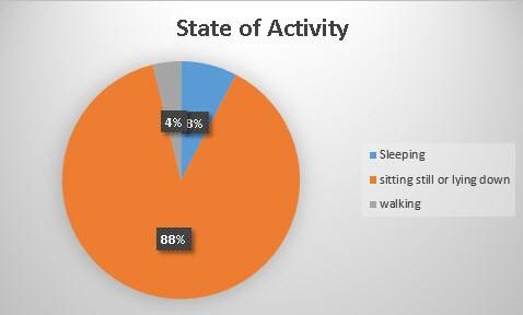
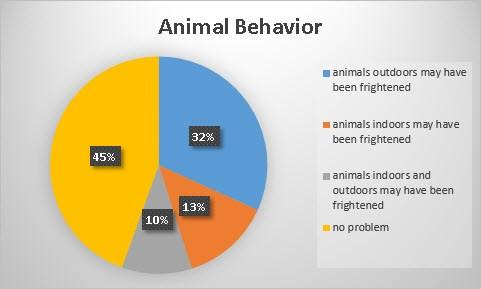
29 Perception of Seismic Shaking Intensity From the statistical analysis of the reliable felt reports, the earthquake of 01:54 UTC was reported felt in 97.2% of submitted reports. Most of the reports were filled by female (81%). The majority of reports consider the earthquake shaking moderate (46%), while the shaking is described mostly as trembling or swaying (32% and 33% respectively). At the time of the event (21:54, local time) most people were awake and sitting still or laying down (88%). The event caught T&T s citizens by surprise (46%), while enough expressed fear (34%). Animals nearby (indoors and outdoors) got upset (87%). Most submissions, report light swing of hanging objects (57%), while doors, windows, china and glasses rattled (52-53%). The majority reports a sound effect (58%), which appeared before (37%) or during (60%) the ground shaking. Reports are almost equally divided in the origin of the sound effect, either from inside the building or from underground. While no significant damages are reported, a small percentage of reports indicate cracks on the wall and plaster falling from ceiling (6%). No other damage reported on walls or collapses. The biggest concern from the authors of this report, is the amount of submissions that are unusable for scientific research (74.4%), due to lack of precise location. While some citizens failed to provide an address, by negligence or typing something irrelevant (e.g. my house) or providing fewer details (e.g. Eastern Main Road), some others don t have an address to report that can be of use (e.g. Lamp Post 23, Maraval Road). Within the frame of Citizen Seismologist Community Project, an effort needs to be made for these citizens to be able to determine accurately their location, in order for SRC to use the essential information provided.


30

31
Preliminary Earthquake Report
 Preliminary Earthquake Report 20180821 21:31 UTC Mt 6.9 (Main Event) 20180822 13:27 UTC Mt 6.0 (Aftershock) STRONG MOTION PARAMETERS FOR PORT OF SPAIN FROM LOCAL STRONG MOTION NETWORK & INTENSITY REPORT
Earthquakes. Dr. Mark van der Meijde INTERNATIONAL INSTITUTE FOR GEO-INFORMATION SCIENCE AND EARTH OBSERVATION
 Earthquakes Dr. Mark van der Meijde vandermeijde@itc.nl INTERNATIONAL INSTITUTE FOR GEO-INFORMATION SCIENCE AND EARTH OBSERVATION Topics to handle Theory of earthquakes Mechanism Strength Measurements
Engineering Characteristics of Ground Motion Records of the Val-des-Bois, Quebec, Earthquake of June 23, 2010
 CSCE 2011 General Conference - Congrès générale 2011 de la SCGC Ottawa, Ontario June 14-17, 2011 / 14 au 17 juin 2011 Engineering Characteristics of Ground Motion Records of the Val-des-Bois, Quebec, Earthquake
September 28, 2004 Parkfield Earthquake
 PRELIMINARY REPORT ON SEPTEMBER 28, 2004 PARKFIELD EARTHQUAKE By Rakesh K. Goel, M.EERI and Charles B. Chadwell, M. EERI Department of Civil & Environmental Engineering, California Polytechnic State University,
Mw 7.8, Southwest of Sumatra, Indonesia Wed, 2 March 2016 at 12:49:48 UTC M /03/03
 Earthquake overview AFGHANISTA N PAKISTA N INDIA A moment magnitude (Mw) 7.8 earthquake struck in South West, Indonesia. The epicentre was centered about 800 km West South West of Padang, Sumatra province,
earthquakes 1. Earthquakes occur when plates grind against one another along cracks called faults.
 earthquakes BEGIN 1 earthquakes 1. Earthquakes occur when plates grind against one another along cracks called faults. 2 earthquakes 1. Earthquakes occur when plates grind against one another along cracks
Magnitude 6.3 SOUTH ISLAND OF NEW ZEALAND
 A magnitude 6.3 earthquake shook the southern New Zealand city of Christchurch. At least 100 people are reported dead, and there are reports of collapsed buildings, cracked streets and flooding due to
Section 19.1: Forces Within Earth Section 19.2: Seismic Waves and Earth s Interior Section 19.3: Measuring and Locating.
 CH Earthquakes Section 19.1: Forces Within Earth Section 19.2: Seismic Waves and Earth s Interior Section 19.3: Measuring and Locating Earthquakes Section 19.4: Earthquakes and Society Section 19.1 Forces
Released Science Inquiry Task Location Grade 11
 Date: Your Name: Released Science Inquiry Task Location 2009 Grade 11 Science Directions: You will be completing an extended-response inquiry task called Location. Explain the reasons for all of your answers.
Section Forces Within Earth. 8 th Grade Earth & Space Science - Class Notes
 Section 19.1 - Forces Within Earth 8 th Grade Earth & Space Science - Class Notes Stress and Strain Stress - is the total force acting on crustal rocks per unit of area (cause) Strain deformation of materials
Unique Site Conditions and Response Analysis Challenges in the Central and Eastern U.S.
 Unique Site Conditions and Response Analysis Challenges in the Central and Eastern U.S. James R. Martin, C. Guney Olgun, & Morgan Eddy Civil and Environmental Engineering World Institute for Disaster Risk
INVESTIGATION ON ATTENUATION CHARACTERISTICS OF STRONG GROUND MOTIONS IN CHINA AND HONG KONG
 INVESTIGATION ON ATTENUATION CHARACTERISTICS OF STRONG GROUND MOTIONS IN CHINA AND HONG KONG Y L WONG 1 And John X ZHAO SUMMARY We present qualitative evidence that strong-motion attenuation characteristics
Magnitude 7.7 QUEEN CHARLOTTE ISLANDS REGION
 A major 7.7 magnitude earthquake struck at 8:04 PM local time in western British Columbia, Canada. The epicenter is located on Moresby Island, the southern large island in the Queen Charlotte Islands region.
C2.2 The physics of Earthquakes
 C2.2 The physics of Earthquakes C2.2.1 Stress axes and faults Most earthquakes occur because of the mechanical failure on brittle faults. The type of faulting is a consequence of the stress pattern causing
Earthquakes and Earth s Interior
 - What are Earthquakes? Earthquakes and Earth s Interior - The shaking or trembling caused by the sudden release of energy - Usually associated with faulting or breaking of rocks - Continuing adjustment
Three Fs of earthquakes: forces, faults, and friction. Slow accumulation and rapid release of elastic energy.
 Earthquake Machine Stick-slip: Elastic Rebound Theory Jerky motions on faults produce EQs Three Fs of earthquakes: forces, faults, and friction. Slow accumulation and rapid release of elastic energy. Three
20.1 Earthquakes. Chapter 20 EARTHQUAKES AND VOLCANOES. Earthquakes and plate boundaries 500 UNIT 6 EARTH S STRUCTURE
 Chapter 20 EARTHQUAKES AND VOLCANOES 20.1 Earthquakes In Chapter 19, you read about the San Andreas Fault, which lies along the California coast (Figure 20.1). This fault passes right through San Francisco
Identifying the causes and effects of earthquakes
 Science 3 Physical Earth and Space Life LESSON 57 Identifying the causes and effects of earthquakes Lesson Preparation Program Materials Child s Booklet E Exploring the Earth s Structure (pp. 12 13) Optional:
1. Why do earthquakes happen? 3. What type of mechanical waves are Primary or P waves? 4. What type of mechanical waves are Secondary or S waves?
 Name Period Earthquake Activity Background Information Earthquakes occur because of a sudden release of stored energy. This energy has built up over long periods of time as a result of tectonic forces
SEISMOLOGY. - The study of earthquakes waves and how they move through the body and around the surface of the earth.
 EARTHQUAKES SEISMOLOGY - The study of earthquakes waves and how they move through the body and around the surface of the earth. Seismic Waves - vibrations generated in the earths interior that carry energy
EPS 20: Earthquakes. Laboratory Exercise 1. Intensity
 Name GSI Name EPS 20: Earthquakes Laboratory Exercise 1 Intensity Purpose: To investigate seismic intensity and how it is used to describe the effects of earthquakes Background: Several hundred years ago,
Magnitude 6.9 GULF OF CALIFORNIA
 A pair of strong earthquakes struck off the coast of Mexico early Thursday only minutes apart. The magnitude 6.9 and 6.2 were centered about 85 miles northeast of Guerrero Negro in the Mexican state of
Wattsville and Mercalli Booklet
 Wattsville and Mercalli Booklet Lesson Concept: Observable phenomena are used to determine the intensity of earthquakes using the Mercalli Scale. Link Lesson 6.8 demonstrated how triangulation of P and
A note on ground motion recorded during Mw 6.1 Mae Lao (Northern Thailand) earthquake on 5 May 2014
 earthquake on 5 May 2014") Proceedings of the Tenth Pacific Conference on Earthquake Engineering Building an Earthquake-Resilient Pacific 6-8 November 2015, Sydney, Australia A note on ground motion recorded during Mw 6.1 Mae Lao
Proceedings of the Tenth Pacific Conference on Earthquake Engineering Building an Earthquake-Resilient Pacific 6-8 November 2015, Sydney, Australia A note on ground motion recorded during Mw 6.1 Mae Lao
Goals In this activity you will:
 Activity 3 How Big Was It? Goals In this activity you will: Rank the effects of earthquakes. Map the intensity of earthquakes. Interpret a map of earthquake intensity to infer the general location of the
Magnitude 8.2 NORTHWEST OF IQUIQUE, CHILE
 An 8.2-magnitude earthquake struck off the coast of northern Chile, generating a local tsunami. The USGS reported the earthquake was centered 95 km (59 miles) northwest of Iquique at a depth of 20.1km
Magnitude 7.0 PAPUA, INDONESIA
 A 7.0 magnitude earthquake struck eastern Indonesia's mountainous West Papua province on Saturday but there were no immediate reports of casualties or damage. The region is sparsely populated. According
CSCE 2011 General Conference - Congrès générale 2011 de la SCGC. Ottawa, Ontario June 14-17, 2011 / 14 au 17 juin 2011
 CSCE 11 General Conference - Congrès générale 11 de la SCGC Ottawa, Ontario June 1-17, 11 / 1 au 17 juin 11 Dynamic Characteristics of Three Major Towers on Parliament Hill, Ottawa, from Recorded Vibrations
Magnitude 6.3, NORTH OF MOROCCO
 Earthquake location & overview A magnitude 6.3 earthquake struck in Alboran Sea, orth of Morocco; the epicentre was centered about 54 km ( 34 miles) E of Al Hoceima. The depth has been estimated to be
Peak ground acceleration response of three moderate magnitude earthquakes and their implication to local site effects in the Puerto Rico Island
 Peak ground acceleration response of three moderate magnitude earthquakes and their implication to local site effects in the Puerto Rico Island By: Carlos I. Huerta-López, Ph.D José A. Martínez-Cruzado,
Magnitude 7.1 NEAR THE EAST COAST OF HONSHU, JAPAN
 Japan was rattled by a strong aftershock and tsunami warning Thursday night nearly a month after a devastating earthquake and tsunami flattened the northeastern coast. This earthquake can be considered
Earthquakes Science & Safety. Ms Joan L. Latchman Seismologist Seismic Research Unit
 Earthquakes Science & Safety Ms Joan L. Latchman Seismologist Seismic Research Unit Summary Trinidad lies in an area of high earthquake activity for the Caribbean. Earthquake safety tips should be practiced
Magnitude 7.1 PHILIPPINES
 A magnitude 7.1 earthquake struck in the southeastern Philippines just after 8 am local time Tuesday morning killing 82 people and reducing a 17 th century church to rubble. Offices and schools were closed
Geophysical Research Letters. Supporting Information for
 Geophysical Research Letters Supporting Information for A P-wave based, on-site method for earthquake early warning S. Colombelli(1), A. Caruso(1), A. Zollo(1), G. Festa(1) and H. Kanamori(2) (1) Department
Effects of Surface Geology on Seismic Motion
 4 th IASPEI / IAEE International Symposium: Effects of Surface Geology on Seismic Motion August 23 26, 2011 University of California Santa Barbara VELOCITY STRUCTURE INVERSIONS FROM HORIZONTAL TO VERTICAL
Shake, Rattle n Roll! Earthquake Science & Safety. STACEY EDWARDS Education Officer The University of the West Indies Seismic Research Centre
 Shake, Rattle n Roll! Earthquake Science & Safety STACEY EDWARDS Education Officer The University of the West Indies Seismic Research Centre User Notes This presentation may contain animations, video clips
Tsunami waves swept away houses and cars in northern Japan and pushed ships aground.
 Japan was struck by a magnitude 8.9 earthquake off its northeastern coast Friday. This is one of the largest earthquakes that Japan has ever experienced. In downtown Tokyo, large buildings shook violently
Forces in Earth s Crust
 Name Date Class Earthquakes Section Summary Forces in Earth s Crust Guide for Reading How does stress in the crust change Earth s surface? Where are faults usually found, and why do they form? What land
11/30/16 EARTHQUAKES ELASTIC LIMIT FAULT FORCE AND PLATES WHAT DO YOU NOTICE?
 ELASTIC LIMIT EARTHQUAKES Bend sitck but do not break it. What do you notice? No bend until it breaks. Describe the energy and forces at work. (Kinetic, potential etc) 8 TH GRADE FAULT FORCE AND PLATES
Earthquake. earthquake, epicenters in the U.S. Kobe, Japan deaths
 Kobe, Japan 1995 5000 deaths Earthquakes It is estimated that there are 500,000 detectable earthquakes in the world each year. 100,000 of those can be felt, and 100 of them cause damage. The world's deadliest
SEISMIC HAZARD ANALYSIS. Instructional Material Complementing FEMA 451, Design Examples Seismic Hazard Analysis 5a - 1
 SEISMIC HAZARD ANALYSIS Instructional Material Complementing FEMA 451, Design Examples Seismic Hazard Analysis 5a - 1 Seismic Hazard Analysis Deterministic procedures Probabilistic procedures USGS hazard
Magnitude 7.1 PERU. There are early reports of homes and roads collapsed leaving one dead and several dozen injured.
 A magnitude 7.1 earthquake has occurred offshore Peru. The earthquake struck just after 4 a.m. local time and was centered near the coast of Peru, 40 km (25 miles) south-southwest of Acari, Peru at a depth
Earthquake Damage Scenario
 Chapter 2. Earthquake Damage Scenario CHAPTER 2. EARTHQUAKE DAMAGE SCENARIO 2.1 Earthquake Scenario Setting and Ground Motion 2.1.1 Fault in the Philippines The Philippines is located in latitude 5 to
FOURTH GRADE HAZARDS 1 WEEK LESSON PLANS AND ACTIVITIES
 FOURTH GRADE HAZARDS 1 WEEK LESSON PLANS AND ACTIVITIES PLATE TECTONIC CYCLE OVERVIEW OF FOURTH GRADE VOLCANOES WEEK 1. PRE: Comparing different structures of volcanoes. LAB: Modeling three types of volcanoes.
#13 Earthquake Prediction
 #13 Earthquake Prediction Obvious importance Earthquake Prediction Save lives, reduce damage Earthquake Prediction - Types Long-range prediction - involves EQ probability over long time period (years to
The Size of an Earthquake. Intensity of Shaking (Robert Mallet, 1857) Calculation of Earthquake Magnitude (Charles Richter, 1935)
 Calculation of Earthquake Magnitude (Charles Richter, 1935)") The Size of an Earthquake Intensity of Shaking (Robert Mallet, 1857) Calculation of Earthquake Magnitude (Charles Richter, 1935) In 1857, Robert Mallet produced isoseismal lines based on quantified damage
The Size of an Earthquake Intensity of Shaking (Robert Mallet, 1857) Calculation of Earthquake Magnitude (Charles Richter, 1935) In 1857, Robert Mallet produced isoseismal lines based on quantified damage
Tsukuba, Japan International Institute of Seismology and Earthquake Engineering Building Research Institute STUDY TRIP TO ITAKO CITY
 Tsukuba, Japan International Institute of Seismology and Earthquake Engineering Building Research Institute STUDY TRIP TO ITAKO CITY A Technical Report By MARTINEZ BRAVO Delvin Abdiel (MEE10515) Disaster
NEAR FIELD EXPERIMENTAL SEISMIC RESPONSE SPECTRUM ANALYSIS AND COMPARISON WITH ALGERIAN REGULATORY DESIGN SPECTRUM
 The th World Conference on Earthquake Engineering October -7, 8, Beijing, China NEAR FIELD EXPERIMENTAL SEISMIC RESPONSE SPECTRUM ANALYSIS AND COMPARISON WITH ALGERIAN REGULATORY DESIGN SPECTRUM N. Laouami
APPENDIX J. Dynamic Response Analysis
 APPENDIX J Dynamic Response Analysis August 25, 216 Appendix J Dynamic Response Analysis TABLE OF CONTENTS J1 INTRODUCTION... 1 J2 EARTHQUAKE TIME HISTORIES... 1 J3 MODEL AND INPUT DATA FOR SITE RESPONSE
SOURCE PROCESS OF THE 2003 PUERTO PLATA EARTHQUAKE USING TELESEISMIC DATA AND STRONG GROUND MOTION SIMULATION
 Synopses of Master Papers Bulletin of IISEE, 47, 19-24, 2013 SOURCE PROCESS OF THE 2003 PUERTO PLATA EARTHQUAKE USING TELESEISMIC DATA AND STRONG GROUND MOTION SIMULATION Fabricio Moquete Everth* Supervisor:
RISKY HIGH-RISE BUILDINGS RESONATING WITH THE LONG-PERIOD STRONG GROUND MOTIONS IN THE OSAKA BASIN, JAPAN
 RISKY HIGH-RISE BUILDINGS RESONATING WITH THE LONG-PERIOD STRONG GROUND MOTIONS IN THE OSAKA BASIN, JAPAN K. Miyakoshi 1 and M. Horike 2 ABSTRACT : 1 Earthquake Engineering Group, Geo-Research Institute,
Development of U. S. National Seismic Hazard Maps and Implementation in the International Building Code
 Development of U. S. National Seismic Hazard Maps and Implementation in the International Building Code Mark D. Petersen (U.S. Geological Survey) http://earthquake.usgs.gov/hazmaps/ Seismic hazard analysis
PROBABILISTIC SEISMIC HAZARD MAPS AT GROUND SURFACE IN JAPAN BASED ON SITE EFFECTS ESTIMATED FROM OBSERVED STRONG-MOTION RECORDS
 13 th World Conference on Earthquake Engineering Vancouver, B.C., Canada August 1-6, 2004 Paper No. 3488 PROBABILISTIC SEISMIC HAZARD MAPS AT GROUND SURFACE IN JAPAN BASED ON SITE EFFECTS ESTIMATED FROM
Earthquakes. Earthquakes and Plate Tectonics. Earthquakes and Plate Tectonics. Chapter 6 Modern Earth Science. Modern Earth Science. Section 6.
 Earthquakes Chapter 6 Modern Earth Science Earthquakes and Plate Tectonics Section 6.1 Modern Earth Science Earthquakes and Plate Tectonics Earthquakes are the result of stresses in Earth s s lithosphere.
Magnitude 8.3 SEA OF OKHOTSK
 A powerful earthquake in Russia's Far East was felt as far away as Moscow, about 7,000 kilometers (4,400 miles) west of the epicenter, but no casualties or damage were reported. The epicenter was in the
The U.S. Geological Survey (USGS) National Earthquake Information Center (NEIC)
 National Earthquake Information Center (NEIC)") The U.S. Geological Survey (USGS) National Earthquake Information Center (NEIC) Gavin Hayes U.S. Geological Survey, National Earthquake Information Center NEIC Mission NEIC - The People 24x7 Operations
The U.S. Geological Survey (USGS) National Earthquake Information Center (NEIC) Gavin Hayes U.S. Geological Survey, National Earthquake Information Center NEIC Mission NEIC - The People 24x7 Operations
Design Spectra. Reading Assignment Course Information Lecture Notes Pp Kramer Appendix B7 Kramer
 Design Spectra Page 1 Design Spectra Reading Assignment Course Information Lecture Notes Pp. 73-75 Kramer Appendix B7 Kramer Other Materials Responsespectra.pdf (Chopra) ASCE 7-05.pdf Sakaria time history
Earthquakes Science & Safety. Dr. Richard Robertson Geologist & Head Seismic Research Unit
 Earthquakes Science & Safety Dr. Richard Robertson Geologist & Head Seismic Research Unit Summary The Eastern Caribbean islands are in a seismically active part of the world. Earthquake safety tips should
Earthquakes and Seismic Waves Lesson 4 2
 Earthquakes and Seismic Waves Lesson 4 2 Apr 15 8:52 PM What are seismic waves? How are earthquakes measured? How is an earthquake located? Apr 15 8:54 PM 1 What are seismic waves An earthquake is the
Effects of Surface Geology on Seismic Motion
 4 th IASPEI / IAEE International Symposium: Effects of Surface Geology on Seismic Motion August 23 26, 2011 University of California Santa Barbara LONG-PERIOD (3 TO 10 S) GROUND MOTIONS IN AND AROUND THE
Seismic Recording Station AZ_PFO Summary Report
 Seismic Recording Station AZ_PFO Summary Report Thank you for hosting station AZ_PFO on your property. We hope that you find the enclosed report interesting. Your station is one of the 2000 USArray seismic
Magnitude 7.1 SOUTH SANDWICH ISLANDS
 A magnitude 7.1 earthquake occurred at a depth of 164.7 km (102 miles) in the South Sandwich Islands, an uninhabited British territory off the coast of Argentina in the southern Atlantic Ocean. Antarctica
Numerical Modelling of Dynamic Earth Force Transmission to Underground Structures
 Numerical Modelling of Dynamic Earth Force Transmission to Underground Structures N. Kodama Waseda Institute for Advanced Study, Waseda University, Japan K. Komiya Chiba Institute of Technology, Japan
Ground Motion Studies for Critical Sites in North-West Bangladesh
 Science & Technology Conference 2011 Vienna, June 8-10, 2011 Ground Motion Studies for Critical Sites in North-West Bangladesh Dr. Tahmeed M. Al Hussaini Professor of Civil Engineering, Bangladesh University
EARTHQUAKES AND EARTHQUAKE-RESISTANT DESIGN OF STRUCTURES. Er. K. S. BHARGAV LECTURER Department of Civil Engineering, GGSGP CHEEKA
 EARTHQUAKES AND EARTHQUAKE-RESISTANT DESIGN OF STRUCTURES by Er. K. S. BHARGAV LECTURER Department of Civil Engineering, GGSGP CHEEKA SCOPE OF PRESENTATION EARTHQUAKE AND ITS CHARACTERIZATION EARTHQUAKE-RESISTANT
Preliminary Damage Report of the August 22, 2011 Mw 5.3 Earthquake near Trinidad, Colorado
 Preliminary Damage Report of the August 22, 2011 Mw 5.3 Earthquake near Trinidad, Colorado Matthew L. Morgan and Karen S. Morgan Colorado Geological Survey At 11:46 PM MDT on August 22, 2011, a Mw 5.3
Effects of Surface Geology on Seismic Motion
 4 th IASPEI / IAEE International Symposium: Effects of Surface Geology on Seismic Motion August 23 26, 2011! University of California Santa Barbara MICROZONATION OF MONTREAL, VARIABILITY IN SOIL CLASSIFICATION
EXPERIMENTAL EVALUATION OF MODAL PARAMETER VARIATIONS FOR STRUCTURAL HEALTH MONITORING
 EXPERIMENTAL EVALUATION OF MODAL PARAMETER VARIATIONS FOR STRUCTURAL HEALTH MONITORING Ruben L. Boroschek 1, Patricio A. Lazcano 2 and Lenart Gonzalez 3 ABSTRACT : 1 Associate Professor, Dept. of Civil
GENDER DEPENDENT PERCEPTION OF EARTHQUAKE EFFECTS
 October 12-17, 28, Beijing, China GENDER DEPENDENT PERCEPTION OF EARTHQUAKE EFFECTS R. Sigbjörnsson 1 and S. Ragnarsdottir 1 1 Professor, EERC, School of Engineering and Natural Sciences, University of
What is seismology? Seismology is science dealing with all aspects of earthquakes:
 Seismology What is seismology? Seismology is science dealing with all aspects of earthquakes: OBSERVATIONAL SEISMOLOGY Recording earthquakes (microseismology) Cataloguing earthquakes Observing earthquake
Seismic Recording Station TA_109C Summary Report
 Seismic Recording Station TA_109C Summary Report Thank you for hosting station TA_109C on your property. We hope that you find the enclosed report interesting. Your station is one of the 2000 USArray seismic
Directed Reading. Section: How and Where Earthquakes Happen WHY EARTHQUAKES HAPPEN. Skills Worksheet. 1. Define earthquake.
 Skills Worksheet Directed Reading Section: How and Where Earthquakes Happen 1. Define earthquake. 2. When do earthquakes usually occur? 3. What is a fault? WHY EARTHQUAKES HAPPEN 4. Rocks along both sides
Seismic Reflection Imaging across the Johnson Ranch, Valley County, Idaho
 Seismic Reflection Imaging across the Johnson Ranch, Valley County, Idaho Report Prepared for the Skyline Corporation Lee M. Liberty Center for Geophysical Investigation of the Shallow Subsurface (CGISS)
Magnitude 7.0 NEW CALEDONIA
 A magnitude 7.0 earthquake has occurred 82km ENE of Maré Island, the secondlargest of the Loyalty Islands in the archipelago of New Caledonia. The initial report of the magnitude and shallow 10km depth
Comparison between predicted liquefaction induced settlement and ground damage observed from the Canterbury earthquake sequence
 Power, P.M. & Jacka, M. (2013) the Canterbury earthquake sequence Proc. 19 th NZGS Geotechnical Symposium. Ed. CY Chin, Queenstown Comparison between predicted liquefaction induced settlement and ground
9.3. Earthquakes. Earthquakes at Divergent Boundaries
 9.3 Earthquakes Preview the headings on these two pages. What can you say about where earthquakes occur? As the plates that make up Earth s crust move, the rough edges lock together. Over time, pressure
prepared by Wolfgang A. Lenhardt Nikolaus Horn Anton Vogelmann
 Computer Aided Intensity Assessment in Austria prepared by Wolfgang A. Lenhardt Nikolaus Horn Anton Vogelmann wolfgang.lenhardt@zamg.ac.at 2002 Seismological Service Central Institute for Meteorology and
Investigation of long period amplifications in the Greater Bangkok basin by microtremor observations
 Proceedings of the Tenth Pacific Conference on Earthquake Engineering Building an Earthquake-Resilient Pacific 6-8 November 2015, Sydney, Australia Investigation of long period amplifications in the Greater
Why 1G Was Recorded at TCU129 Site During the 1999 Chi-Chi, Taiwan, Earthquake
 Bulletin of the Seismological Society of America, 91, 5, pp. 1255 1266, October 2001 Why 1G Was Recorded at TCU129 Site During the 1999 Chi-Chi, Taiwan, Earthquake by Kuo-Liang Wen,* Han-Yih Peng, Yi-Ben
Long-period ground motion characterization by cross wavelet transform
 Long-period ground motion characterization by cross wavelet transform *Tsoggerel Tsamba 1) and Masato Motosaka 2) 1), 2) International Research Institute of Disaster Science, Tohoku University, Sendai980-8579,Japan
ES Ch 19 Earthquakes 1
 Chapter 19 - Earthquakes Objectives 1. Define stress vs. strain as they apply to rocks. 2. Define faults. 3. Contrast types of seismic waves-3 types according to their type of movement, speed, location
Report on visit to Morne Prosper, Dominica
 THE UNIVERSITY OF THE WEST INDIES SEISMIC RESEARCH CENTRE Report on visit to Morne Prosper, Dominica 19-20 May 2014 Prepared by Erouscilla P. Joseph and Frederic Dondin St. Augustine, Trinidad and Tobago,
Analysis of NYS Earthquake
 Analysis of NYS Earthquake NAME INTRODUCTION An earthquake s strength depends on how much of the energy stored in the rocks is released. There are two methods of identifying the intensity of an earthquake.
Usually, only a couple of centuries of earthquake data is available, much shorter than the complete seismic cycle for most plate motions.
 Earthquake Hazard Analysis estimate the hazard presented by earthquakes in a given region Hazard analysis is related to long term prediction and provides a basis to expressed hazard in probabilistic terms.
Model tests and FE-modelling of dynamic soil-structure interaction
 Shock and Vibration 19 (2012) 1061 1069 1061 DOI 10.3233/SAV-2012-0712 IOS Press Model tests and FE-modelling of dynamic soil-structure interaction N. Kodama a, * and K. Komiya b a Waseda Institute for
A SPECTRAL ATTENUATION MODEL FOR JAPAN USING DIGITAL STRONG MOTION RECORDS OF JMA87 TYPE
 A SPECTRAL ATTENUATION MODEL FOR JAPAN USING DIGITAL STRONG MOTION RECORDS OF JMA87 TYPE Shuji KOBAYASHI 1, Tetsuichi TAKAHASHI 2, Shin'ichi MATSUZAKI 3, Masafumi MORI 4, Yoshimitsu FUKUSHIMA 5, John X
Ground motion attenuation relations of small and moderate earthquakes in Sichuan region
 Earthq Sci (2009)22: 277 282 277 Doi: 10.1007/s11589-009-0277-x Ground motion attenuation relations of small and moderate earthquakes in Sichuan region Lanchi Kang 1, and Xing Jin 1,2 1 Fuzhou University,
AVERAGE AND VARIATION OF FOCAL MECHANISM AROUND TOHOKU SUBDUCTION ZONE
 13 th World Conference on Earthquake Engineering Vancouver, B.C., Canada August 1-6, 24 Paper No. 414 AVERAGE AND VARIATION OF FOCAL MECHANISM AROUND TOHOKU SUBDUCTION ZONE Shunroku YAMAMOTO 1 Naohito
Measuring the Size of an Earthquake
 Earthquake Hazard Information Hazard, Risk, Magnitude, Intensity, Earthquake Statistics Part 1 (Information for interpreting the results of building contest and shake table testing; L. Braile, 03/12/03)
Magnitude 7.3 OFFSHORE EL SALVADOR
 A magnitude 7.3 earthquake struck off the Pacific coast of Central America late Monday night, early reports indicate one death. The earthquake occurred at a depth of 40 km (24.9 miles). Its epicenter was
Long-period Ground Motion Characteristics of the Osaka Sedimentary Basin during the 2011 Great Tohoku Earthquake
 Long-period Ground Motion Characteristics of the Osaka Sedimentary Basin during the 2011 Great Tohoku Earthquake K. Sato, K. Asano & T. Iwata Disaster Prevention Research Institute, Kyoto University, Japan
Site effect studies in Khorog (Tajikistan)
") Marco Pilz, Dino Bindi, Bolot Moldobekov, Sagynbek Orunbaev, Shahid Ullah, Stefano Parolai Site effect studies in Khorog (Tajikistan) Scientific Technical Report STR14/10 www.gfz-potsdam.de Recommended
Marco Pilz, Dino Bindi, Bolot Moldobekov, Sagynbek Orunbaev, Shahid Ullah, Stefano Parolai Site effect studies in Khorog (Tajikistan) Scientific Technical Report STR14/10 www.gfz-potsdam.de Recommended
Ground Motion Prediction Equations: Past, Present, and Future
 Ground Motion Prediction Equations: Past, Present, and Future The 2014 William B. Joyner Lecture David M. Boore As presented at the SMIP15 meeting, Davis, California, 22 October 2015 The William B. Joyner
PRELIMINARY STUDY OF THE 2011 JAPAN EARTHQUAKE (M 9.0) GROUND MOTION RECORDS V1.01
 GROUND MOTION RECORDS V1.01") Cite as: F. De Luca, E. Chioccarelli, I. Iervolino (), Preliminary study of the Japan earthquake ground motion record V., available at http://www.reluis.it. PRELIMINARY STUDY OF THE JAPAN EARTHQUAKE (M
Cite as: F. De Luca, E. Chioccarelli, I. Iervolino (), Preliminary study of the Japan earthquake ground motion record V., available at http://www.reluis.it. PRELIMINARY STUDY OF THE JAPAN EARTHQUAKE (M
The Subsurface Soil Effects Study Using the Short and Long Predominant Periods From H/V Spectrum In Yogyakarta City
 Paper ID 90 The Subsurface Soil Effects Study Using the Short and Long Predominant Periods From H/V Spectrum In Yogyakarta City Z.L. Kyaw 1,2*, S. Pramumijoyo 2, S. Husein 2, T.F. Fathani 3, J. Kiyono
How to Use This Presentation
 How to Use This Presentation To View the presentation as a slideshow with effects select View on the menu bar and click on Slide Show. To advance through the presentation, click the right-arrow key or
Earthquakes and Seismotectonics Chapter 5
 Earthquakes and Seismotectonics Chapter 5 What Creates Earthquakes? The term Earthquake is ambiguous: Applies to general shaking of the ground and to the source of the shaking We will talk about both,
Strong Motion Observation - Data Analysis - Toshihide Kashima IISEE, BRI
 Strong Motion Observation - Data Analysis - Toshihide Kashima IISEE, BRI Contents Intensity index Integration Fourier spectrum Response spectrum Application Intensity indexes Peak ground acceleration (PGA)
Department of Civil Engineering, Kyoto University, by Shunzo OKAMOTO, M. J. A., Sept.
 214 Proc. Japan Acad., 71, Ser. B (1995) [Vol. 71(B), Extremely High Damage Potential Comparison of the Hyogo-ken of Near Field Earthquake Ground Nanbu and the Northridge Earthquakes Motion By Hirokazu
UNIT - 7 EARTHQUAKES
 UNIT - 7 EARTHQUAKES WHAT IS AN EARTHQUAKE An earthquake is a sudden motion or trembling of the Earth caused by the abrupt release of energy that is stored in rocks. Modern geologists know that most earthquakes