February 14, Dear Mr. Kirchen:
|
|
|
- Margaret O’Brien’
- 5 years ago
- Views:
Transcription

1 2200 Rice Drive Canonsburg, PA MVP-TALK February 14, 2018 Mr. Roger Kirchen Virginia Department of Historic Resources Division of Review and Compliance 2801 Kensington Avenue Richmond, VA Subject: Mountain Valley Pipeline Project REVISED Historic Property Treatment Plan for the Bent Mountain Rural Historic District ( ), Bent Mountain Apple Orchard Rural Historic District ( ), and Coles-Terry Rural Historic District ( ) FERC DOCKET NO. CP16-10, DHR FILE # Dear Mr. Kirchen: On behalf of Mountain Valley Pipeline, LLC (Mountain Valley), a joint venture between affiliates of EQT Midstream Partners, LP and NextEra Energy, Inc., Con Edison Midstream Gas, LLC, WGL Holdings, Inc., and RGC Midstream LLC, you will find enclosed Mountain Valley Pipeline Project, Revised Historic Property Treatment Plan for the Bent Mountain Rural Historic District ( ), Bent Mountain Apple Orchard Rural Historic District ( ) and Coles Terry Rural Historic District ( ) dated February This Treatment Plan has been substantially revised in response to the feedback received from Ann Rogers (Preserve Roanoke), Virginia Department of Historic Resources, National Park Service Blue Ridge Parkway, Roanoke County, and the Advisory Council on Historic Preservation on the August 2017 and December 2018 versions of the plan. Should you have any questions, feel free to contact Evelyn Tidlow by telephone at (612) or by at E.Tidlow@gaiconsultants.com. Thankyouforyourattention. Sincerely, Brian Clauto Senior Environmental Coordinator Enclosures: 1 hard copy of Revised Historic Property Treatment Plan (February 2018) cc: Mary Krueger, NPS (with attachments) Ann Rogers, CAPP (with attachments) Sonja Ingram, Preservation Virginia (with attachments) Ashley Webb, Historical Society of Western Virginia (with attachments) Richard Caywood, Roanoke County (with attachments) Alison Blanton, Roanoke Valley Preservation Foundation (with attachments) Grace Terry (with attachments) John Centofanti, EQT (with no attachments) Evelyn Tidlow, GAI (with no attachments)
2 2200Rice Drive Canonsburg, PA MVP-TALK February 14, 2018 Ms. Mary Krueger National Park Service 950 Pearl Hill Road Fitchburg, MA Subject: Mountain Valley Pipeline Project REVISED Historic Property Treatment Plan for the Bent Mountain Rural Historic District ( ), Bent Mountain Apple Orchard Rural Historic District ( ), and Coles-Terry Rural Historic District ( ) FERC DOCKET NO. CP16-10, DHR FILE # Dear Ms. Krueger: On behalf of Mountain Valley Pipeline, LLC (Mountain Valley), a joint venture between affiliates of EQT Midstream Partners, LP and NextEra Energy, Inc., Con Edison Midstream Gas, LLC, WGL Holdings, Inc., and RGC Midstream LLC, you will find enclosed Mountain Valley Pipeline Project, Revised Historic Property Treatment Plan for the Bent Mountain Rural Historic District ( ), Bent Mountain Apple Orchard Rural Historic District ( ) and Coles Terry Rural Historic District ( ) dated February This Treatment Plan has been substantially revised in response to the feedback received from Ann Rogers (Preserve Roanoke), Virginia Department of Historic Resources, National Park Service Blue Ridge Parkway, Roanoke County, and the Advisory Council on Historic Preservation on the August 2017 and December 2018 versions of the plan. Should you have any questions or comments, feel free to contact John Centofanti by telephone at (421) or by at JCentofanti@eqt.com. Thankyouforyourattention. Sincerely, Brian Clauto Senior Environmental Coordinator Enclosures: 1 hard copy of Revised Historic Property Treatment Plan (February 2018) cc: Roger Kirchen, VDHR (with attachments) Ann Rogers, CAPP (with attachments) Sonja Ingram, Preservation Virginia (with attachments) Ashley Webb, Historical Society of Western Virginia (with attachments) Richard Caywood, Roanoke County (with attachments) Alison Blanton, Roanoke Valley Preservation Foundation (with attachments) Grace Terry (with attachments) John Centofanti, EQT (with no attachments) Evelyn Tidlow, GAI (with no attachments)
3 2200Rice Drive Canonsburg, PA MVP-TALK February 14, 2018 Mr. Richard Caywood Roanoke County Board of Supervisors 5204 Bernard Drive Roanoke, VA Subject: Mountain Valley Pipeline Project REVISED Historic Property Treatment Plan for the Bent Mountain Rural Historic District ( ), Bent Mountain Apple Orchard Rural Historic District ( ), and Coles-Terry Rural Historic District ( ) FERC DOCKET NO. CP16-10, DHR FILE # Dear Mr. Caywood: On behalf of Mountain Valley Pipeline, LLC (Mountain Valley), a joint venture between affiliates of EQT Midstream Partners, LP and NextEra Energy, Inc., Con Edison Midstream Gas, LLC, WGL Holdings, Inc., and RGC Midstream LLC, you will find enclosed Mountain Valley Pipeline Project, Revised Historic Property Treatment Plan for the Bent Mountain Rural Historic District ( ), Bent Mountain Apple Orchard Rural Historic District ( ) and Coles Terry Rural Historic District ( ) dated February This Treatment Plan has been substantially revised in response to the feedback received from Ann Rogers (Preserve Roanoke), Virginia Department of Historic Resources, National Park Service Blue Ridge Parkway, Roanoke County, and the Advisory Council on Historic Preservation on the August 2017 and December 2018 versions of the plan. Should you have any questions or comments, feel free to contact John Centofanti by telephone at (421) or by at JCentofanti@eqt.com. Thankyouforyourattention. Sincerely, Brian Clauto Senior Environmental Coordinator Enclosures: 1 hard copy of Revised Historic Property Treatment Plan (February 2018) cc: Roger Kirchen, VDHR (with attachments) Mary Krueger, NPS (with attachments Ann Rogers, CAPP (with attachments) Sonja Ingram, Preservation Virginia (with attachments) Ashley Webb, Historical Society of Western Virginia (with attachments) Alison Blanton, Roanoke Valley Preservation Foundation (with attachments) Grace Terry (with attachments) John Centofanti, EQT (with no attachments) Evelyn Tidlow, GAI (with no attachments)
4 2200Rice Drive Canonsburg, PA MVP-TALK February 14, 2018 Ms. Ann Rogers Preserve Roanoke and Committee for Appalachian and Piedmont Preservation 6347 Back Creek Road Boones Mill, VA Subject: Mountain Valley Pipeline Project REVISED Historic Property Treatment Plan for the Bent Mountain Rural Historic District ( ), Bent Mountain Apple Orchard Rural Historic District ( ), and Coles-Terry Rural Historic District ( ) FERC DOCKET NO. CP16-10, DHR FILE # Dear Ms. Rogers: On behalf of Mountain Valley Pipeline, LLC (Mountain Valley), a joint venture between affiliates of EQT Midstream Partners, LP and NextEra Energy, Inc., Con Edison Midstream Gas, LLC, WGL Holdings, Inc., and RGC Midstream LLC, you will find enclosed Mountain Valley Pipeline Project, Revised Historic Property Treatment Plan for the Bent Mountain Rural Historic District ( ), Bent Mountain Apple Orchard Rural Historic District ( ) and Coles Terry Rural Historic District ( ) dated February This Treatment Plan has been substantially revised in response to the feedback received from Ann Rogers (Preserve Roanoke), Virginia Department of Historic Resources, National Park Service Blue Ridge Parkway, Roanoke County, and the Advisory Council on Historic Preservation on the August 2017 and December 2018 versions of the plan. Should you have any questions or comments, feel free to contact John Centofanti by telephone at (421) or by at JCentofanti@eqt.com. Thankyouforyourattention. Sincerely, Brian Clauto Senior Environmental Coordinator Enclosures: 1 hard copy of Revised Historic Property Treatment Plan (February 2018) cc: Roger Kirchen, VDHR (with attachments) Mary Krueger, NPS (with attachments Sonja Ingram, Preservation Virginia (with attachments) Ashley Webb, Historical Society of Western Virginia (with attachments) Richard Caywood, Roanoke County (with attachments) Alison Blanton, Roanoke Valley Preservation Foundation (with attachments) Grace Terry (with attachments) John Centofanti, EQT (with no attachments) Evelyn Tidlow, GAI (with no attachments)
5 2200Rice Drive Canonsburg, PA MVP-TALK February 14, 2018 Ms. Grace Terry 4718 Wembley Place SW Roanoke, VA Subject: Mountain Valley Pipeline Project REVISED Historic Property Treatment Plan for the Bent Mountain Rural Historic District ( ), Bent Mountain Apple Orchard Rural Historic District ( ), and Coles-Terry Rural Historic District ( ) FERC DOCKET NO. CP16-10, DHR FILE # Dear Ms. Terry: On behalf of Mountain Valley Pipeline, LLC (Mountain Valley), a joint venture between affiliates of EQT Midstream Partners, LP and NextEra Energy, Inc., Con Edison Midstream Gas, LLC, WGL Holdings, Inc., and RGC Midstream LLC, you will find enclosed Mountain Valley Pipeline Project, Revised Historic Property Treatment Plan for the Bent Mountain Rural Historic District ( ), Bent Mountain Apple Orchard Rural Historic District ( ) and Coles Terry Rural Historic District ( ) dated February This Treatment Plan has been substantially revised in response to the feedback received from Ann Rogers (Preserve Roanoke), Virginia Department of Historic Resources, National Park Service Blue Ridge Parkway, Roanoke County, and the Advisory Council on Historic Preservation on the August 2017 and December 2018 versions of the plan. Should you have any questions or comments, feel free to contact John Centofanti by telephone at (421) or by at JCentofanti@eqt.com. Thankyouforyourattention. Sincerely, Brian Clauto Senior Environmental Coordinator Enclosures: 1 hard copy of Revised Historic Property Treatment Plan (February 2018) cc: Richard Caywood, Roanoke County (with attachments) Roger Kirchen, VDHR (with attachments) Mary Krueger, NPS (with attachments Ann Rogers, CAPP (with attachments) Sonja Ingram, Preservation Virginia (with attachments) Ashley Webb, Historical Society of Western Virginia (with attachments) Alison Blanton, Roanoke Valley Preservation Foundation (with attachments John Centofanti, EQT (with no attachments) Evelyn Tidlow, GAI (with no attachments)
6 2200Rice Drive Canonsburg, PA MVP-TALK February 14, 2018 Ms. Alison Blanton Roanoke Valley Preservation Foundation 120 West Campbell Avenue SW Roanoke, VA Subject: Mountain Valley Pipeline Project REVISED Historic Property Treatment Plan for the Bent Mountain Rural Historic District ( ), Bent Mountain Apple Orchard Rural Historic District ( ), and Coles-Terry Rural Historic District ( ) FERC DOCKET NO. CP16-10, DHR FILE # Dear Ms. Blanton: On behalf of Mountain Valley Pipeline, LLC (Mountain Valley), a joint venture between affiliates of EQT Midstream Partners, LP and NextEra Energy, Inc., Con Edison Midstream Gas, LLC, WGL Holdings, Inc., and RGC Midstream LLC, you will find enclosed Mountain Valley Pipeline Project, Revised Historic Property Treatment Plan for the Bent Mountain Rural Historic District ( ), Bent Mountain Apple Orchard Rural Historic District ( ) and Coles Terry Rural Historic District ( ) dated February This Treatment Plan has been substantially revised in response to the feedback received from Ann Rogers (Preserve Roanoke), Virginia Department of Historic Resources, National Park Service - Blue Ridge Parkway, Roanoke County, and the Advisory Council on Historic Preservation on the August 2017 and December 2018 versions of the plan. Should you have any questions or comments, feel free to contact John Centofanti by telephone at (421) or by at JCentofanti@eqt.com. Thankyouforyourattention. Sincerely, Brian Clauto Senior Environmental Coordinator Enclosures: 1 hard copy of Revised Historic Property Treatment Plan (February 2018) cc: Roger Kirchen, VDHR (with attachments) Mary Krueger, NPS (with attachments Ann Rogers, CAPP (with attachments) Sonja Ingram, Preservation Virginia (with attachments) Ashley Webb, Historical Society of Western Virginia (with attachments) Richard Caywood, Roanoke County (with attachments) Grace Terry (with attachments) John Centofanti, EQT (with no attachments) Evelyn Tidlow, GAI (with no attachments)
7 2200Rice Drive Canonsburg, PA MVP-TALK February 14, 2018 Ms. Sonja Ingram Preservation Virginia 204 West Franklin Street Richmond, VA Subject: Mountain Valley Pipeline Project REVISED Historic Property Treatment Plan for the Bent Mountain Rural Historic District ( ), Bent Mountain Apple Orchard Rural Historic District ( ), and Coles-Terry Rural Historic District ( ) FERC DOCKET NO. CP16-10, DHR FILE # Dear Ms. Ingram: On behalf of Mountain Valley Pipeline, LLC (Mountain Valley), a joint venture between affiliates of EQT Midstream Partners, LP and NextEra Energy, Inc., Con Edison Midstream Gas, LLC, WGL Holdings, Inc., and RGC Midstream LLC, you will find enclosed Mountain Valley Pipeline Project, Revised Historic Property Treatment Plan for the Bent Mountain Rural Historic District ( ), Bent Mountain Apple Orchard Rural Historic District ( ) and Coles Terry Rural Historic District ( ) dated February This Treatment Plan has been substantially revised in response to the feedback received from Ann Rogers (Preserve Roanoke), Virginia Department of Historic Resources, National Park Svice Blue Ridge Parkway, Roanoke County, and the Advisory Council on Historic Preservation on the August 2017 and December 2018 versions of the plan. Should you have any questions or comments, feel free to contact John Centofanti by telephone at (421) or by at JCentofanti@eqt.com. Thankyouforyourattention. Sincerely, Brian Clauto Senior Environmental Coordinator Enclosures: 1 hard copy of Revised Historic Property Treatment Plan (February 2018) cc: Roger Kirchen, VDHR (with attachments) Mary Krueger, NPS (with attachments Ann Rogers, CAPP (with attachments) Ashley Webb, Historical Society of Western Virginia (with attachments) Richard Caywood, Roanoke County (with attachments) Alison Blanton, Roanoke Valley Preservation Foundation (with attachments) Grace Terry (with attachments) John Centofanti, EQT (with no attachments) Evelyn Tidlow, GAI (with no attachments)
8 2200Rice Drive Canonsburg, PA MVP-TALK February 14, 2018 Ms. Ashley Webb Historical Society of Western Virginia 101 Shenandoah Avenue NE Roanoke, VA Subject: Mountain Valley Pipeline Project REVISED Historic Property Treatment Plan for the Bent Mountain Rural Historic District ( ), Bent Mountain Apple Orchard Rural Historic District ( ), and Coles-Terry Rural Historic District ( ) FERC DOCKET NO. CP16-10, DHR FILE # Dear Ms. Webb: On behalf of Mountain Valley Pipeline, LLC (Mountain Valley), a joint venture between affiliates of EQT Midstream Partners, LP and NextEra Energy, Inc., Con Edison Midstream Gas, LLC, WGL Holdings, Inc., and RGC Midstream LLC, you will find enclosed Mountain Valley Pipeline Project, Revised Historic Property Treatment Plan for the Bent Mountain Rural Historic District ( ), Bent Mountain Apple Orchard Rural Historic District ( ) and Coles Terry Rural Historic District ( ) dated February This Treatment Plan has been substantially revised in response to the feedback received from Ann Rogers (Preserve Roanoke), Virginia Department of Historic Resources, National Park Service Blue Ridge Parkway, Roanoke County, and the Advisory Council on Historic Preservation on the August 2017 and December 2018 versions of the plan. Should you have any questions or comments, feel free to contact John Centofanti by telephone at (421) or by at JCentofanti@eqt.com. Thankyouforyourattention. Sincerely, Brian Clauto Senior Environmental Coordinator Enclosures: 1 hard copy of Revised Historic Property Treatment Plan (February 2018) cc: Roger Kirchen, VDHR (with attachments) Mary Krueger, NPS (with attachments Ann Rogers, CAPP (with attachments) Sonja Ingram, Preservation Virginia (with attachments) Richard Caywood, Roanoke County (with attachments) Alison Blanton, Roanoke Valley Preservation Foundation (with attachments) Grace Terry (with attachments) John Centofanti, EQT (with no attachments) Evelyn Tidlow, GAI (with no attachments)
, Bent Mountain Apple Orchard Rural Historic District (080-5731), and Coles-Terry")

9 MOUNTAIN VALLEY PIPELINE PROJECT REVISED HISTORIC PROPERTY TREATMENT PLAN Bent Mountain Rural Historic District ( ), Bent Mountain Apple Orchard Rural Historic District ( ), and Coles-Terry Rural Historic District ( ) DOCKET NO. CP16-10 DHR FILE # Prepared for 2200 Rice Drive Canonsburg, PA Prepared by 6 Century Drive, Suite 300 Parsippany, NJ Revised February 2017
10 TABLE OF CONTENTS 1.0 INTRODUCTION Project Overview National Park Service - Blue Ridge Parkway Project Role Project Effect DISTRICT SETTING AND ASSOCIATION Bent Mountain and Bent Mountain Apple Orchard Rural Historic Districts Coles-Terry Rural Historic District DESCRIPTION OF MOUNTAIN VALLEY AS IT AFFECTS PROPERTY SETTING AND ASSOCIATION MITIGATION OF ADVERSE EFFECTS IDENTIFIED Approach to the Development of Mitigation Consultation with Consulting Parties and Other Stakeholders DHR Roanoke County Mitigation Fund Reduction of the Maintained Permanent Easement Mislocation/Misidentification of Historic Resources Historic Private Water Supplies Pipeline Class Historic Agricultural Properties Indemnification Restricted Use of Permanent Easement for Future Pipelines Follow Up Consultation with DHR ACHP Incorporation of Consulting Parties Suggestions into Treatment Plan Proposed Mitigation Plan Enhanced Right-of-Way Treatment to Reduce Visibility of Permanently Maintained Corridor PIF for the Bent Mountain Rural Historic District and NRHP Nominations for the Bent Mountain Apple Orchard and Coles-Terry Rural Historic Districts Preservation and Restoration of the Bent Mountain Center SCHEDULE
11 FIGURES Figure 2.1 Figure 2.2 Proposed Route within Bent Mountain and Bent Mountain Apple Orchard Rural Historic Districts Proposed Route within Coles-Terry Rural Historic District Figure Proposed Enhanced Right-of-Way Treatment Areas within Bent Mountain Rural Historic District Figure Proposed Enhanced Right-of-Way Treatment Areas within Bent Mountain Apple Orchard Rural Historic District Figure Proposed Enhanced Right-of-Way Treatment Areas within Coles-Terry Rural Historic District Figure Proposed Right-of-Way Revegetation Concept for Enhanced Treatment Areas within Bent Mountain, Bent Mountain Apple Orchard, and Coles-Terry Rural Historic Districts ATTACHMENTS Attachment 1 Attachment 2 Attachment 3 Avoidance Plans Correspondence Bent Mountain Center Preservation Fund Terms and Conditions 2
12 1.0 INTRODUCTION 1.1 Project Overview Mountain Valley Pipeline, LLC (Mountain Valley), a joint venture between affiliates of EQT Midstream Partners, LP, NextEra Energy, Inc., Con Edison Gas Midstream, LLC, WGL Holdings, Inc., and RGC Midstream, LLC, has obtained a Certificate of Public Convenience and Necessity (Certificate) from the Federal Energy Regulatory Commission (FERC) pursuant to Section 7(c) of the Natural Gas Act authorizing it to construct and operate the proposed Mountain Valley Pipeline Project located in 17 counties in West Virginia and Virginia. Mountain Valley plans to construct an approximately 303-mile, 42-inch-diameter natural gas pipeline to provide timely, cost-effective access to the growing demand for natural gas for use by local distribution companies, industrial users and power generation in the Mid-Atlantic and southeastern markets, as well as potential markets in the Appalachian region. The proposed pipeline will extend from the existing Equitrans, L.P. transmission system and other natural gas facilities in Wetzel County, West Virginia to Transcontinental Gas Pipe Line Company, LLC s Zone 5 compressor station 165 in Pittsylvania County, Virginia. The FERC is the lead federal agency for compliance with the National Environmental Policy Act and Section 106 of the National Historic Preservation Act (NHPA) for this undertaking. As a result, the FERC directed Mountain Valley to coordinate with the Virginia Department of Historic Resources (DHR), which serves as the State Historic Preservation Office (SHPO), following the FERC guidelines related to cultural resources compliance with Section 106 on FERC-regulated projects. Following submittal of the Criteria of Effects Report (May 2017) for the Project, DHR issued its opinion in a letter dated July 7, 2017, that the proposed Project will adversely affect the Bent Mountain Rural Historic District ( ) and the Coles-Terry Rural Historic District ( ), both determined eligible for the National Register of Historic Places (NRHP). Subsequently, DHR s National Register Evaluation Committee determined that that the proposed Bent Mountain Apple Orchard Rural Historic District ( ) located within the boundaries of the previously-identified Bent Mountain Rural Historic District ( ) is also eligible for listing in the NRHP. In a letter dated November 8, 2017, DHR recommended that the FERC individually recognize this new district as an historic property and, as with the Bent Mountain Rural Historic District, found that the Bent Mountain Apple Orchard Rural Historic District will be adversely affected by this undertaking. The FERC is consulting with the DHR on the treatment of historic properties that will be adversely impacted by the proposed Project. This Treatment Plan has been developed to document Mountain Valley s efforts to coordinate with consulting parties and other stakeholders to identify mitigation measures appropriate to address the proposed Project s potential adverse effects to the Bent Mountain, Bent Mountain Apple Orchard, and Coles-Terry Rural Historic Districts. This Treatment Plan also proposes mitigation measures designed to mitigate the adverse effects of the Project. Mountain Valley developed the direct and indirect Area of Potential Effect (APE) through consultation with the DHR. The indirect APE for historic architectural resources comprised, at a 3
13 minimum, a 450-foot-wide corridor centered on the pipeline. In some areas, the APE was expanded up to one mile on either side of the pipeline in areas of higher elevation due to the possibility of distant views. The direct APE for the Project was defined at the outset of the Project as a 300-footwide corridor that will accommodate the actual construction right-of-way as well as workspace identified as project engineering and field surveys were completed. 1 Mountain Valley s cultural resources consultants identified the Bent Mountain Rural Historic District ( ) in Roanoke County during the Phase I historic architecture survey conducted between May and November The district was surveyed comprehensively, with records made for resources over 50 years of age within the indirect APE for the Project. 2 Bent Mountain Apple Orchard Rural Historic District was delineated subsequent to Mountain Valley s Phase I reconnaissance. Identified as a separate historic by its comprising landowners, and determined NRHP-eligible by DHR, the Bent Mountain Apple Orchard Rural Historic District was surveyed comprehensively by Mountain Valley as part of the encompassing Bent Mountain Rural Historic District. Likewise, the Coles-Terry Rural Historic District was identified and determined by DHR to be NRHP-eligible subsequent to Mountain Valley s Phase I reconnaissance survey. The Coles- Terry Rural Historic District; however, was not field inventoried. Mountain Valley consulted the Preliminary Information Form (PIF), utilized by DHR to determine the district s NRHP-eligibility, to acquire a list of the district s contributing resources. 1.2 National Park Service - Blue Ridge Parkway Project Role The National Park Service Blue Ridge Parkway (NPS BRP) also has Section 106 responsibilities related to the NPS right-of-way and construction permits for the Mountain Valley Pipeline Project for the proposed crossing of the BRP. The NPS BRP has been consulting with the DHR regarding the Project s effects on eligible and listed historic properties. In a letter dated November 7, 2017, it is DHR s opinion that NPS issuance of the permits will adversely affect the Bent Mountain Rural Historic District. In a letter dated November 17, 2017, the NPS provided comments on the Mountain Valley Pipeline Project to the FERC related to the NPS right-of-way and construction permits for the proposed crossing of the BRP. Specifically, the NPS indicated that: Since this action is directly related to the broader undertaking by FERC, the Blue Ridge will resolve adverse effects through the FERC MVP PA [Programmatic Agreement]. The terms of the construction permit and the MVP treatment plan each provide measures that resolve adverse effects related to the Parkway permitting necessary for the MVP project. The letter went on to state that: 1 In a May 20, 2015, letter, DHR concurred that the indirect APE was appropriately defined and accurately reflected previous consultation. 2 Phase I Reconnaissance Architectural Survey for the Mountain Valley Pipeline, Roanoke County, Virginia (March 2016, DHR concurrence: May 25, 2016) 4
14 Permittee shall implement the Historic Property Treatment Plan for the Bent Mountain Rural Historic District, and abide by the terms of the Programmatic Agreement for the Mountain Valley Pipeline Project FERC CP The MVP Historic Treatment Plan for the Bent Mountain Rural Historic District further addresses mitigation for the adverse effect. Blue Ridge concurs with VADHR that preparation of a Preliminary Information Form, a precursor to the National Register nomination process, for the Bent Mountain Rural Historic District will help mitigate the adverse effect. By using the FERC PA to address adverse effects related to the Blue Ridge permitting, the Section 106 process is synchronized. 1.3 Project Effect In accordance with Section 106 of the NHPA of 1966, as amended, Mountain Valley applied the Criteria of Adverse Effect to the Bent Mountain Rural 3 and Coles-Terry Rural Historic Districts by synthesizing the results of visual, construction related and operation-related effects assessments. As noted in Sections 3.2 and 4.1 of Mountain Valley s Criteria of Effects Report (May 2017), rural historic landscapes may also qualify as a Traditional Cultural Property (TCP), as defined in the NPS Guidelines for Evaluating and Documenting Traditional Cultural Properties, if the landscape s organization, buildings and structures, or patterns of land use reflect the cultural traditions valued by its long-term residents or if it serves as a location where a community has traditionally carried out economic, artistic, or other cultural practices important in maintaining its historic identity. A rural historic district s eligibility for the NRHP as a TCP hinges on how the sites, structures, buildings, surrounding landscape, and landscape elements are used by members of the community. As such, Mountain Valley s assessment of effects to the Bent Mountain Rural and Coles-Terry Rural Historic Districts rural historic landscapes involved an evaluation of direct and indirect (visual) effects to primary contributing resources within the historic district and also accounted for direct impacts on historic and current land uses, the results of which were presented in Section 4.1 of the Criteria of Effects Report. This assessment resulted in a recommendation that changes in the rural historic landscape within the Bent Mountain Rural and Coles-Terry Rural Historic Districts as a result of the proposed Project would not occur to an extent that would diminish the districts integrity. The Project will traverse the Bent Mountain Rural Historic District in a north-south direction and crossing areas that were historically (c.1970) deciduous forest, cropland, pasture, and orchards. However, Mountain Valley s comparison of recent and historic land cover/use data indicated that orchards, historically located near the center of the district, are no longer intact. Also, logging 3 The proposed Bent Mountain Apple Orchard Rural Historic District ( ) is wholly contained within the boundary of the previously-identified Bent Mountain Rural Historic District ( ); therefore, Mountain Valley s Criteria of Effects assessment for Bent Mountain Rural Historic District ( ) accounts for the areas and historic architectural resources contained within the proposed boundaries for the Bent Mountain Apple Orchard Rural Historic District ( ). 5
15 activity at the northwest corner of the district, where the district overlaps with the Coles-Terry Rural Historic District, is evidenced by the infiltration of mixed and evergreen forest in an area that historically was exclusively deciduous forest. The district was historically bisected by a significant amount of evergreen forest that is now much more dispersed. Although parts of the district will incur changes to its surrounding landscape due to tree-clearing, generally, the forested areas are no longer key in distinguishing between different historic land uses. Despite the proposed changes, there will still be a clear distinction between agricultural fields and woodland and differing land uses. Mountain Valley recommended that the Bent Mountain Rural Historic District would continue to convey its rural and agricultural character and would continue to reflect its varying land uses through intact historic landscape features; the Project would not affect the district s continuity of use. The Project will traverse the Coles-Terry Rural Historic District in a northwest-southeast direction crossing areas that were historically (c.1970) deciduous forest, cropland, and pasture. However, Mountain valley s comparison of recent and historic land cover/use data indicated logging activity at the southeast corner of the district, where the district overlaps with the Bent Mountain Rural Historic District, as evidenced by the infiltration of mixed and evergreen forest in an area that historically was exclusively deciduous forest. Although parts of the district will incur changes to its surrounding landscape due to tree-clearing, generally, the forested areas crossed by the Project are no longer key in distinguishing between different historic land uses. The Coles-Terry Rural Historic District was determined NRHP-eligible with an existing power transmission corridor bisecting the district near its midpoint, running perpendicular to Poor Mountain Road. Mountain Valley reasonably concluded that this intrusion did not detract from the historic integrity of the district s landscape, because the boundaries of the district were drawn as to generally include all the farmland and woodland along the eastern slope of Poor Mountain. The existing power transmission corridor did not detract from the overall integrity of the district to an extent that it was not included in the district boundary. Similarly, Mountain Valley recommended that changes in the landscape as a result of the Project s permanent easement would not occur to an extent that would diminish the district s integrity. Despite the changes, there will still be a clear distinction between farmland and woodland and differing land uses simply because the district is so heavily wooded. Cropland and pasture will be restored to cropland and pasture postconstruction. Mountain Valley further recommended that the Coles-Terry Rural Historic District, like the Bent Mountain Rural Historic District, would continue to convey its rural and agricultural character and would continue to reflect its varying land uses through intact historic landscape features; the Project would not affect its continuity of use. Mountain Valley s photograph simulations depicting potential views from both the Bent Mountain Rural Historic District and the Coles-Terry Rural Historic District towards the Project demonstrate that the potential changes in the districts viewsheds and settings are Inferior. In other words, the visual impact is visually inferior within the context of the existing setting and surrounding landscape. Furthermore, the Project route will avoid any direct impacts on the districts contributing built environment (Attachment 1). 6
16 Following careful study of the Project and its relationship to the Bent Mountain Rural and Coles- Terry Rural Historic Districts, and considering a full range of potential direct and indirect effects to the built environment and surrounding landscape, Mountain Valley recommended that the proposed Project would have No Adverse Effect on the districts. DHR found, in a letter dated July 7, 2017, that: Based on the submitted analyses, DHR agrees with the consultant that the expected visual (indirect) impacts from Mountain Valley on the Newport Rural Historic District, Greater Newport Rural Historic District, Big Stony Creek Historic District, Bent Mountain Rural Historic District, and Coles-Terry Rural Historic District do not significantly diminish those characteristics which make them eligible for listing in the NRHP. the Greater Newport Rural Historic District, Big Stony Creek Historic District, North Fork Valley Rural Historic District, Bent Mountain Rural Historic District, and Coles- Terry Rural Historic District will be adversely affected by Mountain Valley bisecting them and leaving a permanent fifty-foot wide imprint on their landscapes. This condition is incompatible with the existing rural character of the districts, which derive much of their historic significance and NRHP-eligible status from that very agrarian setting and feeling the undertaking will diminish. The adverse effect to the five historic districts will require mitigation to be determined through future consultation with DHR and other stakeholders and memorialized in the Programmatic Agreement (PA) for the undertaking. On June 1, 2017, subsequent to Mountain Valley s submittal of the Criteria of Effects Report (May 2017), DHR s National Register Evaluation Committee (Committee) met to evaluate the proposed 835-acre Bent Mountain Apple Orchard Rural Historic District. The proposed district identified and delineated by its comprising landowners includes at least four properties associated with Roanoke County s apple orchard industry that date to the Reconstruction Era. Within the proposed boundaries are a 17-acre King-Waldron apple orchard dating to the 1930s that originally had 30 varieties of apples, the King-Waldron House ( ) and farm, the Hale family settlement site, the Willett Farm, which is now used as rangeland for longhorn cattle, and the Tazewell Price House (aka Les Landes, ), which DHR staff recommended as individually NRHP-eligible in the area of Architecture (Criterion C) in The Committee deferred making a recommendation pending receipt of additional information about the agricultural landscape associated with the orchards and outbuildings associated with commercial orchard operations. In September 2017, documentation was submitted for the proposed Bent Mountain Apple Orchard Rural Historic District, which supersedes the previous PIF and adds the word Apple to the proposed district s name, has slightly different boundaries than originally proposed and is slightly larger at approximately 870 acres. The additional documentation provided locations of extant apple orchards within the proposed district boundaries; photographs of historic-age buildings associated with the orchard operations, including apple barns with distinctive ventilation openings between the tops of walls and bottoms of ceiling beams; photos of miscellaneous manual equipment and wagons associated with orchard operations; the network of dirt and gravel roads that were used for transportation equipment and crops throughout the proposed district; a twenty-first-century aerial 7
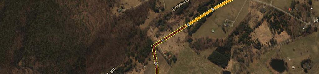
17 photograph that shows the Waldron orchard, which has approximately 1,000 living trees; and a topographic map labeled with locations of apple trees, properties historically associated with the apple industry, and properties associated with early Euro-American settlement of the area. Based on the additional information submitted in September, the Committee found the Bent Mountain Apple Orchard Rural Historic District NRHP-eligible at the local level of significance under Criterion A (Agriculture) and Criterion C (Architecture) with a period of significance of ca In a letter dated November 8, 2017, DHR recommended that: the FERC individually recognize [Bent Mountain Apple Orchard Rural Historic District] as an historic property and, as with the Bent Mountain RHD, find that the Bent Mountain Orchard RHD will be adversely affected by this undertaking. Mountain Valley accepted DHR s finding of an Adverse Effect on the Bent Mountain, Bent Mountain Apple Orchard, and Coles-Terry Rural Historic Districts and has proposed to mitigate that effect as detailed in this Treatment Plan. 2.0 DISTRICT SETTING AND ASSOCIATION 2.1 Bent Mountain and Bent Mountain Apple Orchard Rural Historic Districts Bent Mountain is a rural community established in the early nineteenth century after the initial settlement of Roanoke County. By the late nineteenth century, Bent Mountain was renowned for its apple orchards and other farm products that were transported to market in Roanoke down the Bent Mountain Turnpike, now U.S. Route 221. Today, Bent Mountain is characterized by its rural agricultural landscape that features late nineteenth- and early twentieth-century homes, barns, and other outbuildings, as well as well-preserved community buildings like the 1917 Bent Mountain School and 1947 Lawrence Memorial United Methodist Church. During Phase I survey, Mountain Valley s cultural resources consultant recommended additional architectural survey and background research in the Bent Mountain area of Roanoke County to evaluate its eligibility for listing in the NRHP as a rural historic district under Criteria A, C, and D (Figure 2.1). It comprises 42 potentially contributing resources buildings, structures, and farms made up of multiple buildings and structures as well as fields and other landscape features. Based on reconnaissance-level survey, Bent Mountain exhibits the physical characteristics of a rural historic district, including a concentration of buildings that are united historically by their geography, dates of construction, construction materials, and function. The proposed district covers a large area of valleys and ridges lying northwest of the BRP and partially overlaps with the Coles-Terry Rural Historic District and the BRP Historic District. Furthermore, DHR s National Register Evaluation Committee found on October 12, 2017, based on the available information, that the Bent Mountain Apple Orchard Rural Historic District has unique 8


18 Coles-Terry Rural Historic District Pending - Coles Terry's House Pending - Baker House Bent Mountain Apple Orchard Rural Historic District Mountain Valley Pipeline Project Proposed Route within the Bent Mountain and Bent Mountain Apple Orchard Rural Historic Districts Figure 2.1 December 2017 Data Sources: ESRI 2017, USGS Bent Mountain Rural Historic District ± Legend NAD 1983 UTM 17N Primary Contributing Historic Resource Limit of Disturbance Coles-Terry Rural Historic District Bent Mountain Rural Historic District Bent Mountain Apple Orchard Rural Historic District Blue Ridge Parkway Historic District Blue Ridge Parkway Historic District ; Miles Document Path: P:\EQT-Equitrans\MVP Project\GIS\Spatial\MXD\02_Cultural\ _VA_COE_Treatment_Plans_Historic_Districts\VA_COE_Treatment_Plan_HD_Boundaries_MasterListResources_BMHD_Topo.mxd
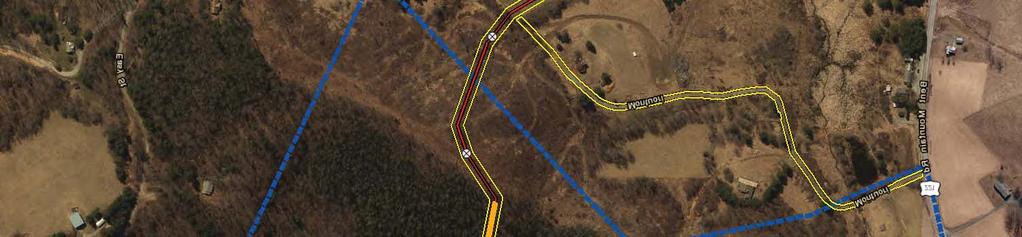
19 characteristics that warrant its individual recognition as a separate, distinctive district within the larger Bent Mountain Rural Historic District that encompasses it. 2.2 Coles-Terry Rural Historic District This approximately 2,500-acre historic district, partially overlapping the Bent Mountain Rural Historic District, lies on the eastern slope of Poor Mountain and includes the headwaters of Laurel Creek and Bottom Creek. It is mostly forested, and is owned today in its entirety by the Terry family. The district was identified subsequent to Mountain Valley s Phase I reconnaissance survey by its landowners and is assumed as NRHP-eligible under Criteria A, C, and D (Figure 2.2). To date, six contributing resources dating from the late nineteenth and early twentieth centuries have been identified including farm complexes, residences, cemeteries, and other structures. 3.0 DESCRIPTION OF MOUNTAIN VALLEY AS IT AFFECTS PROPERTY SETTING AND ASSOCIATION Mountain Valley proposes to cross the Bent Mountain Rural Historic District at approximate milepost 242 of the Project, for a distance of 24,010 feet, or 4.6 miles; the Bent Mountain Apple Orchard Rural Historic District at approximate milepost of the Project, for a distance of 9,901feet, or 1.88 miles; and the Coles-Terry Rural Historic District at approximate milepost 240 of the Project, for a distance of 15,480 feet, or 2.93 miles. Construction of the belowground pipeline will include short-term, long-term, and permanent impacts on the existing vegetation cover types. 4 Effects related to vegetation removal within the rural historic landscape were among several issues that were the focus of consultation discussions with DHR and stakeholders. When feasible, Project design plans have been modified in response to issues raised in public forums, Project correspondence, and docket filings. Avoidance plans related to specific properties within the district are provided as Attachment 1. These plans were developed by Mountain Valley to avoid direct impacts on contributing historic properties and were approved by the DHR in a letter dated July 7, Subsequently, in a letter dated September 21, 2017, DHR found that construction of a new roadway and permanent workspace so close to the Henry-Waldron Cemetery ( ), a contributing resource to the Coles-Terry Rural Historic District, is inconsistent with its rural character and will greatly alter the property s setting and feeling (Attachment 2). DHR concluded that the pipeline Project will adversely affect the Henry-Waldron Cemetery. Mountain Valley responded to DHR in a letter dated January 17, 2018, explaining that Mountain Valley proposes to utilize an existing 8-foot-wide dirt road running along the northwestern boundary of the Henry-Waldron Cemetery to create a permanent 8-foot-wide access road surfaced with gravel. Mountain Valley clarified that it does not intend to construct a new roadway as indicated in DHR s letter and that in order to minimize impacts on the cemetery, Mountain Valley 4 No aboveground Project facilities are proposed within the recommended NRHP boundaries for the Bent Mountain, Bent Mountain Apple Orchard, and Coles-Terry Rural Historic Districts. 10


20 Mountain Valley Pipeline Project Proposed Route within the Coles-Terry Rural Historic District Figure 2.2 December 2017 Data Sources: ESRI 2017, USGS ± Legend NAD 1983 UTM 17N Pending - Fire Tower Primary Contributing Historic Resource Limit of Disturbance Coles-Terry Rural Historic District Bent Mountain Rural Historic District Coles-Terry Rural Historic District Bent Mountain Apple Orchard Rural Historic District Bent Mountain Apple Orchard Rural Historic District Pending - Baker House Bent Mountain Rural Historic District Pending - Coles Terry's House Miles Document Path: P:\EQT-Equitrans\MVP Project\GIS\Spatial\MXD\02_Cultural\ _VA_COE_Treatment_Plans_Historic_Districts\VA_COE_Treatment_Plan_HD_Boundaries_MasterListResources_CTRHD_Topo.mxd
21 proposed to narrow the limits of disturbance (LOD) to provide an approximately 11-foot-wide buffer between the cemetery and the LOD. 5 This will be accomplished by reducing the access road LOD from the standard 50 feet to 25 feet in width while passing the cemetery to avoid direct impacts (the road will not cross the Henry-Waldron Cemetery s historic property boundary) and to minimize indirect impacts. Furthermore, protective fencing will be installed along the cemetery s northeastern boundary along the access road LOD. The southwestern edge of the road will be constructed at least 11 feet from the Henry-Waldron Cemetery s historic property boundary. Following construction, the road width will be reduced to 8 feet and the permanent road will follow the route of the extant historic-era dirt road. Access to the cemetery will be maintained during construction. The revised avoidance plan for the cemetery is included in Attachment 1. Mountain Valley and DHR discussed the revised approach to the access road in telephone calls on December 29, 2017 and January 3, DHR indicated that it was likely, following review of the new avoidance plan, that the recommendation for the road would be changed from an adverse impact to a no adverse impact. To date, FERC and Mountain Valley have not received a DHR letter with its findings responding to the Mountain Valley January 17, 2018, letter. Under Stipulation IV.A of the executed Programmatic Agreement for the Project, If timely comments are not received from any party during the review period [30 calendar days], FERC shall proceed based on review and consideration of timely comments received from other parties. No comments from other parties have been filed on the docket to date. Of the 24,010 feet of the Project within the Bent Mountain Rural Historic District, the 9,901 feet within the Bent Mountain Apple Orchard Rural Historic District, and the 15,480 feet within the Coles-Terry Rural Historic District, only a few segments, crossing roadways and residential yards, are located in areas that are accessible or visible to the public, or visible from a primary contributing historic resource. Vegetation removal for Mountain Valley has been minimized to the greatest practicable extent. However, as DHR concluded, project-related disturbances resulting from incompatible land use practices or resulting in the physical removal of vegetation within the rural historic landscape will affect the aspects of integrity of setting, feeling, and association for the Bent Mountain, Bent Mountain Apple Orchard, and Coles-Terry Rural Historic Districts and, as a result, requires treatment. 4.0 MITIGATION OF ADVERSE EFFECTS IDENTIFIED 4.1 Approach to the Development of Mitigation Mountain Valley s selection of appropriate mitigation is guided by three principles: it should (1) have a nexus to the identified adverse effects of the proposed action, (2) be proportional to those effects, and (3) take consideration of the input of consulting parties and local stakeholders. The adverse effect to be mitigated for the Bent Mountain, Bent Mountain Apple Orchard, and Coles- 5 To avoid confusion, it should be understood that the LOD is the area in which disturbance is authorized by FERC, and it is not necessarily reflective of the width of the road that will be utilized or the area that will in fact be disturbed. For new or improved access roads, the disturbed area typically is less than the full LOD. 12
22 Terry Rural Historical Districts is, according to DHR, the diminution in the very agrarian setting and feeling of the district resulting from the permanent fifty-foot wide imprint on [its] landscape. To further clarify this effect and assess its magnitude, it is important to note that DHR specifically states that this effect does not arise from visual impacts on the landscape in the districts. Aboveground impacts from this buried natural gas pipeline will be largely imperceptible following the restoration of the right-of-way with the exception of the portions of the permanent right-of-way situated in currently forested areas, which will be periodically cleared of woody vegetation to protect the integrity of the pipeline. Permanent impacts on the portions of the landscape not devoted to agriculture, and not in forest (e.g., meadows), will be avoided and/or minimized by the restoration of the pre-existing contours of the temporary and permanent rights-of-way and revegetation with native seed mixes. Permanent impacts on agricultural lands will be avoided and/or minimized by allowing the right-of-way to return to previous agricultural use following Project construction. For the Bent Mountain Rural Historic District, this results in approximately 8,733 feet (or 36 percent) of impacts that will either be avoided or restored. For the Bent Mountain Apple Orchard Rural Historic District, this results in approximately 3,663 feet (or 37 percent). The implication of these measures for the Coles-Terry Rural Historic District is the avoidance or restoration of approximately 2,100 feet (or 14 percent) of impacts. Lastly, there will be no aboveground Project facilities placed on the landscape within any of the districts. In light of the largely temporary impacts on the physical landscape in non-forested areas and the measures to minimize the visibility of the right-of-way in forested areas, additional changes to Project construction or restoration practices will only minimize, not effectively ameliorate, the adverse effect identified by DHR on the agrarian feeling and setting of the districts. As a result, Mountain Valley has identified a combination of minimization and mitigation measures enhanced treatment of the permanent right-of-way within the historic districts, preparation of a PIF for the Bent Mountain Rural Historic District and NRHP nominations for the Bent Mountain Apple Orchard and Coles-Terry Rural Historic Districts, and a building restoration and preservation fund that will directly address the potential adverse effect identified by DHR to the feeling of the area for its residents and visitors and will preserve the historic and cultural significance of the districts. This approach is proportional to the minimal long-term physical adverse effect to the districts. It also is responsive to feedback Mountain Valley received from consulting parties and stakeholders. 4.2 Consultation with Consulting Parties and Other Stakeholders The DHR recommended that Mountain Valley assist the FERC with outreach to consulting parties and other interested stakeholders (including Preserve Roanoke, the Committee for Appalachian and Piedmont Preservation, Preservation Virginia, Historical Society of Western Virginia, and the Roanoke Valley Preservation Foundation) to identify appropriate mitigation measures for the adverse impacts on the Bent Mountain and Coles-Terry Rural Historic Districts. As there is no steering committee for either of the districts, Mountain Valley contacted representatives of Preserve Roanoke and the Committee for Appalachian and Piedmont Preservation. On behalf of 13
23 both of these organizations, Ann Rogers declined to meet with Mountain Valley to discuss potential mitigation strategies. Mountain Valley prepared its original proposed Treatment Plan for the historic districts in August The Treatment Plan was circulated to relevant consulting parties and other interested stakeholders for comment on or around August 28, 2017, including: Ann Rogers (Preserve Roanoke and the Committee for Appalachian and Piedmont Preservation) Sonja Ingram, Preservation Virginia Ashley Webb, Historical Society of Western Virginia Richard Caywood, Roanoke County Board of Supervisors Alison Blanton, Roanoke Valley Preservation Foundation Roger Kirchen, DHR In a letter dated September 9, 2017, Ms. Rogers proposed that the Treatment Plan be revised to include a nomination for the Bent Mountain Apple Orchard Rural Historic District. On November 3, 2017, representatives from Roanoke County, DHR, Ms. Rogers, and Mountain Valley held a conference call to discuss the proposed Treatment Plan. Mr. Caywood, for Roanoke County, indicated that the county did not have specific comments on the proposed mitigation plan but he did discuss concerns related to the specific pipeline route and the consideration of route alternatives as it related to the potential historic districts. Mr. Kirchen from the DHR provided information related to the Bent Mountain Apple Orchard Rural Historic District and indicated that his office would be providing additional information in a forthcoming letter. Mountain Valley prepared a revised Treatment Plan based on the feedback received from Ms. Rogers and DHR in December The Treatment Plan was circulated to the same consulting parties and other interested stakeholders as listed above for comment on or around December 20, Subsequently, FERC granted consulting party status to landowners Grace Terry, Elizabeth Terry Reynolds, Frank Terry, and John Coles Terry in January Mountain Valley provided a copy of the December 2017 Treatment Plan to the Terry family on or around January 5, Attachment 2 includes copies of minutes, correspondence, letters, and other documents referenced in Section 4.2. DHR DHR provided general comments on the draft Mountain Valley treatment plans (August 2017) in a letter dated November 3, In that letter, DHR suggested that the treatment of the historic districts would benefit from the input of consulting parties. DHR noted that it previously discussed with Mountain Valley the possibility of constricting the maintained pipeline right-of-way as it crosses historic properties, and especially at public roads within historic districts, to minimize the 14
24 visibility of the pipeline from public spaces. DHR encouraged the FERC to work with the consulting parties to consider such an effort to minimize impacts. DHR provided additional comments on the draft Treatment Plan in a letter dated November 8, In that letter DHR supported the preparation of nominations to the NRHP for the Bent Mountain Apple Orchard and Coles-Terry Rural Historic Districts and the preparation of a PIF, which is a precursor to a NRHP nomination in Virginia, for the Bent Mountain Rural Historic District. DHR recommended that the PIF for the Bent Mountain Rural Historic District will allow for the refinement of boundaries for the Bent Mountain Apple Orchard and Coles-Terry Rural Historic Districts through the development of a historic context for the Bent Mountain Rural Historic District. In a letter dated November 17, 2017, addressed to the FERC, the NPS - BRP concurred with DHR that preparation of a PIF for the Bent Mountain Rural Historic District will help mitigate the adverse effect. The revisions requested by Ms. Rogers, DHR, and NPS are reflected in Section 4.3. Roanoke County In a letter dated January 4, 2018, Roanoke County staff provided comments on the draft Treatment Plan that included proposed reforestation within the district similar to Mountain Valley s restoration and revegetation plan for the Jefferson National Forest. Mountain Valley contacted Roanoke County Attorney Ruth Ellen Kuhnel and held meetings by teleconference on February 5, and February 7, and February 8, 2018, with Ms. Kuhnel and Mr. Caywood to discuss Roanoke County s comments on the proposed Treatment Plan for Bent Mountain, Bent Mountain Apple Orchard, and Coles-Terry Rural Historic Districts, which were outlined in a letter to the FERC docket dated January 4, 2018 (filed jointly with Giles County), as well as other relevant issues the county wished to address. Sections captures an overview of the teleconference discussions and responses to other issues raised in the January 4, 2018, letter Mitigation Fund During the February 6, 2018, teleconference, in response to the request in Roanoke County s letter for the establishment of a mitigation fund, Mountain Valley provided an overview of a historic resource mitigation agreement entered into between Mountain Valley and the Commonwealth of Virginia. Mountain Valley explained that the agreement obligates Mountain Valley to expend at least $1.5 million on historic resources mitigation and to fund the creation of a $1 million mitigation fund for the purpose of providing grants for the preservation of historic resources within the vicinity of the Project. 6 Mountain Valley clarified that the fund, to be managed by the Virginia Historical Society (VHS), predated the consulting parties request for a mitigation fund and that it 6 Section 3.a of the agreement, which can be found in Attachment 2, states: The Mitigation Fund shall operate as an endowment for grant-making purposes to document, preserve, and interpret the historic resources within the Commonwealth s localities affected by the Project. The Commonwealth shall work with [Virginia Historical Society] and determine project selection criteria and a process for evaluating appropriate projects that are consistent with DHR historic resources mitigation standards. 15
25 is relevant to, but not a substitute for, the preparation of treatment plans or discussion of other possible compensatory mitigation measures. Mountain Valley further noted that there was a separate mitigation agreement to provide compensatory mitigation for impacts on forests and water quality Reduction of the Maintained Permanent Easement Mountain Valley explained the measures developed with the US Forest Service to introduce undulations and reductions in the maintained area of the right-of-way to reduce visual impacts and noted that Mountain Valley was reviewing possible locations to implement similar measures in the vicinity of the Bent Mountain, Bent Mountain Apple Orchard, and Coles-Terry Rural Historic Districts. Mountain Valley presented an overview of the areas Mountain Valley had targeted for enhanced right-of-way treatment, which were developed in response to the requests of the various parties for right-of-way treatments similar to those employed on US Forest Service land. Mountain Valley asked if the parties had additional areas that would like to see the enhanced treatment. Roanoke County staff requested that additional consideration be given to potential views of the Project as it crosses the upper part of the eastern slope of Poor Mountain. Mountain Valley indicated in the calls that it would evaluate whether additional enhanced right-of-way treatment would be beneficial Mislocation/Misidentification of Historic Resources Mountain Valley stated that relevant information was provided to DHR and consulting parties and that DHR provided concurrence on Mountain Valley s Criteria of Effects Report. As requested by DHR s July 7, 2017, comment letter on the Criteria of Effects Report, Mountain Valley also provided additional information to DHR and consulting parties, and to date, DHR had not requested any additional information regarding this issue Historic Private Water Supplies Mountain Valley provided an overview of the Water Resources Identification and Testing Plan (Plan) and the related conditions in the Virginia State Water Control Board s Supplemental 401 Certification (Certification). Mountain Valley noted that it has two full-time hydrogeologists leading Mountain Valley s water source protection program to whom landowners may be directed to provide information about the identification of private water sources Pipeline Class Mountain Valley provided a summary of the applicable federal Pipeline and Hazardous Materials Safety Administration (PHMSA) safety requirements that applied to the pipeline and explained that the pipe through Roanoke County will meet or exceed all federal regulations. 7 Shortly after the call, Mountain Valley s consultant evaluated potential views of the Project (as it crosses the upper part of the eastern slope of Poor Mountain) from key travel routes within the Coles-Terry Rural Historic District and has proposed an additional treatment area within the district, milepost (as shown in Table in below). This results in an additional 0.3 miles of enhanced right-of-way treatment, which is reflected in Section
26 Historic Agricultural Properties Mountain Valley explained that landowners are contacted directly on a case-by-case basis to ensure that the existing agricultural practices can continue and that the pipeline is designed to handle heavy equipment up to certain weight limits Indemnification Mountain Valley stated that there were overlapping federal and state agencies with authority to ensure that Mountain Valley addressed any damage from the Project Restricted Use of Permanent Easement for Future Pipelines Mountain Valley explained that it cannot restrict the authority of the FERC or other regulatory agencies to permit or deny the co-location of future utilities within or without the existing rightof-way in the future. Any future pipelines, whether or not they share an existing right-of-way, would have to go through the process of obtaining all necessary federal and state approvals. In addition, it is noted that additional lines cannot be placed within easements on properties where the easements are obtained through the condemnation process. Follow Up Consultation with DHR On Friday, February 9, 2018, John Centofanti of MVP had a telephone conversation with Roger Kirchen of Virginia DHR. Mr. Centofanti described the proposal to create a fund for the preservation of a selected historic structure. Mr. Kirchen expressed that he could support such a project as an element of a revised Treatment Plan but suggested that conditions be placed in the plan to afford DHR an ongoing consultation role to ensure the repairs are appropriate and do not cause adverse effects to this historical resource. Additional changes were made to this Treatment Plan (Section and Attachment 3) in response to Mr. Kirchen s input. ACHP In a letter to the FERC dated January 18, 2018, the Advisory Council on Historic Preservation (ACHP) provided general observations regarding the resolution of adverse effects as proposed in the draft treatment plans based on its review of the plans and the comments submitted to the ACHP for its consideration. Specifically, the ACHP reiterated the request from consulting parties and stakeholders that the FERC require Mountain Valley to follow practices similar to those required by the US Forest Service in the Jefferson National Forest to reduce the distinctive appearance of the right-of-way in high visibility areas in and near the affected historic districts. Furthermore, the ACHP restated the requests of consulting parties and stakeholders to: 1) maintain the agricultural, grazing, and tree harvesting uses along the right-of-way where they currently exist and are recognized as important characteristics of affected historic districts; 2) consider working with local officials to establish financial resources to assist in preserving the rural historic character of the historic districts; and 3) explore how future collocation of additional natural gas pipelines in the right-of-way can be avoided to preserve the existing setting of the historic districts. 17
27 Incorporation of Consulting Parties Suggestions into Treatment Plan This Treatment Plan has been substantially revised in response to the feedback received from Ms. Rogers (Preserve Roanoke), DHR, the ACHP, and Roanoke County on the August and December 2017 versions of the plan. Those parties suggestions have been incorporated into this revised Treatment Plan and are reflected in Sections through Several of the proposed mitigation options discussed with consulting parties were not incorporated into this proposed minimization and mitigation plan. Mountain Valley has not proposed to create a general mitigation fund. Instead, Mountain Valley has proposed supplemental compensatory mitigation to assist local stakeholders in addressing needs, identified during consultations, related to specific contributing resources which predate and are unrelated to any impacts from the Project. While Mountain Valley is sympathetic to the sincere concerns expressed by consulting parties, the justifications presented for a mitigation fund are unrelated to the specific adverse effect to the district identified by DHR and are not in the nature of effects to resources that are mitigated under Section 106. Additionally, the funds proposed in this Treatment Plan can be augmented by applications for grants from the existing mitigation fund created by the Commonwealth and administered by VHS for this purpose. Mountain Valley does not propose to further upgrade the pipeline classification within the district. For example, approximately 88% of the route through Roanoke County requires only PHMSA Class 1 pipe; however, approximately 97% of the pipe through Roanoke County will be either Class 2 (92.5%) or Class 3 (4.7%). The pipeline class within the district already meets or exceeds the standard required by the federal safety regulations, and increasing the pipeline class further does not mitigate the adverse effects identified by DHR. Additional water supply protections and agricultural land use preservation measures have not been included because the consulting parties requests can be met through existing plans, practices, and regulatory requirements. Lastly, Mountain Valley cannot restrict the authority of the FERC or other regulatory agencies to permit or deny the co-location of future utilities within or without the existing right-of-way in the future. It also is worth noting that the FERC evaluated an alternative in its Environmental Impact Statement involving the co-location of a second pipeline within Mountain Valley s right-of-way. FERC concluded that this scenario likely is technically infeasible. 8 In addition, it is noted that additional lines cannot be placed within easements on properties where the easements are obtained through the condemnation process. Proposed Mitigation Plan In a letter dated November 3, 2017, DHR encouraged the FERC to work with the consulting parties to consider the possibility of constricting the maintained pipeline right-of-way as it crosses historic properties, and especially public roads within historic districts. In a letter to the FERC dated January 18, 2018, the ACHP reiterated a similar request from consulting parties and stakeholders that the FERC require Mountain Valley to follow practices similar to those required 8 Certificate
28 by the US Forest Service in the Jefferson National Forest to reduce the distinctive appearance of the right-of-way in high visibility areas in and near the affected historic districts. Enhanced Right-of-Way Treatment to Reduce Visibility of Permanently Maintained Corridor Mountain Valley s proposed minimization plan to address potential adverse effects focuses on further reducing the visibility of the maintained permanent right-of-way from locations with potential visibility within the districts including high visibility areas such as main arterial roadways a primary concern expressed by DHR and the ACHP. Mountain Valley conducted a thorough desktop analysis, using information about the Project alignment, topography, and existing vegetation, to identify route segments that will be considered for enhanced right-of-way treatment. Mountain Valley applied the following three criteria to identify segments for further consideration: (a) location within the historic district boundary; (b) expected to be visible from likely viewing locations within that historic district; and (c) located within forested areas (as mapped in the National Land Cover Database and/or shown in recent aerial imagery), and therefore likely to result in relatively higher contrast following construction without restoration of the right-of-way. Mountain Valley will implement the following mitigation measures to lower potential visual impacts from the Project identified during the analysis. Within the following route segments, depicted in Figures through , Mountain Valley will revegetate the right-of-way to ensure that vegetative openings appear more natural and conform to the natural form, line, color, and texture of the existing landscape. Bent Mountain Rural Historic District (See Figure ) Segment Milepost Range Length (feet) Mileage , , Total 3, Bent Mountain Apple Orchard Rural Historic District (See Figure ) Segment Milepost Range Length (feet) Mileage , Total 1, Coles-Terry Rural Historic District (See Figure ) Segment Milepost Range Length (feet) Mileage , , Total 5,


29 Document Path: R:\PROJECTS\MOUNTAIN_VALLEY_PIPELINE_5107\HISTORIC_DISTRICT_VIEWSHEDS\MAPS\BENT_MT_ROW.mxd ± :8, NAD 1983 UTM 17N 243 Bent Mountain Rural Historic District Bent Mountain Apple Orchard Rural Historic District ,000 1,500 2,000 Feet Mountain Valley Pipeline Project Figure Proposed Enhanced ROW Treatment Areas within Bent Mountain Rural Historic District Segments 1 and 2 JANUARY 2018 Legend!? Milepost Reduction in the Maintenance of the Permanent ROW to 10ft Issued for Construction Route Permanent ROW Bent Mountain Historic District (Proposed by MVP Cultural Team) Bent Mountain Apple Orchard Rural Historic District Bent Mountain Rural Historic District Data Sources: VDHR, USGS, ESRI


30 Document Path: R:\PROJECTS\MOUNTAIN_VALLEY_PIPELINE_5107\HISTORIC_DISTRICT_VIEWSHEDS\MAPS\BENT_MT_APPLE_ORCHARD_ROW.mxd ± 1:6, Bent Mountain Apple Orchard Rural Historic District NAD 1983 UTM 17N ,200 1,600 Feet Mountain Valley Pipeline Project Figure Proposed Enhanced ROW Treatment Area within Bent Mountain Apple Orchard Rural Historic District Segment 1 JANUARY 2018 Legend!? Milepost Reduction in the Maintenance of the Permanent ROW to 10ft Issued for Construction Route Permanent ROW Bent Mountain Apple Orchard Rural Historic District Bent Mountain Apple Orchard Rural Historic District Data Sources: VDHR, USGS, ESRI


31 Document Path: R:\PROJECTS\MOUNTAIN_VALLEY_PIPELINE_5107\HISTORIC_DISTRICT_VIEWSHEDS\MAPS\COLES_TERRY_ROW.mxd ± :10, Coles-Terry Rural Historic District NAD 1983 UTM 17N ,200 1,600 Feet Mountain Valley Pipeline Project Figure Proposed Enhanced ROW Treatment Areas within Coles-Terry Rural Historic District Segments 1, 2, & 3 JANUARY 2018 Legend!? Milepost Reduction in the Maintenance of the Permanent ROW to 10ft Issued for Construction Route Permanent ROW Coles-Terry Rural Historic District Coles-Terry Rural Historic District Data Sources: VDHR, USGS, ESRI
32 Mountain Valley will revegetate the construction and permanent operational right-of-way as shown in the concept diagram provided in Figure This entails maintaining an herbaceous strip 10-foot-wide centered over the pipeline (reduced from the typical 50-foot width), and performing trimming or selective cutting of trees over 15 feet in height within a 30-foot-wide strip centered over pipeline. Outside the 10-foot-wide strip, the remainder of the construction and permanent right-of-way would be revegetated through the use of acceptable seed mixes, pollinator plants, shrubs and trees in accordance with FERC Plan and Procedures (FERC Plan) and consistent with DEQ s approval. 9 Particularly along the edge of this herbaceous linear opening, a variety of sizes and species of vegetation would be planted in a manner that breaks up the straight, parallel edges of the corridor and reduces the hard shadow line that can draw the viewer s attention. This enhanced right-of-way treatment would reduce the visual contrast and the potential indirect visual effects within the Bent Mountain, Bent Mountain Apple Orchard, and Coles-Terry Rural Historic Districts. PIF for the Bent Mountain Rural Historic District and NRHP Nominations for the Bent Mountain Apple Orchard and Coles-Terry Rural Historic Districts Stakeholders have noted the presence of additional historic architectural and natural resources that, in their opinion, may potentially serve as contributing resources to the districts. Mountain Valley s proposed mitigation plan to address potential adverse effects is to fund the preparation of a PIF for the Bent Mountain Rural Historic District and NRHP nominations for the Bent Mountain Apple Orchard and Coles-Terry Rural Historic Districts by a qualified historian or architectural historian meeting the Secretary of the Interior s Professional Qualification Standards. Assuming that access to all properties within the Bent Mountain Apple Orchard and Coles-Terry Rural Historic Districts is obtained, the nomination process will ensure that all contributing and non-contributing objects, sites, structures, buildings, landscape features (natural and built), etc. will be inventoried through intensive-level documentation and research. Furthermore, the process will allow each of these two districts to be designated as a NRHP-listed historic district. This designation will enable Roanoke County to preserve its character through historic preservation programs. Historic preservation programs, used as an economic development tool, will enable Roanoke County to take advantage of its history and, in combination with the county s other NRHP-listed historic districts, further develop a tourism market. As there is no committee or point of contact specific to the districts, Mountain Valley will afford Preservation Virginia and the Committee for Appalachian and Piedmont Preservation the opportunity to, individually or collectively, choose the qualified professional (provided the professional meets the Secretary of the Interior s Professional Qualification Standards and charges commercially reasonable rates and costs), administer the funds, and manage the qualified professional and deliverables. If an outside organization manages the implementation of the 9 The FERC Plan and Procedures comprise construction best management practice standards that the FERC first introduced in The FERC has encouraged natural gas pipeline companies to adopt these documents into their applications to the FERC and commit to these standards in construction for new pipelines and maintenance on existing pipelines. 23

33 Figure Proposed ROW Revegetation Concept for Enhanced Treatment Areas within Bent Mountain, Bent Mountain Apple Orchard, and Coles-Terry Rural Historic Districts
34 mitigation plan, it will adhere to all requirements of this document. If these organizations decline to serve in this capacity, Mountain Valley will assume these responsibilities. Mountain Valley will work with the DHR to finalize the scope for the measures outlined in Section 4.3.2; however, Mountain Valley assumes that the qualified professional will prepare a PIF for the Bent Mountain Rural Historic District and NRHP nominations for the remaining two rural historic districts following all NRHP guidelines and requirements. For the Bent Mountain Apple Orchard and Coles-Terry Rural Historic Districts, the qualified professional, in consultation with DHR, will: 1. Review existing survey, historical research, publications, and architectural traditions; 2. Propose an approximate Period of Significance and Boundary; 3. Produce narrative justification for recommended Period of Significance, narrative justification for recommended boundary, supporting documentation including mapping depicting the recommended boundary, photographs, and major bibliographical references used to determine the recommended boundary; 4. Prepare draft NRHP Nomination (although not anticipated, a second draft submission may be required at the discretion of the DHR, if warranted due to substantive comments); 5. Prepare final NRHP Nomination subsequent to DHR review of the draft NRHP nomination: three (3) hard copies and one (1) digital copy (Microsoft Office Word format) of the completed final nomination forms and all accompanying material (in appropriate formats); 6. Prepare 2 sets of address labels for all current property owners within the proposed NRHP historic district at the time of submission for use by the DHR in nomination-related correspondence. Preservation and Restoration of the Bent Mountain Center In the January 4, 2018, letter to the FERC docket, Roanoke County emphasized the importance of the Bent Mountain Center (formerly Bent Mountain Elementary School ) as an important cultural resource within the Bent Mountain Rural Historic District. In discussions with Roanoke County on February 5, February 7, and February 8, 2018, the county reiterated the need for funding to preserve and restore this historic resource and expressed its view that additional compensatory mitigation should be provided in the Treatment Plan. As a result of these consultations, and for the purpose of providing supplemental compensatory mitigation for the identified adverse effect on the district, this Treatment Plan has been revised to include the establishment of a $500,000 Bent Mountain Center Preservation Fund (Fund) dedicated to the preservation and restoration of the Bent Mountain Center (formerly Bent Mountain Elementary School) (contributing resource ). The Fund shall be administered by the Roanoke County Board of Supervisors in continuing consultation with DHR. Its use will be subject to the Terms and Conditions set forth in Attachment 3, which ensure that the moneys are 25
35 used for valid mitigation purposes consistent with this Treatment Plan and the requirements and objectives of the NHPA. The moneys ($500,000) to establish the Fund shall be provided by Mountain Valley to the Roanoke County Board of Supervisors within 30 days of the later of the following: (i) the commencement of land disturbance within the District or (ii) the date of Roanoke County s execution of the attached Terms and Conditions. The Fund, in concert with the various avoidance, minimization, and compensation measures identified in this Treatment Plan, rounds out a robust suite of mitigation measures that fully addresses the need to mitigate the adverse effects to the district identified by DHR. 5.0 SCHEDULE Mountain Valley will implement this Treatment Plan concurrent with construction activities within the district. Within two months of issuance of the approved Treatment Plan, Mountain Valley will develop and submit a final scope of work for the PIF and NRHP Nominations to the DHR for review and approval. The final scope of work will be implemented accordingly (as outlined in Section 4.3 above) and all activities related to the Treatment Plan to be completed by Mountain Valley, except for ongoing monitoring and maintenance of the enhanced right-of-way treatment, will be completed within one year of the date of service for the Mountain Valley Pipeline Project. 26
36 ATTACHMENT 1 AVOIDANCE PLANS


37 245.5 Document Path: P:\EQT-Equitrans\MVP Project\GIS\Spatial\MXD\02_Cultural\ _VA_COE_Avoidance_Rev5_1_19\VA_COE_HistoricArchit_AvoidancePlans_ _CLEAN.mxd Cabin Primary Contributing A, C Distance to LOD: 68.9ft Access to property to be maintained during construction MVP-RO-287 Mountain Valley Pipeline Project NAD 1983 UTM 17N Feet Legend Avoided Historical Architectural Resource Avoidance Plan 20 Site: Cabin Roanoke County, Virginia Milepost Proposed Route Access Road Proposed Limits of Disturbance Direct APE Permanent Easement Roanoke Franklin April 2017 Temporary Impact Data Sources: USGS, ESRI, Open Street Map.


 Roanoke County, VA")
38 MVP-RO-281 MVP-ATWS-1226 Temporary Limits of Disturbance for access road will be reduced to 25-feet-wide for the access road during construction. Add Protective Fencing Document Path: P:\EQT-Equitrans\MVP Project\GIS\Spatial\MXD\02_Cultural\ Avoidance_Treatment_Plans\ _Implementation_Route_Avoidance_Plans\VA_AvoidancePlan_Implementation_Route_ mxd 241.5!C MVP-RO MVP-RO Henry-Waldron Cemetery 241.6!C 1990s Hay Barn Milking Parlor Springhouse 241.7!C Chicken Coop Root Cellar House Elijah Henry House 241.8!C Mountain Valley Pipeline Project Revised Avoidance Plan for Henry-Waldron Cemetery ( ) Roanoke County, VA DECEMBER 2017 Data Sources: USGS, ESRI, Open Street Map. ± NAD 1983 UTM 17N Legend Historic Property Boundary Historic Structure Modern Structure Protective Fencing Construction Limits of Disturbance!C Milepost Proposed Pipeline Route Proposed Access Road Feet Montgomery Roanoke Franklin
39 ATTACHMENT 2 CORRESPONDENCE
40 From: To: Cc: Subject: Date: Ann M Rogers Neylon, Megan Kirchen Roger (DHR); Elizabeth Merritt; John Eddins; David Brady; Andrea Ferster; Bert Bondurant; Bonnie Law; Julie Gantenbein; Richard Caywood; Ruth Ellen Kuhnel Re: Mountain Valley Pipeline Meeting Thursday, July 27, :15:10 PM Megan, I do apologize for taking so long to respond to your invitation to meet to discuss the Mountain Valley Pipeline's impacts to the Bent Mountain and Coles-Terry Rural Historic Districts. I agree with and wholeheartedly endorse the Virginia SHPO's finding of adverse effects on five historic districts in the proposed route of the MVP. Please refer to the SHPO's letter to you dated However, after consultation with various stakeholders who have an interest in the Mountain Valley Pipeline's impacts to historic resources including the Bent Mountain, Coles-Terry, and Blue Ridge Parkway Historic Districts, and other MVPaffected historic resources, I have concluded that until MVP is able to correct the serious flaws in its May 10 cultural resources filing, as discussed in my filing to FERC sent in behalf of Preserve Roanoke on July 12, it is pointless to discuss mitigation. MVP has not yet offered a reasonable assessment of impacts, which is a necessary precursor to discussion of mitigation. Thank you for contacting me. Ann Rogers Preserve Roanoke From: "Neylon, Megan" <MNeylon@eqt.com> To: "Amelvin3@verizon.net" <Amelvin3@verizon.net> Sent: Monday, July 24, :20 PM Subject: Mountain Valley Pipeline Meeting Hi Ann, Per our conversation on Friday July 21, 2017, Mountain Valley Pipeline is trying to set a meeting with you and any other stakeholders interested in the Bent Mountain and Coles-Terry Historic Districts. Mountain Valley is considering adding the following people to the invite list. If there are any additional people that you think should attend, please let me know. Ashley Webb The Historical Society of Western Virginia Alison Blanton Roanoke Valley Preservation Sonja Ingram Preserve Virginia We would like to have this meeting as soon as possible. We will be in the area on Thursday 7/27/17 as you know to
41 meet with Big Stony Historic District. If we could make it work, Mountain Valley could meet with you and others interesed in Coles-Terry and Bent Mountain Historic Districts later in the afternoon on Thursday. Thank you, Megan E. Neylon Supervisor - Permitting Office: MNeylon@eqt.com
42 From: To: Subject: Date: Anita Puckett Neylon, Megan Re: North Fork Valley Rural Historic District Tuesday, August 01, :16:45 PM Sorry, Megan. Our stance is one that no mitigation is possible. MVP needs to move outside the entire District. There's no point in meeting. Anita On Tue, Aug 1, 2017 at 11:16 AM, Neylon, Megan wrote: Anita, Elizabeth (Betty) Hahn sent an to Mountain Valley on July 26, 2017 stating that she has spoken to people interested in the North Fork Valley Rural Historic District and that they decline a meeting with Mountain Valley. Based on your below, I wanted to reach out to you to see if you would still like to meet. If you would still be interested in meeting with Mountain Valley, I would like to set up a date and time. Please feel free to give me a call to discuss. Thank you, Megan E. Neylon Supervisor - Permitting Office: MNeylon@eqt.com From: Anita Puckett [mailto:anitampuckett@gmail.com] Sent: Tuesday, July 25, :00 AM To: Neylon, Megan <MNeylon@eqt.com>; Seriff, David <fires1957@yahoo.com>; Ann M Rogers <amelvin3@verizon.net> Subject: North Fork Valley Rural Historic District Dear Ms. Neylon, A short message to let you know that I'm a representative of Preserve Montgomery who is
43 meet with Big Stony Historic District. If we could make it work, Mountain Valley could meet with you and others interesed in Coles-Terry and Bent Mountain Historic Districts later in the afternoon on Thursday. Thank you, Megan E. Neylon Supervisor - Permitting Office: MNeylon@eqt.com
44 S e p t e mb e r 1 9, Ms. Me g a n N e y l o n E n v i r o n me n t a l P e r mi t t i n g S u p e r v i s o r Mo u n t a i n V a l l e y P i p e l i n e S o u t h p o i n t e B o u l e v a r d C a n n o n s b u r g, P A D e a r Ms. N e y l o n, T h a n k y o u f o r y o u r l e t t e r o f A u g u s t 2 5, f o r w a t h e B e n t Mo u n t a i n R u r a l H i s t o r i c D i s t r i c t ( ) p r e p a r e d b y T e t r a T e c h f o r Mo u n t a i n V a l l e y r e s p o n s e. Response to analysis within HISTORIC PROPERTY TREATMENT PLAN, SECTION 1.2 Project Effect I n S e c t i o n 1. 2 o f t h e T r e a t me n t P l a n, T e t r a T e c h A s n o t e d i n S e c t i o n 3. 2 a n d 4. 1 o f Mo u n t a i n V a h i s t o r i c l a n d s c a p e s ma y a l s o q u a l i f y a s a T r a d N a t i o n a l P a r k S e r v i c e s G u i d e l i n e s f o r E v a l u a t P r o p e r t i e s, i f t h e l a n d s c a p e s o r g a n i z a t i o n, r e f l e c t t h e c u l t u r a l t r a d i t i o n s v a l u e d b y i t s w h e r e a c o mmu n i t y h a s t r a d i t i o n a l l y c a r r i e d o i mp o r t a n t i n ma i n t a i n i n g i t s h i s t o r i c i d e n t i t y a T C P h i n g e s o n h o w t h e s i t e s, s t r u c t u r e s, b u i e l e me n t s a r e u s e d b y me mb e r s o f t h e c o mmu n i t y. e f f e c t s t o t h e B e n t Mo u n t a i n R u r a l a n d C o l e s - T l a n d s c a p e s i n v o l v e d a n e v a l u a t i o n o f d i r e c t a n r e s o u r c e s w i t h i n t h e h i s t o r i c d i s t r i c t a n d a l s c u r r e n t l a n d u s e s, t h e r e s u l t s o f w h i c h w e r e p R e p o r t. A s s e e n i n t h e q u o t a t i o n, a b o v e, T e t r a T e c h e mp l o y E f f e c t s R e p o r t t h a t e q u a t e s a r u r a l h i s t o r i c d i s t o f e q u i v a l e n c y b e t w e e n a r u r a l h i s t o r i c d i s t r i c t t o a s s e s s i mp a c t s o f t h e Mo u n t a i n V a l l e y P i p e l i n e a f f e c t t h e w a y s i n w h i c h t h e l a n d i n s i d e t h e d i s t p r o c e e d s t o a n a l y z e t h e l a n d s c a p e a n d t o p o g r a p h i c t h e Mo u n t a i n V a l l e y P i p e l i n e i n V i r g i n i a o n t h e b u s e o f t h e l a n d w i t h i n t h e d i s t r i c t s. I n t h e r e p o r t, T e t r a T e c h c o n s i d e r s a s p e c t s o f l a a n d t h e C o l e s - T e r r y R u r a l H i s t o r i c D i s t r i c t, i n c l Ms. Me g a n N e y l o n S e p t e mb e r 1 9, P a g e 1
45 h i s t o r i c v s. c o n t e mp o r a r y l a n d u s e i n l o g g i n g. A l p r e s e n c e o f t h e Mo u n t a i n V a l l e y P i p e l i n e w o u l d i m h i s t o r i c a l l y u s e d f o r a g r i c u l t u r e a n d t h o s e h i s t o T h e T r e a t me n t P l a n s u mma r i z e s T e t r a T e c h s f i n d i n g B e n t Mo u n t a i n R u r a l H i s t o r i c D i s t r i c t... w o u l d h i s t o r i c l a n d s c a p e f e a t u r e s ; t h e p r o j e c t w o u l d n o t V a l l e y f u r t h e r r e c o mme n d e d t h a t t h e C o l e s - T e r r y R v a r y i n g l a n d u s e s t h r o u g h i n t a c t h i s t o r i c l a n d s c a o f u s e. T h e o p e r a t i v e w o r d h e r e i s u s e. T h e p r o b l e m w i t h T e t r a T e c h s a t t e mp t t o e s t a b l i s t r a d i t i o n a l c u l t u r a l p r o p e r t i e s, a n d t h e s u b s e q u e g u i d i n g p r i n c i p a l i n a s s e s s i n g i mp a c t s t o r u r a l h w i t h t r a d i t i o n a l c u l t u r a l p r o p e r t i e s a d e p e n d e n c e N a t i o n a l R e g iguidelines s t e r for BEvaluating u l l eand t idocumenting n 3 8, Traditional Cultural Properties, s t a t e s i n t h e s e c t i o n t i t l e d P e r i o d o f s i g D e s c r i b i n g t h e p e r i o d o f s i g n i f i c a n c e f o r a t r c h a l l e n g e, p a r t i c u l a r l y w h e r e t h e t r a d i t i o n s o i n v o l v e d. I n s u c h c a s e s t h e r e a r e o f t e n t w o d i p e r i o d i n w h i c h, i n t r a d i t i o n, t h e p r o p e r t y g a C a h u i l l a p e o p l e e me r g e d f r o m t h e l o w e r w o r l d t c i v i l i z a t i o n c a me t o T r u k t h r o u g h t h e ma g i c a l T o n a a c h a w. S u c h p e r i o d s o f t e n h a v e n o f i x e d r e E u r o a me r i c a n s c h o l a r s h i p ( e x c e p t, p e r h a p s, b y c o s mo l o g y a n d q u a n t u m me c h a n i c s ). T o t h e C a h u i l o w e r w o r l d a t t h e b e g i n n i n g o f h u ma n l i f e o n t r a d i t i o n a l a u t h o r i t y w i l l t y p i c a l l y s a y s i mp l n mw " ( l o n g, l o n g a g o ). I t i s u s u a l l y f r u i t l e t h e p r o p e r t y i n v o l v e d f o r i n c l u s i o n i n t h e N a t t r a d i t i o n a l t i me t o t i me a s me a s u r e d b y E u r o a m d e f i n e d i n t h e i r o w n t e r ms. I f a t r a d i t i o n a l g t i me, t h i s s h o u l d b e r e p o r t e d i n t h e n o mi n a t i o N a t i o n a l R e g i s t e r e l i g i b i l i t y t h e r e i s n o n e e d E u r o a me r i c a n s c h o l a r s h i p o r r a d i o c a r b o n a g e d e o f t i me. T h e s e c o n d p e r i o d t h a t i s o f t e n r e l e v a n t t o a t r a d i t i o n a l p u r p o s e s. A l t h o u g h d i r e c t, p h y s i c a p a s t ma y b e r a r e i n t h e c a s e o f p r o p e r t i e s u s e Ms. Me g a n N e y l o n S e p t e mb e r 1 9, P a g e 2
46 t o f i x a p e r i o d o f u s e, a t l e a s t i n p a r t, i n o u s e o f t e n i n v o l v e s t h e w e i g h i n g o f i n d i r e c t e v c u l t u r a l a u t h o r i t i e s a r e u s u a l l y t h e ma i n s o u r o f h i s t o r i c a l a c c o u n t s o r b y a r c h e o l o g i c a l i n v b e p o s s i b l e a t l e a s t t o r e a c h s u p p o r t a b l e i n f e p r e s e n t o n e h a v e u s e d a p r o p e r t y f o r t r a d i t i o n p u r p o s e s mo r e t h a n f i f t y y e a r s a g o. I t i s s e l d o f p r o p e r t y b e g a n, h o w e v e r - - t h i s t e n d s t o b e l... T h e l e n g t h o f t i me a p r o p e r t y h a s b e e n u d i f f i c u l t t o e s t a b l i s h o b j e c t i v e l y. Ma n y c u l t u a n d ma y n o t h a v e b e e n n o t e d b y e t h n o g r a p h e r s o e x p l i c i t l y k e p t f r o m o u t s i d e r s b y me mb e r s o f t I n d i r e c t e v i d e n c e a n d i n f e r e n c e mu s t b e w e i g h e e t h n o g r a p h e r s, e t h n o h i s t o r i a n s, a n d o t h e r s p e c r e p r e s e n t o n e ' s b e s t, g o o d - f a i t h i n t e r p r e t a t i o C o n s i d e r a t i o n o f w h e n a n d h o w l a n d h a s b e e n u s e d f i s i n t e g r a l t o t h e a s s e s s me n t o f t r a d i t i o n a l c u l t p e r i o d o f s i g n i f i c a n c e o r h i s t o r i c e l i g i b i l i t y f o Guidelines for Evaluating and Documenting Rural Historic Landscapes, o f f e r s a n e n t i r e l y c r i t e r i a t o u s e i n d e t e r mi n i n g p e r i o d o f h i s t o r i c h i s t o r i c d i s t r i c t i s a t y p e o f r u r a l h i s t o r i c l a n w i t h t h e s e q u e s t i o n s, B u l l e t i n 3 0 f o c u s e s a l mo s t d i s t r i c t, n o t p r e s e n t - d a y o r p a s t u s e s. F o r t h e T d e t e r mi n i n g e l i g i b i l i t y i s w h e t h e r t h e l a n d w a s u F o r t h e R u r a l H i s t o r i c D i s t r i c t, t h e i mp o r t a n t q u l e a s t 5 0 y e a r s a g o. T h e t w o a p p r o a c h e s a r e d i s t i n S a y s B u l l e t i n 3 0, F o r t h e p u r p o s e s o f t h e N a t i o n g e o g r a p h i c a l a r e a t h a t h i s t o r i c a l l y h a s b e e n u s e d o c c u p a n c y, o r i n t e r v e n t i o n, a n d t h a t p o s s e s s e s a a r e a s o f l a n d u s e, v e g e t a t i o n, b u i l d i n g s a n d s t r u c H e r e w e s e e a n e mp h a s i s o n t h e a p p e a r a n c e o f t h e h u ma n a c t i v i t y, o c c u p a n c y, o r i n t e r v e n t i o n, n o t r e f l e c t s p a s t o r p r e s e n t u s a g e i n a s p e c i f i c c u l t B u l l e t i n 3 0 f u r t h e r e mp h a s i z e s t h e n o t i o n o f p h y s h i s t o r y o f a c t u a l l a n d u s e - - i n d i s c u s s i n g h i s t o i n f o r ma t i o n a b o u t t h e p a t t e r n s o f h i s t o r y a n d d e v T h i s i n f o r ma t i o n l i n k s a r u r a l p r o p e r t y w i t h i mp o c a t t l e g r a z i n g, i n d i c a t i n g w h e t h e r t h e p r o p e r t y i C o n t e x t u a l i n f o r ma t i o n a l s o a l l o w s t h e g r o u p i n g o f d e v e l o p me n t, ma k i n g i t p o s s i b l e t o w e i g h t h e i r r e Ms. Me g a n N e y l o n S e p t e mb e r 1 9, P a g e 3
47 B u l l e t i n 3 0 d e a l s w i t h t h e i n t e r a c t i o n s b e t w e e n h h i s t o r i c d i s t r i c t s. T h i s i n t e r a c t i o n i s d e s c r i b e d e v i d e n c e o f c o n t i n u o u s u s e w i t h i n a t r a d i t i o n a l c c o n c e n t r a t i o n o f h i s t o r i c c h a r a c t e r i s t i c s, a n d e v a r u r a l h i s t o r i c l a n d s c a p e f r o m i t s i mme d i a t e s u r h a s i n f l u e n c e d t h e c h a r a c t e r a n d c o mp o s i t i o n o f a t h e l a n d. I n t u r n, p e o p l e, t h r o u g h t r a d i t i o n s, t a u n c o n s c i o u s l y mo d i f i e d t h e n a t u r a l e n v i r o n me n t. P n a t u r a l r e s o u r c e s h a v e d e t e r mi n e d t h e o r g a n i z a t i o t h e y c o n t a i n. O u r c o n s i d e r a t i o n o f t h e d i f f e r e n c e s b e t w e e n t r a d d e mo n s t r a t e s t h a t t h e y a r e t w o d i s t i n c t e n t i t i e s w i mp o r t a n c e t o t h e t r a d i t i o n a l c u l t u r a l p r o p e r t y o f a p p l y t o t h e r u r a l h i s t o r i c d i s t r i c t. F o r t h i s r e c o n t e mp o r a r y l a n d u s e i n i t s a s s e s s me n t o f t h e Mo d i s t r i c t s i n V i r g i n i a i s mi s g u i d e d a n d mi s l e a d i n g, t h e h i s t o r i c d i s t r i c t s a s e q u i v a l e n t t o t r a d i t i o n T h e p e r v a s i v e, u n s u b s t a n t i a t e d f o c u s o n t h e e q u i v p r o p e r t i e s i n T e t r a T e c h s Ma y, C r i t e r i a o f a d v e r s e i mp a c t s t h a t w o u l d r e s u l t f r o m b u i l d i n g t Mountain Valley Pipeline s impacts to 3 rural historic districts and the Blue Ridge Parkway in Roanoke County, VA P l e a s e r e f e r t o my f o u r p r e v i o u s f i l i n g s t o F E R C w c o n s t r u c t i o n t h r o u g h t h e C o l e s - T e r r y R u r a l H i s t o r t h e B e n t Mo u n t a i n A p p l e O r c h a r d R u r a l H i s t o r i c D i T h e s e f i l i n g s a r e s u mma r i z e d i n t h e c h a r t, b e l o w. f i l i n g s i s t h a t F E R C a n d MV P h a v e t r e a t e d t h e r u r mo r e t h a n c o l l e c t i o n s o f b u i l d i n g s t o b e a v o i d e d, a s s e s s t h e v i s i b i l i t y o f t h e p i p e l i n e. B e c a u s e t h h i s t o r i c d i s t r i c t s, i mp a c t s t o t h e l a n d s c a p e a n d t i n t o c o n s i d e r a t i o n a s p a r t o f t h e S e c t i o n p r o 3 0, L a r g e - s c a l e f e a t u r e s, s u c h a s b o d i e s o f w a t e v e r y s t r o n g i mp a c t o n t h e i n t e g r i t y o f s e t t i n g. T s c a l e f e a t u r e s i n t h e C o l e s - T e r r y R u r a l H i s t o r i c B l u e R i d g e P a r k w a y H i s t o r i c D i s t r i c t. MV P a n d F E R S e c t i o n c a n n o t b e c o n s i d e r e d t o b e s e r v e d u n t b e t w e e n b u i l d i n g s, a s r e q u e s t e d b y V i r g i n i a D e p a me e t i n g w i t h T e t r a T e c h. Ms. Me g a n N e y l o n S e p t e mb e r 1 9, P a g e 4
48 F E R C A c c e s s i o n # S u mma r y o f o u r i s s u e s i C o mme n t s t o D r a f t E n v i I. T h e p o s i t i o n o f t h e D E I S i s t h a t t h e P a r k w a y l i e s p r i n c i p a l l y i n t h e ma n ma s i n c e t h e MV P a v o i d s ma n ma d e s t r u c t u r i s u n l i k e l y t h a t t h e MV P w o u l d h a v e a I I.B y c o n f i n i n g i t s a t t e n t i o n t o s t r u c t u c o n s i d e r i n g i mp a c t s t o t h e d i s t r i c t i o p p o r t u n i t i e s t o c o n s i d e r w h e t h e r t h e a t r e e l e s s s t r i p e o n t h e h i s t o r i c l a n h i s t o r i c i n t e g r i t y o f t h e C o l e s - T e r r y I I I T. h e f a i l u r e t o c o n s i d e r i mp a c t s t o l a b o t h t h e C o l e s - T e r r y R u r a l H i s t o r i c D H i s t o r i c D i s t r i c t i s a s e r i o u s f l a w i s u b s e q u e n t d o c u me n t a t i o n. I V. A s i n h e r i t o r s o f t h e r e ma r k a b l e s c u l s t i t i s i n c u mb c e ne tn ut r y o n s 2t 1a k e h o l d e r s t o ma i e x q u i s i t e c o n f o r ma t i o n s o f t h e P a r k w a e c o n o mi c, a e s t h e t i c, a n d c o n s e r v a t i o n c e n t u r y p e r i o d d u r i n g w h i c h t h e P a r k w e n j o y e d b y mo t o r i s t s. s t V. T h e MV P w i l l p e r ma n e n t l y c e in mp t u or sy e t h e f t h i n d u s t r i a l i zc aetnit oun r y o n l atnhde s c 1a9p e o f A d n e y B l u e R i d g e P a r k w a y. T h i s i s a n i n a p p r P a r k w a y a n d s h o u l d b e a v o i d e d i n t h e t r e a s u r e f o r t h e e n j o y me n t a n d e d i f i c Amer i c ans. VI.T h e MV P w i l l i mp o s e a f l a t s t r i p e o f g r a s s y h i g h w a y b y o n e r e s i d e n t o f B h i s t o r i c f a r m f i e l d s o f A d n e y G a p, r e o f t h e v i s i t o r ' s e x p e r i e n c e o f t h e P a V I I.T h e h e a d w a t e r s o f t h e S o u t h F o r k o f t h i s t o r i e s o f B e n t a n d P o o r Mo u n t a i n, o f P o o r Mo u n t a i n a n d t h e i n t e g r i t y o f D i s t r i c t. T h e MV P c r o s s e s t h r o u g h t h e s t r e a ms d e s c r i b e d e l o q u e n t l y i n G r a c e B e n t Mo u n t a i n, a n d c r o s s e s B o t t o m C e n s h r i n e d i n t h e h i g h l i t e r a r y s t y l e C o n s t r u c t i o n o f t h e MV P t h r o u g h t h e e h e a d w a t e r s o f t h e R o a n o k e R i v e r w o u l d R o a n o k e C o u n t y a n d s o u t h w e s t e r n V i r g i l a n d s c a p e s. V I I I. f a l l o w e d t o p r o c e e d, p i p e l i n e c o n s t H i s t o r i c D i s t r i c t w o u l d d e c i ma t e t h e c h e r i s h e d a mo n g h i s t o r i a n s a n d a mo n g Ms. Me g a n N e y l o n S e p t e mb e r 1 9, P a g e 5
49 Mo u n t a i n, R o a n o k e C o u n t y, t h e h a v e v i s i t e d t h i s a s t o n i s h i n g l y b e a u t A d d e n d u m t o C o mme n t s t o D r a f I. T h i s d o c u me n t f o r w a r d s t o F E R C t w o H i o f P o o r Mo u n t a i n f r o m t h e P o o r Mo u n t a P a r k w a y. O n e v i s u a l i z a t i o n s h o w s t h e p r o p o s e d Mo u n t a i n V a l l e y P i p e l i n e. T h p i p e l i n e c o n s t r u c t i o n. I I.T h e C o l e s - T e r r y R u r a l H i s t o r i c D i s t r i e x p a n s e o f l a n d a t t h e c r e s t a n d o n t Mo u n t a i n, i s v i s i b l e f r o m t h e P o o r Mo P a r k w a y. T h e c o n s t r u c t i o n o f t h e MV P H i s t o r i c D i s t r i c t w i l l d r a s t i c a l l y a l v i e w e d f r o m t h e P o o r Mo u n t a i n O v e r l o o U. S i n B e n t Mo u n t a i n. T h e i mp o s i s t r i p e a t t h e c r e s t a n d d o w n t h e e a s t i n d e l i b l y d ecma e nrtcuarty i ni g n d2u1s t r i a l i z a t i o n i mp a i r t h e a p p e a r a n c e o f t h e mo u n t a i n i n c u r s i o n w i l l r e s u l t i n a d v e r s e e f f e P a r k w a y H i s t o r i c D i s t r i c t C o mme n t s Ma y, C r i t e I. I n t h i s f i l i n g, w e ( 1 ) l i s t a l l t h e t T e t r a T e c h t o a t t e mp t t o p o r t r a y t h e i mp a c t o n h i s t o r i c r e s o u r c e s i n V i r g i n u mb e r s w h e r e t h e c o n c e r n e d r e a d e r w h T e t r a T e c h s t e c h n i q u e s a n d t e c h n o l o g ma s s i v e a n d u n s y s t e ma t i c a l l y o r g a n i z e e a c h o f t h e t e c h n i q u e s a n d t e c h n o l o g i s u b s t a n t i a t e t h e c o n c l u s i o n t h a t T e t r u s e t h e m f o r t o c l a i m t h a t t h e MV P a d v e r s e e f f e c t s w h a t s o e v e r o n h i s t o r i I I.T h e a s s u mp t i o n e mp l o y e d b y T e t r a T e c h t o a d v e r s e l y i mp a c t r u r a l h i s t o r i c d i p i p e l i n e w o u l d b e v i s i b l e f r o m h i s t o r u n t e n a b l e. N o w h e r e i n N a t i o n a l P a r k S i mp l i e d t h a t a r u r a l h i s t o r i c d i s t r i c a s s e s s e d s o l e l y o n t h e b a s i s o f w h a t b u i l d i n g s, o r f r o m a r b i t r a r i l y a s s i g n T e t r a T e c h s a n a l y s i s, a s d e s c r i b e d i a r b i t r a r y a n d c a p r i c i o u s d e n i a l o f t h l a n d s c a p e a n d t o p o g r a p h i c f e a t u r e s o f T e t r a T e c h s me t h o d o l o g y i s a n a t h e ma s u p p o r t e d b y b o t h t h e N a t i o n a l P a r k S H i s t o r i c P l a c e s. Ms. Me g a n N e y l o n S e p t e mb e r 1 9, P a g e 6
50 I T h e me t h o d o l o g y d e s c r i b e d i n M a n d c a l c u l a t e d a f f r o n t t o t h e g u i d a n c H i s t o r i c R e s o u r c e s, a n d a d e n i a l o f t e mb o d i e d i n t h e N a t i o n a l R e g i s t e r o f B u l l e t i n 3 0, a n d S e c t i o n o f t h e N I V. T e t r a T e c h s a n a l y s i s o f t h e MV P p i p e R o a n o k e C o u n t y a n d e l s e w h e r e i n V i r g i f e d e r a l l y - ma n d a t e d h i s t o r i c p r e s e r v a t l a w s a n d r e g u l a t i o n s a n d mu s t b e d o n e t h e l e t t e r a n d s p i r i t o f t h o s e l a w s a V. MV P s Ma y 1 0 f i l i n g f a i l s u t t e r l y t o v i s u a l e l e me n t s o f t h e C o l e s - T e r r y R u t h e t o p o f t h e d i s t r i c t a l o n g H o n e y s u MV P p i p e l i n e b e g i n s i t s d e s c e n t d o w n i n t o t h e B e n t Mo u n t a i n c o mmu n i t y. S t a o b s e r v e r l o o k i n g d o w n a t t h e MV P p i p e h a v e a n e x p e r i e n c e s i mi l a r t o t h a t o f a mu s e me n t p a r k. T h i s i s p r e c i s e l y t h e w i l l d e s t r o y t h e i n t e g r i t y o f t h e C o l p e r p e t u i t y. T h e d r a s t i c i n t e r r u p t i o n Mo u n t a i n, t h e d r a s t i c i n t e r r u p t i o n o f t h a t b e a u t i f u l p o i n t o n P o o r Mo u n t a i n p i p e l i n e s s h e e r v e r t i c a l d e s c e n t d o w P o o r Mo u n t a i n w i l l a l l i mp o s e a n i mme o f t h e C o l e s T e r r y R u r a l H i s t o r i c D i s mo u n t a i n C o mme n t s t o F i n a l E n v i Ms. Me g a n N e y l o n S e p t e mb e r 1 9, P a g e 7 I. T h e MV P p i p e l i n e w i l l r a d i c a l l y t r a n s t r a v e l e r s e n t e r i n g t h e B l u e R i d g e P a r s t r i p e o f h i g h c o n d e n s e d s o i l t h r o u c u r r e n t d i s p l a y s t h e p i c t u r e s q u e t e r r s i g n i f i c a n t p r a c t i c e o f mo u n t a i n s i d e p a t h s o r t e r r a c e s c a n b e s e e n t o d a y i u p l a n d s o f V i r g i n i a a n d t h r o u g h o u t t h w h e r e f a r me r s h a v e h i s t o r i c a l l y g r a z e s u b t l y ma r k e d w i t h i n t r i c a t e p a t t e r n s r o u t e s h a b i t u a l l y u s e d b y t h e c o w s t o a r e a s. T h e c o w s h a b i t u a l u s e o f t h e s u b t l e b u t u n mi s t a k a b l e t e r r a c i n g o n o f f e r i n g a t a n g i b l e r e mi n d e r o f t h e l b y s ma l l f a r me r s i n mo u n t a i n l a n d s i n I I.C o n t r a r y t o c l a i ms ma d e b y MV P, t h e M b l e n d i n v i s u a l l y w i t h t h e s u r r o u n d i n c o n s t r u c t i o n i s c o mp l e t e d. T h i s i s b e f i e l d s t r e a t e d w i t h h e r b i c i d e s. F a r me B l u e R i d g e P a r k w a y a t A d n e y G a p f o r c
51
52 Vi r gi n- f o r t h e a r c h a e o l o g i c a l F r a n k l i n C o u n t y, V A, t h e S e c t i o n i n c o mp l e t e. C e r t i f i c a t i o n o f t h e MV P c o mp l e t i o n o f t h i s i mp o r t a n t w o r k u n d V I I.P r e s e r v e R o a n o k e s t r o n g l y u r g e s F E R C a C o n s u l t i n g P a r t y i n t h e S e c t i o n P r e s e r v a t i o n V i r g i n i a a s a C o n s u l t i n g a r c h a e o l o g i c a l s i t e s o n t h e B l a c k w a t e a n a p p r o p r i a t e l e v e l o f p r o t e c t i o n u n V I I I P. r e s e r v e R o a n o k e h e r e b y c o n c u r s w i t h c o mme n t s s u b mi t t e d b y P r e s e r v e Mo n t g o p r o c e s s f o r t h e MV P p i p e l i n e : I X. P r e s e r v e R o a n o k e h e r e b y c o n c u r s w i t h b e l o w, s u b mi t t e d u n d e r t h e S e c t i o n 1 0 t h e G r e a t e r N e w p o r t R u r a l H i s t o r i c D i a ) b ) c ) d ) e ) f ) X. P r e s e r v e R o a n o k e h e r e b y c o n c u r s w i t h c o mme n t s l i s t e d b e l o w, s u b mi t t e d u n d e G r e a t e r N e w p o r t R u r a l H i s t o r i c D i s t r i t o c o n c u r w i t h a n d a d o p t i n c l u d e a l l r e c o mme n d a t i o n s r e g a r d i n g a l t e r n a t i v e a ) b ) c ) d ) Response to proposed mitigation plan within HISTORIC PROPERTY TREATMENT PLAN, SECTION 4.3 Section 4.1 o f t h e T r e a t me n t P l a n d e s c r i b e s t h e i mp a c t s a n d C o l e s - T e r r y R u r a l H i s t o r i c D i s t r i c t s r e s u l t i n g s a y i n g, A b o v e g r o u n d i mp a c t s f r o m t h i s b u r i e d n a t f o l l o w i n g t h e r e s t o r a t i o n o f t h e r i g h t - o f - w a y, w i t o f - w a y s i t u a t e d i n c u r r e n t l y f o r e s t e d a r e a s, w h i c p r o t e c t t h e i n t e g r i t y o f t h e p i p e l i n e.... P e r m mi n i mi z e d b y a l l o w i n g t h e r i g h t - o f - w a y t o r e t u r n t c o n s t r u c t i o n. We d i s a g r e e w i t h t h e T r e a t me n t P l a d i s c u s s t h i s a t l e n g t h i n F E R C A c c e s s i o n n u mb e r s : a n d Ms. Me g a n N e y l o n S e p t e mb e r 1 9, P a g e 9
53 Section 4.2 o f t h e T r e a t me n t P l a n s a y s t h a t D H R r e c o mme n a n d o t h e r s t a k e h o l d e r s t o i d e n t i f y a p p r o p r i a t e mi t Mo u n t a i n a n d C o l e s - T e r r y R u r a l H i s t o r i c D i s t r i c t s a c o n s u l t i n g p a r t y i n t h e S e c t i o n p r o c e s s f o r i n v i t a t i o n f r o m MV P t o d i s c u s s mi t i g a t i o n. We a r e c o n s u l t i n g p a r t y i s b e i n g s h o r t c h a n g e d i n F E R C s R o a n o k e C o u n t y s A u g u s t 2, l e t t e r t o F E R C ( A s a y i n g : G i l e s a n d R o a n o k e C o u n t i e s, V i r g i n i a ( c o l l e c t i E n e r g y R e g u l a t o r y C o mmi s s i o n ( C o mmi s s i o n ) u n d e p r i o r t o ma k i n g f i n d i n g s a n d d e t e r mi n a t i o n s r e V a l l e y P i p e l i n e P r o j e c t ( MV P P r o j e c t ), a s r e q u P r e s e r v a t i o n A c t ( N H P A ) a n d i mp l e me n t i n g r e g u l T h e C o mmi s s i o n s O f f i c e o f E n e r g y P r o j e c t s ( O E C o u n t i e s r e g a r d i n g t h e MV P P r o j e c t s p o t e n t i a l e i t h e r c o u n t y, o r me a s u r e s t o a v o i d o r mi t i g a t T h e C o u n t i e s s e p a r a t e l y r e q u e s t e d a n d w e r e g r a S e c t i o n p r o c e s s. D e s p i t e t h e i r c o n s u l t i n g r e g a r d i n g a n y p r o p o s e d f i n d i n g s o r d e t e r mi n a t i c o n t a c t e d t h e C o u n t i e s t o s c h e d u l e c o n s u l t a t i o s e n t e x c e r p t s f r o m t h e P h a s e I A a r c h e o l o g i c a l t h a t s p e c i f i c a l l y a d d r e s s e d t h e i r r e s p e c t i v e j ( Mo u n t a i n V a l l e y ), t h e C o u n t i e s h a v e b e e n t r e a p r o c e e d i n g. I t i s n o t c l e a r o n t h e f a c e o f t h e F i n a l E n v i r C o mmi s s i o n i n t e n d s t o u n d e r t a k e d i r e c t c o n s u l t i n a d v a n c e o f i t s f i n a l d e c i s i o n o n i s s u a n c e o o r i n t e n t o f t h e N H P A a n d i mp l e me n t i n g r e g u l a t g o v e r n me n t s i n t h e S e c t i o n p r o c e s s. We r e q u e s t t h a t h e n c e f o r w a r d R o a n o k e C o u n t y b e e n g t h e f u l l e s t e x t e n t a l l o w a b l e u n d e r f e d e r a l l a w a n P r e s e r v e R o a n o k e c o n c u r s w i t h a n d a d o p t s t h e c o mm u n d e r A c c e s s i o n # Section 4.3 o f t h e T r e a t me n t P l a n i s a n o f f e r b y Mo u n t a i a q u a l i f i e d h i s t o r i a n o r Secretary a r c of h the i tinterior s e c t uprofessional r a l h i s t o r i a n Qualification Standards t o p e r f o r m a N a t i o n a l R e g i s t e r n o mi n a t i H i s t o r i c D i s t r i c t a n d t h e B e n t Mo u n t a i n R u r a l H i s t Ms. Me g a n N e y l o n S e p t e mb e r 1 9, P a g e 1 0
54 I w o u l d l i k e t o r e s p o n d t o y o u r o f f e r w i t h a c o u n t f o r t h e B e n t Mo u n t a i n R u r a l H i s t o r i c D i s t r i c t a s w H i s t o r i c D i s t r i c t? T h e B e n t Mo u n t a i n A p p l e O r c h a r B e n t Mo u n t a i n t h a t i s w h o l l y c o n t a i n e d w i t h i n t h e s u r v e y s f o r t h e l a r g e r B e n t Mo u n t a i n R H D w o u l d a l i n s i d e t h e B e n t Mo u n t a i n A p p l e O r c h a r d R H D. T h e m B e n t Mo u n t a i n R H D mu s t i n c l u d e t h e s ma l l e r B e n t M T h a n k y o u f o r o f f e r i n g t h e mi t i g a t i o n, a n d t h a n k y S i n c e r e l y, A n n R o g e r s Me mb e r, P r e s e r v e R o a n o k e S e c t i o n C o o r d i n a t o r, C o mmi t t e e f o r A p p a l a c h i a E n v i r o n me n t a l D e f e n s e L e a g u e Me mb e r, R o a n o k e C o u n t y P i p e l i n e A d v i s o r y C o mmi t t e ( ) c c : F e d e r a l E n e r g y R e g u l a t o r y C o mmi s s i o n V i r g i n i a D e p a r t me n t o f H i s t o r i c R e s o u r c e s R i c h a r d C a y w o o d, R o a n o k e C o u n t y A s s i s t a n t C o u n t y A A d v i s o r y C o u n c i l o n H i s t o r i c P r e s e r v a t i o n N a t i o n a l T r u s t f o r H i s t o r i c P r e s e r v a t i o n P r e s e r v a t i o n V i r g i n i a A n d r e a F e r s t e r D a v i d B r a d y, G r e a t e r N e w p o r t R u r a l H i s t o r i c D i s t r A n i t a P u c k e t t, P r e s e r v e Mo n t g o me r y C o u n t y B o n n i e L a w, P r e s e r v e F r a n k l i n Ms. Me g a n N e y l o n S e p t e mb e r 1 9, P a g e 1 1
55 Molly Joseph Ward Secretary of Natural Resources September 21, 2017 COMMONWEALTH of VIRGINIA Department of Historic Resources 2801 Kensington Avenue, Richmond, Virginia Julie V. Langan Director Tel: (804) Fax: (804) Ms. Megan L. Neylon Mountain Valley Pipeline 625 Liberty Avenue, Suite 1700 Pittsburgh, PA Re: Mountain Valley Pipeline Project, Phase I Survey Supplemental Information and Criteria of Effects Report: Addendum 2, Montgomery and Roanoke Counties, Virginia (June 2017) DHR File No ; FERC #CP16-10 Dear Ms. Neylon: The Department of Historic Resources (DHR) has received for our review and comment the report referenced above prepared by Tetra Tech for Mountain Valley Pipeline, LLC. The document presents additional Phase I survey information on two architectural properties within the Area of Potential Effects (APE) for the pipeline corridor in order to establish their eligibility for listing in the National Register of Historic Places (NRHP), and evaluates the project s potential effect on six NRHP-eligible architectural resources identified. Five of the six properties had previously been incorrectly identified as located on land under the jurisdiction of the United States Forest Service (USFS) and, as a result, were to be addressed in a later report specific to USFS managed resources. The two architectural properties included in the current report and evaluated for NRHP eligibility are House and Crib (DHR ID # ) and Single Family Residence and Outbuildings (DHR ID # ). Although a Phase I Architectural Survey Letter Report for each of these properties was included as appendixes in the report document, there is no indication that DHR survey forms were completed for them or that the information was entered into our Virginia Cultural Resources Inventory System (VCRIS). We request that this be done as soon as possible. The consultant recommends that does not warrant individual NRHP listing nor is it contributing to the Bent Mountain Rural Historic District (DHR ID # ). Additionally, the consultant recommends that is similarly not eligible for individual listing nor does it contribute to any known historic district. With the information provided in the Phase I letter reports for these two properties, we agree that and lack sufficient historical significance and architectural distinction to be individually eligible for listing in the NRHP. However, we do believe that may contribute to the Bent Mountain Rural Historic District. Unfortunately, without the required VCRIS documentation for this resource DHR is unable to state for certain if this is the case. It should be noted that is located in Giles County which is not reflected in the report s title. Western Region Office 962 Kime Lane Salem, VA Tel: (540) Fax: (540) Northern Region Office 5357 Main Street PO Box 519 Stephens City, VA Tel: (540) Fax: (540) Eastern Region Office 2801 Kensington Avenue Richmond, VA Tel: (804) Fax: (804)
56 Page 2 September 21, 2017 DHR File No The six additional properties for which impacts are assessed are DHR ID #s , , , , , and We agree that the following properties will not be affected by the project: , , , , and Only the Henry-Waldron Cemetery (DHR ID # ) will be indirectly affected because of its Dominant viewshed of the undertaking and, therefore, was carried forward for additional analysis. The Henry-Waldron Cemetery is eligible for listing in the NRHP as a contributing element to the Coles-Terry Rural Historic District (DHR ID # ). In our letter dated July 7, 2017, DHR disagreed with the consultant s recommendation that the pipeline project will not adversely affect the Coles-Terry Rural Historic District. In that previous correspondence we stated that the pipeline will have a direct adverse effect on the rural historic district as it will physically bisect the Coles- Terry Rural Historic District. The Dominant viewshed of the pipeline project from the Henry-Waldron Cemetery is due to the fact that an associated access road and permanent workspace will be constructed only fourteen feet from the historic cemetery (Please note that in Table 4.0 the workspace is described as Permanent while in Table 4.2 it is characterized as Temporary. The text on page 11 reiterates the workspace as being permanent so that is what we have based our analysis.). The DHR believes that the construction of the new roadway and permanent workspace so close to the cemetery is inconsistent with its rural character and will greatly alter the property s setting and feeling. We, therefore, disagree with the consultant s recommendation and find that the pipeline project will adversely affect the Henry-Waldron Cemetery. If you have any questions regarding these comments or our review of this project, please do not hesitate to contact me at roger.kirchen@dhr.virginia.gov. Sincerely, Roger W. Kirchen, Director Review and Compliance Division c. Ms. Sydne Marshall, Tetra Tech Western Region Office 962 Kime Lane Salem, VA Tel: (540) Fax: (540) Northern Region Office 5357 Main Street PO Box 519 Stephens City, VA Tel: (540) Fax: (540) Eastern Region Office 2801 Kensington Avenue Richmond, VA Tel: (804) Fax: (804)
57 September 25, 2017 By Fed Ex and Ms. Ann M. Rogers Preserve Roanoke 6347 Back Creek Road Boones Mill, VA Re: Mountain Valley Pipeline DHR File FERC Docket CP16-10 Response to Letter Dated September 19, 2017 Dear Ms. Rogers, Thank you for your constructive comments on the Treatment Plan for the Bent Mountain Rural Historic District and Coles-Terry Rural Historic District (Treatment Plan). You proposed that the August 25, 2017, Treatment Plan be revised to include a nomination for the Bent Mountain Apple Orchard Rural Historic District, which is wholly contained within the Bent Mountain Rural Historic District. Although it does not appear to us that an independent nomination for the orchard would provide any additional benefit, we believe the objective of your suggestion a focused survey and documentation of the significance of the orchard can be provided for in a forthcoming revision to the Treatment Plan. Mountain Valley recognizes the role that orchards play in conveying the historic significance of the Bent Mountain Rural Historic District. The Treatment Plan notes that by the late nineteenth century, Bent Mountain was renowned for its apple orchards and other farm products that traveled to market in Roanoke down the Bent Mountain Turnpike, now U.S. Route 221. As indicated in the Treatment Plan, assuming that access to all properties within the districts is obtained, the nomination process will ensure that all contributing and non-contributing objects, sites, structures, buildings, landscape features (natural and built), etc. will be inventoried through intensive-level documentation and research. You note that a potential Bent Mountain Apple Orchard Historic District is wholly contained within the Bent Mountain Rural Historic District. So, as it stands, the nomination proposed in the Treatment Plan would serve the purpose of documenting all resources within the area that you reference. We plan to make revisions to the Treatment Plan in the near future after we have completed discussions with other relevant parties, including Roanoke County. In response to your comment, we intend to revise the nomination task list in Section 4.2 of the August 25, 2017, Treatment Plan to specifically identify the orchards and direct the nomination preparer to ensure that the orchards
58 are fully and adequately addressed in the nomination process of the larger Bent Mountain Rural Historic District. I trust that this revision will meet the intent of your suggestion. In addition to your suggestion on the Treatment Plan, your letter expresses disagreement with the description of impacts on the Bent Mountain and Coles-Terry Rural Historic Districts as temporary. A minor clarification may be helpful. As you are aware, the Virginia Department of Historic Resources found in its July 7, 2017, letter that the project will result in a permanent adverse effect on the districts. That finding triggers the need to evaluate measures to avoid, minimize, or mitigate this adverse effect. To evaluate appropriate measures to avoid, minimize, or mitigate permanent adverse effects, it is necessary to assess the nature of the impact and identify which impacts are temporary. As stated in the Treatment Plan, surface impacts on many landscape types (e.g., meadows, pastures, cultivated croplands) are, as a factual matter, temporary in nature because the areas will be restored to their preconstruction condition and use. Identifying which physical impacts are temporary is beneficial because it helps to focus the list of potential avoidance and minimization measures to be considered. Your comment letter also requests that Roanoke County be engaged in the Section 106 process for the MVP. Please be aware that Mountain Valley has been in contact with Roanoke County officials regarding consultation on historic resources within the county. Dialogue with the county is ongoing. The remaining comments in your September 19 letter express critiques of the methodology employed in Mountain Valley s Criteria of Effects Report namely, (1) the distinction between rural historic districts and traditional cultural properties and (2) how the landscape (or space between ) contributing resources in historic districts was evaluated. These criticisms have been addressed in prior correspondence, including my August 25, 2017, letter to you. Unfortunately, I have nothing new to add. If additional clarification is needed, you may contact me by telephone at (724) or by e- mail at mneylon@eqt.com if you have questions. Sincerely, Megan E. Neylon Senior Environmental Coordinator cc: Mr. Roger Kirchen, VDHR Page 2 of 2
59 Molly Joseph Ward Secretary of Natural Resources COMMONWEALTH of VIRGINIA Department of Historic Resources 2801 Kensington Avenue, Richmond, Virginia Julie V. Langan Director Tel: (804) Fax: (804) November 7, 2017 John McDade, Cultural Resources Manager Blue Ridge Parkway 199 Hemphill Knob Road Asheville, North Carolina Re: PEPC # Right-of-Way Permit 5:140:1947 and Construction Permit Mountain Valley Pipeline, LLC Installation of Natural Gas Pipeline across the Blue Ridge Parkway Roanoke, Franklin and Floyd Counties, Virginia DHR File No and Dear Mr. McDade: Thank you for your of September 8, 2017 providing the Department of Historic Resources (DHR) with a map of the revised Area of Potential Effects (APE) for indirect effects in response to our request of August 14, We appreciate the clarification of the APE and agree that it is appropriate for the National Park Service (NPS) s issuance of rightof-way and construction permits to the Mountain Valley Pipeline, LLC. Based on the September 8 clarification of the APE and the additional information provided in the NPS letter of August 25, 2017, we have competed our review of the report titled Addendum I Criteria of Effects Report for Historic Architectural Resources within the Blue Ridge Parkway National Park, Franklin, Roanoke and Floyd Counties, Virginia prepared by Hannah L. Dye, M.A. and Sydne L. Marshall, Ph.D., RPA, of Tetra Tech, Inc. in June The DHR reiterates its earlier recommendations and agrees with NPS s evaluation that the 19 th Century Residence (DHR Inventory No ), the Store/Service Station (DHR Inventory No ), and the Late 19 th Century Vernacular Farmhouse and Concrete Block Garage (DHR Inventory No ) are potentially individually eligible for listing Western Region Office 962 Kime Lane Salem, VA Tel: (540) Fax: (540) Northern Region Office 5357 Main Street PO Box 519 Stephens City, VA Tel: (540) Fax: (540) Eastern Region Office 2801 Kensington Avenue Richmond, VA Tel: (804) Fax: (804)
60 in the National Register of Historic Places (NRHP). The DHR also concurs with NPS that the following properties are potentially eligible for listing in the NRHP as contributing resources to the Bent Mountain Historic District (DHR Inventory No ), a property that itself is eligible for NRHP listing: the Turn of the Twentieth Century Folk Victorian Style House and ca Barn ( ), the Twentieth Century House ( ), the 1963 Ranch House ( ), the Early to Mid-Twentieth Century Building ( ), the ca House and Garage ( ), the Farm with ca. 1920s-1930s Dwelling and Outbuildings ( ), the ca House ( ), the ca Vernacular House and Outbuildings ( ), and the ca House ( ). Finally, we agree with NPS that the following properties are not eligible for listing in the NRHP either individually or as contributing to the Bent Mountain Historic District: the House and Outbuilding ( ), the Concrete Foundation ( ), the House at Callaway Road, and the House at Callaway Road. We also note that on Following up on our teleconference of November 2, 2017, we are now able to provide the results of our Department s National Register Evaluation Committee meeting on October 12, Based on the additional documentation submitted in September, the Committee finds the Bent Mountain Apple Orchard Rural Historic District (DHR ID# ) eligible at the local level of significance under Criterion A (Agriculture) and Criterion C (Architecture) with a period of significance of ca With respect to the NPS project s effects to architectural resources, including the Bent Mountain Apple Orchard Rural Historic District, DHR agrees with NPS determination of no adverse effect with one exception. The NPS issuance of permits will in our opinion have an adverse effect on the larger Bent Mountain Rural Historic District (DHR ID # ). The DHR is on record stating that the undertaking will have an adverse effect on this historic property. As such further consultation will be needed to consider ways to reduce, avoid or mitigate the project s adverse effect. As we have previously stated in our August 14 and October 23, 2017 letters, based on the documentation provided, DHR agrees that no further archaeological investigations are warranted in connection with this project as presently designed. If plans should change, however, further consultation with DHR will be needed. We look forward to working with you to bring this project to a successful resolution. If you have any questions concerning our comments, or if we may provide any further assistance, please do not hesitate to contact me at (804) ; fax (804) ; ethel.eaton@dhr.virginia.gov or Marc Holma at (804) (for architectural issues).. Sincerely, Ethel R. Eaton, Ph.D., Senior Policy Analyst Division of Resource Services and Review Western Region Office 962 Kime Lane Salem, VA Tel: (540) Fax: (540) Northern Region Office 5357 Main Street PO Box 519 Stephens City, VA Tel: (540) Fax: (540) Eastern Region Office 2801 Kensington Avenue Richmond, VA Tel: (804) Fax: (804)
61 Molly Joseph Ward Secretary of Natural Resources COMMONWEALTH of VIRGINIA Department of Historic Resources 2801 Kensington Avenue, Richmond, Virginia Julie V. Langan Director Tel: (804) Fax: (804) November 8, 2017 Mr. Paul Friedman Federal Energy Regulatory Commission 888 First Street NE, Room 1A Washington, DC Re: Mountain Valley Pipeline LLC Docket No. CP DHR File No Dear Mr. Friedman: As a follow up to our November 3, 2017 comments on the effect of the referenced undertaking on historic properties, the Department of Historic Resources (DHR), which serves as the Virginia State Historic Preservation Office (SHPO), provides below further guidance to the Federal Energy Regulatory Commission (FERC) regarding the identification of historic properties and assessment of effects. As noted in our earlier comments, DHR s National Register Evaluation Committee has determined that the proposed Bent Mountain Orchard Rural Historic District (DHR ID # ) is eligible for listing in the National Register of Historic Places (NRHP). The Bent Mountain Orchard Rural Historic District is located within the boundaries of the previously-identified Bent Mountain Rural Historic District (DHR ID # ). It is our recommendation that the FERC individually recognize this new district as an historic property and, as with the Bent Mountain RHD, find that the Bent Mountain Orchard RHD will be adversely affected by this undertaking. While the overlap of the Bent Mountain, Bent Mountain Orchard, and Coles- Terry rural historic districts reflect the need for further refinement of district boundaries, based on the available information, it is our opinion that each of these districts has unique characteristics that warrant individual recognition. DHR further recommends that the adverse effects to the Bent Mountain, Bent Mountain Orchard, and Coles- Terry rural historic districts be addressed as follows. We support the preparation of nominations to the NRHP for the Bent Mountain Orchard RHD and Coles-Terry RHD and the preparation of a Preliminary Information Form (PIF), which is a precursor to a NRHP nomination in Virginia, for the Bent Mountain RHD. The PIF for the Bent Mountain RHD will allow for the refinement of boundaries for the Bent Mountain Orchard RHD and Coles-Terry RHD while developing the unique historic context for the Bent Mountain RHD. In our opinion, the level of effort required for this proposed treatment does not surpass that Western Region Office 962 Kime Lane Salem, VA Tel: (540) Fax: (540) Northern Region Office 5357 Main Street PO Box 519 Stephens City, VA Tel: (540) Fax: (540) Eastern Region Office 2801 Kensington Avenue Richmond, VA Tel: (804) Fax: (804)

62 Page 2 November 8, 2017 DHR File No which has already been recommended; however, this treatment will recognize the significance of the newlyidentified historic property and provide the data important to the future management of these districts. We look forward to continued consultation on this project. Should you have any questions concerning these comments, please do not hesitate to contact me at roger.kirchen@dhr.virginia.gov. Sincerely, Roger W. Kirchen, Director Review and Compliance Division c. Mr. John Eddins, ACHP Ms. Ann Rogers Mr. John Centofanti, MVP Western Region Office 962 Kime Lane Salem, VA Tel: (540) Fax: (540) Northern Region Office 5357 Main Street PO Box 519 Stephens City, VA Tel: (540) Fax: (540) Eastern Region Office 2801 Kensington Avenue Richmond, VA Tel: (804) Fax: (804)
ADDITIONAL PHASE IA ARCHAEOLOGICAL SURVEY FOR THE UMORE PARK SAND AND GRAVEL MINING ENVIRONMENTAL REVIEW SERVICES, DAKOTA COUNTY, MINNESOTA
 ADDITIONAL PHASE IA ARCHAEOLOGICAL SURVEY FOR THE UMORE PARK SAND AND GRAVEL MINING ENVIRONMENTAL REVIEW SERVICES, DAKOTA COUNTY, MINNESOTA ADDENDUM I Submitted to: Short Elliot Hendrickson, Inc. Submitted
PW Parkway ES Prince William County, Virginia WSSI #
 PW Parkway ES Prince William County, Virginia WSSI #15.3 Cultural Resources Site Assessment November 15 Prepared for: Prince William County Public Schools P.O. Box 39 Manassas, Virginia 1 Prepared by:
TREASURE COAST REGIONAL PLANNING COUNCIL M E M O R A N D U M. To: Council Members AGENDA ITEM 4B10
 TREASURE COAST REGIONAL PLANNING COUNCIL M E M O R A N D U M To: Council Members AGENDA ITEM 4B10 From: Date: Subject: Staff December 14, 2018 Council Meeting Local Government Comprehensive Plan Review
A. My name is Watsun Randolph and my business address is 45 Horner Street Warrenton
 DIRECT TESTIMONY OF WATSUN RANDOLPH ON BEHALF OF PIEDMONT ENVIRONMENTAL COUNCIL BEFORE THE STATE CORPORATION COMMISSION OF VIRGINIA CASE NOS. PUE-00-000 AND PUE-00-000 0 Q. PLEASE STATE YOUR NAME AND BUSINESS
Plan of Development Mountain Valley Pipeline Project. APPENDIX P Plan for Unanticipated Discovery of Paleontological Resources
 APPENDIX P Plan for Unanticipated Discovery of Paleontological Resources Appendix P Plan for Unanticipated Discovery of Paleontological Resources Prepared by: TABLE OF CONTENTS 1.0 INTRODUCTION... 1 1.1
EEC Modification Project. Initial Draft Resource Report 10 Alternatives. 569 Brookwood Village Suite 749 Birmingham, Alabama 35209
 EEC Modification Project Initial Draft Resource Report 10 Alternatives 569 Brookwood Village Suite 749 Birmingham, Alabama 35209 April 2013 INITIAL DRAFT RESOURCE REPORT 10 - ALTERNATIVES INITIAL DRAFT
1.0 PURPOSE AND FORMAT OF THE FINAL EIR
 1.0 PURPOSE AND FORMAT OF THE FINAL EIR 1.1 PROJECT OVERVIEW CEMEX (RMC Pacific Materials, dba CEMEX) operates the Bonny Doon Shale and Limestone Quarries in Santa Cruz County for the production of Portland
FINAL AESTHETICS RESOURCES STUDY PLAN. Takatz Lake Hydroelectric Project, FERC No Prepared by: City and Borough of Sitka Electric Department
 FINAL AESTHETICS RESOURCES STUDY PLAN Takatz Lake Hydroelectric Project, FERC No. 13234 Prepared by: City and Borough of Sitka Electric Department 105 Jarvis St., Sitka AK, 99835 INTRODUCTION and BACKGROUND
Appendix I-1: Archaeological Records Search
 Appendix I-1: Archaeological Records Search South Central Coastal Information Center California State University, Fullerton Department of Anthropology MH-426 800 North State College Boulevard Fullerton,
Resource Report 8 Land Use, Recreation and Aesthetics
 Equitrans Expansion Project Resource Report 8 Land Use, Recreation and Aesthetics October 2015 Equitrans Expansion Project Resource Report 8 Resource Report 8 Filing Requirements Information Location in
APPENDIX I - AREA PLANS
 ROUTE 37 WEST LAND USE PLAN ROUTE 37 WEST LAND USE PLAN Recent land use decisions and development trends have drawn attention to the land within the Route 37 western by-pass area between Route 50 and
Proposed Scope of Work Village of Farmingdale Downtown Farmingdale BOA Step 2 BOA Nomination Study / Draft Generic Environmental Impact Statement
 Proposed Scope of Work Village of Farmingdale Downtown Farmingdale BOA Step 2 BOA Nomination Study / Draft Generic Environmental Impact Statement The scope of work that follows incorporates and covers
Summary Description Municipality of Anchorage. Anchorage Coastal Resource Atlas Project
 Summary Description Municipality of Anchorage Anchorage Coastal Resource Atlas Project By: Thede Tobish, MOA Planner; and Charlie Barnwell, MOA GIS Manager Introduction Local governments often struggle
Template for Sediment and Erosion Control Plan General Instructions. Section Instructions
 Template for Sediment and Erosion Control Plan General Instructions Introduction: Soil erosion and sediment deposition from farmlands can contribute to degraded surface water quality. Sediment delivery
 BPC Policy No , IIM7fyilK Office of the District Clerk TRANSITION ZONE POLICY")
Current Functions (Enter categories from instructions) Materials (Enter categories from instructions)
 Materials (Enter categories from instructions)") Site Inventory Form State Inventory No. 92-00490 New Supplemental State Historical Society of Iowa Part of a district with known boundaries (enter inventory no.) 92-00349 (November 2005) Relationship:
Site Inventory Form State Inventory No. 92-00490 New Supplemental State Historical Society of Iowa Part of a district with known boundaries (enter inventory no.) 92-00349 (November 2005) Relationship:
ACTON COMMUNITY WIDE ARCHAEOLOGICAL RECONNAISSANCE SURVEY. Town of Acton and PAL, Inc.
 ACTON COMMUNITY WIDE ARCHAEOLOGICAL RECONNAISSANCE SURVEY Town of Acton and PAL, Inc. Objectives and Scope of Work Four phase study; (1. research, 2. draft report outline, resource protection bylaw, 3.
Second Annual Monitoring Report Tidal Wetland Restoration 159 Long Neck Point Road, Darien, CT NAE
 1) Project Overview Second Annual Monitoring Report Tidal Wetland Restoration 159 Long Neck Point Road, Darien, CT NAE-2007-1130 December 13, 2013 This is the second year of a five year monitoring program
AN ARCHAEOLOGICAL SURVEY FOR THE DCP MIDSTREAM THREE RIVERS PLANT TO CGP 51 PROJECT IN LIVE OAK COUNTY, TEXAS
 AN ARCHAEOLOGICAL SURVEY FOR THE DCP MIDSTREAM THREE RIVERS PLANT TO CGP 51 PROJECT IN LIVE OAK COUNTY, TEXAS By William E. Moore Brazos Valley Research Associates Contract Report Number 251 2011 AN ARCHAEOLOGICAL
4.3 CULTURAL RESOURCES
 4.3 CULTURAL RESOURCES This section of the EIR analyzes the proposed project s potential impacts on archaeological and paleontological resources. This analysis summarizes the findings of the Archaeological
NC Streambed Mapping Project Issue Paper
 ISSUE 1: The Western North Carolina Drainage Area Requirement Issue Several inquiries and discussions in regard to the determination of the 6-acre drainage area requirement as the upstream limit have been
August 14, James Bolton 312 Perry Lane Lovingston, VA
 August 14, 2017 James Bolton 312 Perry Lane Lovingston, VA 22949 jrbolton035@gmail.com Department of Environmental Quality Office of Wetlands & Stream Protection P.O. Box 1105 Richmond, VA 23218 comment-acp@deq.virginia.gov
National Register of Historic Places Registration Form
 United States Department of the Interior National Park Service National Register of Historic Places Registration Form This form is for use in nominating or requesting determinations for individual properties
2267 N o r t h 1500 W C l i n t o n U T 84015
 P l a n n i n g C o m m i s s i o n M e m b e r s C h a i r J a c o b B r i g g s V i c e C h a i r G a r y T y l e r T o n y T h o m p s o n J o l e n e C r e s s a l l A n d y H a l e D e r e c k B a
TAKE ROLL CALL TO DETERMINE IF THERE IS A QUORUM OF MEMBERS PRESENT
 LAWRENCE SIGN CODE BOARD OF APPEALS AGENDA JULY 5, 2018 6:35 P.M., CITY COMMISSION MEETING ROOM, FIRST FLOOR OF CITY HALL, SIXTH AND MASSACHUSETTS STREET, LAWRENCE, KANSAS CALL THE MEETING TO ORDER TAKE
Internal Audit Report
 Internal Audit Report Right of Way Mapping TxDOT Internal Audit Division Objective To determine the efficiency and effectiveness of district mapping procedures. Opinion Based on the audit scope areas reviewed,
The following maps must be provided as a part of the ADA. The appropriate scale for each map should be determined at the pre application conference.
 Main Street @ Coconut Creek DRI QUESTION 9 MAPS The following maps must be provided as a part of the ADA. The appropriate scale for each map should be determined at the pre application conference. Map
UTILITY REPORT FOR THORNTON SELF STORAGE THORNTON, COLORADO
 UTILITY REPORT FOR THORNTON SELF STORAGE THORNTON, COLORADO Prepared by: Bowman Consulting 63 Park Point Dr. Suite 1 Golden, CO 841 (33)-81-29 June 29, 215 Revised August 14, 215 Revised September 3, 215
Dark Sky Initiative Draft Terms of Reference
 Dark Sky Initiative Draft Terms of Reference July 2008 Table of Contents 1.0 Introduction 2 2.0 Initiative intent 2-3 3.0 Initiative goals 3 4.0 Legislation 3 5.0 Municipal Development Plan 3 6.0 Land
Huron Creek Watershed 2005 Land Use Map
 Huron Creek Watershed 2005 Land Use Map Created By: Linda Kersten, 12/20/06 Created For: MTU Introduction to GIS Class (FW 5550) The Huron Creek Watershed Advisory Committee Michigan Technological University,
OTTER POINT ADVISORY PLANNING COMMISSION. Notice of Meeting on Tuesday, June 5, 2018 at 7 p.m.
 OTTER POINT ADVISORY PLANNING COMMISSION Notice of Meeting on Tuesday, June 5, 2018 at 7 p.m. Juan de Fuca Local Area Services Building, #3 7450 Butler Road, Otter Point, BC 1. Elections 2. Approval of
Winning Farm of Winchester
 Winning Farm of Winchester Planning Board Presentation Winning Farm of Winchester 12.9 acres of undeveloped forest on the former Winning Farm site Located north of Thornberry Road in the northwestern corner
Phase II: Evaluation According to National Register Criteria
 Phase II: Evaluation According to National Register Criteria Introduction... 39 Determinations of Eligibility under Section 106... 40 Evaluation under State Historic Preservation Legislation... 41 Nominating
BUILDING AND SAFETY FEE SCHEDULE (Effective July1, 2013)
") BUILDING AND SAFETY DIVISION TELEPHONE (949) 724-6300 BUILDING AND SAFETY FEE SCHEDULE (Effective July1, 2013) Payment: When a plan is required by the Administrative Authority to be submitted, a plan check
BUILDING AND SAFETY DIVISION TELEPHONE (949) 724-6300 BUILDING AND SAFETY FEE SCHEDULE (Effective July1, 2013) Payment: When a plan is required by the Administrative Authority to be submitted, a plan check
73-2 have been satisfied; and
 RESOLUTION NO. R- 86-104 W'dEREAS, the Board of County Commissioners, as the governing body, pursuant to the authority vested in Chapter 163 and Chapter 125, Florida Statutes, is authorized and empowered
SAN FRANCISCO DISTRICT INFORMATION REQUESTED FOR VERIFICATION OF CORPS JURISDICTION
 DEPARTMENT OF THE ARMY SAN FRANCISCO DISTRICT, U.S. ARMY CORPS OF ENGINEERS 1455 MARKET STREET SAN FRANCISCO, CALIFORNIA 94103-1398 SAN FRANCISCO DISTRICT INFORMATION REQUESTED FOR VERIFICATION OF CORPS
9. Parashant Dark Sky Park Light Management Plan (LMP)
") 9. Parashant Dark Sky Park Light Management Plan (LMP) Introduction: Grand Canyon-Parashant National Monument encompasses over a million acres, including joint federal agencies, Arizona state lands, and
9. Parashant Dark Sky Park Light Management Plan (LMP) Introduction: Grand Canyon-Parashant National Monument encompasses over a million acres, including joint federal agencies, Arizona state lands, and
BEFORE THE PUBLIC UTILITIES COMMISSION OF THE STATE OF COLORADO * * * * *
 BEFORE THE PUBLIC UTILITIES COMMISSION OF THE STATE OF COLORADO * * * * * IN THE MATTER OF THE APPLICATION OF PUBLIC SERVICE COMPANY OF COLORADO FOR APPROVAL OF ITS 01 RENEWABLE ENERGY STANDARD COMPLIANCE
RE: End of Field Letter for the Proposed Milton Mears Farm Road Solar Project, Milton, Chittenden County, Vermont
 October 10, 2017 Kirk Shields Green Mountain Power 163 Acorn Lane Colchester, VT 05446 RE: End of Field Letter for the Proposed Milton Mears Farm Road Solar Project, Milton, Chittenden County, Vermont
STAFF REPORT ACTION REQUIRED
 STAFF REPORT ACTION REQUIRED Appeal by Fast Signs of the Decision of the Chief Building Official for One Variance Respecting a Proposed First Party Wall Sign 10-21 Four Seasons Place Date: January 18,
1600 Prairie Drive , FAX
 Hennepin County Transportation Department Transportation Department 612-596-0300, Phone 1600 Prairie Drive 612-321-3410, FAX Medina, MN 55340-5421 www.hennepin.us December 30, 2015 Subject: Bottineau Boulevard
Villages at Riverdale Thornton, CO
 FINAL UTILITY REPORT Villages at Riverdale Thornton, CO October 14, 216 Revised: March 29, 217 JN: 1539 Prepared for: PCS Group, Inc. 11 16 th Street #3 B-18 Denver, CO 8265 P: 33.531.495 Prepared by:
Philip A. Ginsburg, General Manager Dawn Kamalanathan, Director, Capital & Planning Division
 Date June 3, 2015 To: Through: From: Subject: Recreation and Park Commission Capital Committee Philip A. Ginsburg, General Manager Dawn Kamalanathan, Director, Capital & Planning Division Stacy Bradley,
Ocmulgee River Watershed Project Fact Sheet
 Ocmulgee River Watershed Project Fact Sheet What Where The Georgia Department of Community Affairs (DCA) is sponsoring the first in a series of public meetings for stakeholders in the Ocmulgee River Watershed
May 22, Mr. Tim Tyler TRWME Properties, LLC 240 Hwy. 65 N Conway, AR RE: Royal Oaks Vista Subdivision Site. Dear Mr.
 May 22, 2008 Mr. Tim Tyler TRWME Properties, LLC 240 Hwy. 65 N Conway, AR 72032 RE: Royal Oaks Vista Subdivision Site AFIN: 12-00272 NPDES Permit No.: ARR150472 Dear Mr. Tyler: On March 26, 2008, I performed
Town of Taos Request for Proposal Historic Preservation GIS Geodatabase Project April 2007
 Town of Taos Request for Proposal Historic Preservation GIS Geodatabase Project April 2007 1. Background The Town of Taos is requesting proposals from qualified firms or a team of firms who can develop
Advanced Geologic Exploration, Inc.
 Advanced Geologic Exploration, Inc. Scientists of the Earth PO Box 1956, Chester, CA 96020 Voice: (530) 258-4228 Fax (530) 258-4339 www.advancedgeologic.com January 23, 2009 Job No. G-081201 Terri Barber,
Information for File # MMJ; Trunk Highway (TH) 7 / Louisiana Ave. Interchange Project
 7 / Louisiana Ave. Interchange Project") Information for File # 2013-00531-MMJ; Trunk Highway (TH) 7 / Louisiana Ave. Interchange Project Applicant: City of St. Louis Park Corps Contact: Melissa Jenny Address: U.S. Army Corps of Engineers Attn:
Information for File # 2013-00531-MMJ; Trunk Highway (TH) 7 / Louisiana Ave. Interchange Project Applicant: City of St. Louis Park Corps Contact: Melissa Jenny Address: U.S. Army Corps of Engineers Attn:
Study Overview. the nassau hub study. The Nassau Hub
 Livable Communities through Sustainable Transportation the nassau hub study AlternativeS analysis / environmental impact statement The Nassau Hub Study Overview Nassau County has initiated the preparation
Date: June 19, 2013 Meeting Date: July 5, Consideration of the City of Vancouver s Regional Context Statement
 Section E 1.5 To: From: Regional Planning and Agriculture Committee Lee-Ann Garnett, Senior Regional Planner Planning, Policy and Environment Department Date: June 19, 2013 Meeting Date: July 5, 2013 Subject:
City of Lockport Historic Resources Survey - Section METHODOLOGY
 2.0 METHODOLOGY Clinton Brown Company PN 07-008 2-1 April 2011 2.0 METHODOLOGY This methodology statement is prepared as part of the project tasks. It outlines the research sources identified, field strategies,
Project Background. March 9, Commissioners of Public Works 103 Saint Phillip Street Charleston, South Carolina 29203
 March 9, 2016 Commissioners of Public Works 103 Saint Phillip Street Charleston, South Carolina 29203 Attention: Reference: Mr. Frank Crawford Historic and Archaeological Properties Survey Dear Mr. Crawford:
PENNSYLVANIA DEPARTMENT OF TRANSPORTATION ENGINEERING DISTRICT 3-0
 PENNSYLVANIA DEPARTMENT OF TRANSPORTATION ENGINEERING DISTRICT 3-0 LYCOMING COUNTY S.R.15, SECTION C41 FINAL HYDROLOGIC AND HYDRAULIC REPORT STEAM VALLEY RUN STREAM RELOCATION DATE: June, 2006 REVISED:
D14. Volcanic Viewshafts and Height Sensitive Areas Overlay
 D14. Volcanic Viewshafts and Height Sensitive Areas Overlay D14.1. Overlay description The purpose of the Volcanic Viewshafts and Height Sensitive Areas Overlay is to appropriately protect significant
Information for File MVP RMM
 Information for File MVP-2013-03320-RMM Applicant: City of St. Cloud Corps Contact: Ryan Malterud Address: 180 Fifth Street East, Suite 700, St. Paul, MN 55101 E-Mail: Ryan.M.Malterud@usace.army.mil Phone:
SPRINGVILLE CITY, UTAH PRESSURE IRRIGATION SYSTEM DRAFT. MASTER PLAN & CAPITAL FACILITIES PLAN For the WEST FIELDS. February 11, 2014.
 SPRINGVILLE CITY, UTAH PRESSURE IRRIGATION SYSTEM MASTER PLAN & CAPITAL FACILITIES PLAN For the WEST FIELDS February 11, 2014 Prepared by: J-U-B ENGINEERS, INC. 240 West Center Street, Suite 200 Orem,
Pursuant to Section 205 of the Federal Power Act ( FPA ) 1 and the Commission s
 1 and the Commission s") PJM Interconnection 2750 Monroe Boulevard Norristown, PA 19403-2497 Steven R. Pincus Associate General Counsel 610.666.4370 fax 610.666.8211 steven.pincus@pjm.com July 31, 2017 Honorable Kimberly D. Bose
PJM Interconnection 2750 Monroe Boulevard Norristown, PA 19403-2497 Steven R. Pincus Associate General Counsel 610.666.4370 fax 610.666.8211 steven.pincus@pjm.com July 31, 2017 Honorable Kimberly D. Bose
SPRINGVILLE CITY, UTAH
 SPRINGVILLE CITY, UTAH PRESSURE IRRIGATION SYSTEM MASTER PLAN & CAPITAL FACILITIES PLAN For the WEST FIELDS February 11, 2014 Adopted May 20, 2014 Prepared by: J-U-B ENGINEERS, INC. 240 West Center Street,
COLORADO CULTURAL RESOURCE SURVEY Management Data Form Rev. 11/10
 COLORADO CULTURAL RESOURCE SURVEY OAHP1400 Rev. 11/10 A should be completed for each cultural resource recorded during an archaeological survey. Isolated finds and revisits are the exception and they do
4.11 CULTURAL RESOURCES
 4.11 CULTURAL RESOURCES 4.11 CULTURAL RESOURCES This section summarizes the cultural resources of. Information reviewed for the summary includes the General Plan, published reports on archaeological research
Current Functions (Enter categories from instructions) 02G04: Commerce/Trade - tavern 14D09: Transportation automotive service
 02G04: Commerce/Trade - tavern 14D09: Transportation automotive service") Site Inventory Form State Inventory No. 29-03500 New Supplemental State Historical Society of Iowa Part of a district with known boundaries (enter inventory no.) 29-03522 (November 2005) Relationship:
Site Inventory Form State Inventory No. 29-03500 New Supplemental State Historical Society of Iowa Part of a district with known boundaries (enter inventory no.) 29-03522 (November 2005) Relationship:
Planning Commission Report
 QX f BEVERLY HILLS City of Beverly Hills Planning Division 455 N. Rexford Drive Beverly Hills, CA 90210 TEL. (310) 285-1141 FAX. (310) 858-5966 Meeting Date: Subject: Project Applicant: Recommendation:
COUNTY OF SONOMA PERMIT AND RESOURCE MANAGEMENT DEPARTMENT 2550 Ventura Avenue, Santa Rosa, CA (707) FAX (707)
 FAX (707)") COUNTY OF SONOMA PERMIT AND RESOURCE MANAGEMENT DEPARTMENT 2550 Ventura Avenue, Santa Rosa, CA 95403 (707) 565-1900 FAX (707) 565-1103 DATE : TO: FROM: SUBJECT: July 21, 2009 at 2:30 p.m. Board of Supervisors
COUNTY OF SONOMA PERMIT AND RESOURCE MANAGEMENT DEPARTMENT 2550 Ventura Avenue, Santa Rosa, CA 95403 (707) 565-1900 FAX (707) 565-1103 DATE : TO: FROM: SUBJECT: July 21, 2009 at 2:30 p.m. Board of Supervisors
DE PUBLIC SERVICE COMPANY OF NEW HAMPSHIRE
 DE 05-142 PUBLIC SERVICE COMPANY OF NEW HAMPSHIRE Petition for License to Construct and Maintain Electric Lines Over and Across the Public Waters of the Nashua River in the City of Nashua, New Hampshire
GIS Tools and Techniques for Environmental Assessment of Pipeline Construction. Erik Danielson February 27, 2007
 GIS Tools and Techniques for Environmental Assessment of Pipeline Construction Erik Danielson February 27, 2007 Environmental Assessment Pipeline construction or replacement ESIA/FERC projects GIS & GPS
Template for Sediment and Erosion Control Plan General Instructions
 Template for Sediment and Erosion Control Plan General Instructions Introduction: Soil erosion and sediment deposition from farmlands can contribute to degraded surface water quality. Sediment delivery
Sustainable Groundwater Management Act: Initial Notification of a Proposed Basin Boundary Modification
 Sustainable Groundwater Management Act: Initial Notification of a Proposed Basin Boundary Modification Proposed Boundary Modification The Butte County Department of Water and Resource Conservation has
LARAMIE COUNTY PLANNING & DEVELOPMENT DEPARTMENT
 LARAMIE COUNTY PLANNING & DEVELOPMENT DEPARTMENT Planning Building MEMORANDUM TO: FROM: Laramie County Planning Commission Nancy M. Trimble, Associate Planner DATE: October 26, 2017 TITLE: Review and action
New Land Cover & Land Use Data for the Chesapeake Bay Watershed
 New Land Cover & Land Use Data for the Chesapeake Bay Watershed Why? The Chesapeake Bay Program (CBP) partnership is in the process of improving and refining the Phase 6 suite of models used to inform
NEWS RELEASE UNDER SECTION 404 OF THE CLEAN WATER ACT (33 USC 1344) ACTION NUMBER SPA ABQ
 ACTION NUMBER SPA ABQ") PUBLIC NOTICE Public Notice Issue Date: //6/07 Albuquerque District Comments due: /6/08 NEWS RELEASE UNDER SECTION 0 OF THE CLEAN WATER ACT ( USC ) ACTION NUMBER SPA-06-00-ABQ BANK STABILIZATION ALONG
PUBLIC NOTICE Public Notice Issue Date: //6/07 Albuquerque District Comments due: /6/08 NEWS RELEASE UNDER SECTION 0 OF THE CLEAN WATER ACT ( USC ) ACTION NUMBER SPA-06-00-ABQ BANK STABILIZATION ALONG
Exhibit IV-1: Initiation of Zoning Map Amendments Case Report HEARING DATE: MAY 3, 2012
 Exhibit IV-1: Initiation of Zoning Map Amendments Case Report HEARING DATE: MAY, 01 Case No.: 00.0MTZU Transit Center District Plan Amendments to Zoning Map Staff Contact: Joshua Switzky - (1) -1 joshua.switzky@sfgov.org
AN ARCHAEOLOGICAL SURVEY FOR THE EASTHAM STATE PRISON FARM UNIT PROJECT IN HOUSTON COUNTY TEXAS
 AN ARCHAEOLOGICAL SURVEY FOR THE EASTHAM STATE PRISON FARM UNIT PROJECT IN HOUSTON COUNTY TEXAS Antiquities Permit 5693 By William E. Moore and Edward P. Baxter Brazos Valley Research Associates Contract
December 16, Mr. Lee Hughes Southwest Florida Water Management District Tampa Service Office 7601 Highway 301 North Tampa, FL 33637
 December 16, 2015 Mr. Lee Hughes Southwest Florida Water Management District Tampa Service Office 7601 Highway 301 North Tampa, FL 33637 RE: Response to SWFWMD Supplemental Information Request Dear Mr.
To: Ross Martin, Lisa Stapleton From: Brad Lind Subject: Joint Funding Agreement with USGS for 2012 Imagery Date: March 14, 2012.
 To: Ross Martin, Lisa Stapleton From: Brad Lind Subject: Joint Funding Agreement with USGS for 2012 Imagery Date: March 14, 2012 Attached are two copies of the Joint Funding Agreement (JFA) between SanGIS
225 Bush Street Suite 1700 San Francisco, CA phone fax
 225 Bush Street Suite 1700 San Francisco, CA 94104 415.896.5900 phone 415.896.0332 fax www.esassoc.com memorandum date July 29, 2009 to from subject Craig Nikitas, San Francisco Planning Department Daniel
Louisiana Transportation Engineering Conference. Monday, February 12, 2007
 Louisiana Transportation Engineering Conference Monday, February 12, 2007 Agenda Project Background Goal of EIS Why Use GIS? What is GIS? How used on this Project Other site selection tools I-69 Corridor
D14. Volcanic Viewshafts and Height Sensitive Areas Overlay
 D14. Volcanic Viewshafts and Height Sensitive Areas Overlay D14.1. Overlay description The purpose of the Volcanic Viewshafts and Height Sensitive Areas Overlay is to appropriately protect significant
MVP Variance Request Form
 MVP Variance Request Form Variance Request No.: Date Approval Requested by Contractor: Date Submitted by Chief Inspector to LEI: Date Received by FERC: FERC Approval Reference No.: B-13 10/23/2018 10/25/2018
City of Chino Hills General Plan Update 13GPA02 Scoping Meeting. June 4, 2013
 13GPA02 Scoping Meeting June 4, 2013 Every California city must adopt a comprehensive, long-term general plan. The General Plan is the City s constitution or blueprint for its long-range physical development.
EXHIBIT H LOT 317 GRADING AND SITE PLAN
 EXHIBIT H LOT 317 GRADING AND SITE PLAN EXHIBIT I LOT 317 ELEVATIONS ridge height 4915'-6" GENERAL & KEYED NOTES ridge height 4905'-9" 3 7 4 A5.1 1 5 ridge height 4910'-6" 2 ridge height 4906'-3" 1 Provide
Electronic Submission Format Guide Anthracite Preparation Plant Permit Application
 Electronic Submission Format Guide Anthracite Preparation Plant Permit Application Module 1: Application Section A through Section J, the Application Checklist, and all narrative responses Act 67 / 68
Legalectric, Inc. Carol Overland Attorney at Law, MN # Energy Consultant Transmission, Power Plants, Nuclear Waste
 Legalectric, Inc. Carol Overland Attorney at Law, #254617 Energy Consultant Transmission, Power Plants, Nuclear Waste overland@legalectric.org 1110 West Avenue P.O. Box 69 Red Wing, Minnesota 55066 Port
REQUEST FOR PROPOSALS CLOSING DATE:
 Request for Proposals 110 Westlake Drive City of West Lake Hills 110 Westlake Drive REQUEST FOR PROPOSALS CLOSING DATE: Tuesday, October 23, 2018 City of West Lake Hills Request for Proposals 1 I. INTRODUCTION
El Paso Natural Gas Company, L.L.C.; Semi-Annual Activity Report Washington Ranch Storage Facility Docket Nos. RP72-6, et al.
 January 9, 2017 Federal Energy Regulatory Commission 888 First Street, N.E. Washington, D.C. 20426 Attention: Ms. Kimberly D. Bose, Secretary Re: El Paso Natural Gas Company, L.L.C.; Semi-Annual Activity
Attachment E: CADP Design Shadow Analysis
 Attachment E: CADP Design Shadow Analysis June 6, 2016 TO: Don Lewis San Francisco Planning Department 1650 Mission Street, Suite 400 San Francisco, CA 94103 SUBJECT: 2060 Folsom Street 17 th & Folsom
PRELIMINARY WORKING DRAFT Work in Progress
 IV. ENVIRONMENTAL IMPACT ANALYSIS H. MINERAL RESOURCES 1.0 INTRODUCTION This section addresses the potential impacts of the Proposed Project on mineral resources (i.e., sand, gravel and petroleum). The
Creating A-16 Compliant National Data Theme for Cultural Resources
 Creating A-16 Compliant National Data Theme for Cultural Resources Cultural Resource GIS Facility National Park Service John J. Knoerl Deidre McCarthy Paper 169 Abstract OMB Circular A-16 defines a set
Butte County Board of Supervisors Agenda Transmittal
 Butte County Board of Supervisors Agenda Transmittal Clerk of the Board Use Only Agenda Item: 3.38 Subject: Resolution to Establish the Butte County Groundwater Sustainability Agency in the West Butte
Cripps Ranch 76+/- Acres Orchard Development Opportunity Dixon, CA. Presented By:
 Cripps Ranch 76+/- Acres Orchard Development Opportunity Dixon, CA Presented By: Cripps Ranch 76+/- Acres Orchard Development Opportunity Dixon, CA Location: This property is located at 5663 Dally Road
ENGINEER S CERTIFICATION OF FAULT AREA DEMONSTRATION (40 CFR )
") PLATTE RIVER POWER AUTHORITY RAWHIDE ENERGY STATION BOTTOM ASH TRANSFER (BAT) IMPOUNDMENTS LARIMER COUNTY, CO ENGINEER S CERTIFICATION OF FAULT AREA DEMONSTRATION (40 CFR 257.62) FOR COAL COMBUSTION RESIDUALS
PLATTE RIVER POWER AUTHORITY RAWHIDE ENERGY STATION BOTTOM ASH TRANSFER (BAT) IMPOUNDMENTS LARIMER COUNTY, CO ENGINEER S CERTIFICATION OF FAULT AREA DEMONSTRATION (40 CFR 257.62) FOR COAL COMBUSTION RESIDUALS
IOWA COUNTY ORDINANCE NO. 22 IOWA COUNTY SNOW & ICE POLICY
 IOWA COUNTY ORDINANCE NO. 22 IOWA COUNTY SNOW & ICE POLICY AN ORDINANCE REPEALING ESTABLISHING THE POLICY AND LEVEL OF SERVICE IN RESPECT TO CLEARANCE OF SNOW AND ICE AND MAINTENANCE OF IOWA COUNTY S SECONDARY
Committee Meeting November 6, 2018
 Committee Meeting November 6, 2018 Agenda Where we are in the process Land Use Plan Transportation Element Housing & Neighborhoods Elements Next Steps Schedule November 6: Plan Elements December: Plan
CHAPTER GEOLOGICALLY HAZARDOUS AREAS Applicability Regulations.
 CHAPTER 19.07 GEOLOGICALLY HAZARDOUS AREAS 19.07.010 Applicability. Geologically hazardous areas may pose a threat to the health and safety of citizens when incompatible development is sited in areas of
October 2, Mr. John Staples U.S. Fish and Wildlife Service 927 North Main Street Pleasantville, New Jersey 08232
 299 Madison Avenue Morristown, New Jersey 07962-1936 U.S.A. 1.973.267.0555 Fax 1.973.267.3555 October 2, 2008 Mr. John Staples U.S. Fish and Wildlife Service 927 North Main Street Pleasantville, New Jersey
SHADOW IMPACT STUDY REPORT
 SHADOW IMPACT STUDY REPORT 175 Zoo Park Road Town of Wasaga Beach Date: September 2017 Prepared for: Simcoe County Housing Corporation Prepared by: MacNaughton Hermsen Britton Clarkson Planning Limited
Application #: TEXT
 TOWN OF FORT MYERS BEACH 2008 PROPOSED COMPREHENSIVE PLAN AMENDMENTS Application #: 2008-13-TEXT Description: Modify the Coastal Management and Future Land Use Elements to reflect the state s new definition
Reed School/Westover Library U USE PERMIT AMENDMENT. Staff Presentation to the County Board November 17, 2018
 Reed School/Westover Library U-3175-07-1 USE PERMIT AMENDMENT Staff Presentation to the County Board November 17, 2018 Site Location 2 Background 1644 N. McKinley Road 1938: Walter Reed Elementary School
October 17, Via efiling. Ms. Kimberly D. Bose, Secretary Federal Energy Regulatory Commission 888 First Street, N.E. Washington, D.C.
 P.O. Box 3330 Omaha, NE 68103-0330 402 398-7200 October 17, 2016 Via efiling Ms. Kimberly D. Bose, Secretary Federal Energy Regulatory Commission 888 First Street, N.E. Washington, D.C. 20426 Re: OEP/DG2E/Gas
Third Annual Monitoring Report Tidal Wetland Restoration 159 Long Neck Point Road, Darien, CT NAE
 1) Project Overview Third Annual Monitoring Report Tidal Wetland Restoration 159 Long Neck Point Road, Darien, CT NAE-2007-1130 December 15, 2014 This is the third year of a five year monitoring program
Coastal Environment. Introduction. 4.1 Coastal Environment. Extent of Coastal Environment
 4 The primary objective (set out in Chapter 2) to be implemented by this Chapter is Objective 2.4 ; the following objectives are also relevant due to the objectives integrated nature: 2.1 Tāngata whenua