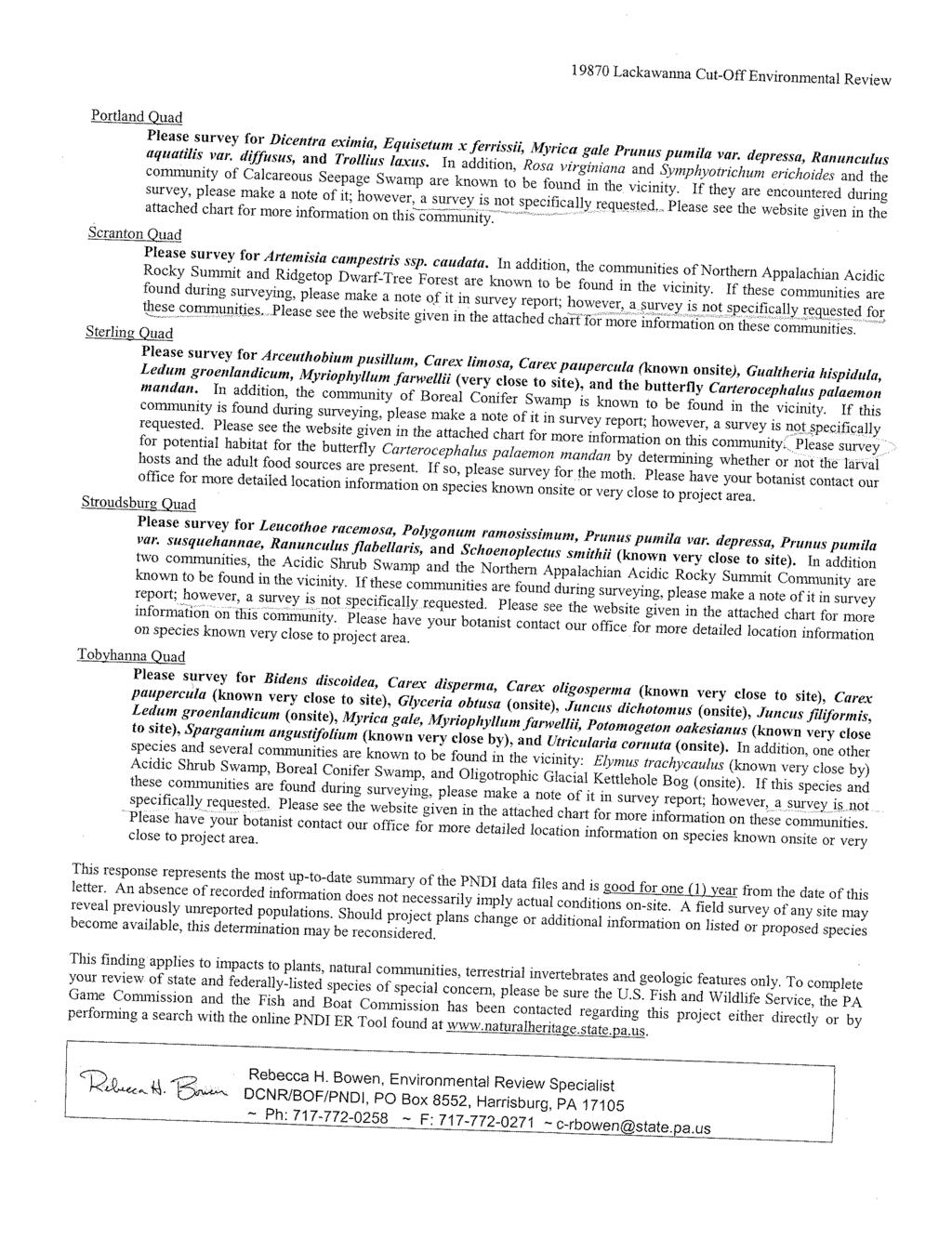
October 2, Mr. John Staples U.S. Fish and Wildlife Service 927 North Main Street Pleasantville, New Jersey 08232
|
|
|
- Evan Weaver
- 5 years ago
- Views:
Transcription
1 299 Madison Avenue Morristown, New Jersey U.S.A Fax October 2, 2008 Mr. John Staples U.S. Fish and Wildlife Service 927 North Main Street Pleasantville, New Jersey Re: Threatened and Endangered Species Data Request for the New Jersey Pennsylvania Lackawanna Cut-Off Passenger Rail Service Restoration Environmental Assessment, Morris, Sussex and Warren Counties, NJ. Dear Mr. Staples: NJ TRANSIT is currently investigating the restoration of rail service on the Lackawanna Cut-Off formerly operated as part of the Erie Lackawanna Railroad, as a transportation solution geared toward improving mobility within Morris, Sussex and Warren counties in New Jersey and Monroe, Lackawanna and Northampton Counties in northwestern Pennsylvania. The service under consideration would operate between Scranton, Pa. and Hoboken, NJ. The portion of the Lackawanna Cut-Off located in New Jersey is currently inactive and is being assessed on the potential environmental impacts of reactivating commuter rail service between the Delaware River Viaduct and Port Morris, NJ. On behalf of NJ TRANSIT we are requesting an updated database search regarding threatened or endangered species along the project corridor and at proposed candidate station/yard locations. The alignment is highlighted in orange on the attached 11x17 copies of the Portland NJ. - PA., Blairstown, NJ., Tranquility, NJ. and the Stanhope, NJ. USGS 7.5 minute series topographic quadrangles. Proposed candidate station locations are called out and highlighted in tan along the proposed alignment. Each station would generally consist of a platform, pedestrian walkways where necessary, kiss-and-ride areas, and parking areas. Enclosed please find a copy of the previous response letter from May 30, We are requesting an updated response to the enclosed information.
2 Should you have any questions or require additional information to process this request, please contact Stephen Ricucci, Senior Environmental Planner, at (973) , extension 1364 Sincerely, Jayne Yost Senior Planner Enclosures: Previous response letter from the U.S. Fish and Wildlife Service New Jersey Field Office, dated May 30, USGS 7.5 minute topographic map quadrangles with the proposed alignment and potential station locations under study; Portland, NJ-PA. Blairstown, NJ. Tranquility, NJ. Stanhope, NJ. Page 2 of 2
3 299 Madison Avenue Morristown, New Jersey U.S.A Fax October 2, 2008 Robert Anderson U.S. Fish and Wildlife Service Pennsylvania Field Office 315 South Allen Street, Suit 322 State College, PA Re: Threatened and Endangered Species Data Request for the New Jersey Pennsylvania Lackawanna Cut-Off Passenger Rail Service Restoration Environmental Assessment. Monroe, Lackawanna, and Northampton Counties, PA. Dear Mr. Anderson: NJ TRANSIT is currently investigating the restoration of rail service on the Lackawanna Cut-Off formerly operated as part of the Erie Lackawanna Railroad, as a transportation solution geared toward improving mobility within Monroe, Lackawanna and Northampton Counties in northwestern Pennsylvania and Warren, Sussex and Morris Counties in New Jersey. The service under consideration would operate between Scranton, Pa. and Hoboken, NJ. The portion of the corridor located in Pennsylvania remains active to freight rail service from Scranton to Slateford Junction in Northhampton County. An Environmental Assessment (EA) is in the process of being finalized pursuant to the National Environmental Policy Act (NEPA) of 1969, for the entire 88 mile corridor. On behalf of NJ TRANSIT we are requesting updated database information regarding threatened or endangered species along the project corridor and at proposed station/yard sites. The corridor is highlighted in transparent orange on the attached 11x17 copies of the Scranton, PA., Olyphant, PA., Moscow, PA., Sterling, PA., Tobyhanna, PA., Buck Hill Falls, PA., Pocono Pines, PA., Mount Pocono, PA., East Stroudsburg, PA., Stroudsburg, PA. and the Portland, NJ. - PA. USGS 7.5 minute series topographic quadrangles. Proposed candidate station/yard locations are called out and highlighted in tan along the proposed alignment. Each station would generally consist of a platform, pedestrian walkways where necessary, kissand-ride areas, and parking areas. Enclosed please find a copy of the previous response letter from August 21, We are requesting an updated response to the enclosed information.
4 Should you have any questions or require additional information to process this request, please contact Stephen Ricucci, Senior Environmental Planner, at (973) , extension Sincerely, Jayne Yost Senior Planner Enclosures; Previous response letter from the U.S. Fish and Wildlife Service Pennsylvania Field Office, August 21, USGS 7.5 min series topographic quadrangles under study; Scranton, PA. Olyphant, PA. Moscow, PA. Sterling, PA. Tobyhanna, PA. Buck Hill Falls, PA. Pocono Pines, PA. Mount Pocono, PA. East Stroudsburg, PA. Stroudsburg, PA. Portland, NJ-PA. Page 2 of 2
5 299 Madison Avenue Morristown, New Jersey U.S.A Fax October 2, 2008 Kevin Mixon Environmental Review Specialist Bureau of Land Management Pennsylvania Game Commission 2001 Elmerton Avenue Harrisburg, PA Re: Threatened and Endangered Species Data Request for the New Jersey Pennsylvania Lackawanna Cut-Off Passenger Rail Service Restoration Environmental Assessment. Monroe, Lackawanna, and Northampton Counties, PA. Dear Mr. Mixon: NJ TRANSIT is currently investigating the restoration of rail service on the Lackawanna Cut-Off formerly operated as part of the Erie Lackawanna Railroad, as a transportation solution geared toward improving mobility within Monroe, Lackawanna and Northampton Counties in northwestern Pennsylvania and Warren, Sussex and Morris Counties in New Jersey. The service under consideration would operate between Scranton, Pa. and Hoboken, NJ. The portion of the corridor located in Pennsylvania remains active to freight rail service from Scranton to Slateford Junction in Northhampton County. On behalf of NJ TRANSIT we are requesting updated database information regarding threatened or endangered species along the project corridor and at proposed station sites. The corridor is highlighted in transparent orange on the attached 11x17 copies of the Scranton, PA., Olyphant, PA., Moscow, PA., Sterling, PA., Tobyhanna, PA., Buck Hill Falls, PA., Pocono Pines, PA., Mount Pocono, PA., East Stroudsburg, PA., Stroudsburg, PA. and the Portland, NJ. - PA. USGS 7.5 minute series topographic quadrangles. Proposed candidate station/yard locations are called out and highlighted in tan along the proposed alignment. Each station would generally consist of a platform, pedestrian walkways where necessary, kissand-ride areas, and parking areas. Enclosed please find a copy of the previous response letter from June 12, We are requesting an updated response to the enclosed information.
6 Should you have any questions or require additional information to process this request, please contact Stephen Ricucci, Senior Environmental Planner, at (973) , extension Sincerely, Jayne Yost Senior Planner Enclosures: Previous Pennsylvania Game Commission response letter from the Pennsylvania Department of Conservation and Natural Resources, June 12, USGS 7.5 min series topographic quadrangles under study; Scranton, PA. Olyphant, PA. Moscow, PA. Sterling, PA. Tobyhanna, PA. Buck Hill Falls, PA. Pocono Pines, PA. Mount Pocono, PA. East Stroudsburg, PA. Stroudsburg, PA. Portland, NJ-PA. Page 2 of 2
7 299 Madison Avenue Morristown, New Jersey U.S.A Fax October 2, 2008 Ellen M. Shultzabarger Pennsylvania Department of Conservation and Natural Resources Bureau of Forestry P.O. Box 8552 Harrisburg, PA Re: Threatened and Endangered Species Data Request for the New Jersey Pennsylvania Lackawanna Cut-Off Passenger Rail Service Restoration Environmental Assessment. Monroe, Lackawanna, and Northampton Counties, PA. PER NO: Dear Ms. Shultzabarger: NJ TRANSIT is currently investigating the restoration of rail service on the Lackawanna Cut-Off formerly operated as part of the Erie Lackawanna Railroad, as a transportation solution geared toward improving mobility within Monroe, Lackawanna and Northampton Counties in northwestern Pennsylvania and Warren, Sussex and Morris Counties in New Jersey. The service under consideration would operate between Scranton, Pa. and Hoboken, NJ. The portion of the corridor located in Pennsylvania remains active to freight rail service from Scranton to Slateford Junction in Northhampton County. On behalf of NJ TRANSIT we are requesting updated database information regarding threatened or endangered species along the project corridor and at proposed station sites. The corridor is highlighted in transparent orange on the attached 11x17 copies of the Scranton, PA., Olyphant, PA., Moscow, PA., Sterling, PA., Tobyhanna, PA., Buck Hill Falls, PA., Pocono Pines, PA., Mount Pocono, PA., East Stroudsburg, PA., Stroudsburg, PA. and the Portland, NJ. - PA. USGS 7.5 minute series topographic quadrangles. Proposed candidate station/yard locations are called out and highlighted in tan along the proposed alignment. Each station would generally consist of a platform, pedestrian walkways where necessary, kissand-ride areas, and parking areas. Enclosed please find a copy of the previous response letter from May 18, 2007 and August 13, We are requesting an updated response to the enclosed information.
8 Should you have any questions or require additional information to process this request, please contact Stephen Ricucci, Senior Environmental Planner, at (973) , extension Sincerely, Jayne Yost Senior Planner Enclosures: Previous PNDI response letter from the Pennsylvania Department of Conservation and Natural Resources, May 18, 2007 and August 13, USGS 7.5 min series topographic quadrangles under study; Scranton, PA. Olyphant, PA. Moscow, PA. Sterling, PA. Tobyhanna, PA. Buck Hill Falls, PA. Pocono Pines, PA. Mount Pocono, PA. East Stroudsburg, PA. Stroudsburg, PA. Portland, NJ-PA. Page 2 of 2
9 299 Madison Avenue Morristown, New Jersey U.S.A Fax October 2, 2008 Christopher Urban, Chief Natural Diversity Section Division of Environmental Services Pennsylvania Fish and Boat Commission 450 Robinson Lane Bellefonte, PA Re: Threatened and Endangered Species Data Request for the New Jersey Pennsylvania Lackawanna Cut-Off Passenger Rail Service Restoration Environmental Assessment. Monroe, Lackawanna, and Northampton Counties, PA. Dear Mr. Urban: NJ TRANSIT is currently investigating the restoration of rail service on the Lackawanna Cut-Off formerly operated as part of the Erie Lackawanna Railroad, as a transportation solution geared toward improving mobility within Monroe, Lackawanna and Northampton Counties in northwestern Pennsylvania and Warren, Sussex and Morris Counties in New Jersey. The service under consideration would operate between Scranton, Pa. and Hoboken, NJ. The portion of the corridor located in Pennsylvania remains active to freight rail service from Scranton to Slateford Junction in Northhampton County. On behalf of NJ TRANSIT we are requesting updated database information regarding threatened or endangered species along the project corridor and at proposed station sites. The corridor is highlighted in transparent orange on the attached 11x17 copies of the Scranton, PA., Olyphant, PA., Moscow, PA., Sterling, PA., Tobyhanna, PA., Buck Hill Falls, PA., Pocono Pines, PA., Mount Pocono, PA., East Stroudsburg, PA., Stroudsburg, PA. and the Portland, NJ. - PA. USGS 7.5 minute series topographic quadrangles. Proposed candidate station/yard locations are called out and highlighted in tan along the proposed alignment. Each station would generally consist of a platform, pedestrian walkways where necessary, kissand-ride areas, and parking areas. Enclosed please find a copy of the previous response letter from June 19, We are requesting an updated response to the enclosed information.
10 Should you have any questions or require additional information to process this request, please contact Stephen Ricucci, Senior Environmental Planner, at (973) , extension Sincerely, Jayne Yost Senior Planner Enclosures: Previous response letter from the Pennsylvania Fish and Boat Commission, June 19, USGS 7.5 min series topographic quadrangles under study; Scranton, PA. Olyphant, PA. Moscow, PA. Sterling, PA. Tobyhanna, PA. Buck Hill Falls, PA. Pocono Pines, PA. Mount Pocono, PA. East Stroudsburg, PA. Stroudsburg, PA. Portland, NJ-PA. Page 2 of 2
11 299 Madison Avenue Morristown, New Jersey U.S.A Fax October 2, 2008 Mr. Herbert Lord Office of Natural Lands Management Natural Heritage Program P.O. Box South Clinton Avenue Trenton, New Jersey Re: Threatened and Endangered Species Data Request for the New Jersey Pennsylvania Lackawanna Cut-Off Passenger Rail Service Restoration Environmental Assessment Morris, Sussex and Warren Counties, New Jersey. Dear Mr. Lord: NJ TRANSIT is currently investigating the restoration of rail service on the Lackawanna Cut-Off formerly operated as part of the Erie Lackawanna Railroad, as a transportation solution geared toward improving mobility within Morris, Sussex and Warren counties in New Jersey and Monroe, Lackawanna and Northampton Counties in northwestern Pennsylvania. The service under consideration would operate between Scranton, Pa. and Hoboken, NJ. The portion of the Lackawanna Cut-Off located in New Jersey is currently inactive and is under study to assess the potential impacts of reactivating commuter rail service between the Delaware River Viaduct and Port Morris, NJ. On behalf of NJ TRANSIT we are requesting an updated database search regarding threatened or endangered species along the project corridor and at proposed candidate station locations. The alignment is highlighted in orange on the attached 11x17 copies of the Portland NJ. - PA., Blairstown, NJ., Tranquility, NJ. and the Stanhope, NJ. USGS 7.5 minute series topographic quadrangles. Proposed candidate station locations are called out and highlighted in tan along the proposed alignment. Each station would generally consist of a platform, pedestrian walkways where necessary, kiss-and-ride areas, and parking areas.
12 Enclosed please find a copy of the previous response letter. We are requesting your concurrence with this previous response or an updated response to the enclosed information. Should you have any questions or require additional information to process this request, please contact Stephen Ricucci, Senior Environmental Planner, at (973) , extension Sincerely, Jayne Yost Senior Planner Enclosures: Previous response letter from the Office of Natural Lands Management, Natural Heritage Program, May 22, USGS 7.5 min topographic map quadrangles with the proposed alignment and potential station locations under study; Portland, NJ-PA. Blairstown, NJ. Tranquility, NJ. Stanhope, NJ. Page 2 of 2
13
14
15
16
17
18
19
20
21
22
23
24
25
26
27
28
29 299 Madison Avenue Morristown, New Jersey U.S.A Fax December 24, 2008 Elaine Moyer U.S. Army Corps of Engineers Pocono Field Office RR1, Box 1487 Gouldsboro, PA Re: Wetland Delineation Reports and Threatened and Endangered Species Assessment for the Non- MOS Segment of the New Jersey Pennsylvania Lackawanna Cut-Off Passenger Rail Service Restoration Project. Dear Ms. Moyer: As requested by Sam Reynolds, enclosed please find a copy of the Lackawanna Cut-off Passenger Rail Service Restoration Project Supplemental Threatened and Endangered Species Assessment for the Non- MOS segment of the project, which runs from Andover, NJ to Scranton, PA and copies of the Wetland Delineation Reports prepared for the New Jersey and Pennsylvania portions of the Non-MOS segment for your review. Previously Sam had provided comments on the MOS portion of the project, through a letter sent to FTA on September 5, We are assuming he will provide comments on the Non-MOS segment, with your input. Should you have any questions or require additional information to process this request, please contact me at (973) , extension 1202 or Kimberly.Glinkin@Jacobs.com. Sincerely, Kimberly Glinkin, AICP/PP Project Manager Jacobs Engineering Group cc: Vincent Truncellito, NJ TRANSIT Donald Burns, FTA
30
31
32
33
34

35
36
37 Glinkin, Kimberly From: Glinkin, Kimberly Sent: Thursday, December 11, :04 PM To: Subject: NJ TRANSIT Lackawanna Cut-Off Rail Project Attachments: Pocono_Mtn._Analysis.pdf Pamela, The only project element that would have an impact to forests is the Pocono Mountain Station. This station would disturb approximately acres of forest. This same station is also the only project element in the vicinity of potential Bog turtle habitat, at a distance of more than 380 feet, as shown on the attached map. The other potential Bog turtle habitat locations identified in the Threatened and Endangered Species Assessment (PA-A, PA-B, PA-C, PA-D, and PA-E) are not located near any proposed sidings or stations or any other project element. Please let me know if any additional information or mapping would be useful for your review of the project. Thank you very much, Kim Glinkin Jacobs Engineering Group 299 Madison Avenue Morristown, NJ : x1202 : : kimberly.glinkin@jacobs.com Pocono_Mtn._Analy sis.pdf (2 MB...


38 Pocono Mountain Candidate Station Coolbaugh Township o Lynchwo d Lake Haw key R Feet ft t. 387 f 0 P Hawkey ond 1 To PA 61 - un Acres
39
40
41
42
43
44
45
46
47
Appendix I-1: Archaeological Records Search
 Appendix I-1: Archaeological Records Search South Central Coastal Information Center California State University, Fullerton Department of Anthropology MH-426 800 North State College Boulevard Fullerton,
August 25, Dear Madam or Sir:
 August 25, 2015 Department of Conservation and Natural Resources Bureau of Forestry, Ecological Services Section 400 Market Street, PO Box 8552 Harrisburg, 17105 Re: Large Project PNDI Shell Pipeline Company,
Director, Operations Services, Met-Ed
 Director, Operations Services, Met-Ed Pennsylvania House Republican Policy Committee Hearing on Storm Response Tobyhanna Township Municipal Building Pocono Pines, Pa. August 9, 2018 Planning and Forecast
APPLICATION TO AMEND THE FUTURE LAND USE MAP (FLUM) SMALL SCALE
 SMALL SCALE") DEPARTMENT OF DEVELOPMENT & PLANNING 825 Ohio Avenue - Lynn Haven, FL 32444 (850) 265-2961 - (850) 265-3478 APPLICATION TO AMEND THE FUTURE LAND USE MAP (FLUM) SMALL SCALE Deadline to submit is 30 days
DEPARTMENT OF DEVELOPMENT & PLANNING 825 Ohio Avenue - Lynn Haven, FL 32444 (850) 265-2961 - (850) 265-3478 APPLICATION TO AMEND THE FUTURE LAND USE MAP (FLUM) SMALL SCALE Deadline to submit is 30 days
Elk River Resources, LLC Andrews County, TX Sec 24, Blk 12, University Land Survey Wapiti H Wellbore #1 Survey: MWD Surveys (QES) QES Survey Re
 QES Survey Re") Elk River Resources, LLC Andrews County, TX Sec 24, Blk 12, University Land Survey Wapiti 12-24 1H Wellbore #1 Survey: MWD Surveys (QES) QES Survey Report 08 February, 2017 QES Directional Drilling, LLC
Elk River Resources, LLC Andrews County, TX Sec 24, Blk 12, University Land Survey Wapiti 12-24 1H Wellbore #1 Survey: MWD Surveys (QES) QES Survey Report 08 February, 2017 QES Directional Drilling, LLC
Hydrologic Conditions in the Delaware River Basin
 2017 Hydrologic Conditions in the Delaware River Basin Prepared by Operations Staff June 2018 Hydrologic Highlights Hydrologic Conditions in the Delaware River Basin Annual Report 2017 At the start of
Sacred Lands File & Native American Contacts List Request
 Sacred Lands File & Native American Contacts List Request NATIVE AMERICAN HERITAGE COMMISSION 915 Capitol Mall, RM 364 Sacramento, CA 95814 (916) 653-4082 (916) 657-5390 Fax nahc@pacbell.net Information
404 Nationwide Permit: File No. SPL PKK FWS-LA-14B F0556 Streambed Alteration Agreement Notification No.
 HELIX Environmental Planning, Inc. 7578 El Cajon Boulevard La Mesa, CA 91942 619.462.1515 tel 619.462.0552 fax www.helixepi.com July 17, 2017 Ms. Colleen Draguesku Carlsbad Fish and Wildlife Office 2177
ENVIRONMENTAL DIVISION Arkansas State Highway and Transportation Department. Streamlining Environmental Assessment through GIS
 ENVIRONMENTAL DIVISION Arkansas State Highway and Transportation Department Streamlining Environmental Assessment through GIS 2 September, 2003 ARKANSAS STATE HIGHWAY AND TRANSPORTATION DEPARTMENT ENVIRONMENTAL
MVP WMS, George Schorr
 APPROVED JURISDICTIONAL DETERMINATION FORM U.S. Army Corps of Engineers This form should be completed by following the instructions provided in Section IV of the JD Form Instructional Guidebook. SECTION
Electronic Submission Format Guide Anthracite Preparation Plant Permit Application
 Electronic Submission Format Guide Anthracite Preparation Plant Permit Application Module 1: Application Section A through Section J, the Application Checklist, and all narrative responses Act 67 / 68
Electronic Submission Format Guide Bituminous Coal Surface Mine Permit Application (5600-PM-BMP0311)
") Electronic Submission Format Guide Bituminous Coal Surface Mine Permit Application (5600-PM-BMP0311) Module 1: Application Section A through Section J, the Application Checklist, and all narrative responses.
Electronic Submission Format Guide Bituminous Coal Surface Mine Permit Application (5600-PM-BMP0311) Module 1: Application Section A through Section J, the Application Checklist, and all narrative responses.
December 16, Mr. Lee Hughes Southwest Florida Water Management District Tampa Service Office 7601 Highway 301 North Tampa, FL 33637
 December 16, 2015 Mr. Lee Hughes Southwest Florida Water Management District Tampa Service Office 7601 Highway 301 North Tampa, FL 33637 RE: Response to SWFWMD Supplemental Information Request Dear Mr.
NORTHUMBERLAND COUNTY, PA
 QUAKER RUN Stream and Wetland Restoration As-Built Completion Report and First Year Monitoring Data Coal Township NORTHUMBERLAND COUNTY, PA Upstream Before Upstream After Prepared for: COAL TOWNSHIP 805
FS Original Hole Ft April 26, 2016
 Oilfield Services, Central U.S. Land PathFinder A Schlumberger Company Drilling Group Geo Market Area: South East Texas Basin 3600 BriarPark Houston, Texas 77042 Phone : (713) 789-9600 (Main) Fax : (713)
2017 ALL COUNTY CONFERENCE JUNIOR FOOTBALL SCHEDULE
 2017 ALL COUNTY CONFERENCE JUNIOR FOOTBALL SCHEDULE First Day OF Practice Monday July 24 2017 Pre Season Sunday August 6 2017 Sunday August 13 2017 Week 1-Cross over Saturday August 19 2017 1:45 PM Start
Minimum Standards for Wetland Delineations
 Minimum Standards for Wetland Delineations Jason Gipson Chief, Utah/Nevada Regulatory Branch Sacramento District Regulatory Program Workshop 16 Mar 2016 US Army Corps of Engineers Delineation Report Minimum
October 16, Dear Mr. Hawkins:
 IBI GROUP 101 410 Albert Street Waterloo ON N2L 3V3 Canada tel 519 585 2255 fax 519 585 2269 October 16, 2017 Mr. Trevor Hawkins Manager of Applications and Implementation Integrated Planning and Public
The following maps must be provided as a part of the ADA. The appropriate scale for each map should be determined at the pre application conference.
 Main Street @ Coconut Creek DRI QUESTION 9 MAPS The following maps must be provided as a part of the ADA. The appropriate scale for each map should be determined at the pre application conference. Map
Great California Delta Trail Blueprint for Contra Costa and Solano Counties GIS AND MAPPING MEMORANDUM JULY 2010
 Great California Delta Trail Blueprint for Contra Costa and Solano Counties GIS AND MAPPING MEMORANDUM JULY 2010 {DRAFT} July 2010 Introduction Geographic Information Systems (GIS) are computer-based
APPROVED JURISDICTIONAL DETERMINATION FORM U.S. Army Corps of Engineers
 APPROVED JURISDICTIONAL DETERMINATION FORM U.S. Army Corps of Engineers This form should be completed by following the instructions provided in Section IV of the JD Form Instructional Guidebook. SECTION
Hillsborough County MPO Transit Study. Technical Team August 23, 2007
 Hillsborough County MPO Transit Study Technical Team August 23, 2007 Meeting Agenda Technology Choices Needs and Opportunities Transit Concepts Comparative Land Use Analysis Measures of Effectiveness System
Information Paper. Kansas City District. Missouri River Fish and Wildlife Mitigation Project Jim and Olivia Hare Wildlife Area, MO
 City District Information Paper River Fish and Wildlife Mitigation Project Jim and Olivia Hare Wildlife Area, MO Riverine habitat created in 2004/2005 by modifying existing river structures along the banks,
APPROVED JURISDICTIONAL DETERMINATION FORM U.S. Army Corps of Engineers
 APPROVED JURISDICTIONAL DETERMINATION FORM U.S. Army Corps of Engineers This form should be completed by following the instructions provided in Section IV of the JD Form Instructional Guidebook. SECTION
Town Lines 2007 Municipal Officials & Statistics
 Town Lines 2007 Municipal Officials & Statistics 63 64 TOP PHOTO Nay Aug Gorge, Scranton BOTTOM PHOTO Moffat Estate, Covington Township Municipal Center PHOTOS ON PAGE 63 From top, left to right Ransom
NOAA s National Weather Service Philadelphia/Mt. Holly NJ. Summary. Changes
 Summary A crippling and potentially historic east coast snow storm will lead to blizzard conditions and major coastal flooding for portions of the area this weekend. Changes Blizzard Warning has been expanded
SUMMARY OF SOIL CONDITIONS CITYWIDE SIDEWALK IMPROVEMENT PROJECT JIMMY DURANTE BOULEVARD, VIA DE LA VALLE, AND CAMINO DEL MAR DEL MAR, CALIFORNIA
 SUMMARY OF SOIL CONDITIONS CITYWIDE SIDEWALK IMPROVEMENT PROJECT JIMMY DURANTE BOULEVARD, VIA DE LA VALLE, AND CAMINO DEL MAR DEL MAR, CALIFORNIA PREPARED FOR NASLAND ENGINEERING SAN DIEGO, CALIFORNIA
Planning Commission Report
 QX f BEVERLY HILLS City of Beverly Hills Planning Division 455 N. Rexford Drive Beverly Hills, CA 90210 TEL. (310) 285-1141 FAX. (310) 858-5966 Meeting Date: Subject: Project Applicant: Recommendation:
APPLICATION FOR CHANGE OF WATER RIGHT
 District Court, Water Division, Colorado Court Address: CONCERNING THE APPLICATION FOR WATER RIGHTS OF Applicant: In the River or its Tributaries In COUNTY COURT USE ONLY Attorney or Party Without Attorney
Electronic Submission Format Guide Large Noncoal (Industrial Minerals) Mine Permit Application (5600-PM-BMP0315)
 Mine Permit Application (5600-PM-BMP0315)") Electronic Submission Format Guide Large Noncoal (Industrial Minerals) Mine Permit Application (5600-PM-BMP0315) Module 1: Application Section A through Section I, the Application Checklist, and all narrative
Electronic Submission Format Guide Large Noncoal (Industrial Minerals) Mine Permit Application (5600-PM-BMP0315) Module 1: Application Section A through Section I, the Application Checklist, and all narrative
Name of Applicant Mailing Address address Telephone Number
 District Court, Water Division, Colorado Court Address: CONCERNING THE APPLICATION FOR WATER RIGHTS OF Applicant: In the River or its Tributaries In COUNTY Attorney or Party Without Attorney (Name and
This material is part of the collection of the Philadelphia Water Department and was downloaded from the website Please contact the
 This material is part of the collection of the Philadelphia Water Department and was downloaded from the website www.phillyh2o.org Please contact the PhillyH2O webmaster for more information about this
Appendix A 2011 Air Monitoring Sites
 Appendix A 2011 Air Monitoring Sites New Jersey Department of Environmental Protection Appendix A 1 www.njaqinow.net FIGURE 1 NORTHERN NEW JERSEY AIR MONITORING SITES Appendix A 2 www.njaqinow.net County
Information for File MVP RMM
 Information for File MVP-2013-03320-RMM Applicant: City of St. Cloud Corps Contact: Ryan Malterud Address: 180 Fifth Street East, Suite 700, St. Paul, MN 55101 E-Mail: Ryan.M.Malterud@usace.army.mil Phone:
Hydrologic Conditions in the Delaware River Basin
 Hydrologic Conditions in the Delaware River Basin April : Flooding in Lambertville, New Jersey Aerial photo used with permission of www.elevated-images.com Annual Report Prepared by Operations Staff June
Version TNW Only 1 of 3
 APPROVED JURISDICTIONAL DETERMINATION FORM U.S. Army Corps of Engineers SECTION I: BACKGROUND INFORMATION A. REPORT COMPLETION DATE FOR APPROVED JURISDICTIONAL DETERMINATION (JD): 3 Mar 2009. B. DISTRICT
APPROVED JURISDICTIONAL DETERMINATION FORM U.S. Army Corps of Engineers
 APPROVED JURISDICTIONAL DETERMINATION FORM U.S. Army Corps of Engineers This form should be completed by following the instructions provided in Section IV of the JD Form Instructional Guidebook. SECTION
LARAMIE COUNTY PLANNING & DEVELOPMENT DEPARTMENT
 LARAMIE COUNTY PLANNING & DEVELOPMENT DEPARTMENT Planning Building MEMORANDUM TO: FROM: Laramie County Planning Commission Nancy M. Trimble, Associate Planner DATE: October 26, 2017 TITLE: Review and action
4.3 CULTURAL RESOURCES
 4.3 CULTURAL RESOURCES This section of the EIR analyzes the proposed project s potential impacts on archaeological and paleontological resources. This analysis summarizes the findings of the Archaeological
APPLICATION FOR CONDITIONAL ABSOLUTE WATER STORAGE RIGHT
 District Court, Water Division, Colorado Court Address: CONCERNING THE APPLICATION FOR WATER RIGHTS OF Applicant: In the River or its Tributaries In COUNTY Attorney or Party Without Attorney (Name and
APPROVED JURISDICTIONAL DETERMINATION FORM U.S. Army Corps of Engineers
 APPROVED JURISDICTIONAL DETERMINATION FORM U.S. Army Corps of Engineers This form should be completed by following the instructions provided in Section IV of the JD Form Instructional Guidebook. SECTION
APPLICATION FOR SIMPLE CHANGE IN SURFACE POINT OF DIVERSION PURSUANT TO (3.5), C.R.S.
, C.R.S.") District Court, Water Division, Colorado Court Address: CONCERNING THE APPLICATION FOR WATER RIGHTS OF Applicant: In the River or its Tributaries In COUNTY COURT USE ONLY Attorney or Party Without Attorney
District Court, Water Division, Colorado Court Address: CONCERNING THE APPLICATION FOR WATER RIGHTS OF Applicant: In the River or its Tributaries In COUNTY COURT USE ONLY Attorney or Party Without Attorney
Focused Traffic Analysis for the One Lincoln Park Project
 September 15, 2015 Mr. Bill Johnson Coldwell Banker 511 Sir Francis Drake Boulevard Greenbrae, CA 94904 Focused Traffic Analysis for the One Lincoln Park Project Dear Mr. Johnson; As requested, W-Trans
Roy Pyle March 24, 2017 Chief Facilities Planner Contra Costa Community College District 500 North Court Street Martinez, CA 94533
 State of California Natural Resources Agency Edmund G. Brown Jr., Governor Department of Conservation John G. Parrish, Ph.D., State Geologist California Geological Survey 801 K Street MS 12-31 Sacramento,
PLANNING COMMISSION AGENDA
 COUNTY OF IMPERIAL COMMISSIONERS: Chairman: Rudy Schaffner Dennis Bergh Norm Niver Vice Chairman: Carson Kalin Sergio Cabanas Russell Roben Max Castillo Carlton A. Hargrave Ernesto Medina JIM MINNICK,
SlimPulse FS Original Hole Ft August 12, 2017
 Oilfield Services, Central U.S. Land Schlumberger Drilling and Measurements Drilling Group Geo Market Area: South West Texas Basin 7220 W I-H 20 Midland, Texas 79706 Phone : (432) 742-5400 (Main) Fax :(432)
THE HISTORY OF WEATHER OBSERVING IN CHEYENNE, WYOMING,
 THE HISTORY OF WEATHER OBSERVING IN CHEYENNE, WYOMING, 1870-2004 Downtown Cheyenne, Wyoming, circa 1890 From Wyoming State Archives, Department of State Parks and Cultural Resources Current as of January
Kootenai River Habitat Restoration Program Update
 Kootenai River Habitat Restoration Program Update Kootenai Tribe of Idaho Kootenai Valley Resource Initiative November 19, 2012 Bonners Ferry, Idaho Changes to Kootenai Basin Beaver trapping Floodplain
APPROVED JURISDICTIONAL DETERMINATION FORM U.S. Army Corps of Engineers
 APPROVED JURISDICTIONAL DETERMINATION FORM U.S. Army Corps of Engineers This form should be completed by following the instructions provided in Section IV of the JD Form Instructional Guidebook. SECTION
CHANGE. Purchasing Agent: Name: John Jones Phone: Fax: Valid from/to: 09/01/ /31/2017. Please Deliver To:
 Page 1 of 16 Contract Change Approval Date: 09/01/2016 All using Agencies of the Commonwealth, Participating Political Subdivision, Authorities, Private Colleges and Universities Your SAP Vendor Number
River Realty Services Commercial
 1 4 6 N O R T H U S 9 W, C O N G E R S, N Y 1 0 9 2 0 TA B L E O F C O N T E N T S E X E C U T I V E S U M M A RY 03 Z O N I N G 09 R EG I S T R AT I O N S 04 S U B J EC T P H OTO S 10 M A P V I E W 05
September 21, 2004 GeoInsight Project
 GeoInsight, Inc. GeoInsight, Inc. GeoInsight, Inc. 75 Gilcreast Road, Suite 210 319 Littleton Road, Suite 105 Corporate Ten Center Londonderry, NH 03053-3566 Westford, MA 01886 1781 Highland Avenue, Suite
Information for File # MMJ; Trunk Highway (TH) 7 / Louisiana Ave. Interchange Project
 7 / Louisiana Ave. Interchange Project") Information for File # 2013-00531-MMJ; Trunk Highway (TH) 7 / Louisiana Ave. Interchange Project Applicant: City of St. Louis Park Corps Contact: Melissa Jenny Address: U.S. Army Corps of Engineers Attn:
Information for File # 2013-00531-MMJ; Trunk Highway (TH) 7 / Louisiana Ave. Interchange Project Applicant: City of St. Louis Park Corps Contact: Melissa Jenny Address: U.S. Army Corps of Engineers Attn:
APPROVED JURISDICTIONAL DETERMINATION FORM U.S. Army Corps of Engineers
 APPROVED JURISDICTIONAL DETERMINATION FORM U.S. Army Corps of Engineers This form should be completed by following the instructions provided in Section IV of the JD Form Instructional Guidebook. SECTION
Additional Testing for Padre Dam Eastern Service Area Secondary Connection- Alternative Site Location, San Diego County, California
 Mark Niemiec Padre Dam Municipal Water District P.O. Box 719003 9300 Fanita Parkway Santee, California 92072 Re: Additional Testing for Padre Dam Eastern Service Area Secondary Connection- Alternative
Chapter 6 Mapping and Online Tools
 Chapter 6 Mapping and Online Tools The stream site you monitor is just part of a much larger system. When analyzing stream health, it is important to take a holistic view by considering the entire watershed.
NEWS RELEASE UNDER SECTION 404 OF THE CLEAN WATER ACT (33 USC 1344) ACTION NUMBER SPA ABQ
 ACTION NUMBER SPA ABQ") PUBLIC NOTICE Public Notice Issue Date: //6/07 Albuquerque District Comments due: /6/08 NEWS RELEASE UNDER SECTION 0 OF THE CLEAN WATER ACT ( USC ) ACTION NUMBER SPA-06-00-ABQ BANK STABILIZATION ALONG
PUBLIC NOTICE Public Notice Issue Date: //6/07 Albuquerque District Comments due: /6/08 NEWS RELEASE UNDER SECTION 0 OF THE CLEAN WATER ACT ( USC ) ACTION NUMBER SPA-06-00-ABQ BANK STABILIZATION ALONG
Grant Opportunity Monitoring Bi-State Sage-grouse Populations in Nevada
 Grant Opportunity Monitoring Bi-State Sage-grouse Populations in Nevada Proposals are due no later than November 13, 2015. Grant proposal and any questions should be directed to: Shawn Espinosa @ sepsinosa@ndow.org.
January 12, Mr. Ryan Granger TMGB Wilson, LLC 2221 Health Drive SW, Suite 2200 Wyoming, Michigan 49519
 January 12, 2018 Mr. Ryan Granger TMGB Wilson, LLC 2221 Health Drive SW, Suite 2200 Wyoming, Michigan 49519 Re: Proposed Reserve at Rivertown Mixed-Use Development Updated Trip Generation and Site Driveway
Advanced Geologic Exploration, Inc.
 Advanced Geologic Exploration, Inc. Scientists of the Earth PO Box 1956, Chester, CA 96020 Voice: (530) 258-4228 Fax (530) 258-4339 www.advancedgeologic.com January 23, 2009 Job No. G-081201 Terri Barber,
Preliminary Geotechnical Evaluation Gooseberry Point Pedestrian Improvements Whatcom County, Washington SITE AND PROJECT DESCRIPTION
 File No. 12-100 Geotechnical & Earthquake Engineering Consultants Mr. Kevin Brown, P.E. Gray & Osborne, Inc. 3710 168 th Street NE, Suite B210 Arlington, Washington 98223 Subject: Draft Report Preliminary
Quarterly Report. 01 July 30 September 2014
 Quarterly Report Faculty of FORESTY School of AGRICULTURAL, FOREST, AND ENVIRONMENTAL SCIENCES College of AGRICULTURE, FORESTRY & LIFE SCIENCES Baruch Institute of Coastal Ecology and Forest Sciences Hwy.
Dolores Public Lands Office Highway 184 Dolores, CO Ph (970) Fax (970)
 Fax (970)") USDA Forest Service San Juan National Forest Mancos/Dolores Ranger District http://www.fs.fed.us/r2/sanjuan Dolores Public Lands Office 29211 Highway 184 Dolores, CO 81323 Ph (970) 882-7296 Fax (970) 882-6841
USDA Forest Service San Juan National Forest Mancos/Dolores Ranger District http://www.fs.fed.us/r2/sanjuan Dolores Public Lands Office 29211 Highway 184 Dolores, CO 81323 Ph (970) 882-7296 Fax (970) 882-6841
APPROVED JURISDICTIONAL DETERMINATION FORM U.S. Army Corps of Engineers
 APPROVED JURISDICTIONAL DETERMINATION FORM U.S. Army Corps of Engineers This form should be completed by following the instructions provided in Section IV of the JD Form Instructional Guidebook. SECTION
What discharge (cfs) is required to entrain the D 84 (84 th percentile of sediment size distribution) in Red Canyon Wash?
 is required to entrain the D 84 (84 th percentile of sediment size distribution) in Red Canyon Wash?") Gregory Indivero 31 October 2011 What discharge (cfs) is required to entrain the D 84 (84 th percentile of sediment size distribution) in Red Canyon Wash? What discharge was required to deposit observed
Gregory Indivero 31 October 2011 What discharge (cfs) is required to entrain the D 84 (84 th percentile of sediment size distribution) in Red Canyon Wash? What discharge was required to deposit observed
David Moore, PacifiCorp Cultural Resources Coordinator Denise DeJoseph, Project Archaeologist
 References DeJoseph, Denise 2011 Lewis River HPMP: Swift Camp FSC Survey Negative Results. Memo report submitted by Historical Research Associates to PacifiCorp, Portland, Oregon. Copies available at PacifiCorp,
Geology, Soils, and Seismicity
 Section 3.8 Geology, Soils, and Seismicity Introduction This section generally evaluates the effects of the alternatives analyzed in this Supplemental DEIS with regard to geology, soils and seismicity.
Ocmulgee River Watershed Project Fact Sheet
 Ocmulgee River Watershed Project Fact Sheet What Where The Georgia Department of Community Affairs (DCA) is sponsoring the first in a series of public meetings for stakeholders in the Ocmulgee River Watershed
Crane County, TX Sec. 37, Block 31, University Lands Survey University Lands A 37 #1H. Wellbore #1. Survey: MWD
 Crane County, TX Sec. 37, Block 31, University Lands Wellbore #1 : MWD 16 May, 2012 Date: 1/12/12 Railroad Commission of Texas Oil and Gas Division 1701 North Congress Avenue Austin, Texas 78711 Attention:
G.1. Motion to approve Project Calendar regarding Planning and Development Department Payments as follows:
 G.1.a council memo DATE: Wednesday, January 31, 2018 TO: FROM: RE: Mayor and City Council Tracey Bellach, Administrative Assistant G.1. Motion to approve Project Calendar regarding Planning and Development
FLORIDA DIVISION OF EMERGENCY MANAGEMENT STATE WATCH OFFICE DAILY INCIDENT REPORT
 FLORIDA DIVISION OF EMERGENCY MANAGEMENT STATE WATCH OFFICE DAILY INCIDENT REPORT Incident Number: 2018-7477 Incident Name: Woodville Highway Closed Occurred: 12/6/2018 05:29 ET Reported to SWO: 12/6/2018
Natural Variability in Annual Maximum Water Level and Outflow of Yellowstone Lake
 Natural Variability in Annual Maximum Water Level and Outflow of Yellowstone Lake Phillip E. Farnes Abstract The water level in Yellowstone Lake varies each year in response to differences in the winter
Regional Sediment Management
 Regional Sediment Management Linda S. Lillycrop Program Manager Coastal Engineer US Army Engineer Research and Development Center Coastal and Hydraulics Laboratory Q AVG Coastal Resilience: The Environmental,
Southwest LRT Habitat Analysis. May 2016 Southwest LRT Project Technical Report
 Southwest LRT Habitat Analysis Southwest LRT Project Technical Report This page intentionally blank. Executive Summary This technical report describes the habitat analysis that was performed to support
UNIT 1C. USING TOPOGRAPHIC MAPS WHERE IN THE WORLD... ARE YOU?
 UNIT 1C. USING TOPOGRAPHIC MAPS WHERE IN THE WORLD... ARE YOU? TIME 60-90 minutes LEVEL All BENCHMARKS Next Generation Science Standards MS-LS1.D Science & Engineering Practices Developing and Using Models
Exploring New Jersey s Climate Variability & Change
 Exploring New Jersey s Climate Variability & Change Presentation at the Great Swamp Watershed Association Dr. David A. Robinson Professor, Department of Geography & New Jersey State Climatologist Rutgers
A. My name is Watsun Randolph and my business address is 45 Horner Street Warrenton
 DIRECT TESTIMONY OF WATSUN RANDOLPH ON BEHALF OF PIEDMONT ENVIRONMENTAL COUNCIL BEFORE THE STATE CORPORATION COMMISSION OF VIRGINIA CASE NOS. PUE-00-000 AND PUE-00-000 0 Q. PLEASE STATE YOUR NAME AND BUSINESS
MOODY FLATS QUARRY PROJECT
 MOODY FLATS QUARRY PROJECT Shasta Salamander Habitat Assessment and Survey Report August 24, 2012 Prepared for: Benchmark Resources, Inc. 4990 Hillsdale Circle, Suite 400 Eldorado Hills, CA 95762 Attn:
Bridging between organizations for effective water resource management;
 Bridging between organizations for effective water resource management; a look at a stakeholder network in water governance issues of a rural subbasin aren Trebitz hd student, Water Resources, law, mgt.,
WHITEHEAD 30 (10) (570) (30) (10) & TRACY MILLER.
 (570) (30) (10) & TRACY MILLER.") BEGINNING at a point in the center of Pennsylvania State Highway Route No. 414, said point located on the boundary between the lands herein described and lands now or formerly of Carman Tartaglia; thence
BEGINNING at a point in the center of Pennsylvania State Highway Route No. 414, said point located on the boundary between the lands herein described and lands now or formerly of Carman Tartaglia; thence
SUMMARY OF RESEARCH; UNNAMED ROAD # $ - USGS Topo Proof Map FLPMA The use of and jurisdiction of UNNAMED ROAD # pre-dates the
 SUMMARY OF RESEARCH; UNNAMED ROAD #927 107 195$ - USGS Topo Proof Map 1976- FLPMA The use of and jurisdiction of UNNAMED ROAD #927107 pre-dates the Bureau of Land Management. Historical records of the
Study Overview. the nassau hub study. The Nassau Hub
 Livable Communities through Sustainable Transportation the nassau hub study AlternativeS analysis / environmental impact statement The Nassau Hub Study Overview Nassau County has initiated the preparation
Photo 1. View of Typha angustifolia strip between Phragmites monocultures in Wetland 12. Duck creek corridor at tree line in background.
 Ironville Site: Blanding s Turtle Habitat Assessment Prepared for Amendola Engineering, Inc. Photo 1. View of Typha angustifolia strip between Phragmites monocultures in Wetland 12. Duck creek corridor
FINAL AESTHETICS RESOURCES STUDY PLAN. Takatz Lake Hydroelectric Project, FERC No Prepared by: City and Borough of Sitka Electric Department
 FINAL AESTHETICS RESOURCES STUDY PLAN Takatz Lake Hydroelectric Project, FERC No. 13234 Prepared by: City and Borough of Sitka Electric Department 105 Jarvis St., Sitka AK, 99835 INTRODUCTION and BACKGROUND
225 Bush Street Suite 1700 San Francisco, CA phone fax
 225 Bush Street Suite 1700 San Francisco, CA 94104 415.896.5900 phone 415.896.0332 fax www.esassoc.com memorandum date July 29, 2009 to from subject Craig Nikitas, San Francisco Planning Department Daniel
PENNSYLVANIA DEPARTMENT OF TRANSPORTATION ENGINEERING DISTRICT 3-0
 PENNSYLVANIA DEPARTMENT OF TRANSPORTATION ENGINEERING DISTRICT 3-0 LYCOMING COUNTY S.R.15, SECTION C41 FINAL HYDROLOGIC AND HYDRAULIC REPORT STEAM VALLEY RUN STREAM RELOCATION DATE: June, 2006 REVISED:
Warner Real Estate Advisors, Inc. Minto West Non -Residential Intensity Analysis
 Warner Real Estate Advisors, Inc. Non -Residential Intensity Analysis 12/16/2013 Warner Real Estate Advisors, Inc. Real Estate Research, Market Studies & GIS December 16, 2013 Ms. Tara W. Duhy, Esq. Lewis,
Louisiana Transportation Engineering Conference. Monday, February 12, 2007
 Louisiana Transportation Engineering Conference Monday, February 12, 2007 Agenda Project Background Goal of EIS Why Use GIS? What is GIS? How used on this Project Other site selection tools I-69 Corridor
HYDROLOGIC AND HYDRAULIC REPORT FOR SR. 0522, SECTION 5BN ALONG BLACKLOG CREEK CROMWELL TOWNSHIP HUNTINGDON COUNTY. Prepared for:
 HYDROLOGIC AND HYDRAULIC REPORT FOR SR. 0522, SECTION 5BN ALONG BLACKLOG CREEK CROMWELL TOWNSHIP Prepared for: KCI Technologies, Inc. Mechanicsburg, PA and Pennsylvania Department of Transportation Engineering
BEFORE THE PUBLIC SERVICE COMMISSION OF MARYLAND
 BEFORE THE PUBLIC SERVICE COMMISSION OF MARYLAND IN THE MATTER OF THE APPLICATION OF * MASON DIXON SOLAR CENTER, LLC FOR A CERTIFICATE OF PUBLIC * Case No.: 9426 CONVENIENCE AND NECESSITY TO CONSTRUCT
SUMMARY OF RESEARCH; EASY CHAIR CRATER ROAD # USGS Topo Proof Map FLPMA The use of and jurisdiction of EASY CHAIR CRATER ROAD
 SUMMARY OF RESEARCH; EASY CHAIR CRATER ROAD #955540 1967 - USGS Topo Proof Map 1976 - FLPMA The use of and jurisdiction of EASY CHAIR CRATER ROAD #955540 pre-dates the Bureau of Land Management. Historical
BEFORE THE HEARING EXAMINER IN AND FOR THE COUNTY OF THURSTON
 BEFORE THE HEARING EXAMINER IN AND FOR THE COUNTY OF THURSTON In the Matter of the Application of FILE NO. SSDP 020135 AAPL 020135 Confederated Tribes of the Chehalis Reservation For a Shoreline Substantial
One Hilltop, Three Major Watersheds!
 One Hilltop, Three Major Watersheds! Adapted from: An original Creek Connections activity. Creek Connections, Box E, Allegheny College, Meadville, Pennsylvania, 16335 Watersheds of PA/ Topo Map Review
Township 34 North, Range 9 West, NMPM (NUL) Section 3: E/2
 Section 3: E/2") BEFORE THE OIL AND GAS CONSERVATION COMMISSION OF THE STATE OF COLORADO IN THE MATTER OF THE APPLICATION OF CHEVRON MIDCONTINENT, L.P., IGNACIO-BLANCO FIELD, LA PLATA COUNTY, COLORADO. CAUSE NO. 112 DOCKET
BEFORE THE OIL AND GAS CONSERVATION COMMISSION OF THE STATE OF COLORADO IN THE MATTER OF THE APPLICATION OF CHEVRON MIDCONTINENT, L.P., IGNACIO-BLANCO FIELD, LA PLATA COUNTY, COLORADO. CAUSE NO. 112 DOCKET
NAME DATE TOPOGRAPHIC MAPS. Activity 1: Topographic Map Investigation I: More Than a Road Map
 NAME DATE PARTNER(S) TOPOGRAPHIC MAPS Now you have seen how topographic maps can be generated to present the elevation of a terrain. Let s look at some topographic maps and learn how to interpret them.
132 Imperial Road North Bay, Ontario P1A 4M5. Subject: Tower Site Proposed for Trout Lake, 1427 Owl s Nest Road, Township of Hoskin
 132 Imperial Road North Bay, Ontario P1A 4M5 August 27, 2013 Mr. Nikolic (Bob) Slobodan TLCASD PO Box 315 Noelville, ON P0M 2N0 (Transmitted by e-mail) Subject: Tower Site Proposed for Trout Lake, 1427
COUNTY OF SONOMA PERMIT AND RESOURCE MANAGEMENT DEPARTMENT 2550 Ventura Avenue, Santa Rosa, CA (707) FAX (707)
 FAX (707)") COUNTY OF SONOMA PERMIT AND RESOURCE MANAGEMENT DEPARTMENT 2550 Ventura Avenue, Santa Rosa, CA 95403 (707) 565-1900 FAX (707) 565-1103 DATE : TO: FROM: SUBJECT: July 21, 2009 at 2:30 p.m. Board of Supervisors
COUNTY OF SONOMA PERMIT AND RESOURCE MANAGEMENT DEPARTMENT 2550 Ventura Avenue, Santa Rosa, CA 95403 (707) 565-1900 FAX (707) 565-1103 DATE : TO: FROM: SUBJECT: July 21, 2009 at 2:30 p.m. Board of Supervisors
In order to give all interested parties an opportunity to express their views
 PUBLIC NOTI C E CHARLESTON DISTRICT CORPS OF ENGINEERS 69A Hagood Avenue Charleston South Carolina 29403-5107 REGULATORY DIVISION December 5 2012 Refer to: PIN # SAC-2012-00851 Pursuant to Sections 401
2016 Hydrologic. Conditions in the Delaware River Basin. Low flows in the Delaware River at the Washington Crossing Bridge October 18, 2016
 2016 Hydrologic Conditions in the Delaware River Basin Low flows in the Delaware River at the Washington Crossing Bridge October 18, 2016 Prepared by Water Resource Operations Staff April 2017 Hydrologic
Incas Manganese Prospect, Bristol Mountains, San Bernardino County, California
 Incas Manganese Prospect, Bristol Mountains, San Bernardino County, California Gregg Wilkerson 2017 Acknowledgement and Disclaimer The information in this paper is taken largely from published sources.