SP-Site Plan SPM-Site Plan Minor LPU-Unplateed SD FP-Final Plat D.O.'s not attached owe fees. Development Orders Approved in 2013
|
|
|
- Carmel Ellis
- 5 years ago
- Views:
Transcription
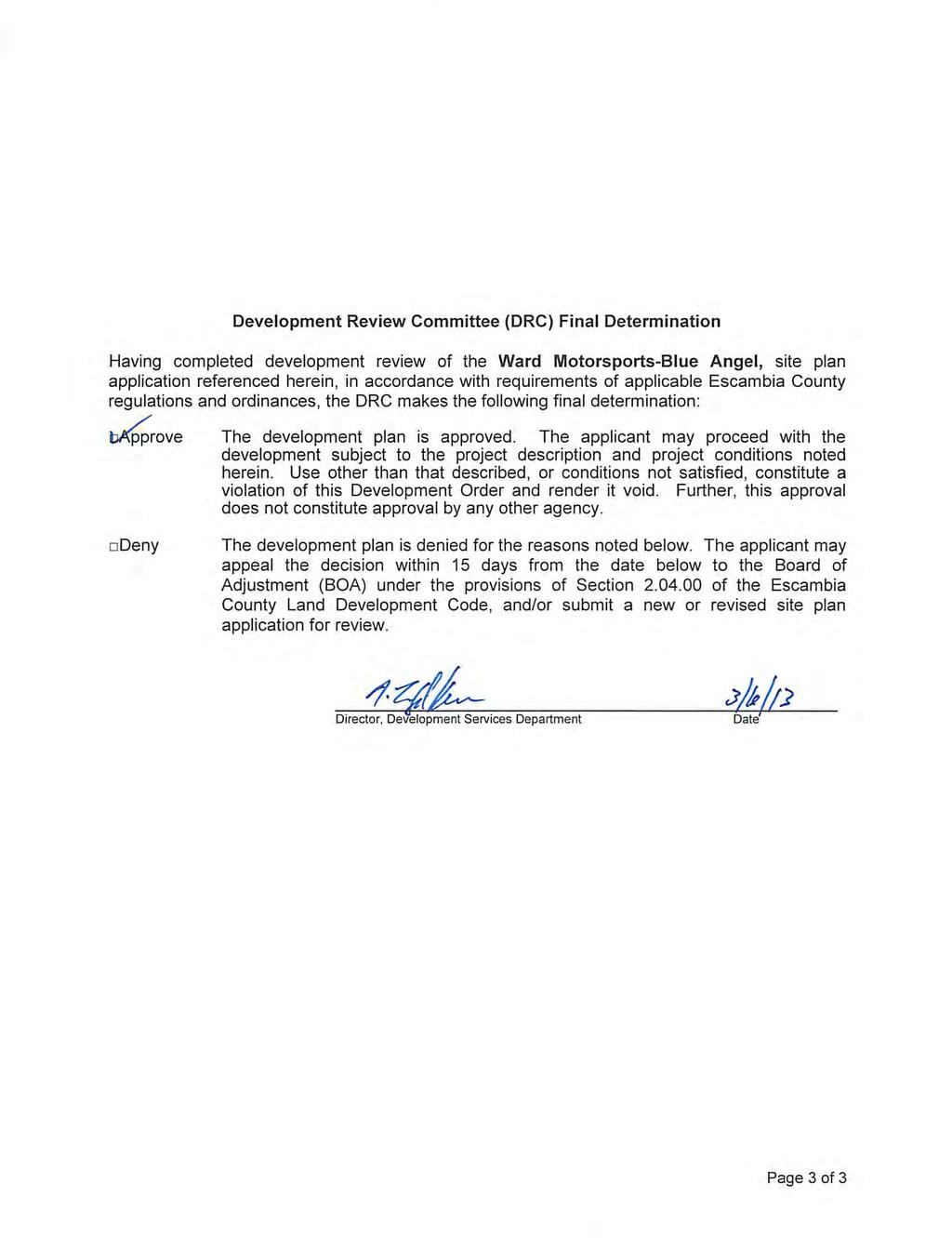
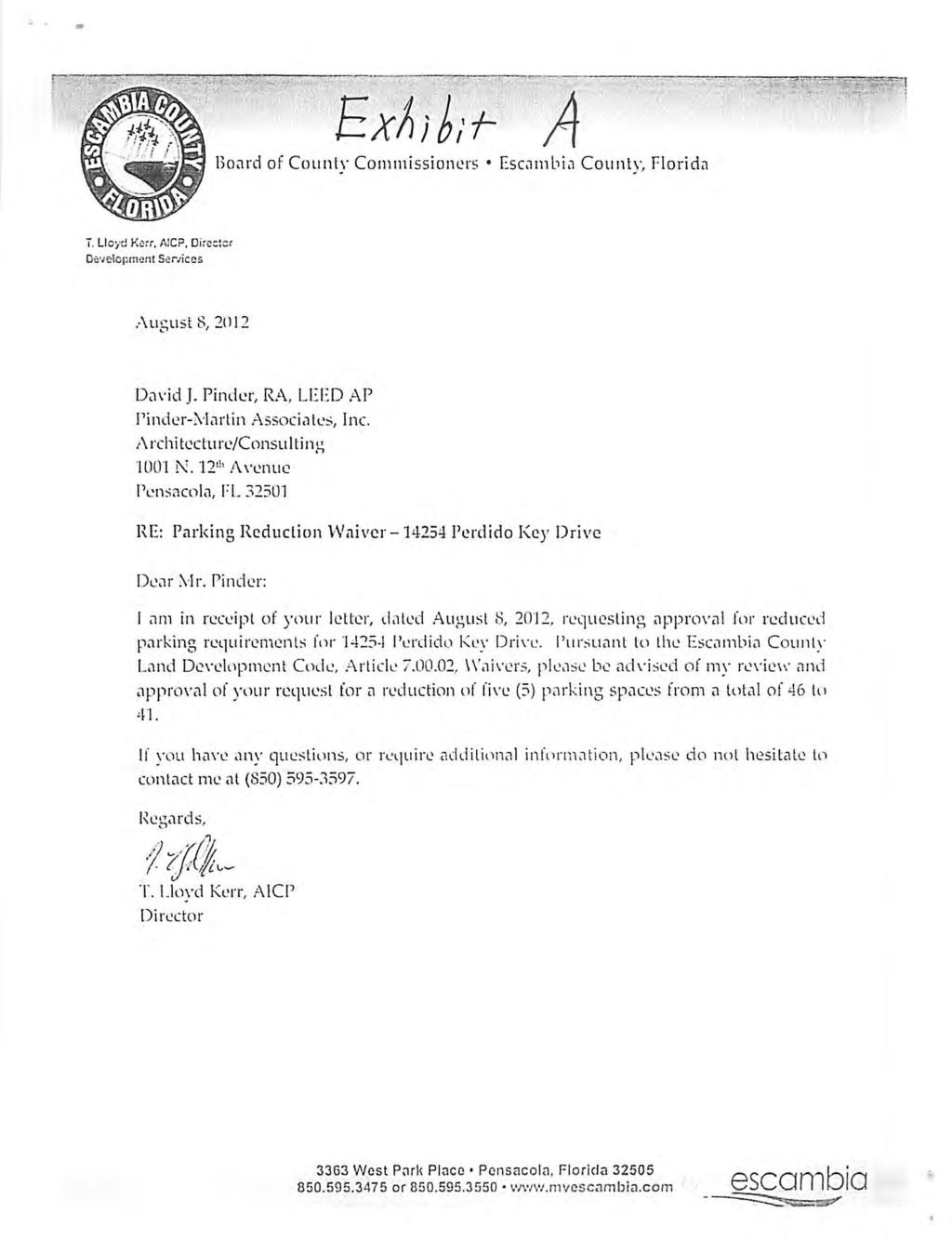
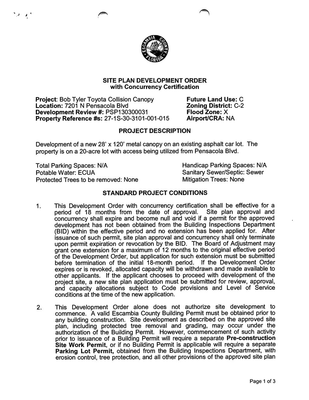
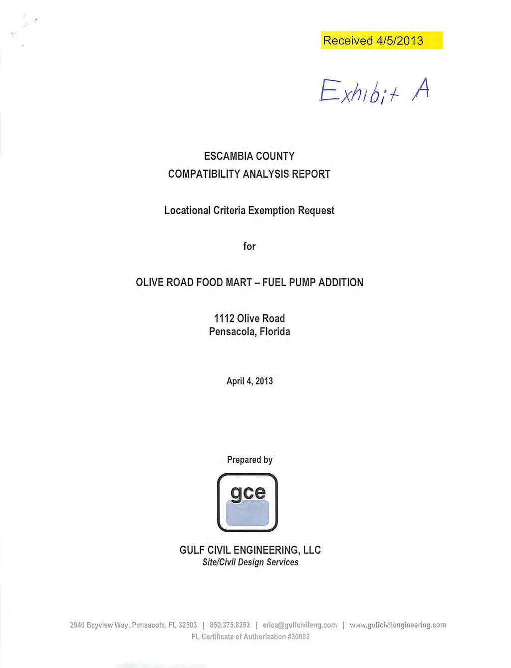
1 SP-Site Plan SPM-Site Plan Minor LPU-Unplateed SD FP-Final Plat D.O.'s not attached owe fees Development Orders Approved in 2013 Type Approved Project Name Address PZ_Proposed_Use # Lots D Units Lodge Units Engr Firm/APPLICANT OWNERS NAME SP 01/02/13 BLACK GOLD OF NORTHWEST FLORIDA 15 BECKS LAKE ROAD ASPHALT PLANT HAMMOND ENGINEERING BLACK GOLD OF NORTHWEST FLORIDA SP 01/16/13 BROWN HELICOPTER WAREHOUSE ADDITION AILERON AVENUE 3600 SF WAREHOUSE ADDITION DAVID FITZPATRICK LOUIS S. BROWN SP 01/16/13 NFCU PARKING LOT EXPANSION 5501 HERITAGE OAKS DRIVE PARKING LOT BASKERVILLE-DONOVAN, INC. NAVY FEDERAL CREDIT UNION SP 01/16/13 DOLLAR GENERAL - NINE MILE 100 E. NINE MILE RD. RETAIL BELL ENGINEERING SERVICES, LLC HENSON JERROLD B & DEBORAH A SP 01/23/13 PENSACOLA FUEL INJECTION WAREHOUSE 4603 N PALAFOX ST NEW WAREHOUE ENVIRONMENTAL ENGINEERING SERVICES PHILLIP WALTERS SP 02/06/13 85 STONE ACCESS RD. 85 STONE BLVD. ACCESS ROAD JEHLE-HALSTEAD STONE, LLC SP 02/06/13 FLORIDA ROCK & TANK LINES TERMINAL (PREVIOUSLY ACME TRANSPORTATION) 147 STUMPFIELD RD TRUCK TERMINAL DAVID LAMAR, P.E. FLORIDA ROCK & TANK SPM 02/13/13 ECUA-CWRF SEPTAGE RECEIVING FACILITY 2890 OLD CHEMSTRAND SEPTAGE RECEIVING FACILITY&CHEMICAL STORAGE AREA BASKERVILLE-DONOVAN,INC EMERALD COAST UTILITIES AUTHORITY SP 02/20/13 NFCU BUILDING B3 AUDITORIUM 5510 HERITAGE OAKS DRIVE AUDITORIUM BASKERVILLE-DONOVAN, INC. NAVY FEDERAL CREDIT UNION SP 02/20/13 MYRTLE GROVE PARK IMPROVEMENTS 99 N 61ST ST PARK IMPROVEMENTS DAVID FITZPATRICK ESCAMBIA COUNTY SPM 02/20/13 FLORA-BAMA OPEN DECK WITH ROOF PERDIDO KEY DRIVE SUPPLY KITCHEN DEAN DALRYMPLE MGFB PROPERITES SP 02/20/13 ECUA-BAYOU MARCUS WRF IMPROVEMENTS 3050 FAYAL DRIVE SITE IMPROVEMENTS BASKEVILLE DONVAN IC ECUA LPU 02/20/13 REAVES/O'DELL UNPLATTED SD 9877 STIRRUP DR UNPLATTED SD JEHLE-HALSTEAD INC. LANCE T REAVES & KIMBERLY R O'DELL SP 02/27/13 L & L SEAFOOD 1611 N. PACE BLVD. RETAIL JEHLE-HALSTEAD INC. LE LINH SP 02/27/13 VERIZON WIRELESS-BRISTOL CREEK TOWER 901 W KINGSFIELD RD COMMUNICATION TOWER SAM, INC. MAC, RAY, REX, RITA TIDWELL SPM 03/06/13 WARD MOTORSPORTS BLUE ANGEL 1440 S BLUE ANGEL PKWY USED AUTO SALES JMA ENGINEERING SERVICES, INC JASON WARD SP 03/06/13 BIG LAGOON LEARNING CENTER ADDITION 5655 BAUER RD DAYCARE DAVID W FITZPATRICK BIG LAGOON LEARNING CENTER SPM 03/06/13 MCARTHUR ELEMENTARY SCHOOL TRACK ADDITION 330 E TEN MILE RD TRACK ADDITION KENNETH HORNE AND ASSOCIATES, INC SCHOOL DISTRICT OF ESCAMBIA COUNTY SPM 03/06/13 WEST FL HIGH SCHOOL-ADVANCED TECH. PARKING LOT ADD LONGLEAF DRIVE PARKING LOT EXPANSION/STORMWATER POND KENNETH HORNE AND ASSOCIATES, INC SCHOOL DISTRICT OF ESCAMBIA COUNTY SPM 03/27/13 MEDITERRANEAN BISTRO, PERDIDO KEY DR RESTAURANT PINDER-MARTIN ASSOCIATES JUNIOR FOOD STORES OF WEST FLORIDA SPM 03/27/13 RACEWAY-FAIRFIELD MODIFICATION 2741 W FAIRFIELD DR 2743 SF SERVICE STATION JEHLE-HALSTEAD RACETRAC PETROLEUM, INC SP 04/03/13 FRESENIUS MEDICAL CLINIC 2940 N BLUE ANGEL PKWY MEDICAL CLINIC GARVER USA YB WEST PENSACOLA LLC SP 04/17/13 BOB TYLER TOYOTA COLLISION CANOPY 7201-C NORTH PENSACOLA BLVD. COLLISION CANOPY MARK CHASTAIN ROBERT TYLER SPM 04/17/13 DELIVERANCE TABERNACLE SCHOOL 8440 ASHLAND AVE SCHOOL GARY BISHOP DELIVERANCE TABERNACLE PAS 04/17/13 OLIVE ROAD FOOD MART INC E OLIVE RD. CONVENIENCE STORE GULF CIVIL ENGINEERING, LLC OLIVE ROAD FOOD MART INC. SP 04/24/13 SOUTHWEST GREENWAY 3RD EXTENSION 1190 DECATUR ST ELEVATED BOARDWALK JEHL-HALSTEAD, INC ESCAMBIA COUNTY WQ&LM DIVISION
2
3
4
5
6
7
8
9
10
11
12
13
14
15
16
17
18
19
20
21
22
23
24
25
26
27
28
29
30
31
32
33
34
35
36
37
38

39
40
41
42
43
44
45
46
47
48
49
50
51

52
53
54
55
56
57
58
59
60
61
62
63
64
65
66
67
68
69
70
71
72
73
74
75
76

77
78
79
80
81
82
83
84
85
86
87
88
89
90
91
92
93
94
95
96
97
98
99
100
101
102
River Realty Services Commercial
 1 4 6 N O R T H U S 9 W, C O N G E R S, N Y 1 0 9 2 0 TA B L E O F C O N T E N T S E X E C U T I V E S U M M A RY 03 Z O N I N G 09 R EG I S T R AT I O N S 04 S U B J EC T P H OTO S 10 M A P V I E W 05
SUBJECT: Limited HTRW Review, Chicago Shoreline, Montrose to Irving
 CELRC-TS-DH MEMORANDUM FOR FILE SUBJECT: Limited HTRW Review, Chicago Shoreline, Montrose to Irving 1. This memorandum documents the results of a limited HTRW review conducted for the Chicago Shoreline
FOR LEASE ±1,800 SF OUTPARCEL NEW CONSTRUCTION, SINGLE TENANT
 FOR LEASE ±1,800 SF OUTPARCEL NEW CONSTRUCTION, SINGLE TENANT DEERFIELD BEACH FL 33441 ROXANNE REGISTER Vice President of Leasing & Sales RoxanneRegister@dkatz.com (561) 869-4346 HIGHLIGHTS Retail only
PROJECTS IN PROGRESS. October 2015
 PROJECTS IN PROGRESS October 2015 DEVELOPMENT UPDATE Village Location Map O N G O I N G P R O J E C T S I N G L E N V I E W 2 DEVELOPMENT UPDATE Village Location Map G L E N P O I N T E I - 2 9 4 & W I
NON-RESIDENTIAL LIGHT MANUFACTURING ZONE DISTRICT (NR-LM)
") NON-RESIDENTIL LIGHT MNUFTURING ZONE DISTRIT () Purpose: The purpose of the zone district is to accommodate moderate-intensity commercial, light assembly, fabrication, and light manufacturing uses, while
NON-RESIDENTIL LIGHT MNUFTURING ZONE DISTRIT () Purpose: The purpose of the zone district is to accommodate moderate-intensity commercial, light assembly, fabrication, and light manufacturing uses, while
FOR SALE +/- 419 ACRES ¼ Mile South of Alliance Airport
 FOR SALE +/- 419 ACRES ¼ Mile South of Alliance Airport Alliance Airport Subject property +/- 419 AC Pat McDowell +1 817 334 8106 pat.mcdowell@am.jll.com JLL 201 Main Street, Suite 1440 Fort Worth, TX
KEY: R-1 Low Density Residential. R-2 Medium Density Residential. R-3 High Density Residential. S-C Service Commercial. D-C Downtown Commercial
 KEY: R-1 Low Density Residential R-2 Medium Density Residential R-3 High Density Residential S-C Service Commercial D-C Downtown Commercial M-C Medical Commercial H-I Heavy Industrial PARKING MATRIX A
ZONING DISTRICT REGULATIONS. Table 4-2 Permitted Uses by Zoning Districts Use Types AG RR R-1 R-2 R-3 MH LC CC DC GC LI GI P Addl Reg
 ZONING DITRICT REGULATION Table 4-2 Permitted Uses by Zoning Districts Agricultural Uses Horticulture P P P P P P P P P 39.06.002a Crop Production P P P 39.06.002a Type I Animal Production Type II Animal
Proposed and Current Development - City of Coral Springs October 2018
 roposed and Current Development - City of Coral Springs October 2018 3 12 10 24 31 35 CORAL RIDGE DR 22 8 33 15 38 11 29 6 ROYAL ALM BLVD LAKEVIEW DR ATLANTIC BLVD CORAL SRINGS DR WESTVIEW DR 18 RIVERSIDE
FLORIDA DIVISION OF EMERGENCY MANAGEMENT STATE WATCH OFFICE DAILY INCIDENT REPORT
 FLORIDA DIVISION OF EMERGENCY MANAGEMENT STATE WATCH OFFICE DAILY INCIDENT REPORT Incident Number: 2018-6310 Incident Name: River Flood Warning (Suwannee River at Fowler Bluff CR 347) Occurred: 10/10/2018
Hurricane Irma. Willis Re Hurricane Damage Survey Report. Executive Summary
 Willis Re Hurricane Damage Survey Report Hurricane Irma Willis Re s post-event field damage survey report Representatives from Willis Re spent four days in the field assessing the damage caused by Hurricane
BOARD OF COUNTY COMMISSIONERS AGENDA ITEM SUMMARY
 7H BOARD OF COUNTY COMMISSIONERS AGENDA ITEM SUMMARY PLACEMENT: REQUESTS AND PRESENTATIONS PRESET: TITLE: PARKS FY 2012 CAPITAL IMPROVEMENT PLAN (CIP) AGENDA ITEM DATES: MEETING DATE: 4/26/2011 COMPLETED
ZONING. 195 Attachment 1
 ZONING 195 Attachment 1 Use Regulation Schedule Town of Chelmsford [Amended 10-16-2000 ATM by Art. 20; 5-3-2001 ATM by Art. 17; 10-15-2001 ATM by Art. 22; 4-29-2002 ATM by Art. 22; 10-24-2002 ATM by Art.
1300 FRANK SINATRA DRIVE
 HUDSON COUNTY HOBOKEN NJ 1300 FRANK SINATRA DRIVE SPACE DETAILS LOCATION Northwest between 13th and 14th Streets GROUND FLOOR SPACE Ground Floor 7,096 SF FRONTAGE 66 FT on Frank Sinatra Drive CEILING HEIGHT
Town of Davie B-2 (Community Business) Zoning:
 Zoning:") Town of Davie B-2 (Community Business) Zoning: Commercial Conservation Districts: These districts are intended to preserve the character of existing nonresidential or commercial areas, neighborhoods and
Town of Davie B-2 (Community Business) Zoning: Commercial Conservation Districts: These districts are intended to preserve the character of existing nonresidential or commercial areas, neighborhoods and
ARTICLE 8. USES 8.0 GENERAL USE PERMISSION 8.1 USE MATRIX 8.2 PRINCIPAL USE STANDARDS 8.3 TEMPORARY USE STANDARDS
 ARTICLE 8. USES 8.0 GENERAL USE PERMISSION 8.1 USE MATRIX 8.2 PRINCIPAL USE STANDARDS 8.3 TEMPORARY USE STANDARDS 8.0 GENERAL USE PERMISSION No structure or land may be used or occupied except in conformity
Information for File # MMJ; Trunk Highway (TH) 7 / Louisiana Ave. Interchange Project
 7 / Louisiana Ave. Interchange Project") Information for File # 2013-00531-MMJ; Trunk Highway (TH) 7 / Louisiana Ave. Interchange Project Applicant: City of St. Louis Park Corps Contact: Melissa Jenny Address: U.S. Army Corps of Engineers Attn:
Information for File # 2013-00531-MMJ; Trunk Highway (TH) 7 / Louisiana Ave. Interchange Project Applicant: City of St. Louis Park Corps Contact: Melissa Jenny Address: U.S. Army Corps of Engineers Attn:
Proposed and Current Development - City of Coral Springs April 2018
 roposed and Current Development - City of Coral Springs April 2018 37 33 18 42 19 25 34 39 40 14 28 26 22 3 12 4 41 6 35 10 8 5 13 9 7 11 CORAL RIDGE DR CORAL SRINGS DR ROYAL ALM BLVD LAKEVIEW DR ATLANTIC
NOTICES OF SHERIFF'S SALE
 Updated: 04/11/19 at 1:12 AM NOTICES OF SHERIFF'S SALE Date & Time of Sale: Thu, Mar 14, 2019 at 1:00 pm Sheriff Sale File number: 87-19-0016-SS Judgment to be Satisfied: $139,685.32 Cause Number: 87C01-1404-MF-000584
NORTHWOOD MIDDLE SCHOOL
 NORTHWOOD MIDDLE SCHOOL Tracking the Panthers INTRODUCTION AND PURPOSE The purpose of this booklet is to provide an answer to the problem of how to get THERE from here. This directory includes all schools
ARTICLE IV GENERAL REGULATIONS Table 4-1 TABLE OF PERMITTED USES
 ARTILE IV GENERAL REGULATIONS Table 4-1 TABLE OF PERMITTED USES ategory Use Agricultural Uses NAIS SDS* Agriculture 1113 P Forestry 113 x P Rural Event Facilities 113 x onventional Subdivision NAIS SDS*
FUND LEDGER. 1 of 6 7:34:02 pm 06/06/2012. THURSTON VILLAGE, FAIRFIELD COUNTY From 05/01/2012 to 05/31/2012
 1 of 6 7:34:02 pm Code : 1000 - General Beginning $50,698.47 $0.00 $50,698.47 05/01/2012 Payroll Memo PAYROLL MEMO EXPENDITURE INTO 1000-710-121-0000 5000012 8870DIRECT MEXP 40-2012 $95.22 $0.00 50,603.25
UA SURVEY CONTROL MONUMENT UA #1 CLEVELAND STREET GARLAND AVENUE. Northing / Easting / Elevation
 #1 Northing 640586.689 / Easting 669419.281 / Elevation 1443.178 Center of bronze cap with UA seal. Located in sidewalk approx. 10 W of curb on Garland Ave. Approx. 24.5 SE of traffic signal post. UA #1
ARTICLE IV GENERAL REGULATIONS Table 4-1 TABLE OF PERMITTED USES
 ARTILE IV GENERAL REGULATIONS Table 4-1 TABLE OF PERMITTED USES ategory Use Agricultural Uses NAIS SDS* Agriculture 1113 P Forestry 113 x P Rural Event Facilities 113 x onventional Subdivision NAIS SDS*
TAX ROLL FOR CITY OF RICHMOND IN THE COUNTY OF, MI FOR THE YEAR 2017 Spec. Population: Ad Valorem+Special Acts
 1/7 Parcel # Valuations Tax Heading Amount Tax Heading Amount --- Totals --- PARCEL #: 7405-006-1001-000 CLASS: 201 SUMMER TAX HEADING AMOUNT WINTER TAX HEADING AMOUNT SUM TAX 4,063.84 SCHOOL: 50180 05
User: Georgina Lopez Pages: 1 of 7 6/1/2018 8:23:49 AM
 Commercial Addition 2018-00000013 Permit Issued AG Welding Brownsville 7475401040008300 $23500 05/08/2018 2800 S DAKOTA AVE $23500 BROWNSVILLE, TX 78520 Due: $000 IDEA Public Schools Canopy Estimated Value:
MAPS AND THEIR CLASSIFICATION
 MAPPING MAPS AND THEIR CLASSIFICATION WHAT IS A MAP? A map is representation of the Earth's surface, showing how things are related to each other by distance, direction, and size. Maps are a way of showing
CHAPTER 12 PLANNING & ZONING ARTICLE 6 - BUSINESS DISTRICT. Section Legal boundary descriptions for central business district.
 CHAPTER 12 PLANNING & ZONING ARTICLE 6 - BUSINESS DISTRICT SECTIONS: Sections 12-6-101 to 199, inclusive. Central business district. Section 12-6-101. Legal boundary descriptions for central business district.
Reed School/Westover Library U USE PERMIT AMENDMENT. Staff Presentation to the County Board November 17, 2018
 Reed School/Westover Library U-3175-07-1 USE PERMIT AMENDMENT Staff Presentation to the County Board November 17, 2018 Site Location 2 Background 1644 N. McKinley Road 1938: Walter Reed Elementary School
D1L ER2 ER3 ER3/4 D2 ER4M ER5M ER6M D2L ER4 ER5 ER6
 L L /4 EM L E M E E E E E E Civic pace Park C C C C C C C C C C C P P Green C C C C C C P P P quare C C P P P P Plaza C C P P P Neighborhood C C C C C C C P C P C Multipurpose Field Playground C C C C
STORMWATER REPORT FRITO LAY SUBDIVISION NO. 3
 STORMWATER REPORT FRITO LAY SUBDIVISION NO. 3 May 2018 STORMWATER REPORT I. Subdivision Data a. The parcel is adjacent to the existing Frito Lay property in Topeka; and the subject plat application encompasses
ORDINANCE NO
 ORDINANCE NO. 174421 VAN NUYS CENTRAL BUSINESS DISTRICT COMMUNITY DESIGN OVERLAY PERMANENT [Q] CONDITIONS ORDINANCE An ordinance AMENDING Section 12.04 of the Los Angeles Municipal Code by amending the
TREASURE COAST REGIONAL PLANNING COUNCIL M E M O R A N D U M. To: Council Members AGENDA ITEM 4B10
 TREASURE COAST REGIONAL PLANNING COUNCIL M E M O R A N D U M To: Council Members AGENDA ITEM 4B10 From: Date: Subject: Staff December 14, 2018 Council Meeting Local Government Comprehensive Plan Review
Rockefeller Group Corporate Center Master Plan
 9,698± AADT 46 wayside dr 97,033± AADT international Pkwy SITE Seminole Towne Center 88,790± AADT Colonial Town Park SITE SPECIFICATIONS is a 28-acre development site strategically located along International
I-94 COMMERCIAL LAND ±30.44 ACRES TH ST Eau Galle, WI 54747
 PROPERTY HIGHLIGHTS + + Located off I-94 and Hwy 63 Interchange 2,900 VPD + + Baldwin-Woodville Area School District + + Zoning: Commercial, Rural Residential + + 40 miles to St. Paul + + 25 miles to Menomonie,
St. Mary s County Comprehensive Zoning Ordinance. Article 5. REGULATION OF USES. Schedule 50.4 Use Classifications. Legend
 St. Mary s County Comprehensive Zoning Ordinance Article 5. REGULATION OF USES Schedule 50.4 Use Classifications Legend P Use is permitted in accordance with Chapter 51 General Standards L Use is permitted
MILWAUKEE AVE & DEERFIELD PKWY
 MILWAUKEE AVE & DEERFIELD PKWY NOTE: ELEVATIONS ARE PRELIMINARY AND ARE SUBJECT TO CHANGE MEREDITH OLIVER BRENDAN REEDY BRENT WAYBURN TRACY FITZGERALD 312.470.1829 312.470.2306 312.470.1828 312.871.5036
Alamito Creek Preserve Ranches for Sale Marfa, Presidio County, Texas
 Alamito Creek Preserve Ranches for Sale Marfa, Presidio County, Texas James King, Agent Office 432 426.2024 Cell 432 386.2821 James@KingLandWater.com Alamito Creek Preserve Various size Ranch Properties,
WATER MANAGEMENT REPORT FOR PAGE ESTATES
 WATER MANAGEMENT REPORT FOR PAGE ESTATES SLB Consulting of SW Florida, LLC PO Box 2826 Bonita Springs, FL. 34133 Phone: 239-948-9566 sandra@slbconsult.com C.O.A. # 25395 September 1, 2014 Sandra L. Bottcher
Tyler Technologies Tax-Wise County Taxation Software
 Time: 09:50:42 RANGES OPTIONS TAX YEAR: (R) 2017-2017 DELINQ. AS OF DATE: 03/21/2019 TAX TYPE: (R) RE - RE REPORT SORT ORDER: N LEVY DISTRICT: REPORT TYPE: D2 TOWNSHIP: COMPLETE LEGAL?: Y RANGE: INCLUDE
City Center West. Twice the flexibility. Two ±106,000 SF Five-Story Class A Buildings A PROJECT BY: 7201 & 7251 WEST LAKE MEAD BOULEVARD FOR LEASE
 A PROJECT BY: Two ±106,000 SF Five-Story Class A Buildings 7201 & 7251 WEST LAKE MEAD BOULEVARD Twice the flexibility www.citycenterwestlv.com 7201 & 7251 WEST LAKE MEAD BOULEVARD 7201 & 7251 West Lake
City Center West. Twice the flexibility. Two ±106,000 SF Five-Story Class A Buildings A PROJECT BY: 7201 & 7251 WEST LAKE MEAD BOULEVARD FOR LEASE
 A PROJECT BY: Two ±106,000 SF Five-Story Class A Buildings FOR LEASE 7201 & 7251 WEST LAKE MEAD BOULEVARD Twice the flexibility www.citycenterwestlv.com 7201 & 7251 WEST LAKE MEAD BOULEVARD 7201 & 7251
Proclaiming Certain Lands as Reservation for the Confederated Tribes of the
 This document is scheduled to be published in the Federal Register on 11/05/2018 and available online at https://federalregister.gov/d/2018-24174, and on govinfo.gov [4337-15] DEPARTMENT OF THE INTERIOR
1 i12 4( H nnd Fl) (2 F Fxhtht I} Pa:e of
 (2 F Fxhtht I} Pa:e of") 28231 11iB9 Exhibit 621A GIS Approved PROPOSED METES AND BOUNDS PD 621 PROPERTY AND SUBDISTRICT DESCRIPTIONS SUBDISTRICT 1 EXCLUDING Planned Development District (PDD) No. 339 (containing 9,865 square
28231 11iB9 Exhibit 621A GIS Approved PROPOSED METES AND BOUNDS PD 621 PROPERTY AND SUBDISTRICT DESCRIPTIONS SUBDISTRICT 1 EXCLUDING Planned Development District (PDD) No. 339 (containing 9,865 square
Trip to National Weather Service & NASA Thursday, June 12, by Claude Cox and Mike Kees
 Trip to National Weather Service & NASA Thursday, June 12, 2014 - by Claude Cox and Mike Kees Nineteen Explorers boarded the County bus at Memorial City Mall on Thursday, June 12th for the day s planned
Zoning Ordinance. Requirements Used Districts R1 R2 R2.6 R3 R4 R5 B1 B2 B3 B4 M1 M2 RH Density Low Low Med Med High High Gen Local CBD Local LT Hvy Ag
 The ordinance shall be known as the Zoning Ordinance of Wetumpka, Alabama, and the map herein referred to as the Zoning Map of Wetumpka, Alabama. The map and all explanatory matter thereon are hereby adopted
Ardaman & Associates, Inc. Geotechnical, Environmental and Materials Consultants
 SUBSURFACE SOIL EXPLORATION 42-INCH FORCE MAIN REPLACEMENT CHIQUITA BOULEVARD S AND SW 34 TH STREET CAPE CORAL, LEE COUNTY, FLORIDA Ardaman & Associates, Inc. Geotechnical, Environmental and Materials
Community Erosion Assessment Napakiak, Alaska 15 January 2008
 1. Community: Napakiak, Alaska Community Erosion Assessment Napakiak, Alaska 15 January 2008 Figure 1: Napakiak Location & Vicinity Map 2. Community Profile Summary: Napakiak is a 2 nd class city of 378
73-2 have been satisfied; and
 RESOLUTION NO. R- 86-104 W'dEREAS, the Board of County Commissioners, as the governing body, pursuant to the authority vested in Chapter 163 and Chapter 125, Florida Statutes, is authorized and empowered
FLORIDA DIVISION OF EMERGENCY MANAGEMENT STATE WATCH OFFICE DAILY INCIDENT REPORT
 FLORIDA DIVISION OF EMERGENCY MANAGEMENT STATE WATCH OFFICE DAILY INCIDENT REPORT Incident Number: 2019-705 Occurred: 2/5/2019 06:00 ET Reported to SWO: 2/5/2019 06:13 ET Affecting: Hillsborough Summary:
Blue Ridge Relay Course Outline. leg distance
 Blue Ridge Relay Course Outline leg leg distance segment distance direction road markers 1 Grayson Highlands State Park Visitors Center 3.90 3.90 S Grayson Highlands State Park Office and Gate 2 S Grayson
EAAA Meeting Agenda May 4, Room 1775
 EAAA Meeting Agenda May 4, 2012 - Room 1775 PROGRAM: IHMC Program: Exploiting the asteroids.... the gold rush in space has begun. Introduction by Wayne Wooten. MEETING The meeting was called to order at
MEMORANDUM. Trip Generation Analysis
 MEMORANDUM To: RMC Architects From: Matthew Palmer, PE Subject: Trip Generation, Parking Analysis & Level of Service Project: Port of Everett, GTC #13-053 Date: August 25, 2014 The trip generation and
Application #: TEXT
 TOWN OF FORT MYERS BEACH 2008 PROPOSED COMPREHENSIVE PLAN AMENDMENTS Application #: 2008-13-TEXT Description: Modify the Coastal Management and Future Land Use Elements to reflect the state s new definition
Shoreline Residential. Neighborhood Residential. Rural Preservation
 Abandoned Building E E E E E E E E E E E E Abandoned Motor Vehicle E E E E E E E E E E E E Accessory Structure E AC P E P (7) P (9) P (10) AC AC AC P P Adult Use E E E E E E E C C E E E Agricultural Use
Erosion Information Paper Eagle City and Eagle Village, Alaska Current as of January 21, 2008
 U.S. Army Corps of Engineers ALASKA BASELINE EROSION ASSESSMENT Erosion Information Paper Eagle City and Eagle Village, Alaska Current as of January 21, 2008 Community Information The City of Eagle, population
UCONN 2000 Year 16 Proposed FY 2011 Authorized Projects Attachment A Storrs & Regional Campuses Project Name Phase III Funding Arjona & Monteith (new
 UCONN 2000 Year 16 Proposed FY 2011 Authorized Projects Attachment A Storrs & Regional Campuses Project Name Phase III Funding Arjona & Monteith (new classroom buildings) $ 45,900,000 Avery Point Campus
YTD Check Register Dalhart ISD Sort by Check Number
 Page 1 of 9 002099 002100 002101 002102 026850 03-07-2014 00180 BLUE BELL CREAMERIES, L. 240-35-6341.00-001-499000 C SNACK BAR SUPPLIES 220.23 240-35-6341.00-042-499000 SNACK BAR SUPPLIES 330.72 002099
GRB QUICK REFERENCE: Contact Information.
 1 GEORGE R. BROWN C O N V E N T I O N C E N T E R WITH A VIBRANT DOWNTOWN, a walkable convention district and one of the largest convention facilities in America, there has never been a better time to
P P P P P P P P P X Agricultural Processing
 Residential Uses Medical Hardship Modular Homes Mobile Home (Single) Mobile Home (Double) Mobile Home Park Multi-Family Planned Unit Development Second Dwelling Single Family dwellings Site Built Homes
PUBLIC UTILITY COMMISSION OF TEXAS DOCKET NO
 Application of CenterPoint Energy Houston Electric, LLC for a Certificate of Convenience and Necessity for a Proposed 138 kv Transmission Line within Harris County, Texas PUBLIC UTILITY COMMISSION OF TEXAS
Alameda County Facilities
 www.canhr.org 650 Harrison Street, 2nd Floor San Francisco, CA 94107 (800) 474-1116 (Consumers) (415) 974-5171 California Advocates for Nursing Home Reform Consumer Information Service Alameda County Facilities
Attachment A. Page 1 of 15
 Page 1 of 15 EXECUTIVE SUMMARY The purpose of this study was to conduct a parking market rate analysis of pay parking facilities surrounding the Manchester area. The market rate analysis was conducted
Robert s Village. The Shops at Aubert Avenue Saint Louis, Missouri 63113
 The Shops at Robert s Village 1330 Aubert Avenue Saint Louis, Missouri 63113 Jeff Eisenberg P: (314) 721-5611 C: (314) 640-8510 jeff@jeisenberg.com www.jeisenberg.com FOR LEASE Roberts Village Shopping
G.1. Motion to approve Project Calendar regarding Planning and Development Department Payments as follows:
 G.1.a council memo DATE: Wednesday, January 31, 2018 TO: FROM: RE: Mayor and City Council Tracey Bellach, Administrative Assistant G.1. Motion to approve Project Calendar regarding Planning and Development
NICOLE FONTAINE JON CASHION N. Ocean avenue singer island, FL Director of Leasing & Sales. Senior Director of Leasing & Investment Sales
 for lease ocean front retail 2401 N. Ocean avenue singer island, FL 33404 JON CASHION Senior Director of Leasing & Investment Sales JonCashion@dkatz.com (561) 869-4342 Licensed Florida Broker NICOLE FONTAINE
CITY OF PAPILLION PLANNING COMMISSION STAFF REPORT MAY 27, 2015 AGENDA 2015 ANNEXATION MISC
 PLANNING COMMISSION STAFF REPORT MAY 27, 2015 AGENDA 2015 ANNEXATION MISC-15-0005 I. GENERAL INFORMATION A. APPLICANT: City of Papillion 122 East Third St. Papillion, NE 68046 B. LEGAL DESCRIPTION: See
FUND LEDGER. From 07/01/2006 to 07/31/2006. Total Fund Balance Fund: General Fund Beginning Balance $22, $15, $37,785.
 Page: 1 Code : 1000 - General Beginning $22,731.76 $15,053.62 $37,785.38 07/01/2006 Payroll Memo PAYROLL MEMO EXPENDITURE INTO 1000-710-121-0000 7000037 8870DIRECT MEXP 45-2006 $590.60 $0.00 22,141.16
Cincinnati Industrial listing summary
 AERIAL MARCH 2014 L OREAL 75 GSI COMMERCE LOGISTICS BLVD. 71 BUILDING H 631,448 SF CUMMINS BUILDING A 754,800 SF BUILDING B 1,197,000 SF TRANSPORT DRIVE.75 mile DIXIE HWY. 25 2101-2301 E. KEMPER ROAD ::
ACTIVE SINGLE FAMILY SUBDIVISIONS CITY OF BURLESON January 2011
 ACTIVE SINGLE FAMILY SUBDIVISIONS CITY OF BURLESON January 2011 SUBDIVISION TOTAL LOTS VACANT LOTS ALSBURY ESTATES EAST - PHASE II 45 1 ALSBURY MEADOWS - PHASE II 112 1 BROAD VALLEY FARMS 1 2 CASTLE HILL
UNION MINIERE EXPLORATIONS AND MINING CORPORATION LIMITED 1 GROUP OF MINERAL CLAIMS. Liard Mining Division, British Columbia
 UNION MINIERE EXPLORATIONS AND MINING CORPORATION LIMITED SUITE 200-4299 CANADA WAY BURNABY. RC. V5G 1 H4 TELEPHONE 437-949 1 - Z ASSESSMENT REPORT ON DIAMOND DRILLING ON THE CLAW NO. 1 GROUP OF MINERAL
STREET LIGHTING AUSTIN ENERGY ILLUMINATION DEPARTMENT
 STREET LIGHTING AUSTIN ENERGY ILLUMINATION DEPARTMENT http://www.austinenergy.com/ Physical Address: 4411 Meinardus Drive Austin, Texas 78744 Hours of Operation: Monday Friday 6am to 3pm Key Contact: Joyce
NOA ASSESSMENT HARRIS QUARRY MENDOCINO COUNTY, CALIFORNIA TABLE OF CONTENTS
 NOA ASSESSMENT HARRIS QUARRY MENDOCINO COUNTY, CALIFORNIA TABLE OF CONTENTS Introduction... 1 Scope of Services... 1 Project Location and Description... 1 Geologic Setting... 1 Regional Geology... 1 Site
1951 Flood Photograph Collection
 1951 Flood Photograph Collection This collection of 30 photographs provides images of the 1951 flood taken in the Kansas City area. Descriptive Summary Creator: Unknown Title: 1951 Flood photograph collection
Major Point/Area Sources Name Type Major Emissions Distance (m) Direction CFB Cold Lake Air Force Base NOx, PM, HC, TRS 3km to aircraft West
 Direction CFB Cold Lake Air Force Base NOx, PM, HC, TRS 3km to aircraft West") Page 1 of 11 Site Documentation: Cold Lake South Continuous Monitoring Station General Site Information Item Description Site ID (CASA ID) LICA01 Station Name Cold Lake South Continuous Monitoring Station
Page 1 of 11 Site Documentation: Cold Lake South Continuous Monitoring Station General Site Information Item Description Site ID (CASA ID) LICA01 Station Name Cold Lake South Continuous Monitoring Station
[Leveraging & Improving Neighborhood Connections] Area E Cedar Creek
![[Leveraging & Improving Neighborhood Connections] Area E Cedar Creek](/thumbs/86/93508963.jpg "[Leveraging & Improving Neighborhood Connections] Area E Cedar Creek") Community Charrette LINC Dallas [Leveraging & Improving Neighborhood Connections] Area E Cedar Creek 06.02.12 LINC Workshop Area E Area E has the unique distinction of at-grade frontage to the Trinity
Community Charrette LINC Dallas [Leveraging & Improving Neighborhood Connections] Area E Cedar Creek 06.02.12 LINC Workshop Area E Area E has the unique distinction of at-grade frontage to the Trinity
Sewer Area Study. TR No (FOR OUTLET POINTS 1 & 2) January 5, 2016 JN PC11775AS SEWER AREA STUDY APPROVED /08/2016
 January 5, 2016 JN PC11775AS SEWER AREA STUDY APPROVED /08/2016") Sewer Area Study TR No 53138 (FOR OUTLET POINTS 1 & 2) January 5, 2016 JN 99610-01 PC11775AS SEWER AREA STUDY APPROVED APPROVED BY: RCE NO. DATE 70745 03/08/2016 CHECKED BY: DATE Imelda Ng 03/08/2016 COUNTY
Sewer Area Study TR No 53138 (FOR OUTLET POINTS 1 & 2) January 5, 2016 JN 99610-01 PC11775AS SEWER AREA STUDY APPROVED APPROVED BY: RCE NO. DATE 70745 03/08/2016 CHECKED BY: DATE Imelda Ng 03/08/2016 COUNTY
CONGLETON INDUSTRIAL PARK LT 6 EX W 300' & E 350' LT 7 BLK 1, a subdivision of land in the City of Overland Park, Johnson County, Kansas.
 NOTICE OF PUBLIC HEARING CITY PLANNING COMMISSION CITY OF OVERLAND PARK, KANSAS Notice is hereby given that the City Planning Commission of Overland Park, Kansas, will hold a public hearing Monday, July
TAX INCREMENT FINANCING DISTRICT CREDITS TO BE PAID TO COUNTIES, CITIES OR TOWNSHIPS ON DECEMBER 26TH, 2012 (SEE LAST PAGE FOR COUNTY DISTRICTS)
") TAX INCREMENT FINANCING RICT S (SEE LAST PAGE FOR RICTS) NAME ANOKA ANOKA CITY OF 688 001 ANOKA - REDEV 2 (E9) 201 0 0 0 0 0 ANOKA ANOKA CITY OF 688 002 ANOKA - D THURSTON AVE CORRIDOR (H8) 286 0 0 0 0
TAX INCREMENT FINANCING RICT S (SEE LAST PAGE FOR RICTS) NAME ANOKA ANOKA CITY OF 688 001 ANOKA - REDEV 2 (E9) 201 0 0 0 0 0 ANOKA ANOKA CITY OF 688 002 ANOKA - D THURSTON AVE CORRIDOR (H8) 286 0 0 0 0
...TORNADO CONFIRMED NEAR SANFORD...BROADWAY...HOLLY SPRINGS AND RALEIGH IN LEE AND WAKE COUNTIES COUNTY NORTH CAROLINA...
 ...TORNADO CONFIRMED NEAR SANFORD...BROADWAY...HOLLY SPRINGS AND RALEIGH IN LEE AND WAKE COUNTIES COUNTY NORTH CAROLINA... LOCATION...SANFORD...BROADWAY...HOLLY SPRINGS AND RALEIGH IN LEE AND WAKE COUNTIES
Erosion Information Paper - South Naknek, Alaska Current as of November 14, 2007
 U.S. Army Corps of Engineers ALASKA BASELINE EROSION ASSESSMENT Erosion Information Paper - South Naknek, Alaska Current as of November 14, 2007 Community Information South Naknek (NACK-neck), originally
Winning Farm of Winchester
 Winning Farm of Winchester Planning Board Presentation Winning Farm of Winchester 12.9 acres of undeveloped forest on the former Winning Farm site Located north of Thornberry Road in the northwestern corner
December 16, Mr. Lee Hughes Southwest Florida Water Management District Tampa Service Office 7601 Highway 301 North Tampa, FL 33637
 December 16, 2015 Mr. Lee Hughes Southwest Florida Water Management District Tampa Service Office 7601 Highway 301 North Tampa, FL 33637 RE: Response to SWFWMD Supplemental Information Request Dear Mr.
FINAL UTILITY REPORT Creekside Thornton, CO
 FINAL UTILITY REPORT Creekside Thornton, CO March 4, 216 Revised: June 27, 216 JN: 1539 Prepared for: HW Sodbusters, LLC 2733 E. Parleys Way, Suite 3 Salt Lake City, UT 8419 P: 81.485.777 Prepared by:
GLM & Associates. February 9, 2018
 GLM & Associates Geoffrey L. Maddux Environmental Consultant 7497 Harvest Village Court P.O. Box 5339 Navarre, Florida 32566 (850) 939-8037, Fax (850) 939-8037 February 9, 2018 Ms. Dawn Templin, P.E. Florida
Case Special Exception request for Planned Unit Development (PUD) The Vineyards
 The Vineyards") Case 1627 Applicant: Developer: Request: Location: Pointe South Land Trust Contact Information: Jimmy Garrett 901-271-3642 N/A Special Exception request for Planned Unit Development (PUD) The Vineyards
Case 1627 Applicant: Developer: Request: Location: Pointe South Land Trust Contact Information: Jimmy Garrett 901-271-3642 N/A Special Exception request for Planned Unit Development (PUD) The Vineyards
BRANDON LAKES AVENUE PRE AND POST CONDITIONS DRAINAGE REPORT
 BRANDON LAKES AVENUE PRE AND POST CONDITIONS DRAINAGE REPORT Hillsborough County Public Works County Center, 22nd Floor 601 E. Kennedy Blvd. Tampa, FL 33602 BRANDON LAKES AVENUE DRAINAGE IMPROVEMENTS Capital
May 22, Mr. Tim Tyler TRWME Properties, LLC 240 Hwy. 65 N Conway, AR RE: Royal Oaks Vista Subdivision Site. Dear Mr.
 May 22, 2008 Mr. Tim Tyler TRWME Properties, LLC 240 Hwy. 65 N Conway, AR 72032 RE: Royal Oaks Vista Subdivision Site AFIN: 12-00272 NPDES Permit No.: ARR150472 Dear Mr. Tyler: On March 26, 2008, I performed
Portland, Oregon P O R T L A N D O R E G O N. G O V / T R A N S P O R T A T I O N 1
 Portland, Oregon P O R T L A N D O R E G O N. G O V / T R A N S P O R T A T I O N 1 Portland Christchurch Credit: Travel Portland P O R T L A N D O R E G O N. G O V / T R A N S P O R T A T I O N 2 Portland,
SOUTHEAST PLANT POWER FEED AND PRIMARY SWITCHGEAR UPGRADES CIVIC DESIGN REVIEW - PHASE 1 - NOVEMBER 14, 2016
 SOUTHEAST PLANT POWER FEED AND PRIMARY SWITCHGEAR UPGRADES CIVIC DESIGN REVIEW - PHASE 1 - NOVEMBER 14, 2016 CITY & COUNTY OF SAN FRANCISCO PUBLIC UTILITIES COMMISSION PROJECT LOCATION CALTRAIN RAILROAD
About places and/or important events Landmarks Maps How the land is, hills or flat or mountain range Connected to maps World Different countries
 What do you think you know about geography? About places and/or important events Landmarks Maps How the land is, hills or flat or mountain range Connected to maps World Different countries What do you
Planning & Zoning Commission
 Request Applicant Owner Zoning Location Attachments Subdivision of 50.03 acres of previously unplatted property to create one lot for the construction of a K-6 th Grade Education Village for Dickinson
TMRC 2016 The 27th Magnetic Recording Conference
 TMRC 2016 The 27th Magnetic Recording Conference Jen-Hsun Huang Engineering NVIDIA Auditorium, Basement Floor August 17-19, 2016 Directions to Event Parking From US 101: Take the Embarcadero Road exit
Rendering. White Plains Rd & Turnbull Ave, Bronx NY BRUCKNER COMMONS. June B. Fisher
 BRUCKNER COONS White Plains Rd & Turnbull Ave, Bronx NY 1043 LEASING: June B. Fisher 201.51.3510 jufisher@uedge.com BRUCKNER COONS PROPERTY HIGHLIGHTS 1 mile LOCATION White Plains Road & Turnbull Avenue
BUILDING PERMITS FOR NEW RESIDENTIAL CONSTRUCTION, BY TYPE, CENSUS TRACT, AND SUBDIVISION, KANSAS CITY, KANSAS (2010)
") BUILDING PERMITS FOR NEW RESIDENTIAL CONSTRUCTION, BY TYPE, CENSUS TRACT, AND SUBDIVISION, KANSAS CITY, KANSAS (2010) Finance Department, Research Division May 2011 BUILDING PERMITS FOR NEW RESIDENTIAL
BUILDING PERMITS FOR NEW RESIDENTIAL CONSTRUCTION, BY TYPE, CENSUS TRACT, AND SUBDIVISION, KANSAS CITY, KANSAS (2010) Finance Department, Research Division May 2011 BUILDING PERMITS FOR NEW RESIDENTIAL
TMRC 2016 The 27th Magnetic Recording Conference
 TMRC 2016 The 27th Magnetic Recording Conference Jen-Hsun Huang Engineering NVIDIA Auditorium, Basement Floor August 17-19, 2016 Directions to Event Parking From US 101: Take the Embarcadero Road exit
THE TRINITY RIVER VISION/ GATEWAY PARK / PANTHER ISLAND Flood Control Project Update
 Quarterly Project Status Report September 2018 THE TRINITY RIVER VISION/ GATEWAY PARK / PANTHER ISLAND Flood Control Project Update TxDot s contractor has nearly completed the superstructure false work
PUP R-4 R-3 R-4 R-3 R-4 B-1 B-3 B-1 B-1 B-1 R-3 C-1 R-3 R-3 A-1 M-2C SUBJECT PROPERTY B-3 R-5 B-3C B-3C B-3C B-3C B-2.
 0 0 0 0 0 00 0 EARLY AVE 00 0 0 0 0 0 R- 0 0 0 C- 0 0 0 0 0 0 R- 0 B- 00 0 0 0 0 0 0 CARTER AVE EAST SIDE LN 0 0 0 JACKSON AVE 00 0 0 A- Parcels or Portions thereof identified on this sheet are within
1. Departmental Presentation - Away Goes Trouble Down the Drain - Highway Division. 3. Continued Discussion an Ordinance for Disorderly Residences
 City of Keene New Hampshire MUNICIPAL SERVICES, FACILITIES AND INFRASTRUCTURE COMMITTEE AGENDA Council Chambers B October 11, 2017 6:00 PM Janis O. Manwaring Randy L. Filiault Robert J. O'Connor Stephen
...TORNADO CONFIRMED NEAR SANFORD...BROADWAY...HOLLY SPRINGS AND RALEIGH IN LEE AND WAKE COUNTIES COUNTY NORTH CAROLINA...
 ...TORNADO CONFIRMED NEAR SANFORD...BROADWAY...HOLLY SPRINGS AND RALEIGH IN LEE AND WAKE COUNTIES COUNTY NORTH CAROLINA... LOCATION...SANFORD...BROADWAY...HOLLY SPRINGS AND RALEIGH IN LEE AND WAKE COUNTIES