MONITORING OF THE FREEZING DANUBE DELTA BASED ON SENTINEL-1/2 IMAGERY
|
|
|
- Adela Atkinson
- 5 years ago
- Views:
Transcription

1 Journal of Young Scientist, Volume V, 2017 ISSN ; ISSN CD-ROM ; ISSN Online ; ISSN-L MONITORING OF THE FREEZING DANUBE DELTA BASED ON SENTINEL-1/2 IMAGERY Giulia-Laura PANTEA, Anca-Simona LACUSTEANU Scientific Coordinator: Lect. PhD Iulia DANA NEGULA University of Agronomic Sciences and Veterinary Medicine of Bucharest, 59 Mărăşti Blvd, District 1, , Bucharest, Romania, Phone: , Fax: , giulia.pantea123@gmail.com; ancaanka27@yahoo.com; iulia.dana@fifim.ro Abstract Corresponding author giulia.pantea123@gmail.com In January 2017, extremely low temperatures caused the freezing of the Danube Delta, leading to the complete isolation of some villages for a couple of weeks. The area was monitored from space, based on images acquired by Sentinel-1 and Sentinel-2, two satellite missions launched in the frame of the European Programme Copernicus. Sentinel-1 is equipped with a C-band synthetic aperture radar, while Sentinel-2 has a multi-spectral optical sensor acquiring data in 13 spectral bands. The spatial resolution of the GRD (Ground Range Detected) Sentinel-1 products used in this study is 10 meters, while the spatial resolution of the MSI (Multi-Spectral Instrument) Sentinel-2 products is 10 m, 20 m and 60 m, depending on the spectral band (B2, B3, B4, B8 highest resolution, B5, B6, B7, B8a, B11, B12 medium resolution and B1, B9, B10 lowest resolution). The Sentinel-1/2 satellites collect complementary information that can be used for the frequent monitoring of vast areas, given the fact that each mission is composed of a pair of satellites (Sentinel-1A/B and Sentinel-2A/B). Sentinel-2B was launched on the 7 th of March 2017 and it is currently in the commissioning phase. The present study aims at promoting the usefulness and adequacy of satellite data for monitoring the situation on the ground, especially when the area is not accessible by other means. Key words:danube Delta, freezing temperatures,satellite imagery, Sentinel-1/2. INTRODUCTION The Danube River (Figure 1) is considered the most international river on the planet due to the fact that its course runs across or forms a part of the borders of several countries: Germany, Austria, Slovakia, Hungary, Croatia, Serbia, Romania, Bulgaria, Ukraine, and four capitals: Vienna, Bratislava, Budapest and Belgrade ( classified as a biosphere reserve and as a national park in Romania. The Delta is formed around the three main channels of the Danube, named after their respective ports: Chilia - in the north, Sulina - in the middle, and Sfantu Gheorghe - in the south ( com/danube-delta.html). Figure 1. Danube River Basin ( WWF 2017) The Danube Delta (Figure 2) entered the UNESCO World Heritage List in 1991, being 213 Figure 2. Danube Delta (UNESCO Marciela) According to the UNESCO official description of the Natural Heritage Site, "the waters of the Danube, which flow into the Black Sea, form
2 the largest and best preserved of Europe's deltas. The Danube delta hosts over 300 species of birds as well as 45 freshwater fish species in its numerous lakes and marshes" ( unesco.org/en/list/588). This year, the Danube Delta region experienced one of the harshest winters on record. Temperatures plummeted to -20 C, encasing landscapes in a thick coat of frozen water. Because of the low temperatures the area was completely isolated, and ships could not sail because floes were impenetrable, according to the local media ( and According to the historic records, the lowest value was recorded at Constanta in 1929 when the mercury thermometer dropped to -250C, but winters were heavy too in 1954, 1963, 1985 or In 1929, the Black Sea froze over five kilometres, causing a compact ice blanket. Due to those low temperatures the city of Constanta received the name "Little Siberia". This year s low temperatures in Dobrogea made the Black Sea to freeze over a distance of 100 metres offshore. Beyond the major ice sheet on the sea, other large pieces of ice were observed. This freezing phenomena has proven that the Black Sea is one of the least salty sea in the world. In the case of the Black Sea, salinity values fall between compared to 35 for the Mediterranean Sea. The last time Black Sea was covered with a layer of ice was five years ago. According to the meteorologists, in the first decade of January 2017 (the time frame for the present study) the temperatures ranged from -160C to - 220C. On the 1st of January, at 8:00 AM, the sea temperature was between -20C and +20C and the air temperature ranged from -140C to - 160C, so that the surface layer of the sea water vaporized on the contact with the cold air, giving the impression that the sea "boils". This phenomenon of extreme frost rarely occurs only in areas where depths are relatively small along the coastline. On the other hand, the sudden temperature changes are due to global warming, which caused the reducing of the amount of ice in the Arctic. The blocks of ice appeared to have a considerable thickness for 25 days ( /inbulgaria-for-the-first-time-in-60-years-frozenblack-sea.html).in the case of the present study, satellite images acquired by Sentinel-1 and Sentinel-2 were selected, downloaded from the Copernicus Open Access HUB ( and processed using the open source software SNAP-Sentinel Application Platform. Sentinel-1 is the first satellite launched in the frame of Copernicus - European Programme for Environmental and Security monitoring. MATERIALS AND METHODS Sea ice is a rapidly changing phenomenon. Timely measurements over large areas, at high spatial and temporal resolutions, are fundamental for its surveillance. Thus, the identification of risks and opportunities, such as the opening of shipping lanes, are possible thanks to satellite monitoring of sea ice ( rth/cryosat/sea_ice). For example, since 2015, following the various MyOcean programmes that first started back in 2009, the Copernicus Marine Environment Monitoring Service (CMEMS) has been providing regular and systematic reference information on the physical state, variability and dynamics of the ocean and marine ecosystems, for the world's oceans and Europe's seas. The observations and forecasts produced by the CMEMS service support all marine applications. For instance, the provision of data on currents, winds and sea ice help to improve ship routing services, offshore operations and search and rescue operations, thus contributing to marine safety ( marine.copernicus.eu/). From the satellite images, analysts are able to extract how much ice there is over areas of interest and how thick it is, so that ice charts can be used to select the safest routes. Satellites provide the majority of information about the development of ice conditions in the Arctic. Sentinel-1(Figure 3) is equipped with a C-band synthetic aperture radar (SAR) that is capable of monitoring irrespective of cloud cover or light conditions, makes it possible to observe sea ice with higher reliability than optical methods and with better resolution than passive microwave ones. The spatial resolution of the GRD (Ground Range Detected) Sentinel-1 products used in this study is 10 meters. The 214
 has a multi-spectral optical sensor acquiring data in 13 spectral bands.")
.")
3 Sentinel-1 mission details are provided in Table 1 ( Sentinel-2 (Figure 4) has a multi-spectral optical sensor acquiring data in 13 spectral bands. The spatial resolution of the GRD (Ground Range Detected) Sentinel-1 products used in this study is 10 meters, while the spatial resolution of the MSI (Multi-Spectral Instrument) Sentinel-2 products is 10 m, 20 m and 60 m, depending on the spectral band (B2, B3, B4, B8 highest resolution, B5, B6, B7, B8a, B11, B12 medium resolution and B1, B9, B10 lowest resolution). Sentinel-2 mission details are provided in Table 2. Figure 3. Sentinel-1 on orbit ( ESA 2017) Table 1. Characteristics of the Sentinel-1 mission Satellite Launch date Orbit type and altitude Sentinel-1A 03 April 2014 Near-polar, sun-synchronous, Sentinel-1B 25 April km, inclination Sentinel-2 is a multispectral operational imaging mission within the Copernicus, former GMES (Global Monitoring for Environment and Security) Programme, jointly implemented by the EC (European Commission) and ESA for global land observation (data on vegetation, soil and water cover for land, inland waterways and coastal areas, and also provide atmospheric absorption and distortion data corrections) at high resolution with high revisit capability to provide enhanced continuity. The satellite requires excellent pointing accuracy and stability and, therefore, high-end orbit and attitude control sensors and actuators. The multispectral imager is the most advanced of its kind, integrating two large visible nearinfrared and shortwave infrared focal planes, each equipped with 12 detectors and integrating 450,000 pixels. Pixels that may fail in the course of the mission can be replaced by redundant pixels. Two kinds of detectors integrate high-quality filters to isolate the spectral bands perfectly. The instrument's optomechanical stability must be extremely high, which has meant the use of silicon carbide ceramic for its three mirrors and focal plane, and for the telescope structure itself ( esa-operational-eo-missions/sentinel-2). Figure 4. Sentinel-2 on orbit ( ESA 2017) Table 2. Characteristics of the Sentinel-2 mission Satellite Launch date Orbit type and altitude Sentinel-2A 23 June 2015 Near-polar, sun-synchronous, Sentinel-2B 07 March km, inclination In the present study, two satellite images were downloaded from the Copernicus Open Access HUB. The Sentinel-1 image was acquired on the 9th of January, while the Sentinel-2 image was acquired on the 13th of January. The following processing steps were applied for the processing of the GRD Sentinel-1 image: orbit file application, calibration, speckle filtering and geocoding (based on a DEM). In case of the level-1c Sentinel-2 image, the data contain top-of-atmosphere reflectances in cartographic geometry. RESULTS AND DISCUSSIONS The following image windows illustrate some instances of the freezing Danube Delta, both in Sentinel-1 and Sentinel-2 imagery. Figures 5-8 are samples of Sentinel-1 data showing rivers parts unaffected by ice, while figures 9-15 illustrate ice floes, both on Sentinel-1 and

 Figure 6.")
 Figure")

 Figure")

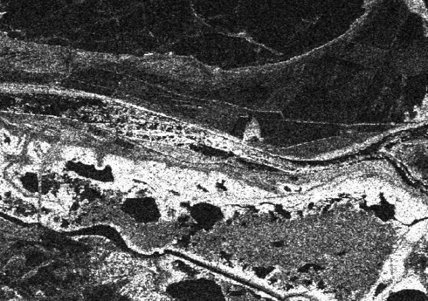

4 Figure 5. Processed Sentinel-1 image river area without ice floes (example 1) Figure 9. Processed Sentinel-1 image river area with ice floes (example 1) Figure 6. Processed Sentinel-1 image river area without ice floes (example 2) Figure 10. Processed Sentinel-1 image river area with ice floes (example 2) Figure 7. Processed Sentinel-1 image river area without ice floes (example 3) Figure 11. Processed Sentinel-1 image river area with ice floes (example 3) Figure 8. Processed Sentinel-1 image river area without ice floes (example 4) Figure 12. Processed Sentinel-1 image river area with ice floes (example 4) 216
 river area with ice floes (example 2) Figure 15. Sentinel-2 image (natural colours) river area with ice floes (example 3) Figure 16.")


5 Figure 13. Sentinel-2 image (false colour infrared) river areawith ice floes (example 1) Figure 17. Sentinel-2 image (false colour infrared) Sinoe Lake CONCLUSIONS Figure 14. Sentinel-2 image (false colour infrared) river area with ice floes (example 2) Figure 15. Sentinel-2 image (natural colours) river area with ice floes (example 3) Figure 16. Sentinel-2 image (false colour infrared) Razim Lake 217 Satellite data are the optimal solution for monitoring very large areas. The high spatial and spectral resolution of Sentinel enable the detailed monitoring of the different features on the ground, such as large blocks of ice on the navigable channels. With the great advantage of being free and immediately available for the users, Sentinel data can provide critical information for the responsible authorities, just by using visual interpretation without any advanced processing tools. Within the Copernicus Programme, ESA offers free and open access to Sentinel imagery and to data processing tools as well. Earth Observation data offer necessary information for emergency and disaster management. Satellite remote sensing data and its derived products are essential components in the management of emergency situations. The integration of ancillary data improves the quality and content of the disaster crisis maps offering the guarantee of the in situ collected basic information. The knowledge of the studied area, from the geographical point of view, is vital. A monitoring service for the Danube River and the Danube Delta can be successfully developed based on Sentinel data, considering the large number of interested parties, i.e. private and public port and marina operators, security, law enforcement and defence agencies, border control, commercial and leisure mariners, harbour responsible authorities, marine insurers, national naval authorities, fishermen organisations and last but not least, scientists from oceanography, riverine and marine environment and ecology.
6 REFERENCES AGERPRES: Tulcea Traficul navelor fluvial pe Dunare, afectat de sloiuri, social/2017/01/08/tulcea-traficul-navelor-fluviale-pedunare-afectat-de-sloiuri Copernicus Marine Monitoring Service, copernicus.eu/, Copernicus Open Access Hub Open Hub, scihub. copernicus.eu/, ESA: Black Sea From Space Workshop conferencebureau.com/2016-events/16c17---n-blacksea/background, ESA Earth Online: What is Seninel-1? accessed March ESA Earth Online: What is Seninel-2? esaoperational-eo-missions/sentinel-2, accessed March European Space Agency: Observing the Earth - Cryosat rth/cryosat/sea_ice, Romania: Natural and Cultural, The Danube Delta, The Earth Chronicles of Life International News. -first-time-in-60-years-frozen-black-sea.html, UNESCO: World Heritage List, Danube Delta description, Ziarul de Tulcea: Apele din Delta Dunării Oameni aflaţi în situaţii de maximă urgenţă medical rămân captive între apele îngheţate ale Dunării, 218
CopernicusEU. the EU's Earth Observation Programme. Sara Zennaro Atre Delegation of the European Union to Japan
 Copernicus the EU's Earth Observation Programme Sara Zennaro Atre Delegation of the European Union to Japan Status Overview, Sept 2016 & Ocean Policies Seminar 4 October 2016 ollow us on: Copernicus EU
sentinel-2 COLOUR VISION FOR COPERNICUS
 sentinel-2 COLOUR VISION FOR COPERNICUS SATELLITES TO SERVE By providing a set of key information services for a wide range of practical applications, Europe s Copernicus programme is providing a step
sentinel-3 A BIGGER PICTURE FOR COPERNICUS
 sentinel-3 A BIGGER PICTURE FOR COPERNICUS SATELLITES TO SERVE By providing a set of key information services for a wide range of practical applications, Europe s Copernicus programme has been put in place
Copernicus Today and Tomorrow GEO Week Group on Earth Observation Geneva, 16 January 2014 The Copernicus Space Infrastructure
 Copernicus Today and Tomorrow GEO Week Group on Earth Observation Geneva, 16 January 2014 The Copernicus Space Infrastructure Thomas Beer, Policy Coordinator, Copernicus Space Office, ESA-ESRIN, Frascati
Infrastructure monitoring using SAR interferometry
 Infrastructure monitoring using SAR interferometry Hossein Nahavandchi Roghayeh Shamshiri Norwegian University of Science and Technology (NTNU), Department of Civil and Environmental Engineering Geodesy
Effective Utilization of Synthetic Aperture Radar (SAR) Imagery in Rapid Damage Assessment
 Imagery in Rapid Damage Assessment") Effective Utilization of Synthetic Aperture Radar (SAR) Imagery in Rapid Damage Assessment Case Study Pakistan Floods SUPARCO M. Maisam Raza, Ahmad H. Rabbani SEQUENCE Flood Monitoring using Satellite
Effective Utilization of Synthetic Aperture Radar (SAR) Imagery in Rapid Damage Assessment Case Study Pakistan Floods SUPARCO M. Maisam Raza, Ahmad H. Rabbani SEQUENCE Flood Monitoring using Satellite
Opportunities for advanced Remote Sensing; an outsider s perspective
 Opportunities for advanced Remote Sensing; an outsider s perspective Ramon Hanssen Delft University of Technology 1 Starting questions Can we do more with the data we are already acquire? What s in stock
Sentinel-1 Mission Status
 Sentinel-1 Mission Status Pierre Potin, Sentinel-1 Mission Manager 5TH GEOGLAM RAPP Workshop 16-17 May 2017, ESRIN Sentinel-1: Copernicus radar imaging mission for ocean, land, emergency Part of the Copernicus
HY-2A Satellite User s Guide
 National Satellite Ocean Application Service 2013-5-16 Document Change Record Revision Date Changed Pages/Paragraphs Edit Description i Contents 1 Introduction to HY-2 Satellite... 1 2 HY-2 satellite data
Towards eenvironment Prague, March GMES Space Component. Josef Aschbacher Head, ESA GMES Space Office
 Towards eenvironment Prague, 25-27 March 2009 GMES Space Component Josef Aschbacher Head, ESA GMES Space Office Prague from Space Segment 2 05 Nov 2003 CNES 2003 GISAT 2007 ESA GSELAND GMES is an EU led
Sentinel-1 Mission Status
 Sentinel-1 Mission Status Pierre Potin, Sentinel-1 Mission Manager, ESA Luca Martino, Technical Support Engineer, ESA... and the Sentinel-1 operations team PSTG SAR Coordination Working Group 14 December
U s i n g t h e E S A / E U M E T C A S T N a v i g a t o r s
 U s i n g t h e E S A / E U M E T C A S T N a v i g a t o r s Copernicus User Uptake Information Sessions Copernicus EU Copernicus EU Copernicus EU www.copernicus.eu I N T R O D U C T I O N O F U S E C
Hyper-Spectral and Copernicus Evolution
 Hyper-Spectral and Copernicus Evolution Antonio Ciccolella - ESA Roma, 1 March 2017 Issue/Revision: 0.0 Reference: ESA UNCLASSIFIED Status: - For Official Use ESA UNCLASSIFIED - For Official Use Hyperspectral
National Satellite Data Centre and Finnish Sentinel Collaborative Ground Segment. Jyri Heilimo Finnish Meteorological Instute
 National Satellite Data Centre and Finnish Sentinel Collaborative Ground Segment Jyri Heilimo Finnish Meteorological Instute Sodankylä National Satellite Data Centre National satellite data centre providing
Marine Monitoring. The Copernicus Marine Service
 Marine The Copernicus Marine Service Why is the marine sector so important? Marine Blue Economy, 5 million jobs, gross added value almost 500bn/year 90% of international trade is maritime Half of the world's
Copernicus Space Component Status & Evolution
 Copernicus Space Component Status & Evolution ESCAP, Bangkok 09 October 2017 Simon Jutz Head of the ESA Copernicus Space Office Directorate of Earth Observation Programmes 28 satellites in development
Emergency Management Service (EMS) mapping
 mapping") GMES Emergency Management Service (EMS) mapping Frédéric BASTIDE GMES unit, European Commission UN-SPIDER Expert Meeting: "Crowdsource Mapping for Disaster Risk Management and Emergency Response" 3-5 December,
GMES Emergency Management Service (EMS) mapping Frédéric BASTIDE GMES unit, European Commission UN-SPIDER Expert Meeting: "Crowdsource Mapping for Disaster Risk Management and Emergency Response" 3-5 December,
T h e C o p e r n i c u s m a r i n e s e r v i c e. DG-GROW, Copernicus. Copernicus EU
 T h e C o p e r n i c u s m a r i n e s e r v i c e DG-GROW, Copernicus Copernicus EU Copernicus EU Copernicus EU www.copernicus.eu 2 W h y is t h e m a r i n e s e c t o r so i m p o r t a n t? Blue Economy,
Navigable maritime and river waterways in the seaside - Danube Delta area and the connected rural development
 SUMMARY OF Ph-D Thesis, with title RESEARCH STUDIES ON MANAGEMENT IMPROVEMENT OF MARITIME AND RIVER TRANSPORT ACTIVITY IN THE COASTAL AND DANUBE DELTA AREA FROM AN ENVIROMENTAL, ECONOMIC AND SOCIAL PERSPECTIVE
EUMETSAT STATUS AND PLANS
 1 EUM/TSS/VWG/15/826793 07/10/2015 EUMETSAT STATUS AND PLANS François Montagner, Marine Applications Manager, EUMETSAT WMO Polar Space Task Group 5 5-7 October 2015, DLR, Oberpfaffenhofen PSTG Strategic
Julia Figa-Saldaña & Klaus Scipal
 Julia Figa-Saldaña & Klaus Scipal julia.figa@eumetsat.int klaus.scipal@esa.int Meeting, Outline MetOp/EPS status MetOp/EPS Second Generation status 2016 scatterometer conference Other European ocean programme
Ice Observations on the Churchill River using Satellite Imagery
 CGU HS Committee on River Ice Processes and the Environment 15 th Workshop on River Ice St. John s, Newfoundland and Labrador, June 15-17, 2009 Ice Observations on the Churchill River using Satellite Imagery
COPERNICUS SPACE DATA OFFER FOR PUBLIC AUTHORITIES DISTRIBUTED BY ESA
 COPERNICUS SPACE DATA OFFER FOR PUBLIC AUTHORITIES DISTRIBUTED BY ESA The Copernicus Space Component Data Access (CSC-DA) service - financed by the EU and operated by ESA - grants National Public Authorities
Securing EUMETSAT s Mission from an Evolving Space Environment
 Securing EUMETSAT s Mission from an Evolving Space Environment ESPI 12 th Autumn Conference Andrew Monham 1 EUMETSAT: Intergovernmental Organisation of 30 Member States Presentation Contents AUSTRIA BELGIU
Wave processes in Arctic Seas, observed from TerraSAR-X
 DISTRIBUTION STATEMENT A. Approved for public release; distribution is unlimited. Wave processes in Arctic Seas, observed from TerraSAR-X Susanne Lehner DLR German Air and Space Research Center Earth Observation
European Space Agency
 Guidelines - Guidelines how/when to interact during the WebEx session: - Due to the number of attendees, please keep always your webcam and microphone switched-off - You can use anytime the chat to all
Dr Ozlem Adiyaman Earth Sciences and Geo-hazards Risk Reduction Section Division of Ecological and Earth Sciences ( ) NATURAL SCIENCES
 NATURAL SCIENCES") Earth Sciences and Geo-hazards Risk Reduction Section Earth observation with COPERNICUS to : protect, monitor, document, present and share our common heritage, our cultural and natural UNESCO World Heritage
Earth Sciences and Geo-hazards Risk Reduction Section Earth observation with COPERNICUS to : protect, monitor, document, present and share our common heritage, our cultural and natural UNESCO World Heritage
«Data management and visualization issues of the Copernicus satellite data»
 «Data management and visualization issues of the Copernicus satellite data» Dr. Panos Lolonis Member of the Scientific Council NATIONAL CADASTRE AND MAPPING AGENCY S.A. 288 Mesogion Ave 155 62 Holaros
EO4SEE - THE PATHFINDER OF OPERATIONAL SATELLITE MONITORING FOR THE REGION OF THE BLACK SEA AND CENTRAL EUROPE
 EO4SEE: Pathfinder assessment for regional high volume data access, processing and information service delivery platforms - South East Region EO4SEE - THE PATHFINDER OF OPERATIONAL SATELLITE MONITORING
Ice surveys, meteorological and oceanographic data What is available and up-to-date?
 Ice surveys, meteorological and oceanographic data What is available and up-to-date? Leader of the Norwegian Ice Service +47 77 62 13 15 - nick.hughes@met.no Norwegian Meteorological Institute met.no 1
Copernicus the European Space Programme for Earth Observation
 Copernicus the European Space Programme for Earth Observation http://www.copernicus.eu http://www.esa.int An Introduction Rome 2017 by Giorgio Bagnasco Issue/Revision: 0.0 Reference: ESA UNCLASSIFIED Status:
Space research. Horizon Work Programme. "Countdown to Horizon 2020 Space" Earth Observation topics. Brussels, 12 December 2013
 Space research Horizon 2020 - Work Programme "Countdown to Horizon 2020 Space" Earth Observation topics Brussels, 12 December 2013 richard.gilmore@ec.europa.eu Table of contents FP/Copernicus - general
GMES Initial Operations- Network for Earth Observation Research and Training
 GMES Initial Operations- Network for Earth Observation Research and Training Sybrand van Beijma, Dr. Virginia Nicolás-Perea, Prof. Heiko Balzter Centre for Landscape and Climate Research, University of
IPSENTINEL. The Collaborative Infrastructure for Sentinel Data in Portugal. IPSentinel
 IPSENTINEL The Collaborative Infrastructure for Sentinel Data in Portugal 1 MISSION The Directorate-General for the Territory Development (DGT) and the Portuguese Institute for the Sea and the Atmosphere
Essential Biodiversity Variables Workshop
 Essential Biodiversity Variables Workshop Dr. Maurice Borgeaud ESA Earth Observation Programmes ESA ESRIN 27 February 2012 The European Space Agency To provide for and promote, for exclusively peaceful
EONav Satellite data in support of maritime route optimization
 EONav Satellite data in support of maritime route optimization Leif Eriksson Department of Space, Earth and Environment Chalmers University of Technology Outline Why is maritime navigation support needed?
Validation of sea ice concentration in the myocean Arctic Monitoring and Forecasting Centre 1
 Note No. 12/2010 oceanography, remote sensing Oslo, August 9, 2010 Validation of sea ice concentration in the myocean Arctic Monitoring and Forecasting Centre 1 Arne Melsom 1 This document contains hyperlinks
Use of Elevation Data in NOAA Coastal Mapping Shoreline Products. Coastal GeoTools April 1, 2015
 Use of Elevation Data in NOAA Coastal Mapping Shoreline Products Coastal GeoTools April 1, 2015 - NOAA s Coastal Mapping Program & CUSP - Shoreline Uses, Delineation Issues, Definitions - Current Extraction
C o p e r n i c u s a n d W I G O S
 C o p e r n i c u s a n d W I G O S Jean-Noël Thépaut & Mark Dowell 24 October 2017 GEO XIV, Washington DC, 23-28 October 2017 T h e C o p e r n i c u s P r o g r a m m e Copernicus is the European Union
E x a m p l e s o f t o o l s f o r s e a s i t u a t i o n a l a w a r e n e s s u s i n g C M E M S d a t a. Copernicus EU
 E x a m p l e s o f t o o l s f o r s e a s i t u a t i o n a l a w a r e n e s s u s i n g C M E M S d a t a Copernicus EU Copernicus EU Copernicus EU www.copernicus.eu S e a S i t u a t i o n a l A w
C o p e r n i c u s M a r i n e S e r v i c e i n s u p p o r t t o s u s t a i n a b l e B l u e G r o w t h
 Implemented by C o p e r n i c u s M a r i n e S e r v i c e i n s u p p o r t t o s u s t a i n a b l e B l u e G r o w t h European Commission, DG MARE 19 Januray 2018 C O P E R N I C U S I N B R I E
APPENDIX 2 OVERVIEW OF THE GLOBAL PRECIPITATION MEASUREMENT (GPM) AND THE TROPICAL RAINFALL MEASURING MISSION (TRMM) 2-1
 AND THE TROPICAL RAINFALL MEASURING MISSION (TRMM) 2-1") APPENDIX 2 OVERVIEW OF THE GLOBAL PRECIPITATION MEASUREMENT (GPM) AND THE TROPICAL RAINFALL MEASURING MISSION (TRMM) 2-1 1. Introduction Precipitation is one of most important environmental parameters.
APPENDIX 2 OVERVIEW OF THE GLOBAL PRECIPITATION MEASUREMENT (GPM) AND THE TROPICAL RAINFALL MEASURING MISSION (TRMM) 2-1 1. Introduction Precipitation is one of most important environmental parameters.
C O P E R N I C U S F O R G I P R O F E S S I O N A L S
 C O P E R N I C U S F O R G I P R O F E S S I O N A L S Downstream Applications MALTA 2017-06-26 Pascal Lory, EUROGI EU EU EU www.copernicus.eu S c o p e Identifying urban housing density: Stella Ofori-Ampofo,
Copernicus Overview and Emergency Management Service
 Copernicus Overview and Emergency Management Service Frédéric BASTIDE European Commission Open informal session of the United Nations Inter-Agency Meeting on Outer Space Activities 12 March 2013, Geneva
GIS and Remote Sensing
 Spring School Land use and the vulnerability of socio-ecosystems to climate change: remote sensing and modelling techniques GIS and Remote Sensing Katerina Tzavella Project Researcher PhD candidate Technology
MERSEA Marine Environment and Security for the European Area
 MERSEA Marine Environment and Security for the European Area Development of a European system for operational monitoring and forecasting of the ocean physics, biogeochemistry, and ecosystems, on global
E x a m p l e s o f t o o l s f o r s e a s i t u a t i o n a l a w a r e n e s s u s i n g C M E M S d a t a. Copernicus EU
 E x a m p l e s o f t o o l s f o r s e a s i t u a t i o n a l a w a r e n e s s u s i n g C M E M S d a t a Copernicus EU Copernicus EU Copernicus EU www.copernicus.eu S e a S i t u a t i o n a l A w
Space for the Arctic
 Space for the Arctic Bo Andersen Norwegian Polar Committee & Norwegian Space Centre 1 My Mantra for Space Few, if any of the global challenges can be resolved by space alone But Few, if any can be resolved
Arctic Observing Systems Challenges, New opportunities and Integration
 Arctic Observing Systems Challenges, New opportunities and Integration Japan Norway Arctic Science Week 03 June 2016 By Stein Sandven, NERSC Building an integrated Arctic Observing System Need to collect,
Japanese Programs on Space and Water Applications
 Japanese Programs on Space and Water Applications Tamotsu IGARASHI Remote Sensing Technology Center of Japan June 2006 COPUOS 2006 Vienna International Centre Water-related hazards/disasters may occur
The ESA Earth observation programmes overview and outlook
 The ESA Earth observation programmes overview and outlook Dr. Volker Liebig Director, ESA EO Programmes ILA 2008, Berlin ENVISAT mission: 6 years! Bam earthquake Tectonic uplift (Andaman) Arctic 2007 First
ESA s Earth Observation Programmes
 ESA s Earth Observation Programmes 2015 DRAGON Symposium Interlaken, 23 June 2015 Maurice Borgeaud Head of the Department Science, Applications, and Future Technologies ESA Earth Observation Programmes
METEOSAT THIRD GENERATION
 METEOSAT THIRD GENERATION FACTS AND FIGURES MONITORING WEATHER AND CLIMATE FROM SPACE A HIGHLY INNOVATIVE GEOSTATIONARY SATELLITE SYSTEM FOR EUROPE AND AFRICA The Meteosat Third Generation (MTG) system
Geoscience Australia Report on Cal/Val Activities
 Medhavy Thankappan Geoscience Australia Agency Report I Berlin May 6-8, 2015 Outline 1. Calibration / validation at Geoscience Australia Corner reflector infrastructure for SAR calibration (for information)
The Earth Explorer Missions - Current Status
 EOQ N 66 July 2000 meteorology earthnet remote sensing solid earth future programmes Earth Observation Quarterly The Earth Explorer Missions - Current Status G. Mégie (1) and C.J. Readings (2) (1) Institut
VNREDSat-1. Vietnam Natural Resources, Environment and Disaster monitoring Satellite. Lai Anh Khoi SPACE TECHNOLOGY INSTITUTE
 VNREDSat-1 Vietnam Natural Resources, Environment and Disaster monitoring Satellite Lai Anh Khoi SPACE TECHNOLOGY INSTITUTE JPTM2014 Yangon, Nov. 19-21, 2014 General information (1) Project Owner: Vietnam
A state of the art and user driven Copernicus service Physics and Biogeochemistry
 C M E M S P r e s e n t a n d F u t u r e R e q u i r e m e n t s f o r I n - S i t u a n d S a t e l l i t e O b s e r v a t i o n s Antonio REPPUCCI; Pierre Yves LE TRAON Mercator Ocean International
EUMETSAT Activities Related to Climate
 EUMETSAT Activities Related to Climate Jörg Schulz joerg.schulz@eumetsat.int Slide: 1 What we do USER REQUIREMENTS European National Meteorological Services Operating Agency! European Space Industry Private
Monitoring Sea Ice with Space-borne Synthetic Aperture Radar
 Monitoring Sea Ice with Space-borne Synthetic Aperture Radar Torbjørn Eltoft UiT- the Arctic University of Norway CIRFA A Centre for Research-based Innovation cirfa.uit.no Sea ice & climate Some basic
E x a m p l e s o f t o o l s f o r s e a s i t u a t i o n a l a w a r e n e s s u s i n g C M E M S d a t a. Copernicus EU
 E x a m p l e s o f t o o l s f o r s e a s i t u a t i o n a l a w a r e n e s s u s i n g C M E M S d a t a Copernicus EU Copernicus EU Copernicus EU www.copernicus.eu S e a S i t u a t i o n a l A w
The known requirements for Arctic climate services
 The known requirements for Arctic climate services based on findings described in STT White paper 8/2015 Johanna Ekman / EC PHORS STT Regional drivers The Arctic region is home to almost four million people
UN COPUOS 52 nd session of the Scientific and Technical Subcommittee. COPERNICUS - an European Achievement. S. Jutz Head, ESA Copernicus Space Office
 UN COPUOS 52 nd session of the Scientific and Technical Subcommittee COPERNICUS - an European Achievement S. Jutz Head, ESA Copernicus Space Office 11 Feb 2015, Vienna 1 2 What is Copernicus? European
EUMETSAT Satellite Status
 EUMETSAT Satellite Status Dr. K. Dieter Klaes EUMETSAT 1 ET-SAT Meeting 4-6 April 2017, WMO, Geneva, Switzerland EUMETSAT is an intergovernmental organisation with 30 Member States and 1 Cooperating State
Status report on current and future satellite systems by EUMETSAT Presented to CGMS-44, Plenary session, agenda item D.1
 Status report on current and future satellite systems by EUMETSAT Presented to CGMS-44, Plenary session, agenda item D.1 CGMS-44-EUMETSAT-WP-19.ppt, version 1 (# 859110), 8 June 2016 MISSION PLANNING YEAR...
IMPORTANCE OF SATELLITE DATA (FOR REANALYSIS AND BEYOND) Jörg Schulz EUMETSAT
 Jörg Schulz EUMETSAT") IMPORTANCE OF SATELLITE DATA (FOR REANALYSIS AND BEYOND) Jörg Schulz EUMETSAT Why satellite data for climate monitoring? Global coverage Global consistency, sometimes also temporal consistency High spatial
IMPORTANCE OF SATELLITE DATA (FOR REANALYSIS AND BEYOND) Jörg Schulz EUMETSAT Why satellite data for climate monitoring? Global coverage Global consistency, sometimes also temporal consistency High spatial
CGMS Baseline. Sustained contributions to the Global Observing System. Endorsed by CGMS-46 in Bengaluru, June 2018
 CGMS Baseline Sustained contributions to the Global Observing System Best Practices for Achieving User Readiness for New Meteorological Satellites Endorsed by CGMS-46 in Bengaluru, June 2018 CGMS/DOC/18/1028862,
NOAA S Arctic Program in 2017
 NOAA S Arctic Program in 2017 NOAA s Arctic Mission To determine how the Arctic system is changing on time scales of weeks to decades, particularly with respect to the consequences that the loss of sea
Application Status and Prospect of Microwave Remote Sensing
 2017 International Conference on Computing, Communications and Automation(I3CA 2017) Application Status and Prospect of Microwave Remote Sensing Cheng Lele, Yan Xinsui, Zhou Mengqiu, Zhou Yongqin, Wang
Earth Observation and Renewable Energy
 ESMAP Knowledge Exchange Forum 2013 November 21 The Hague, Netherlands Earth Observation and Renewable Energy Zoltan Bartalis Earth Observation Exploitation Engineer Science, Applications and Future Technologies
Emerging Needs and Opportunities in Ocean Remote Sensing
 Emerging Needs and Opportunities in Ocean Remote Sensing Christine Gommenginger National Oceanography Centre, Southampton With thanks to: Chris Banks, Val Byfield, Paolo Cipollini, Nadim Dayoub, Giuseppe
Marine Situational Awareness and Environmental Monitoring using Satellites
 1 The Ny-ålesund Symposium 2013 The Changing Arctic Opportunity or Threat Marine Situational Awareness and Environmental Monitoring using Satellites Rolf Skatteboe President, Kongsberg Satellite Services
16/11/2016. Earth Observation Data for Fisheries & Aquaculture Perspectives from European Initiatives
 Earth Observation Data for Fisheries & Aquaculture Perspectives from European Initiatives Rory Scarrott (UCC MaREI) UCC, GG6502, November 15 th, 2016 Lecture 1: Background and parameters This project has
Contribution to global Earth observation from satellites
 Contribution to global Earth observation from satellites - JAXA s Earth Observation strategy - April 16, 2008 Makoto Kajii Japan Aerospace Exploration Agency Earth Observation Summits and GEOSS 1 st EO
EUMETSAT SAF NETWORK. Lothar Schüller, EUMETSAT SAF Network Manager
 1 EUMETSAT SAF NETWORK Lothar Schüller, EUMETSAT SAF Network Manager EUMETSAT ground segment overview METEOSAT JASON-2 INITIAL JOINT POLAR SYSTEM METOP NOAA SATELLITES CONTROL AND DATA ACQUISITION FLIGHT
Management of Sediment Quality and Quantity in the Danube River Basin
 Management of Sediment Quality and Quantity in the Danube River Basin 5 th SedNet Conference 27-29 May 2008 Oslo (N) Igor Liska ICPDR igor.liska@unvienna.org CONTENT ICPDR & EU WFD implementation Sediment
!"#$%&' #(!()* +,-'.,$ &%!/(%)!'%
* +,-'.,$ &%!/(%)!'%") !"#$%&' #(!()* +,-'.,$ &%!/(%)!'% /01234 5013673 Iranian Remote Sensing Center (IRSC) No. 22, 14 th Street, Saadat-Abad Tehran 19979, Iran Tel: +98 21 2063207 Fax: +98 21 2064474 E-mail: irsc@www.dci.co.ir
!"#$%&' #(!()* +,-'.,$ &%!/(%)!'% /01234 5013673 Iranian Remote Sensing Center (IRSC) No. 22, 14 th Street, Saadat-Abad Tehran 19979, Iran Tel: +98 21 2063207 Fax: +98 21 2064474 E-mail: irsc@www.dci.co.ir
C o a s t a l p o l l u t i o n
 C o a s t a l p o l l u t i o n Copernicus for Coastal Zone Management and Marine Environment Monitoring Service Copernicus EU Copernicus EU Copernicus EU www.copernicus.eu I N T R O D U C T I O N Main
Louis-François Guerre, Planet Action Coordinator Copenhagen, December Spot Image 2007
 Louis-François Guerre, Planet Action Coordinator Copenhagen, December 2009 1 Spot Image 2007 Spot Image, Earth Observation and geo-information services Satellite operator, imagery distributor SPOT4 SPOT5
INTRODUCTION TO MICROWAVE REMOTE SENSING. Dr. A. Bhattacharya
 1 INTRODUCTION TO MICROWAVE REMOTE SENSING Dr. A. Bhattacharya Why Microwaves? More difficult than with optical imaging because the technology is more complicated and the image data recorded is more varied.
Monitoring the earth
 Monitoring the earth Name Date Technology has provided a way to monitor and see the ever-changing and often remote corners of the Earth. Satellite imagery, ocean buoys, and thermal imaging are all used
Time Series Analysis with SAR & Optical Satellite Data
 Time Series Analysis with SAR & Optical Satellite Data Thomas Bahr ESRI European User Conference Thursday October 2015 harris.com Motivation Changes in land surface characteristics mirror a multitude of
SENTINEL 1 Mission status and contribution to PSTG
 PSTG SAR WG meeting, 12 September 2016, ESTEC SENTINEL 1 Mission status and contribution to PSTG First Sentinel1B Images 28 April 2016 Sentinel-1B Launch from Kourou, 25 April 2016 Sentinel 1 Mission Operations
Next generation of EUMETSAT microwave imagers and sounders: new opportunities for cloud and precipitation retrieval
 Next generation of EUMETSAT microwave imagers and sounders: new opportunities for cloud and precipitation retrieval Christophe Accadia, Sabatino Di Michele, Vinia Mattioli, Jörg Ackermann, Sreerekha Thonipparambil,
CryoSat: ESA s Ice Mission:
 CryoSat: ESA s Ice Mission: 6 years in operations: status and achievements T. Parrinello CryoSat Mission Manager M. Drinkwater Mission Scientist CryoSat March 2016 sea-ice thickness CryoSat: A bit of history
Sea ice charts and SAR for sea ice classification. Patrick Eriksson Juha Karvonen Jouni Vainio
 Sea ice charts and SAR for sea ice classification Patrick Eriksson Juha Karvonen Jouni Vainio ECMWF Ocean Workshop, 22-25 January 2018 Ice service from past to present Finland has long experience in ice
Land Surface Temperature Measurements From the Split Window Channels of the NOAA 7 Advanced Very High Resolution Radiometer John C.
 Land Surface Temperature Measurements From the Split Window Channels of the NOAA 7 Advanced Very High Resolution Radiometer John C. Price Published in the Journal of Geophysical Research, 1984 Presented
ESA Status Report. ET-SAT-11, WMO, Geneva, CH, 4 April Prepared by Earth Observation Programmes Directorate
 ESA Status Report ET-SAT-11, WMO, Geneva, CH, 4 April 2017 Prepared by Earth Observation Programmes Directorate Presented by Ivan Petiteville, ESA, Earth Observation Programmes Issue/Revision: 0.0 Reference:
EUMETSAT s Copernicus Marine Data Stream (CMDS)
") EUMETSAT s Copernicus Marine Data Stream (CMDS) Hayley Evers-King (PML, Copernicus Ocean Training Service), Mark Higgins Copernicus Sentinel 3 marine data Sentinel 3 SRAL (Altimetry) SLSTR (SST) OLCI (Ocean
EUMETSAT s Copernicus Marine Data Stream (CMDS) Hayley Evers-King (PML, Copernicus Ocean Training Service), Mark Higgins Copernicus Sentinel 3 marine data Sentinel 3 SRAL (Altimetry) SLSTR (SST) OLCI (Ocean
CNES R&D and available software for Space Images based risk and disaster management
 CNES R&D and available software for Space Images based risk and disaster management 1/21 Contributors: CNES (Centre National d Etudes Spatiales), Toulouse, France Hélène Vadon Jordi Inglada 2/21 Content
The Copernicus Sentinel-5 Mission: Daily Global Data for Air Quality, Climate and Stratospheric Ozone Applications
 SENTINEL-5 The Copernicus Sentinel-5 Mission: Daily Global Data for Air Quality, Climate and Stratospheric Ozone Applications Yasjka Meijer RHEA for ESA, Noordwijk, NL 15/04/2016 Co-Authors: Jörg Langen,
The use of satellite images to forecast agricultural production
 The use of satellite images to forecast agricultural production Artur Łączyński Central Statistical Office, Agriculture Department Niepodległości 208 Warsaw, Poland E-mail a.laczynski@stat.gov.pl DOI:
NEW CGMS BASELINE FOR THE SPACE-BASED GOS. (Submitted by the WMO Secretariat) Summary and Purpose of Document
 Summary and Purpose of Document") WORLD METEOROLOGICAL ORGANIZATION COMMISSION FOR BASIC SYSTEMS OPEN PROGRAMME AREA GROUP ON INTEGRATED OBSERVING SYSTEMS EXPERT TEAM ON SATELLITE SYSTEMS ET-SAT-7/Inf. 2 (12.III.2012) ITEM: 8.1 SEVENTH
WORLD METEOROLOGICAL ORGANIZATION COMMISSION FOR BASIC SYSTEMS OPEN PROGRAMME AREA GROUP ON INTEGRATED OBSERVING SYSTEMS EXPERT TEAM ON SATELLITE SYSTEMS ET-SAT-7/Inf. 2 (12.III.2012) ITEM: 8.1 SEVENTH
CGMS Baseline In response to CGMS action/recommendation A45.01 HLPP reference: 1.1.8
 Prepared by WGIII Agenda Item: 7.1 Discussed in WGIII CGMS Baseline In response to CGMS action/recommendation A45.01 HLPP reference: 1.1.8 In CGMS-45, Working Group III agreed to hold a review of the CGMS
Interpretation of Polar-orbiting Satellite Observations. Atmospheric Instrumentation
 Interpretation of Polar-orbiting Satellite Observations Outline Polar-Orbiting Observations: Review of Polar-Orbiting Satellite Systems Overview of Currently Active Satellites / Sensors Overview of Sensor
JRC MARS Bulletin Crop monitoring in Europe. January 2017 Minor frost damages so far. Improved hardening of winter cereals in central Europe
 MARS Bulletin Vol. 25 No 1 23 January 2017 1 JRC MARS Bulletin Vol. 25 No 1 Period covered: 1 December 2016-16 January 2017 Issued: 23 January 2017 JRC MARS Bulletin Crop monitoring in Europe January 2017
The Copernicus Climate Change (C3) service: State of play
 service: State of play") Enterprise and Industry The Copernicus Climate Change (C3) service: State of play B. Pinty (a) & J-N. Thépaut (b) (a) Copernicus G.2 unit (b) ECMWF CCI October2014 Legal frame & MS consultations Publica6on
Enterprise and Industry The Copernicus Climate Change (C3) service: State of play B. Pinty (a) & J-N. Thépaut (b) (a) Copernicus G.2 unit (b) ECMWF CCI October2014 Legal frame & MS consultations Publica6on
Current and Upcoming NASA Hurricane Measurement Missions National Hurricane Conference
 NASA Science Mission Directorate Earth Science Division Applied Sciences Program Current and Upcoming NASA Hurricane Measurement Missions National Hurricane Conference April 18, 2017 Formulation Implementation
Dual-Frequency Ku- Band Radar Mission Concept for Snow Mass
 Dual-Frequency Ku- Band Radar Mission Concept for Snow Mass Chris Derksen Environment and Climate Change Canada Study Team: Climate Research Division/Meteorological Research Division, ECCC Canadian Space
SDG s and the role of Earth Observation
 SDG s and the role of Earth Observation Christian Heipke IPI - Institute for Photogrammetry and GeoInformation Leibniz Universität Hannover Germany Secretary General, ISPRS 1. No Poverty 2. Zero Hunger
An Update on EUMETSAT Programmes and Plans. Dieter Klaes on behalf of EUMETSAT teams
 An Update on EUMETSAT Programmes and Plans Dieter Klaes on behalf of EUMETSAT teams 1 21 st International TOVS Study Conference (ITSC), Darmstadt, Germany, 29 November 2017 5 December 2017 Current EUMETSAT