This is a repository copy of Neogene-Quaternary post-rift tectonic reactivation of the Bohai Bay Basin, eastern China.
|
|
|
- Noreen Pope
- 5 years ago
- Views:
Transcription
 (2014) Neogene-Quaternary post-rift tectonic reactivation of the Bohai Bay Basin, eastern China. American Association of Petroleum Geologists (AAPG) Bulletin, 98 (7). 1377-1400.")

1 This is a repository copy of Neogene-Quaternary post-rift tectonic reactivation of the Bohai Bay Basin, eastern China. White Rose Research Online URL for this paper: Version: Accepted Version Article: Huang, L, Liu, C, Wang, Y et al. (2 more authors) (2014) Neogene-Quaternary post-rift tectonic reactivation of the Bohai Bay Basin, eastern China. American Association of Petroleum Geologists (AAPG) Bulletin, 98 (7) ISSN Reuse Unless indicated otherwise, fulltext items are protected by copyright with all rights reserved. The copyright exception in section 29 of the Copyright, Designs and Patents Act 1988 allows the making of a single copy solely for the purpose of non-commercial research or private study within the limits of fair dealing. The publisher or other rights-holder may allow further reproduction and re-use of this version - refer to the White Rose Research Online record for this item. Where records identify the publisher as the copyright holder, users can verify any specific terms of use on the publisher s website. Takedown If you consider content in White Rose Research Online to be in breach of UK law, please notify us by ing eprints@whiterose.ac.uk including the URL of the record and the reason for the withdrawal request. eprints@whiterose.ac.uk
2 1 2 3 Neogene-Quaternary post-rift tectonic reactivation of the Bohai Bay Basin, eastern China Lei Huang, Chiyang Liu, Yingbin Wang, Junfeng Zhao, Nigel P. Mountney ABSTRACT The Bohai Bay Basin, located in the eastern China, is considered to be a Cenozoic rifted basin. The basin is atypical in terms of its Neogene-Quaternary post-rift subsidence history in that it experienced intensive tectonic reactivation, rather than the relative tectonic quiescence experienced during this stage by most rift basins. This Neogene-Quaternary tectonic reactivation arose principally in response to two tectonic events: (1) activity on a dense array of shallow faults and (2) accelerated tectonic subsidence that occurred during the post-rift stage; these two events were neither strictly temporally nor spatially equivalent. The dense array of shallow faults form a NW-SE trending belt in the central part of the basin, with displacement on them having been induced by the reactivation of older northeast- and northwest-trending basement faults and an associated substantial component of strike-slip displacement occurring after 5.3 Ma. The intense reactivation of these faults contributed to the atypical accelerated rate of post-rift tectonic subsidence of the basin, which commenced ~12 Ma. However, this was not the sole cause of this accelerated tectonic subsidence: a combination of geological activity at a deep level within the crust led to the build-up of intraplate stresses and this, combined with on-going thermal subsidence, acted as additional contributory factors that drove unusually high rates of subsidence for this basin. This episode of accelerated post-rift tectonic reactivation resulted in conditions favorable for hydrocarbon accumulation Keywords: Bohai Bay Basin, Neogene, Quaternary, tectonic reactivation, shallow faults, post-rift tectonic subsidence, craton destruction 1
3 INTRODUCTION The majority of rifted basins evolve in two main stages: the rifting stage and post-rift subsidence stage. Post-rift subsidence is typically characterized by an episode of relative tectonic quiescence characterized by significantly reduced (or zero) fault activity and relatively slow rates of thermal subsidence (e.g. Anza rift in Kenya, Bosworth and Morley, 1994; the Atlantic continental margin, North Sea rift system, Bott, 1995; Sirt Basin of Libya, Abadi et al, 2008). Contrary to this usual behavior, the Bohai Bay Basin of eastern China, which evolved as a Cenozoic rift basin, experienced intense tectonic reactivation during the post-rift stage that was characterized by intense faulting and substantial rates of tectonically induced subsidence. This evolutionary characteristic of the Bohai Bay Basin has been noted previously (e.g., Hu et al, 2001; Gong and Wang, 2001; Gong, 2004a, 2004b; Hsiao et al, 2004; Gong et al, 2010). However, results from these earlier studies simply recognized the two tectonic events (strong faulting and anomalously high rates of tectonic subsidence) and noted their role in determining the hydrocarbon habitat of the basin. As a consequence, several significant issues relating to these tectonic events have not previously been thoroughly examined in detail, including the documentation and analysis of the specific characteristics relating to the distribution and development of post-rift renewed faulting, the timing and location of zones of accelerated subsidence across the basin, and the relationship of one to the other. The aim of this study is to undertake a thorough investigation of the spatial and temporal characteristics of the mechanisms and style of tectonic reactivation in the Bohai Bay Basin, and to account for the specific characteristics and original relationships of two significant tectonic events: strong faulting and anomalously high rates of tectonic subsidence. This is achieved through analysis of a large and varied dataset derived from an extensive program of hydrocarbon exploration in the basin. Specific objectives of this study are to: (1) critically assess current models that account for the style of Neogene-Quaternary structural deformation in the Bohai Bay Basin; (2) discuss the influence of the post-rift tectonic reactivation on the 2
4 structural evolution of the basin and its role in influencing hydrocarbon accumulation and habitat; (3) provide a novel case study for post-rift tectonic reactivation and evolutionary history of a rifted basin GEOLOGICAL SETTING OF THE BOHAI BAY BASIN The Bohai Bay Basin is a major continental petroliferous basin located in eastern China; the entire basin occupies an area of ~200,000 km 2 (77,220 mi 2 ), of which the offshore part covers ~73,000 km 2 (28,185 mi 2 ). The basin is surrounded by uplifted Precambrian basement blocks: the Taihang Shan to its west, Yanshan to its north, Luxi to its south, and Jiaoliao to its east. Internally, the basin is characterized by several secondary structural units, such as sags and rises, giving it a basin-and-range type of structural configuration (Figure 1). Previous studies have convincingly demonstrated the overall structural feature to be a rifted basin (e.g. Li, 1980; Ye et al, 1985; Yang and Xu, 2004 Zhu et al, 2009) that was locally influenced by strike-slip movement (Hu et al 2001; Huang et al, 2012b). The evolution of the basin can be clearly divided into two stages: the Paleogene rifting stage and Neogene-Quaternary post-rift stage. The Paleogene rifting stage is characterized by extension and rifting, tilting of fault blocks, half-graben development and filling, and is additionally associated with volcanic activity. By contrast, the Neogene-Quaternary post-rift stage is characterized by the accumulation of a thick succession of relatively uniform and nearly flat-lying strata that gently thickens toward the basin center, giving rise to a steer-head basin geometry (Figure 2). The fill of the Paleogene rift stage of basin evolution consists of three sedimentary sequences represented by the Kongdian, Shahejie and Dongying formations, which collectively have a total thickness of 3,000 to 7,000m (9,842-22,965 ft) and which represent a succession of non-marine, clastic strata (Figure 3). By contrast, three sedimentary sequences record the Neogene-Quaternary post-rift fill of the basin and these are represented by the Neogene Guantao and Minghuzhen formations and the Quaternary Pingyuan Formation with a total thickness of 1,000 to 5,000m (3,281-16,404 ft), each also of mostly non-marine (fluvial) 3
5 origin (Figure 3). The offshore part of the basin (called the Bozhong Depression), has a sedimentary fill of up to 4,000-5,000 m (13,123-16,403 ft) thick, and became a major depocenter in the basin during the post-rift stage. Within the Bohai Bay Basin, three major groups of fault system are developed: NNE (or NE)-trending, NW-trending and east-west-trending. The majority of faults in these groups can be shown to have existed prior to the Cenozoic, and to have experienced repeated movement and displacement of different intensities during the Cenozoic (Li, 1980; Ye et al, 1985; Zhu et al, 2009). The NNE(or NE)-trending faults form the dominant group of structures present across the majority of the Bohai Bay Basin, and these experienced intense right-lateral motion during the Neogene-Quaternary; among them, the well-known Tan-Lu Fault Zone occupies a position close to the eastern edge of the basin and is considered to have exerted the most significant control on basin development (Klimetz, 1983; Chen and Nabelek, 1988; Allen et al, 1997, 1998; Hou et al, 1998; Gong et al, 2007, 2010; Zhu et al, 2009). Additional NW-trending and east-west-trending faults are developed in the offshore portion of the basin. The NW-trending faults had a component of left-lateral motion during the Neogene-Quaternary. Within this group, the Zhangjiakou-Penglai Fault Zone, which runs through Bohai Bay, is especially significant since it is a very large and active, yet hidden, basement fault that behaves in a conjugate relationship with the Tan Lu Fault Zone in terms of the sense of slip movement. This fault zone is associated with a presently active seismic zone from which many historical and recent earthquakes have been recorded (Liu, 1987; Fu et al, 2004; Figure 1) MAIN MANIFESTATIONS OF NEOGENE-QUATERNARY TECTONIC REACTIVATION During the Neogene-Quaternary post-rift subsidence stage, some regions in the Bohai Bay Basin experienced an anomalous tectonic evolutionary process marked by intensive tectonic reactivation, which is usually referred to as neotectonism in the existing literature (e.g. Zhu et 4
6 al, 2009; Gong et al, 2010). The most notable manifestations of this are two tectonic events: (1) the development of a dense network of shallow faults and (2) accelerated rates of tectonic subsidence. These two events are best known because of their significant influence on the hydrocarbon habitat of the basin. Numerous angular unconformities of regional extent are recognized in the Neogene-Quaternary sequence and these developed in response to deformation associated with compressional stress and tectonic uplift, and also indicate intensive tectonic reactivation during this period. Of these unconformities, the most obvious one is located at the base of the Quaternary succession and is characterized by truncation of a broad anticline in the underlying strata; this unconformity demonstrates that an intensive regional compressive tectonic event occurred at about 2.6 Ma (Huang et al, 2012a). Investigations of a major river terrace that developed in response to tectonic activity around the Bohai Bay Basin demonstrate at least 3 phases (episodes) of tectonic activity during the Quaternary in the Bohai Sea, and these occurred in the late Eopleistocene ( Ka), the late to middle Pleistocene ( Ka) and the late Epipleistocene 10-8 Ka (Xu et al, 2005; Gong, 2005; Gong et al, 2007). Frequent historic and recent earthquakes also demonstrate intense tectonic activity in the Bohai Bay Basin (Chen and Nabelek, 1988; Hsiao et al, 2004; Fu et al, 2004; Zhu et al, 2009). The epicentres for these earthquakes describe a distinctive pattern of distribution (Figure 4): (1) they occurred along the NNE(or NE)-trending and NW-trending basement faults, and were characterized by focal points that were notably arranged into a dense cluster in the NW-trending middle segment of the basin, corresponding to the Zhangjiakou-Penglai Fault Zone (Fu et al, 2004); (2) statistical analysis has shown that most earthquakes greater than 6.0 Ms occurred in Tan Lu Fault Zone and Zhangjiakou-Penglai Fault Zone, and most earthquakes greater than 7.0 Ms occurred at or close to the intersection of these two fault zones (Teng et al, 1997). The focal mechanism solutions for these earthquakes indicate NE-trending right lateral slip (Chen and Nabelek, 1988). 5
7 NEOGENE-QUATERNARY FAULTS Geometrical Characteristics and Spatial Distribution In the middle of the Offshore Bohai Sea (the Bozhong region), seismic data reveal two different sets of normal fault systems developed in Paleogene and Neogene-Quaternary strata; the sections and time slices from three-dimensional (3-D) seismic show the following characteristics for the Neogene-Quaternary faults: (1) The pattern of arrangement of faults exhibits significantly greater density in Neogene-Quaternary strata compared to Paleogene strata, and the arrangement becomes progressively denser with decreasing depth. The density of the Neogene-Quaternary faults is apparently mostly controlled by the pre-existing palaeogeomorphology, being greater at the margin of the Paleogene half-grabens and grabens (Figs 5 & 6). (2) Some of the Neogene-Quaternary faults were inherited from the NNE (or NE)-trending and NW-trending Paleogene or basement faults. However, many additional newly formed faults developed adjacent to these inherited faults during this time, and most of these extend downward to the top of the Dongying Formation and upward to the sea floor. The majority of these more recent faults (though not all) grew to a size where they became connected with the older, inherited faults (Figure 5). (3) The pattern of arrangement of most faults gives rise to a flower structure in section view. This is characterized by an upward divergent pattern of faulting in Neogene-Quaternary strata and a merging of faults at depth with the basement faults (either sub-vertical strike-slip faults or listric normal faults) in Paleogene strata (Figure 5). (4) Most of these faults trend either NE-SW or close to E-W, have a small size in plan-view, and are related to the large NNE (or NE)-trending and NW-trending basement faults (Figure 7). (5) The distribution of faults becomes progressively denser with increasing proximity to basement faults, and most trend at an acute angle to the main basement faults, displaying 6
8 an en-echelon pattern in plan-view (Figure 6, 7). Together, these characteristics indicate that the Neogene-Quaternary faults are mostly the subsidiary normal faults of NNE (or NE)-trending and NW-trending basement faults reactivated in strike-slip movement. Most of these basement faults are the boundary faults of the Paleogene half-grabens and grabens, thereby resulting in a denser arrangement of faults at the margin of the Paleogene half-grabens and grabens. By contrast, the Liaodongwan region in the north of the offshore Bohai Sea has a markedly different style of Neogene-Quaternary fault development (Figure 6 and seismic line F in Figure 8): only a few faults are developed in the Neogene-Quaternary strata, far less than that in the Paleogene strata, and these become progressively more sparse with increasing proximity to the surface. Most of these Neogene-Quaternary faults were inherited from the older faults that controlled the development of Paleogene sags. More recently formed faults that can be shown not to have been inherited from the older faults are few in number, as are subsidiary faults related to the reactivation of the older faults during Neogene-Quaternary. The situation in the southern portion of the Bohai Bay Basin (the Jiyang Depression) is very similar to that in the Liaodongwan region: both regions are characterized by a relatively small number of Neogene-Quaternary faults (Figure 8). Furthermore, a similar pattern of Neogene-Quaternary fault development also exist in the western portion of the Bohai Bay Basin (the Jizhong and Huanghua Depressions) (Zhai, 1988; Editorial Committee of Petroleum Geology of Dagang Oil Field, 1991; Liang, 2001; Li et al, 2009; Ren et al, 2010). The arrangement of Neogene-Quaternary faults into dense networks is therefore confined to a NW-trending belt with a width of about 200 km running through the Bohai Sea from east to west (as shown in Figure 1C). The boundary between the dense and sparse arrangements of Neogene-Quaternary faults can be reliably identified via analysis of hydrocarbon exploration data in the basin. For example, the boundary between the Liaodongwan and Bozhong regions is evident from and can be constrained by the shallow faults distribution map and the 3-D seismic time slice (Figure 6A, C); two seismic sections located on either side of the boundary 7
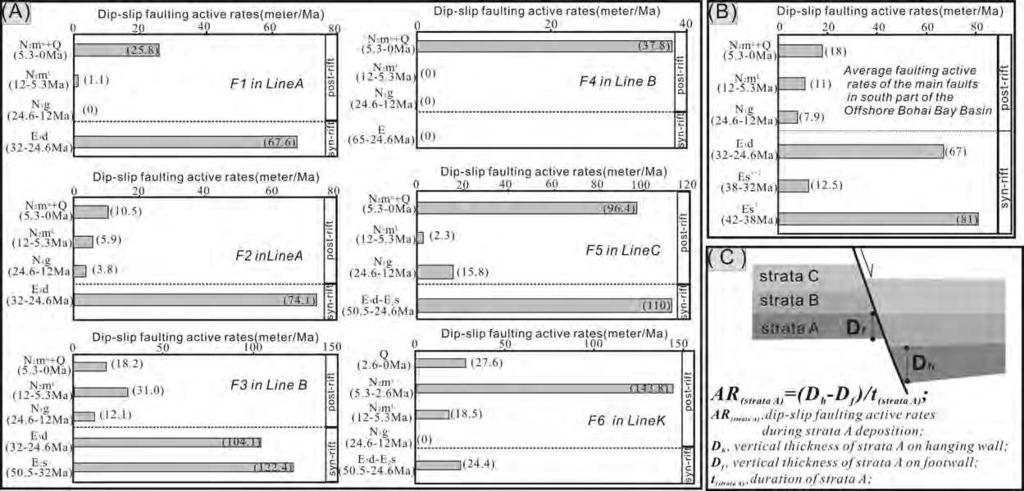
9 reveal differences in the style of Neogene-Quaternary faulting (Line D in Figure 5 versus Line F in Figure 8). The boundary between the middle and southern portions of the Bohai Bay Basin can also be identified from seismic data (Lines G and H in Figure 8). Based on the above-mentioned investigations of Neogene-Quaternary faulting, the following conclusions can be reached: (1) the Bohai Bay Basin can be divided into northern, middle and southern segments (Figure 1C); (2) a dense arrangement of Neogene-Quaternary faults developed in the middle segment, whereas sparse arrangement of Neogene-Quaternary faults developed in the northern and southern segments Evolutionary History In this study, reconstructed rates of active dip-slip faulting have been used to reveal the faults evolutionary history. This approach assumes that differences in the thickness of syn-kinematic strata between the hangingwall and footwall of individual fault planes are related to active periods of fault slip (cf. Maloney et al, 2012); thus, for any given stratal interval, the ratio of the thickness difference between the hangingwall and footwall and duration of the interval over which the body of strata accumulated can be used as an indicator of dip-slip faulting rate (for details of the method of calculation employed, see Fig. 9C). The assumption in this method requires that time-averaged sedimentation rate is equal to or greater than the rate of fault slip during synchronous periods of deposition and fault activity (Cartwright et al, 1998; Maloney et al, 2012). Sedimentation rates in the region where the investigated faults are located have been approximately determined from the ratio of the present stratal thickness and the relating sedimentary duration via seismic data. Results show that all the Neogene-Quaternary stratal intervals considered had sedimentation rates greater than rates of fault slip (>25 m/myr for N 1 g, >60 m/myr for N 2 m L, >100 m/myr for N 2 m U, and >150 m/myr for Q p ); the assumption made in the method is therefore reasonable for this study. Rates of active dip-slip fault displacement have been calculated for individual faults and 8
10 average rates have additionally been calculated for groups of main faults in the southern part of the Offshore Bohai Bay Basin (Figure 9A and B). Results for individual faults show that the larger faults that controlled the development of Paleogene half-grabens had higher active rates of dip-slip during the Paleogene, whereas, for the majority of faults that did not penetrate the entire Paleogene succession, the rate of active dip-slip during the lower Paleogene was less (Fig. 5, F4 in Line B). In the post-rift stage, the majority of faults have a greater rate of fault movement during N 2 m u -Q p deposition (5.3 Ma to the present day) compared to that experienced during N 2 m L -N 1 g deposition (24.6 Ma to 5.3 Ma), and many faults apparently were not active during N 1 g (24.6 Ma to 12 Ma) deposition (Figure 9A). Similar results relating to average active rates of fault movement also reveal more generally that the faults exhibited the highest rates of displacement during N 2 m u -Q p deposition (5.3Ma to the present day) for the whole post-rift stage (Figure 9B). Analysis of 3-D seismic data indicates that the Neogene-Quaternary faults in the middle segment of the basin were mainly developed after 5.3 Ma, which is supported by the following observations (Figure 10): (1) the number of faults present in the sequence that accumulated from 5.3 Ma to the present day is more than twice the number of faults present in the sequence that accumulated from 12 Ma to 5.3 Ma (Figure 10A); (2) the sequences that accumulated from 24.6 Ma to 5.3 Ma reveal no visible difference in thickness in the stratal packages present in the hangingwall and footwall of most Neogene-Quaternary faults, suggesting no syn-depositional fault activity for this period, despite many such faults having a throw of several hundreds of meters. This indicates that these faults were effectively inactive during this period (Figure 10B); (3) a large number of faults extend upward to the sea floor, demonstrating that they remain active to the present day. Given the above-mentioned frequent occurrence of historic and recent earthquakes in the Bohai Sea, this is to be expected. Indeed, the distribution of these earthquakes and focal-mechanism solutions demonstrate the close relationship between the Neogene-Quaternary faults and the strike-slip behavior of the Tan Lu and Zhangjiakou-Penglai fault zones (Chen and Nabelek,1988; Hsiao et al, 2004; Fu 9
11 244 et al, 2004; Zhu et al,2009) Origin and Controls The Neogene-Quaternary faults in the Bohai Bay Basin demonstrate that the NW-trending middle segment of the basin experienced intense faulting during the post-rift subsidence stage; this behavior is inconsistent with the style of evolution of typical rifted basins, which tend to be characterized by steady but generally weak faulting during the post-rift subsidence stage (Mckenzie, 1978; Ziegler and Cloetingh, 2004). Based on the geometrical characteristics and the distributions of the faults, it can be concluded that the faulting was closely associated with the NNE (or NE)-trending and NW-trending basement faults, and activity on these post-rift faults was mostly induced by the reactivation of these two major fault systems with a significant component of strike-slip movement during the Neogene and Quaternary. It is there therefore appropriate to refer to this phase of intense tectonic activity in the Bohai Bay Basin as Neogene-Quaternary tectonic reactivation. The occurrence in the basin of a NW-trending belt characterized by dense, shallow faults implies that the NW-trending Zhangjiakou-Penglai Fault Zone played the most significant role. Noticeably, the NNE-trending Tan-Lu Fault Zone runs through the eastern part of the basin rather than the middle segment of the basin; the intensive faulting along this fault zone also occurred in the northern and southern segments of the basin during Neogene-Quaternary, and this was characterized by a single dominant fault that extended upward to a shallow level and even to the sea floor apparently without association to a dense network of subsidiary normal faults (Figure 6, Line F in Figure 8). Thus, it is worth discussing the likely conditions required to cause such differences in the overall spatial pattern of distribution of Neogene-Quaternary faults. Analysis of the conditions required for the formation of Neogene-Quaternary faults demonstrates that both the density and pattern of these shallow faults were probably related to the thickness of Neogene-Quaternary strata. Considering this aspect, four types of behavior 10
12 are envisaged to account for the development of shallow faults in the Bohai Bay Basin (Figure 11): Type I: in areas characterized by a very thick accumulation of Neogene-Quaternary strata (equating to more than 2 seconds two-way travel time on the seismic profiles), such as the central portion of Bozhong sags and other deeper sags, the shallow faults are very densely packed, most were initiated during the Neogene-Quaternary, and a small number are not connect with the older faults either directly or indirectly (Figure 5: left part of Line A, right part of Line B and Line E). In this situation, one single old fault apparently induced the initiation and development of a wider network of Neogene-Quaternary faults. Type II: in areas characterized by a moderate thickness of accumulation of Neogene-Quaternary strata (equating to about 1 to 2 seconds two-way travel time on seismic profiles), shallow faults are arranged into a very dense pattern; most were initiated during the Neogene-Quaternary, and nearly all connect with the older faults either directly or indirectly. In this situation, one single old fault, either a sub-vertical strike-slip fault or a listric normal fault, apparently induced a narrower network of Neogene-Quaternary faults than in the first situation (compare the left part and right part of Line A in figure 5). Type III: in areas characterized by a very thin accumulation of Neogene-Quaternary strata (equating to less than 1 second two-way travel time on seismic profiles), such as the northern and southern segment of the basin, the shallow faults that elsewhere form dense networks are very sparse, and in places only the major Paleogene faults extend upward to the shallow level and even to the sea floor (Figure 8). Type IV: elsewhere in the areas characterized by a very thin accumulation of Neogene-Quaternary strata (equating to less than 1 second two-way travel time on seismic profiles), denser arrangements of shallow faults may occur. This type of situation only occurs in eastern part of the middle segment of the basin where the NW-trending Zhangjiakou-Penglai Fault Zone and NNE-trending Tan-Lu Fault Zone intersect (right parts of geological section XX in Figure 2 and seismic line A in Figure 5). 11
13 Based on the above discussion, the origin of the dense Neogene-Quaternary faults in the middle segment of the basin arose mainly in response to two conditions: (1) the interaction between the NW-trending and NNE(or NE)-trending faults, and (2) the occurrence of a thicker developed succession of Neogene-Quaternary strata. Both of these conditions favor the occurrence of a greater number of subsidiary faults at relatively shallow levels. The great majority of Neogene-Quaternary faults discussed above were induced by the reactivation of older faults; exceptions to this are a relatively small number of Neogene-Quaternary faults that were initiated by other conditions, including faults associated with igneous intrusions, as illustrated by seismic sections B and E (Figure 5) ACCELERATED TECTONIC SUBSIDENCE A second noteworthy characteristic of the Neogene-Quaternary evolution of the Bohai Bay Basin is a marked acceleration in the rate of tectonic subsidence that occurred at ~12 Ma. This event has been documented by the previous researchers (Hu et al, 2001; He and Wang, 2003; Xie et al, 2007) and has been interpreted as rapid tectonic subsidence that was considered to result from the dextral movement of the Tan-Lu Fault Zone. Further analysis and interpretation of this phenomenon is provided in this study. The back-stripping method (Steckler and Watts, 1978) is herein used to quantify the rate and history of tectonic subsidence in the main structural units (including rises and sags) of the Bohai Bay Basin for the Cenozoic and Quaternary. Data from 120 wells have been analyzed. A correction for compaction has been applied using porosity-depth relationships based on the observed lithologies, and by using standard mean exponential relationships, and material parameters (cf. Sclater and Christie, 1980). Input data include lithology, age and paleo-water depth. Lithologies and stratal ages have been obtained from well data; the biostratigraphy of Neogene-Quaternary strata have been studied in detail for the offshore the Bohai Sea (e.g. Deng and Li, 2008; Zhu et al, 2009), such that data pertaining to lithology and stratal ages for all investigated wells are credible. Paleo-water depths are inferred from depositional 12
14 environment; the water depths during Paleogene rifting stage are restricted to a narrow range of less than 50 m because most of the sediments were deposited in continental shallow lacustrine environments (Figure 3); by contrast, the water depths during Neogene-Quaternary post-rift stage are treated as zero because the great majority of the succession accumulated in a non-marine fluvial environment. The wells used in this study are distributed in a non-uniform arrangement across both the rises and sags, through more are located on the rises. Despite this, because the Neogene-Quaternary strata are relatively uniform and near-flat-lying with only gradual thickening to the basin center, it can be demonstrated that the Paleogene topography exerted only a modest influence on the thickness of accumulation of the succession; thus, the pattern and history of Neogene-Quaternary subsidence revealed by the studied well data reflects the overall trends for the entire basin. Given that some wells in the basin have been drilled on Neogene structural highs, care is required to ensure that these wells do not bias results due to the occurrence of locally anomalous data; considering this aspect, data from these wells have been ignored to eliminate this risk in this study. Given that the analysis of Paleogene subsidence is not the focus of this study, the data obtained solely from wells located in sags are considered sufficient for this analysis. Tectonic subsidence curves for the entire Cenozoic and Neogene-Quaternary post-rift stage are shown in Figure 12. The curves (Figure 12A) reveal an anomalous post-rift tectonic subsidence history that is characterized by a marked increase in subsidence rate. This differs significantly from the theoretical trend predicted by conventional post-rift subsidence models, which predict an exponentially decreasing rate of subsidence. This departure from the expected norm is demonstrated by comparison of subsidence curves from this study with theoretical post-rift tectonic subsidence curves arising from different stretching factors in a theoretical rift basin (cf. Baur et al, 2010) in Figure 12A. To more fully describe and analyze the change in tectonic subsidence a distinction is here made between rapid tectonic subsidence and accelerated tectonic subsidence. Rapid tectonic 13
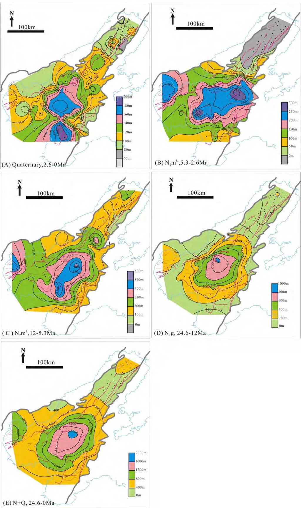
15 subsidence refers to a change in total tectonic subsidence in space, whereas accelerated tectonic subsidence emphasizes a change in tectonic subsidence rate over time; in this study, the former term is reflected by the total tectonic subsidence of several sedimentary intervals (Ng, N 2 m L, N 2 m U, Q) (Figure 13), whereas the latter term is reflected by the accelerated rate of tectonic subsidence relative to the N 1 g tectonic subsidence rate (accelerated intensity or AI for short, Figure 14); a steepening of the slope of the tectonic subsidence curve (distance/time) for a given point demonstrates accelerated subsidence (Figure 12B). For comparison, the contour maps in Figures 12 and 13 illustrate well the difference between the two terms: the area with greater total tectonic subsidence (i.e., rapid tectonic subsidence) may not necessarily experience an increase in the accelerated intensity of tectonic subsidence. The two terms have no strict inter-relationship or dependency (potential reasons for this are discussed below). From this study, the following interpretations are made regarding the Neogene-Quaternary tectonic subsidence of the Bohai Bay Basin: (1) Rapid tectonic subsidence occurred distinctly in the middle segment of the basin during the Neogene-Quaternary, and was characterized by increased total tectonic subsidence. It has a regular pattern such that the total tectonic subsidence is greatest in the Bozhong region (i.e., the Bozhong depression) during each sedimentary interval but gradually decreases with distance away from the center of this region. The Liaodongwan region, for example, experienced no deposition from Ma and consequently had a zero tectonic subsidence during this interval (Figure 13). (2) From the changes in the slope of the post-rift tectonic subsidence curve (Figure 12B), the following interpretations are made. The tectonic subsidence of the later post-rift subsidence stage (12-0 Ma) in the entire Bohai Bay Basin was clearly accelerated relative to that of the early post-rift subsidence stage ( Ma) and this change is here defined as an accelerated tectonic subsidence event. Indeed, three phases of accelerated tectonic subsidence are recognized: Ma, Ma and Ma. Most of the data reveal that the accelerated intensity of the three phases increased with time, with the exception of 14
16 data from the Liaodongwan region, which did not experience tectonic subsidence from Ma. This phenomenon identified here is inconsistent with the theoretical understanding regarding a purely thermal subsidence history during the post-rift thermal subsidence stage of rifted basin evolution, which is characterized by an exponential reduction in the rate of subsidence over time (Mckenzie, 1978). (3) Contour maps of the accelerated intensity (AI) based on analysis of well data reveal some detailed information about the nature of the accelerated tectonic subsidence (Figure 14): the entire configuration of the contours is similar with that of the contours of total tectonic subsidence in Figure 13, although it is important to note that the center of the Bozhong Depression, which has a greater total tectonic subsidence has a smaller accelerated intensity, whereas the area around the depression has a larger accelerated intensity. Also, the Liaodongwan region has a negative accelerated intensity during the period from Ma due to the zero tectonic subsidence. The overall distribution of the contours is not strictly controlled by the location of the NE-trending Tan-Lu Fault Zone and this indicates that the dextral movement of this fault zone exerted only a weak influence on the accelerated tectonic subsidence. (4) The rapid tectonic subsidence in the Bozhong region is characterized by a large total tectonic subsidence that was initiated during the N 1 g deposition following the rifting stage of the whole basin (Figure 13). This is consistent with the location of the depocenter and subsidence center of the whole Paleogene rifting basin; it may therefore reflect a natural evolutionary process of the rifted basin. By contrast, the onset of accelerated tectonic subsidence at 12Ma, which occurred in the whole basin and even in the entire East Asia continental margin (Hu et al., 2001; Ren et al, 2002; Yang et al, 2004; Xie et al, 2006), may reflect a change of regional geodynamic setting. Significantly, the occurrence of similar accelerated tectonic subsidence events in other rifted basins during their post-rift subsidence stages are usually considered to have arisen as an effect of intraplate stresses (e.g. Southern North Sea, Kooi et al.,1991; Black Sea Basin, Cloetingh et al., 2003). Thus, 15
17 it is conceivable, and arguably likely, that the post-rift subsidence of the Bohai Bay Basin was markedly influenced by intraplate stresses. (5) The final phase of accelerated tectonic subsidence (2.6 Ma to present) was most the intense and extensive (Figure 14B), implying that it arose in response to a dynamic setting that operated over a broad region. Noticeably, this phase of accelerated tectonic subsidence was more intense in some parts of the Liaodongwan region than in the other parts of the basin. By contrast, the Bozhong region, which experienced a greater total tectonic subsidence during the Quaternary and which is characterized by a relatively thick Neogene-Quaternary sedimentary succession, experienced weaker accelerated tectonic subsidence during this period (Figure14B) DISCUSSION Relationship between the Neogene-Quaternary Faults and Accelerated Tectonic Subsidence The enhancement of the syn-depositional normal faulting is the usual mechanism that results in accelerated tectonic subsidence; the rifting stage with intense faulting would be expected to result in a faster rate of tectonic subsidence than the post-rift stage. However, during the post-rift stage of the Bohai Bay Basin, the faulting also caused accelerated tectonic subsidence, as illustrated by the horizon-flatted seismic section in Figure 10B, for example, where the hangingwall reveals a thicker accumulated succession, thereby demonstrating syn-depositional fault activity (5.3-0 Ma). Thus, the accelerated intensity of the tectonic subsidence rate around the Bozhong Depression is greater than in the center of the depression; this may be due to the development of the network of dense faults around the depression (Figure 14). A significant question is to be resolved is whether all the accelerated subsidence of the Bohai Bay Basin occurred in response to the Neogene-Quaternary faulting. If this was the case then the accelerated subsidence would likely have occurred in the hangingwall only, 16
18 whereas the footwall and areas where no active faulting was present would not have been subjected to accelerated subsidence. Following this reasoning, we use the Neogene-Quaternary tectonic subsidence history from two wells (Well-1 and Well-2), located on the hangingwall and footwall of a master fault, to reveal the relationship between tectonic subsidence and faulting intensity (Figure 15). The following observations are made. (1) During the N 1 g deposition, the master fault ceased activity, whereas the footwall (Well-2) experienced more rapid tectonic subsidence than the hangingwall (Well-1); since that time, the master fault experienced intensive activity and tectonic subsidence in the hangingwall was substantially accelerated (especially during N 2 m u and Q); this demonstrates that the intense reactivity of the fault did indeed induce the accelerated subsidence. (2) for the same period, variation in the slopes of the two curves record that some accelerated subsidence occurred in both the hangingwall and the footwall; this trend implies that the accelerated subsidence is not entirely produced by the intense reactivity of the fault alone. Furthermore, comparison of the distributions of the densely spaced faults and the region that experienced an accelerated intensity of tectonic subsidence (Figure 6, 14) reveals that the two tectonic events did not wholly temporally nor spatially overlap and intense reactivation of the faults was not alone responsible for generating the entire component of accelerated subsidence; there must, therefore, be additional factors that contributed to the accelerated subsidence Geodynamics Previous studies show that the Bohai Sea is the location of the thinnest crust and lithosphere in northern China (Teng et al, 1997; Griffin et al 1998; Kusky et al, 2007; R.X. Zhu et al 2012). The broader region has been generally referred to as the site of craton destruction in the North China Craton, and is associated with widespread crustal extension and the formation of many rift basins (e.g. Wu et al., 2005; Zhai et al., 2007; Li et al, 2010; G. Zhu et al., 2012; R.X. Zhu et al., 2012; Figure.1A). Results from this study suggest that the 17
19 post-rift accelerated tectonic subsidence in the Bohai Bay Basin is most likely the manifestation of the reduced thickness of lithosphere, and is therefore a probable indicator of craton destruction in the North China Craton. Although the latest occurrence of craton destruction proposed previously has been early Cenozoic (Xu et al, 2009; R.X. Zhu et al., 2012), this post-rift accelerated tectonic subsidence may indicate a new phase of craton destruction in the North China Craton, with an onset age of 12 Ma. Furthermore, the widespread occurrence of a similar accelerated tectonic subsidence event, also with an onset age of 12 Ma, in the East Asia continental margin (Hu et al., 2001; Ren et al, 2002; Yang, et al, 2004; Xie, et al, 2006) indicates that the geodynamics of this tectonic event may be related to the subduction of the Pacific Plate relative to the Eurasian Plate. This conclusion is consistent with recent insights into dominant geodynamic controls on craton destruction of the North China Craton (R.X. Zhu et al., 2012). Recent GPS measurement and seismo-tectonic studies show that the eastward extrusion induced by India-Asia convergence is the dominant mode of block kinematics in north of China (Shen et al., 2000; Wang et al, 2001; Xie et al, 2004; Xu et al, 2008). It is therefore possible, and arguably probable, that India-Asia convergence is the driving force responsible for the widepsread development of the dense networks of shallow faults after 5.3 Ma. Specifically, the far-field effect of this convergence could be responsible for the lateral movements on the massifs around the Bohai Sea Basin, which induced the intense reactivation of the basement faults and produced the high density Neogene-Quaternary faults. This intense faulting would contribute to the accelerated tectonic subsidence. The post-rift accelerated tectonic subsidence in the Bohai Bay Basin may therefore have arisen as a result of deep geological function involving intraplate stresses, combined with rift-basin thermal subsidence Influence of Tectonic Reactivity on Hydrocarbon Accumulation The significance of the Neogene-Quaternary post-rift tectonic reactivation in terms of 18
20 petroleum geology is that it produced numerous structural traps as well as directly reforming the primary pressure and fluid fields of the basin; thus, it induced the redistribution and re-accumulation of hydrocarbons. The following discussion points arise: (1) The accelerated tectonic subsidence occurring after 12 Ma in the Bohai Bay Basin buried the Paleogene source rocks of the basin deeper, resulting in a higher maturity. This is especially the case for the Bozhong depression, offshore the Bohai Sea, site of the shallowest viable source rocks accumulated during Paleogene rifting stage (i.e., the source rock for the lower part of Dongying Formation). This additional subsidence enabled the source rocks to reach maturity due to the emplacement of additional overburden (Gong et al, 2010). Furthermore, as a direct result of accelerated tectonic subsidence, the offshore Bohai Sea deposited shallow, argillaceous lacustrine successions, and these likely served to enable the juxtaposition of seal and reservoir rocks required for the development of viable hydrocarbon plays (Deng and Li, 2008). (2) The networks of dense Neogene-Quaternary faults provided the most important pathway for vertical hydrocarbon migration from the Paleogene sequence to the Neogene sequence. Although some previous studies argue against the function of these shallow faults as conduits for the transport of hydrocarbons (e.g., Hao et al, 2007), statistical data analysed as part of this study relating to discovered reserves in the offshore Bohai Sea demonstrate that, in the middle segment (Bozhong region) of the Offshore Bohai Sea, 61% of the reserves are hosted in the Neogene sequence, suggesting that the existence of shallow faults connecting the Paleogene source rock with the Neogene reservoir rock has been critical for enabling hydrocarbon migration (Figure 16). By contrast, in the Liaodongwan region, where shallow faults are sparsely developed, shallow hydrocarbon reservoir are few in number. Thus, it is here suggested that these shallow faults played an active role in vertical hydrocarbon migration, and were the critical in enabling the charging of Neogene reservoirs in the Offshore Bohai Sea. Direct evidence to support this claim includes the occurrences of gas chimneys imaged on seismic data and gas vent 19
21 pits observed on the seafloor in the Offshore Bohai Sea, which indicates that faults that extend upward to the sea floor are highly efficient pathways for gas seepage to the sea floor (Deng and Li, 2008; Gong et al, 2010). Furthermore, fault patterns may also influence hydrocarbon accumulation (Figure 16): the Type II and Type IV fault patterns (described above) are most favorable for hydrocarbon accumulation at shallow levels since they are characterized by large numbers of Neogene subsidiary faults that connect to older faults either directly or indirectly. By contrast, the Type III fault pattern is least favorable due the presence of fewer Neogene subsidiary faults. Similarly, the Type I fault pattern in which Neogene subsidiary faults do not connect to older faults is also unfavorable for hydrocarbon accumulation at shallow levels. (3) Many Neogene structural traps were formed due to the influence of the post-rift tectonic reactivation in the Bohai Sea. Such traps are mostly associated with anticlines formed in response to regional compressional stress, many of which are affected by the normal faulting and strike-slip movement. Many of these structural traps have been discussed in the previous literature (e.g., Deng and Li, 2008; Zhu et al, 2009; Gong et al, 2010). (4) Theoretically, hydrocarbon accumulation is dominantly controlled by the latest tectonic event. Therefore, the Neogene-Quaternary tectonic reactivation in the Bohai Bay Basin was the critical tectonic event for hydrocarbon accumulation in the region. The peak accumulation of hydrocarbons in the offshore Bohai Sea occurred after 5.3 Ma (Gong et al, 2010), and undoubtedly this was a direct result of this tectonic event: the accelerated tectonic subsidence after 12 Ma enabled the generation of abundant hydrocarbons and the associated faulting facilitated their migration to shallow reservoirs. The intensity and long-lived duration of tectonic activity produced a large number of shallow structural closures, and also reformed the primary pressure and fluid fields required to drive migration and charge reservoirs. Pre-existing older reservoirs were also deformed as a consequence of this process, resulting in further hydrocarbon migration from the deeper 20
22 reservoirs through the networks of dense, shallow faults to further contribute to the re-charging of the new closures CONCLUSIONS The Bohai Bay Basin underwent intense post-rift tectonic reactivation, which was characterized by the development of a dense network of shallow faults and an anomalously high rate of post-rift tectonic subsidence. The following new insights regarding the structural deformation experienced in the Bohai Bay Basin during the Neogene-Quaternary have arisen as an outcome of this study: (1) The dense network of shallow faults is located solely in a NW-trending belt of the basin where the Zhangjiakou-Penglai Fault Zone was developed. Activity on most of these faults, which developed mainly after 5.3 Ma, was induced by the reactivation of NNE (or NE)-trending and NW-trending basement faults, which themselves experienced a substantial component of strike-slip movement during the Neogene and Quaternary. The origin and pattern of the dense network of faults arose in response to two conditions: interaction in the zone of intersection between the NW-trending and NNE (or NE)-trending faults, and the occurrence of a thick succession of Neogene and Quaternary strata. The accelerated rate of post-rift tectonic subsidence was distributed across the whole Bohai Bay Basin, and was initiated by 12 Ma; it evolved in three phases ( Ma, Ma and Ma) with each phase characterized by an increased rate of tectonic subsidence and a greater intensity of tectonic subsidence at the margin of the Bozhong Depression. (2) Fault reactivation acted as a contributory factor that further enhanced the rate of post-rift subsidence, especially around the Bozhong Depression. However, inconsistencies in the timing and spatial location of the faulting and accelerated subsidence demonstrates that the intense faulting was not the sole cause of the accelerated tectonic subsidence. The post-rift accelerated subsidence may indicate a new phase of craton destruction of the North China Craton, possibly related to the build-up of intraplate stresses at great depth combined with the 21
23 effects of rift-basin thermal subsidence. Results from this study imply a weak link between the anomalously high rate of tectonic subsidence and the dextral motion of the Tan-Lu Fault Zone, which is contrary to most previous suggestions. (3) This case study demonstrates that post-rift tectonic reactivation results in conditions that are favorable to hydrocarbon accumulation in a rift-basin setting. Post-rift tectonic reactivation in the Neogene-Quaternary resulted in the generation of a unique hydrocarbon habitat in the Bohai Bay Basin, whereby hydrocarbon formation, migration and accumulation within reservoirs occurred at a late and super-late stage, such that abundant shallow reservoirs exist in the NW-trending middle segment where the dense network of shallow faults that connect to the older faults (either directly or indirectly) are developed. (4) This study provides a detailed case study for an unusual style of post-rift tectonic reactivation within a rift-basin setting. It indicates that structural deformation associated with post-rift tectonic reactivation has a different expression to that which occurred during the syn-rift stage: it is less intense overall, yet arose in response to a complex and dynamic formative mechanism. This post-rift structural deformation may comprise two parts: one requires the reactivation of the syn-rift structural elements (i.e., fault development), whereas the other develops in a manner unrelated to syn-rift structural deformation (i.e., anomalous tectonic subsidence) ACKNOWLEDGEMENTS This study was funded by the Important National Science & Technology Specific Projects of China (Grant No. 2011ZX05023). We thank reviewers Julia F. Gale, Sandro Serra, Kevin T. Biddle, Steven G. Henry, along with anonymous reviewers, for their valuable reviews of earlier versions of this manuscript REFERENCES CITED Abadi, A. M., Van Wees, J. D., Van Dijk, P. M., Cloetingh, S. A. P. L., 2008, Tectonics and 22
24 subsidence evolution of the Sirt Basin, Libya: AAPG Bulletin, v.92, p Allen, M. B., MacDonald, D. I. M., Zhao, X., Vincent, S. J., Brouet-Menzies, C., 1998, Transtensional deformation in the evolution of the Bohai Basin, northern China, in R. E. Holdsworth, R. A. Strachan, and J. F. Dewey, eds., Continental transpressionand transtensional tectonics: Geological Society (London) Special Publication 135, p Allen, M. B., MacDonald, D. I. M., Zhao, X., Vincent, S. J., Brouet-Menzies, C., 1997, Early Cenozoic two-phase extension and late Cenozoic thermal subsidence and inversion of the Bohai Basin, northern China: Marine and Petroleum Geology, v.14, p Baur, F., Littke, R., Wielens, H., Lampe, C., Fuchs, T., 2010, Basin modeling meets rift analysis-a numerical modeling study from the Jeanne d'arc basin, offshore Newfoundland, Canada: Marine and Petroleum Geology, v.27, p Bosworth, W., Morley, C. K., 1994, Structural and stratigraphic evolution of the Anza rift, Kenya: Tectonophysics, v.236, p Bott, M. H. P., 1995, Rifted passive margins, in Olsen, K.H., eds., Continental Rifts: Evolution, Structure, Tectonics: Developments in Geotectonics 25, p Cartwright, J., Bouroullec, R., James, D., Johnson, H., 1998, Polycyclic motion history of some Gulf Coast growth faults from high-resolution displacement analysis: Geology, v.26, p Chen, W. P., Nabelek, J., 1988, Seismogenic strike-slip faulting and the development of the North China Basin: Tectonics, v.7, p Cloetingh, S., Spadini, G., van Wees, J. D., Beekman, F., 2003, Thermo-mechanical modelling of Black Sea Basin (de)formation: Sedimentary Geology, v.156, p Deng, Y. H., Li, J. P., 2008, Shallow reservoir formation mechanism-a case in the Bohai oil province: Beijing, Petroleum Industry Press, p Editorial Committee of Petroleum Geology of Dagang Oil Field, 1991, Petroleum geology of China (Vol 4): Dagang oil field: Beijing, Petroleum Industry Press, p
25 Fu, Z. X., Liu, J., Liu, G. P., 2004, On the long-term seismic hazard analysis in the Zhangjiakou Penglai seismotectonic zone, China: Tectonophysics, v.390, p Gong, Z. S., 2004a, Late-stage fault activities and oil and gas reservoir formation of China s offshore basins: China Petroleum Exploration, v.9, p Gong, Z. S., 2004b, Neotectonics and petroleum accumulation in Offshore Chinese Basins: Earth Science-Journal of China University of Geosciences, v.29, p Gong, Z. S., 2005, Cenozoic China offshore basins keeping active hydrocarbon accumulation to present: Acta Petrolei Sinica, v.26, p.1 6. Gong, Z. S., Cai, D. S., Zhang, G. C., 2007, Dominating action of Tan-lu Fault on hydrocarbon accumulation in eastern Bohai Sea area: Acta Petrolei Sinica, v.28, p Gong, Z. S., Wang, G. C., 2001, Neotectonism and late hydrocarbon accumulation in Bohai sea: Acta Petrolei Sinica, v.22, p.1 7. Gong, Z. S., Zhu, W. L., Chen, P. P. H., 2010, Revitalization of a mature oil-bearing basin by a paradigm shift in the exploration concept: A case history of Bohai Bay, Offshore China: Marine and Petroleum Geology, v.27, p Griffin, W. L., Zhang, A., O Reilly, S. Y., Ryan, C. G., 1998, Phanerozoic evolution of the lithosphere beneath the Sino-Korean craton, in Flower, M. F. J., Chung, S. L., Lo, C. H., Lee, T. Y., eds., Mantle Dynamics and Plate Interactions in East Asia: American Geophysical Union, Geodynamic Series 27, p Hao, F., Zou, H. Y, Gong, Z. S., Deng, Y. H., 2007, Petroleum migration and accumulation in the Bozhong sub-basin, Bohai Bay basin, China: significance of preferential petroleum migration pathways (PPMP) for the formation of large oilfields in lacustrine fault basins: Marine and Petroleum Geology, v.24, p He, L. J., Wang, J. Y., 2003, Cenozoic thermal history of the Bohai Bay Basin: constraintsfrom heat flow and coupled basin-mountain modeling: Physics and Chemistry of the Earth, v.28, p Hou, G. T., Qian, X. L., Song, X. M., 1998, The origin of the Bohai Bay Basin: Acta 24
26 Scicentiarum Naturalum Universitis Pekinesis, v.34, p Hsiao, L. Y., Graham, S. A., Tilander, N., 2004, Seismic reflection imaging of a major strike-slip fault zone in a rift system: Paleogene structure and evolution of the Tan-Lu fault system, Liaodong Bay, Bohai, offshore China: AAPG Bulletin, v.88, p Hu, S. B., O Sullivan, P. B., Raza, A., Kohn, B. P., 2001, Thermal history and tectonic subsidence of the Bohai Basin, northern China: a Cenozoic rifted and local pull-apart basin: Physics of the Earth and Planetary Interiors, v.126, p Huang, L., Liu, C. Y., Zhou, X. H., Wang, Y. B., 2012a, The important turning points during evolution of Cenozoic basin offshore the Bohai Sea: evidence and regional dynamics analysis: Science China Earth Sciences, v.55, p Huang, L., Wang. Y. B., Wu, Q., Wang, Q., 2012b, Cenozoic tectonic evolution of Laizhouwan sag in Bohai Basin: Acta Geologica Sinica, v.86, p Klimetz, M. P., 1983, Speculations on the Mesozoic plate tectonic evolution of eastern China: Tectonics, v.2, p Kooi, H., 1991, Tectonic modeling of extensional basins: the role of lithospheric flexure, intraplate stresses and relative sea-level change: PhD Thesis, Vrije Universiteit, Amsterdam, 183p. Kusky, T. M., Windley, B. F., Zhai, M.G.,2007, Tectonic evolution of the North China Block: from orogen to craton to orogen, in Zhai, M. G., Windley, B. F., Kusky, T. M., Meng, Q. R., eds., Mesozoic Sub-Continental Lithospheric Thinning Under Eastern Asia: Geological Society, London, Special Publications 280, p Li, D. S., 1980, Geological and structural characteristics of the petroliferous basins in the Bohai Bay: Acta Petrolei Sinica, v.1, p Li, M. G., Qi, J. F., Yang, Q., Xu, T. W., Chen, G., 2009, Cenozoic structure features of Huanghua Depression and its structure dynamics model: Acta Geoscientica Sinica, v.30, p Li, S. Z., Suo, Y. H., Dai, L. M., Liu, L. P., Jin, C., Liu, X., Hao, T. Y., Zhou, L. H., Liu, B. 25
27 H., Zhou, J. T., Jiao, Q., 2010, Development of the Bohai Bay Basin and destruction of the North China Craton: Earth Science Frontiers,v. 17,p Liang, S. J., 2001, The characteristics of tectonics and hydrocarbon accumulation of Jizhong Depression in late Cenozoic era: Master's thesis, Northwest University, Xi an, China, 110p. Liu, G. D.,1987, The Cenozoic rift system of the North China Plain and the deep internal process: Tectonophysics, v.133, p Maloney, D., Davies, R., Imber, J., King, S., 2012, Structure of the footwall of a listric fault system revealed by 3D seismic data from the Niger Delta: Basin Research, v.24, p Mckenzie, D. P., 1978, Some remarks on the development of sedimentary basins: Earth and Planetary Science Letters, v.40, p Ren, J. Y., Kensaku, T., Li, S. T., Zhang, J. X., 2002, Late Mesozoic and Cenozoic rifting and its dynamic setting in Eastern China and adjacent areas: Tectonophysics, v.344, p Ren, J. Y. Liao, Q. J., Lu, G. C. Fi, L. X. Zhou, J. Y. Qi, P., Shi, S. S., 2010, Deformation framework and evolution of the Huanghua Depression, Bohai Gulf: Geotectonicaet Metallogenia, v.34, p Sclater, J. G., Christie, P., 1980, Continental stretching: An explanation of the post-mid-cretaceous subsidence of the central North Sea Basin: Journal of Geophysical Research: Solid Earth, v.85(b7), p Shen, Z. K., Zhao, C., Yin, A., Li, Y., Jackson, D. D., Fang, P., Dong, D., 2000, Contemporary crustal deformation in east Asia constrained by Global Positioning System measurements: Journal of Geophysical Research: Solid Earth, v.105(b3), p Steckler, M. S., Watts, A. B., 1978, Subsidence of the Atlantic-type continental margin off New York: Earth and Planetary Science Letters, v.41, p
28 Teng, J. W. Zhang, Z. J. Zhang, B. M. Yang, D. H., Wan, Z. C. Zhang, H., 1997, Geophysical fields and background of exceptional structure for deep latent mantle plume in Bohai Sea: Chinese Journal of Geophysics, v.40,p Wang, Q., Zhang, P. Z., Freymueller, J. T., Bilham, R., Larson, K. M., Lai, X. A, You, X. Z., Niu, Z. J., Wu, J. C., Li, Y. X., Liu, J. N., Yang, Z. Q., Chen, Q. Z., 2001, Present-day crustal deformation in China constrained by global positioning system measurements: Science, v.294(5542), p Wu, F. Y., Lin, J. Q., Wilde, S. A., Zhang, X. O., Yang, J. H., 2005, Nature and significance of the Early Cretaceous giant igneous event in eastern China: Earth and Planetary Science Letters, v.233, p Xie, F. R., Cui, X. F., Zhao, J. T., Chen, Q. C., Li, H., 2004, Regional division of the recent tectonic stress field in China and adjacent areas: Chinese Journal of Geophysics, v.47, p Xie, X. N., Cui, T., Dietmar, M. R., Gong, Z. S., Guo, X. R., Liu, X. F., Zhang, C., 2007, Subsidence history and forming mechanism of anomalous tectonic subsidence in the Bozhong depression, Bohaiwan basin: Science China Earth Sciences, v.50, p Xie, X. N., Muller, R. D., Li, S. T., Gong, Z. S., Steinberger, B., 2006, Origin of anomalous subsidence along the Northern South China Sea margin and its relationship to dynamic topography: Marine and Petroleum Geology, v.23, p Xu, J., Ma, Z.J., Chen, G. G., Gong, Z. S., Deng, Q. D., Gao, X. L., Zhang, G. C., Cai, D. S., Zhang, J., Zhao, J. M., 2005, Estimating times of quaternary tectonic episodes in the Bohai Sea based on geomorphic features of surrounding mountainous areas: Quaternary Sciences, v.25, p Xu, J. R., Zhao, Z. X., Ishikawa, Y. Z., 2008, Regional characteristics of crustal stress field and tectonic motions in and around Chinese mainland: Chinese Journal of Geophysics, v.51, p Xu, Y. G., Li, H. Y., Pang, C. J., He, B., 2009, On the timing and duration of the destruction 27
29 of the North China Craton: Chinese Science Bulletin, v.54, p Yang, S. C., Hu, S. B., Cai, D. S., Feng, X. J., Chen, L. L., Gao, L., 2004, Present-day heat flow, thermal history and tectonic subsidence of the East China Sea Basin: Marine and Petroleum Geology, v.21, p Yang, Y. T., Xu, T. G., 2004, Hydrocarbon habitat of the offshore Bohai Basin, China: Marine and Petroleum Geology, v.21, p Ye, H., Shedlock, K. M., Hellinger, S. J., Sclater, J. G., 1985, The North China Basin: an example of a Cenozoic rifted intraplate basin: Tectonics, v.4, p Zhai, G. M., 1988, Petroleum geology of China (Vol 5): Northern China oil field: Beijing, Petroleum industry press, p Zhai, M. G., Fan, Q. C., Zhang, H. F., Sui, J. L., Shao, J. A., 2007, Lower crustal processes leading to Mesozoic lithospheric thinning beneath eastern North China: underplating, replacement and delamination: Lithos, v.96, p Zhu, G., Jiang, D. Z., Zhang, B. L., Chen, Y., 2012, Destruction of the eastern North China Craton in a backarc setting: Evidence from crustal deformation kinematics: Gondwana Research, v.22, p Zhu, R. X., Xu, Y. G., Zhu, G., Zhang, H. F., Xia, Q. K., Zheng, T. Y., 2012, Destruction of the North China Craton: Science China Earth Sciences, v.42, p Zhu, W. L., Mi, L. J., Gong, Z. S., et al, 2009, Hydrocarbon accummulation and exploration offshore the Bohai Sea: Beijing, Science Press p Ziegler, P. A., Cloetingh, S., 2004, Dynamic processes controlling evolution of rifted basins: Earth-Science Reviews, v.64, p VITAE OF AUTHORS Lei Huang ~ State Key Laboratory of Continental Dynamics, Northwest University, Taibai Road No.1, Xi an, Shaanxi , China; Tianjin Branch of CNOOC China Limited, Tianjin , China; yutian0620@163.com 28
30 Lei Huang is currently a Ph.D. student in the Geology Department of Northwest University and is also a geologist of the Tianjin branch of CNOOC Ltd. He received his B.Sc. and M.Sc. degrees from Northwest University. His research interests concern structural and tectonic analysis of sedimentary basins and petroleum geology. Chiyang Liu ~ State Key Laboratory of Continental Dynamics, Northwest University, Xi an, Shaanxi , China. Chiyang Liu is currently Professor of Geology at Northwest University. He received his B.Sc. and M.Sc. degrees from Northwest University. His academic research career spans almost 40 years in the fields of basin analysis and petroleum geology. Yingbin Wang ~ Tianjin Branch of CNOOC China Limited, Tianjin , China. Yingbin Wang received his B.Sc. degree from Northwest University. He is now the Chief Geologist of the Tianjin branch of CNOOC Ltd. His publications include studies of petroleum generation, migration, and accumulation in the offshore area of the Bohai Bay Basin. Junfeng Zhao ~ State Key Laboratory of Continental Dynamics, Northwest University, Xi an, Shaanxi ,China. Junfeng Zhao received his Ph.D. degree from Northwest University. He is now an Associate Professor of Geology at Northwest University. His current research intersts are in sedimentology and basin analysis. Nigel P. Mountney ~ School of Earth and Environment, University of Leeds, Leeds LS2 9JT, UK. Nigel P. Mountney obtained his B.Sc. from the University of Nottingham (1990), M.Sc. from Keele University (1992), and Ph.D. from the University of Birmingham (1996). He is currently Senior Lecturer in Sedimentology at the University of Leeds, where he is Founder and Director of the Fluvial & Eolian Research Group FIGURE CAPTIONS Figure 1. (A) Regional location and (B) simplified structure of the Cenozoic Bohai Bay Basin. (C) Location of seismic and well data used in this study. 29
31 Figure 2. Geological section through the Bohai Bay Basin. See Figure 1(C) for location Figure 3. General stratigraphy of the offshore Bohai Bay Basin showing major tectonic and depositional events. Lacustrine source rocks are concentrated in the Dongying and Shahejie formations. Form. = Formation; RPW depth = relative paleowater depth. This stratigraphy is representative of all wells analyzed in this study Figure 4. Epicenter distribution of earthquakes (Ms 5.0) in Bohai Bay Basin and adjacent areas for the period 1500 to 1999 (modified from Fu et al, 2004). The focal mechanism solutions are from Hsiao et al (2004) Figure 5. Non-interpreted and interpreted seismic sections through the middle of the Offshore Bohai Sea showing a network of denser faults developed in Neogene-Quaternary strata. Note the presence of an anticline below the Quaternary sequence in seismic line A, indicating an intensive regional compressive tectonic event occurring at about 2.6 Ma. See Figure 1(C) for location Figure 6. The planimetric distribution of the faults at the bottom of Pliocene sequence (A, about 5.3 Ma) and Oligocene sequence (B, about 38 Ma), offshore the Bohai Sea. Map C is the 3-D seismic coherency time slice (800ms) within the Neogene sequence of the area marked in Map A Figure 7. 3-D coherency seismic time slices (600 ms) within the Neogene sequence showing the distribution of Neogene faults in the Offshore Bohai Sea (A). (B)-(E) show details of some local areas that contrast the style of development of Paleogene and Neogene faults. Time slices from 1000 ms and 2500 ms from within the Paleogene sequence and basement are 30
32 presented. The en-echelon pattern of the subsidiary faults indicates the strike-slip movement of the basement faults during Neogene-Quaternary. See Figure 1(C) for location Figure 8. Non-interpreted and interpreted seismic sections showing different styles of development of Neogene faults. See Figure 1C for location. See the text for further explanation Figure 9. (A) Rates of active dip-slip faulting from some of the main faults indicated by black lines on the seismic sections shown in Figures 5 and 10; the number behind the gray columns are the rates of active dip-slip of the faults (m/myr); F1-F6 are marked on the seismic sections; note that for the analysis of F3, two parallel faults were treated as a whole. (B) Average rates of active dip-slip faulting of the main faults in the southern part of the Offshore Bohai Bay Basin. (C) Explanation of the methodology used for the calculation of the active rate of dip-slip faulting Figure 10. Seismic sections demonstrating that the Neogene-Quaternary faults were mainly developed after 5.3 Ma. (A) Two seismic sections show that most of the faults were developed in the N 2 m u and Q sequences (5.3-0 Ma). (B) Seismic Line B in Figure 5 without fault interpretation, and horizon-flatted sections from the base of the 5.3 Ma horizon and the 12 Ma horizon. Note the variety of the shaded areas between the hangingwall and footwall that show that notable differences in accumulated thicknesses caused by syn-depositional faulting between the hangingwall and footwall only occurred in the N 2 m u and Q sequences (5.3-0 Ma). See Figure 5 for fault interpretation of Line B. See Figure 1C for location Figure 11. Models describing the style of development of shallow faults in the Bohai Bay Basin. See the text for further explanation
33 Figure 12. Back-stripping analysis of tectonic subsidence (m) using data from wells in the Bohai Bay Basin during the whole Cenozoic (A, 65-0 Ma) and Neogene-Quaternary post-rift stage (B, Ma). The broad gray curves in (A) show the theoretical post-rift tectonic subsidence with different stretching factors for a standard rift basin (from a uniform Mckenzie model, modified from Baur et al, 2010). The curves reveal the marked anomalous post-rift tectonic subsidence history of the Bohai Bay Basin (characterized by increasing subsidence rate instead of the exponentially decreasing subsidence rate). See Figure 1C for well locations. All wells shown in Figure 1C are used in (B), whereas only those indicated as black dots in circle are used in (A) Figure 13 Contour maps of tectonic subsidence (m) of (A) Quaternary, Ma; (B) N 2 m u, Ma; (C) N 2 m L, Ma; (D) N 1 g, Ma; (E) Neogene and Quaternary, Ma. For comparison, the main faults at the bottom of the N 1 g (indicated as red lines) are superimposed; location of analyzed wells are indicated by black dots Figure 14. Contour maps of (A) tectonic subsidence rate (m/myr) during N 1 g deposition ( Ma), and the accelerated intensity of the tectonic subsidence rate relative to the N 1 g tectonic subsidence rate during (B) Quaternary, Ma; (C) N 2 m u, Ma; (D) N 2 m L, Ma. The numbers in maps B, C, D are the accelerated intensity of the tectonic subsidence rate relative to the early post-rift tectonic subsidence rate, and are obtained by the equation AI= (Ri-RN)/RN, where AI is the accelerated intensity, Ri and RN are the tectonic subsidence rates during the corresponding period (Quaternary, N 2 m u, N 2 m L ) and the episode of N 1 g deposition ( Ma), respectively; location of the analyzed well is indicated by the black dot Figure 15. (A) Seismic section across the boundary fault of a Paleogene half-graben (indicated as black line), which underwent intensive reactivation during the 32
34 Neogene Quaternary to produce many Neogene-Quaternary faults; (B) the active rate of tectonic subsidence (m/myr) of this master fault. (C) tectonic subsidence curves of two wells located on the hangingwall and footwall of this master fault, respectively. They indicate the relationship between fault reactivation and accelerated subsidence during the Neogene-Quaternary. See the text for further explanation Figure 16. Schematic-cross-section of Neogene reservoirs in the Offshore Bohai Sea showing the relationship between hydrocarbon accumulation and Neogene-Quaternary faulting. In the area with sparse Neogene-Quaternary faults, there are no Neogene reservoirs; by contrast, in the area characterized by a network of dense Neogene-Quaternary faults, many Neogene reservoirs are documented and these are usually closely related to old (Paleogene) faults that have been continuously active and their Neogene subsidiary faults, which connect to the Paleogene faults either directly or indirectly. Type II and IV fault patterns are most favorable for hydrocarbon accumulation at shallow levels, whereas the Type III fault pattern is least favorable; the Type I fault pattern, in which Neogene subsidiary faults do not connect to the older faults, is also unfavorable for hydrocarbon accumulation at shallow levels. 33

35

36
37

38

39

40

41

42

43
44

45

46

47
48

49

50

51
entered a rapid development phase. Annual increased proven reserves are above 500 billion cubic meters (bcm) from 2003, and annual natural gas product
 from 2003, and annual natural gas product") (), entered a rapid development phase. Annual increased proven reserves are above 500 billion cubic meters (bcm) from 2003, and annual natural gas production has increased from 50bcm in 2000 to nearly
(), entered a rapid development phase. Annual increased proven reserves are above 500 billion cubic meters (bcm) from 2003, and annual natural gas production has increased from 50bcm in 2000 to nearly
Structural Style and Tectonic Evolution of the Nakhon Basin, Gulf of Thailand
 Structural Style and Tectonic Evolution of the Nakhon Basin, Gulf of Thailand Piyaphong Chenrai Petroleum Geoscience Program, Department of Geology, Faculty of Science, Chulalongkorn University, Bangkok
EDIMENTARY BASINS. What is a Sedimentary Basin? by Prof. Dr. Abbas Mansour
 EDIMENTARY BASINS What is a Sedimentary Basin? by Prof. Dr. Abbas Mansour WHAT IS A SEDIMENTARY BASIN? A low area on the Earth s surface relative to surroundings e.g. deep ocean basin (5-10 km deep) e.g.
This is a repository copy of Defining a 3-dimensional trishear parameter space to understand the temporal evolution of fault propagation folds.
 This is a repository copy of Defining a 3-dimensional trishear parameter space to understand the temporal evolution of fault propagation folds. White Rose Research Online URL for this paper: http://eprints.whiterose.ac.uk/80599/
Seismic stratigraphy, some examples from Indian Ocean, interpretation of reflection data in interactive mode
 Seismic stratigraphy, some examples from Indian Ocean, interpretation of reflection data in interactive mode K. S. Krishna National Institute of Oceanography, Dona Paula, Goa-403 004. krishna@nio.org Seismic
Copyright McGraw-Hill Education. All rights reserved. No reproduction or distribution without the prior written consent of McGraw-Hill Education
 Copyright McGraw-Hill Education. All rights reserved. No reproduction or distribution without the prior written consent of McGraw-Hill Education Tibetan Plateau and Himalaya -southern Asia 11.00.a VE 10X
Bulletin of Earth Sciences of Thailand
 Quantitative Seismic Geomorphology of Early Miocene to Pleistocene Fluvial System of Northern Songkhla Basin, Gulf of Thailand Oanh Thi Tran Petroleum Geoscience Program, Department of Geology, Faculty
A comparison of structural styles and prospectivity along the Atlantic margin from Senegal to Benin. Peter Conn*, Ian Deighton* & Dario Chisari*
 A comparison of structural styles and prospectivity along the Atlantic margin from Senegal to Benin Overview Peter Conn*, Ian Deighton* & Dario Chisari* * TGS, Millbank House, Surbiton, UK, KT6 6AP The
Genetic models of structural traps related to normal faults in the Putaohua Oilfield, Songliao Basin
 302 DOI 10.1007/s12182-008-0050-0 Genetic models of structural traps related to normal faults in the Putaohua Oilfield, Songliao Basin Sun Simin 1, Wu Xinsong 1, Liu Hongtao 2 and Wang Changsheng 2 1 School
Sequence Stratigraphy. Historical Perspective
 Sequence Stratigraphy Historical Perspective Sequence Stratigraphy Sequence Stratigraphy is the subdivision of sedimentary basin fills into genetic packages bounded by unconformities and their correlative
Answers: Internal Processes and Structures (Isostasy)
") Answers: Internal Processes and Structures (Isostasy) 1. Analyse the adjustment of the crust to changes in loads associated with volcanism, mountain building, erosion, and glaciation by using the concept
Answers: Internal Processes and Structures (Isostasy) 1. Analyse the adjustment of the crust to changes in loads associated with volcanism, mountain building, erosion, and glaciation by using the concept
APPENDIX C GEOLOGICAL CHANCE OF SUCCESS RYDER SCOTT COMPANY PETROLEUM CONSULTANTS
 APPENDIX C GEOLOGICAL CHANCE OF SUCCESS Page 2 The Geological Chance of Success is intended to evaluate the probability that a functioning petroleum system is in place for each prospective reservoir. The
Fault growth & linkage
 Fault growth & linkage Important to understand fault growth, interaction & linkage Continental extension and basin formation Controls on subsurface fluid flow Hydrocarbon exploration & production Minerals
Structural Modelling of Inversion Structures: A case study on South Cambay Basin
 10 th Biennial International Conference & Exposition P 065 Structural Modelling of Inversion Structures: A case study on South Cambay Basin Dr. Mayadhar Sahoo & S.K Chakrabarti Summary The inversion in
Fault History analysis in Move
 Fault History analysis in Move The new Fault History plot in Move provides a method to conduct a quick-look analysis of the evolution of faults through time. By restoring the vertical displacement of a
Main controlling factors of hydrocarbon accumulation in Sujiatun oilfield of Lishu rift and its regularity in enrichment
 35 3 2016 9 GLOBAL GEOLOGY Vol. 35 No. 3 Sept. 2016 1004 5589 2016 03 0785 05 130062 P618. 130. 2 A doi 10. 3969 /j. issn. 1004-5589. 2016. 03. 019 Main controlling factors of hydrocarbon accumulation
Southern Songkhla Basin, Gulf of Thailand
 Architecture and Depositional Environment of Fluvial Systems of Southern Songkhla Basin, Gulf of Thailand Toan Manh Do Petroleum Geoscience Program, Department of Geology, Faculty of Science, Chulalongkorn
Bulletin of Earth Sciences of Thailand. Evaluation of the Petroleum Systems in the Lanta-Similan Area, Northern Pattani Basin, Gulf of Thailand
 Evaluation of the Petroleum Systems in the Lanta-Similan Area, Northern Pattani Basin, Gulf of Thailand Sirajum Munira Petroleum Geoscience Program, Department of Geology, Faculty of Science, Chulalongkorn
Stratigraphic Trap Identification Based on Restoration of Paleogeophology and Further Division of System Tract: A Case Study in Qingshui Subsag*
 Stratigraphic Trap Identification Based on Restoration of Paleogeophology and Further Division of System Tract: A Case Study in Qingshui Subsag* Cao Laisheng 1, Yu Lin 1, Liu Jianlun 1, Xiang Sheng 1,
Meandering Miocene Deep Sea Channel Systems Offshore Congo, West Africa
 Meandering Miocene Deep Sea Channel Systems Offshore Congo, West Africa S. Baer* (PGS), J. E. Comstock (PGS), K. Vrålstad (PGS), R. Borsato (PGS), M. Martin (PGS), J.P. Saba (SNPC), B. Débi-Obambé (SNPC)
Earth Science, (Tarbuck/Lutgens) Chapter 10: Mountain Building
 Chapter 10: Mountain Building") Earth Science, (Tarbuck/Lutgens) Chapter 10: Mountain Building 1) A(n) fault has little or no vertical movements of the two blocks. A) stick slip B) oblique slip C) strike slip D) dip slip 2) In a(n) fault,
Earth Science, (Tarbuck/Lutgens) Chapter 10: Mountain Building 1) A(n) fault has little or no vertical movements of the two blocks. A) stick slip B) oblique slip C) strike slip D) dip slip 2) In a(n) fault,
Neogene Uplift of The Barents Sea
 Neogene Uplift of The Barents Sea W. Fjeldskaar A. Amantov Tectonor/UiS, Stavanger, Norway FORCE seminar April 4, 2013 The project (2010-2012) Funding companies Flat Objective The objective of the work
Constrained Fault Construction
 Constrained Fault Construction Providing realistic interpretations of faults is critical in hydrocarbon and mineral exploration. Faults can act as conduits or barriers to subsurface fluid migration and
Structural Styles and Geotectonic Elements in Northwestern Mississippi: Interpreted from Gravity, Magnetic, and Proprietary 2D Seismic Data
 Structural Styles and Geotectonic Elements in Northwestern Mississippi: Interpreted from Gravity, Magnetic, and Proprietary 2D Seismic Data Nick Loundagin 1 and Gary L. Kinsland 2 1 6573 W. Euclid Pl.,
Late 20 th Century Tests of the Continental Drift Hypothesis
 Late 20 th Century Tests of the Continental Drift Hypothesis 5 Characteristics of the Ocean Trenches Unless otherwise noted the artwork and photographs in this slide show are original and by Burt Carter.
Classification of fault condensed belt and faults development characteristics in Xingbei Region, Daqing placanticline
 IOSR Journal of Engineering (IOSRJEN) ISSN (e): 2250-3021, ISSN (p): 2278-8719 Vol. 05, Issue 07 (July. 2015), V3 PP 29-33 www.iosrjen.org Classification of fault condensed belt and faults development
GLY 155 Introduction to Physical Geology, W. Altermann. Press & Siever, compressive forces. Compressive forces cause folding and faulting.
 Press & Siever, 1995 compressive forces Compressive forces cause folding and faulting. faults 1 Uplift is followed by erosion, which creates new horizontal surface. lava flows Volcanic eruptions cover
Earthquakes. Earthquakes are caused by a sudden release of energy
 Earthquakes Earthquakes are caused by a sudden release of energy The amount of energy released determines the magnitude of the earthquake Seismic waves carry the energy away from its origin Fig. 18.1 Origin
Plate Tectonics. entirely rock both and rock
 Plate Tectonics I. Tectonics A. Tectonic Forces are forces generated from within Earth causing rock to become. B. 1. The study of the origin and arrangement of Earth surface including mountain belts, continents,
Continental Margin Geology of Korea : Review and constraints on the opening of the East Sea (Japan Sea)
") Continental Margin Geology of Korea : Review and constraints on the opening of the East Sea (Japan Sea) Han-Joon Kim Marine Satellite & Observation Tech. Korea Ocean Research and Development Institute
Continental Margin Geology of Korea : Review and constraints on the opening of the East Sea (Japan Sea) Han-Joon Kim Marine Satellite & Observation Tech. Korea Ocean Research and Development Institute
Tomographic imaging of P wave velocity structure beneath the region around Beijing
 403 Doi: 10.1007/s11589-009-0403-9 Tomographic imaging of P wave velocity structure beneath the region around Beijing Zhifeng Ding Xiaofeng Zhou Yan Wu Guiyin Li and Hong Zhang Institute of Geophysics,
SEDIMENTARY BASINS Red Sea Coast of Egypt. by Prof. Dr. Abbas Mansour
 SEDIMENTARY BASINS Red Sea Coast of Egypt by Prof. Dr. Abbas Mansour Sedimentary basins Sedimentary basins are, in a very broad sense, all those areas in which sediments can accumulate to considerable
Geologic Structures. Changes in the shape and/or orientation of rocks in response to applied stress
 Geologic Structures Changes in the shape and/or orientation of rocks in response to applied stress Figure 15.19 Can be as big as a breadbox Or much bigger than a breadbox Three basic types Fractures >>>
Vail et al., 1977b. AAPG 1977 reprinted with permission of the AAPG whose permission is required for further use.
 Well 5 Well 4 Well 3 Well 2 Well 1 Vail et al., 1977b AAPG 1977 reprinted with permission of the AAPG whose permission is required for further use. Well 5 Well 4 Well 3 Well 2 Well 1 Vail et al., 1977b
The Impact of Paleogene-Neogene Tectonic Evolution on Oil-Gas Exploration: The Case of Eastern Liaoning Province
 The Impact of Paleogene-Neogene Tectonic Evolution on Oil-Gas Exploration: The Case of Eastern Liaoning Province Hao HUANG *,1, Tagen DAI 1, Anyu JING 2.1. School of Geology and lnfo-physics, Central South
Controls on clastic systems in the Angoche basin, Mozambique: tectonics, contourites and petroleum systems
 P2-2-13 Controls on clastic systems in the Angoche basin, Mozambique: tectonics, contourites and petroleum systems Eva Hollebeek, Olivia Osicki, Duplo Kornpihl Schlumberger, London, UK Introduction Offshore
Basin Analysis. Stra-graphy
 Basin Analysis Stra-graphy Basin Analysis Basin analysis integrates program sedimentological, stra-graphic, and tectonic principals to develop a full understanding of the rocks that fill sedimentary basins.
Orphan Basin, Offshore Newfoundland: New seismic data and hydrocarbon plays for a dormant Frontier Basin
 Orphan Basin, Offshore Newfoundland: New seismic data and hydrocarbon plays for a dormant Frontier Basin Jerry Smee* G&G Exploration Consulting, 301 400-3rd Avenue SW, Calgary, AB, T2P 4H2 Sam Nader, Paul
Interaction between Faults and Igneous Intrusions in Sedimentary Basins: Insights from 3D Seismic Reflection Data*
 Interaction between Faults and Igneous Intrusions in Sedimentary Basins: Insights from 3D Seismic Reflection Data* Craig Magee¹, Christopher A. Jackson¹, and Nick Schofield² Search and Discovery Article
GEO-DEEP9300 Lithosphere and Asthenosphere: Composition and Evolution
 GEO-DEEP9300 Lithosphere and Asthenosphere: Composition and Evolution Summary Presentation The Structural Evolution of the Deep Continental Lithosphere Focused on the Junction of Arabian, Eurasian and
6162 Upper Rhine Graben: 3D Seismic - A New Approach to Geothermal Exploration in a Structurally Complex Tectonic Enviroment
 6162 Upper Rhine Graben: 3D Seismic - A New Approach to Geothermal Exploration in a Structurally Complex Tectonic Enviroment C. G. Eichkitz* (Joanneum Research), M.G. Schreilechner (Joanneum Research),
Strike-Slip Faults. ! Fault motion is parallel to the strike of the fault.
 Strike-Slip Faults! Fault motion is parallel to the strike of the fault.! Usually vertical, no hanging-wall/footwall blocks.! Classified by the relative sense of motion. " Right lateral opposite block
 Sedimentary Basin Analysis http://eqsun.geo.arizona.edu/geo5xx/geos517/ Sedimentary basins can be classified based on the type of plate motions (divergent, convergent), type of the lithosphere, distance
SAND DISTRIBUTION AND RESERVOIR CHARACTERISTICS NORTH JAMJUREE FIELD, PATTANI BASIN, GULF OF THAILAND
 SAND DISTRIBUTION AND RESERVOIR CHARACTERISTICS NORTH JAMJUREE FIELD, PATTANI BASIN, GULF OF THAILAND Benjawan KIinkaew Petroleum Geoscience Program, Department of Geology, Faculty of Science, Chulalongkorn
Chapter 16. Mountain Building. Mountain Building. Mountains and Plate Tectonics. what s the connection?
 Chapter 16 Mountains and Plate Tectonics what s the connection? Mountain Building Most crustal deformation occurs along plate margins. S.2 Active Margin Passive Margin Mountain Building Factors Affecting
A) B) C) D) 4. Which diagram below best represents the pattern of magnetic orientation in the seafloor on the west (left) side of the ocean ridge?
 B) C) D) 4. Which diagram below best represents the pattern of magnetic orientation in the seafloor on the west (left) side of the ocean ridge?") 1. Crustal formation, which may cause the widening of an ocean, is most likely occurring at the boundary between the A) African Plate and the Eurasian Plate B) Pacific Plate and the Philippine Plate C)
1. Crustal formation, which may cause the widening of an ocean, is most likely occurring at the boundary between the A) African Plate and the Eurasian Plate B) Pacific Plate and the Philippine Plate C)
IV OTHER TYPES OF BASINS
 IV OTHER TYPES OF BASINS 1-Strike-slip basins 2-Cratonic basins 3 Late orogenic basins and more 1 Tectonic setting of strike-slip faulting Woodcock 1986 2 Seismic examples of stike-slip faults «!Flower
B.C. s Offshore Oil and Gas: a Guide to the Geology and Resources.
 B.C. s Offshore Oil and Gas: a Guide to the Geology and Resources. Introduction Beneath the offshore regions of British Columbia are four moderately large, geologically young sedimentary basins (Figure
Earth Systems Science Chapter 7. Earth Systems Science Chapter 7 11/11/2010. Seismology: study of earthquakes and related phenomena
 Earth Systems Science Chapter 7 I. Structure of the Earth II. Plate Tectonics The solid part of the earth system includes processes, just like the atmosphere and oceans. However, the time scales for processes
Improved Interpretability via Dual-sensor Towed Streamer 3D Seismic - A Case Study from East China Sea
 Improved Interpretability via Dual-sensor Towed Streamer 3D Seismic - A Case Study from East China Sea S. Rongfu (CNOOC Shanghai), C. Hua (CNOOC Shanghai), W. Yun (CNOOC Shanghai), Z. Yabin (CNOOC Shanghai),
FORCES ON EARTH. An investigation into how Newton s Laws of Motion are applied to the tectonic activity on Earth.
 FORCES ON EARTH An investigation into how Newton s Laws of Motion are applied to the tectonic activity on Earth. GEOLOGY Geologists scientists who study the forces that make and shape the Earth Geologists
USU 1360 TECTONICS / PROCESSES
 USU 1360 TECTONICS / PROCESSES Observe the world map and each enlargement Pacific Northwest Tibet South America Japan 03.00.a1 South Atlantic Arabian Peninsula Observe features near the Pacific Northwest
KEY CHAPTER 12 TAKE-HOME QUIZ INTERNAL STRUCTURES AND PROCESSES Score Part B = / 55 PART B
 GEOLOGY 12 KEY CHAPTER 12 TAKE-HOME QUIZ INTERNAL STRUCTURES AND PROCESSES Score Part B = / 55 PART B CHAPTER 12 Isostacy and Structural Geology 1. Using the terms below, label the following diagrams and
Kilometre-Scale Uplift of the Early Cretaceous Rift Section, Camamu Basin, Offshore North-East Brazil*
 Kilometre-Scale Uplift of the Early Cretaceous Rift Section, Camamu Basin, Offshore North-East Brazil* Iain Scotchman 1 and Dario Chiossi 2 Search and Discovery Article #50183 (2009) Posted May 20, 2009
The Ocean Floor Earth Science, 13e Chapter 13
 The Ocean Floor Earth Science, 13e Chapter 13 Stanley C. Hatfield Southwestern Illinois College The vast world ocean Earth is often referred to as the blue planet Seventy-one percent of Earth s surface
I. INTRODUCTION 1.1. Background and Problem Statement
 I. INTRODUCTION 1.1. Background and Problem Statement The declining of global oil and gas reserves has encouraged the exploration campaign to both the frontier area and the revisit to the mature basins.
Directed Reading. Section: How Mountains Form MOUNTAIN RANGES AND SYSTEMS. Skills Worksheet
 Skills Worksheet Directed Reading Section: How Mountains Form 1. How high is Mount Everest? a. about 1980 km above sea level b. more than 8 km below sea level c. more than 8 km above sea level d. more
11.1 Rock Deformation
 Tarbuck Lutgens Mountain Building 11.1 Rock Deformation Factors Affecting Deformation Factors that influence the strength of a rock and how it will deform include temperature, confining pressure, rock
Plate Tectonics: A Unifying Theory
 Plate Tectonics: A Unifying Theory What is Plate Tectonics? - 7 large tectonic plates and many smaller ones that break up the lithosphere - Plates are brittle and float on asthenosphere and glide past
MAR110 Lecture #5 Plate Tectonics-Earthquakes
 1 MAR110 Lecture #5 Plate Tectonics-Earthquakes Figure 5.0 Plate Formation & Subduction Destruction The formation of the ocean crust from magma that is upwelled into a pair of spreading centers. Pairs
Sedimentary Cycle Best Practice: Potential Eo-Oligocene Sediments in Western Indonesia*
 Sedimentary Cycle Best Practice: Potential Eo-Oligocene Sediments in Western Indonesia* Mellinda Arisandy 1 and I Wayan Darma 1 Search and Discovery Article #11008 (2017)** Posted November 6, 2017 *Adapted
Convergent plate boundaries. Objective to be able to explain the formation and key features of these zones.
 Convergent plate boundaries Objective to be able to explain the formation and key features of these zones. Destructive plate margins When plates collide due to convection currents/slab pull in the asthenosphere
Elliptical Fault Flow
 Elliptical Fault Flow Elliptical Fault Flow provides a new way to model and restore faults with variable offsets using Move. This new kinematic algorithm was created by Midland Valley, and is accessed
Comment on: Cenozoic evolution of the eastern Danish North Sea by M. Huuse, H. Lykke-Andersen and O. Michelsen, [Marine Geology 177, 243^269]
![Comment on: Cenozoic evolution of the eastern Danish North Sea by M. Huuse, H. Lykke-Andersen and O. Michelsen, [Marine Geology 177, 243^269]](/thumbs/93/112023617.jpg "Comment on: Cenozoic evolution of the eastern Danish North Sea by M. Huuse, H. Lykke-Andersen and O. Michelsen, [Marine Geology 177, 243^269]") Marine Geology 186 (2002) 571^575 Discussion Comment on: Cenozoic evolution of the eastern Danish North Sea by M. Huuse, H. Lykke-Andersen and O. Michelsen, [Marine Geology 177, 243^269] P. Japsen, T.
Marine Geology 186 (2002) 571^575 Discussion Comment on: Cenozoic evolution of the eastern Danish North Sea by M. Huuse, H. Lykke-Andersen and O. Michelsen, [Marine Geology 177, 243^269] P. Japsen, T.
Petroleum geology framework, West Coast offshore region
 Petroleum geology framework, West Coast offshore region James W. Haggart* Geological Survey of Canada, Vancouver, BC jhaggart@nrcan.gc.ca James R. Dietrich Geological Survey of Canada, Calgary, AB and
Maturity Modeling of Gomin and South Gomin fields Southern Pattani Basin, Gulf of Thailand
 Maturity Modeling of Gomin and South Gomin fields Southern Pattani Basin, Gulf of Thailand Patinya Jaithan Petroleum Geoscience Program, Department of Geology, Faculty of Science, Chulalongkorn University,
Migration Lag - What is it and how it affects Charge Risk and Fluid Properties*
 Migration Lag - What is it and how it affects Charge Risk and Fluid Properties* Zhiyong He 1 Search and Discovery Article #42014 (2017)** Posted February 20, 2017 *Adapted from oral presentation given
FORCES ON EARTH UNIT 3.2. An investigation into how Newton s Laws of Motion are applied to the tectonic activity on Earth.
 FORCES ON EARTH UNIT 3.2 An investigation into how Newton s Laws of Motion are applied to the tectonic activity on Earth. USE THESE NOTES: OUR HOME PLANET EARTH: What do you know about our planet? SO.HOW
Hydrocarbon Exploration of Mesozoic in Kutch Offshore Area
 6 th International Conference & Exposition on Petroleum Geophysics Kolkata 2006 Hydrocarbon Exploration of Mesozoic in Kutch Offshore Area Ram Krishna Singh 1, R.C. Agrawalla 2, D. P. Verma 3, A. K. Goel
Mountains and Mountain Building: Chapter 11
 Mountains and Mountain Building: Chapter 11 Objectives: 1)Explain how some of Earth s major mountain belts formed 2) Compare and contrast active and passive continental margins 3) Explain how compression,
TECTONIC AND STRUCTURAL CONTROLS ON INTRUSION- RELATED DEPOSITS IN THE NORTHERN PART OF SREDNA GORA ZONE, BULGARIA NIKOLAY PETROV & KAMELIA NEDKOVA
 TECTONIC AND STRUCTURAL CONTROLS ON INTRUSION- RELATED DEPOSITS IN THE NORTHERN PART OF SREDNA GORA ZONE, BULGARIA NIKOLAY PETROV & KAMELIA NEDKOVA INVESTIGATED AREA Praveshka Lakavica deposit Elatsite
Dynamic Subsidence and Uplift of the Colorado Plateau. Supplementary Material
 GSA DATA REPOSITORY 2010177 Liu and Gurnis Dynamic Subsidence and Uplift of the Colorado Plateau Supplementary Material Lijun Liu and Michael Gurnis Seismological Laboratory California Institute of Technology
Marine Science and Oceanography
 Marine Science and Oceanography Marine geology- study of the ocean floor Physical oceanography- study of waves, currents, and tides Marine biology study of nature and distribution of marine organisms Chemical
Evolution of Continents Chapter 20
 Evolution of Continents Chapter 20 Does not contain complete lecture notes. Mountain belts Orogenesis the processes that collectively produce a mountain belt Includes folding, thrust faulting, metamorphism,
Distribution of Overpressure and its Prediction in Saurashtra Dahanu Block, Western Offshore Basin, India*
 Distribution of Overpressure and its Prediction in Saurashtra Dahanu Block, Western Offshore Basin, India* Kanak R. Nambiar 1, B.K. Singh 2, R.N. Goswami 2, and K.R.K. Singh 2 Search and Discovery Article
Overview of the Seismic Source Characterization for the Palo Verde Nuclear Generating Station
 Overview of the Seismic Source Characterization for the Palo Verde Nuclear Generating Station Scott Lindvall SSC TI Team Lead Palo Verde SSC SSHAC Level 3 Project Tuesday, March 19, 2013 1 Questions from
This is a repository copy of Conceptualizing a circular framework of supply chain resource sustainability.
 This is a repository copy of Conceptualizing a circular framework of supply chain resource sustainability. White Rose Research Online URL for this paper: http://eprints.whiterose.ac.uk// Version: Accepted
Lateral extrusion and tectonic escape in Ilan Plain of northeastern Taiwan
 Lateral extrusion and tectonic escape in Ilan Plain of northeastern Taiwan Angelier, J., Chang, T.Y., Hu, J.C., Chang, C.P., Siame, L., Lee, J.C., Deffontaines, B., Chu, H.T, Lu, C.Y., Does extrusion occur
Earth s Continents and Seafloors. GEOL100 Physical Geology Ray Rector - Instructor
 Earth s Continents and Seafloors GEOL100 Physical Geology Ray Rector - Instructor OCEAN BASINS and CONTINENTAL PLATFORMS Key Concepts I. Earth s rocky surface covered by of two types of crust Dense, thin,
GEOLOGIC MAPS PART II
 EARTH AND ENVIRONMENT THROUGH TIME LABORATORY - EES 1005 LABORATORY FIVE GEOLOGIC MAPS PART II Introduction Geologic maps of orogenic belts are much more complex than maps of the stable interior. Just
24. Ocean Basins p
 24. Ocean Basins p. 350-372 Background The majority of the planet is covered by ocean- about %. So the majority of the Earth s crust is. This crust is hidden from view beneath the water so it is not as
Ministry of Oil and Minerals Petroleum Exploration & Production Authority BLOCK 80 (WADI SARR)
") Ministry of Oil and Minerals Petroleum Exploration & Production Authority BLOCK 80 (WADI SARR) The Wadi Sarr Block (80) occupies an area of 1961 km 2 on the Sayun- Masilah Basin in the central Yemen. Block
Ministry of Oil and Minerals Petroleum Exploration & Production Authority BLOCK 80 (WADI SARR) The Wadi Sarr Block (80) occupies an area of 1961 km 2 on the Sayun- Masilah Basin in the central Yemen. Block
Petroleum Potential of the Application Area L12-4
 Petroleum Potential of the Application Area L12-4 The Application Area (L12-4) is underlain by the western Officer Basin, beneath the Gunbarrel Basin. The general basin architecture is outlined in Figure
Serica Energy (UK) Limited. P.1840 Relinquishment Report. Blocks 210/19a & 210/20a. UK Northern North Sea
 Limited. P.1840 Relinquishment Report. Blocks 210/19a & 210/20a. UK Northern North Sea") Serica Energy (UK) Limited P.1840 Relinquishment Report Blocks 210/19a & 210/20a UK Northern North Sea January 2013 1 Header Licence: P.1840 Round: Licence Type: 26th Round Traditional "Drill-or-Drop"
Serica Energy (UK) Limited P.1840 Relinquishment Report Blocks 210/19a & 210/20a UK Northern North Sea January 2013 1 Header Licence: P.1840 Round: Licence Type: 26th Round Traditional "Drill-or-Drop"
Bulletin of Earth Sciences of Thailand. Controls on Reservoir Geometry and Distribution, Tantawan Field, Gulf of Thailand.
 Controls on Reservoir Geometry and Distribution, Tantawan Field, Gulf of Thailand Atchara Praidee Petroleum Geoscience Program, Department of Geology, Faculty of Science, Chulalongkorn University, Bangkok
3. PLATE TECTONICS LAST NAME (ALL IN CAPS): FIRST NAME: PLATES
: FIRST NAME: PLATES") LAST NAME (ALL IN CAPS): FIRST NAME: PLATES 3. PLATE TECTONICS The outer layers of the Earth are divided into the lithosphere and asthenosphere. The division is based on differences in mechanical properties
LAST NAME (ALL IN CAPS): FIRST NAME: PLATES 3. PLATE TECTONICS The outer layers of the Earth are divided into the lithosphere and asthenosphere. The division is based on differences in mechanical properties
1. Name at least one place that the mid-atlantic Ridge is exposed above sea level.
 Interpreting Tectonic and Bathymetric Maps. The purpose of this lab is to provide experience interpreting the bathymetry of the seafloor in terms of tectonic and geologic settings and processes. Use the
Figure 1: Location and bathymetry of the study area. Gulf of Guinea. Cameroon. Congo. Gabon. PGS/DGH Gabon MegaSurvey Coverage (35000Km 2 ) Eq.
 Eq.") Deepwater hydrocarbon prospectivity analysis of offshore North and South Gabon Muhammad S Tamannai (*), Thomas Hansen (1), Ron Borsato (1), Jennifer Greenhalgh (1) Martial-Rufin Moussavou (2) & Landry
Deepwater hydrocarbon prospectivity analysis of offshore North and South Gabon Muhammad S Tamannai (*), Thomas Hansen (1), Ron Borsato (1), Jennifer Greenhalgh (1) Martial-Rufin Moussavou (2) & Landry
EGAS. Ministry of Petroleum
 EGAS Ministry of Petroleum EGAS Ministry of Petroleum About The Block Location: N. Thekah offshore block is located at about 56 km to the north of the Mediterranean shore line, 85 km to the north west
Plate Tectonics - Demonstration
 Name: Reference: Prof. Larry Braile - Educational Resources Copyright 2000. L. Braile. Permission granted for reproduction for non-commercial uses. http://web.ics.purdue.edu/~braile/indexlinks/educ.htm
Section 7. Reading the Geologic History of Your Community. What Do You See? Think About It. Investigate. Learning Outcomes
 Chapter 3 Minerals, Rocks, and Structures Section 7 Reading the Geologic History of Your Community What Do You See? Learning Outcomes In this section, you will Goals Text Learning Outcomes In this section,
Geological Evolution of Bago-Yoma Basin, Onshore Myanmar*
 Geological Evolution of Bago-Yoma Basin, Onshore Myanmar* Seehapol Utitsan 1, Teekayu Benjawan 1, Suppakarn Thanatit 1, Wirote Wetmongkongorn 1, U. Soe Than 2, Khun Hline Myint 1, and Ler Bwe Wah 1 Search
Chapter Two. Figure 02_02. Geography of the Ocean Basins. The Sea Floor
 Chapter Two The Sea Floor Geography of the Ocean Basins Figure 02_02 The world ocean is the predominant feature on the Earth in total area. In the Northern Hemisphere, 61% of the total area is ocean. In
Chapter 10: Deformation and Mountain Building. Fig. 10.1
 Chapter 10: Deformation and Mountain Building Fig. 10.1 OBJECTIVES Describe the processes of rock deformation and compare and contrast ductile and brittle behavior in rocks. Explain how strike and dip
General Geologic Setting and Seismicity of the FHWA Project Site in the New Madrid Seismic Zone
 General Geologic Setting and Seismicity of the FHWA Project Site in the New Madrid Seismic Zone David Hoffman University of Missouri Rolla Natural Hazards Mitigation Institute Civil, Architectural & Environmental
Estimation of Pore Pressure from Well logs: A theoretical analysis and Case Study from an Offshore Basin, North Sea
 P-217 Estimation of Pore Pressure from Well logs: A theoretical analysis and Case Study from an Offshore Basin, North Sea Pritam Bera Final Year, M.Sc.Tech. (Applied Geophysics) Summary This paper concerns
Chapter 15 Structures
 Chapter 15 Structures Plummer/McGeary/Carlson (c) The McGraw-Hill Companies, Inc. TECTONIC FORCES AT WORK Stress & Strain Stress Strain Compressive stress Shortening strain Tensional stress stretching
GO ON. Directions: Use the diagram below to answer question 1.
 d i a g n o s t i c t e s t : e a r t h a n d s p a c e s c i e n c e question 1. 1. What is the correct order (starting from the surface) of Earth s layers? A crust, outer core, inner core, mantle B mantle,
Cenozoic Extensional Basin Development and Sedimentation in SW Montana
 Cenozoic Extensional Basin Development and Sedimentation in SW Montana Robert C. Thomas Department of Environmental Sciences, The University of Montana Western, Dillon, MT 59725, (406) 683-7615, r_thomas@umwestern.edu
Airborne gravity gradiometer surveying of petroleum systems under Lake Tanganyika, Tanzania
 Airborne gravity gradiometer surveying of petroleum systems under Lake Tanganyika, Tanzania D. Roberts Beach Energy P. Roy Chowdhury CGG S. J. Lowe CGG A. N. Christensen CGG Outline Introduction Geology