ABSTRACT VENEZUELA TRINIDAD CARIBBEAN OBLIQUE COLLISION MODEL REVISED. Roger Higgs, Geoclastica Ltd, UK
|
|
|
- Charlotte Benson
- 5 years ago
- Views:
Transcription
1 THE 4 TH GEOLOGICAL CONFERENCE OF THE GEOLOGICAL SOCIETY OF TRINIDAD AND TOBAGO June 17-22, 2007, Hilton Trinidad & Conference Centre Port-of-Spain, Trinidad and Tobago Caribbean Exploration Planning for the Future ABSTRACT VENEZUELA TRINIDAD CARIBBEAN OBLIQUE COLLISION MODEL REVISED Roger Higgs, Geoclastica Ltd, UK The popular tectonic model for Venezuela and Trinidad, whereby a Jurassic rift evolved into a Cretaceous-Tertiary passive margin, destroyed by E-younging (Paleocene- Miocene) collision with the relatively SE-migrating Caribbean Arc, has been tested rigorously by the author during 17 years of geological consulting studies in the region and an exhaustive literature review. The Caribbean Model requires three revisions, crucial for petroleum exploration: 1. Rifting continued much later, as indicated by an unseen "Carib Halite Formation" (c. 4 km; above Couva anhydrite), neither exposed (largely dissolved) nor drilled, of inferred Berriasian-Valanginian age (see companion abstract). In fact, rifting continued into Albian time, about 50 m.y. later than the generally accepted late Jurassic termination, as indicated by the syntectonic character of Lower Cretaceous strata (confined; sand rich; isolated carbonate highs; evaporites), e.g. Rio Negro; Barranquin; Laventille-Domoil
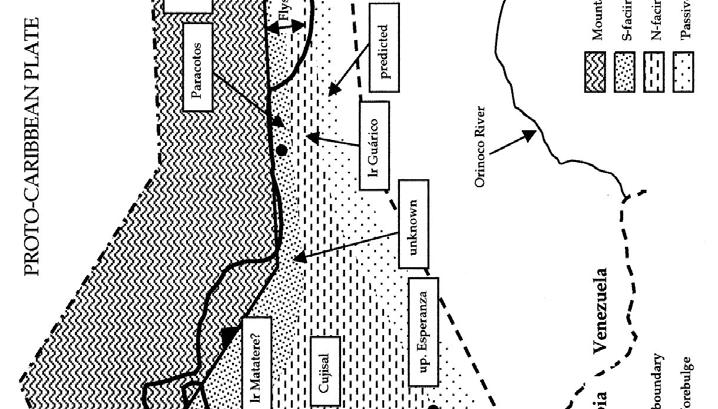
2 carbonate banks flanked by Toco-Lopinot-Cuche deep-water shale/turbidite/olistostrome basins (Fig. 1); 2. Orogenic onset was neither diachronous (Paleocene to Miocene), nor Caribbean, but began in latest Cretaceous (Campanian) time, synchronously along the entire Venezuela- Trinidad margin. The cause was slow (amagmatic) Proto-Caribbean subduction, driving southward the former outermost-margin (former) rift block and its passive-margin cover as a "Slope Nappe" (Fig. 1). This nappe overrode and metamorphosed rift and passive margin deposits (e.g. Caracas and Caribbean Groups), which in turn moved south (Miocene in Trinidad) in a "Shelf Nappe", whose frontal thrust lies just south of the Guaico and Couva wells, subcropping under the Gulf of Paria-Caroni supraorogen basin (Upper Miocene-Quaternary), except in eastern Caroni where the (Fishing Pond) thrust propagated to surface in the Quaternary (see below). The nappes produced a S-migrating thrust belt and Proto-Caribbean Foreland Basin (Figs 1, 2), comprising a flysch trough with an olistostromal-turbiditic northern slope and a muddy southern slope and outer shelf, resulting in a succession of paired formations (Campanian-Miocene in Trinidad, see fig. 1 of companion abstract): Galera wildflysch-guayaguayare shales; Chaudiere-lower Lizard Springs; Pierre-upper Lizard Springs; San Fernando (part)-navet; northern Cipero-lower Cipero; Nariva and Retrench-middle Cipero; lower Cunapo-upper Cipero; Brasso-upper Cipero; Herrera, Karamat, Lengua and Lower Cruse-unnamed in Columbus Basin. The advancing flysch trough arrived in Columbus Basin in Late Miocene time, becoming "overfillled" with Orinoco sediments; the thrust belt thus embraced all of Trinidad, Gulf of Paria and the eastern offshore, behind the South Coast Thrust. Starting in the Late 2
3 Miocene, despite continued Proto-Caribbean convergence, the thrust belt collapsed by buried-halite dissolution, forming a supraorogen basin throughout Trinidad and the Gulf of Paria (Manzanilla-Cruse through Talparo-Erin Fms, fringed by upper Cunapo; see companion abstract); and 3. The Caribbean Arc passed Guajira in Oligocene time (not Paleocene), arriving in Trinidad in the Pliocene (not Miocene). A forearc nappe was obducted diachronously onto the rear of the Slope Nappe, which was foundering by halite dissolution, producing a diachronous dissolution basin (Carupano-North Coast; Mio-Quaternary in the W, Plio- Quaternary in the E) atop the Caribbean basement and its forearc-basin cover (?Paleocene-Miocene). Caribbean collision took over as driver of subsidence in Columbus Basin, which thus evolved from a Proto- to a Caribbean Foreland Basin. Thrust-belt dissolution subsidence ended upon halite exhaustion, whereupon tectonic shortening reasserted itself, causing folding, thrusting and uplift of the dissolution-basin fill in early Quaternary time (southern 2/3 of Trinidad; post-talparo/erin). Around 1.5 Ma, Caribbean relative motion switched from SE to nearly E (085; GPS), due to the Panama Arc at the rear of the Caribbean Plate suturing against Colombia. In Trinidad the plate boundary jumped from the South Coast Thrust to the North Coast-El Pilar Fault Zone, whose 080 trend results in acute transpression, but uplift is outweighed by dissolution subsidence in the western N Range (companion abstract). South of the fault zone, the rest of Trinidad is isostatically rebounding, causing mud diapirism and dip-slip earthquakes (compressive-stress release). Rebound is outweighed 3
4 by dissolution subsidence in the Gulf of Paria, and by compaction- and shale-withdrawal subsidence in the Columbus Basin. These new concepts will affect exploration strategy, changing interpretations of subsidence and heat-flow (maturation) history, paleogeographic evolution, etc.. Many new plays will arise. For example, the Proto-Caribbean Foreland Basin model predicts dual sand fairways: northern turbiditic and southern shelf. Both fairways host large or giant oilfields in Trinidad and eastern Venezuela (e.g. Angostura, Brighton in the N; El Furrial in the S), serving as analogues for future exploration. The El Furrial play is predicted low in the S Trinidad thrust pile. 4


5 5 HIGGS


6 6 HIGGS
7 Figure 1. Schematic N-S paleo-section across northern South America continental margin at longitude of western Trinidad, at three different times, showing development of Slope Nappe and Shelf Nappe. Equally applicable to W, C and E Venezuela, except Shelf Nappe was uplifted earlier (Paleocene) in W and C Venezuela, as shown by forelandbasin clast compositions (Higgs, in review). For simplicity, this figure assumes faults cut entire crust, and neglects (a) halokinesis, (b) cannibalisation and nappe-overriding of early foreland-basin deposits, and (c) advance of thrust belt beyond nappe front. Figure 2. Late Maastrichtian tectonogeographic map of Venezuela and Trinidad, showing the proposed Proto-Caribbean Foreland Basin, comprising a northern flysch trough flanked, in the south, by a N-facing slope and shelf. Formation names shown in boxes. "Unknown" signifies that strata of this age, if deposited, are undiscovered or eroded or buried under younger deposits. "Predicted" means non-exposed, either buried in thrust sheets, or deeply buried under (or immediately ahead of) the present-day frontal thrust. Northern "Vidoño" is locally olistolithic (Higgs, in review). 7
OVERVIEW OF THE PETROLEUM GEOCHEMISTRY OF TRINIDAD AND TOBAGO by Krishna M. Persad
 OVERVIEW OF THE PETROLEUM GEOCHEMISTRY OF TRINIDAD AND TOBAGO by Krishna M. Persad CEO KPA Group of Companies AAPG YPs Lima Peru October 14th 2015 CONTENTS LOCATION PLATE TECTONICS SOURCE ROCKS OIL ALTERATIONS
Fluvial-Estuarine and Deltaic Reservoirs, Shelf Margin Delta and Slope Reservoir Characteristics Philip Sedore 2015
 Fluvial-Estuarine and Deltaic Reservoirs, Shelf Margin Delta and Slope Reservoir Characteristics Philip Sedore 2015 Introduction The offshore Columbus Basin and the onshore Southern Basin of Trinidad are
Earth Science, (Tarbuck/Lutgens) Chapter 10: Mountain Building
 Chapter 10: Mountain Building") Earth Science, (Tarbuck/Lutgens) Chapter 10: Mountain Building 1) A(n) fault has little or no vertical movements of the two blocks. A) stick slip B) oblique slip C) strike slip D) dip slip 2) In a(n) fault,
Earth Science, (Tarbuck/Lutgens) Chapter 10: Mountain Building 1) A(n) fault has little or no vertical movements of the two blocks. A) stick slip B) oblique slip C) strike slip D) dip slip 2) In a(n) fault,
Arc-Continent Collision: A Comparison of the SE Caribbean and Taiwan-Ryukyu Margins*
 Arc-Continent Collision: A Comparison of the SE Caribbean and Taiwan-Ryukyu Margins* Paddy Chesterman 1 Search and Discovery Article #30139 (2010) Posted November 30, 2010 *Adapted from oral presentation
Figure 1. Examples of vector displacement diagrams for two and three-plate systems.
 Figure 1. Examples of vector displacement diagrams for two and three-plate systems. Figure 2. Relationships between pole of rotation, great circles, ridge segments, small circles, transforms and fracture
caribbean basins, tectonics and hydrocarbons university of texas institute for geophysics
 Copyright by Trevor John Aitken 2005 CENOZOIC STRATIGRAPHIC AND TECTONIC HISTORY OF THE GRENADA AND TOBAGO BASINS AS DETERMINED FROM MARINE SEISMIC DATA, WELLS, AND ONLAND GEOLOGY by Trevor John Aitken,
Structure of the western Brooks Range fold and thrust belt, Arctic Alaska
 Trabajos de Geología, Universidad de Oviedo, 29 : 218-222 (2009) Structure of the western Brooks Range fold and thrust belt, Arctic Alaska J. DE VERA 1* AND K. MCCLAY 2 1Now at: Shell, Rijswijk, Netherlands.
SEDIMENTARY BASINS BASIN TYPES ACCORDING TO TECTONIC. by Prof. Dr. Abbas Mansour
 SEDIMENTARY BASINS BASIN TYPES ACCORDING TO TECTONIC by Prof. Dr. Abbas Mansour B. Convergent plate margins 10. STABLE CONTINENTAL INTERIOR BASIN E.g. Lake Eyre Basin Intracratonic (= within stable continental
The Building of the NYC Region
 The Building of the NYC Region Definitions Fall Line marks the area where an upland region (continental bedrock) and a coastal plain meet Piedmont the plateau region of the eastern United States which
Copyright McGraw-Hill Education. All rights reserved. No reproduction or distribution without the prior written consent of McGraw-Hill Education
 Copyright McGraw-Hill Education. All rights reserved. No reproduction or distribution without the prior written consent of McGraw-Hill Education Tibetan Plateau and Himalaya -southern Asia 11.00.a VE 10X
Structural Geology of the Mountains
 Structural Geology of the Mountains Clinton R. Tippett Shell Canada Limited, Calgary, Alberta clinton.tippett@shell.ca INTRODUCTION The Southern Rocky Mountains of Canada (Figure 1) are made up of several
The Late Tertiary Deep-Water Siliciclastic System of the Levant Margin - An Emerging Play Offshore Israel*
 The Late Tertiary Deep-Water Siliciclastic System of the Levant Margin - An Emerging Play Offshore Israel* Michael A. Gardosh 1, Yehezkel Druckman 2 and Binyamin Buchbinder 2 Search and Discovery Article
Structural Style and Tectonic Evolution of the Nakhon Basin, Gulf of Thailand
 Structural Style and Tectonic Evolution of the Nakhon Basin, Gulf of Thailand Piyaphong Chenrai Petroleum Geoscience Program, Department of Geology, Faculty of Science, Chulalongkorn University, Bangkok
A comparison of structural styles and prospectivity along the Atlantic margin from Senegal to Benin. Peter Conn*, Ian Deighton* & Dario Chisari*
 A comparison of structural styles and prospectivity along the Atlantic margin from Senegal to Benin Overview Peter Conn*, Ian Deighton* & Dario Chisari* * TGS, Millbank House, Surbiton, UK, KT6 6AP The
Kilometre-Scale Uplift of the Early Cretaceous Rift Section, Camamu Basin, Offshore North-East Brazil*
 Kilometre-Scale Uplift of the Early Cretaceous Rift Section, Camamu Basin, Offshore North-East Brazil* Iain Scotchman 1 and Dario Chiossi 2 Search and Discovery Article #50183 (2009) Posted May 20, 2009
Perspectives from Offshore Argentina & Uruguay
 Perspectives from Offshore Argentina & Uruguay A Prospectivity Overview Hannah Kearns October 2018 Introduction Argentina Offshore License Round 1 14 blocks Argentina North, 24 Austral-Malvinas Offshore
Marine Sedimentary Basins
 Marine Sedimentary Basins Paul Mann* Department of Earth and Atmospheric Sciences, 312 Science & Research 1, University of Houston, Houston, TX, USA Synonyms Active margin basins; Oceanic basins; Passive
Basin Analysis. Stra-graphy
 Basin Analysis Stra-graphy Basin Analysis Basin analysis integrates program sedimentological, stra-graphic, and tectonic principals to develop a full understanding of the rocks that fill sedimentary basins.
Meandering Miocene Deep Sea Channel Systems Offshore Congo, West Africa
 Meandering Miocene Deep Sea Channel Systems Offshore Congo, West Africa S. Baer* (PGS), J. E. Comstock (PGS), K. Vrålstad (PGS), R. Borsato (PGS), M. Martin (PGS), J.P. Saba (SNPC), B. Débi-Obambé (SNPC)
BALOCHISTAN FOLDBELT BASIN
 INTRODUCTION BALOCHISTAN FOLDBELT BASIN The Kharan-3 block is located in the Kharan Trough of Balochistan Basin. GEOLOGICAL SETTING The Balochistan Province is an Upper Cretaceous to Recent structurally
Structure of the Offshore Sinu Accretionary Wedge. Northern Colombia
 Structure of the Offshore Sinu Accretionary Wedge. Northern Colombia J. FLINCH, J. AMARAL*, A. DOULCET, B. MOULY, C. OSORIO* AND J. M. PINCE. Total CSTJF Pau, France, * TEPMA Colombia, Bogota. ABSTRACT
EGAS. Ministry of Petroleum
 EGAS Ministry of Petroleum EGAS Ministry of Petroleum About The Block Location: N. Thekah offshore block is located at about 56 km to the north of the Mediterranean shore line, 85 km to the north west
Geologic Trips San Francisco and the Bay Area
 Excerpt from Geologic Trips San Francisco and the Bay Area by Ted Konigsmark ISBN 0-9661316-4-9 GeoPress All rights reserved. No part of this book may be reproduced without written permission in writing,
Strike-Slip Faults. ! Fault motion is parallel to the strike of the fault.
 Strike-Slip Faults! Fault motion is parallel to the strike of the fault.! Usually vertical, no hanging-wall/footwall blocks.! Classified by the relative sense of motion. " Right lateral opposite block
EGAS. Ministry of Petroleum
 EGAS Ministry of Petroleum EGAS Ministry of Petroleum About The Block Location: N. El Arish offshore block is located in the extreme eastern part of the Egypt s economic water border and bounded from the
AGU 2014, San Francisco
 AGU 2014, San Francisco The applicability of detrital zircon in determining depositional ages and sedimentation rates in a retroarc foreland basin, Upper Cretaceous Magallanes-Austral basin, Patagonia
Structural Styles and Geotectonic Elements in Northwestern Mississippi: Interpreted from Gravity, Magnetic, and Proprietary 2D Seismic Data
 Structural Styles and Geotectonic Elements in Northwestern Mississippi: Interpreted from Gravity, Magnetic, and Proprietary 2D Seismic Data Nick Loundagin 1 and Gary L. Kinsland 2 1 6573 W. Euclid Pl.,
Geologic Structures. Changes in the shape and/or orientation of rocks in response to applied stress
 Geologic Structures Changes in the shape and/or orientation of rocks in response to applied stress Figure 15.19 Can be as big as a breadbox Or much bigger than a breadbox Three basic types Fractures >>>
The Sierra Leone-Liberia Emerging Deepwater Province*
 The Sierra Leone-Liberia Emerging Deepwater Province* Joan F. Flinch 1, José L. Huedo 1, Hernán Verzi 1, Héctor González 1, Ricardo Gerster 1, Abdul K. Mansaray 1, L. P. Painuly 1, Leticia Rodriguez-Blanco
NATURAL ENVIRONMENT. Geophysics
 NATURAL ENVIRONMENT Geophysics Geodynamics Alpine, Carpathian and Dinaric mountain belts surround the Pannonian (Carpathian) Basin, of Neogene through Quaternary in age. The Cenozoic evolution of the Alpine-Pannonian
TYPES OF SEDIMENTARY BASINS, MECHANISM OF BASIN FORMATION & PETROLEUM HABITAT BY S. K.BISWAS
 TYPES OF SEDIMENTARY BASINS, MECHANISM OF BASIN FORMATION & PETROLEUM HABITAT BY S. K.BISWAS BASIN DEFINITION, CHARACTERISTICS & CLASSIFICATION A sedimentary basin is a structurally morphotectonic depression
Hydrocarbon Charge Analysis of the SECC Block, Columbus Basin, Trinidad and Tobago
 Transactions of the 16 th Caribbean Geological Conference, Barbados. Caribbean Journal of Earth Science, 39 (2005), 21-27. Geological Society of Jamaica. Hydrocarbon Charge Analysis of the SECC Block,
South Pyrenean foreland basin
 South Pyrenean foreland basin 1 7 South Pyrenean foreland basin 1 8 South-Pyrenean Foreland basin S N Fore-bulge deformation Piggy-back B. Thrust nappes Basement Vergés & al, 2002 decollement Syntectonic
The Lithosphere and the Tectonic System. The Structure of the Earth. Temperature 3000º ºC. Mantle
 The Lithosphere and the Tectonic System Objectives: Understand the structure of the planet Earth Review the geologic timescale as a point of reference for the history of the Earth Examine the major relief
Blocks 31, 32, 33, 34, 35 & 36/03 Southeast Offshore Vietnam
 Blocks 31, 32, 33, 34, 35 & 36/03 Southeast Offshore Vietnam Block 31 32 33 34 35 36/03 Area (km 2) 5,036 4,440 4,630 4,700 4,630 2,950 Sea level (m) 20 20-30 30-40 50 50 50 Seismic 2D (km) 1,294 685 431
Deepwater Niger Delta fold-and-thrust belt modeled as a critical-taper wedge: The influence of a weak detachment on styles of fault-related folds
 Deepwater Niger Delta fold-and-thrust belt modeled as a critical-taper wedge: The influence of a weak detachment on styles of fault-related folds Frank Bilotti 1, Chris Guzofski 1, John H. Shaw 2 1 Chevron
Non-ideal Subduction
 Subduction zone cross sections Earthquake locations : black = teleseismic est. gray = local-array est. red line = top of slab seismicity blue line = center of slab seismicity Non-ideal Subduction Oblique
Plate Tectonics. Structure of the Earth
 Plate Tectonics Structure of the Earth The Earth can be considered as being made up of a series of concentric spheres, each made up of materials that differ in terms of composition and mechanical properties.
Salt tectonic styles in the spreading basin: Yucatan, Offshore Mexico Purnima Bhowmik*, Rodolfo Hernandez and Katarina Rothe, TGS
 1 Purnima Bhowmik*, Rodolfo Hernandez and Katarina Rothe, TGS Summary The TGS Gigante project is comprised of 188,497 km of 2D seismic data acquired in 2016 and primarily covering the offshore Mexican
Answers: Internal Processes and Structures (Isostasy)
") Answers: Internal Processes and Structures (Isostasy) 1. Analyse the adjustment of the crust to changes in loads associated with volcanism, mountain building, erosion, and glaciation by using the concept
Answers: Internal Processes and Structures (Isostasy) 1. Analyse the adjustment of the crust to changes in loads associated with volcanism, mountain building, erosion, and glaciation by using the concept
Orphan Basin, Offshore Newfoundland: New seismic data and hydrocarbon plays for a dormant Frontier Basin
 Orphan Basin, Offshore Newfoundland: New seismic data and hydrocarbon plays for a dormant Frontier Basin Jerry Smee* G&G Exploration Consulting, 301 400-3rd Avenue SW, Calgary, AB, T2P 4H2 Sam Nader, Paul
ANGOLA OFFSHORE LICENSING 2007 BLOCK 46
 AGOLA OFFHOR LICIG 2007 BLOCK 46 DATA BA AVAILABILITY Figure 1 shows the seismic data available on Block 46. Fig. 1 Commercial 2D surveys: esterngeco: 794 km. GX Technology: 116 km. Commercial 3D surveys:
3. SITE CHARACTERISATION AND FIELD OBSERVATIONS
 Page 13 3. SITE CHARACTERISATION AND FIELD OBSERVATIONS 3.1. Geology 3.1.1. Structural Geology Unlike most islands of the Lesser Antilles, Trinidad is of sedimentary origin, rather than volcanic composition.
Vail et al., 1977b. AAPG 1977 reprinted with permission of the AAPG whose permission is required for further use.
 Well 5 Well 4 Well 3 Well 2 Well 1 Vail et al., 1977b AAPG 1977 reprinted with permission of the AAPG whose permission is required for further use. Well 5 Well 4 Well 3 Well 2 Well 1 Vail et al., 1977b
KEY CHAPTER 12 TAKE-HOME QUIZ INTERNAL STRUCTURES AND PROCESSES Score Part B = / 55 PART B
 GEOLOGY 12 KEY CHAPTER 12 TAKE-HOME QUIZ INTERNAL STRUCTURES AND PROCESSES Score Part B = / 55 PART B CHAPTER 12 Isostacy and Structural Geology 1. Using the terms below, label the following diagrams and
Topics Laramide Orogeny: Late Cretaceous to Early Eocene Reading: GSA DNAG volume 3, Ch. 6
 Topics Laramide Orogeny: Late Cretaceous to Early Eocene Reading: GSA DNAG volume 3, Ch. 6 Late Cretaceous to early Eocene New patterns developed 5 main regions Tectonic interpretations Post-Laramide events
Evolution of Continents Chapter 20
 Evolution of Continents Chapter 20 Does not contain complete lecture notes. Mountain belts Orogenesis the processes that collectively produce a mountain belt Includes folding, thrust faulting, metamorphism,
Controls on clastic systems in the Angoche basin, Mozambique: tectonics, contourites and petroleum systems
 P2-2-13 Controls on clastic systems in the Angoche basin, Mozambique: tectonics, contourites and petroleum systems Eva Hollebeek, Olivia Osicki, Duplo Kornpihl Schlumberger, London, UK Introduction Offshore
Mountain Building. Mountain Building
 Mountain Building Mountain building has occurred during the recent geologic past American Cordillera the western margin of the Americas from Cape Horn to Alaska Includes the Andes and Rocky Mountains Alpine
USU 1360 TECTONICS / PROCESSES
 USU 1360 TECTONICS / PROCESSES Observe the world map and each enlargement Pacific Northwest Tibet South America Japan 03.00.a1 South Atlantic Arabian Peninsula Observe features near the Pacific Northwest
MUHAMMAD S TAMANNAI, DOUGLAS WINSTONE, IAN DEIGHTON & PETER CONN, TGS Nopec Geological Products and Services, London, United Kingdom
 Geological and Geophysical Evaluation of Offshore Morondava Frontier Basin based on Satellite Gravity, Well and regional 2D Seismic Data Interpretation MUHAMMAD S TAMANNAI, DOUGLAS WINSTONE, IAN DEIGHTON
The Mesozoic. Wednesday, November 30, 11
 The Mesozoic Periods of the Mesozoic Triassic- First period of the Mesozoic era Jurassic Cretaceous- Last period of the Mesozoic era Breakup of Pangaea Stage one (Triassic) Rifting and volcanism, normal
Chapter 16. Mountain Building. Mountain Building. Mountains and Plate Tectonics. what s the connection?
 Chapter 16 Mountains and Plate Tectonics what s the connection? Mountain Building Most crustal deformation occurs along plate margins. S.2 Active Margin Passive Margin Mountain Building Factors Affecting
Depositional Environments and Hydrocarbon Potential of Northern Ionian Sea
 Depositional Environments and Hydrocarbon Potential of Northern Ionian Sea Vasiliki Kosmidou George Makrodimitras Nick Papatheodorou Contents Area of Interest Studied Dataset Workflow SWIT and Paleolatitude
Mesozoic Earth History
 Mesozoic Earth History The Mesozoic Era 251-66 MYA Breakup of Pangea Changes in air and oceanic currents Evolution of new terrestrial and marine life Opening of the Atlantic Ocean Basin Rocky Mountains
Lecture 24: Convergent boundaries November 22, 2006
 Lecture 24: Convergent boundaries November 22, 2006 Convergent boundaries are characterized by consumption of oceaninc crust in subduction zones, with attendant arc volcanism, metamorphism and uplift.
Mountains are then built by deforming crust: Deformation & Mountain Building. Mountains form where stresses are high!
 Deformation & Mountain Building Where are mountains located? Deformation and Folding Mountain building Mountains form where stresses are high! Mountains form at all three types of plate boundaries where
Subsidence analysis of the Barinas-Apure Basin: Western Venezuela
 Subsidence analysis of the Barinas-Apure Basin: Western Venezuela Maria Jácoe* Sión Bolívar University, Caracas, Venezuela jacoe@usb.ve and L. Chacín Halliburton, El Rosal, Caracas, Venezuela Suary A series
Ministry of Oil and Minerals Petroleum Exploration & Production Authority BLOCK 80 (WADI SARR)
") Ministry of Oil and Minerals Petroleum Exploration & Production Authority BLOCK 80 (WADI SARR) The Wadi Sarr Block (80) occupies an area of 1961 km 2 on the Sayun- Masilah Basin in the central Yemen. Block
Ministry of Oil and Minerals Petroleum Exploration & Production Authority BLOCK 80 (WADI SARR) The Wadi Sarr Block (80) occupies an area of 1961 km 2 on the Sayun- Masilah Basin in the central Yemen. Block
Continental drift
 Plate Tectonics Continental drift Continental drift Continental drift Continental drift Continental drift Plate Tectonics Plate Tectonics Continental Drift and Paleomagnetism Paleomagnetism Renewed interest
Correlation of tectonic units from the Alps to Western Turkey
 Correlation of tectonic units from the Alps to Western Turkey Stefan M. Schmid (ETH Zürich) with Daniel Bernoulli, Bernhard Fügenschuh, Alexandre Kounov, Liviu Matenco, Roland Oberhänsli, Senecio Schefer,
Multiattributes and Seismic Interpretation of Offshore Exploratory Block in Bahrain A Case Study
 Multiattributes and Seismic Interpretation of Offshore Exploratory Block in Bahrain A Case Study Suresh Thampi, Aqeel Ahmed, Yahya Al-Ansari, Ali Shehab, Ahmed Fateh, Anindya Ghosh, Ghada Almoulani. The
Pre-Feasibility Report
 Pre-Feasibility Report Project Details: The Block MB-OSN-2005/1 is a Saurashtra shallow water block situated between GS-OSN- 2003/1(NELP-V) in the west, C-37/C-43 PEL in the east and Saurashtra - Dahanu
Overview of the Seismic Source Characterization for the Palo Verde Nuclear Generating Station
 Overview of the Seismic Source Characterization for the Palo Verde Nuclear Generating Station Scott Lindvall SSC TI Team Lead Palo Verde SSC SSHAC Level 3 Project Tuesday, March 19, 2013 1 Questions from
IRAQ. Target Exploration. Geodynamic Evolutions of The Sedimentary Basins of. This study is a major reference for Petroleum
 barr Target Exploration Target Exploration Geodynamic Evolutions of The Sedimentary Basins of IRAQ This study is a major reference for Petroleum Explorationists on the tectonics, stratigraphy, sedimentary
2.1. Central Indus Basin:
 14 2.1. Central Indus Basin: Research area lies in the Central Indus Basin of Pakistan. Central Indus Basin may be divided into following broad tectonic divisions from east to west (Kadri, 1995) (1) Punjab
Mesozoic Tectonics of the Blue Mountains Province
 Mesozoic Tectonics of the Blue Mountains Province Main Events Middle Triassic: normal subduction and facing arcs Late Triassic: arc-arc collision (?) Jurassic: long-lived terrane-continent collision (?)
Mountains and Mountain Building: Chapter 11
 Mountains and Mountain Building: Chapter 11 Objectives: 1)Explain how some of Earth s major mountain belts formed 2) Compare and contrast active and passive continental margins 3) Explain how compression,
Crags, Cracks, and Crumples: Crustal Deformation and Mountain Building
 Crags, Cracks, and Crumples: Crustal Deformation and Mountain Building Updated by: Rick Oches, Professor of Geology & Environmental Sciences Bentley University Waltham, Massachusetts Based on slides prepared
B.C. s Offshore Oil and Gas: a Guide to the Geology and Resources.
 B.C. s Offshore Oil and Gas: a Guide to the Geology and Resources. Introduction Beneath the offshore regions of British Columbia are four moderately large, geologically young sedimentary basins (Figure
Review participation point: The evidence for a fluid outer core is:
 DDA1 Continental Drift to Plate Tectonics PS 100 Chapter 28 Review participation point: The evidence for a fluid outer core is: A. Average density of the earth is greater than the density of the crust.
Rocks and the Rock Cycle. Banded Iron Formation
 Rocks and the Rock Cycle Banded Iron Formation Rocks Big rocks into pebbles, Pebbles into sand. I really hold a million, million Rocks here in my hand. Florence Parry Heide How do rocks change? How are
Essentials of Geology, 11e
 Essentials of Geology, 11e Crustal Deformation and Mountain Building Chapter 17 Instructor Jennifer Barson Spokane Falls Community College Geology 101 Stanley Hatfield Southwestern Illinois College Jennifer
Maturity Modeling of Gomin and South Gomin fields Southern Pattani Basin, Gulf of Thailand
 Maturity Modeling of Gomin and South Gomin fields Southern Pattani Basin, Gulf of Thailand Patinya Jaithan Petroleum Geoscience Program, Department of Geology, Faculty of Science, Chulalongkorn University,
 Sedimentary Basin Analysis http://eqsun.geo.arizona.edu/geo5xx/geos517/ Sedimentary basins can be classified based on the type of plate motions (divergent, convergent), type of the lithosphere, distance
Plate Tectonics. entirely rock both and rock
 Plate Tectonics I. Tectonics A. Tectonic Forces are forces generated from within Earth causing rock to become. B. 1. The study of the origin and arrangement of Earth surface including mountain belts, continents,
Global Tectonics. Kearey, Philip. Table of Contents ISBN-13: Historical perspective. 2. The interior of the Earth.
 Global Tectonics Kearey, Philip ISBN-13: 9781405107778 Table of Contents Preface. Acknowledgments. 1. Historical perspective. 1.1 Continental drift. 1.2 Sea floor spreading and the birth of plate tectonics.
11.1 Rock Deformation
 Tarbuck Lutgens Mountain Building 11.1 Rock Deformation Factors Affecting Deformation Factors that influence the strength of a rock and how it will deform include temperature, confining pressure, rock
Biostratigraphic and Lithostratigraphic Correlation of Sedimentary Strata in the Atlantic Coastal Plain
 Biostratigraphic and Lithostratigraphic Correlation of Sedimentary Strata in the Atlantic Coastal Plain Introduction to the Atlantic Coastal Plain (Please read this page prior to doing the lab) The Atlantic
A Tectonostratigraphic History of Orphan Basin, Offshore Newfoundland, Canada
 A Tectonostratigraphic History of Orphan Basin, Offshore Newfoundland, Canada Lynn T. Dafoe*, Charlotte E. Keen, Graham L. Williams, and Sonya A. Dehler, Geological Survey of Canada, Dartmouth, NS Canada
Tectonics and Hydrocarbon System, East Gobi Basin, Mongolia. Gary Prost, ConocoPhillips Canada, Calgary
 Tectonics and Hydrocarbon System, East Gobi Basin, Mongolia Gary Prost, ConocoPhillips Canada, Calgary Project Objectives (a joint project of Gulf Canada and ROC Oil) What structures can be expected in
Lecture Outlines PowerPoint. Chapter 10 Earth Science, 12e Tarbuck/Lutgens
 Lecture Outlines PowerPoint Chapter 10 Earth Science, 12e Tarbuck/Lutgens 2009 Pearson Prentice Hall This work is protected by United States copyright laws and is provided solely for the use of instructors
The Nature of Sedimentary Rocks
 The Nature of Sedimentary Rocks Sedimentary rocks are composed of: Fragments of other rocks Chemical precipitates Organic matter or biochemically produced materials The Nature of Sedimentary Rocks Sedimentary
Deepwater Hydrocarbon Potentialof Orange Basin, South Africa: An Untested Oil Play
 Deepwater Hydrocarbon Potentialof Orange Basin, South Africa: An Untested Oil Play Soumen Dasgupta*, Moumita Sengupta, Prem Kumar, Biswanath Ghosh, Dr. BNS Naidu anddr. Sudhir Mathur. Cairn India Limited,
IV OTHER TYPES OF BASINS
 IV OTHER TYPES OF BASINS 1-Strike-slip basins 2-Cratonic basins 3 Late orogenic basins and more 1 Tectonic setting of strike-slip faulting Woodcock 1986 2 Seismic examples of stike-slip faults «!Flower
Request For Bids Parcels
 Section 2 Page 14 This section provides a detailed description of each landsale parcel. Maps provided show the location of the land parcels and the released seismic data on those parcels. Hard copies and
Geology 300, Physical Geology Spring 2019 Quiz Ch 19, Plate Tectonics Name
 Geology 300, Physical Geology Spring 2019 Quiz Ch 19, Plate Tectonics Name MULTIPLE CHOICE. Choose the one alternative that best completes the statement or answers the question. 1) The portion of a fracture
Pore Pressure Predictions in the Challenging Supra / Sub-Salt Exploration Plays in Deep Water, Gulf of Mexico.
 AAPG, 2002, Annual convention, Extended abstract. SHAKER, SELIM*, Geopressure Analysis Services (G.A.S.), Houston TX SMITH, MICHAEL, Mineral Management Service, New Orleans, LA. Pore Pressure Predictions
Sequence stratigraphy and basin analysis of the Meso- to Cenozoic Tarfaya- Laayoune Basins, on- and offshore Morocco
 Sequence stratigraphy and basin analysis of the Meso- to Cenozoic Tarfaya- Laayoune Basins, on- and offshore Morocco INAUGURAL-DISSERTATION zur Erlangung der Doktorwtirde der Naturwissenschaftlich-Mathematischen
December 21, Chapter 11 mountain building E.notebook. Feb 19 8:19 AM. Feb 19 9:28 AM
 Mountains form along convergent plate boundaries. Typically (usually) if you look at a mountain range, you know that it is at a plate boundary (active continental margin) or has been some time in the past
Continental Landscapes
 Continental Landscapes Landscape influenced by tectonics, climate & differential weathering Most landforms developed within the last 2 million years System moves toward an equilibrium Continental Landscapes
Present Day and Paleo Hydrodynamics of the Marañon Basin, Peru
 Present Day and Paleo Hydrodynamics of the Marañon Basin, Impact on Oil Migration, Oil Quality and Trapping, Implications for Exploration and Production Summary Presentation January 2003 Acknowledgements
LAB 6: TRINIDAD BEACH FIELD TRIP
 OBJECTIVES: LAB 6: TRINIDAD BEACH FIELD TRIP 1) to develop your powers of observation, especially of geological phenomena; 2) to identify the rocks exposed at Trinidad Beach; 3) to reconstruct some of
Description of faults
 GLG310 Structural Geology Description of faults Horizontal stretch Crustal thickness Regional elevation Regional character Issues Normal Thrust/reverse Strike-slip >1 1 in one direction and < 1 in
Continental Margin Geology of Korea : Review and constraints on the opening of the East Sea (Japan Sea)
") Continental Margin Geology of Korea : Review and constraints on the opening of the East Sea (Japan Sea) Han-Joon Kim Marine Satellite & Observation Tech. Korea Ocean Research and Development Institute
Continental Margin Geology of Korea : Review and constraints on the opening of the East Sea (Japan Sea) Han-Joon Kim Marine Satellite & Observation Tech. Korea Ocean Research and Development Institute
THE NORTH SUMATERA BASIN : GEOLOGICAL FRAMEWORK & PETROLEUM SYSTEM REVIEW
 THE NORTH SUMATERA BASIN : GEOLOGICAL FRAMEWORK & PETROLEUM SYSTEM REVIEW By the Delegation of Indonesia : Bambang Wicaksono TM* Jonathan Setyoko H* Hermes Panggabean** * Lemigas ** PSG Krabi, 12-15 May
GEOLOGIC MAPS PART II
 EARTH AND ENVIRONMENT THROUGH TIME LABORATORY - EES 1005 LABORATORY FIVE GEOLOGIC MAPS PART II Introduction Geologic maps of orogenic belts are much more complex than maps of the stable interior. Just
Chapter 10: Deformation and Mountain Building. Fig. 10.1
 Chapter 10: Deformation and Mountain Building Fig. 10.1 OBJECTIVES Describe the processes of rock deformation and compare and contrast ductile and brittle behavior in rocks. Explain how strike and dip
Neogene Uplift of The Barents Sea
 Neogene Uplift of The Barents Sea W. Fjeldskaar A. Amantov Tectonor/UiS, Stavanger, Norway FORCE seminar April 4, 2013 The project (2010-2012) Funding companies Flat Objective The objective of the work
CARIBBEAN BASINS, TECTONICS AND HYDROCARBONS PHASE III
 CARIBBEAN BASINS, TECTONICS AND HYDROCARBONS PHASE III Appendix A Submitted by: Dr. Paul Mann, Professor Department of Earth and Atmospheric Sciences 312 Science and Research, Bldg. 1 University of Houston