EXTENSION, SEDIMENTATION AND MODIFICATION OF THE GREATER GULF OF MEXICO BASIN
|
|
|
- Whitney Newton
- 5 years ago
- Views:
Transcription
1 EXTENSION, SEDIMENTATION AND MODIFICATION OF THE GREATER GULF OF MEXICO BASIN --AND THE PLACE OF THE EAST TEXAS BASIN WITHIN IT Thomas E. Ewing, Frontera Exploration Consultants, San Antonio TX FOR ETGS TECH EXPO, March 2018
2 ABSTRACT The Northern Gulf of Mexico Basin is a complex set of Mesozoic-Cenozoic passive margin basins distinctive for the role of salt-related structuring. The basin formed by two phases of extension: Phase I (Norian-Callovian, Ma) extended continental crust over 200km in a NW-SE direction as North America 'pulled out' of Pangea; Phase II (Oxfordian-Valanginian) created new oceanic crust during a 42 o counterclockwise rotation of Yucatan. Phase I extension has formed the basic structural grain of the northern margins of the basin, including the East Texas - Sabine Uplift area. Northwest-oriented intracontinental transform zones form the northeastern margin of the basin complex, and separate zones within the basin. Stretching left blocks of thick crust surrounded by regions of thin, highly extended crust. The thick-crust blocks became the later 'arches' or 'uplifts' characteristic of the northeastern and western sectors of the Gulf of Mexico Basin, The intervening basins, along with the main Texas-Louisiana-Campeche Basin, probably sank below sea level, may have accumulated Jurassic presalt sediments, and then were covered with salt up to 2km thick during the initial contact of the basin with the world ocean. The East Texas salt basin is a linear NE-trending trough, which once contained thick salt that has now gone into pillows and diapirs. The geometry is quite different from North Louisiana; it may have formed in the lee of the Sabine block as it was pulled relative southeastward. Later modifications include thermal doming in the Cretaceous and Laramide-induced arching in the Eocene. The major Jurassic source rocks of the Gulf basins are at the base of the postrift subsidence, and are matured by further subsidence. Later Cretaceous source rocks (Eagle Ford) are mostly immature in East Texas but mature on the margins of the main Gulf of Mexico basin. The younger Cenozoic shelf-margin succession yields gas and some oil formed during outbuilding of the shelf margin by Cenozoic deltaic progradation.
3 WHAT IS THE GREATER GULF OF MEXICO (GGOM) BASIN? Location: Southern North America and southward to southern Mexico A complex of basins associated with opening of the Gulf of Mexico, Ma Interior basins are failed rifts and their postrift basins Much sedimentation due to filling of Gulf with sediment and subsequent loading In this talk: Northern GGOM only (N of Tampico) is considered.


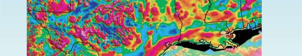
4 THE GULF OF MEXICO TODAY BATHYMETRY, CRUSTAL BLOCKS; MAYBE OIL AND GAS? Bathymetry and Topography


5 GULF OPENING IN WORLD CONTEXT Triassic 225 Ma Mid-Jurassic 165 Ma Mid-Cretaceous 100 Ma Courtesy of Ian Norton, UTIG / PLATES Project
6 TWO PHASES OF EXTENSION Phase I: ~60 m.y. (~ Ma, Nor-Clv) NW-SE extension; NW-trending linears Thick blocks and thinner extended areas of continental crust in NE Mexico and US Phase II: ~22 m.y. ( Ma, Oxf-Bar) Enhancement of west end of GOM spreading center leads to 42 o rotation of Yucatan Enhanced magma production due to back-arc position Contemporaneous with Border Rift (back-arc)
7 OPENING OF THE GULF OF MEXICO
8 PHASE I: NW-trending transfer zones separate rifts and blocks Pearl River (Florida of Klitgord) Tunica ( Cuban ) SW Sabine Generation of East Texas Trough and North Louisiana extension around Sabine block Freeport (Brazos of Hudec) Frio River zones Mexican linears: La Babia-Zapata, San Marcos-San Carlos, Parras-Galeana Most transfer zones are diffuse and complex
9 GGOM: 220 Ma (the Closed Configuration)


10 CRUST TYPES AND PHASE I LINEARS


11 NAMAG MAGNETIC MAP

12 PHASE 1 EXTENSION: East Texas, North Louisiana Sligo to Gilmer Isopach, from Cicero and Steinhoff (2013)


13 FT WORTH EAST TEXAS SECTION

14 PHASE I EXTENSION: South Texas

15 PHASE I EXTENSION: Linears in Mexico NW zones of translation in Jurassic, rejuvenated in Laramide Ewing, 2011

16 GGOM: 162 Ma (end of crustal extension)

17 EAST TEXAS, ABOUT 170 MA? 170 Ma - Jurassic, Texas Gulf Coast
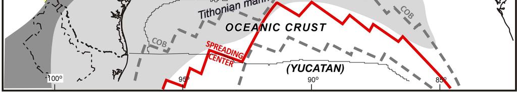
18 PHASE II: Rotation of Yucatan and seafloor spreading Ocean crust forms at seam generated by Phase I extension More magma produced in western Gulf than in eastern a back-arc effect More crust produced; allows/forces Yucatan to rotate counterclockwise 42 o Transition is same time as Nazas-Border Rift transition at Nazas (Lawton and Molina, 2014)


19 PHASE II EXTENSION: Rotational Spreading VGG Map, Sandwell et al. (2014)


20 PHASE II EXTENSION: Influence from a Mexican arc? Less magma 42 o of rotation Stern and Dickinson, 2010
21 GGOM: 140 Ma (end of ocean opening)


22 NORTHWESTERN GGOM SECTION: Llano Uplift To Perdido Foldbelt Peel et al., 1995, in Ewing 2016


23 NORTHERN GGOM SECTION: Toledo Bend To Sigsbee Escarpment Peel et al., 1995, in Ewing 2016
24 INFILLING SEDIMENTARY SEQUENCES Ewing and Galloway, in prep

 162 Ma")
 160 Ma")
 150 Ma")
 130 Ma")
 120 Ma")
 113 Ma")
")

25 TEXAS GEOHISTORY, MA 215 Ma Norian (Late Triassic) 162 Ma Callovian (Middle Jurassic) 160 Ma Oxfordian (Late Jurassic) 150 Ma Tithonian (Late Jurassic) 130 Ma Barremian (Early Cretaceous) 120 Ma Aptian (Early Cretaceous) 113 Ma Earliest Albian (Early Cretaceous) 105 Ma Albian (Early Cretaceous) 94 Ma Turonian (Late Cretaceous) Ewing, 2016


26 CRETACEOUS UPLIFTS and IGNEOUS FEATURES IN THE NORTHERN GULF


27 NORTHERN GULF GEOHISTORY, Ma Ewing and Galloway, in prep.


28 JUST ADD HYDROCARBONS
29 GULF COAST / GULF OF MEXICO LOCATION OF SOURCE ROCKS Jurassic source rocks (Smackover, Haynesville, Bossier) deposited at the beginning of the postrift subsidence They are matured by further subsidence. Postmature in large parts of main GOM Cretaceous source rocks (Eagle Ford) deposited late in the postrift subsidence Mature in the main GOM basin, immature on margins Lie near the bottom of the thick sedimentary package in main GOM. Cenozoic source rocks are mostly gas-generative formed during outbuilding of the shelf margin by Cenozoic deltaic progradation, assisted by regional transgressions No cap is present on the basin (except for subsalt plays), and seepage is widespread.

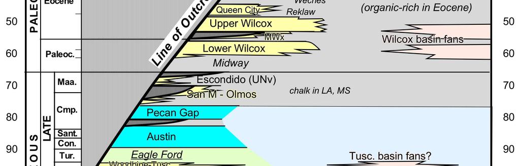


30 SOURCE ROCKS IN THE SEDIMENTARY FILL Ewing and Galloway, in prep
31 PETROLEUM SYSTEMS, NORTHERN GGOM 1) 2) 3) 4) Three main sources, two low in section (Jurassic, mid-cretaceous) Generation continuing at present Repetition of oil window by salt nappe(s) Strong vertical migration, no superseal; leaky basin

32 GULF OF MEXICO SOURCE ROCKS Hood et al., 2002


33 QUESTIONS?
34 REFERENCES Cicero, A.D., and Steinhoff, I., 2013, Sequence stratigraphy and depositional environments of the Haynesville and Bossier shales, east Texas and north Louisiana: in AAPG Memoir 105, p Ewing, T.E., 2011, Tectonic domains in the Rio Grande / Rio Bravo border region, Texas and Mexico: Laramide structures suggest earlier history: GCAGS Transactions v. 61, p Ewing, T.E., 2016, Texas Through Time: Lone Star geology, landscapes and resources. Austin, University of Texas Bureau of Economic Geology Udden Series 6, 431p. Ewing, T.E., and W.E. Galloway, in prep, Evolution of the Northern Gulf of Mexico sedimentary basin: in Basins of North America, 2 nd ed. (A. Miall, ed.). Elsevier Hood, K.C., L.M. Wenger, O.P. Gross and S.C. Harrison, 2002, Hydrocarbon systems analysis of the northern Gulf of Mexico: delineation of hydrocarbon migration pathways using seeps and seismic imaging: in AAPG Studies in Geology 48, p Lawton and Molina, 2014 Peel, F.J., C.J Travis and J.R. Hossack, 1995, Genetic structural provinces and salt tectonics of the Cenozoic offshore U.S. Gulf of Mexico: in AAPG Memoir 65, p Sandwell, D.T., Müller, R.D., Smith, W.H.F., Garcia, E., and Francis, R., 2014, New global marine gravity model from CryoSat-2 and Jason-1 reveals buried tectonic structure: Science, v.346, p Sawyer, D.S., R.T. Buffler, and R.H. Pilger, Jr., 1991, The crust under the Gulf of Mexico basin; in The Gulf of Mexico Basin. Boulder, Geological Society of America, Geology of North America, v.j, p Stern, R.J., and Dickinson, W.R., 2010, The Gulf of Mexico is a Jurassic backarc basin: Geosphere, v.6, p
Salt tectonic styles in the spreading basin: Yucatan, Offshore Mexico Purnima Bhowmik*, Rodolfo Hernandez and Katarina Rothe, TGS
 1 Purnima Bhowmik*, Rodolfo Hernandez and Katarina Rothe, TGS Summary The TGS Gigante project is comprised of 188,497 km of 2D seismic data acquired in 2016 and primarily covering the offshore Mexican
Figure 1. Examples of vector displacement diagrams for two and three-plate systems.
 Figure 1. Examples of vector displacement diagrams for two and three-plate systems. Figure 2. Relationships between pole of rotation, great circles, ridge segments, small circles, transforms and fracture
FY 2008 Annual Technical Report for NCRDS State Cooperative Program
 FY 2008 Annual Technical Report for NCRDS State Cooperative Program SUBSURFACE JURASSIC AND CRETACEOUS GAS-SHALE SAMPLES, HAYNESVILLE AND BOSSIER FORMATIONS (SABINE UPLIFT), AND EAGLEFORD GROUP (RIO GRANDE
Thesis Proposal: Salt Reconstruction and Study of Depositional History, Upper Jurassic, East Texas Basin
 Thesis Proposal: Salt Reconstruction and Study of Depositional History, Upper Jurassic, East Texas Basin By: Krista Mondelli Advisor: Dr. Chris Liner April, 2009 2 Introduction The East Texas Basin covers
35th Annual GCSSEPM Foundation Bob F Perkins Research Conference 2016
 35th Annual GCSSEPM Foundation Bob F Perkins Research Conference 2016 Mesozoic of the Gulf Rim and Beyond: New Progress in Science and Exploration of the Gulf of Mexico Basin Houston, Texas, USA 8 9 December
A comparison of structural styles and prospectivity along the Atlantic margin from Senegal to Benin. Peter Conn*, Ian Deighton* & Dario Chisari*
 A comparison of structural styles and prospectivity along the Atlantic margin from Senegal to Benin Overview Peter Conn*, Ian Deighton* & Dario Chisari* * TGS, Millbank House, Surbiton, UK, KT6 6AP The
Search and Discovery Article #50379 (2011) Posted February 25, Abstract
 Posted February 25, Abstract") Click to view oral presentation, with abstract and references. Understanding the Regional Haynesville and Bossier Shale Depositional Systems in East Texas and Northern Louisiana: An Integrated Structural/Stratigraphic
Click to view oral presentation, with abstract and references. Understanding the Regional Haynesville and Bossier Shale Depositional Systems in East Texas and Northern Louisiana: An Integrated Structural/Stratigraphic
Kilometre-Scale Uplift of the Early Cretaceous Rift Section, Camamu Basin, Offshore North-East Brazil*
 Kilometre-Scale Uplift of the Early Cretaceous Rift Section, Camamu Basin, Offshore North-East Brazil* Iain Scotchman 1 and Dario Chiossi 2 Search and Discovery Article #50183 (2009) Posted May 20, 2009
It has recently been demonstrated (Jacques and Clegg, 2002;
 Digital integration of potential fields and geologic data sets for plate tectonic and basin dynamic modeling the first step toward identifying new play concepts in the Gulf of Mexico Basin JOHN M. JACQUES,
Controls on clastic systems in the Angoche basin, Mozambique: tectonics, contourites and petroleum systems
 P2-2-13 Controls on clastic systems in the Angoche basin, Mozambique: tectonics, contourites and petroleum systems Eva Hollebeek, Olivia Osicki, Duplo Kornpihl Schlumberger, London, UK Introduction Offshore
Meandering Miocene Deep Sea Channel Systems Offshore Congo, West Africa
 Meandering Miocene Deep Sea Channel Systems Offshore Congo, West Africa S. Baer* (PGS), J. E. Comstock (PGS), K. Vrålstad (PGS), R. Borsato (PGS), M. Martin (PGS), J.P. Saba (SNPC), B. Débi-Obambé (SNPC)
Integrated Geophysics Corporation
 Structural Framework Burgos Basin ASSESSING THE POTENTIAL OF THE BURGOS BASIN Structural framework of the Super Burgos Basin Correlation to production trends: Tertiary Plays: Frio, Vicksburg & Wilcox Cretaceous
Orphan Basin, Offshore Newfoundland: New seismic data and hydrocarbon plays for a dormant Frontier Basin
 Orphan Basin, Offshore Newfoundland: New seismic data and hydrocarbon plays for a dormant Frontier Basin Jerry Smee* G&G Exploration Consulting, 301 400-3rd Avenue SW, Calgary, AB, T2P 4H2 Sam Nader, Paul
Osareni C. Ogiesoba and Angela K. Eluwa. Bureau of Economic Geology, University of Texas at Austin, Burnet Rd., Austin Texas 78759
 Structural Styles of Eocene Jackson and Oligocene Vicksburg Formations within the Rio Grande and Houston Embayments near the San Marcos Arch, Refugio and Calhoun Counties, South Texas Gulf Coast Osareni
A Tectonostratigraphic History of Orphan Basin, Offshore Newfoundland, Canada
 A Tectonostratigraphic History of Orphan Basin, Offshore Newfoundland, Canada Lynn T. Dafoe*, Charlotte E. Keen, Graham L. Williams, and Sonya A. Dehler, Geological Survey of Canada, Dartmouth, NS Canada
SEDIMENTARY BASINS BASIN TYPES ACCORDING TO TECTONIC. by Prof. Dr. Abbas Mansour
 SEDIMENTARY BASINS BASIN TYPES ACCORDING TO TECTONIC by Prof. Dr. Abbas Mansour B. Convergent plate margins 10. STABLE CONTINENTAL INTERIOR BASIN E.g. Lake Eyre Basin Intracratonic (= within stable continental
USU 1360 TECTONICS / PROCESSES
 USU 1360 TECTONICS / PROCESSES Observe the world map and each enlargement Pacific Northwest Tibet South America Japan 03.00.a1 South Atlantic Arabian Peninsula Observe features near the Pacific Northwest
MUHAMMAD S TAMANNAI, DOUGLAS WINSTONE, IAN DEIGHTON & PETER CONN, TGS Nopec Geological Products and Services, London, United Kingdom
 Geological and Geophysical Evaluation of Offshore Morondava Frontier Basin based on Satellite Gravity, Well and regional 2D Seismic Data Interpretation MUHAMMAD S TAMANNAI, DOUGLAS WINSTONE, IAN DEIGHTON
FY 2013 Annual Technical Report for NCRDS State Cooperative Program
 FY 2013 Annual Technical Report for NCRDS State Cooperative Program SUBSURFACE GAS-SHALE SAMPLES OF THE UPPER DEVONIAN AND LOWER MISSISSIPPIAN WOODFORD SHALE, PERMIAN BASIN, WEST TEXAS AND SOUTHEASTERN
Geologic History of Texas: The Making of Texas Over 1.5 Billion Years
 # 4 Geologic History of Texas: The Making of Texas Over 1.5 Billion Years Dr. Richard Kyle March 24, 2000 Produced by and for Hot Science - Cool Talks by the Environmental Science Institute. We request
SEDIMENTARY BASINS Red Sea Coast of Egypt. by Prof. Dr. Abbas Mansour
 SEDIMENTARY BASINS Red Sea Coast of Egypt by Prof. Dr. Abbas Mansour Sedimentary basins Sedimentary basins are, in a very broad sense, all those areas in which sediments can accumulate to considerable
IRAQ. Target Exploration. Geodynamic Evolutions of The Sedimentary Basins of. This study is a major reference for Petroleum
 barr Target Exploration Target Exploration Geodynamic Evolutions of The Sedimentary Basins of IRAQ This study is a major reference for Petroleum Explorationists on the tectonics, stratigraphy, sedimentary
Petroleum Systems (Part One) Source, Generation, and Migration
 Source, Generation, and Migration") Petroleum Systems (Part One) Source, Generation, and Migration GEOL 4233 Class January 2008 Petroleum Systems Elements Source Rock Migration Route Reservoir Rock Seal Rock Trap Processes Generation Migration
Petroleum Systems (Part One) Source, Generation, and Migration GEOL 4233 Class January 2008 Petroleum Systems Elements Source Rock Migration Route Reservoir Rock Seal Rock Trap Processes Generation Migration
Aptian/Albian Reservoir Development in the Jeanne d Arc Basin, Offshore Eastern Canada
 Aptian/Albian Reservoir Development in the Jeanne d Arc Basin, Offshore Eastern Canada Jonathan Marshall, Statoil Canada Ltd. Calgary, Alberta, Canada. jomars@statoil.com Introduction: The Jeanne d Arc
caribbean basins, tectonics and hydrocarbons university of texas institute for geophysics
 Copyright by Trevor John Aitken 2005 CENOZOIC STRATIGRAPHIC AND TECTONIC HISTORY OF THE GRENADA AND TOBAGO BASINS AS DETERMINED FROM MARINE SEISMIC DATA, WELLS, AND ONLAND GEOLOGY by Trevor John Aitken,
Structural Styles and Geotectonic Elements in Northwestern Mississippi: Interpreted from Gravity, Magnetic, and Proprietary 2D Seismic Data
 Structural Styles and Geotectonic Elements in Northwestern Mississippi: Interpreted from Gravity, Magnetic, and Proprietary 2D Seismic Data Nick Loundagin 1 and Gary L. Kinsland 2 1 6573 W. Euclid Pl.,
Hydrocarbon Charge Analysis of the SECC Block, Columbus Basin, Trinidad and Tobago
 Transactions of the 16 th Caribbean Geological Conference, Barbados. Caribbean Journal of Earth Science, 39 (2005), 21-27. Geological Society of Jamaica. Hydrocarbon Charge Analysis of the SECC Block,
Rockall Plateau. OCN 201: Shelf Sediments
 Rockall Plateau OCN 201: Shelf Sediments Classification by Size Classification by Mode of Formation Detrital sediments Transported and deposited as particles Derived from weathering of pre-existing rocks
Carboniferous Stoddart Group: An integrated approach
 Carboniferous Stoddart Group: An integrated approach Abu Yousuf*, Department of Geoscience, University of Calgary, Calgary, Alberta yousufabu@hotmail.com and Charles M. Henderson, Department of Geoscience,
North GOM Petroleum Systems: Modeling the Burial and Thermal History, Organic Maturation, and Hydrocarbon Generation and Expulsion
 North GOM Petroleum Systems: Modeling the Burial and Thermal History, Organic Maturation, and Hydrocarbon Generation and Expulsion Roger J. Barnaby 2006 GCAGS MEETING Previous studies of northern GOM crude
Deepwater Hydrocarbon Potentialof Orange Basin, South Africa: An Untested Oil Play
 Deepwater Hydrocarbon Potentialof Orange Basin, South Africa: An Untested Oil Play Soumen Dasgupta*, Moumita Sengupta, Prem Kumar, Biswanath Ghosh, Dr. BNS Naidu anddr. Sudhir Mathur. Cairn India Limited,
Sequence stratigraphy and basin analysis of the Meso- to Cenozoic Tarfaya- Laayoune Basins, on- and offshore Morocco
 Sequence stratigraphy and basin analysis of the Meso- to Cenozoic Tarfaya- Laayoune Basins, on- and offshore Morocco INAUGURAL-DISSERTATION zur Erlangung der Doktorwtirde der Naturwissenschaftlich-Mathematischen
Petroleum geology framework, West Coast offshore region
 Petroleum geology framework, West Coast offshore region James W. Haggart* Geological Survey of Canada, Vancouver, BC jhaggart@nrcan.gc.ca James R. Dietrich Geological Survey of Canada, Calgary, AB and
Ch. 17 Review. Life in the Cretaceous
 Ch. 17 Review Life in the Cretaceous Diversification of diatoms, planktonic forams, calcareous nannoplankton Diversification of mobile predators (especially mollusks and teleost fishes) Origin of the angiosperms
Blocks offered in Sri Lanka s Second Licensing Round
 Blocks offered in Sri Lanka s Second Licensing Round Sri Lankan Main Basins Cauvery Basin Cauvery Deep Water sub-basin Mannar Basin 2 Structural Framework Sri Lanka Basins Cauvery & Mannar Basins were
Geologic Trips San Francisco and the Bay Area
 Excerpt from Geologic Trips San Francisco and the Bay Area by Ted Konigsmark ISBN 0-9661316-4-9 GeoPress All rights reserved. No part of this book may be reproduced without written permission in writing,
Donald S. Maddox Texas A&M University
 2005 GCSSEPM Foundation Ed Picou Fellowship Grant for Graduate Studies in the Earth Sciences Recipient Donald S. Maddox Texas A&M University Multi-channel Seismic Analysis of Gas Hydrates and Related Geological
Continental Margin Geology of Korea : Review and constraints on the opening of the East Sea (Japan Sea)
") Continental Margin Geology of Korea : Review and constraints on the opening of the East Sea (Japan Sea) Han-Joon Kim Marine Satellite & Observation Tech. Korea Ocean Research and Development Institute
Continental Margin Geology of Korea : Review and constraints on the opening of the East Sea (Japan Sea) Han-Joon Kim Marine Satellite & Observation Tech. Korea Ocean Research and Development Institute
Case Study of the Structural and Depositional-Evolution Interpretation from Seismic Data*
 Case Study of the Structural and Depositional-Evolution Interpretation from Seismic Data* Yun Ling 1, Xiangyu Guo 1, Jixiang Lin 1, and Desheng Sun 1 Search and Discovery Article #20143 (2012) Posted April
Figure 1 Extensional and Transform Fault Interaction, Influence on the Upper Cretaceous Hydrocarbon System, Equatorial Margin, West Africa.
 Figure 1 Extensional and Transform Fault Interaction, Influence on the Upper Cretaceous Hydrocarbon System, Equatorial Margin, West Africa. Presented to the 10th PESGB/HGS Conference on Africa E + P September
We A Multi-Measurement Integration Case Study from West Loppa Area in the Barents Sea
 We-16-12 A Multi-Measurement ntegration Case Study from West Loppa Area in the Barents Sea. Guerra* (WesternGeco), F. Ceci (WesternGeco), A. Lovatini (WesternGeco), F. Miotti (WesternGeco), G. Milne (WesternGeco),
Northern Gulf of Mexico: A Passive or Passive Active Margin?
 AAPG Annual Meeting March 10-13, 2002 Houston, Texas Northern Gulf of Mexico: A Passive or Passive Active Margin? Ghulam Sarwar, Adjunct Professor, Energy Research Institute, Department of Geology, The
EGAS. Ministry of Petroleum
 EGAS Ministry of Petroleum EGAS Ministry of Petroleum About The Block Location: N. El Arish offshore block is located in the extreme eastern part of the Egypt s economic water border and bounded from the
Mesozoic Earth History
 Mesozoic Earth History The Mesozoic Era 251-66 MYA Breakup of Pangea Changes in air and oceanic currents Evolution of new terrestrial and marine life Opening of the Atlantic Ocean Basin Rocky Mountains
Earth Science, (Tarbuck/Lutgens) Chapter 10: Mountain Building
 Chapter 10: Mountain Building") Earth Science, (Tarbuck/Lutgens) Chapter 10: Mountain Building 1) A(n) fault has little or no vertical movements of the two blocks. A) stick slip B) oblique slip C) strike slip D) dip slip 2) In a(n) fault,
Earth Science, (Tarbuck/Lutgens) Chapter 10: Mountain Building 1) A(n) fault has little or no vertical movements of the two blocks. A) stick slip B) oblique slip C) strike slip D) dip slip 2) In a(n) fault,
Drainage Systems in Rift Basins: Implications for Reservoir Quality*
 Drainage Systems in Rift Basins: Implications for Reservoir Quality* Stephen Schwarz 1 and Lesli Wood 2 Search and Discovery Article #30477 (2016)** Posted December 5, 2016 *Adapted from oral presentation
Hydrocarbon Exploration of Mesozoic in Kutch Offshore Area
 6 th International Conference & Exposition on Petroleum Geophysics Kolkata 2006 Hydrocarbon Exploration of Mesozoic in Kutch Offshore Area Ram Krishna Singh 1, R.C. Agrawalla 2, D. P. Verma 3, A. K. Goel
A) B) C) D) 4. Which diagram below best represents the pattern of magnetic orientation in the seafloor on the west (left) side of the ocean ridge?
 B) C) D) 4. Which diagram below best represents the pattern of magnetic orientation in the seafloor on the west (left) side of the ocean ridge?") 1. Crustal formation, which may cause the widening of an ocean, is most likely occurring at the boundary between the A) African Plate and the Eurasian Plate B) Pacific Plate and the Philippine Plate C)
1. Crustal formation, which may cause the widening of an ocean, is most likely occurring at the boundary between the A) African Plate and the Eurasian Plate B) Pacific Plate and the Philippine Plate C)
24. Ocean Basins p
 24. Ocean Basins p. 350-372 Background The majority of the planet is covered by ocean- about %. So the majority of the Earth s crust is. This crust is hidden from view beneath the water so it is not as
Figure 1: Location and bathymetry of the study area. Gulf of Guinea. Cameroon. Congo. Gabon. PGS/DGH Gabon MegaSurvey Coverage (35000Km 2 ) Eq.
 Eq.") Deepwater hydrocarbon prospectivity analysis of offshore North and South Gabon Muhammad S Tamannai (*), Thomas Hansen (1), Ron Borsato (1), Jennifer Greenhalgh (1) Martial-Rufin Moussavou (2) & Landry
Deepwater hydrocarbon prospectivity analysis of offshore North and South Gabon Muhammad S Tamannai (*), Thomas Hansen (1), Ron Borsato (1), Jennifer Greenhalgh (1) Martial-Rufin Moussavou (2) & Landry
Petroleum Potential of the Application Area L12-4
 Petroleum Potential of the Application Area L12-4 The Application Area (L12-4) is underlain by the western Officer Basin, beneath the Gunbarrel Basin. The general basin architecture is outlined in Figure
A new burst of seafloor mapping and discovery driven by advances in satellite altimetry
 A new burst of seafloor mapping and discovery driven by advances in satellite altimetry! R. Dietmar Müller*, Kara J. Matthews* and David T. Sandwell^! *EarthByte Group, School of Geosciences, The University
The High Lava Plains Project: Understanding the Causes of Continental Intraplate Tectonomagmatism
 The High Lava Plains Project: Understanding the Causes of Continental Intraplate Tectonomagmatism The High Lava Plains (HLP) of the northwestern USA is one of the most accessible yet least understood examples
Rockall Plateau. OCN 201: Shelf Sediments
 Rockall Plateau OCN 201: Shelf Sediments Classification by Mode of Formation Detrital sediments Transported and deposited as particles Derived from weathering of pre-existing rocks (igneous, metamorphic
Bulletin of Earth Sciences of Thailand
 Quantitative Seismic Geomorphology of Early Miocene to Pleistocene Fluvial System of Northern Songkhla Basin, Gulf of Thailand Oanh Thi Tran Petroleum Geoscience Program, Department of Geology, Faculty
East Africa Transform Margin The View from Tanzania and Madagascar
 East Africa Transform Margin The View from Tanzania and Madagascar Richard Higgins and Mark Sofield 10 th PESGB/HGS Conference on African E & P, London, September 7-8, 2011 Acknowledgements Legal Notice:
BALOCHISTAN FOLDBELT BASIN
 INTRODUCTION BALOCHISTAN FOLDBELT BASIN The Kharan-3 block is located in the Kharan Trough of Balochistan Basin. GEOLOGICAL SETTING The Balochistan Province is an Upper Cretaceous to Recent structurally
JMRS11 Jan Mayen Ridge Sampling Survey 2011
 JMRS11 Jan Mayen Ridge Sampling Survey 2011 JMRS11 Report Presentation VBPR/TGS, February 2012 Confidentiality Screen dumps and the underlying data in this document are confidential and proprietary to
Chapter 02 The Sea Floor
 Chapter 02 The Sea Floor Multiple Choice Questions 1. One of the following is not one of the world's major ocean basins: A. Atlantic Ocean B. Arctic Ocean C. Indian Ocean D. Antarctic Ocean E. Pacific
Copyright McGraw-Hill Education. All rights reserved. No reproduction or distribution without the prior written consent of McGraw-Hill Education
 Copyright McGraw-Hill Education. All rights reserved. No reproduction or distribution without the prior written consent of McGraw-Hill Education Tibetan Plateau and Himalaya -southern Asia 11.00.a VE 10X
EGAS. Ministry of Petroleum
 EGAS Ministry of Petroleum EGAS Ministry of Petroleum About The Block Location: N. Thekah offshore block is located at about 56 km to the north of the Mediterranean shore line, 85 km to the north west
Overview of Selected Shale Plays in New Mexico*
 Overview of Selected Shale Plays in New Mexico* Ron Broadhead 1 Search and Discovery Article #10627 (2014)** Posted August 18, 2014 *Adapted from presentation at RMAG luncheon meeting, Denver, Colorado,
Sedimentation on passive margins. Master1 Géologie de l Exploration et des Réservoirs Dynamique des Bassins Michel Séranne
 Sedimentation on passive margins 1 Tectonic-sedimentation relationships at passive margin scale rift Break-up Young margin Sedimentation is controled by continental margin geodynamic evolution Mature margin
Abstract. *Modified from extended abstract prepared for presentation at AAPG Annual Convention, Calgary, Alberta, June 19-22, 2005
 The Jurassic-Cretaceous North Sea Rift Dome and Associated Basin Evolution* By Ole Graversen 1 Search and Discovery Article #30040 (2006) Posted February 19, 2006 *Modified from extended abstract prepared
(Brown & Loucks, 2009)
") SECARB Phase 3, Task 15 Geological CO 2 Sequestration Capacity Estimate Offshore Northern Gulf of Mexico March 9, 2011 Prepared by David L. Carr Project Team: Cari Breton, GIS Analyst David L. Carr, Reservoir
SECARB Phase 3, Task 15 Geological CO 2 Sequestration Capacity Estimate Offshore Northern Gulf of Mexico March 9, 2011 Prepared by David L. Carr Project Team: Cari Breton, GIS Analyst David L. Carr, Reservoir
ANNUAL REPORT BASIN ANALYSIS OF THE MISSISSIPPI INTERIOR SALT BASIN AND PETROLEUM SYSTEM MODELING OF THE JURASSIC SMACKOVER FORMATION,
 ANNUAL REPORT BASIN ANALYSIS OF THE MISSISSIPPI INTERIOR SALT BASIN AND PETROLEUM SYSTEM MODELING OF THE JURASSIC SMACKOVER FORMATION, EASTERN GULF COASTAL PLAIN Submitted to U.S. Department of Energy
Hydrocarbon Potential of Jurassic Source Rock in the Guiana-Suriname Basin*
 Hydrocarbon Potential of Jurassic Source Rock in the Guiana-Suriname Basin* Clyde P. Griffith 1 Search and Discovery Article #10941 (2017)** Posted May 15, 2017 *Adapted from oral presentation given at
Exploration, Drilling & Production
 Nontechnical Guide to PETMOLEUM Geology, Exploration, Drilling & Production Third Edition Norman J. Hyne, Ph.D. Contents Preface *i Introduction 1 The Nature of Gas and Oil 1 Petroleum 1 The Chemistry
Thickness and Distribution of Sedimentary Rocks in the Southern Barents Sea
 Thickness and Distribution of Sedimentary Rocks in the Southern Barents Sea EIRIK SUNDVOR Sundvor, E. 1975: Thickness and distribution of sedimentary rocks in the southern Barents Sea. Norges geol. Unders.
Salt Geology and New Plays in Deep-Water Gulf of Mexico* By Abu Chowdhury 1 and Laura Borton 1
 Salt Geology and New Plays in Deep-Water Gulf of Mexico* By Abu Chowdhury 1 and Laura Borton 1 Search and Discovery Article #10131 (2007) Posted August 25, 2007 *Adapted from extended abstract prepared
6. In the diagram below, letters A and B represent locations near the edge of a continent.
 1. Base your answer to the following question on the cross section below and on your knowledge of Earth science. The cross section represents the distance and age of ocean-floor bedrock found on both sides
Bulletin of Earth Sciences of Thailand. Evaluation of the Petroleum Systems in the Lanta-Similan Area, Northern Pattani Basin, Gulf of Thailand
 Evaluation of the Petroleum Systems in the Lanta-Similan Area, Northern Pattani Basin, Gulf of Thailand Sirajum Munira Petroleum Geoscience Program, Department of Geology, Faculty of Science, Chulalongkorn
Dynamic Crust Practice
 1. Base your answer to the following question on the cross section below and on your knowledge of Earth science. The cross section represents the distance and age of ocean-floor bedrock found on both sides
Ministry of Oil and Minerals Petroleum Exploration & Production Authority BLOCK 85 (Al Uqlah North)
") Ministry of Oil and Minerals Petroleum Exploration & Production Authority BLOCK 85 (Al Uqlah North) The Al Uqlah North Block (85) occupies an area of 597 km 2 in the Sabatayn Basin in the province of Shabwah
Ministry of Oil and Minerals Petroleum Exploration & Production Authority BLOCK 85 (Al Uqlah North) The Al Uqlah North Block (85) occupies an area of 597 km 2 in the Sabatayn Basin in the province of Shabwah
The Late Quaternary Rio Grande Delta A Distinctive, Underappreciated Geologic System
 The Late Quaternary Rio Grande Delta A Distinctive, Underappreciated Geologic System Thomas E. Ewing 1 and Juan L. Gonzalez 2 1 Frontera Exploration Consultants, 19240 Redland Rd., Ste. 250, San Antonio,
Arc-Continent Collision: A Comparison of the SE Caribbean and Taiwan-Ryukyu Margins*
 Arc-Continent Collision: A Comparison of the SE Caribbean and Taiwan-Ryukyu Margins* Paddy Chesterman 1 Search and Discovery Article #30139 (2010) Posted November 30, 2010 *Adapted from oral presentation
Ministry of Oil and Minerals Petroleum Exploration & Production Authority BLOCK 6 (Iryam)
") Ministry of Oil and Minerals Petroleum Exploration & Production Authority BLOCK 6 (Iryam) The Iryam Block (6) occupies an area of 3,911 km 2 in the Sabatayn Basin in the province of Shabwah in central
Ministry of Oil and Minerals Petroleum Exploration & Production Authority BLOCK 6 (Iryam) The Iryam Block (6) occupies an area of 3,911 km 2 in the Sabatayn Basin in the province of Shabwah in central
Osareni C. Ogiesoba 1. Search and Discovery Article #10601 (2014)** Posted May 31, 2014
** Posted May 31, 2014") Seismic Multiattribute Analysis for Shale Gas/Oil within the Austin Chalk and Eagle Ford Shale in a Submarine Volcanic Terrain, Maverick Basin, South Texas* Osareni C. Ogiesoba 1 Search and Discovery Article
Seismic Multiattribute Analysis for Shale Gas/Oil within the Austin Chalk and Eagle Ford Shale in a Submarine Volcanic Terrain, Maverick Basin, South Texas* Osareni C. Ogiesoba 1 Search and Discovery Article
Earth Systems Science Chapter 7. Earth Systems Science Chapter 7 11/11/2010. Seismology: study of earthquakes and related phenomena
 Earth Systems Science Chapter 7 I. Structure of the Earth II. Plate Tectonics The solid part of the earth system includes processes, just like the atmosphere and oceans. However, the time scales for processes
MARINE GEOLOGY & GEOGRAPHY
 MARINE GEOLOGY MARINE GEOLOGY & GEOGRAPHY Marine Geology 4 LAYERS OF THE EARTH CRUST THICKNESS: VARIES BETWEEN OCEAN & CONTINENTS 5-40 KM STATE: SOLID ELEMENTS: SILICON, ALUMINUM, CALCIUM, SODIUM, POTASSIUM
Quantitative Tarfaya Basin Development, Morocco*
 Quantitative Tarfaya Basin Development, Morocco* Axel Wenke 1, Rainer Zühlke 1, Haddou Jabour 2, Oliver Kluth 3, and Torge Schümann 3 Search and Discovery Article #10420 (2012)** Posted July 16, 2012 *Adapted
PETROLEUM GEOLOGY AND HYDROCARBON POTENTIAL OFFSHORE URUGUAY. MSc. Bruno Conti October 20 th 2017, London
 PETROLEUM GEOLOGY AND HYDROCARBON POTENTIAL OFFSHORE URUGUAY MSc. Bruno Conti October 20 th 2017, London Tectonic Events Falkland rifting (~175-150 Ma) Upper Jurassic Argentina/Uruguay-Namibia breakup
3. The diagram below shows how scientists think some of Earth's continents were joined together in the geologic past.
 1. The map below shows the present-day locations of South America and Africa. Remains of Mesosaurus, an extinct freshwater reptile, have been found in similarly aged bedrock formed from lake sediments
Basin & Range / Mojave Desert
 Basin & Range / Mojave Desert Basin & Range vs. Great Basin 1 2/20/2016 An overview of the last horst Basin and Range / Mojave Desert Summary: Granitic, volcanic, marine sedimentary, non marine sedimentary,
Earth s Continents and Seafloors. GEOL100 Physical Geology Ray Rector - Instructor
 Earth s Continents and Seafloors GEOL100 Physical Geology Ray Rector - Instructor OCEAN BASINS and CONTINENTAL PLATFORMS Key Concepts I. Earth s rocky surface covered by of two types of crust Dense, thin,
Geology 101. Reading Guide for Plate Tectonics
 Geology 101 Chapter 1: Plate Tectonics (p. 21) Reading Guide for Plate Tectonics Name You should have read this section during the first week of the quarter. You should re-read this section and review
MODELING THE MESOZOIC-CENOZOIC STRUCTURAL EVOLUTION OF EAST TEXAS
 A Publication of the Gulf Coast Association of Geological Societies www.gcags.org MODELING THE MESOZOIC-CENOZOIC STRUCTURAL EVOLUTION OF EAST TEXAS Ofori N. Pearson 1, Elisabeth L. Rowan 2, and John J.
GEOLOGIC SIGNIFICANCE
 Thomas Hearon received a B.S. degree in geology from the University of the South (2003) and a M.S. degree in geology from New Mexico State University (2008). He is currently a PhD candidate in geology
Global Tectonics. Kearey, Philip. Table of Contents ISBN-13: Historical perspective. 2. The interior of the Earth.
 Global Tectonics Kearey, Philip ISBN-13: 9781405107778 Table of Contents Preface. Acknowledgments. 1. Historical perspective. 1.1 Continental drift. 1.2 Sea floor spreading and the birth of plate tectonics.
Tectonics and Hydrocarbon System, East Gobi Basin, Mongolia. Gary Prost, ConocoPhillips Canada, Calgary
 Tectonics and Hydrocarbon System, East Gobi Basin, Mongolia Gary Prost, ConocoPhillips Canada, Calgary Project Objectives (a joint project of Gulf Canada and ROC Oil) What structures can be expected in
South Pyrenean foreland basin
 South Pyrenean foreland basin 1 7 South Pyrenean foreland basin 1 8 South-Pyrenean Foreland basin S N Fore-bulge deformation Piggy-back B. Thrust nappes Basement Vergés & al, 2002 decollement Syntectonic
Questions and Topics
 Plate Tectonics and Continental Drift Questions and Topics 1. What are the theories of Plate Tectonics and Continental Drift? 2. What is the evidence that Continents move? 3. What are the forces that
Review participation point: The evidence for a fluid outer core is:
 DDA1 Continental Drift to Plate Tectonics PS 100 Chapter 28 Review participation point: The evidence for a fluid outer core is: A. Average density of the earth is greater than the density of the crust.
Summary. Study Area. Data Acquisition
 Evidence for hyper-extended continental crust in the East Orphan Basin from seismic reflection data and potential field forward modelling and inversion J. Kim Welford 1, Deric Cameron 2, James Carter 2
The Mesozoic. Wednesday, November 30, 11
 The Mesozoic Periods of the Mesozoic Triassic- First period of the Mesozoic era Jurassic Cretaceous- Last period of the Mesozoic era Breakup of Pangaea Stage one (Triassic) Rifting and volcanism, normal
Petroleum Geology and Exploration History of the Mergui Basin, THAILAND EPPM (P1) PROJECT
 PROJECT") Petroleum Geology and Exploration History of the Mergui Basin, THAILAND EPPM (P1) PROJECT KRABI, THAILAND 12 th May 2009 Contents of Presentation 1. Exploration History 1. Exploration History 2. General
Petroleum Geology and Exploration History of the Mergui Basin, THAILAND EPPM (P1) PROJECT KRABI, THAILAND 12 th May 2009 Contents of Presentation 1. Exploration History 1. Exploration History 2. General
The Gulf of Mexico - From Various Vantage Points John E. Bain, Kenton J. Hamilton
 The Gulf of Mexico - From Various Vantage Points John E. Bain, Kenton J. Hamilton Oftentimes in exploration geophysics we tend to focus on specific near-term exploration prospects, as dictated by the current
Lecture #13 notes, Geology 3950 Spring 2006: CR Stern Magnetic reversals (text pages th edition and in the 5 th edition)
") Lecture #13 notes, Geology 3950 Spring 2006: CR Stern Magnetic reversals (text pages 35-37 4 th edition and 53-55 in the 5 th edition) The earth has a magnetic field generated by circulation of charged
Lecture #13 notes, Geology 3950 Spring 2006: CR Stern Magnetic reversals (text pages 35-37 4 th edition and 53-55 in the 5 th edition) The earth has a magnetic field generated by circulation of charged
Play fairway mapping in the Northeast Atlantic Margin Comparison between mature and immature basins. David Mudge, Joanne Cranswick
 Play fairway mapping in the Northeast Atlantic Margin Comparison between mature and immature basins David Mudge, Joanne Cranswick Contents Ternan North Sea Play fairway mapping Tertiary case study Northeast
Geosphere Final Exam Study Guide
 Geosphere Final Exam Study Guide Chapter 1 Intro to Earth Systems 1. Name and describe Earth s 4 major spheres Geosphere-- nonliving, mostly solid rock divided into crust, mantle, and core Atmosphere a