Assessing Climate Change Vulnerability of Cultural Resources
|
|
|
- Frederica Green
- 5 years ago
- Views:
Transcription

1 National Park Service U.S. Department of the Interior Klondike Gold Rush National Historical Park Assessing Climate Change Vulnerability of Cultural Resources Cultural Resources Caitlin Rankin, YLCC Climate Change Intern August 23, 2016


2 George Melendez Wright Initiative for Young Leaders in Climate Change The YLCC program provides paid summer internships to highly accomplished graduate and upper-level undergraduate students to work on diverse issues related to climate change and its effects in national parks. General topic areas include resource conservation and adaptation; climate effects monitoring; park facilities adaptation; policy development; sustainable operations & mitigation; and communication, interpretation, or education.
3 George Melendez Wright Initiative for Young Leaders in Climate Change The park is in need of more information to develop an effective climate change response to threatened cultural resources within park borders and the Canadian portion of international Chilkoot Trail. Geospatial layer of climate change threats to archaeological resources Long-term monitoring plan for threatened cultural resources


4 Climate Change and Cultural Resources


5


6 Chilkoot Trail
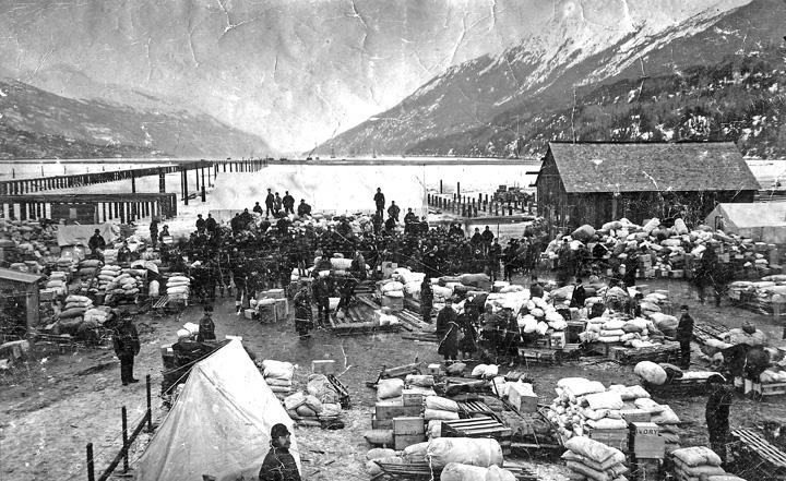

7 Dyea

8 Kinney Bridge

9 Finnegan's Point

10 Canyon City

11 Sheep Camp

12 Scales to Summit

13 Chilkoot Trail Artifacts

14 Types of Climate Change Threats

15 Types of Climate Change Threats

16 Types of Climate Change Threats

17 Types of Climate Change Threats

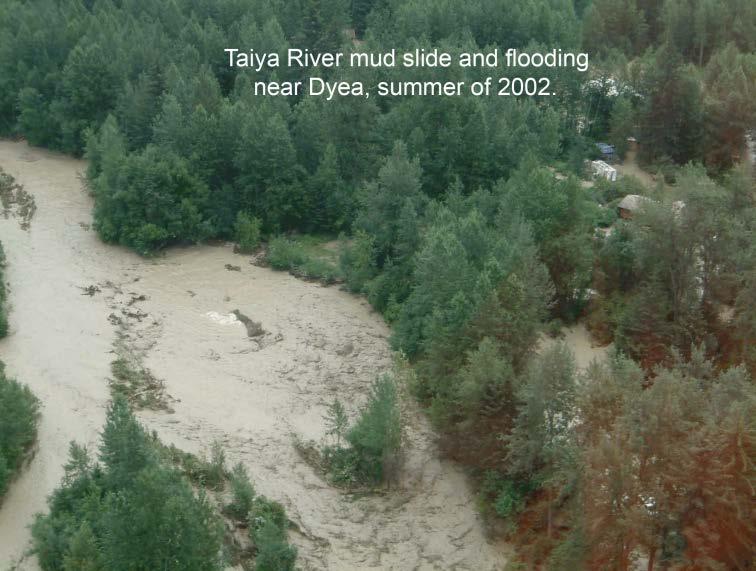
18 Fluvial Channel Instability Nourse and West Creek subsheds contribute most runoff to main stem of Taiya Lower Taiya is responding to a change in base level due to isostatic rebound Rebound rates in Dyea average 1.8 cm/yr

19 Fluvial Channel Instability Dyea Monitoring bank erosion since 1979 Most erosion occurred prior to 1992 Discrepancy between 10 and 20 meters Standardize protocol
20 Fluvial Channel Instability Kinney Bridge Erosion noticed in 2011

21 Fluvial Channel Instability Kinney Bridge Erosion noticed in 2011
22 Fluvial Channel Instability Kinney Bridge Erosion noticed in meters of bank loss per year CT14 and CT3 within 5 meters of 2016 bank Safest feature is 13 meters from 2016 bank More threatened than Dyea


23 Fluvial Channel Instability Finnegan's Point & Canyon City


24 Fluvial Channel Instability Sheep Camp 1994 surveys of west Sheep Camp Not digitized Sheep camp area is naturally prone to flooding and channel instability

25 Glacial Outburst Floods Glacial outburst floods (GLOF) occur when a dam (ice or earthen) containing a glacial lake fails Receding glaciers deposit their melt-water into proglacial lakes, increasing the lake volume and hazard risk should the dam fail Higher summer and winter temperatures encourage the melting of ice dams and ice-cored earthen dams TEMSCO, 2002


26 Sheep Camp Disaster - September 17, 1887 Damage was locally severe, but limited in extent. No extensive damage to Pleasant Camp and Canyon City Seattle Post-Intelligencer, 1897 A 20 foot high wall of water struck the main canyon at Stonehouse in such a way as to lift that great rock, weighing many tons, and to wash it a quarter of a mile down the canyon (Bearss, 1970)

27 Glacial Outburst Floods Three pro-glacial lakes with the potential to threaten cultural resources Nourse Lake and Hanging Lake could impact resources from Canyon City to Dyea


28 West Creek Lake Capps, 2003


29 Hanging Lake Separated from active glacier for at least 55 years No ice core Overlaying bedrock


30 Nourse Lake Lake surface is near crest of moraine dam Slopes above reservoir are subject to mass movement Predicted discharge of 1,600 m³/s Twice predicted 500-year flood discharge for Taiya River 3x discharge of 2002 West Creek flood

31 Earlier Snow Melt Material culture derives its significance from the place which it was deposited Every Place has a Climate Story initiative How can we see change happening in material culture?

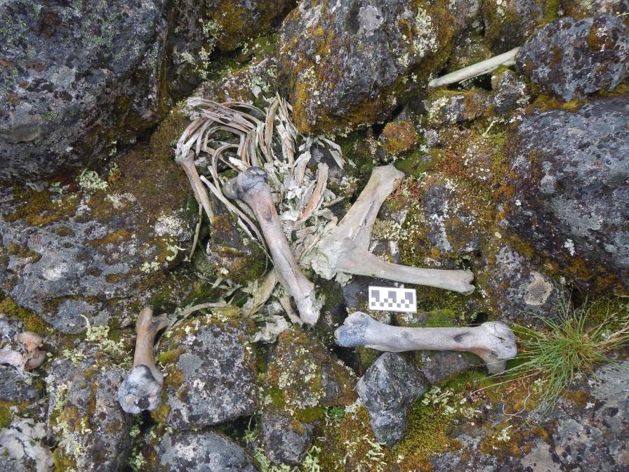

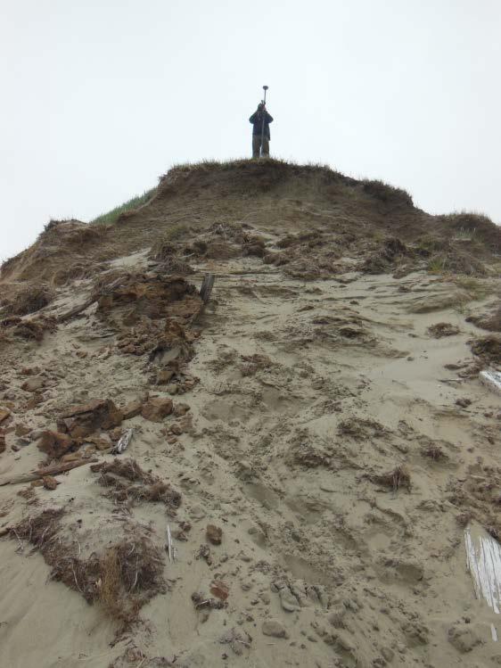
32 Melting Ice Patches
33 Climate Change Threats to Archaeological Resources Archaeological Site Taiya Channel Instability Glacial Outburst Floods Dyea X X Kinney Bridge X X Finnegan's Point Canyon City Sheep Camp X X X Early Snow Melt Melting Ice Patch Scales to Sumitt X X
34 Recommendations Site Risk Probability Time Frame Severity Significance Recommendation Dyea Channel Migration Possible Intermediate Marginal High Continue monitoring Kinney Bridge Channel Migration Certain Short term Catastrophic Moderate Annual spring monitoring and documentation Finnegan's Point Outburst Flood Possible Short term Catastrophic Low None Canyon City Outburst Flood Possible Short term Catastrophic High Documentation Sheep Camp Channel Migration Certain Long term Critical Moderate /High Documentation of western site Scales to Summit Snow/Ice Melt Certain Long term Marginal Moderate Documentation

35 Klondike Gold Rush National Historical Park Cultural Resources National Park Service U.S. Department of the Interior
The last three sections of the main body of this report consist of:
 Threatened and Endangered Species Geological Hazards Floodplains Cultural Resources Hazardous Materials A Cost Analysis section that provides comparative conceptual-level costs follows the Environmental
GEOSPATIAL ANALYSIS OF GLACIAL DYNAMICS OF SHIGAR AND SHAYOK BASINS. Syed Naseem Abbas Gilany 1
 GEOSPATIAL ANALYSIS OF GLACIAL DYNAMICS OF SHIGAR AND SHAYOK BASINS 1 OUTLINE Introduction Problem Statement / Rationale Objectives Material and Methods Study Area Datasets Required Data Analysis / Assessment
Stream Geomorphology. Leslie A. Morrissey UVM July 25, 2012
 Stream Geomorphology Leslie A. Morrissey UVM July 25, 2012 What Functions do Healthy Streams Provide? Flood mitigation Water supply Water quality Sediment storage and transport Habitat Recreation Transportation
Hazard Zonation for Glacial Lake Outburst Flood (GLOF) in Bhutan Himalaya
 in Bhutan Himalaya") Hazard Zonation for Glacial Lake Outburst Flood (GLOF) in Bhutan Himalaya A mode of Adaptation to the impacts of climate change DGM-NCAP Project Karma Department of Geology & Mines Ministry of Economic
Hazard Zonation for Glacial Lake Outburst Flood (GLOF) in Bhutan Himalaya A mode of Adaptation to the impacts of climate change DGM-NCAP Project Karma Department of Geology & Mines Ministry of Economic
THE ACTION OF GLACIERS
 Surface processes THE ACTION OF GLACIERS Glaciers are enormous masses of ice which are formed due to accumulation, compaction and re-crystallisation of the snow deposited in very cold regions (the majority
Bhutan Country Report for JPTM 2010 (July, 2010) Department of Disaster Management Ministry of Home & Cultural Affairs Royal Government of Bhutan
 Department of Disaster Management Ministry of Home & Cultural Affairs Royal Government of Bhutan") Bhutan Country Report for JPTM 2010 (July, 2010) Department of Disaster Management Ministry of Home & Cultural Affairs Royal Government of Bhutan 1 Contents of Presentation 1. Disaster Hazards and Underlying
Bhutan Country Report for JPTM 2010 (July, 2010) Department of Disaster Management Ministry of Home & Cultural Affairs Royal Government of Bhutan 1 Contents of Presentation 1. Disaster Hazards and Underlying
Sediment Deposition LET THE RIVER RUN T E A C H E R. Activity Overview. Activity at a Glance. Time Required. Level of Complexity.
 Activity at a Glance Grade: 6 9 Subject: Science Category: Physical Science, Earth Science Topic: Deposition, River Systems Time Required Two 45-minute periods Level of Complexity Medium Materials* TI-73
Section 11.1 pp Where Mountains Form
 Section 11.1 pp. 236 237 Where Mountains Form Chapter 11 Set a Purpose: TE, p. 236 Reading Study Guide, p. 36 Discussion: TE, p. 236 Differentiating ion Reading Support: TE, p. 236 Visual Teaching Interpret
UGRC 144 Science and Technology in Our Lives/Geohazards
 UGRC 144 Science and Technology in Our Lives/Geohazards Flood and Flood Hazards Dr. Patrick Asamoah Sakyi Department of Earth Science, UG, Legon College of Education School of Continuing and Distance Education
1 City of Edmonton Quesnell Bridge, Roads and Associated Structures Assessment
 1 City of Edmonton Quesnell Bridge, Roads and Associated Structures Assessment 1.1 Background Within the First National Engineering Vulnerability Assessment, the Public Infrastructure Engineering Vulnerability
Orting Community College Proposal
 Orting Community College Proposal Cedric, Celina, Francine, Sarah, Samuel GEO CORP Located in Washington, 42 miles south of Seattle. Situated between two rivers on fertile plains. Built on lahar deposits.
Amazing Ice: Glaciers and Ice Ages
 Amazing Ice: Glaciers and Ice Ages Updated by: Rick Oches, Professor of Geology & Environmental Sciences Bentley University Waltham, Massachusetts Based on slides prepared by: Ronald L. Parker, Senior
1. INTRODUCTION. EXAMPLE OF SECHILIENNE ROCKFALL (France)
") FORM OSE POST-GRADUATE COURSE Landslide vulnerability and risk 1 FORM OSE POST-GRADUATE COURSE Landslide vulnerability and risk 2 FORM OSE POST-GRADUATE COURSE Landslide vulnerability and risk 3 Christophe
FORM OSE POST-GRADUATE COURSE Landslide vulnerability and risk 1 FORM OSE POST-GRADUATE COURSE Landslide vulnerability and risk 2 FORM OSE POST-GRADUATE COURSE Landslide vulnerability and risk 3 Christophe
Influence of the timing of flood events on sediment yield in the north-western Algeria
 Calabria, 5-7 Septembre 2 4th International Workshop on Hydrological Extremes Session A : Modelling and forecast of hydrological extreme event Influence of the timing of flood events on sediment yield
Conceptual Model of Stream Flow Processes for the Russian River Watershed. Chris Farrar
 Conceptual Model of Stream Flow Processes for the Russian River Watershed Chris Farrar Several features of creeks affect the interactions between surface and groundwater. This conceptual model uses the
Science EOG Review: Landforms
 Mathematician Science EOG Review: Landforms Vocabulary Definition Term canyon deep, large, V- shaped valley formed by a river over millions of years of erosion; sometimes called gorges (example: Linville
UIB Network - TWG 5 Hazards and risks:
 UIB Network - TWG 5 Hazards and risks: Philippus Wester & Muhammad Asif Khan ICIMOD & Karakoram International university TWG-5 members: Arun Shrestha, Liu Shiyin, Nusrat Nasab, Deedar Karim, Muhammad Zafar
DISASTER HAZARDS IN BHUTAN By Tshewang Rinzin January Reducing Disaster Risks for a Safe and Happy Bhutan
 DISASTER HAZARDS IN BHUTAN By Tshewang Rinzin 26-27 January 2009 Reducing Disaster Risks for a Safe and Happy Bhutan Disaster Hazards in Bhutan Earthquakes Glacial Lake Outburst Flood (GLOF) Floods in
3.12 Geology and Topography Affected Environment
 3 Affected Environment and Environmental Consequences 3.12 Geology and Topography 3.12.1 Affected Environment 3.12.1.1 Earthquakes Sterling Highway MP 45 60 Project Draft SEIS The Kenai Peninsula is predisposed
SECTION II Hydrological risk
 Chapter 3 Understanding disaster risk: hazard related risk issues SECTION II Hydrological risk Peter Salamon Coordinating lead author Hannah Cloke Lead author 3.4 Giuliano di Baldassarre Owen Landeg Florian
5.2. IDENTIFICATION OF NATURAL HAZARDS OF CONCERN
 5.2. IDENTIFICATION OF NATURAL HAZARDS OF CONCERN To provide a strong foundation for mitigation strategies considered in Sections 6 and 9, County considered a full range of natural hazards that could impact
Waterbury Dam Disturbance Mike Fitzgerald Devin Rowland
 Waterbury Dam Disturbance Mike Fitzgerald Devin Rowland Abstract The Waterbury Dam was completed in October 1938 as a method of flood control in the Winooski Valley. The construction began in April1935
Grade 8 Science. Unit 1: Water Systems on Earth Chapter 1
 Grade 8 Science Unit 1: Water Systems on Earth Chapter 1 Effects of Water? Churchill River Large Ocean Wave How do you use water? House Hold Use Personal Use Recreational Activities Water Distribution
Floods Lecture #21 20
 Floods 20 Lecture #21 What Is a Flood? Def: high discharge event along a river! Due to heavy rain or snow-melt During a flood, a river:! Erodes channel o Deeper & wider! Overflows channel o Deposits sediment
Appendix C Fluvial Flood Hazards
 Appendix C Fluvial Flood Hazards Sea Level Rise Vulnerability Assessment and Adaptation Project March 2019 Contents Contents... i Figures... i Tables... i Definitions, Acronyms, & Abbreviations... ii
Red River Levee Panel
 Red River Levee Panel Mississippi River Commission Monday, August 9, 2017 Red River Levees in LA & AR NONE along TX & OK Boarder Red River Levee Issues Caddo Levee Cherokee Park Authorization Bossier Levee
Erosion Information Paper Eagle City and Eagle Village, Alaska Current as of January 21, 2008
 U.S. Army Corps of Engineers ALASKA BASELINE EROSION ASSESSMENT Erosion Information Paper Eagle City and Eagle Village, Alaska Current as of January 21, 2008 Community Information The City of Eagle, population
1. The map below shows a meandering river. A A' is the location of a cross section. The arrows show the direction of the river flow.
 1. The map below shows a meandering river. A A' is the location of a cross section. The arrows show the direction of the river flow. Which cross section best represents the shape of the river bottom at
Glacier Hydrology. Why should you care?
 Glacier Hydrology Why should you care? Climate Local Meteorology Surface Mass And Energy Exchange Net Mass Balance Dynamic Response Effect on Landscape Changes In Geometry Water Flow PRACTICAL MATTERS:
EARTH S SYSTEMS: PROCESSES THAT SHAPE THE EARTH
 9 Week Unit UNIT 2 EARTH S SYSTEMS: PROCESSES THAT SHAPE THE EARTH Fourth Grade Rogers Public Schools : Earth s Systems: Processes that Shape the Earth 9 weeks In this unit, students develop understandings
Name: Which rock layers appear to be most resistant to weathering? A) A, C, and E B) B and D
 A, C, and E B) B and D") Name: 1) The formation of soil is primarily the result of A) stream deposition and runoff B) precipitation and wind erosion C) stream erosion and mass movement D) weathering and biological activity 2)
Name: 1) The formation of soil is primarily the result of A) stream deposition and runoff B) precipitation and wind erosion C) stream erosion and mass movement D) weathering and biological activity 2)
Term Knowledge Using and applying Grade Criteria Autumn 1 Assessment window October Natural hazards pose major risks to people and property.
 Assessment Schedule Year 9 2015/6 Term Knowledge Using and applying Grade Criteria Autumn 1 Assessment window October 2015 3.1.1.2 Tectonic Natural hazards pose major risks to people and property. Definition
Guided Notes Surface Processes. Erosion & Deposition By: Glaciers
 Guided Notes Surface Processes Erosion & Deposition By: Glaciers K. Coder 2015 26) How does moving ice erode and deposit sediments? Glaciers (Movement of Ice): a naturally formed mass of ice and snow that
Your web browser (Safari 7) is out of date. For more security, comfort and the best experience on this site: Update your browser Ignore
 is out of date. For more security, comfort and the best experience on this site: Update your browser Ignore") Your web browser (Safari 7) is out of date. For more security, comfort and the best experience on this site: Update your browser Ignore ALLU VIAL FAN colluvial fan, debris cone For the complete encyclopedic
Your web browser (Safari 7) is out of date. For more security, comfort and the best experience on this site: Update your browser Ignore ALLU VIAL FAN colluvial fan, debris cone For the complete encyclopedic
EROSION HAZARD OF MINNESOTA'S LAKE SUPERIOR SHORELINE. Carol A. Johnston Principal Investigator
 EROSION HAZARD OF MINNESOTA'S LAKE SUPERIOR SHORELINE Carol A. Johnston Principal Investigator Maps prepared by: James Salés, John Bonde, Tim Aunan, and Richard Raby Minnesota Sea Grant Research Bulletin
Assessment of the catastrophic events originated in the river Vere basin
 Assessment of the catastrophic events originated in the river Vere basin Tbilisi, Georgia Presenter: Irakli Megrelidze Deputy Head of Hydrometeorological Department (National Environmental Agency) Hydrology
2018 Geography Mock Examination
 2018 Geography Mock Examination Your Geography mock examination will test your understanding of Paper 1 (Living with the physical environment) and Section B (Fieldwork) from Paper 2. Attached are the necessary
Timing and magnitude of late Pleistocene and Holocene glaciations in Yosemite National Park
 National Park Service U.S. Department of the Interior Yosemite National Park Timing and magnitude of late Pleistocene and Holocene glaciations in Yosemite National Park Greg Stock Yosemite National Park
Hydrologic Forecast Centre Manitoba Infrastructure, Winnipeg, Manitoba. MARCH OUTLOOK REPORT FOR MANITOBA March 23, 2018
 Page 1 of 21 Hydrologic Forecast Centre Manitoba Infrastructure, Winnipeg, Manitoba MARCH OUTLOOK REPORT FOR MANITOBA March 23, 2018 Overview The March Outlook Report prepared by the Hydrologic Forecast
Assessment of the Hood River Delta Hood River, Oregon
 Assessment of the Hood River Delta Hood River, Oregon Pacific Northwest Waterways Association Annual Meeting October 13, 2010 Michael McElwee, Executive Director Port of Hood River Overview U.S. Army Corps
Alaska, USA. Sam Robbins
 Using ArcGIS to determine erosion susceptibility within Denali National Park, Alaska, USA Sam Robbins Introduction Denali National Park is six million acres of wild land with only one road and one road
Which map shows the stream drainage pattern that most likely formed on the surface of this volcano? A) B)
 B)") 1. When snow cover on the land melts, the water will most likely become surface runoff if the land surface is A) frozen B) porous C) grass covered D) unconsolidated gravel Base your answers to questions
1. When snow cover on the land melts, the water will most likely become surface runoff if the land surface is A) frozen B) porous C) grass covered D) unconsolidated gravel Base your answers to questions
Surface Water Short Study Guide
 Name: Class: Date: Surface Water Short Study Guide Multiple Choice Identify the letter of the choice that best completes the statement or answers the question. 1. The three ways in which a stream carries
East Penn School District Curriculum and Instruction
 East Penn School District Curriculum and Instruction Curriculum for: Geology of National Parks Course(s): Geology of the National Parks Grades: 10-12 Department: Science Length of Period (average minutes):
mountain rivers fixed channel boundaries (bedrock banks and bed) high transport capacity low storage input output
 high transport capacity low storage input output") mountain rivers fixed channel boundaries (bedrock banks and bed) high transport capacity low storage input output strong interaction between streams & hillslopes Sediment Budgets for Mountain Rivers Little
mountain rivers fixed channel boundaries (bedrock banks and bed) high transport capacity low storage input output strong interaction between streams & hillslopes Sediment Budgets for Mountain Rivers Little
SLOPE PROCESSES, LANDSLIDES, AND SUBSIDENCE
 CHAPTER 9 SLOPE PROCESSES, LANDSLIDES, AND SUBSIDENCE La Conchita slide January 10, 2005 Triggered by heavy rainfall, reactivation along an older landslide surface (35,000 years ago, 6000 years ago, and
3/3/2013. The hydro cycle water returns from the sea. All "toilet to tap." Introduction to Environmental Geology, 5e
 Introduction to Environmental Geology, 5e Running Water: summary in haiku form Edward A. Keller Chapter 9 Rivers and Flooding Lecture Presentation prepared by X. Mara Chen, Salisbury University The hydro
Copernicus Overview. Major Emergency Management Conference Athlone 2017
 Copernicus Overview Major Emergency Management Conference Athlone 2017 Copernicus is a European programme implemented by the European Commission. The services address six thematic areas: land, marine,
Modeling Great Britain s Flood Defenses. Flood Defense in Great Britain. By Dr. Yizhong Qu
 Modeling Great Britain s Flood Defenses AIRCurrents Editor s note: AIR launched its Inland Flood Model for Great Britain in December 2008. The hazard module captures the physical processes of rainfall-runoff
An overview of the applications for early warning and mapping of the flood events in New Brunswick
 Flood Recovery, Innovation and Reponse IV 239 An overview of the applications for early warning and mapping of the flood events in New Brunswick D. Mioc 1, E. McGillivray 2, F. Anton 1, M. Mezouaghi 2,
Disaster RISK Management : Bhutanese Scenario
 Disaster RISK Management : Bhutanese Scenario Expert Group Meeting (EGM) on Geo-referenced Information Systems for Disaster Risk Management (Geo-DRM) and sustaining the Community of Practice (COP), Bangkok,
What the. Just happened? THOMPSON WATERSHED DISASTER MITIGATION COMMUNITY FORUM FEBRUARY 14, 2018 Dwayne Meredith, P.Ag.
 What the Just happened? THOMPSON WATERSHED DISASTER MITIGATION COMMUNITY FORUM FEBRUARY 14, 2018 Dwayne Meredith, P.Ag. Agenda Historic context and recent events Policy and scientific information Why this
Fluvial Systems Lab Environmental Geology Lab Dr. Johnson
 Fluvial Systems Lab Environmental Geology Lab Dr. Johnson *Introductory sections of this lab were adapted from Pidwirny, M. (2006). "Streamflow and Fluvial Processes". Fundamentals of Physical Geography,
Flash flood disaster in Bayangol district, Ulaanbaatar
 Flash flood disaster in Bayangol district, Ulaanbaatar Advanced Training Workshop on Reservoir Sedimentation Management 10-16 October 2007. IRTCES, Beijing China Janchivdorj.L, Institute of Geoecology,MAS
investment decisions
 Climate modelling: A guide to investment decisions Vicky Pope Met Office Hadley Centre This is not an ADB material. The views expressed in this document are the views of the author/s and/or their organizations
Souris River Basin Spring Runoff Outlook As of March 15, 2018
 Souris River Basin Spring Runoff Outlook As of March 15, 2018 Prepared by: Flow Forecasting & Operations Planning Water Security Agency Basin Conditions Summer rainfall in 2017 in the Saskatchewan portion
PiXL Independence: Geography Answer Booklet KS4. AQA Style, UK Physical Landscapes. Contents: Answers
 PiXL Independence: Geography Answer Booklet KS4 AQA Style, UK Physical Landscapes Contents: Answers 1 I. Multiple Choice Questions 1 Where in the UK would you describe as having large areas of uplands?
RISK ASSESSMENT COMMUNITY PROFILE NATURAL HAZARDS COMMUNITY RISK PROFILES. Page 13 of 524
 RISK ASSESSMENT COMMUNITY PROFILE NATURAL HAZARDS COMMUNITY RISK PROFILES Page 13 of 524 Introduction The Risk Assessment identifies and characterizes Tillamook County s natural hazards and describes how
In the space provided, write the letter of the description that best matches the term or phrase. a. any form of water that falls to Earth s
 Skills Worksheet Concept Review In the space provided, write the letter of the description that best matches the term or phrase. 1. condensation 2. floodplain 3. watershed 4. tributary 5. evapotranspiration
STRUCTURAL STABILITY ASSESSMENT
 STRUCTURAL STABILITY ASSESSMENT CFR 257.73(d) Bottom Ash Pond Complex Cardinal Plant Brilliant, Ohio October, 2016 Prepared for: Cardinal Operating Company Cardinal Plant Brilliant, Ohio Prepared by: Geotechnical
Hydrologic Forecast Centre Manitoba Infrastructure, Winnipeg, Manitoba. FEBRUARY OUTLOOK REPORT FOR MANITOBA February 23, 2018
 Page 1 of 17 Hydrologic Forecast Centre Manitoba Infrastructure, Winnipeg, Manitoba FEBRUARY OUTLOOK REPORT FOR MANITOBA February 23, 2018 Overview The February Outlook Report prepared by the Hydrologic
Science of Natural Disasters: RIVERS& FLOODS! 27 April 2016
 Science of Natural Disasters: RIVERS& FLOODS! 27 April 2016 Rebecca Clotts Department of Geology, University of St Thomas Flood in St Paul, 2014, Star Tribune 1 2 What is a watershed? 3 4 5 6 7 What is
Important Concepts. Earthquake hazards can be categorized as:
 Lecture 1 Page 1 Important Concepts Monday, August 17, 2009 1:05 PM Earthquake Engineering is a branch of Civil Engineering that requires expertise in geology, seismology, civil engineering and risk assessment.
1 INTRODUCTION AND MAJOR FINDINGS... 1
 Memorandum To: Lindsey Clark, Stillwater Valley Watershed Council Coordinator From: Chad Raisland, Pioneer Technical Services, Inc. and Karin Boyd, Applied Geomorphology, Inc. CC: Tanya Lester, Stillwater
Data challenges in Trans-boundary River Basins: Case Study of the Upper Indus Basin
 Data challenges in Trans-boundary River Basins: Case Study of the Upper Indus Basin Asif Khan Lead Author (Water chapter- AR6 IPCC) Post Doctorate (Water-Energy-Food-Climate Change, IIASA, Austria) PhD
Field Observations and One-Dimensional Flow Modeling of Summit Creek in Mack Park, Smithfield, Utah
 Intermountain Center for River Rehabilitation and Restoration, Utah State University 31 July 2018 Field Observations and One-Dimensional Flow Modeling of Summit Creek in Mack Park, Smithfield, Utah I.
2017 Fall Conditions Report
 2017 Fall Conditions Report Prepared by: Hydrologic Forecast Centre Date: November 15, 2017 Table of Contents TABLE OF FIGURES... ii EXECUTIVE SUMMARY... 1 BACKGROUND... 4 SUMMER AND FALL PRECIPITATION...
2017 January Conditions Report Manitoba Hydrologic Forecasting and Coordination Branch Manitoba Infrastructure
 2017 January Conditions Report Manitoba Hydrologic Forecasting and Coordination Branch Manitoba Infrastructure 1/30/2017 Page 1 of 22 Hydrologic Forecast Centre Manitoba Infrastructure and Transportation
3.18 GEOLOGY AND SOILS
 3.18 GEOLOGY AND SOILS This section discusses geologic resource concerns as they relate to the environment, public safety, and project design both during construction and after completion of the project.
Lecture Outlines PowerPoint. Chapter 6 Earth Science 11e Tarbuck/Lutgens
 Lecture Outlines PowerPoint Chapter 6 Earth Science 11e Tarbuck/Lutgens 2006 Pearson Prentice Hall This work is protected by United States copyright laws and is provided solely for the use of instructors
1. Which type of climate has the greatest amount of rock weathering caused by frost action? A) a wet climate in which temperatures remain below
 a wet climate in which temperatures remain below") 1. Which type of climate has the greatest amount of rock weathering caused by frost action? A) a wet climate in which temperatures remain below freezing B) a wet climate in which temperatures alternate
1. Which type of climate has the greatest amount of rock weathering caused by frost action? A) a wet climate in which temperatures remain below freezing B) a wet climate in which temperatures alternate
8 th 12 th Designing a Monitoring Plan Mapping & Analysis (Activities 1 2)
") 8 th 12 th Designing a Monitoring Plan Mapping & Analysis (Activities 1 2) Objectives for All Activities - To be able to define and describe the purpose and uses of topographic maps. - To define rules
8 th 12 th Designing a Monitoring Plan Mapping & Analysis (Activities 1 2) Objectives for All Activities - To be able to define and describe the purpose and uses of topographic maps. - To define rules
Cattaraugus Creek: A Story of Flowing Water and the Geology of the Channel It Flows Through Presentation to West Valley Citizen Task Force 4/27/16
 Cattaraugus Creek: A Story of Flowing Water and the Geology of the Channel It Flows Through Presentation to West Valley Citizen Task Force 4/27/16 Raymond C. Vaughan, Ph.D. What happens if you drop a
GEOLOGY CURRICULUM. Unit 1: Introduction to Geology
 Chariho Regional School District - Science Curriculum September, 2016 GEOLOGY CURRICULUM Unit 1: Introduction to Geology OVERVIEW Summary In this unit students will be introduced to the field of geology.
Griswold Creek August 22, 2013
 Creek August 22, 2013 1 Lake Erie Protection Fund Creek Study ver Evaluate the overall condition of Creek Determine stable channel dimensions & appropriate restoration techniques Starting Stat gpoint for
Heavy Rain and Potential for Dangerous Flooding for northeast SC and southeast NC
 US National Weather Service Wilmington NC @NWSWilmingtonNC http://weather.gov/ilm ***Life Threatening Flooding Possible*** Heavy Rain and Potential for Dangerous Flooding for northeast SC and southeast
Bipole III Transmission Project Construction Environmental Protection Plan Construction Section N2 Environmentally Sensitive Site Locations Map 81
 ± DOCUMENT PATH: G :\_GIS_PROJECT_FOLDER\00_HYDRO\111440054_BPIII_EPP\ARCMAP\ESS_N2\BPIII_CENVPP_N1N2N3N4C1SECTIONBASEMAP_MAPBOOK_BTB_STANTEC_20131201.MXD 196 Coordinate System: UTM Zone NAD83 Data Source:
Pat Dryer Half Moon Lake: A True Oxbow Lake? Geography 364 April 1 st, 2007
 Pat Dryer Half Moon Lake: A True Oxbow Lake? Geography 364 April 1 st, 2007 Appendix Abstract 2 Introduction 3 Methods 3 Results 3 Discussion 5 Conclusion 11 1 Abstract Half Moon Lake appears to be an
ANALYSIS OF GLACIER CHANGE IN THE SIERRA NEVADA PORTLAND STATE UNIVERSITY DEPARTMENT OF GEOLOGY BRADLEY BUSELLI
 ANALYSIS OF GLACIER CHANGE IN THE SIERRA NEVADA PORTLAND STATE UNIVERSITY DEPARTMENT OF GEOLOGY BRADLEY BUSELLI Study area: Sierra Nevada (Glaciers, 2015) Closer look (Glaciers, 2015) Primary goal: Research
Souris River Basin Spring Runoff Outlook As of March 1, 2019
 Souris River Basin Spring Runoff Outlook As of March 1, 2019 Prepared by: Flow Forecasting & Operations Planning Water Security Agency Basin Conditions Summer rainfall in 2018 over the Saskatchewan portion
Science Matters. Grade Six Earth Science. Weathering and Erosion
 Science Matters Grade Six Earth Science Weathering and Erosion Written By Kim Castagna Jennifer Foster Meagan Callahan Tracy Schifferns Developed in Conjunction with K-12 Alliance/WestEd Table of Contents
A River Runs Through It
 A River Runs Through It Once you find the geocache, click "Found It" on the Geocaching.com app and then read and answer the questions below. Make sure to return the cache to exactly the same place you
Discussion Paper on the Impacts of Climate Change for Mount Pearl. August, Darlene Butler. Planning Department. City of Mount Pearl
 Discussion Paper on the Impacts of Climate Change for Mount Pearl August, 2008 Darlene Butler Planning Department City of Mount Pearl 3 Centennial Street Mount Pearl, NL A1N 1G4 (709) 748 1022 Table of
SEISMIC RISK ASSESSMENT IN ARMENIA
 SEISMIC RISK ASSESSMENT IN ARMENIA Hovhannes Khangeldyan Head of National Crisis Management Center Rescue Service Ministry of Emergency Situations of the Republic of Armenia Tokyo, 2016 ARMENIA: GEOGRAPHICAL
The subject paper is being submitted for approval for publication in the annual volume entitled Geological Survey Research.
 Water Resources Division 345 Middlefield Road Menlo Park, California January 12, 1965 Memorandum To: Mr. Frank E. Clark, Chief, General Hydrology Branch Thru: Area Hydrologist PCA From: Valmore C. LaMarche
Water, geology, climate & soils: Sierra Nevada, Merced River & Central Valley connections
 Water, geology, climate & soils: Sierra Nevada, Merced River & Central Valley connections Geography & geology Merced River basin Climate & hydrology Soils & soil formation Roger Bales UC Merced Water,
Ice Cap Glaciers in the Arctic Region. John Evans Glacier, Ellesmere Island (Robert Bingham, U. Aberdeen)
") Ice Cap Glaciers in the Arctic Region John Evans Glacier, Ellesmere Island (Robert Bingham, U. Aberdeen) Iceland Svalbard Ellesmere and Baffin Islands Severny and Anzhu Islands Topics: Temperate vs non-temperate
Ice Cap Glaciers in the Arctic Region John Evans Glacier, Ellesmere Island (Robert Bingham, U. Aberdeen) Iceland Svalbard Ellesmere and Baffin Islands Severny and Anzhu Islands Topics: Temperate vs non-temperate
1. Any process that causes rock to crack or break into pieces is called physical weathering. Initial product = final product
 Weathering 1. Any process that causes rock to crack or break into pieces is called physical weathering. Initial product = final product End Result of physical weathering is increased surface area. 2. Physical
Flood Scenario Worksheet
 Flood Scenario Worksheet Scenario adapted from: http://www.epa.gov/watersecurity/tools/trainingcd/simple/source/scenario-8/ssc8-0.pdf Simple Tabletop Exercise, Interdependency Natural Disaster Scenario,
WSWC/NOAA Workshops on S2S Precipitation Forecasting
 WSWC/NOAA Workshops on S2S Precipitation Forecasting San Diego, May 2015 Salt Lake City at NWS Western Region HQ, October 2015 Las Vegas at Colorado River Water Users Association, December 2015 College
Assessment of possible jôkulhlaups from Lake Demmevatn in Norway
 The Eslrciui's of flu' Extremes: Eflraortlinarv Floods (Proceedings of ;i svinposinm held ill Reykjavik. Iceland. July 2000). IAliSPubl.no. 271. 2002. 31 Assessment of possible jôkulhlaups from Lake Demmevatn
How Can DOT Operations and Maintenance Prepare for Extreme Weather Events?
 How Can DOT Operations and Maintenance Prepare for Extreme Weather Events? Gregory C. Johnson, P.E. Chief Operations Officer Michigan Department of Transportation November 17, 2012 Michigan s Climate Four
Guide to Streamgauging Sites in the Tuolumne River Drainage
 Guide to Streamgauging Sites in the Tuolumne River Drainage measurements by Jessica Lundquist, Brian Huggett, Jim Roche, Mike Dettinger, Dan Cayan, Dave Peterson, and Rich Smith version 1.2 October 3,
Waterways from glaciers to coastal waters in Iceland. Jórunn Harðardóttir, IMO Nordic WFD conference September 26, 2012
 Waterways from glaciers to coastal waters in Iceland Jórunn Harðardóttir, IMO Nordic WFD conference September 26, 2012 What to include and what not to include? Hydrology of Iceland Much on glaciers and
FLOOD REPORT FOR MANITOBA. April 11, :00 am
 FLOOD REPORT FOR MANITOBA April 11, 2017 9:00 am Overland flooding and tributary flows are subsiding across much of southern Manitoba. Flows on northern rivers are ice covered and are responding to runoff.
CAPE Unit 1 Module 2 & 3. Topic Specific Objectives Content Explain the main concepts, flows and processes associated with coastal environments
 # Week(s) Wks 1-3 CAPE Unit 1 Module 2 & 3 Topic Specific Objectives Content Explain the main concepts, flows and processes associated with coastal environments Wave formation, structure, types Textbook
¾À 280. ESS Features Heritage. Points of Access* !( Proposed Access Point. !( Archaeological Water. Major Stream Crossing Abandoned Rail Crossing # #
 ± DOCUMENT PATH: G :\_GIS_PROJECT_FOLDER\00_HYDRO\111440054_BPIII_EPP\ARCMAP\ESS_N1\BPIII_CENVPP_N1N2N3N4C1SECTIONBASEMAP_MAPBOOK_BTB_STANTEC_20131207.MXD 386 N1-S30 385 BURNTWOOD RIVER Coordinate System:
Flooding in Manayunk Neighborhood of Philadelphia
 Flooding in Manayunk Neighborhood of Philadelphia Samuel Brodfuehrer GIS in Water Resources December 8, 2017 Introduction... 3 Philadelphia Overview... 3 Manayunk Overview... 4 Project Objective... 6 Methods
Flooding. April 21, Notes 4/20 CONGRATULATIONS!!!!! Activity 2: AZ State Museum due TODAY. Extra Credit 2: Returned at end of class
 April 21, 2011 Flooding 1927 Mississippi Flood Notes 4/20 Activity 2: AZ State Museum due TODAY Extra Credit 2: Returned at end of class CONGRATULATIONS!!!!! Andrew Richard Undergraduate Research Grant
Climate change and adaptation of the aviation community
 Climate change and adaptation of the aviation community Sigrún Karlsdóttir, Halldór Björnsson, Trausti Jónsson Icelandic Meteorological Office International Air Safety & Climate Change conference EASA