THESE TERMS GOVERN YOUR USE OF THIS DOCUMENT
|
|
|
- Leslie Robbins
- 5 years ago
- Views:
Transcription
1 THESE TERMS GOVERN YOUR USE OF THIS DOCUMENT Your use of this Ontario Geological Survey document (the Content ) is governed by the terms set out on this page ( Terms of Use ). By downloading this Content, you (the User ) have accepted, and have agreed to be bound by, the Terms of Use. Content: This Content is offered by the Province of Ontario s Ministry of Northern Development and Mines (MNDM) as a public service, on an as-is basis. Recommendations and statements of opinion expressed in the Content are those of the author or authors and are not to be construed as statement of government policy. You are solely responsible for your use of the Content. You should not rely on the Content for legal advice nor as authoritative in your particular circumstances. Users should verify the accuracy and applicability of any Content before acting on it. MNDM does not guarantee, or make any warranty express or implied, that the Content is current, accurate, complete or reliable. MNDM is not responsible for any damage however caused, which results, directly or indirectly, from your use of the Content. MNDM assumes no legal liability or responsibility for the Content whatsoever. Links to Other Web Sites: This Content may contain links, to Web sites that are not operated by MNDM. Linked Web sites may not be available in French. MNDM neither endorses nor assumes any responsibility for the safety, accuracy or availability of linked Web sites or the information contained on them. The linked Web sites, their operation and content are the responsibility of the person or entity for which they were created or maintained (the Owner ). Both your use of a linked Web site, and your right to use or reproduce information or materials from a linked Web site, are subject to the terms of use governing that particular Web site. Any comments or inquiries regarding a linked Web site must be directed to its Owner. Copyright: Canadian and international intellectual property laws protect the Content. Unless otherwise indicated, copyright is held by the Queen s Printer for Ontario. It is recommended that reference to the Content be made in the following form: <Author s last name>, <Initials> <year of publication>. <Content title>; Ontario Geological Survey, <Content publication series and number>, <total number of pages>p. Use and Reproduction of Content: The Content may be used and reproduced only in accordance with applicable intellectual property laws. Non-commercial use of unsubstantial excerpts of the Content is permitted provided that appropriate credit is given and Crown copyright is acknowledged. Any substantial reproduction of the Content or any commercial use of all or part of the Content is prohibited without the prior written permission of MNDM. Substantial reproduction includes the reproduction of any illustration or figure, such as, but not limited to graphs, charts and maps. Commercial use includes commercial distribution of the Content, the reproduction of multiple copies of the Content for any purpose whether or not commercial, use of the Content in commercial publications, and the creation of value-added products using the Content. Contact: FOR FURTHER INFORMATION ON The Reproduction of Content The Purchase of MNDM Publications PLEASE CONTACT: BY TELEPHONE: BY MNDM Publication Services MNDM Publication Sales Local: (705) Toll Free: , ext (inside Canada, United States) Local: (705) Toll Free: , ext (inside Canada, United States) Crown Copyright Queen s Printer Local: (416) Toll Free: (inside Canada, United States) Pubsales@ndm.gov.on.ca Pubsales@ndm.gov.on.ca Copyright@gov.on.ca
2 LES CONDITIONS CI-DESSOUS RÉGISSENT L'UTILISATION DU PRÉSENT DOCUMENT. Votre utilisation de ce document de la Commission géologique de l'ontario (le «contenu») est régie par les conditions décrites sur cette page («conditions d'utilisation»). En téléchargeant ce contenu, vous (l'«utilisateur») signifiez que vous avez accepté d'être lié par les présentes conditions d'utilisation. Contenu : Ce contenu est offert en l'état comme service public par le ministère du Développement du Nord et des Mines (MDNM) de la province de l'ontario. Les recommandations et les opinions exprimées dans le contenu sont celles de l'auteur ou des auteurs et ne doivent pas être interprétées comme des énoncés officiels de politique gouvernementale. Vous êtes entièrement responsable de l'utilisation que vous en faites. Le contenu ne constitue pas une source fiable de conseils juridiques et ne peut en aucun cas faire autorité dans votre situation particulière. Les utilisateurs sont tenus de vérifier l'exactitude et l'applicabilité de tout contenu avant de l'utiliser. Le MDNM n'offre aucune garantie expresse ou implicite relativement à la mise à jour, à l'exactitude, à l'intégralité ou à la fiabilité du contenu. Le MDNM ne peut être tenu responsable de tout dommage, quelle qu'en soit la cause, résultant directement ou indirectement de l'utilisation du contenu. Le MDNM n'assume aucune responsabilité légale de quelque nature que ce soit en ce qui a trait au contenu. Liens vers d'autres sites Web : Ce contenu peut comporter des liens vers des sites Web qui ne sont pas exploités par le MDNM. Certains de ces sites pourraient ne pas être offerts en français. Le MDNM se dégage de toute responsabilité quant à la sûreté, à l'exactitude ou à la disponibilité des sites Web ainsi reliés ou à l'information qu'ils contiennent. La responsabilité des sites Web ainsi reliés, de leur exploitation et de leur contenu incombe à la personne ou à l'entité pour lesquelles ils ont été créés ou sont entretenus (le «propriétaire»). Votre utilisation de ces sites Web ainsi que votre droit d'utiliser ou de reproduire leur contenu sont assujettis aux conditions d'utilisation propres à chacun de ces sites. Tout commentaire ou toute question concernant l'un de ces sites doivent être adressés au propriétaire du site. Droits d'auteur : Le contenu est protégé par les lois canadiennes et internationales sur la propriété intellectuelle. Sauf indication contraire, les droits d'auteurs appartiennent à l'imprimeur de la Reine pour l'ontario. Nous recommandons de faire paraître ainsi toute référence au contenu : nom de famille de l'auteur, initiales, année de publication, titre du document, Commission géologique de l'ontario, série et numéro de publication, nombre de pages. Utilisation et reproduction du contenu : Le contenu ne peut être utilisé et reproduit qu'en conformité avec les lois sur la propriété intellectuelle applicables. L'utilisation de courts extraits du contenu à des fins non commerciales est autorisé, à condition de faire une mention de source appropriée reconnaissant les droits d'auteurs de la Couronne. Toute reproduction importante du contenu ou toute utilisation, en tout ou en partie, du contenu à des fins commerciales est interdite sans l'autorisation écrite préalable du MDNM. Une reproduction jugée importante comprend la reproduction de toute illustration ou figure comme les graphiques, les diagrammes, les cartes, etc. L'utilisation commerciale comprend la distribution du contenu à des fins commerciales, la reproduction de copies multiples du contenu à des fins commerciales ou non, l'utilisation du contenu dans des publications commerciales et la création de produits à valeur ajoutée à l'aide du contenu. Renseignements : POUR PLUS DE RENSEIGNEMENTS SUR la reproduction du contenu l'achat des publications du MDNM les droits d'auteurs de la Couronne VEUILLEZ VOUS ADRESSER À : Services de publication du MDNM Vente de publications du MDNM Imprimeur de la Reine PAR TÉLÉPHONE : PAR COURRIEL : Local : (705) Numéro sans frais : , poste 5691 (au Canada et aux États-Unis) Local : (705) Numéro sans frais : , poste 5691 (au Canada et aux États-Unis) Local : Numéro sans frais : (au Canada et aux États-Unis) Pubsales@ndm.gov.on.ca Pubsales@ndm.gov.on.ca Copyright@gov.on.ca
3 Ontario Division of Mines HONOURABLE LEO BERNIER, Minister of Natural Resources W. Q. MACNEE, Deputy Minister of Natural Resources G. A. Jewett, Executive Director, Division of Mines E. G. Pye, Director, Geological Branch Geology Atikwa Lake Area District of Kenora by J. C. Davies Geological Report 111 TORONTO 1973
4 ODM 1971 Publications of the Ontario Division of Mines and price list are obtainable through the Mines Publications Office, Ontario Ministry of Natural Resources Parliament Buildings, Queen's Park Toronto, Ontario and The Ontario Government Bookstore 880 Bay Street, Toronto, Ontario. Orders for publications should be accompanied by cheque, or money order, payable to Treasurer of Ontario. Parts of this publication may be quoted if credit is given to the Ontario Division of Mines. It is recommended that reference to this report be made in the following form: Davies, J. C. 1973: Geology of the Atikwa Lake Area, District of Kenora; Ontario Div. Mines, GR 111, 57p. Accompanied by map 2273, scale l inch to ^ mile.
5 CONTENTS PAGE Abstract... vii Introduction... l Acknowledgments... l Access....2 Previous Geological Work... 2 Topography... P,... 2 Natural Resources... 3 Forests....3 Water Power... 4 Fish and Game....4 General Geology....4 Table of Lithologic Units....5 Archean... 6 Metavolcanics and Metasediments....6 Mafic Metavolcanics... 6 Felsic Metavolcanics....7 Metasediments... 7 Mafic and Ultramafic Intrusive Rocks...,....8 WaterfaU-Empire-Kathleen Lakes....8 Warclub Lake....9 Caviar Lake Rupert Lake...: Denmark Lake Turtle Lake Overflow Bay...14 Felsic to Intermediate Intrusive Rocks Intermediate Intrusive Rocks Goldilocks Lake Shaw Lake...15 Empire Lake Atikwa River Dikes...16 Felsic Intrusive Rocks...16 Atikwa Batholith Contact Zone Inner Zone...18 Petrogenesis...,..., Flora Lake Stock...,...f..., Monzodiorite Monzonite Granite...^...21 Petrogenesis...21 Other Felsic Intrusive Rocks...21 Tillie Lake...,.., Atikwa River Head Bay Turtle Lake Hope Lake Dikes and Sills Cenozoic Quaternary Pleistocene,......,...r Recent....r iii
6 PAGE Structural Geology Folds Fractures North-Trending Lineaments Northeast-Trending Lineaments East-Trending Lineaments Northwest-Trending Lineaments Metamorphism Correlation of Geology with Aeromagnetic Data Economic Geology Description of Properties Copper Denlake Mining Company Limited [1952] (5) Edlon Mines Limited (6) Green Bay Prospect (10) North Shore Showing Base Line Showing Hotstone Minerals Limited (11) Noranda Occurrence (18)...33 Shawkey Occurrence (19) Copper-Gold Chipman Lake Mines Limited 11956] (4) Maybrun Mines Limited (14)...34 Tundra Gold Mines Limited (21) Gold Cameron, M. Y., [circa 1900] (2) Caviar Lake Occurrence (3)...39 Empire Mine [1908] Nina Prospect (17)...39 Tillie Lake Portage [circa 1925] (20) Virginia Mine (22) Nickel-Copper Apex Occurrence (l) Green Bay Prospect (10) No. l Showing Ross Creek Showing Kenbridge Nickel Mines Limited (13) Nic-Cop Mines Limited [1957] (15) Nilson, B. F.-Gauthier, A., (16) Other Exploration Work Falconbridge Nickel Mines Limited [1957] (7) Denmark Lake Property Falconbridge Nickel Mines Limited (8) Populus-Empire Lakes Property Falconbridge Nickel Mines Limited [1956] (9) Warclub Lake Property International Nickel Company of Canada Limited, The [1952] (12) Wright-Hargreaves Occurrence (23) Suggestion for Further Exploration Selected References Index Figures 1-Key map showing location of Atikwa Lake area....vii 2-Structural features of the Atikwa Lake area Green Bay Mining and Exploration Limited [1956]. Principal mineral showings iv
7 PAGE 4-Maybrun Mines Limited. Surface and diamond drill plan (to 1957) Apex Consolidated Resources Limited [1955]. Surface and diamond drill plan Kenbridge Nickel Mines Limited. Surface geology Kenbridge Nickel Mines Limited. Potential ore zones, 350- and 500-foot levels Nilson-Gautfaier property. Induced polarization survey and diamond drill plan Tables 1-Table of Lithologic Units Mineralogy of the Flora Lake Stock Photographs 1-View west to Little Mekenak Lake Subhedral plagioclase phenocrysts in gabbro Basalt intimately injected by diorite Basalt inclusions in diorite offset along small fractures Complex of basalt and diorite near the edge of the Atikwa Batholith Breccia zone at the boundary of the Flora Lake Stock Fracture zone in gabbro Maybrun Mines Limited, area prepared for open pit Kenbridge Nickel Mines Limited, headframe Geological Map (back pocket) Map 2273 (coloured) Atikwa Lake Area, District of Kenora, scale l inch to ^ mile.
8

9 ABSTRACT The Atikwa Lake area is about 50 miles (80 km) southeast of Kenora. Lying at the eastern edge of the Keewatin type section in the Lake of the Woods, the Atikwa Lake map-area is pre dominantly underlain by massive and pillowed basaltic flows that enclose a few thin felsic volcaniclastic lenses. Overlying these are mafic tuffs, greywacke, and sandstones; the transition is considered to correspond to change from mafic to felsic volcanism in the Lower Keewatin Group of the type section. The rocks were steeply folded during the Kenoran orogeny, exposing about 16,000 feet (4.9 km) of the metavolcanic rocks and an estimated 6,000 feet (1.8 km) of metasediments. 95* O.D.M. 111 Figure 1-Key map showing location of Atikwa Lake area. Scale 1 inch to 50 miles. The westernmost lobe of the Atikwa Batholith lies partly within the map-area and consists of granodiorite and quartz diorite, with an outer dioritic zone. A complex of ultramafic, mafic, intermediate, and felsic intrusions, in approximate order of decreasing age, lies at the southern edge of the batholith and is believed to be structurally related to it. Elongate, partly concordant bodies of gabbro, numerous small intermediate to felsic intrusions, and the elliptical, composite Flora Lake Stock lie wholly within the metavolcanics. Intrusion is considered to have occurred mainly during the climax of almandine-amphibolite facies metamorphism, at a late stage in the folding. Fracturing appears to have been primarily related to the batholithic intrusion. Locally, development of greenchist facies mineral assemblages resulted from shearing. Surficial deposits related to the Valders glacial advance have been largely washed from hill tops by Lake Agassiz. Most known mineral deposits fall into three categories: gold in quartz veins, nickel and copper in mafic and ultramafic intrusions, and copper (with or without gold) in pillowed basalt flows. Development work has taken place at the nickel-copper property of Kenbridge Mines Limited and at the copper property of Maybrun Mines Limited. vi i
10
11 Geology of the Atikwa Lake Area District of Kenora by J. C. Davies 1 INTRODUCTION The map-area consists of 110 square miles (280 square km) in the southern part of the District of Kenora, about 50 miles (80 km) southeast of the Town of Kenora. It is bounded by Latitudes '58"N (Fourth Base Line), and WN, and by Longitudes '00"W and '00"W. A number of canoe routes cross the area and it was thus an early target for prospectors, following the discovery of gold in the vicinity of Lake of the Woods. Widespread interest in the base metal potential of the area was generated in 1952 by the discovery of copper at Atikwa Lake and by the deep drilling of a nickelcopper property at Populus Lake. Other base metal occurrences were found, but by 1957, interest had subsided. Reactivation of the copper property at Atikwa Lake in 1965 indicated the need for more detailed geological mapping. An analysis of existing geological maps was made to determine the most efficient mapping methods. Standard pace and compass traversing across strike, complemented by outcrop mapping along contacts, was used in areas where the geology was indi cated to be simple. Where the geology was indicated or found to be complex, an attempt was made to examine an optimum amount of outcrop. All work was plotted on cronaflex base maps prepared from Forest Resources Inventory maps of the Ontario Division of Forests. The preliminary maps (Davies 1967a, b) show the out crops actually examined in 1966; the final map in this report shows outcrop areas, some of which were not examined. Acknowledgments Able assistance during the 1966 field season was provided by V. H. Becker, G. G. Hollands, D. W. Bell, D. A. Bridge, and D. R. Urquhart. Mr. Becker, as senior assistant, and Mr. Hollands, as second assistant, were responsible for about 45 and 25 percent of the mapping, respectively. In June 1967, the author was assisted by G. F. Dunford. 1Geologist, Ontario Division of Mines, Kenora. Manuscript approved for publication by the Director, Geological Branch, l February 1971.

12 Atikwa Lake Area Appreciation is expressed to the Provincial Air Service in Kenora for servicing the field camp, and to the tourist camp owners in the area for their friendliness and cooperation. Grateful acknowledgment is given to Falconbridge Nickel Mines Limited and Maybrun Mines Limited for providing detailed information on their properties. Access Aircraft based at Kenora, Dryden, Nestor Falls, and Sioux Narrows provide ready access to the area. Highway 71, the nearest all-weather road, lies 11 miles (18 km) to the west of the area. The main line of the Canadian Pacific Railway is 22 miles (35 km) north of the area. A gravel road leads from the Maybrun Mines property to Eliza Lake, and from there a winter road extends west to Highway 71. In the summer of 1970, supplies to the property were barged from Indian Reserve 33A across Dogpaw and Caviar Lakes to Eliza Lake; it is anticipated that concentrates will be shipped by the same route. Materials transported to the Kenbridge Mines property cross Dryberry and Betula Lakes to the north of the map-area. Tractor-tow services are available at Indian Reserve 33A, between Caviar and Atikwa Lakes, Caviar and Denmark Lakes, and Denmark and Rowan Lakes, and provide access to much of the map-area for small boats from Lake of the Woods Most canoe portages were in satisfactory condition in Previous Geological Work The earliest geological map of the district (Bell 1883) was based on limited observations; the principal geological contacts as projected through Deer (Atikwa) Lake have been changed by the present writer. Lawson's classic work on the Keewatin rocks of the Lake of the Woods area (Lawson 1885) did not extend as far east as Atikwa Lake, but served as a basis for future mapping. Mclnnis (1902) established the general distribution of the main rock types in the vicinity of Atikwa Lake. Renewed interest, about 1930, in the gold deposits of the district initiated a series of mapping projects by the Ontario Division of Mines, the results of which were published at a scale of l inch to l mile. One of these (Burwash 1933) in cluded Atikwa Lake, and the area to the west and south. Twenty years later, interest was centred on the base metal potential of the Atikwa-Populus area. In addition to the geological mapping of claim groups by companies, the Ontario Division of Mines mapped the area to the north (Davies and Watowich 1956) and published a whiteprint map showing the revised geology of the Atikwa Lake area (Johnston 1960). The granitic rocks of the area have been the subject of several research projects (Heimlich 1959; 1963; 1965; 1966; 1971).
13 Photo 1-View west to Little Mekenak Lake. ODM8798 Topography The topography is moderately rugged, with an abundance of outcrop and well developed drainage throughout most of the map-area (Photo l). The highest hills appear to mark a gently sloping old peneplain. Maximum elevation in the area is just over 1,400 feet (425 m) above sea level. Maximum relief occurs north,of East Bay, Caviar Lake, where one hill is about 325 feet (99 m) above the lake. Most shore outlines are controlled in part by the bedrock geology. This is par ticularly evident between Caviar and Populus Lakes where a series of shear zones parallel to regional strike of the rocks is the main topography control. Construction of wooden dams and sluiceways during logging operations (about 1928) temporarily modified the shoreline of some of the lakes. In 1966, the shore of Atikwa Lake remained drowned to a depth of over 3 feet (1m), but other lakes were at or near natural levels. NATURAL RESOURCES Forests From 1928 to 1936, logging operations of the Keewatin Lumber Company covered most parts of the map-area. Spruce pulpwood was the primary target, but pine saw-logs were also harvested.
14 Atikwa Lake Area In 1929, fire devastated a strip of forest over a mile wide, extending from Den mark Lake Narrows through Atkiwa Lake Narrows and along the west side of Atikwa Lake. Four years later, an area from Ponyshoe Lake northeast to Populus Lake, and from Mekenak Lake to Empire Lake was burned. The area on the east side of Atikwa Lake was burned in Logging operations in burned areas salvaged some of the timber. Both logging and fires have been restricted to very small areas since The stage of forest growth has resulted in abundant growths of lichens which mask many outcrops, and create problems in geological mapping. Water Power The Atikwa River plunges 53 feet (16 m) at its entrance into Waterfall Lake. The potential of the falls as a source of power would be limited, however, as the area drained is only about 175 square miles (450 square km). The area drained by the Lawrence River is twice as great, but the greatest fall, at the outlet of Denmark Lake, is only about 20 feet (6m) high. Fish and Game Wildlife of the area has been listed by Burwash (1933). Four tourist camps, and several private camps are located in the area, and fishing and hunting are con sidered to be good. Some commercial fishing is carried out on Atikwa Lake. From 1961 to 1968, the average annual yield was about 10,000 pounds (4,500 kg) of whitefish, 2,600 pounds (1,200 kg) each of ling and sucker, 1,100 pounds (500 kg) of northern pike and 850 pounds (390 kg) each of lake trout and pickerel. Beaver are abundant and it is estimated that about 100 are trapped in the area each year. Mink, otter, fisher, and wolf are rarely trapped. GENERAL GEOLOGY The consolidated rocks of the Atikwa Lake area are of Precambrian (Archean) age. The oldest rocks are mafic metavolcanics which, with minor felsic metavolcanics and the overlying metasediments, are part of the eastward extension of the Kee watin type section of the Lake of the Woods area. Coarse-grained mafic rocks occur, both as concordant units within the metavolcanic assemblage, and as an early part of an intrusive complex that includes diorite and granodiorite. This complex lies south of a large quartz diorite batholith (the Atikwa Batholith), the earlier-consolidated outer phase of which is foliated, hybrid diorite. A composite, predominantly felsic stock (the Flora Lake Stock) occurs within the metavolcanics to the west of the batholith. The Keewatin rocks have been steeply folded and faulted, and metamorphosed under almandine-amphibolite facies conditions. The Atikwa Batholith appears to have been a major factor in the structural deformation of the area: to the west strike
15 faulting predominated, and intrusions are generally concordant; to the south both the fracture pattern and the outlines of intrusions are irregular. Numerous sheared rocks were observed during mapping; the extent and trend of most of these shears was not determined, and shearing, in most of these places, is not indicated on Map 2273 (back pocket). Pleistocene glacial deposits are thin over much of the map-area. Table l summarizes the relationships between the various rock types encoun tered in the Atikwa Lake area. Table 1 l TABLE OF LITHOLOGIC UNITS FOR THE ATIKWA LAKE AREA CENOZOIC Quaternary RECENT PLEISTOCENE Swamp and stream deposits Sand, gravel, day Unconformity PRECAMBRIAN ARCHEAN FELSIC TO INTERMEDIATE INTRUSIVE ROCKS: Granite*, aplite, pegmatite Intrusive Contact Quartz diorite, trondhjemite, granodiorite, pegmatite, aplite, quartz porphyry, quartz-feldspar porphyry, monzonite* Diorite, quartz diorite, feldspar porphyry, monzodiorite* Intrusive Contact MAFIC TO ULTRAMAFIC INTRUSIVE ROCKS: Gabbro, metagabbro, amphibolite, pyroxenite, peridotite Intrusive Contact METAVOLCANICS AND METASEDIMENTS Metasediment*: Arkose, quartzite, greywacke, slate, derived schists, intraformational conglomerate Metavolcanics: Mafic and felsic flows, tuff, lapilli tuff, breccia, agglomerate *Units of the Flora Lake Stock.
16 Atikwa Lake Area ARCHEAN Metavolcanics and Metasediments The metavolcanics and metasediments of the Atikwa Lake area are an eastward extension of the thick section exposed near Lake of the Woods, and named the Keewatin by Lawson (1885). At Lake of the Woods, the oldest rocks are mafic metavolcanics, overlain by felsic metavolcanics and metasediments. This cycle has been repeated, defining the Lower Keewatin and Upper Keewatin respectively (Goodwin 1970, p.6). Stratigraphic studies are not sufficiently advanced to indicate, in areas where the complete section is not exposed, whether rocks belong to the Upper or Lower Kee watin. In the Atikwa Lake area, the problem is complicated by the absence of significant thicknesses of felsic metavolcanics, and the apparent absence of disconformities. Burwash (1933, p.48), on the basis of observations west of the maparea, concluded that the Warclub metasediments are older than the mafic meta volcanics. Davies and Watowich (1956, p. 16) presented conflicting evidence in the area north of Atikwa Lake. In the present map-area, reliable top determinations northwest of the Hora Lake Stock indicate that the Warclub metasediments overlie the metavolcanics. Tentatively, it is suggested that the mafic metavolcanics of the Atikwa Lake area are equivalent to the Lower Keewatin, and that the Warclub metasediments are, in part, equivalent in age to the felsic volcanics of the Lower Keewatin in the Lake of the Woods-type section. MAFIC METAVOLCANICS Within the map-area, the metavolcanics are predominantly mafic in composition. Typically, they are greenish grey to black, fine- to medium-grained, massive basalt flows. In many places, very fine-grained andesitic to basaltic pillowed flows are abundant. Plagioclase phenocrysts occur in both massive and pillowed flows, but are restricted in extent. There is little evidence of vesiculation in the rocks. Recognition of primary features on many outcrops is difficult due to the growth of a dark, dusty lichen. Unsheared basalts consist of andesine and green to blue-green amphibole, with minor epidote and traces of magnetite and sphene. The colour of the weathered surface is generally lighter in rocks with more abundant epidote. Original mineral textures have been obliterated except in porphyritic rocks, where plagioclase pheno crysts are partly sericitized and partly recrystallized at their edges. Sheared basalts contain abundant fibrous amphibole and chlorite, and the plagioclase has been reduced to a fine mass of albite, epidote, and calcite. North of Turtle Lake (in the centre of the map-area), in a zone extending northward almost to Head Bay, light coloured lapilli-sized andesitic fragments occur in a dark matrix, and may represent thin ash flows or brecciated flows. Similar fragmental rocks occur on the east shore of William Bay (Caviar Lake), and at Populus Lake. Isolated occurrences of mafic fragmentals have been recorded throughout the metavolcanic section, but are volumetrically significant only in the upper 1,500 feet (450 m) where tuff and lapilli tuff are interlayered with massive flows and fine 6
17 clastic sediments. Thin beds of greywacke and slate were noted within the basalts, and are considered to be derived from tuffs. They do not form mappable units. Large areas of brecciated basalt occur north of central and eastern Denmark Lake. The brecciation is considered by the author to have a tectonic origin. Frag ments in many places have been only slightly disturbed relative to adjacent fragments, and the matrix is uniformly dioritic. The fragments have been completely recrystallized to black hornblende and andesine and no primary features were observed. Brecciation and intrusion of diorite apparently took place at the same time. Medium- to coarse-grained mafic rocks occur in many parts of the metavolcanic sequence, and are particularly abundant in the area between Caviar Lake and Populus Lake. Some of these rocks may represent coarse-grained flows, or the middle parts of thick flows, but some are intrusive. In general those medium- or coarse-grained rocks that grade into fine-grained metavolcanics have been mapped as extrusive. They are mineralogically similar to the finer grained rocks. FELSIC METAVOLCANICS Fragmental metavolcanics, consisting of dacitic lapilli in an andesite matrix, occur at several localities in the area. They are narrow and mixed with mafic meta volcanics and do not form mappable units. A lens of white-weathering tuff or tuff-derived metasandstone outcrops on the shore of Populus Lake near the northern edge of the map-area and is shown on the map as unit 2a. It consists of 1-3 mm feldspar (60 percent) and quartz (15 percent) grains in a fine-grained carbonate-quartzofeldspathic matrix. Faint bedding is visible, and in places fragments up to 2 cm long may be detected on the weathered surface. Massive dacitic or rhyolitic flows were not encountered, but immediately north of the map-area, east of Warclub Lake, a rhyolitic unit several hundred feet (100 m) wide has been mapped in the metavolcanics (Davies and Watowich 1956). Rhyolite containing pyrite, pyrrhotite, and traces of chalcopyrite, has been intersected by drill holes in the metasediments near the north end of Warclub Lake (Resident Geologist's files, Ontario Ministry of Natural Resources, Kenora). METASEDIMENTS The name 'Warclub Lake Series' was applied by Burwash (1933, p.47) to the 'band of schisted and partly fragmental clastic rock in the neighbourhood of Warclub. Lake'. Subsequent mapping has shown that the metasedimentary band may be traced from Lake of the Woods to Sioux Lookout (Davies and Pryslak 1967). Its exposed width is greatest in the Dryden area where Satterly (1941) divided it into three units, and in the Sioux Lookout area where it was described by Hurst (1932) and Pettijohn (1939). In the present report the rocks are referred to as the Warclub metasediments. Greywacke, with interlayered sandstone (arkose and quartzite), tuff, and slate, predominates in the lower (southeastern) part of the metasedimentary section. This is overlain by sandstone, with interlayerd greywacke and intraformational conglomate. The metasediments are assumed, on the basis of a single top determination, to have been folded about a synclinal axis lying close to the northwest shore of Warclub Lake. '

18 Atikwa Lake Area The greywacke member is about 4,000 feet (1,200 m) tbick at the western edge of the map-area, and thins to about 1,500 feet (450 m) at the northern edge. It typically weathers dark grey or brownish grey with light grey beds. The greywacke consists of fine-grained quartz, feldspar, sericite, and biotite, and generally has well developed schistosity. Magnetite, hornblende, garnet, and staurolite are present in places. Interbedded slate is commonly black, and forms isolated outcrops or thin beds in the greywacke; in part it is difficult to distinguish slate from dark schistose tuff. The sandstone member is approximately 2,000 feet (600 m) thick. It consists of light grey- to white-weathering arkose and siltstone, with some dark grey beds. Finely recrystallized plagioclase is the principal constituent, with quartz forming up to 30 percent of the rock in places. Sericite and biotite occur in most sandstones, resulting in a faint schistosity. Sandstone, with subangular to subrounded fragments of siltstone, outcrops along the southeast shore of Warclub Lake, near the west edge of the map-area. It is considered to be an intraformational conglomerate. Bedding is poorly developed in the sandstones, and some of the medium-grained rocks are difficult to distinguish from felsic dikes. The Warclub metasediments are considered by the writer to be derived from tuffs; the transition from greywacke to sandstone may correspond to a change from mafic to felsic volcanism in the source area. Mafic and Ultramafic Intrusive Rocks The dark-weathering intrusive rocks of the area are predominantly gabbroic in composition. Original textures are preserved in most places, but all stages of altera tion are displayed in each of the mafic and ultramafic units. In the adjoining Populus Lake area, two age groups of mafic intrusions were dis tinguished on the basis of alteration (Davies and Watowich 1956, p.12). Size, shape, and mode of occurrence supports a two-fold division in the Populus Lake area. The older group consists of metamorphically altered elongate bodies concordantly emplaced in the metavolcanic assemblage. In the Atikwa Lake area, some distinction between metamorphosed or altered mafic intrusions and unaltered mafic intrusions may be made, but the distinction is less well developed than in the area to the north. In general, the mafic intrusive bodies located within the main band of metavolcanics between Caviar and Populus Lakes contain metagabbro; sheared or altered gabbro or other mafic and ultramafic rocks were observed in some of the other intrusive bodies. All the mafic and ultra mafic intrusions are considered to be younger than the metavolcanic rocks, but older than the felsic intrusive rocks. On the accompanying map, no attempt is made to distinguish two ages of mafic intrusive rocks. Waterfall-Empire-Kathleen Lakes Metagabbro in the vicinity of Waterfall, Empire, and Kathleen Lakes is similar to the 'older* (metamorphosed) group of the Populus Lake area. It weathers black to very dark grey or brownish grey, is generally medium grained, and in places is 8

19 difficult to distinguish from medium-grained basalt. It is intimately associated with fine-grained basalt, so that the outline of units is difficult to establish. The least altered gabbros contain l- to 4-mm grains of hornblende and plagioclase. In some samples, hornblende grains are sharply defined, the plagioclase grains are slightly altered. More commonly, hornblende and plagioclase are partly replaced by fibrous amphibole, creating a poorly defined texture. The result of alteration is to make finer grained rocks uniformly dark in colour and coarser grained rocks appear mottled. A distinctive variety of metagabbro contains rounded black hornblende grains, 2 to 5 mm in diameter, set in a fine-grained groundmass of albite, epidote, clinozoi site, sericite, chlorite, biotite, sphene, and calcite. The hornblende grains have un altered centres and are partly replaced by fibrous amphibole near,fche edges of the grains. They merge with the groundmass, which has itself been partly replaced by fibrous amphibole. This metagabbro contains inclusions of basalt. It forms narrow zones in less altered metagabbro, and forms separate mappable units in the vicinity of Waterfall Lake. Porphyritic anorthositic gabbro consisting of rounded, partly sericitized plagio clase grains up to 25 mm in diameter, in a medium-grained hornblende-plagioclase groundmass, occurs along the west side of Kathleen Lake, at the south end of Tillie Lake, and at a number of localities between. The rock is intimately associated with medium-grained metagabbro but its distribution is irregular, and it may represent one phase of a multiple intrusion. About 800 feet (250 m) west of the north end of Kathleen Lake, a lens of mafic intrusive breccia lies along a shear zone (shear zone not shown on map). The matrix of the breccia has been described as amphibolite, and the breccia fragments are andesite, feldspar porphyry, diorite, and norite, in the approximate order of decreasing age (Barker 1961, p.43). Remnants of orthopyroxene are reported in the norite and amphibolite, but in general, the rocks have been altered to uralite, clino zoisite, and albite (Barker 1961, p.45). Blebs of sulphide minerals occur in some fragments and in the matrix (see section under 'Kenbridge Nickel Mines Limited'). Sheared equivalents of all of the metagabbroic rocks are particularly common along topographic lineaments. The sheared rocks contain abundant chlorite, epidote, albite, and sericite. Where basaltic and metagabbroic rocks occur in close association, shearing appears to have been more severe in the basalts. Most of these areas are not shown separately on Map 2273 (back pocket). Some of the medium-grained mafic rocks of the Waterfall-Empire-Kathleen Lakes area may be coarse phases of flows, or sills emplaced in a relatively flat vol canic pile. Most, however, are considered to have been emplaced along a zone of shearing during a period of major folding. Movement during consolidation is con sidered to have produced the metagabbro with rounded hornblende. Warclub Lake Two bodies of medium-grained mafic rock, 1,000 feet (300 m) and 500 feet (150 m) wide respectively, occur within the metasediments in the extreme north western corner of the map-area. They are separated by 250 feet (75 m) of metasedi ments. Contacts between the intrusions and metasediments are essentially parallel to bedding. Narrow mafic dikes outcrop on the shore of Warclub Lake; these dikes may be related to the concordant mafic bodies. 9
20 Atikwa Lake Area Hornblende grains 1-3 mm long, with faint preferred orientation in places, con stitute up to 75 percent of the rock. Recrystallized plagioclase is the other major constituent, and biotite exceeds 10 percent in some rocks. Burwash (1933) included these rocks with the metavolcanics, but Davies and Watowich (1956) and Johnston (1962) mapped them as intrusive. The problem of interpretation is compounded by the presence of a narrow band of pillowed basalt with equally coarse grain size about 5,000 feet (1,500 m) along strike to the north east. In the opinion of the author these rocks are mafic sills, emplaced in relatively flat-lying sediments. Caviar Lake West of East Bay, Caviar Lake, fine-grained, massive mafic rocks are locally exposed that are thought by the author to be extrusive in origin. However, the pre dominant rock type here is medium-grained, massive, and of unknown origin. The ratio of hornblende to plagioclase (the two principal minerals) in the mediumgrained rock varies from 0.5:1 to 2.0:1. Hornblende is more abundant than plagio clase in most samples. The grains of plagioclase and hornblende average 1-2 mm, but in places are up to 4 mm long; variation in grain size and mineral ratio is gradual in most places. In a few places, the finer grained rocks are cut by the coarser variety. The rocks lack any recognizable primary structures and have been included with the intrusive rocks entirely on the basis of grain size. Rupert Lake Medium- to coarse-grained mafic rocks extend from Caviar Lake northeast to Rupert Lake and from there southeast to Denmark Lake, constituting a link between the elongate concordant units lying within sheared metavolcanics and the irregular discordant units that are part of an intrusive complex. The,main rock types present in the Rupert Lake arcuate intrusion are massive, medium-grained metagabbro, porphyritic metagabbro, and metagabbro with rounded amphiboles, all with highly sheared equivalents (Photo 2). Each of these is similar to those froin the above-described Waterfall-Empire-Kathleen Lakes area, and sim ilarly show gradational contacts with each other and, to a lesser extent, with the basaltic rocks. Shear zones in this area are not shown on the map. Denmark Lake The intrusive complex at Denmark Lake consists of peridotite, gabbro, diorite, quartz diorite, and granodiorite, with enclosed remnants of metavolcanic rocks. Each rock type is compositionally and texturally variable and is intimately associated with other rock types. ' Problems of determining rock types and establishing continuity of rock units are compounded by paucity of outcrop in places, and by the masking of existing outcrop by dark dusty lichen. Some structural control of the whole complex is evi- 10
21 Photo 2-Subhedral plagioclase phenocrysls in gabbro. dent, and partial structural control of the boundaries of rock units has been assumed in the geological interpretation. Peridotite and altered peridotite occur south of the west end of Denmark Lake, between the headlands on the northwest shore, on the largest island in the west part of the lake, at the south shore of the narrows, and near the south shore of the eastern part of the lake. Drilling has also encountered serpentinite under the east part of the lake, and altered peridotite along the Lawrence River (Resident Geologist's files, Ontario Ministry of Natural Resources, Kenora). A structural control, for ex ample, an east-trending fault through Denmark Lake, may account for the distribu tion of the ultramafic rocks. Drilling may locate additional peridotite under the western end of the lake and in the narrows. The weathered surface of the peridotite is dark brown, varying to purplish brown on oxide-coated outcrops of highly altered peridotite. Pitting of exposed sur faces, including fractures, is evident. The original minerals of most peridotites were olivine, clinopyroxene, and orthopyroxene, with minor amphibole and plagioclase. The ratio of these minerals to one another, and their degree of alteration, is variable. Olivine generally occurs as round l- to 2-mm grains partly altered to serpentine and magnetite. Clinopyroxene, which in places is poikilitic, is partly altered to patchy massive amphibole. Primary hornblende, which rims olivinevin some rocks, is al tered to hornblende and magnetite, and interstitial plagioclase is clouded by zoisite and clay. Grey- to brownish grey-weathering gabbro underlies much of the western end of Denmark Lake and an area north of the narrows. It also occurs near the eastern end 11
22 Atikwa Lake Area Photo 3-Basait intimately injected by diorite. ODM8800 of the lake, and northernmost Rowan Lake where it has been cut up into 'blocks' by the later intrusion of diorite, quartz diorite, and granodiorite. Finer grained gabbro is in places indistinguishable from the basalt with which it merges. Felds pathic phases grade into diorite, and quartz-bearing phases merge with quartz diorite. Angular fragments of gabbro in a matrix of a gabbro of slightly different colour are present at several localities. The original minerals of most gabbros were plagioclase, clinopyroxene, and ortho pyroxene, with magnetite and apatite as accessories. Primary brown amphibole occurs in some gabbros and locally, olivine is present. The plagioclase varies from sodic labradorite (Anss) to calcic andesine (Aiue) and is partly altered to sericite and epidote, with chlorite along cracks. Clinopyroxene is partly altered to massive amphibole, and orthopyroxene to talc and magnetite. Pale bluish green fibrous amphibole is developed in most of the minerals but is most abundant in the altered orthopyroxene. Highly sheared gabbros (not distinguished on the map) contain abundant chlorite and epidote. Diorites and quartz diorites in the complex at Denmark Lake appear to be hybrid rocks, and contain numerous inclusions of basalt and altered gabbro. Contacts are difficult to define. In places the inclusions predominate; north of the eastern part of 12

23 Photo 4-Basalt inclusions in diorite offset along small fractures. ODM8801 Denmark Lake, the large area of 'metavolcanic rocks' is a basalt-diorite-quartz diorite breccia (Photo 3). The diorite contains more feldspar than the gabbro, and although most of it is younger than the gabbro, it is in part gradational with it. Similarly the quartz diorite is younger than the gabbro, but in part it is difficult to distinguish quartz diorite from gabbro with introduced quartz. Granodiorite is most abundant in a zone extending along the south edge of the Denmark Lake Complex, from Rowan Lake to eastern Denmark Lake, and north of the eastern end of Denmark Lake. It weathers buff to grey and contains numerous inclusions and schlieren. The granodiorite is compositionally heterogeneous, with from 5 to 35 percent quartz, 5 to 20 percent biotite, and up to 20 percent horn blende; in places it grades into quartz diorite. The oldest rocks of the complex appear to be ultramafic, with gabbro, diorite, quartz diorite, and granodiorite being successively younger. Some ultramafic rocks may be younger intrusions. The general absence of mineral orientation in most rocks of the complex, the lack of obvious contact metamorphic effects, and the common occurrence of angular fragments suggest that intrusions took place in a breccia zone which allowed rapid heat loss. 13

24 Atikwa Lake Area Turtle Lake A small east-trending body of partly altered peridotite lies in a valley on the eastern shore of Turtle Lake. Olivine and hypersthene were the principal original minerals. The olivine is surrounded by a corona of massive dark amphibole, and minor plagioclase occurs mterstitially. The olivine is partly replaced by serpentine and magnetite; the corona is replaced by very fine-grained, fibrous, light-coloured amphibole. Hypersthene is replaced by tremolite and magnetite. A few grains of massive amphibole, unrelated to the corona amphibole, may be replacement products of augite. Plagioclase is partly altered to zoisite. East of the northernmost tip of Turtle Lake is a small metagabbro intrusion con sisting originally of about equal amounts of pyroxene and plagioclase. The pyroxene has been replaced by hornblende and the plagioclase is partly saussuritized. The metagabbro is sheared in places (shears are not shown on the map) and quartz appears to have been introduced. A number of east-southeast-trending dikes, up to 30 feet (10 m) wide, irreg ularly cut basaltic rocks 1,000 to 2,000 feet ( m) north of Turtle Lake. Originally consisting of poikilitic clinopyroxene enclosing plagioclase, the dikes presently consist of randomly-oriented blotchy amphibole and altered (sericiteclinozoisite-albite) plagioclase, with minor magnetite, sphene, and quartz. The strike length of the dikes does not appear to be over 3,000 feet (900 m). Overflow Bay An area of over 6 square miles (15 square km) in the Overflow Bay-Rainmaker Lake area is underlain by grey-weathering gabbro. The gabbro is cut by diorite, quartz diorite, and pegmatite near the northern contact, and in places contains in clusions of basalt. Minor peridotite is reported to be exposed in the upper part of Overflow River, and minor pyroxenite is reported to lie close to the shore of Over flow Bay (R. Woolverton, personal communication). The gabbro, in general, is compositionally and texturally uniform. It consisted originally of 45 to 65 percent plagioclase, 25 to 50 percent pyroxene, minor amphi bole, and traces of magnetite and apatite. Minute rounded grains of blue quartz are present in many rocks and may constitute up to 15 percent of the rock. The plagio clase is partly zoned (about Anss to An?5) and partly unzoned (about Aius), and forms subhedral grains that are slightly altered at their centres to sericite and clino zoisite. Faint east-southeast alignment of plagioclase grains is evident in a few places. Remnants of both clinopyroxene (diallage) and orthopyroxene (enstatite) occur in some rocks; clinopyroxene was originally the more abundant variety of pyroxene. Amphibole has partly or completely replaced the pyroxenes, and in more highly al tered rocks, has extended into areas of plagioclase. Chlorite and biotite are present in some gabbros but appear to be local alteration products. Quartz is strained and may have been introduced during intrusion of the Atikwa Batholith. The overflow Bay gabbro resembles the gabbro of Denmark Lake and is believed to be closely related to it. 14
25 Felsic to Intermediate Intrusive Rocks INTERMEDIATE INTRUSIVE ROCKS Intrusive rocks classified as intermediate in composition are those in which the predominant original mineral was andesine. For mapping purposes monzodiorite, containing calcic oligoclase (about An25), has been included in this group, and phases of gabbroic rocks containing calcic andesine (Arue) have been included with the mafic intrusive rocks. Most of the intermediate intrusive rocks of the area constitute integral parts of intrusive complexes (Denmark Lake area, Flora Lake Stock, Atikwa Batholith) and in this report their descriptions are included with related rocks of the various complexes. There are, however, a number of small intrusions of intermediate com position that have no obvious association with larger intrusive complexes. Goldilocks Lake Medium-grained diorite occurs in basalt south of the eastern end of Goldilocks Lake. It weathers light grey and consists of 60 to 75 percent andesine and the re mainder hornblende. To the west, textures are distinct and the andesine is relatively unaltered. Along the eastern side, the diorite has been sheared and cut by quartz porphyry, and contains a little quartz and pyrite. The shearing is not indicated on Map 2273 (back pocket). Shaw Lake An elongate body of light grey-weathering, medium-grained, hornblende-biotite quartz diorite occurs at the northwestern end of Shaw Lake in the north-central part of the map-area. The rock consists of 50 to 70 percent altered andesine, 20 to 35 percent blue-grey quartz, about 10 percent biotite, and up to 5 percent horn blende. A similar, but slightly finer grained intrusion occurs 1,500 feet (450 m) south of Shaw Lake. Along its north edge, the rock is highly sheared (not indicated on the map) and resembles felsic metavolcanics. Quartz veins are abundant in some outcrops. Empire Lake Medium-grained diorite and grey quartz diorite outcrop in a northeast-trending zone about 1,000 feet (300 m) east of central Empire Lake. Locally anorthosite is present. The rock consists of altered, l- to 2-mm white plagioclase grains, and al tered, poorly defined, mafic grains, with abundant quartz in places. The zone along which the rock occurs has been sheared, and at least part of the quartz appears to have been introduced subsequent to shearing. Shearing is not distinguished on Map 2273 (back pocket). 15
26 Atikwa Lake Area Atikwa River A small plug of highly deformed, medium-grained quartz diorite occurs on either side of the ponded Atikwa River, about halfway between Atikwa Lake and Water fall Lake. It consists of highly altered, rounded, and apparently rotated plagioclase grains, enveloped by a very fine-grained chlorite-biotite-quartzofeldspathic groundmass. The quartz content is variable, generally less than 15 percent, and in part may have been introduced. The foliation clearly evident in the rock strikes northeast, parallel to foliation within the enclosing basalts. Dikes Small feldspar porphyry dikes are present throughout much of the map-area (most are not shown on the map). They are characterized by a grey- to buff-weath ered surface and a low quartz content. Typically, l- to 4-mm feldspar phenocrysts occur embedded in a dark fine-grained matrix. This texture is sharply defined in some rocks but in others the feldspars have been rounded and altered. Many dikes are irregular in outline; the more regular are generally more highly altered and appear to have been intruded along shear zones. FELSIC INTRUSIVE ROCKS The felsic intrusive rocks have been divided into two groups; those in which oligoclase or sodic andesine (Anis to Anss) is the principal mineral, and those in which alkali feldspar (albite or microcline) predominates. This is to facilitate, on the accompanying map, a division in the Flora Lake Stock and is not intended to demon strate, for example, that the Flora Lake granite is younger than the Atikwa Lake granodiorite. Felsic igneous rocks are mainly concentrated in intrusive complexes at Denmark, Atikwa, and Flora Lakes. The Denmark Lake Complex is predominantly mafic and component rocks are described in the section on "Mafic and Ultramafic Intrusive Rocks" "Denmark Lake". The Atikwa Lake and Flora Lake intrusions are predom inantly felsic and are described below. Atikwa Batholith The granitic rocks exposed at Atikwa Lake are part of a multi-lobed composite batholith with a total area of about 775 square miles (2,000 square km). Atikwa Lake lies at the west end of the western lobe, and is the part of the batholith that has been mapped in most detail. 16
27 Photo 5-Typical complex of basalt and diorite near the edge of the Atikwa Batholith. ODM8802 Contact Zone Two units were distinguished in mapping. The outer, or diorite zone is extremely heterogeneous; the predominant rock type is a medium-grained, foliated to nonfoliated, grey diorite. Inclusions of fine- to medium-grained basalt, and medium- to coarse-grained metagabbro are abundant; some of the largest are several hundred feet (over 100 m) long (Photo 5). Many of the smaller mafic inclusions show evi dence of partial digestion by the diorite. Both diorite and inclusions are cut by quartz diorite, pegmatite, and aplite, and quartz has been introduced along fractures. The primary mineralogy appears to have been strongly zoned andesine and subhedral amphibole, with minor biotite and interstitial quartz. The andesine is slightly seria lized. Epidote and some biotite form secondary minerals; magnetite, sphene, and apatite are accessory minerals. Late quartz is present in most specimens. Compositional changes near the outer contact of the batholith in the vicinty of Atikwa Lake have been described by Heimlich (1971). An increase in the iron, magnesia, and lime content of the intrusive rocks, and decrease in silica toward the outer contact is ascribed to "interaction between biolite tonalite magma and green stone wallrock". Mineralogically, this has resulted in an increase in hornblende, and a decrease in quartz and biotite near the outer contact. By arbitrarily assigning to the hybrid rocks a minimum hornblende content of 5 percent, Heimlich (1971, Figure 3) has outlined a hybrid zone about 2 miles (3.3 km) wide. 17
28 Atikwa Lake Area Inner Zone Proceeding inward from the contact, the ratio of quartz diorite to diorite in creases, and a second zone was distinguished where the predominant rock types are poorly foliated, light grey, quartz diorite and trondhjemite (oligoclase granodiorite). Several different phases are present, but plagioclase (sodic andesine (Anss) to calcic oligoclase (An2o)), quartz, and greenish brown biotite are common to all. The nor mal quartz diorite contains 30 percent quartz; 50 percent slightly zoned, subhedral, sodic andesine; and 15 percent biotite. Hornblende, sphene, magnetite, zircon, and apatite are present in minor amounts. A variety of quartz diorite that contains from 35 to 50 percent quartz, and 15 to 25 percent biotite appears as inclusions in the normal quartz diorite. Microcline constitutes about 20 percent of a coarse-grained granodiorite at the east side of Atikwa Lake, but in most phases microcline is a minor constituent, resulting from metamorphism at the edges of plagioclase grains. Alteration is weak in most of the rocks, consisting of epidote and sericite asso ciated with plagioclase, and chlorite associated with biotite. Quartz grains are strained with minor granulation evident at grain edges in some rocks. The major phases of the Atikwa Batholith are cut by dikes of pegmatite and aplite. Pegmatites in the dioritic zone invariably are sharply bounded. Pegmatite contacts with quartz diorite and trondhjemite may be sharp or diffused. Mineralogically, all the pegmatites are similar, consisting of quartz and pink feldspar, with minor biotite. Petrogenesis Relationships between the various rock types within the Atikwa Batholith are complex. It is interpreted to have been intruded into partly folded rocks, and to have increased in size as the folding became isoclinal. The absence of chilled zones and contact metamorphic effects indicates that the temperature of the magma was not greatly different from that of the intruded rocks. Upward-moving magma in duced shearing in the foliated metavolcanic rocks, and fracturing in the more massive rocks, and moved large sloped blocks. There is some evidence that the outer dioritic rocks are older than the inner quartz diorites; however, the two types appear to merge imperceptably in places, suggesting that absolute age differences may be relatively small. Biotite in a quartz diorite specimen from Shoulder Island was dated (K/Ar) at 2,480 my (Heimlich 1963). The outer part of the batholith is presumed to have moved less than the inner part, and to have solidified more quickly. Thus the outer zone, compositionally modified to diorite by reaction with wall-rocks, represents an earlier phase; and the quartz diorite and trondhjemite represent late phases of a prolonged period of in trusion. The quartz-rich biotite quartz diorite and other distinctive rock types of the batholith may represent sloped blocks of granitized country rocks, or earlier formed phases of the intrusion. Digestion of mafic rocks at the edges of the batholith has doubtless modified the composition of border phases, but alone, it fails to account for the variety of intrusive phases present. 18
29 Photo 6-Breccia zone at the boundary of the Flora Lake Stock. ODM8803 Flora Lake Stock The composite intrusion in the vicinity of Flora Lake has been described in detail by Heimlich (1959; 1965). It is roughly elliptical in plan, with a length of 3.5 miles (5.6 km) and a width of 2.0 miles (3.2 km); the long axis parallels the trend of the metavolcanic-metasedimentary belt in which it lies. Contacts of the intrusion with adjacent mafic metavolcanic rocks are essentially concordant. The three units that constitute the stock are (m order of decreasing age): mon zodiorite, monzonite, and granite. In general, the units are arranged concentrically with granite at the centre, but at the south end of the stock the outer units are disrupted (Photo 6). The stock is well defined magnetically by a positive anomaly associated with the outer, almost complete, ring of monzodiorite. Monzodiorite Monzodiorite weathers grey or rarely, pinkish grey. It is medium- to coarsegrained, with a slightly pitted outcrop surface, resulting from weathering of the mafic minerals. Biotite and amphibole are present in about equal amounts, although the biotite is not obvious on the weathered surface. Biotite commonly forms irregular blades l- to 4-mm long. Primary alignment of mafic minerals is well developed in a few places, and is generally parallel to the contact with adjacent metavolcanics. The monzodiorite (Table 2) consists of subhedral calcic oligoclase and diopsidic augite, with strongly pleochroic primary amphibole and biotite. Microcline occurs 19

30 Atikwa Lake Area Table 2 MINERALOGY OF THE FLORA LAKE STOCK (DERIVED FROM HEIMLICH 1965, TABLE 2). Plagioclase Microlitic Quartz Biotite Amphibole Epidote Pyroxene Opaque Accessories Nonopaque Accessories Colour Index Number of Analyses GRANITE MEAN EXTREMES ato the nearest percent ba single specimen had a colour index near b-i MONZONITE MEAN EXTREMES b MONZODIORITE MEAN EXTREMES* interstitially, and in part, has replaced oligoclase. The oligoclase, which has an average composition of An25 (Heimlich 1965, Table 3), is slightly altered to clino zoisite and sericite. The augite (Heimlich 1965, Table 5) is partly altered to bluish green amphibole. Minor apatite and sphene, and traces of magnetite occur in the monzodiorite. Dikes of monzodiorite are virtually absent. Heimlich (1965, p.19) reported a "few" close to the north and west edges of the stock, all less than 8 inches (20 cm) wide. Inclusions of basalt and metapyroxenite are generally small and sporadically distributed, except north of Granny Lake, where basalt inclusions were found up to 10 feet (3m) long, and metapyroxenite inclusions up to 200 feet (60 m) long. The monzodiorite is extensively cut by fine-grained granitic and aplitic dikes. Monzonite Monzonite is well exposed in large, pink- to grey-weathering outcrops that com monly display a number of joint surfaces. The predominant minerals are plagioclase and microcline. They commonly form l- to 3-mm grains, with variations in grain size evident within a single outcrop. Biotite-rich clusters, from l- to 5-mm long, form small pits on weathered surfaces. A poorly developed alignment of mafic clusters and individual biotite grains is generally detectable on a fresh surface. The major mineral content of the monzonite is outlined in Table 2. Oligoclase in the monzonite has an average composition of Ani4 (Heimlich 1965, Table 3), somewhat more sodic than the oligoclase in the monzodiorite. Oligoclase constitutes over half of the monzonite, and generally occurs as subhedral equidimensional grains. Some of the oligoclase has been replaced by microcline. Some microcline and minor quartz occur interstitially in many specimens. Biotite and hornblende may be present as discrete grains, but generally form clusters in which the biotite predominates. 20
31 Apatite, sphene, magnetite, and zircon occur in trace amounts. Slight alteration of feldspar to sericite and clinozoisite is evident in most monzonites. Numerous fine-grained pink granite and aplite dikes, together with minor peg matite, cut the monzonite and are particularly abundant along contacts with mon zodiorite. The monzonite-granite contact is a zone of variable width where the rela tive proportions of the two rock types are approximately equal. Inclusions of metavolcanics and monzodiorite in the monzonite are subangular and generally less than l foot long, with sharply defined borders. They are common near the outer contact of the monzonite, and have long axes parallel to the contact, but are rarely found within the main body of monzonite. Granite Fine- to medium-grained, pink- to grey-weathering albite granite occurs in the core of the Flora Lake Stock. Outcrops are massive, with a very faint foliation evi dent in places. The granite (Table 2) consists of subhedral to anhedral albite, with an average composition of An? (Heimlich 1965, Table 3); anhedral microcline; and interstitial clear strained quartz. Most grains are 0.7 to 2 mm in diameter, but some microcline grains are subhedral and up to 4 mm long. The albite is relatively unaltered. Brown biotite is a minor constituent, and is partly altered to chlorite. Traces of sericite occur in most rocks and a few grains of epidote are present in some. In some granites, apatite, magnetite, zircon, and sphene occur as minute grains. Well-defined, narrow dikes of aplite and pegmatite are abundant in the granite, and a few narrow mafic dikes were also noted. Inclusions of metavolcanics, mon zodiorite, and monzonite are evident in many outcrops, but these inclusions are generally small. A few large inclusions of monzodiorite and monzonite were mapped; the largest of these appear to be elongated subparallel to the granite-monzonite contact. Petrogenesis The Flora Lake Stock appears to have been localized at a point of inflection along an anticlinal axis. The apparent pushing aside of the volcanic rocks during emplace ment led Heimlich (1963, p.114) to state that 'the time of emplacement... was clearly late in the cycle of deformation...'. The presence of primary foliation, and absence of a distinct metamorphic aureole suggests that the monzonite and monzodiorite may have been intruded as crystalliquid mushes into metavolcanic rocks at temperatures corresponding to the alman dine-amphibolite facies. The granite, which occurs abundantly in veins, and which encloses sloped blocks of the older rocks, may have been primarily liquid at the time of intrusion. Similar conclusions were reached by Heimlich (1965, p.23) for the Flora Lake Stock, and the Hope Lake Stock (Heimlich 1966, p.635). K/Ar dating of biotite from the monzodiorite and Rb/Sr dating of microcline from the albite granite has indicated that these events took place between 2,600 and 2,700 million years ago. 21
32 Atikwa Lake Area Other Felsic Intrusive Rocks A number of small felsic intrusions, most of which show some structural control, occur within the metavolcanic and metasedimentary rocks. They are believed to be related to the major period of deformation and intrusion. Tillie Lake Light grey-weathering, medium-grained granodiorite cuts the fine- and mediumgrained mafic rocks at the northeast end of lillie Lake. The long axis of the intrusion, its faint schistosity, and quartz-filled fractures trend northeast to east. The rock consists of 55 to 70 percent altered white plagioclase, 20 to 35 percent grey rounded quartz, and about 10 percent mafic minerals, mostly biotite. Quartz has been intro duced in places. Atikwa River Five hundred feet (150 m) southeast of the waterfall at the entrance to Water fall Lake, a small plug of medium- to coarse-grained granodiorite occurs. It contains 55 to 70 percent altered plagioclase, up to 40 percent quartz, small amounts of biotite, and traces of hornblende. Irregular quartz veins are abundant, particularly in the central part of the plug. Head Bay Granodiorite appears to underlie most of the westernmost (outlet) bay of Head Bay and extends north about 1,000 feet (300 m) where it is in irregular con tact with the mafic metavolcanics. Along the south shore it occurs as dikes and as small, irregularly-shaped bodies enclosing a few basalt and diorite inclusions. Typic ally, the rock weathers pinkish grey. It is composed of 10 to 20 percent quartz, 3 to 10 percent biotite, and l to 5 percent hornblende; the remainder is 2- to 4-mm plagioclase grains. Turtle Lake A pink-weathering, medium-grained, granodiorite pluton about 2,000 feet (600 m) in diameter truncates metavolcanic rocks south of Turtle Lake. The faintly foliated to non-foliated granodiorite consists of 60 to 75 percent pink-stained sub hedral oligoclase, 20 to 30 percent rounded l- to 3-mm quartz eyes, about 5 percent hornblende, and minor biotite and magnetite. The southern border appears to lie along an east-trending fault zone. 22
 described this rock: about 20 percent subhedral phenocrysts in a very fine grained biotite-quartzofeldspathic groundmass, with minor calcite, epidote, and ilmeno-magnetite.")
33 Hope Lake Light grey-weathering quartz-feldspar porphyry outcrops along the east side of Hope Lake at the extreme western boundary of the map-area. Heimlich (1966, p.631) described this rock: about 20 percent subhedral phenocrysts in a very fine grained biotite-quartzofeldspathic groundmass, with minor calcite, epidote, and ilmeno-magnetite. Chemically, the rock is a trondhjemite with an abnormally high iron, copper, and chromium content (Heimlich 1966, Table 3). The rock is altered and quartz and carbonate have been introduced. Dikes and Sills Dikes and sills of granodiorite, quartz-feldspar porphyry, and quartz porphyry occur throughout much of the metavolcanic-metasedimentary rocks. Most are es sentially concordant with schistosity in the enclosing rocks, but many occur at the edges of valleys and are thus difficult to trace. Few appear to be wider than 30 feet (10m). A dike of grey-weathering granodiorite about 100 feet (30 m) wide cuts, and contains inclusions of, basalt at the north edge of the map-area, about 1,500 feet (450 m) west of the Atikwa Batholith. The medium-grained rock contains 25 to 35 percent quartz, 5 to 10 percent biotite, and the rest grey plagioclase. Similar dikeor sill-like bodies of granodiorite occur elsewhere near the borders of the batholith, and are assumed to be related to it. Medium-grained, white-weathering granodiorite occurs on the west side of the island in Kathleen Lake and on the adjacent west shore of the lake and appears to be a dike about 100 feet (30 m) wide. The rock is sheared in places (shearing is not shown on map) and is cut by east-trending quartz veins near the north shore of the island. Dikes in the vicinity of Suttonly Lake are primarily quartz-feldspar porphyry, and show evidence of shearing (shearing not shown on map). Similar sheared por phyry and granodiorite dikes in the vicinity of Warclub Lake are difficult to dis tinguish from metasandstone. CENOZOIC Quaternary PLEISTOCENE The map-area lies within an extensive area of sandy to silty ground moraine, about 25 miles (40 km) southwest of the Eagle-Finlayson terminal moraine (Zoltai 1961; 1965). All observed glacial striae trend between S10W and S45W, and all pre sumably resulted from the latest (Valders) advance which terminated about 30 miles (50 km) southwest of Atikwa Lake. Variation in striae directions may be interpreted as deflections of the ice flow due to topography. 23

34 Atikwa Lake Area Till, consisting of sand, gravel, and boulders, is thin in the northern part of the area, where it is largely confined to valleys. Farther south, where the elevation and relief is lower, till is much more widespread, though still thin or absent on rock ridges. A hole drilled under the eastern part of Denmark Lake passed through 50 feet (15 m) of silt and clay, 70 feet (20 m) of bouldery gravel, and 30 feet (10 m) of coarse gravel, before being abandoned at a vertical depth of 200 feet (60 m) (Resident Geologist's files, Ontario Ministry of Natural Resources, Kenora). Glacial lake days were not seen on the surface and, other than clays intersected by drilling, the only evidence in the area for the existence of glacial Lake Agassiz is the lack of sand and fine gravel on the water-washed rocky hills. RECENT Recent deposits are largely confined to organic accumulations in muskegs and swamps. Some redistribution of Pleistocene deposits by streams and lakes is evident in places. STRUCTURAL GEOLOGY Metavolcanics and metasediments, isoclinally folded and subsequently distorted by a series of dome-like felsic intrusions, constitute a major east-trending structural belt about 80 to 100 miles (130 to 160 km) wide. The Atikwa Lake area lies in the central part of this belt, at the edge of one of the larger infolded sequences. Most of the metavolcanic and metasedimentary rocks of the map-area trend northeast, between the Dryberry domal batholith and the Atikwa domal batholith. Here rock units, schistosity, and gneissosity approximately parallel contacts with the domes. In contrast, rocks of the south-central part of the map-area form an in trusive complex in which enclosed metavolcanic units trend at a high angle to the principal fracture direction. FOLDS A northeast-trending anticlinal axis in the vicinity of Flora Lake, and a parallel synclinal axis south and east of Waterfall Lake are the major structural features of the northwest half of the map-area, exposing at least 16,000 feet (5,000 m) of mafic metavolcanics rocks and 6,000 feet (1,800 m) of metasedimentary rocks. The trace of a second anticlinal axis extends through Populus Lake, is disrupted by the western edge of the Atikwa Batholith, and continues southeast from Head Bay. The trace of a second synclinal axis is assumed to pass through Warclub Lake, although the assumption is based on a single top determination. Evidence of small-scale isoclinal folding in the south part of Populus Lake was found by Barker (1961, p.24) and in other parts of the area by Davies and Wato wich (1956, p.17). 24
35 O 5 S o 25
.")
36 Atikwa Lake Area Photo 7-Fracture zone in gabbro. ODM8804 Fractures The major fracture pattern in the Atikwa Lake area is reflected in the prominant lineaments that are developed throughout the area (Figure 2). Some of these linea ments are expressions of fault zones; others reflect a series of closely spaced shear zones. Some show little evidence of movement. Data on the nature of each lineament were not obtained, although some generalizations may be made. Fracturing is generally better developed in the rocks of the large intrusive bodies than in the metavolcanic rocks, because of the more competent nature of the in trusive rocks (Photo 7). Movement in the metavolcanic rocks was accomodated along a series of closely-spaced shear zones parallel to the strike of the rocks. This shearing is reflected in the development and orientation of lineaments, but direct evidence of shearing is, in most places, lacking or poorly developed. There are three principal directions of lineament trends; north, north-northeast, and east. In addition, a set of northwest-trending lineaments is locally developed, parallel to the margin of the Atikwa Batholith, where it trends northwest. It is suggested that the major fractures in the Atikwa Lake area were initially related to a single prolonged orogenic event, of which the emplacement of domal intrusions was an integral part. Shearing in the metavolcanics developed, in part, 26
37 prior to the intrusion of the igneous complexes, and continued throughout the period of intrusion. Faulting may have influenced the trend of some of the intrusive phases, especially in the Denmark Lake complex. Faults and fractures in the Flora Lake Stock are interpreted to be related to the strike shear zones in the metavolcanics. Brittle fracturing persisted, to accomodate late stresses, for some time after crystal lization of the intrusions. Post-orogenic movement may have been along previouslyestablished directions of fracturing. Principal movement along all faults appears to have had a large component of vertical movement, although lesser right- and leftlateral components of movement are present on some of the individual faults. NORTH-TRENDING LINEAMENTS North-trending lineaments are prominent in the metavolcanic-intrusive complex in the Denmark Lake-Overflow Bay area. The lineaments probably, at least in part, reflect shearing and faulting in the rocks of this area. These lineaments are parallel to fragments of tectonic origin within the metavolcanics. They are assumed to be parallel to metavolcanic units. Highly sheared gabbro is present in the Denmark Lake Complex, but is not distinguished on Map 2273 (back pocket). North-trending lineaments are well developed near and within the Flora Lake Stock. Some of the lineaments that appear on the map may, in fact, mark the traces of faults. In places, the location of contacts between rock units has been affected. Northwest of Granny Lake, offsets in the monzodiorite contacts indicate a com ponent of right-lateral movement on the fault shown on the map. Faults and frac tures in the Flora Lake Stock are interpreted to be related to movement along shear zones parallel to the strike of the surrounding metavolcanics. This shearing in the metavolcanics in part pre-dates intrusion of the stock. NORTHEAST-TRENDING LINEAMENTS North-northeast- to northeast-trending lineaments occur in the metavolcanics, the Denmark Lake intrusive complex, and the Atikwa Batholith. In the main band of metavolcanic-metasedimentary rocks, along the west side of the Atikwa Batholith, they reflect a series of closely-spaced shear zones parallel to strike. Schistosity in these rocks is well developed. The steeply dipping schistosity, and steeply plunging lineations indicate a significant vertical component of movement on the shear zones. A right-lateral horizontal component of movement is also present in these zones. North-northeast lineaments are present in the Atikwa Batholith, especially in areas where the marginal contacts of the batholith trend northeasterly. Shorelines along Atikwa Lake may be controlled by this fracture trend. North-northeast to northeasterly trending lineaments are also present in the Denmark Lake Complex. In the area south of Denmark Lake, the lineaments are parallel to the contacts of large gabbroic blocks embedded in a matrix of younger intrusive rocks. 27

38 Atikwa Lake Area EAST-TRENDING LINEAMENTS East-trending lineaments are common in the map-area. Near Overflow Bay and Denmark Lake they are expressions of fault zones. Movement on these faults was apparently vertical, with a left-lateral component. The distribution of ultramafic rocks in the Denmark Lake area may be in part controlled by the east-trending fault that appears to underlie much of the lake. Contacts of some of the smaller intru sions in the map-area may have been influenced by movement along east-trending shear zones. Other parallel, east-trending lineaments intersect the contact between the Atikwa Batholith and the metavolcanics. Most of these show little evidence of movement, although some of the smaller intrusions, for example, the gabbro at the north end of Turtle Lake, are sheared in places. NORTHWEST-TRENDING LINEAMENTS Northwest-trending lineaments in and near the edge of the Atikwa Batholith are especially numerous in areas where the outer contacts of the batholith trend north west. Southeast of Head Bay, northwest-trending lineaments are present in the outer dioritic zone of the batholith, and in the metavolcanics, where they parallel the axial trace of an anticlinal fold. Near Foreleg Bay, northwest-trending lineaments parallel the outer contact of the batholith. A poorly-defined northwest-trending lineament occurs in the southwestern quadrant of the map-area, and is significant only because it parallels a major fault zone that lies about 7 miles (11 km) to the southwest. METAMORPHISM Comprehensive studies of the metamorphic history of metavolcanics and metasediments in the Kenora District have not been carried out. Published data from a few map-areas indicate similar metamorphic grades prevail throughout the district. In the adjacent Populus Lake area Davies (1956, p.45), found a decrease in meta morphic grade away from the granitic rocks; and in the Dyment area Satterly (1960, p.13) concluded that thermal metamorphism associated with granitic intrusions was superimposed upon rocks which had been regionally metamorphosed under green schist facies conditions. On the other hand, Heimlich (1963, p.114) found that the metavolcanics and metasediments of the Atikwa Lake area 'have been regionally metamorphosed to the level of the almandine amphibolite facies' and that 'locally, retrograde metamorphism is suggested by the greenschist facies... associated with zones of intense shearing and faulting'. The present work confirms the presence of staurolite in greywacke, and of andesine-oligoclase in basalts, and demonstrates that the almandine-amphibolite facies was attained. The hornblende, andesine, and epidote that coexist in many of the meta volcanics rocks are indicative of deep burial under pressure-temperature conditions of the almandine-amphibolite facies (Turner and Verhoogen 1960, p.546). It is 28
39 difficult to envisage such conditions occurring locally; thus it would appear that in this area greenschist facies mineral assemblages are the result of shearing. Most intrusive rocks have not been regionally metamorphosed, but do contain amphibole which has replaced the original pyroxene. The coexistence of this amphi bole with primary plagioclase indicates high water pressures during cooling, and it is convenient to consider that intrusion took place during peak metamorphic conditions. CORRELATION OF GEOLOGY WITH AEROMAGNETIC DATA The northeast quarter of Aeromagnetic Map 1169G (ODM-GSC 1962) shows two areas of relatively high magnetic intensity, separated by a broad, magnetically flat area. A well-defined anomaly outlines the elliptical Flora Lake Stock, with the outer monzodiorite unit averaging approximately 500 gammas above background. A peak at the northeastern end corresponds to a zone of abundant metapyroxenite inclusions in the monzodiorite, and one at the south end corresponds to a granitic dike swarm at the edge of the stock. A similar elliptical anomaly 3 miles to the southwest out lines the Hope Lake Stock, virtually all of which lies outside the map-area. The largest anomalous area lies over the mafic and ultramafic intrusive complex extending from East Bay on Caviar Lake to Rainmaker Lake. The 60,420 gamma contour closely approximates the northern contact of these rocks. Individual highs and lows within this area are not readily correlated with separate rock units because of the complex geology, but the magnetic low extending west-northwest through Overflow Lake is underlain primarily by gabbro diorite. A small anomaly on the east side of Turtle Lake which is not connected to the main anomalous area may be related to the small body of peridotite at this location. Magnetic intensities over the metasediments in the northwestern corner of the area are obscured by anomalies associated with concordant gabbroic rocks. Adjacent to the contact with the metavolcanic rocks, however, the metasediments are marked by a magnetic low. The flat area between the above anomalies corresponds with mafic metavolcanic rocks and enclosed sills and dikes, and with granitic rocks. Although the Atikwa Batholith is, in general, slightly more magnetic than the adjacent metavolcanics, contours for the most part intersect the contact at a high angle. ECONOMIC GEOLOGY Mineral occurrences of the area which have been explored to determine their economic potential may be divided into three catagories: gold in quartz veins, nickel and copper in mafic and ultramafic intrusions, and copper (with or without gold) associated with mafic extrusive rocks. The descriptive data which follows is based primarily on company plans and records filed in the office of the Resident Geologist at Kenora, and includes work done in areas where no mineral occurrences have been found. 29
40 Atikwa Lake Area Description of Properties COPPER Copper sulphides occur with pillowed mafic metavolcanic rocks at several local ities between Head Bay and the southern edge of the map-area. Within the Kenora District this association of copper with pillowed mafic metavolcanics appears to be best developed in the Atikwa Lake area. The mineralization may be syngenetic, although there has been some remobilization along fractures. Denlake Mining Company Limited [1952] (5) Following the discovery, in 1951, of copper at Atikwa Lake, staking extended south of the map-area into the Rowan Lake area. Denlake Mining Company Limited acquired a block of 16 claims south of Denmark Lake and along the west side of Rowan Lake. At a point about 2,500 feet (750 m) south of the Fourth Base Line, and 1,500 feet (450 m) west of Rowan Lake, chalcopyrite and pyrite were dis covered in silicified andesite near a north-south fault zone. The Denlake showing is south of the map-area, as is the fault. The area was geologically mapped, and a ground magnetic survey was completed, but additional copper occurrences were not found. Edlon Mines Limited (6) Two claims groups, staked east of Waterfall Lake by J. Longe and C. Edwards, were optioned in 1951 to Conwest Exploration Company Limited. The following year, Eldon Mines Limited was incorporated, and acquired 12 of the claims. Geologi cal, magnetic, and self-potential surveys were carried out on part of the property, and some stripping, trenching, and drilling was done. The property in 1970 consisted of 5 patented claims (K15382, K15385, K15411, K15416, and K15419). The exposed rock is massive, intermediate to mafic metavolcanics, pillowed in part, with some felsic metavolcanics and a few porphyry dikes. Carbonate stringers occur in most of the rock, and specks of pyrite, pyrrhotite, and chalcopyrite have been found in places. In 1953, following geophysical work, two holes were drilled in the vicinity of a contact between mafic and felsic metavolcanics in the central part of claim K Minor sulphide minerals were encountered, but assayed sections contained no gold and very small amounts of copper. Drilling in the northwest corner of claim K15419, on a zone containing disseminated pyrite, pyrrhotite, and a little chalcopyrite, pro duced similar results. Fourteen short holes were drilled in 1957 on the claims adjoining the Maybrun property to the east. These holes, eleven of which were vertical, were to determine whether mineralization similar to that on the Maybrun property extended west onto the Eldon ground. Chalcopyrite is recorded in only one of the drill logs. 30
41 B Fourth Base Line SYMBOLS ~* [ Diamond drill hole o Trench, pit. Feet Metres Figure 3-Green Bay Mining and Exploration Limited [1956]. Principal mineral showings. 31
42 Atikwa Lake Area Green Bay Prospect (10) In 1956, Green Bay Mining and Exploration Limited acquired 69 claims in the vicinity of East Bay, Caviar Lake. A self-potential survey was carried out over part of the group and trenches or pits were sunk on anomalous zones. Seven areas of min eralization were drilled (23 holes, totalling 7,139 feet; 2,177 m), but within the present map-area most of the work was done on four showings. Two of these, the North Shore showing (A) and the Base Line showing (B) are copper showings, and are discussed in this section (Figure 3). The other two show ings, the No. l showing (C), and the Ross Creek showing (D) on Figure 3, are copper-nickel showings, and are described in the section of this report that deals with copper-nickel deposits. North Shore Showing The North Shore showing (A, Figure 3) consists of chalcopyrite, pyrite, and pyrrhotite along fractures and between pillows in basaltic flows. A trench about 35 feet (11 m) long, trending north-northwest, reveals that the chalcopyrite content is erratic. Two pits, one 50 feet (15 m) north, and the other 300 feet (90 m) east of the main trench, contain smaller amounts of pyrite, chalcopyrite, and pyrrhotite. These pits do not appear on Figure 3. Two holes drilled under the trench from the southwest intersected considerably more porphyritic granite than basalt, and may have been drilled down the dip of a series of dikes. Base Line Showing The Base Line showing (B, Figure 3) is located at about mile 34.7 on the Fourth Base Line. Pyrrhotite, pyrite, and chalcopyrite occur in pillowed to massive, fine- to medium-grained basalt; especially at pillow interstices, and along fractures. Much of the basalt is porphyritic, and contains 2- to 8-mm altered white feldspar phenocrysts. Calcite and epidote stringers are common and some bleaching is evident along frac tures. Three pits were sunk, with chalcopyrite least abundant in the southwest pit. These pits are not shown on Figure 3. Four holes were drilled in the vicinity of the northeasternmost pit; in these the ratio of pyrrhotite to chalcopyrite increases with depth. Mineralized core sections are narrow, and contain less than 0.15 percent cop per, and only a trace of gold. A similar mineralized zone 600 feet south of the Fourth Base Line (outside the present map-area) contains narrow sections with up to 0.68 percent copper, but these sections are widely separated. Hotstone Minerals Limited (11) The property of Hotstone Minerals Limited consists of 9 claims (K K15440) between Head Bay and Waterfall Lake. Staked by J. Horan in 1951, the Hotstone property adjoins the Maybrun property to the southeast, and lies along the strike of the mineralized areas. 32
43 A gossan zone up to 60 feet (18 m) wide occurs on both sides of the Atikwa River near Waterfall Lake. It lies in partly brecciated mafic flows, adjacent to a small granitic intrusion, and appears to be continuous over a length of at least 500 feet (150 m). Mineralization consists of streaky pyrrhotite with minor pyrite and traces of chalcopyrite. Two grab samples were reported to contain 0.20 and 0.06 percent copper respectively, but no gold (Holbrooke 1952). A diamond drill hole in 1954 intersected similar mineralization at a depth of 100 feet (30 m). Patchy 'hornblende' alteration, considered in company reports to be similar to the alteration of porphyritic mafic metavolcanics in gold-bearing zones at the Maybrun property, occurs in the southeastern part of K Two drill holes in 1954 con firmed the presence of fine-grained pyrrhotite and pyrite in quartz "threads" irreg ularly distributed in the hornblende-rich rocks, but gold Values' were low. Pyrrhotite is finely disseminated in a number of shear zones and carbonate-bear ing zones on the property. Prospecting has, however, located only traces of copper. Noranda Occurrence (18) Noranda Mines Limited in 1951, staked 6 claims to cover a magnetic anomaly under Overflow Bay and an adjacent small copper showing in altered gabbro. Two holes were drilled, both of which remained in gabbro for their entire lengths. The core was slightly magnetic in places, and contained traces of pyrrhotite and chalcopy rite. The results did not warrant further exploration. Shawkey Occurrence (19) Falconbridge Nickel Mines Limited in 1952, optioned a group of claims about half way along the road from Atikwa Lake. Ground magnetic and geological surveys were conducted, but no additional work was undertaken. The area was restaked, and in 1956 the claims were acquired by Shawkey (1945) Mines Limited. Seven holes were drilled along a zone containing minor sulphide minerals, and although the claims were held until 1964, no further work was done. Geologically, the area is similar to the adjoining Maybrun Mines Limited property. Massive to pillowed basalt flows, with minor mafic breccia and tuff, are cut by felsic dikes. The basalt is fine- to medium-grained, and in part contains plagioclase phenocrysts up to l cm in diameter. Rock units strike about N35W and dip 60 to 75 de grees southwest. Mineralization, consisting of pyrrhotite with minor pyrite and traces of chalcopy rite, occurs in pillow interstices l mile due south of the Maybrun open pit. Here the mineralization has been traced along a strike length of 600 feet. A weak electromag netic anomaly may be associated with this pillow horizon. Drilling encountered only narrow widths of sulphide minerals similar to those found in outcrops. The mineralized pillows may be stratigraphically equivalent to those at the May brun property, but displaced by faulting. The environment appears to have been favourable for accumulation of copper, and disseminated chalcopyrite might be located by additional geophysical surveys. 33
44 Atikwa Lake Area COPPER-GOLD Copper with associated gold 'values' occurs in several places in the Atikwa Lake area. In general, these deposits occur in metavolcanics, some in areas near probable intrusive rocks. Associations with pillowed lavas, with quartz-feldspar or feldspar porphyry dikes, or with gabbroic or dioritic rocks, have been noted. Chipman Lake Mines Limited (4) In 1954, a group of 10 claims (K17998-K18006, K18515) was staked adjoining the southwestern edge of the Kenbridge Nickel Mines Limited property (13). Late in 1954, the claims were optioned to Conwest Exploration Company Limited. Ground magnetic and electromagnetic surveys were carried out, and 4 holes were drilled before the option was dropped. In 1955, the claims were acquired under option by Chipman Lake Mines Limited, who carried out detailed geological mapping and ad ditional diamond drilling. The property has been idle since Much of the property is underlain by andesite and basalt. Coarser grained mafic rock, probably intrusive gabbro, extends north from Empire Lake to Goldilocks Lake, through the centre of the claim group. A crescent-shaped body of diorite occurs in the northeastern claims, and has been cut by felsic porphyry dikes. Most of the rocks are altered, and carbonate is abundant in places. One of the holes drilled by Conwest Exploration Company Limited was designed to intersect a northeast-trending magnetic and electromagnetic anomaly near the southeast corner of Goldilocks Lake. Narrow seams of pyrite and pyrrhotite, and minor chalcopyrite and sphalerite were intersected in the basalt. One 2.3 foot (0.7 m) section of silicified material assayed 0.27 ounce of gold per ton. The drilling program also tested the shear zone along which the Kenbridge deposit occurs, but only traces of sulphide minerals were encountered. Two holes were drilled through a silicified shear and breccia zone near tjje east contact of gabbro with basalt at Gold ilocks Lake (shear zone not shown on map). Surface sampling indicated 1.80 ounces of gold and 1.00 ounce of silver per ton, and 1.66 percent copper across 3.0 feet (0.9 m). The drill intersections contained minor amounts of pyrite, pyrrhotite, and chalcopyrite, but only traces of gold and silver. Drilling by Chipman Lake Mines Limited was mostly restricted to an area of slightly mineralized gabbro in the north-central part of claim K Minor dis seminated pyrite, pyrrhotite, and chalcopyrite were noted in the core. Maybrun Mines Limited (14) Copper was discovered south of Head Bay in the summer of 1951, by W. H. Cranston and J. L. Kenty, working for Noranda Mines Limited. The original grab samples were low in copper, but two of them contained sufficient gold to warrant further exploration of the area. A group of 18 claims (K15364-K15381) was staked, and 4 more (K15524-K15527) were later added. By 1953, trenching and diamond drilling (96 holes totalling 35,016 feet; 1,067 m) had established the presence of copper-gold mineralization over a strike length of about 3,000 feet (900 m). 34
45 o l SYMBOLS Drill hole: inclined, vertical. f/ B.I'Zone* ^"'"^^ f o s 3 : '' ^-Jv T Discovery Zone Figure 4-Maybrun Mines Limited. Surface and diamond drill plan (to 1957). 35

46 Atikwa Lake Area Five zones, known as the Discovery, B, 13, Bay, and Pot Hole Zones (Figure 4) were outlined by Noranda. In each, mineralization consists essentially of chalcopy rite, pyrite, and pyrrhotite, localized along fractures and at pillow edges in fine-grained basalt. Plagioclase phenocrysts, generally less than 8 mm across, are present in some of the basalt and were originally considered to be indicators of the mineralized zones. The Discovery Zone has a length of about 250 feet (75 m), and a maximum width of 70 feet (20 m), and was exposed by over 500 feet (150 m) of trenching. Eight holes were drilled under the Discovery Zone; only minor mineralization was intersected. This zone may contain 20,000 tons grading l percent copper. Mineralization in the B Zone was indicated by a self-potential survey, and was drilled by Noranda at 100-foot (30 m) intervals, to a maximum depth of 250 feet (75 m). More highly mineralized drill hole intersections were interpreted by Noranda to occur in 7 parallel lenses that strike about N25W, dip 45 to 55 degrees west, and plunge 20 to 30 degrees northwest. The 7 lenses were estimated to contain a total of 406,000 tons, averaging 1.56 percent copper, and 0.02 ounce of gold per ton. The 13 Zone, or Ross Zone as it was subsequently called, is characterized by a relatively high gold content. Trenching and drilling indicate the presence of 2 lenses less than 100 feet (30 m) apart; the west lens is 275 feet (83 m) long, 10.7 feet (3.75 m) wide, and averages 0.67 percent copper and 0.18 ounce of gold per ton; the east lens is 350 feet (105 m) long, 14 feet (4.25 m) wide, and averages 1.2 percent copper and 0.21 ounce of gold per ton. The lenses may persist to a depth of 300 feet (90 m), although continuity is confused by numerous felsic dikes. The Bay Zone mineralization occurs over a length of about 600 feet (180 m). Gold is distributed erratically, but a 75-foot (23 m) section of one trench averaged 0.2 ounce of gold per ton. Diamond drilling, at a depth of 150 feet (45 m), indi cated the presence of two parallel zones, each about 6 feet (1.8 m) wide, that aver age ounce of gold per ton and about 0.5 percent copper. Drilling at a depth of 300 feet (90 m) failed to establish continuity of this mineralization. The Pot Hole Zone is similar to the Bay Zone; gold and copper mineralization occur over a length of 300 feet (90 m). Continuity of mineralization is not evident along strike or at depth, and the zone appears to consist of a series of short narrow lenses. By 1954, Noranda had outlined two potential orebodies, in the B and Ross Zones respectively. These were small, and development of a larger tonnage, lower grade deposit was not feasible at that time. The property was sold in 1955, and subse quently placed under ownership of Maybrun Mines Limited. Maybrun Mines commenced surface drilling in August 1955, and later the same year collared an exploration shaft. The shaft reached a depth of 298 feet (91 m). Two levels were established: on the 150-foot (45 m) level, work included 1,790 feet (546 m) of drifting, 250 feet (75 m) of crosscutting, and 125 feet (38 m) of raising; on the 275-foot (83 m) level, 1,800 feet (549 m) of raising were carried out. As of June 1957, when operations were suspended, 113 holes (66,059 feet, 20,135 m) had been drilled from the surface, 58 holes (14,752 feet, 4,496 m) from the first level, and 65 holes (12,923 feet, 3,939 m) from the second level. The 'sur face and underground development indicated and partly blocked out 2,824,825 tons (2,562,625 metric tons) of rock, with a grade of 1.18 percent copper, 0.08 ounce gold; 1,508,454 tons (1,368,440 metric tons) of the above... averaging 1.48 per cent copper, 0.11 ounce gold' (Maybrun Mines Limited 1965). Although most of Maybrun's surface work was on the B and Ross Zones, two new zones were exposed by trenching and diamond drilling. The 7 Zone consists of 36
47 Photo 8-Maybrun Mines Limited, area prepared for open pit. ODM880S pyrrhotite and chalcopyrite in porphyritic basalt, and may be the northward exten sion of the Ross Zone. Copper and gold distribution appears erractic, and is generally associated with quartz-carbonate alteration and stringers. The Portage Zone contains chalcopyrite with minor pyrrhotite and stibnite, in a complex of quartz-feldspar por phyry, feldspar porphyry, and basalt. Highest values apparently occur in the quartzfeldspar porphyry adjacent to basalt, but continuity has not been established. The property lay idle until late in 1965, when reassessment of the open pit poten tial of the deposit was begun. Holes were drilled along 50-foot (15 m) section lines. An induced polarization survey was carried out in January 1966, and was followed by vertical drilling on a 50-foot (15 m) grid. By September 1966, a zone 500 feet (150 m) long and 185 feet (56 m) wide, grading 1.12 percent copper and 0.03 ounce of gold per ton, had been indicated to a depth of 150 feet (75 m) (Maybrun Mines Limited). In 1969, the company, under new management, made plans for development of an open pit mine and staked additional claims. Early in 1970, construction of a 500- ton mill was commenced, the pit area was stripped, and improvement of a road to Eliza Lake was begun (Photo 8). Concentrates will be barged from Eliza Lake to the closest road. Estimates of tonnage and grade have not been revised since 1966, but recovery of gold in the mill is not planned. In October 1970, an estimated 4,000 tons was milled prior to closing for the winter. The resulting concentrates remained at the property. 37
, were drilled.")
48 Atikwa Lake Area Tundra Gold Mines Limited (21) A group of claims to the west of Horn Bay, and a second group on and adjacent to Head Bay were sold, in 1955, to Bulldog Yellowknife Mines Limited. A geolog ical survey was made of the Horn Bay claim group and 8 holes, totalling 1,493 feet (455 m), were drilled. In 1956, the company was renamed Taurcanis Mines Limited and electromagnetic and geological surveys were carried out over parts of both claim groups. In 1957, 6 holes totalling 1,757 feet (536 m) were drilled to intersect geophysical anomalies. The company was renamed Tundra Gold Mines Limited in 1963, and presently holds 16 patented claims (K17654-K17657, K17659, K22661, K20526-K20532, K20535, K27466, K27487). The contact between the Atikwa Batholith and the metavolcanic rocks extends through the Horn Bay claim group. The metavolcanic rocks are predominantly fineto medium-grained basalt, with coarser grained phases which may, in part, be in trusive. Near the east end of a small lake west of the north tip of Horn Bay, very minor pyrrhotite occurs in a coarse-grained gabbroic rock. A weak electromagnetic anomaly in this vicinity was drilled, but revealed only traces of pyrrhotite, pyrite, and chalcopyrite. Most of the Head Bay claim group is underlain by biotite- hornblende diorite and quartz diorite, but some basalt occurs in the southwest corner. A small mineralized shear zone is located in porphyritic basalt 650 feet (200 m) east of Head Bay (not shown on Map 2273, back-pocket). The shear zone contains thin seams of chalcopy rite and pyrite. The zone is exposed in five trenches, probably dug about A selected sample was reported to assay 2.79 percent copper and 0.01 ounce of gold per ton (Carlson 1956). A northeast-trending electromagnetic anomaly was drilled on adjacent claim K20528, but only traces of pyrite and chalcopyrite were noted. GOLD Gold exploration in the area was mainly concentrated in the zone of sheared metavolcanic rocks extending from Caviar Lake to Populus Lake. The gold is gen erally associated with quartz veins that occur along fractures in small felsic intrusions. M. Y. Cameron [Circa 1900] (2) Gold is reported to occur at 5 localities on claims FM84 and FM85, east of Em pire Lake. The property, owned by M. Y. Cameron, was prospected about 1900, when several trenches were sunk. None of the trenches were encountered in the present survey, but gold is reported to have been erratically distributed (M. Y. Cameron, personal communication). 38
49 Caviar Lake Occurrence (3) Quartz veins are present in north- to northwest-trending shear zones in granodioritic rocks, about 1,500 feet (450 m) north of the eastern end of East Bay, Caviar Lake. These shear zones do not appear on the geological map. The largest exposed vein, lying partly in adjacent metavolcanics (not on map), has been trenched along a length of about 300 feet (90 m), and a 7- by 10-foot (2- by 3-m) shaft has been sunk an estimated 20 feet (6m). Pyrite is present in the quartz and in thin carbonate stringers, and along some slip surfaces in the granitic rocks. Assays of grab samples are reported to contain up to 0.4 ounce of gold per ton (A. Gauthier, personal com munication). Empire Mine [1908] Gold was discovered about 1,000 feet (300 m) north of Empire Lake (formerly known as Li Lake) about 1902, and the operation was originally known as the Violet Mine. The Empire Gold Mining and Milling Company obtained ownership of the property several years later, and in 1908 produced gold worth f l,800 from 300 tons of ore. Operations apparently ended in The only description of the property is by Burwash (1933, p ). He records two shallow shafts on sugary quartz veins, one in sheared basalt and the other in sheared felsic porphyry. An open cut and adit were driven along the vein in the basalt. The old Empire workings are on ground presently held by Chipman Lake Mines Limited. Nina Prospect (17) The Nina Mine, or Scovil-Moore property, as it was originally called, lies near the north shore of Tillie Lake, on claims JES93 and JES110. Work was reported during 1899 (Bow 1900, p.47). By July 1900, a shaft had been sunk to 123 feet (37 m), 56 feet (17 m) of drifting had been completed, and an adit had been driven 70 feet (21 m) (Bow 1901, p.75). The option on the property, formerly held by Great Granite Gold Mining and Development Company of Ontario Limited, was taken over in 1900 by the Nina Gold Mining Company of Ontario Limited, and though mining equipment was purchased (Miller 1903, p.95), it had not been in stalled when operations were suspended in September 1903 (Carter 1904, p.64). There is no record of any gold production from the property. The shaft, about 8 feet (2.5 m) square and inclined steeply to the north, was sunk on a quartz vein which, according to Burwash (1933, p.79) 'consists of several quartz stringers, the widest about 20 inches across and the whole about 4 feet'. The vein is slightly sinuous, but has an east-west trend, and lies within sheared, quartzrich, biotite-muscovite granodiorite, close to the contact. The quartz vein contains ankerite, and minor pyrite, chalcopyrite, galena, and sphalerite. Burwash (1933, p.79) reported bornite in a sample which contained 0.02 ounce of gold per ton. A poorly defined east-west lineament passes through the property close to the shaft location and is probably a broad shear zone (not shown on Map 2273, back pocket). Other quartz veins may be expected where the lineament passes through granodiorite. 39
![Atikwa Lake Area lillie Lake Portage [Circa 1925] (20) Extensive trenching is reported to have been done on gold-bearing quartz veins south of the portage between Tillie and Empire Lakes.](/docs-images/83/88429138/images/50-0.jpg "The initial work, done by G. Lindbergh of Kenora about 1925, is said to have encountered some high grade sections (M.Y. Cameron, personal communications).")
50 Atikwa Lake Area lillie Lake Portage [Circa 1925] (20) Extensive trenching is reported to have been done on gold-bearing quartz veins south of the portage between Tillie and Empire Lakes. The initial work, done by G. Lindbergh of Kenora about 1925, is said to have encountered some high grade sections (M.Y. Cameron, personal communications). Virginia Mine (22) The Virginia Mine, or Lizzie Mine, as it was originally called, was discovered in 1898, and explored and developed during the following two years by the Virginia Mining Company of Ontario Limited. The initial work consisted of an open cut and adit near the shore of Eliza Lake, in the northeast corner of claim FM734. An inclined shaft was sunk from the open cut to a depth of 198 feet (60 m), and 140 feet (43 m) of cross-cutting was done at the 100-foot (30 m) level. The mine was temporarily closed in 1900, worked briefly in 1903, and then permanently closed (Bow 1901; Carter 1904). According to Bow (1899, p.60) 'a very rich pocket containing a number of magnificent free gold specimens was struck', but records do not show the value of gold recovered. The geology of the property has been described by Bow (1899; 1900) and Burwash (1933). A 100-foot (30 m) wide, light coloured, highly sheared dacite (quartz porphyry) within a mafic metavolcanic sequence is the host rock for a series of quartz veins and stringers. The veins strike parallel to the schistosity, about N30E, dip southeast, and are lightly mineralized with ankerite and pyrite. The 100-foot width of quartz porphyry in the cross-cut is reported to average 0.10 ounce of gold per ton (Burwash 1933, p.77), with 'richer' sections 'where more quartz was in evidence'. Gold is apparently distributed very erratically. NICKEL-COPPER Following the discovery of a significant deposit of nickel- and copper-bearing sulphides in mafic instrusive rocks west of Kathleen Lake, the map-area was exten sively explored for similar deposits. It subsequently became apparent that the margins of the Atikwa domal batholith are the sites of numerous mafic and ultra mafic intrusions, and that many of these contain copper and nickel sulphides. Apex Occurrence (1) A block of 93 claims, extending from Shoulder Island to Turtle Lake, was staked in July 1955, and sold to Apex Consolidated Resources Limited. The southwestern part of the claim group coincides with an area previously examined by Wright- Hargreaves Mines Limited. The claims were prospected and some trenching was done. Drilling commenced in October 1955, on a northwest-trending sulphide occurrence in andesite, about 40
51
 east of the northernmost tip of Turtle Lake, where chalcopyrite and nickeliferous pyrrhotite occur in a small gabbro")
52 Atikwa Lake Area 4,000 feet (1,200 m) east of the Maybrun B Zone. The two holes drilled did not intersect significant mineralization. Most of the work was confined to an area 400 to 1,200 feet (120 to 360 m) east of the northernmost tip of Turtle Lake, where chalcopyrite and nickeliferous pyrrhotite occur in a small gabbro intrusion. Surface work indicated that the mineralization strikes N60E, and dips near-vertical; but drilling failed to establish continuity of the mineralization (Figure 5). Chalcopyrite and pyrrhotite are largely confined to altered gabbro, with minor amounts in enclosed mafic volcanic rocks. Johnston (in Thomson et al. 1957, p. 15) suggested that the sulphide minerals 'are most abundant where a diorite phase overlies the amphibolite phase of the intrusive', and also that the 'intrusive body... appears to bottom at 600 feet'. Drill logs indicate that part of the mineralization is associated with faulting. Two of the better intersections in adjacent holes appear to lie close to an assumed east-west fault (not shown on map). These intersections may represent a single lens with an average true width of about 12 feet (4m), and an average copper and nickel content of 1.03 percent and 0.56 percent respectively. It would appear however, that most of the mineralized intersections have an erratic distribution. Green Bay Prospect (10) No. 1 Showing Green Bay Mining No.l showing (C, Figure 3), as it is referred to in company reports, occurs near the contact between gabbro and basalt, close to the swampy shore of East Bay. The gabbro is medium- to coarse-grained, with a variable ratio of plagioclase to amphibole, and contains basalt inclusions. Coarse blebs of pyrrhotite and chalcopyrite, the latter rimming the former in places, are well exposed in a 45-foot (14 m) trench. Some fracturing is evident, but there is no obvious structural control of the mineralization. Four holes, fanned from a point about 40 feet (12 m) southwest of the trench, intersected gabbro, diorite, and basalt; with basalt pre dominating east of the southeastern end of the trench. Sulphide minerals locally constitute up to 10 percent of the gabbro, but most are confined to the zone between the collar of the hole and the vertical projection of the trench. The best values reported in drill holes were 0.31 percent copper, and 0.19 percent nickel, over 1.5 feet (0.46 m). A 25-foot (7.5 m) trench and several small pits were blasted into gabbro about 900 feet (278 m) west of the No.l showing. In the trench, minor pyrrhotite, pyrite, and chalcopyrite occur; primarily along minute fractures. Traces of these sulphide minerals are also present in the pits. Finely disseminated pyrrhotite is abundant in rusty-weathering mafic rock, several hundred feet south-southwest of the No.l showing. Ross Creek Showing The Ross Creek showing (D, Figure 3) occurs on the west side of the Lawrence River, about ^ mile below the falls at the outlet of Denmark Lake. Five feet of medium- to very coarse-grained gabbro, cut by coarse-grained granodiorite dikes, has 42
53 been blasted from a steep rock face at the river's edge. Coarse blebs of pyrrhotite and chalcopyrite, the former rimming the latter in places, occur in the coarser grained phase of the gabbro. Structural control is not apparent. From a point about 50 feet (17 m) north-northwest of the showing, 4 holes have been drilled, bearing approximately south, south-southwest, southwest, and westsouthwest, respectively. All 4 holes intersected gabbro, diorite, peridotite, basalt, and a number of granodiorite dikes. Minor amounts of pyrrhotite, pyrite, and chalcopyrite occur in most of the rock types, but are erratically distributed. In the southwest-bearing hole, the first 109 feet (33 m) consisted of lightly mineralized gabbro; the best section contained 0.10 percent copper and 0.18 percent nickel, across 4.3 feet (1.3 m). A vertical hole (not shown on Figure 3) drilled from the same location did not intersect sulphide minerals. Two holes, drilled north-northeast from the shpwing (not shown on Figure 3) commenced in mineralized, mediumgrained gabbro, with a 4.0-foot (1.2-m) section containing 0.35 percent copper and 0.27 percent nickel. A hole drilled under the showing from 200 feet (60 m) north west, contained only traces of sulphide minerals (hole not shown,,on Figure 3). A trench about 600 feet (180 m) southwest of the Ross Creek showing, and another trench 500 feet (154 m) west-southwest of the first trench, uncovered minor pyrite and chalcopyrite in medium- to coarse-grained gabbro. Sulphide minerals appear to be stronger adjacent to minor northwest-trending slip zones. A single hole across the apparent strike of the zone intersected only traces of sulphide minerals. A self-potential anomaly on the east shore of the Lawrence River, about 1,000 feet (300 m) south-southeast of the Ross Creek showing, was tested by 2 drill holes. The anomaly appears to be associated with magnetite-bearing gabbro and peridotite. Only traces of pyrite were reported. Kenbridge Nickel Mines Limited (13) The gossan zone west of Kathleen Lake was staked in 1936 by F. McCallum. Coniagas Mines Limited optioned the property and, from January to May 1937, drilled 35 holes totalling about 10,000 feet (3,000 m). A number of parallel nickeliferous zones were encountered and a program of deep drilling was recom mended. Kenora Nickel Mines Limited was incorporated in 1937, but the property lay idle until optioned by The International Nickel Company of Canada Limited in INCO staked a group of 34 claims surrounding the original group, carried out geological and magnetometer surveys, and drilled two series of inclined holes de signed to intersect the mineralized zone at depths of 500 and 1,000 feet (150 and 300 m) respectively. INCO dropped the option. Falconbridge Nickel Mines Limited, following an option agreement in 1952, staked 90 claims in the vicinity of the property, and carried out geological and magnetic surveys and a drilling program. Initially, fifteen 300-foot (90 m), and eight 500-foot (150 m) vertical holes were drilled. Some of these were deepened. A new company, Kenbridge Nickel Mines Limited, was formed and underground exploration commenced in A shaft was sunk 2,042 feet (622 m) with stations 43
54 Atikwa Lake Area Photo 9-Kenbridge Nickel Mines Limited, headframe. ODM8806 cut at 150-foot (45 m) intervals. Drilling was carried out from every station, and cross-cutting and drifting proceeded on the 350- and 500-foot (105- and 150-m) levels (Photo 8). Operations were suspended in Mineralized zones occur in a mafic breccia plug, which is oval in plan and which, at the surface (Figure 6), has a length of over 1,000 feet (330 m) and a maximum width of about 300 feet (100 m). The plunge of the breccia zone appears to be close to vertical. Andesite, feldspar porphyry, diorite, norite, quartz diorite, and amphibolite, in approximate order of decreasing age, have been recognized in the breccia (Barker 1961). In all these rocks the minerals have been altered. Pyrrhotite, pentlandite, chalcopyrite, and pyrite occur in both diorite and amphibolite, but according to Barker (1961), it is only in or adjacent to the amphibolite that sulphide minerals are sufficiently concentrated to be of economic interest. The sulphide minerals occur as blebs in amphibolite, or as massive fracture fillings. Felsite dikes cut the breccia zone. Figure 7 outlines potential ore zones, as determined by development work on the 350- and 500-foot (105 and 150 m) levels. The pattern is extremely complex, and projection in plan is difficult. Most of the potential ore lies between two vertical fault zones; a little lies within the fault zones. Dimensions of the mineralized zone appear to decrease with depth. The Kenbridge property had an 'indicated reserve of 3,271,390 tons, grading 1.06 percent nickel and 0.54 percent copper', as of May 14, 1957 (Falconbridge Nickel Mines, personal communication). 44
55 LEGEND l ^ [ Felsite dikes. Amphibolite, norite. Diorite, feldspar porphyry. Figure 6-Kenbridge Nickel Mines Limited. Surface geology. 45
56 Atikwa Lake Area LEGEND Potential ore zone, 350 foot level. Edge of breccia zone, 350 foot level. Potential ore zone, 500 foot level. Edge of breccia zone, 500 foot level Figure 7-Kenbridge Nickel Mines Limited. Potential ore zones, 350- and 500-foot levels. 46
57 Nic-Cop Mines Limited [1957] (15) In 1956 and 1957, Nic-Cop Mines Limited and a subsidiary, Denrow Mines Limited, did geological and geophysical work on a 70-claim block extending from the west side of Rowan Lake to the east end of Denmark Lake. In the area south of the Fourth Base Line, some chalcopyrite and pyrrhotite had been found in vesicular mafic volcanics, but drilling of the anomalous zones failed to intersect any concentrations of sulphide minerals. On claims adjoining those of Falconbridge Nickel Mines Limited at Denmark Lake, an arcuate conductive zone occurs, which may define the west side of the peridotite. A similar arcuate conductor occurs under the northernmost part of Rowan Lake, and may mark the edge of another ultramafic intrusion. Exploration around the eastern part of Denmark Lake has not been encouraging to date. The mafic and ultramafic rocks do not appear to contain as much sulphide mineralization as those in the western part of the lake. B. F. NILSON-A. GAUTHIER (16) Chalcopyrite was discovered in a narrow east-trending shear zone in gabbro on the north shore of Denmark Lake by A. Gauthier in (This shear zones does not appear on the geological map.) A group of 8 claims was staked, and in the sub sequent prospecting, copper and nickel were discovered in peridotite under a shallow drift cover. An X-ray hole drilled from east to west was reported to contain 0.78 percent nickel and 0.78 percent copper over 50 feet (15 m) (A. Gauthier, personal communication). The property was optioned by M. J. Boylen Engineering Company in Five holes were drilled in the vicinity of the showings, on the assumption that the mineralization would trend east. Two holes (B-2 and B-4, Figure 8) intersected gabbro and peridotite with minor copper and nickel; the other three holes (B-l, B-3, and B-5, Figure 8) intersected basalt and quartz diorite that contained minor sulphide minerals along fractures. The option was dropped in Four claims were brought to lease (K17927-K17930), but the property lay idle until In July 1967, 53 additional claims were staked, and induced polarization surveys outlined several north-trending anomalous zones. A strong anomaly (No.l, Figure 8), located under Denmark Lake about 1,800 feet (554 m) southwest of the original showing, has a length of at least 700 feet (215 m). Three holes were drilled (HI, H2, H3, Figure 8); all intersected diorite, gabbro, peridotite, and basalt, but only traces of chalcopyrite, pyrite, and pyrrhotite. A serpentine-bearing shear zone en countered in each hole was not considered to have caused the anomaly, and thus the anomaly remains unexplained. Anomaly No.2 coincides closely with the original showing, and is strongest in the vicinity of the showing. Two holes (H4, H5, Figure 8), drilled from the same setup at -45 degrees and -60 degrees, intersected basalt, gabbro, and serpentinized peridotite. A mineralized zone within the gabbro and peridotite apparently dips west at about 55 degrees, and contains chalcopyrite, pyrrhotite, pyrite, and traces of pentlandite. Analyses of this zone in the two holes averaged 0.19 percent nickel and 47
58 Atikwa Lake Area LEGEND Strong I.P. Anomalies H Moderate I.P. Anomalies. Weak I.P. Anomalies. \ tf1 \ Anomalous Zone. Diamond Drill Hole. l " [ Trench. Feet O Figure 8-Nilson-Gauthier property. Induced polarization survey and diamond drill plan. 48
59 0.27 percent copper over 41.9 feet (12.75 m); and 0.23 percent nickel and 0.26 percent copper over 36.1 feet (11.0 m), respectively. One 5.8-foot (1.75-m) section in the steeper hole averaged 0.79 percent nickel and 1.12 percent copper, but wider sections are diluted by barren fine-grained mafic dikes. One hole (H9, Figure 8), drilled beneath a mineralized outcrop of amphibolite west of Anomaly No.2, inter sected two weakly mineralized zones, neither of which appear to correspond to the surface exposure. Anomalies No.3, No.4 and No.5 were interpreted as a series of parallel lenses that plunge to the north. Anomalies No.3 and N.4 appear to result from finely dis seminated pyrite and pyrrhotite, and traces of chalcopyrite that occur in gabbro, amphibolite, and basalt. The best analyses were 0.08 percent nickel and a trace of copper over 50.7 feet (15.5 m), corresponding with Anomaly No.4. Anomaly No.5, and numerous weaker anomalies lying to the north, were not examined by drilling. The presence of nickel and copper sulphides associated with mafic and ultramafic rocks in the geologically complex area of western Denmark Lake makes the area an attractive exploration target. Whereas the disseminated sulphide minerals appear to lie in north-south zones, more massive sulphide minerals may be concentrated along later (east-trending) fractures. Diamond drilling has thus far been confined to anomalies within 2,000 feet of the original showing, but has not satisfactorily ex plained the strongest of these anomalies. The area should be re-examined when improved geophysical techniques are available, and should include the geologically similar area south of Denmark Lake. OTHER EXPLORATION WORK From 1952 to 1957, while exploration and development work was proceeding at the Kenbridge and Maybrun properties, much of the area underlain by mafic intrusive and extrusive rocks was examined for other base metal occurrences. Results of the main exploration programs, filed for assessment work credit, are recorded below. Falconbridge Nickel Mines Limited [1957] (7) Denmark Lake Property In 1956 and 1957, Falconbridge Nickel Mines Limited explored an 18-claim group in the vicinity of the mouth of the Overflow River, in the Denmark Lake area. Drilling of electromagnetic anomalies under Denmark Lake indicated the presence of a body of serpentinized peridotite, the edges of which are reddish (hematite) and conductive. Sulphide minerals were not encountered. 49

60 Atikwa Lake Area Falconbridge Nickel Mines Limited (8) Populus-Empire Lakes Property From 1955 to 1957, Falconbridge undertook an extensive program of exploration in the area surrounding the property of Kenbridge Nickel Mines Limited. This inj eluded 54 patented claims that extend from central Empire Lake to the north edge of the map-area, and from Granny Lake to the Atikwa Batholith (K18639-K18658, K18669, K18684-K18687, K18690-K18691, K18694, K18696-K18697, K18699, K18702-K18703, K18720, K18723, K18728, K19428). Airborne magnetic, electromagnetic, and radiometric surveys, and ground magnetic and geological surveys were carried out in In 1956 and 1957, following ground electromagnetic surveys, anomalous zones were drilled near the southeast corner of Goldilocks Lake, between Goldilocks and Betula Lakes (about 4,000 feet (1,200 m) northeast of the Kenbridge shaft), under Empire Lake, and east of Shaw Lake. There is no indication that any significant mineralization was encountered in any of these drill holes. This property is still held by Falconbridge Nickel Mines Limited. Falconbridge Nickel Mines Limited [1956] (9) War club Lake Property Electromagnetic surveys, carried out by Falconbridge Nickel Mines Limited along the southeast side of Warclub Lake, located a number of conductive zones in the metasediments. Fifteen claims were staked, and in 1956, 4 holes were drilled on claims a short distance north of the present map-area. Greywacke, rhyolite, and andesite were the principal rock types intersected by the drilling, with pyrrhotite in narrow slaty beds, associated with both greywacke and massive rhyolite. Base metal sulphide minerals were not encountered. The International Nickel Company of Canada Limited [1952] (12) The western half of Denmark Lake and adjacent land areas were examined by The International Nickel Company of Canada Limited early in A ground magnetic survey was conducted over much of the 56-claim block, and anomalies were further investigated, either by examination of outcrop, or by electromagnetic equipment. All anomalies were considered to be due to magnetite, although a weak conductor was located near the mineralization subsequently found on the Nilson- Gauthier property (16). 50

61 Wright-Hargreaves Occurrence (23) The earliest recorded work in the vicinity of Turtle Lake was done in 1952 by Wright-Hargreaves Mines Limited. Geological and magnetic surveys were conducted on an 8-claim group north of the lake, in an attempt to locate conditions similar to those of the copper-gold zones near Head Bay. About 1,100 feet (330 m) northeast of Turtle Lake, 5 trenches were sunk on a rusty zone, but assays were discouraging, and the claims were dropped. Part of this area was restaked in July 1955, and sold to Apex Consolidated Resources Limited. The rusty zone, which in the trenched area has a width of about 130 feet (40 m), occurs in sheared fragmental metavolcanics of basaltic to dacitic composition. Pyrite, pyrrhotite, and traces of chalcopyrite occur disseminated throughout the rock, and in small patches. The southwest-dipping zone can be traced 100 feet (30 m) to the northwest, where it is covered by light overburden. To the southeast there is a valley. Grab samples of mineralized rock from each of the trenches were combined for assay. Only a trace of gold was found and no copper was detected. SUGGESTIONS FOR FURTHER EXPLORATION The main zone of mafic metavolcanic rocks has been extensively explored in its central and eastern parts, and the use of modern geophysical techniques may be re quired to locate additional sulphide mineral occurrences. It is possible, however, that low-grade copper mineralization in mafic metavolcanics may be located by geo chemical methods. The area southwest of Flora and Harding Lakes may also contain low-grade copper mineralization, and does not appear to have been as thoroughly explored. The contact area between metavolcanic and metasedimentary rocks, which is presumed to reflect a change from mafic to felsic volcanism to the west, may be favourable for base metal sulphide minerals. The presence of narrow rhyolitic layers, detected by drilling in this zone, offers further encouragement. The geology of the area between the west end of Denmark Lake and East Bay on Caviar Lake is complex. Gabbroic and dioritic rocks predominate, and although contacts are mostly gradational, the units appear to trend north-northwest. Inclu sions of basalt are common in places. Disseminated sulphide minerals, mainly pyrite, pyrrhotite, and chalcopyrite, are locally present in both dioritic and gabbroic rocks. The area was prospected for base metals in 1955 and 1956, and several short holes were drilled, but there is no evidence of any ground geophysical survey. A number of granodioritic intrusions, elongated in a northerly direction, occur in a zone about 1,000 feet (300 m) east of the Lawrence River. The area west of Denmark Lake appears to have been a zone of mobility throughout the period of intrusion, and may be a favourable location for the con centration of base metal sulphide minerals. 51
62
63 SELECTED REFERENCES Barker, G. S. 1961: An Investigation of the Ore Zone and Other Basic Intrusions at Populus Lake, Kenora, Ontario; unpub. M.Sc. Thesis, University of Manitoba, Winnipeg. BeD, R. 1883: Geology of the Lake of the Woods and Adjacent Country; Geol. Surv. Canada, Repi, of Progress , pt.7, Appendix II. Accompanied by Map 161, scale l inch to 4 miles. Bow, J. A. 1899: Mines of Northwestern Ontario; Ontario Bur. Mines, Vol.13, pt.l, p : Mines of Northwestern Ontario; Ontario Bur. Mines, Vol.9, pt.2, p : Mines of Northwestern Ontario; Ontario Bur. Mines, Vol.10, pt.l, p Burwash, E. M. 1933: Geology of the Kakagi Lake Area; Ontario Dept. Mines, Vol.42, pt.4, p Ac companied by Map 42b, scale l inch to l mile. Carlson, H. D. 1956: Geology of the Atikwa Lake Property; unpub. rept. for Taurcanis Mines Ltd., Resi dent Geologist's files, Ontario Ministry of Natural Resources, Kenora. Carter, W. E. H. 1901: Mines of Western Ontario; Ontario Bur. Mines, Vol.10, pt.2, p : Mines of Western Ontario; Ontario Bur. Mines, Vol.13, pt.l, p Davies J. C. 1956: The Petrology of the Fisher Lake Area, District of Kenora, Ontario; unpub. M.Sc. Thesis, University of Manitoba, Winnipeg. 1967a: Atikwa Lake Area, West Half, District oif Kenora; Ontario Dept. Mines, Prelim. Geol. Map P.387, scale l inch to }4 mile. Geology b: Atikwa Lake Area, East Half, District of Kenora; Ontario Dept. Mines, Prelim. Geol. Map P.388, scale l inch to }i mile. Geology Davies, J. C. and Pryslak, A. P. 1967: Kenora-Fort Frances Sheet, Kenora-Rainy River Districts; Ontario Dept. Mines, Geol. Comp. Series, Map 2115, scale l inch to 4 miles. Davies, J. C., and Watowich, S. N. 1956: Geology of the Populus Lake Area, District of Kenora; Ontario Dept. Mines, Vol.65, pt.4, p Accompanied by Map , scale l inch to l/* mile. Goodwin, A. M. 1970: Archean Volcanic Studies in the Lake of the Woods-Manitou Lake-Wabigoon Region of Western Ontario; Ontario Dept. Mines, OFR 5042,47p. Heimlich, R. A. 1959: Structure and Petrology of Acid Plutons in the Deer Lake Area, Northern Ontario, Canada; unpub. PhD. Dissertation, Yale University, New York. 1963: Geochronology of Some Granite Plutons, Lake of the Woods Region, Ontario; lith Ann. Prog. Rept., U.S. Atomic Energy Comm., Massachusetts Inst. Tech., p : Petrology of the Flora Lake Stock, Lake of the Woods Region, Ontario, Canada; Geol. Soc. America Bull., Vol.76, No.l, p : The Hope Lake Stock, Lake of the Woods Region, Ontario, Canada; Canadian Mineralogist, Vol.8, pt.5, p : Greenstone Assimilation by Tonalite Magma, Atikwa Lake, Ontario; Geol. Mag., Vol.108, No.l, p
64 Atikwa Lake Area Holbrooke, G. L. 1952: Report on the Deer Lake Property; unpub. rept. for Hotstone Gold Mines Limited; Resident Geologist's files, Ontario Ministry of National Resources, Kenora. Hurst, M. E. 1932: Geology of the Sioux Lookout Area; Ontario Dept. Mines, Vol.41, pt.6, p Johnston, W. G. Q. 1960: Atikwa-Caviar Lake Area; Ontario Dept. Mines, Prelim. Geol. Map P.84, scale l inch to 2 miles. Geology Lawson, A. C. 1885: Report on the Geology of the Lake of the Woods Region with Special Reference to the Keewatin (Huronian?) Belt of the Archean Rocks; Geol. Surv. Canada, Ann. Rept. (new series), Vol.1, Rept.CC (published 1886). Accompanied by Map 227, scale l inch to 2 miles. Maybrun Mines Limited 1965: Annual report for Mcinnes, W. 1902: Manitou Lake Sheet, District of Rainy River; Geol. Surv. Canada, Map 720. Scale l inch to 4 miles. Miller, W. G. 1903: Mines of Northwestern Ontario; Ontario Bur. Mines, Vol.12, p ODM-GSC 1962: Caviar Lake Sheet, Kenora District, Ontario; Ontario Dept. Mines-Geol. Surv. Canada, Aeromagnetic Map 1169G, scale l inch to l mile. Survey flown May to October, Pettijohn, F. J. 1939: Coutchiching of Thunder Lake, Ontario; Geol. Soc. America Bull., Vol.50, No.5, p Satterly, J. 1941: Geology of the Dryden-Wabigoon Area; Ontario Dept. Mines, Vol.50, pt.ll, p.1-57 (published 1943). Accompanied by Map 50e, scale l inch to l mile. 1960: Geology of the Dyment Area; Ontario Dept. Mines, Vol.69, pt.6, p Accompanied by Map 1960-h, scale l inch to J/a mile. Thomson, J. E., Ferguson, S. A., Johnston, W. G. Q., Pye, E. G., Savage, W. S., and Thomson, R. 1957: Copper, Nickel, Lead, and Zinc Deposits in Ontario; Ontario Dept. Mines, MRC2, 126p. Turner, F. J., and Verhoogen, J. 1960: Igneous and Metamorphic Petrology; 2nd ed., McGraw-Hill Book Co., Toronto. Zoltai, S. C. 1961: Glacial History of Part of Northwestern Ontario; Proc. Geol. Assoc. Canada, Vol.13, p : Kenora-Rainy River Surficial Geology; Ontario Dept. Lands and Forests, Map S165, scale l inch to 8 miles. 54
65 INDEX PAGE Access....2 Acknowledgments Aeromagnetic data: Correlation of Agassiz Lake Almandine-amphibolite facies rocks....4,21,28 Amphibolite....44,49 Andesite....9,34,40,44,50 Anorthosite Apatite....12,14,17,18,20,21 Apex Consolidated Resources Limited....40,51 Surface and diamond drill plan Apex occurrence....40,42 Aplite... 17,18 Dikes...20,21 Archean rocks Arkose....7,8 Ash flows... 6 See also: How rocks Atikwa Batholith ,38,40 Claims near Contact zone Folds near Inner zone Lineaments near Petrogenesis Photo...17 Atikwa River: Intrusive rocks near... 16,22 Basalt, photos... 12,13 Base Line showing Batholiths: Atikwa....18,29,50 Dryberry Betula Lake....2,50 Bornite Boulders Boylen, M. J., Engineering Company Breccia....7,9,12,44 Photo...17 Bulldog Yellowknife Mines Limited Calcite....9,23,32 Cameron, M. Y Carbonate....23,30 Caviar Lake....2,10,38 Mafic rocks near....7 Metasediments near... 8 Shear zone...39 Caviar Lake occurrence Cenozoic Chalcopyrite...,... 7,32,34,36,37,42,47 Chipman Lake Mines Limited... 34,39 Chromium Claims: FM84, FM85, FM ,40 JES93, JES PAGE Clastic sediments... 7 Clay...24 Conglomerate... 7,8 Coniagas Mines Limited Conwest Exploration Company Limited....30,34 Contact zone of Atikwa Batholith Copper....23,29,30,36,37 Sulphides... 34,40 Copper-gold Copper-nickel Denlake Mining Company Limited: Property description Denmark Lake....2,14,47 Claims near... 30,47,49 Intrusive complex Denmark Lake Narrows....4 Denrow Mines Limited Dikes....16,23,30 Aplite....20,21 Felsic...33,36,44 Granite....20,21 Granodiorite Mafic...9,49 See also: Intrusive rocks Diorite....4,9,10,14,15,17,42 Dogpaw Lake...2 Dryberry Batholith Dryberry Lake....2 East Bay, Caviar Lake....3,42 Claims near Intrusive complex near Intrusive rocks near Shear zone near Economic geology Edlon Mines Limited: Property description Eliza Lake....2,37,40 Empire Gold Mining and Milling Company Empire Lake....4,40 Intrusive rocks near ,15,34 Property description Surveys near Empire Mine Property description Epidote....9,12,17,18,28,32 Exploration, notes, suggestions for Falconbridge Nickel Mines Limited..43,44,47,50 Denmark Lake property Shawkey occurrence Faults, -fractures See also: Structural geology Felsic dikes....33,36 Felsic intrusive rocks... 8,15-23,33,36,38,44 See also: Batholiths, Stocks 55

66 Atikwa Lake Area PAGE Felsic metavolcanics....7,15,30 Felsic volcanism Felsite dikes Fish and game....4 Flora Lake: Anticlinal axis near Copper near Flora Lake Stock....6,15,16,19-21,27,29 Granite Mineralogy, table Monzodiorite Monzonite Petrogenesis Flow rocks....6,32,33 Folds Foreleg Bay Forests... 3 Fractures See also: Structural geology Gabbro....10,13,14,42,43,49 Photo...11,26 Shearing of...27,47 See also: Metagabbro Galena Game and fish....4 Gauthier, A. and Nilson, B. F General Geology Geology: Correlation of Economic General Pleistocene Structural Geological work, previous... 2 Glacial striae Gneissosity Gold....29,34,36-40,51 Goldilocks Lake: Intrusive rocks near... 15,34 Surveys near Gossan zone....33,43 Granite....16,19-21,39 See also: Felsic Intrusive Rocks Granny Lake...20,50 Granodiorite....4,10,12,13,22,23,34 Gravel Great Granite Gold Mining and Development Co. of Ontario Ltd Green Bay Mining and Exploration: Green Bay prospect No. l showing Principal mineral showings, sketch map...31 Ross Creek showing Greenschist facies rocks....28,29 Greywacke....7,8,28,50 Harding Lake: Mineralization near PAGE Head Bay, (Turtle Lake) Claims near... 32,38 Copper-gold near Copper sulphides near... 30,34 Flow rocks near....6 Intrusive rocks near Lineaments near Hematite Hope Lake: Intrusive rocks near Stock....21,23,29 Hotstone Minerals Ltd.: Property description Hybrid rocks Indian Reserve 33A... 2 International Nickel Company of Canada Ltd., The...43,50 Intrusive complexes: See: Atikwa Batholith; Denmark Lake; Dryberry Batholith; Flora Lake Stock; Hope Lake. Intrusive rocks... 7,42,51 Felsic....8,22,24,3* Felsic to intermediate Mafic and ultramafic ,29,40- See also: Dikes Iron Kathleen, Lake: Gossan zone Intrusive rocks near ,23,40- Keewatin Lumber Company Keewatin rocks... 4,6- Kenbridge Nickel Mines Ltd.....2,34,5O Photo Property description Potential ore zones sketch map Kenora Nickel Mines Ltd Lapilli tuff Lawrence River: Rocks near...11 Lineaments See also: Structural geology Lithologic units, Table of....5 Little Mekenak Lake; photo... 3 Lizzie Mine....40" Mafic dikes....9,49' Mafic intrusive rocks ,29,40 Mafic volcanic rocks ,19,22,24,30,51 Maybrun Mines Limited...,....2 Photo...37 Property description Surface and diamond drill plan Mekenak Lake...4 Metagabbro....8,9,10,14,17 See also: Gabbro Metamorphism "

67 PAGE Metapyroxenite Metasandstone....7,23 Metasediments ,9,24,28,29,50 Wardub Lake Series... 6 Metavolcanics... 12,23,27,28,38 Intermediate Felsic...6,7,30 Mafic ,24,26,30,51 Monzodiorite... 15,21,29 In Flora Lake Stock See also: Intrusive rocks Monzonite: In Flora Lake Stock See also: Intrusive rocks Moore, see Scovil-Moore Property Moraine Muskeg Natural Resources Ni-Cop Mines Limited: Property description Nickel....29,32,47 Sulphides Nilson, B. F., and Gauthier A.: Property description... 47,49 Induced polarization and diamond drill plan...48 Nina Gold Mining Company of Ontario Nina Mine Nina Prospect: Property description Noranda Mines Limited Occurrence Norite....9,44 North Shore showing Olivine....11,12,14 Overflow Bay... 14,27,28,29 Pegmatite....14,17,18,21 Pentlandite Peridotite....10,11,14,29,43,47,49 Petrogenesis: Atikwa Batholith Flora Lake Stock Pillowed rocks...6,32,33,34 Pleistocene geology Ponyshoe Lake...4 Populus Lake....4,6,28,38 Anticlinal axis near Mafic rocks near....7,8 Metasediments near....8 Shear zone near... 3 Populus-Empire Lakes: Property description Porphyry dikes...30 Properties, description of Pyrite....7,32,34,36,39,49,51 Pyrrhotite....7,32,33,36,43,44,51 PAGE Quartz diorite ,38,44,47 Quartzite....7 Quartz veins... 15,23,31,38,40 Quaternary geology Rainmaker Lake: Rocks near...14,29 Recent...24 Rhyolite....7,50,51 Ross Creek showing Rowan Lake....2,12,13,30,47 Rupert Lake: Rocks near Sand...24 Sandstone...7,8 Schistosity....8,22,23,24,27,40 Schlieren Scovil-Moore Property Sedimentary rocks, clastic....7 See also: Metasedimentary rocks Sericite....8,9,18,21 Serpentinite Shaw Lake: Rocks near... 15,20 Sheared rocks....9,15,23,26,39,47 Gabbro...12,27 Shoulder Island....18,40 Sills See also: Intrusive rocks Siltstone....8 Silver...34 Sioux Narrows....2 Slate...7,8 Sphalerite....34,39 Sphene....6,9,14,17,18,20,21 Staurolite...28 Stocks: Flora Lake....6,15,19,21,27,29 Mineralogy table of Hope Lake....21,29 See also: Intrusive rocks Striae, glacial Strike faulting....4 Structural geology Folds Fractures Lineaments Metamorphism Sketch map Sulphide minerals: See: Bornite; Chalcopyrite; Economic geology; Pentlandite; Pyrite; Pyrrhotite Suttonly Lake Swamps Taurcanis Mines Limited Till Tillie Lake....39,40 Intrusive rocks
68 Atikwa Lake Area PAGE Topography... 3 Tremolite Trenching...34,36,40 Trondhjemite... 18,23 Tuff...6,7,33 Tundra Gold Mines Limited: Property description Turtle Lake...6,40,50 Intrusive rocks near...14,22,28,29 Sulphides near Trenching near...51 Uralite...9 Ultramafic rocks ,28,29,47,49 Violet Mine Virginia Mine Virginia Mining Company of Ontario Limited.. 40 Volcanic rocks PAGE See also: Metavolcanics Volcanism, felsic, mafic Warclub Lake...8,23 Intrusive rocks near Metasediments Property description Synclinal axis near Warclub Lake Series... 7 Waterfall Lake: Claims near... 30,32 Gossan zone near Intrusive rocks near ,16,22 Synclinal axis near Water power....4 William Bay (Caviar Lake)....6 Wright-Hargreaves Mines Limited....40,50 Wright-Hargreaves occurrence Zircon... 18,21 58
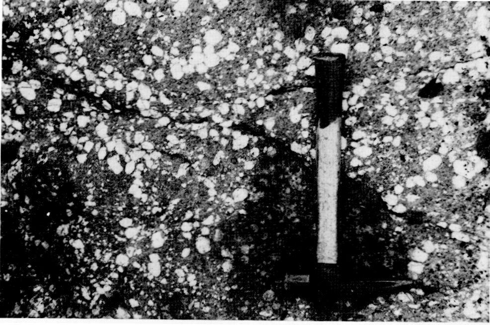
69

70

71
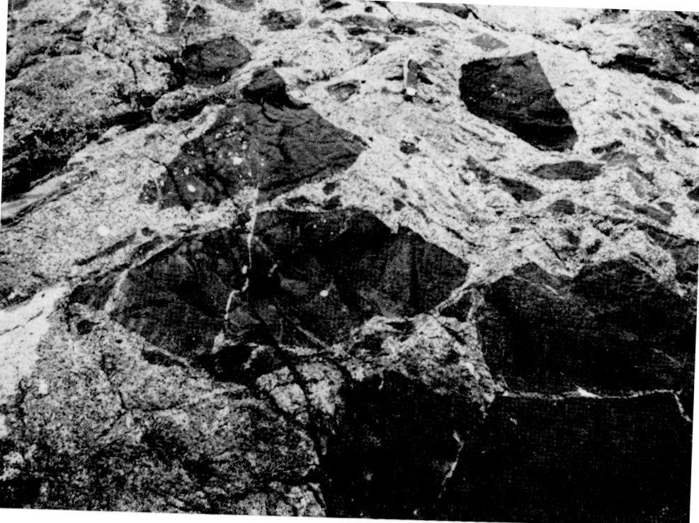
72

73

74 . "5*:

75

76

77

78 Map 2273 Atikwa Lake ONTARIO DIVISION OF MINES HONOURABLE LEO BERNIER, Minister of Natural Resources W. Q. MACNEE, Deputy Minister of Natural Resources G. A. Jewett, Executive Director, Division of Mines E. G. Pye, Director, Geological Branch Scale, l inch to 50 miles. N.T.S. Reference 52 F/5 LEGEND CENOZOIC* QUATERNARY RECENT Swamp and stream deposits. PLEISTOCENE Sand, gravel, clay. UNCONFORMITY:, PRECAMBRIAN6 EARLY PRECAMBRIAN (ARCHEAN) FELSIC TO INTERMEDIATE INTRUSIVE ROCKS SYMBOLS j^ INTRUSIVE CONTACT - Small bedrock outcrop. "~\ r ^ /* 5 5a Area of bedrock outcrop. 5b 5c 5d 5e 5f 5g Bedding, top unknown; (inclined, ver tical). X soy 6a Medium-grained pink. granite.c 6b Pegmatite, granite, aplite (dikes). Glacial striae. Bedding, top (arrow) from grain grada tion; (inclined, vertical, overturned). X^O" 4 -S- -f V Lava flow; top (arrow) from pillows shape and packing. 65//.^ t Schistosity; (horizontal, inclined, ver tical). 4b Gneissosity, (horizontal, inclined, ver tical). 4d 4e 3Si/ V 4a 4c Lineation with plunge. -^ ^ MAFICTO ULTRAMAFIC INTRUSIVE ROCKS 3 Geological boundary, observed. 3a,"'" Geological boundary, position inter preted. ^, ** ""i ^~~ --^ ^ A a 298 ' 3b 3c Fault; (observed, assumed). Spot indi cates down throw side, arrows indicate horizontal movement. 3d INTRUSIVE CONTACT Lineament. METAVOLCANICS AND METASEDIMENTS METASEDIMENTS Anticline, syncline, with plunge. 2a Arkose, quartzite. 2b Greywacke, slate, derived schists. 2c Conglomerate, probably intraforma tional. METAVOLCANICS / Unsubdivided metavolcanics. 1a Basaltic and andesine flows. Ib Porphyritic basalt. 1c Mafic tuff, lapilli tuff, agglomerate, breccia. 1d Sheared mafic to intermediate vol canic rocks. 1e Basalt and brecciated basalt; inti mately injected by diorite. Grades into 4b. 1g Intermediate and felsic flows; tuff and agglomerate. 1h Coarse-grained mafic flows; may be intrusive in part, 1j Pillowed basaltic and andesilic flows. Magnetic attraction, u Muskeg or swamp. Motor road. Other road. Trail, portage, winter road.. Building. ixiw^ Baseline with mi/epost, approximate lo cation only. Surveyed line,approximate location only. Property boundary, approximate location only. 8 Unsubdivided mafic to ultramafic in trusive rocks. Coarse-grained gabbro or metagabbro. Medium-grained gabbro or metagabbro. Gabbro with rounded amphiboles; may be coarse-grained basalt in part. Peridotite, pyroxenite. 3e Porphyritic anorthosite gabbro. Shaft; depth in feet. MA,- Unsubdivided intermediate intrusive rocks. Biotite-hornblende diorite, quartz diorite, d Medium-grained diorite with abun dant dark volcanic inclusions. Medium-grained diorite with gabbro inclusions. Monzodiorite. 0 Feldspar porphyry (dikes). INTRUSIVE CONTACT 3S" X s" Unsubdivided felsic to intermediate intrusive rocks. Quartz diorite, trondhjemite, grano diorite,d Quartz-rich quartz diorite. Quartz diorite with mafic inclusions. Coarse-grained granodiorite. Medium-grained granodiorite. Monzonite. 0 Quartz porphyry, quartz-feldspar porphyry. Ag Au Silver. Gold. Cu Ni Copper. Nickel. S Sulphide mineralization. 'Unconsolidated deposits. Cenozoic deposits are rep resented by the lighter coloured parts of the map. Location of mining property or occur rence, (surveyed, unsurveyed). See list of properties. "Bedrock geology. Outcrops and inferred extensions of each rock map-unit are shown respectively, in deep and light tones of the same colour. Where in places a formation is too narrow to show colour and must be represented in black, a short black bar appears in the appropriate block. cunits of the Flora Lake Stock. dsome rocks mapped as 5a may be equivalent to those mapped as 4a, and vice versa. LIST OF PROPER/TIES 1. Apex occurrence Cameron M. Y. [c. 1900} Caviar Lake occurrence. Chipman Lake Mines Ltd. Denlake Mining Company Ltd. [1952] Edlon Mines Ltd. Falconbridge Nickel Mines Ltd. [1957] Falconbridge Nickel Mines Ltd. Falconbridge Nickel Mines Ltd. [1956] Green Bay prospect. Hotstone Minerals Ltd. International Nickel Company of Canada Ltd. (The) ] SOURCES OF INFORMATION Geology by J. C. Davies and assistants, Geology is not tied to surveyed lines. Assessment work data on file with the Ministry of Natural Resources. 13. Kenbridge Nickel Mines Ltd, O.D.M.-G.S.C. Aeromagnetic map 1169G. 14. Maybrun Mines Ltd. 15. Nic-Cop Mines Ltd. [1957] 16. Wilson B.F. Gauthier A. Preliminary Maps: P. 387, Atikwa Lake Area (West half); P. 388, Atikwa Lake Area (East half)-scale 1 inch to Yi mile, issued in Nina prospect. 18. Noranda occurrence. 19. Shawkey occurrence. 20. Tillie Lake portage ] Basemaps derived from maps of the Forest Resources Inventory, Ministry of Natural Resources, with addi tional information by J. C. Davies. 21. Tundra Gold Mines Ltd. 22. Virginia mine. 23. Wright-Hargreaves occurrence. Cartography by C. C. Cashin and assistants, Ministry of Natural Resources, Date in square brackets [1956] indicates year of last major work on property. For further information, see report. Magnetic declination in the area was approximately 6"E in Map 2273 ATIKWA LAKE KENORA DISTRICT " - ; f Scale 1:31,680 or l Inch to 1A Mile Metres 1000 Feet O 5,000 10,000 Feet Kilometres
GEOLOGY OF THE NICOLA GROUP BETWEEN MISSEZULA LAKE AND ALLISON LAKE
 GEOLOGY OF THE NICOLA GROUP BETWEEN MISSEZULA LAKE AND ALLISON LAKE (92H/15E. 10E1 By V. A. Preto INTRODUCTION Mapping was continued southward from the area covered in 1973 and an additional 55 square
This work follows the international standard nomenclature (IUGS) in naming the
 in naming the") CHAPTER FIVE: PETROGRAPHY This work follows the international standard nomenclature (IUGS) in naming the different Platreef rock types. It should be noted that new lithologies not described in chapter
CHAPTER FIVE: PETROGRAPHY This work follows the international standard nomenclature (IUGS) in naming the different Platreef rock types. It should be noted that new lithologies not described in chapter
AGGREGATE RESOURCES OF ONTARIO (ARO) METADATA
 METADATA") AGGREGATE RESOURCES OF ONTARIO (ARO) METADATA GENERAL INFORMATION Official Name of the Data Set or Information Holding: Aggregate Resources of Ontario Acronyms are Used to Identify the Data Set or Information
AGGREGATE RESOURCES OF ONTARIO (ARO) METADATA GENERAL INFORMATION Official Name of the Data Set or Information Holding: Aggregate Resources of Ontario Acronyms are Used to Identify the Data Set or Information
THESE TERMS GOVERN YOUR USE OF THIS DOCUMENT
 THESE TERMS GOVERN YOUR USE OF THIS DOCUMENT Your use of this Ontario Geological Survey document (the Content ) is governed by the terms set out on this page ( Terms of Use ). By downloading this Content,
THESE TERMS GOVERN YOUR USE OF THIS DOCUMENT
 THESE TERMS GOVERN YOUR USE OF THIS DOCUMENT Your use of this Ontario Geological Survey document (the Content ) is governed by the terms set out on this page ( Terms of Use ). By downloading this Content,
Appendix 11. Geology. of the. I60 area
 Appendix 11 Geology of the I60 area 1. Locality The locality of the I60 area is as follows; Northwestern corner; UTM_EW 530513, UTM_NS 7345741 Southwestern corner; UTM_EW 530418, UTM_NS 7301454 Northeastern
Mishi Lake Gold Property Mishibishu Lake Area, Wawa
 Mishi Lake Gold Property Mishibishu Lake Area, Wawa Location, Accessibility, Infrastructure and Local Resources The property is located 40 km west of Wawa, Ontario, in the Mishibishu Lake Area, Sault Ste.
Local: (705) Toll Free: , ext (inside Canada, United States) Local: (705) Toll Free: , ext.
 Toll Free: , ext (inside Canada, United States) Local: (705) Toll Free: , ext.") THESE TERMS GOVERN YOUR USE OF THIS DOCUMENT Your use of this Ontario Geological Survey document (the Content ) is governed by the terms set out on this page ( Terms of Use ). By downloading this Content,
THESE TERMS GOVERN YOUR USE OF THIS DOCUMENT Your use of this Ontario Geological Survey document (the Content ) is governed by the terms set out on this page ( Terms of Use ). By downloading this Content,
MRD283-REV METADATA. Acronyms are Used to Identify the Data Set or Information Holding: MRD283-REV
 MRD283-REV METADATA GENERAL INFORMATION Official Name of the Data Set or Information Holding: Ambient Groundwater Geochemistry Data for Southern Ontario, 2007 2014 Acronyms are Used to Identify the Data
=%REPORT RECONNAISSANCE OF CHISHOLM LAKE PROSPECT. October 25, 1977
 =%REPORT ON FIELD RECONNAISSANCE OF CHISHOLM LAKE PROSPECT October 25, 1977 Bruce D. Vincent Imperial Oil Limited, Minerals - Coal, CALGARY, ALBERTA CHISHOLM LAKE PROSPECT Introduction The Chisholm Lake
THESE TERMS GOVERN YOUR USE OF THIS DOCUMENT
 THESE TERMS GOVERN YOUR USE OF THIS DOCUMENT Your use of this Ontario Geological Survey document (the Content ) is governed by the terms set out on this page ( Terms of Use ). By downloading this Content,
Local: (705) Toll Free: , ext (inside Canada, United States) Local: (705) Toll Free: , ext.
 Toll Free: , ext (inside Canada, United States) Local: (705) Toll Free: , ext.") THESE TERMS GOVERN YOUR USE OF THIS DOCUMENT Your use of this Ontario Geological Survey document (the Content ) is governed by the terms set out on this page ( Terms of Use ). By downloading this Content,
THESE TERMS GOVERN YOUR USE OF THIS DOCUMENT Your use of this Ontario Geological Survey document (the Content ) is governed by the terms set out on this page ( Terms of Use ). By downloading this Content,
Block: Igneous Rocks. From this list, select the terms which answer the following questions.
 Geology 12 Name: Mix and Match: Igneous Rocks Refer to the following list. Block: porphyritic volatiles mafic glassy magma mixing concordant discontinuous reaction series igneous vesicular partial melting
The Cobalt Rainbow. Airborne geophysical maps show that a north trending aeromagnetic high suggests further undiscovered mineralisation.
 The Cobalt Rainbow The property is located on Greenstone Creek, approximately 4.8 kilometres south west of the creek mouth. The property is located about 24 km due west of Campbell River, in the east-central
MRD273-REV METADATA. Acronyms are Used to Identify the Data Set or Information Holding: MRD273-REV
 MRD273-REV METADATA GENERAL INFORMATION Official Name of the Data Set or Information Holding: Ontario Precambrian Bedrock Magnetic Susceptibility Geodatabase for 2001 to 2012 Acronyms are Used to Identify
Chapter 10. Chapter Rocks and the Rock Cycle. Rocks. Section 1 Rocks and the Rock Cycle
 Chapter 10 Rocks 1 Chapter 10 Section 1 Rocks and the Rock Cycle 2 10.1 Rocks and the Rock Cycle Magma is the parent material for all rocks. Once the magma cools and hardens, many changes can occur. Geology:
Nickel Division - Sudbury Operations
 * *-.. FALCONBRIDGE NICKEL MINES LIMITED Nickel Division - Sudbury Operations Falconbridge, Ontario 002261 GRAHAM 010 GEOLOGY OF TllE NORTH QUARTER OP LOT 2, CON. IV, GRAHAM TOWNSHIP, DISTRICT OP SUDBURY,
MRD 281. Official Name of the Data Set or Information Holding: Northeastern Ontario Rhyolite Database
 MRD 281 GENERAL INFORMATION Official Name of the Data Set or Information Holding: Northeastern Ontario Rhyolite Database Acronyms are Used to Identify the Data Set or Information Holding: MRD281 Describe
THESE TERMS GOVERN YOUR USE OF THIS DOCUMENT
 THESE TERMS GOVERN YOUR USE OF THIS DOCUMENT Your use of this Ontario Geological Survey document (the Content ) is governed by the terms set out on this page ( Terms of Use ). By downloading this Content,
MRD 207 METADATA DETAIL PAGE
 MRD 207 METADATA DETAIL PAGE The following represents the Basic description of an information holding. To obtain more information about this holding, see the section named Contacts. GENERAL INFORMATION
The MAPLE BAY PROJECT Copper Silver - Gold
 The MAPLE BAY PROJECT Copper Silver - Gold Good grade and tonnage potential within close proximity to Tidewater The Maple Bay Copper Silver Gold Project covers highly favourable geological host rocks of
DISCOVERY OF MINERALISED PORPHYRY & MAGNETITE-COPPER-GOLD AT KAMARANGAN
 MEDUSA MINING LIMITED ABN: 60 099 377 849 Unit 7, 11 Preston Street Como WA 6152 PO Box 860 Canning Bridge WA 6153 Telephone: +618-9367 0601 Facsimile: +618-9367 0602 Email: admin@medusamining.com.au Internet:
THESE TERMS GOVERN YOUR USE OF THIS DOCUMENT
 THESE TERMS GOVERN YOUR USE OF THIS DOCUMENT Your use of this Ontario Geological Survey document (the Content ) is governed by the terms set out on this page ( Terms of Use ). By downloading this Content,
Drill locations for the 2015 program are highlighted in the geology map below.
 2015 Exploration Program The exploration program plan at KSM for 2015 was designed to improve the understanding of block cave targets and support engineering/environmental aspects of development scenarios.
We are committed to providing accessible customer service. If you need accessible formats or communications supports, please contact us.
 We are committed to providing accessible customer service. If you need accessible formats or communications supports, please contact us. Nous tenons à améliorer l accessibilité des services à la clientèle.
THESE TERMS GOVERN YOUR USE OF THIS DOCUMENT
 THESE TERMS GOVERN YOUR USE OF THIS DOCUMENT Your use of this Ontario Geological Survey document (the Content ) is governed by the terms set out on this page ( Terms of Use ). By downloading this Content,
We are committed to providing accessible customer service. If you need accessible formats or communications supports, please contact us.
 We are committed to providing accessible customer service. If you need accessible formats or communications supports, please contact us. Nous tenons à améliorer l accessibilité des services à la clientèle.
NEW HAZELTON, OMINECA M.D.,
 PROSPECTING REPORT JUDI 1 TO 6 MINERAL CLAIMS NEW HAZELTON, OMINECA M.D., B.C. MAP 93M/4E, LAT. SS014'N, LONG. 127'33'W OWNED BY: A. L'ORSA ANTHONY L'ORSA Smithers, B.C. 21 February, 1981 TABLE OF CONTENTS
THESE TERMS GOVERN YOUR USE OF THIS DOCUMENT
 THESE TERMS GOVERN YOUR USE OF THIS DOCUMENT Your use of this Ontario Geological Survey document (the Content ) is governed by the terms set out on this page ( Terms of Use ). By downloading this Content,
GEOPHYSICAL DATA SET (GDS) 1084B METADATA
 1084B METADATA") GEOPHYSICAL DATA SET (GDS) 1084B METADATA GENERAL INFORMATION Official Name of the Data Set or Information Holding: Ontario Airborne Geophysical Surveys, Magnetic Gradiometer and Gamma-Ray Spectrometric
GEOPHYSICAL DATA SET (GDS) 1084B METADATA GENERAL INFORMATION Official Name of the Data Set or Information Holding: Ontario Airborne Geophysical Surveys, Magnetic Gradiometer and Gamma-Ray Spectrometric
3. GEOLOGY. 3.1 Introduction. 3.2 Results and Discussion Regional Geology Surficial Geology Mine Study Area
 3. GEOLOGY 3.1 Introduction This chapter discusses the baseline study of the geology and mineralization characteristics of the mine study area. The study consolidates existing geological data and exploration
Practice Test Rocks and Minerals. Name. Page 1
 Name Practice Test Rocks and Minerals 1. Which rock would be the best source of the mineral garnet? A) basalt B) limestone C) schist D) slate 2. Which mineral is mined for its iron content? A) hematite
As compaction and cementation of these sediments eventually occur, which area will become siltstone? A) A B) B C) C D) D
 A B) B C) C D) D") 1. A student obtains a cup of quartz sand from a beach. A saltwater solution is poured into the sand and allowed to evaporate. The mineral residue from the saltwater solution cements the sand grains together,
1. A student obtains a cup of quartz sand from a beach. A saltwater solution is poured into the sand and allowed to evaporate. The mineral residue from the saltwater solution cements the sand grains together,
 UNIT-3 PETROLOGY QUESTIONS AND ANSWERS 1. What is mean by Rock? It is defined as natural solid massive aggregates of minerals forming the crust of the earth 2. Define Petrology? The branch of geology dealing
GEOLOGICAL INVESTIGATION IN THE ISLAND LAKE GREENSTONE BELT, NORTHWESTERN SUPERIOR PROVINCE, MANITOBA (PARTS OF NTS 53E/15 & 16) GS-18
 GS-18") GS-18 GEOLOGICAL INVESTIGATION IN THE ISLAND LAKE GREENSTONE BELT, NORTHWESTERN SUPERIOR PROVINCE, MANITOBA (PARTS OF NTS 53E/15 & 16) by S. Lin, H.D.M. Cameron, E.C. Syme and F. Corfu 1 Lin, S., Cameron,
GS-18 GEOLOGICAL INVESTIGATION IN THE ISLAND LAKE GREENSTONE BELT, NORTHWESTERN SUPERIOR PROVINCE, MANITOBA (PARTS OF NTS 53E/15 & 16) by S. Lin, H.D.M. Cameron, E.C. Syme and F. Corfu 1 Lin, S., Cameron,
NOA ASSESSMENT HARRIS QUARRY MENDOCINO COUNTY, CALIFORNIA TABLE OF CONTENTS
 NOA ASSESSMENT HARRIS QUARRY MENDOCINO COUNTY, CALIFORNIA TABLE OF CONTENTS Introduction... 1 Scope of Services... 1 Project Location and Description... 1 Geologic Setting... 1 Regional Geology... 1 Site
MRD 228 METADATA. Official Name of the Data Set or Information Holding: Physiography of Southern Ontario
 MRD 228 METADATA GENERAL INFORMATION Official Name of the Data Set or Information Holding: Physiography of Southern Ontario Acronyms are Used to Identify the Data Set or Information Holding: MRD228 Describe
Local: (705) Toll Free: , ext (inside Canada, United States) Local: (705) Toll Free: , ext.
 Toll Free: , ext (inside Canada, United States) Local: (705) Toll Free: , ext.") THESE TERMS GOVERN YOUR USE OF THIS DOCUMENT Your use of this Ontario Geological Survey document (the Content ) is governed by the terms set out on this page ( Terms of Use ). By downloading this Content,
THESE TERMS GOVERN YOUR USE OF THIS DOCUMENT Your use of this Ontario Geological Survey document (the Content ) is governed by the terms set out on this page ( Terms of Use ). By downloading this Content,
Introducti on. Land Survey. Geomagnetic Survey. Geomagnetic Results and Interpretati ons - Conclusions and Recommendations C
 m M 42A86SW8281 63.42 PRICE 010 C O H T E H l 42A86SW828I 63.42 PRICE 010C Introducti on Land Survey Geomagnetic Survey Geomagnetic Results and Interpretati ons - Conclusions and Recommendations - - -
MRD 229-Revised METADATA
 GENERAL INFORMATION MRD 229-Revised METADATA Official Name of the Data Set or Information Holding: Till Compositional Database: Investigation of the Overburden Signature of the Caribou Lake Greenstone
Prospecting Report 'S Office i DB Property, B.C. -J Negro Creek Nelson Mining District NTS 82F.050. Operator: Kootenay Gold Inc.
 . '.' I"' i9 12 Prospecting Report 'S Office i DB Property, B.C. -J Negro Creek Nelson Mining District NTS 82F.050 Operator: Kootenay Gold Inc. Owner: Darlene Lavoie Work Performed Summer of 2007 Report
APPENDIX 2 Table 2. Sample descriptions
 Table 2. descriptions 225 Felsic gneiss, fine-grained and very light-gray. From the upper part of the lower of the two layers, which connect. 226 Amphibolite, even-grained, fine-grained, medium-gray, little
RR#7 - Multiple Choice
 1. Which mineral is mined for its iron content? 1) hematite 2) fluorite 3) galena 4) talc 2. Which rock is composed of the mineral halite that formed when seawater evaporated? 1) limestone 2) dolostone
THESE TERMS GOVERN YOUR USE OF THIS DOCUMENT
 THESE TERMS GOVERN YOUR USE OF THIS DOCUMENT Your use of this Ontario Geological Survey document (the Content ) is governed by the terms set out on this page ( Terms of Use ). By downloading this Content,
Chapter 4 Rocks & Igneous Rocks
 Chapter 4 Rocks & Igneous Rocks Rock Definition A naturally occurring consolidated mixture of one or more minerals e.g, marble, granite, sandstone, limestone Rock Definition Must naturally occur in nature,
GS-17. Summary. Previous work. Regional setting. Introduction. Geology
 GS-17 Geology, structure and mineralization of the Ore Fault property, Bird River greenstone belt, southeastern Manitoba (parts of NTS 52L5NE and 52L6NW) by L.A. Murphy 1 and P. Theyer Murphy, L.A. and
THESE TERMS GOVERN YOUR USE OF THIS DOCUMENT
 THESE TERMS GOVERN YOUR USE OF THIS DOCUMENT Your use of this Ontario Geological Survey document (the Content ) is governed by the terms set out on this page ( Terms of Use ). By downloading this Content,
Local: (705) Toll Free: , ext (inside Canada, United States) Local: (705) Toll Free: , ext.
 Toll Free: , ext (inside Canada, United States) Local: (705) Toll Free: , ext.") THESE TERMS GOVERN YOUR USE OF THIS DOCUMENT Your use of this Ontario Geological Survey document (the Content ) is governed by the terms set out on this page ( Terms of Use ). By downloading this Content,
THESE TERMS GOVERN YOUR USE OF THIS DOCUMENT Your use of this Ontario Geological Survey document (the Content ) is governed by the terms set out on this page ( Terms of Use ). By downloading this Content,
GEOLOGICAL MAPPING OF SKARNS ON THE SHEEP AND EWE CLAIMS, TURNAGAIN RIVER, B.C. DURING THE 1979 SUMMER SEASON
 GEOLOGICAL MAPPING OF SKARNS ON THE SHEEP AND EWE CLAIMS, TURNAGAIN RIVER, B.C. DURING THE 1979 SUMMER SEASON CLAIMS: Sheep 1 to 4 Ewe 1, 3, 4 to 8 Lamb 12 Fraction Liard Mining Division, B.C. NTS 104
CHAPTER 3.3: METAMORPHIC ROCKS
 CHAPTER 3.3: METAMORPHIC ROCKS Introduction Metamorphism - the process of changes in texture and mineralogy of pre-existing rock due to changes in temperature and/or pressure. Metamorphic means change
THESE TERMS GOVERN YOUR USE OF THIS DOCUMENT
 THESE TERMS GOVERN YOUR USE OF THIS DOCUMENT Your use of this Ontario Geological Survey document (the Content ) is governed by the terms set out on this page ( Terms of Use ). By downloading this Content,
Igneous petrology EOSC 321
 Igneous petrology EOSC 321 Laboratory 2: Determination of plagioclase composition. Mafic and intermediate plutonic rocks Learning Goals. After this Lab, you should be able: Determine plagioclase composition
INTRODUCTION REGIONAL GEOLOGY. N. St-Jean 1, L. Hunt 1 and R.L. Sherlock 1
 37. Preliminary Results from Mapping a New Exposure of the Basal Unconformity Between the Hearst and Larder Lake Assemblages, Skead Township, Northeastern Ontario N. St-Jean 1, L. Hunt 1 and R.L. Sherlock
VECTORING VOLCANOGENIC MASSIVE SULPHIDE MINERALIZATION AT THE RAINDROP ZONE, SNOW LAKE (NTS 63K16), MANITOBA by G.H. Gale
, MANITOBA by G.H. Gale") GS-8 VECTORING VOLCANOGENIC MASSIVE SULPHIDE MINERALIZATION AT THE RAINDROP ZONE, SNOW LAKE (NTS 63K16), MANITOBA by G.H. Gale Gale, G.H. 2002: Vectoring volcanogenic massive sulphide mineralization at
GS-8 VECTORING VOLCANOGENIC MASSIVE SULPHIDE MINERALIZATION AT THE RAINDROP ZONE, SNOW LAKE (NTS 63K16), MANITOBA by G.H. Gale Gale, G.H. 2002: Vectoring volcanogenic massive sulphide mineralization at
Version 1 Page 1 Barnard/George/Ward
 The Great Mineral & Rock Test 1. Base your answer to the following question on the table below which provides information about the crystal sizes and the mineral compositions of four igneous rocks, A,
Name Class Date. In your textbook, read about the nature of igneous rocks. Use each of the terms below just once to complete the following statements.
 CHAPTER 5 Igneous Rocks SECTION 5.1 What are igneous rocks? In your textbook, read about the nature of igneous rocks. Use each of the terms below just once to complete the following statements. basaltic
40-50 Minutes, 3 minutes per station, 13 Stations, samples provided by UWM and Pierre Couture
 Event: Judge: Rocks & Minerals Pierre couture 40-50 Minutes, 3 minutes per station, 13 Stations, samples provided by UWM and Pierre Couture 1-4 Minerals (50 points total) 5-7 Igneous Rocks (50 points total)
GLY 155 Introduction to Physical Geology, W. Altermann. Grotzinger Jordan. Understanding Earth. Sixth Edition
 Grotzinger Jordan Understanding Earth Sixth Edition Chapter 4: IGNEOUS ROCKS Solids from Melts 2011 by W. H. Freeman and Company Chapter 4: Igneous Rocks: Solids from Melts 1 About Igneous Rocks Igneous
Igneous and Metamorphic Rock Forming Minerals. Department of Geology Mr. Victor Tibane SGM 210_2013
 Igneous and Metamorphic Rock Forming Minerals Department of Geology Mr. Victor Tibane 1 SGM 210_2013 Grotzinger Jordan Understanding Earth Sixth Edition Chapter 4: IGNEOUS ROCKS Solids from Melts 2011
THESE TERMS GOVERN YOUR USE OF THIS DOCUMENT
 THESE TERMS GOVERN YOUR USE OF THIS DOCUMENT Your use of this Ontario Geological Survey document (the Content ) is governed by the terms set out on this page ( Terms of Use ). By downloading this Content,
Notes: Note. Township of GODSON Report NQ: 12. Diamond Dniiing. Hole NQ Footage Date. July/56. July/56. Aug/56. Aug/56. Claim NQ 487' K ' l-a
 Diamond Dniiing S2F«4NW«194 12 GODSON 010 Township of GODSON Report NQ: 12 Work performed by: KENNCO EXPLORATIONS (CANADA) LTD. Claim NQ Hole NQ Footage Date Note K 25434 l 487' July/56 l-a 48' July/56
Chapter - IV PETROGRAPHY. Petrographic studies are an integral part of any structural or petrological studies in
 Chapter - IV PETROGRAPHY 4.1. Introduction Petrographic studies are an integral part of any structural or petrological studies in identifying the mineral assemblages, assigning nomenclature and identifying
Student Name: College: Grade:
 Student Name: College: Grade: Physical Geology Laboratory IGNEOUS MINERALS AND ROCKS IDENTIFICATION - INTRODUCTION & PURPOSE: In this lab you will learn to identify igneous rocks in hand samples from their
LAB 6: TRINIDAD BEACH FIELD TRIP
 OBJECTIVES: LAB 6: TRINIDAD BEACH FIELD TRIP 1) to develop your powers of observation, especially of geological phenomena; 2) to identify the rocks exposed at Trinidad Beach; 3) to reconstruct some of
Geology, Alteration and. Petrogenesis
 The Mutooroo Copper Deposit: Geology, Alteration and Petrogenesis Graham S. Teale Consultant t Andrew T. Price Havilah Resources NL The speaker would like to thank Havilah Resources NL for the opportunity
Queensland Mining Corporation Limited
 Queensland Mining Corporation Limited ABN 61 109 962 469 ASX Release 29 th July 2011 Drilling Commenced at Duck Creek Copper-Gold Project, Cloncurry, North-west Queensland Highlights RC drilling has commenced
1. Base your answer to the following question on on the photographs and news article below. Old Man s Loss Felt in New Hampshire
 UNIT 3 EXAM ROCKS AND MINERALS NAME: BLOCK: DATE: 1. Base your answer to the following question on on the photographs and news article below. Old Man s Loss Felt in New Hampshire FRANCONIA, N.H. Crowds
COPPERSTONE RESOURCES AB INTERCEPTS ZONE OF CHALCOPYRITE-ARSENOPYRITE- BORNITE MINERALIZATION AT SVARTLIDEN IN FIRST DEEP DRILLHOLE FROM 720m-810m
 COPPERSTONE RESOURCES AB INTERCEPTS ZONE OF CHALCOPYRITE-ARSENOPYRITE- BORNITE MINERALIZATION AT SVARTLIDEN IN FIRST DEEP DRILLHOLE FROM 720m-810m In mid-january 2017 Copperstone Resource published a geological
MEMO. TO: Dennis Lapoint CC: FROM: Eriaan Wirosono DATE: April, 20 th 2014 SUBJECT: Exploration activity report March-April 2014_EW
 TO: Dennis Lapoint CC: FROM: Eriaan Wirosono DATE: April, 20 th 2014 SUBJECT: Exploration activity report March-April 2014_EW MEMO 1. Highlights and Productivity Overview pan sampling on target Areas 1
FIRST YEAR ASSESSMENT REPORT PROSPECTING LICENCE 16512M MARYSTOWN AREA, BURIN PENINSULA NTS 1M/3
 FIRST YEAR ASSESSMENT REPORT OF PROSPECTING ON LICENCE 16512M MARYSTOWN AREA, BURIN PENINSULA NTS 1M/3 BY NATHANIEL NOEL MSc. FOR E. MICHELE NOEL MINERAL LICENCES: 16512 M WORK CONDUCTED: MID-SEPTEMBER
4J)SESSMEN'I' REPORT BRANCH. cc" FILE No: ASSESSMENT REPORT VICTORIA MINING DIVISION. Latitude 123O SF' Longitude 48O S5'
SESSMEN'I' REPORT BRANCH. cc FILE No: ASSESSMENT REPORT VICTORIA MINING DIVISION. Latitude 123O SF' Longitude 48O S5'") ASSESSMENT REPORT - ON THE ORM 1 MINERAL CLAIM VICTORIA MINING DIVISION NTS 92B cc" Latitude 123O SF' Longitude 48O S5' 3-2. w N C FILE No: @&@LOGI.CAL BRANCH 4J)SESSMEN'I' REPORT Date : June 1, 1990 TABLE
ASSESSMENT REPORT - ON THE ORM 1 MINERAL CLAIM VICTORIA MINING DIVISION NTS 92B cc" Latitude 123O SF' Longitude 48O S5' 3-2. w N C FILE No: @&@LOGI.CAL BRANCH 4J)SESSMEN'I' REPORT Date : June 1, 1990 TABLE
Igneous Rocks. Sedimentary Rocks. Metamorphic Rocks
 Name: Date: Igneous Rocks Igneous rocks form from the solidification of magma either below (intrusive igneous rocks) or above (extrusive igneous rocks) the Earth s surface. For example, the igneous rock
Topics that will be discussed
 Topics that will be discussed The Rock Cycle Igneous Rock Sedimentary Rock Metamorphic Rock The Rock Cycle -Rocks The parent material for all rocks is MAGMA. What is MAGMA? -Rock forming Minerals Are:
Namex Explorations Inc. Report on Drill Holes PC & PC Post Creek Property Claim S.l , Norman Township Sudbury Mining District
 . 368 4: Namex Explorations nc. Report on Drill Holes PC - 12-06 & PC -- 13-06 Post Creek Property Claim S.l 094826, Norman Township Sudbury Mining District RECEVED DEC 1 0 =:~7 ntroduction GEOSCENCf ASSESSMENT
Marshall Shore Town Park, Liberty, Maine
 Maine Geologic Facts and Localities August, 2005 Marshall Shore Town Park, Liberty, Maine 44 22 33.04 N, 69 21 9.19 W Text by Henry N. Berry IV, Department of Agriculture, Conservation & Forestry 1 Introduction
GEOLOGICAL FEATURES OF THE BADGER SPRINGS TRAIL FOR HIKERS Rev. 3,
 GEOLOGICAL FEATURES OF THE BADGER SPRINGS TRAIL FOR HIKERS Rev. 3, 12-3-02 http://ensayoes.com/docs/176/index-2111121.html Trail location The Badger Springs trail is just a short distance North of the
Which sample best shows the physical properties normally associated with regional metamorphism? (1) A (3) C (2) B (4) D
 A (3) C (2) B (4) D") 1 Compared to felsic igneous rocks, mafic igneous rocks contain greater amounts of (1) white quartz (3) pink feldspar (2) aluminum (4) iron 2 The diagram below shows how a sample of the mineral mica breaks
1 Compared to felsic igneous rocks, mafic igneous rocks contain greater amounts of (1) white quartz (3) pink feldspar (2) aluminum (4) iron 2 The diagram below shows how a sample of the mineral mica breaks
Which rock is shown? A) slate B) dunite C) gneiss D) quartzite
 slate B) dunite C) gneiss D) quartzite") 1. Which metamorphic rock will have visible mica crystals and a foliated texture? A) marble B) quartzite C) schist D) slate 2. The recrystallization of unmelted material under high temperature and pressure
1. Which metamorphic rock will have visible mica crystals and a foliated texture? A) marble B) quartzite C) schist D) slate 2. The recrystallization of unmelted material under high temperature and pressure
Figure GS-25-1: General geology and domain subdivisions in northwestern Superior Province. 155
 GS-25 ASSEAN LAKE ANCIENT CRUST: AN UPDATE by M.T. Corkery, Ch.O. Böhm 1 and L.M Heaman 1 Corkery, M.T., Böhm, Ch.O. and Heaman, L.M. 2000: Assean Lake ancient crust: an update; in Report of Activities
Page 1. Name: 1) Which diagram best shows the grain size of some common sedimentary rocks?
 Which diagram best shows the grain size of some common sedimentary rocks?") Name: 1) Which diagram best shows the grain size of some common sedimentary rocks? 1663-1 - Page 1 5) The flowchart below illustrates the change from melted rock to basalt. 2) Which processes most likely
Name: 1) Which diagram best shows the grain size of some common sedimentary rocks? 1663-1 - Page 1 5) The flowchart below illustrates the change from melted rock to basalt. 2) Which processes most likely
Answers. Rocks. Year 8 Science Chapter 8
 Answers Rocks Year 8 Science Chapter 8 p171 1 Rocks are made up of minerals such as quartz, feldspars, micas, and calcite. Different rocks are made up of different combinations of minerals. 2 Igneous,
Review - Unit 2 - Rocks and Minerals
 Review - Unit 2 - Rocks and Minerals Base your answers to questions 1 and 2 on the diagram below, which shows the results of three different physical tests, A, B, and C, that were performed on a mineral.
2013 GEOLOGICAL ASSESSMENT REPORT SHERIDAN HILL PROPERTY
 2013 GEOLOGICAL ASSESSMENT REPORT ON THE SHERIDAN HILL PROPERTY NEW WESTMINSTER MINING DIVISION BRITISH COLUMBIA NTS 092G07 49 16 31 NORTH LATITUDE, 122 39 48 WEST LONGITUDE PREPARED FOR Sheridan Hill
Geological Studies in the Larsemann Hills, Ingrid Chirstensen Coast, East Antarctica
 363 Twenty Fourth Indian Antarctic Expedition 2003-2005 Ministry of Earth Sciences, Technical Publication No. 22, pp 363-367 Geological Studies in the Larsemann Hills, Ingrid Chirstensen Coast, East Antarctica
SUMMARY REPORT. ESSAR STEEL ALGOMA INC. 105 West Street, Sault Ste. Marie, Ontario, Canada P6A 7B4
 SUMMARY REPORT IRON LAKE PROPERTY Keating and Keating Additional Townships, Ontario, Canada ESSAR STEEL ALGOMA INC. 105 West Street, Sault Ste. Marie, Ontario, Canada P6A 7B4 Date: March 18, 2013 Prepared
Introduction to Prospecting. Session Two Geology
 Introduction to Prospecting Session Two Geology The Earth Earth is 4.6 billion years old (Ba). Bacteria & algae +3.5 Ba. Microscopic animals ~2 Ba. Animals ~600 million years (Ma) old. Mankind about 100,000
Local: (705) Toll Free: , ext (inside Canada, United States) Local: (705) Toll Free: , ext.
 Toll Free: , ext (inside Canada, United States) Local: (705) Toll Free: , ext.") THESE TERMS GOVERN YOUR USE OF THIS DOCUMENT Your use of this Ontario Geological Survey document (the Content ) is governed by the terms set out on this page ( Terms of Use ). By downloading this Content,
THESE TERMS GOVERN YOUR USE OF THIS DOCUMENT Your use of this Ontario Geological Survey document (the Content ) is governed by the terms set out on this page ( Terms of Use ). By downloading this Content,
POTENTIAL OF THE DONGWE COPPER GOLD PROJECT
 POTENTIAL OF THE DONGWE COPPER GOLD PROJECT By Nathan Sabao, P.Geo. September 2015 1 TABLE OF CONTENTS Page 1.0 EXECUTIVE SUMMARY 1 2.0 LOCATION 2 3.0 ACCESS 2 4.0 GEOLOGY 3 5.0 PREVIOUS DRILLING 5 6.0
GEOLOGY OF THAILAND (METAMORPHIC ROCKS)
") GEOLOGY OF THAILAND (METAMORPHIC ROCKS) High-Grade Metamorphic Rocks (Precambrian?) Low-Grade Metamorphic Rocks (Lower Paleozoic) 1 THAILAND EXPLANATION Lower Paleozoic Rocks (Low Grade) Precambrian (?)
GEOLOGY OF THAILAND (METAMORPHIC ROCKS) High-Grade Metamorphic Rocks (Precambrian?) Low-Grade Metamorphic Rocks (Lower Paleozoic) 1 THAILAND EXPLANATION Lower Paleozoic Rocks (Low Grade) Precambrian (?)
EARTH SCIENCE. Geology, the Environment and the Universe. Chapter 5: Igneous Rocks
 EARTH SCIENCE Geology, the Environment and the Universe Chapter 5: Igneous Rocks CHAPTER 5 Igneous Rocks Section 5.1 What are igneous rocks? Section 5.2 Classification of Igneous Rocks Click a hyperlink
Name Petrology Spring 2006
 Igneous rocks lab Part I Due Tuesday 3/7 Igneous rock classification and textures For each of the rocks below, describe the texture, determine whether the rock is plutonic or volcanic, and describe its
THESE TERMS GOVERN YOUR USE OF THIS DOCUMENT
 THESE TERMS GOVERN YOUR USE OF THIS DOCUMENT Your use of this Ontario Geological Survey document (the Content ) is governed by the terms set out on this page ( Terms of Use ). By downloading this Content,
Queenston intersects Contact Zone on the Pandora Property and new gold zones in Kirkland Lake
 1 Queenston intersects Contact Zone on the Pandora Property and new gold zones in Kirkland Lake TORONTO, Ontario, March 7, 2003. Queenston Mining Inc. (QMI-TSX) reports diamond drill results on its 100%
GEOLOGY AND GEOCHRONOLOGY OF THE ISLAND LAKE GREENSTONE BELT, NORTHWESTERN SUPERIOR PROVINCE by J. Parks 1, S. Lin 1, M.T. Corkery and D.W.
 GS-17 GEOLOGY AND GEOCHRONOLOGY OF THE ISLAND LAKE GREENSTONE BELT, NORTHWESTERN SUPERIOR PROVINCE by J. Parks 1, S. Lin 1, M.T. Corkery and D.W. Davis 2 Parks, J., Lin, S., Corkery, M.T. and Davis, D.W.
Pahtavaara Drill Program Intersects 32.8 G/T Gold Over 2.0M And 2.1 G/T Gold Over 18.0M In The Karoliina Zone
 Page 1 of 6 a Pahtavaara Drill Program Intersects 32.8 G/T Gold Over 2.0M And 2.1 G/T Gold Over 18.0M In The Karoliina Zone Jan 11, 2017 Toronto, Ontario, Canada Listed: RUP-TSX-V January 10, 2017 Rupert
PROSPECTING REPORT. Silver Dollar Property. EVENT # TENURE # Tenure Name: GPEX Silver Dollar
 2008-2009 PROSPECTING REPORT Silver Dollar Property EVENT # 4267989 TENURE # 555462 Tenure Name: GPEX Silver Dollar Similkameen Mining Division Map 092H Central Coordinate Reference 120 06 26.9 W Longitude
PROSPECTING REPORT THE WALLACE CLAIM OMENICA MINING DIVISION. 54" x6" 3.d d. for. Reako Exlorat ions Ltd. Wallace Rev. C.G.
 PROSPECTING REPORT ON THE WALLACE CLAIM OMENICA MINING DIVISION 54"44 14 1x6" 3.d d by David A. Howard P.Eng. for Reako Exlorat ions Ltd. Claim Locat ion Wallace Rev. C.G. #1560 Dome Mountain Area 9 3
Pacific Empire Minerals Provides Copper King RC Drilling Results
 Pacific Empire Minerals Provides Copper King RC Drilling Results November 1, 2018 - Vancouver, BC, Canada - Pacific Empire Minerals Corp. (TSXV: PEMC) ( Pacific Empire, PEMC or the Company ), a hybrid