Figure GS-25-1: General geology and domain subdivisions in northwestern Superior Province. 155
|
|
|
- Ethelbert McCarthy
- 5 years ago
- Views:
Transcription

1 GS-25 ASSEAN LAKE ANCIENT CRUST: AN UPDATE by M.T. Corkery, Ch.O. Böhm 1 and L.M Heaman 1 Corkery, M.T., Böhm, Ch.O. and Heaman, L.M. 2000: Assean Lake ancient crust: an update; in Report of Activities 2000, Manitoba Industry, Trade and Mines, Manitoba Geological Survey, p SUMMARY In 1997, the first hints of ancient crust were discovered at Assean Lake in northern Manitoba. This surprising discovery has led to extensive research in the Assean Lake area and the adjacent crustal domains of the Superior Boundary Zone. The Assean Lake ancient crust represents an Archean assembly of crustal segments that trend approximately 090 to 110º and are overprinted by Neoarchean and Paleoproterozoic deformation and metamorphism trending 060. The Assean Lake crustal complex can be subdivided into 1) a southern, migmatitic, supracrustal series of quartz arenite, arkose and metagreywacke gneiss, containing amphibolite and silicate-facies iron-formation, and 2) a central, orthogneiss-dominated crustal segment that intrudes 3) a northern package of supracrustal rocks dominated by mafic to intermediate metavolcanic rocks and greywacke gneiss. Combined Sm-Nd isotopic and U-Pb (by thermal-ionization mass spectometry [TIMS] and sensitive high-resolution ion microprobe [SHRIMP]) geochronological results indicate that Assean Lake preserves Paleoarchean to Mesoarchean crust that underwent a complex and prolonged history spanning more than two billion years. INTRODUCTION This program began in 1995 with the collection of samples in the Split Lake and Nelson River areas for U-Pb geochronology (Heaman 1 Department of Earth and Atmospheric Sciences, University of Alberta, Edmonton, Alberta T6G 2E3 and Corkery, 1996). It led to a detailed (1: scale) mapping project in 1997 at Assean Lake to better understand the Assean Lake deformation zone and the geological nature, kinematics and changes across this presumed Archean Paleoproterozoic boundary (Böhm, 1997). Since 1997, Sm-Nd isotopic studies have been applied in conjunction with integrated mapping and reconnaissance programs on a regional scale. The Sm-Nd isotopic tool has proven to be ideal for discriminating between ancient (i.e. Paleoarchean to Mesoarchean), Neoarchean (i.e. typical Superior Province) and Paleoproterozoic (Trans-Hudson Orogen) crust. Based on the Nd isotope information, key samples were then analyzed by U-Pb dating methods in order to get primary and metamorphic ages. The combination of Nd isotope and U-Pb geochronological data has been instrumental in leading us to propose a new geological configuration of the craton margin, as indicated in Figure GS-25-1 and discussed in Böhm et al. (2000b). One of the most exciting results from this project so far is the identification of an assemblage of rocks in the Assean Lake area, previously mapped as Proterozoic, that is now known to be Mesoarchean (Böhm et al., 2000a). Evidence for ancient (pre-3.5 Ga) crust has provided enormous excitement for the possible preservation of some of the oldest rocks on Earth at Assean Lake. In addition, the re-interpretation of these rocks opens up potential for new mineral-exploration targets in this region. The aim of this report is to focus on recent field work that provides an update on the component rock types, structural relationships and mineral potential of the ancient crust at Assean Lake. Together with Figure GS-25-1: General geology and domain subdivisions in northwestern Superior Province. 155

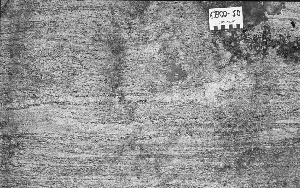
2 geochemical, isotope and geochronological results, these new field observations should contribute to a better understanding of the nature and evolution of the Assean Lake ancient crust, and thus provide new insights into the early crustal evolution of the Earth. GEOLOGY OF THE ASSEAN LAKE AREA The more than 120 km 2 of ancient crust exposed at Assean Lake represents an Archean assembly of crustal segments that trend approximately 090 to 110º and are overprinted by Neoarchean and Paleoproterozoic deformation and metamorphism trending 060º (Fig. GS-25-2). The Assean Lake crustal complex can be subdivided into 1) the Clay River paragneiss, a southern, migmatitic, supracrustal series of quartz arenite, arkose and metagreywacke gneiss, containing amphibolite and silicate-facies iron-formation, and 2) a central orthogneissdominated crustal segment intruding 3) the Lindal Bay paragneiss, a northern package of supracrustal rocks dominated by mafic to intermediate metavolcanic rocks and greywacke gneiss. Clay River Paragneiss and Related Intrusive Rocks At the west end of Assean Lake, north of the main Assean Lake deformation zone, outcrop is dominated by paragneiss with subordinate orthogneiss (Fig. GS-25-2). Two colour varieties of paragneiss occur in this region (pink and grey). The high degree of recrystallization, mobilization and melt injection in the pink gneiss generally masks its probable sedimentary origin (i.e. derived from arkosic sedimentary rocks). Only the garnetiferous, greywacke-derived, grey gneiss is recognized as having a sedimentary origin. In addition, the paucity of outcrop and strong east-northeast-trending structural overprint associated with the Assean Lake Shear Zone preclude definition of mappable stratigraphy. Nevertheless, four distinct units can be described from this southern, migmatitic, supracrustal series. The core of the Clay River paragneiss is a cordierite-sillimanitegarnet bearing biotite metatexite (Fig. GS-25-3a). This migmatitic greywacke gneiss is interpreted to represent a sequence of thickly bedded, psammitic to semipelitic greywacke, most likely formed by density flows. Outcrops show 5 to 15% in situ mobilizate and minor associated garnetiferous pegmatitic injection. The Clay River metagreywacke is associated, on both the north and south sides, with a 5 to 10 m thick sequence of amphibolite. Decametre-scale layered amphibolite varies from massive, coarse grained, salt-and-pepper textured, hornblendeplagioclase amphibolite (Fig. GS-25-3b) to layered hornblende-diopside amphibolite interlayered with pelitic greywacke gneiss. To the north and south of the amphibolite is a K-feldspar- and magnetite-bearing arkosic metatexite (Fig. GS-25-3c) that is strongly recrystallized and contains up to 25% mobilizate and injected granodioritic lits. This arkosic gneiss has previously been mapped as Sickle Formation (Lenton and Corkery, 1981). The compositional layering and interlayering with amphibolite of the Clay River paragneiss series are interpreted as being the result of primary sedimentary layering, migmatization and injection phases. White-weathering, feldspathic biotite gneiss forms the southern and northern unit of the Clay River paragneiss (one outcrop displays a vague hint of trough cross-bedding). These gneissic units are highly variable in quartz content and probably represent quartz arenite composition in some layers (Fig. GS-25-3d). Central Orthogneiss-Dominated Segment The area north of the Clay River paragneiss series is dominated by a sequence of mainly 3.2 Ga tonalite to granodiorite intrusions and derived gneissic rocks. Similar to the Clay River paragneiss, the central orthogneiss underwent migmatization and was injected by later pegmatitic melt phases, resulting in variably layered orthogneiss (Fig. Figure GS-25-2: General geology of the Assean Lake area. 156

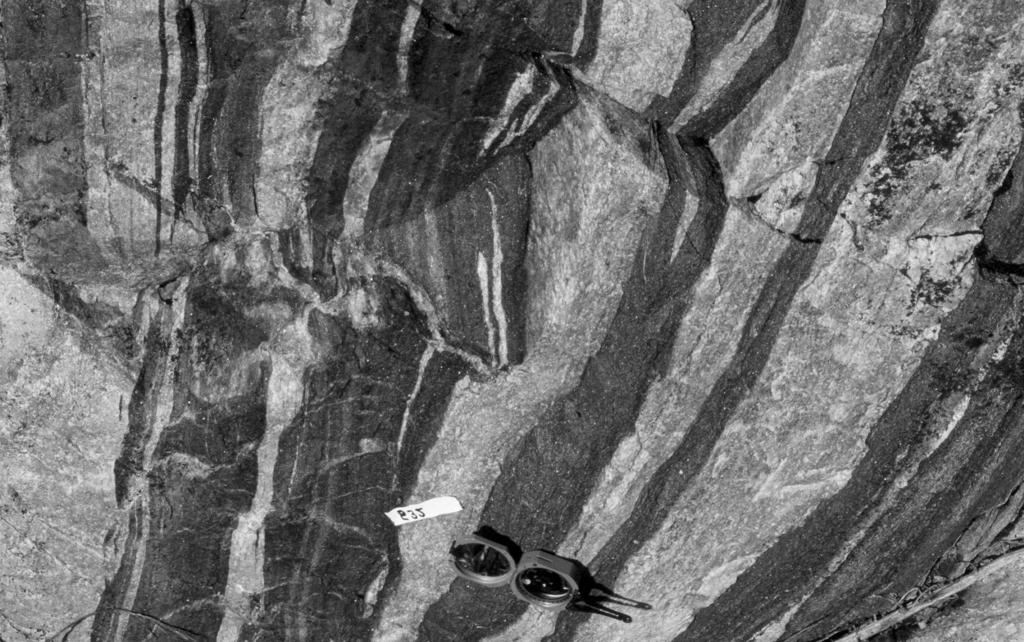
3 a) Figure GS-25-3: Clay River metasedimentary rocks: a) cordierite-sillimanite-garnet bearing greywacke migmatite, b) amphibolite, c) arkosic diatexite, d) arenite and quartz arenite. b) c) d) 157


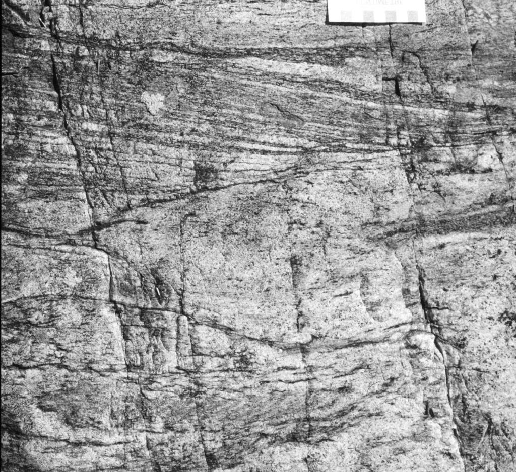
4 GS-25-4a, -4b). Larger, metre-scale, homogeneous pegmatite bodies seem to be directly related to pegmatite injection in the migmatitic orthogneiss. Relict lenses of paragneiss and minor interlayered amphibolite indicate that the central orthogneiss intruded an older supracrustal sequence. Centimetre- to decimetre-scale paragneiss lenses are generally fine-grained, garnet-bearing biotite gneiss. Detailed geochemical analysis of amphibolite samples is in progress and should address the question of whether these mafic lenses and layers represent relicts of early mafic dykes or form part of a supracrustal sequence that includes the above biotite gneiss. Lindal Bay Supracrustal Sequence and Younger Intrusive Rocks In the Lindal Bay area of northeastern Assean Lake, a package of supracrustal rocks dominated by mafic to intermediate metavolcanic rocks and subordinate metasedimentary rocks has been identified (Fig. GS-25-2). As in the Clay River area, a number of rock units can be defined, but stratigraphic relationships are difficult to determine due to the complex structural overprints and lack of continuous outcrop. On the north shore of Lindal Bay, a sequence of rock units trending 090 to 110 is dominated by amphibolite, derived from mafic volcanic rocks, and associated gabbro sills with subordinate greywacke sedimentary rocks (Fig. GS-25-2). Near the contact with the central orthogneiss sequence to the southwest, granodiorite gneiss forms discrete layers in the supracrustal rocks, but contact relationships are overprinted. On the south shore of Lindal Bay, metasedimentary rocks dominate, with subordinate amphibolite, derived from mafic and ultramafic volcanic rocks, along the northwest margin. Rock units in this area are strongly re-oriented by the east-northeast-trending deformation zones. The mafic volcanic rocks are generally highly deformed and vary from fine- to medium-grained, massive to centimetre-scale layered, hornblende-plagioclase amphibolite. In several locations, however, the layering can be recognized as remnants of pillow selvages (Fig. GS-25-5a). These rocks are predominantly basaltic in composition, with subordinate andesitic and ultramafic rocks. The ultramafic rocks occur as isolated outcrops with intrusive textures, and their age relationship to the paragneiss sequence is uncertain. Metasedimentary units are generally thinly bedded and include quartz arenite, silicate-facies iron-formation, layered amphibolite, and mafic lithic and psammitic greywacke (Fig. GS-25-5b). Outcrops are generally small and most are dominated by one rock type. Stratigraphic relationships can only be observed in a few locations. At one location, quartz arenite grades into a garnetiferous plagioclase gneiss and then into thinly bedded, chert-anthophyllite-silicate iron-formation (Fig. GS-25-5c). The amphibole-rich layers become more abundant and the chert layers decrease, over a distance of 30 cm, into staurolite- and amphibole-bearing mafic pelite. This sequence then grades into thinly a) Figure GS-25-4: Central orthogneiss from the north shore of Assean Lake: a) hornblende-biotite granodiorite gneiss with pegmatitic melt injection, b) hornblende tonalite intruded by straight-walled pegmatite. b) 158
 highly")


5 a) Figure GS-25-5: Lindal Bay supracrustal rocks: a) highly strained pillowed basalt, b) staurolite-bearing pelitic metagreywacke, c) silicate-facies iron-formation. b) c) 159
6 layered staurolite- and biotite-bearing pelitic greywacke. Segments of this stratigraphy are observed on numerous outcrops on the peninsula between Lindal Bay and southeastern Assean Lake, but a sedimentary stratigraphy has not been determined. The contact relationships between the volcanic and sedimentary sequences are also unclear. However, both rock units seem to be intruded by later granodiorite to granite and pegmatite. ECONOMIC CONSIDERATIONS The Assean Lake area was found to have gold potential in the late 1930s (Lindal and Dunbrak veins), and a massive sulphide body was drilled in the 1960s. Lead has been known on Galena island since the early 1960s as well. Geological findings of this study may both explain and enhance the economic potential of the area. The Mesoarchean assemblage has the elements of a rift sequence, not unlike the Thompson Nickel Belt except in age. The recognition of zinc-lead showings in highly strained orthogneiss has until now been at most a curiosity. However, the recognition that the gneiss represents a paragneiss sequence may indicate that SEDEX-type deposits could occur in the area, as well as shear-hosted gold and nickel deposits. The occurrence of thick ancient crust in this region may also provide a potential area for diamond-bearing kimberlite pipes. DISCUSSION Integrated mapping and geochemical, Sm-Nd isotopic and U-Pb geochronological studies across the northwestern Superior craton margin over the past five years have resulted in a re-interpretation of the location and nature of the boundary zone between Archean rocks of the Superior Province and Paleoproterozoic rocks of the Trans-Hudson Orogen in the region northeast of Thompson. Based on the discovery of ancient (pre-3.5 Ga) crust at Assean Lake, our research in this area has been intensified and continues to reveal surprising results. The mapping and sampling program during the 2000 field season was designed to document and better define the nature of the rock types that form part of the Assean Lake ancient crustal complex. The 2000 fieldwork identified three crustal assemblages as described above. Samples were collected from all major rock units for further geochemical, isotopic and geochronological studies. Highlights of the 2000 field program include the identification of two distinct supracrustal packages, separated by an orthogneiss-dominated central sequence. Within the supracrustal sequences, silicate-facies iron-formation and metabasalt flows provide critical stratigraphic horizons with which to trace the structurally complex and incomplete stratigraphic assemblies. Unravelling the nature and history of a complex high-grade terrain such as the Assean Lake ancient crust requires a combination of detailed mapping, and isotope and geochronological tools. In addition to the continuous fruitful collaboration between researchers at the University of Alberta and the Manitoba Geological Survey, this project will benefit from collaboration with R. Stern, who is in charge of the sensitive high-resolution ion microprobe (SHRIMP) laboratory at the Geological Survey of Canada in Ottawa. For example, the first ion microprobe U-Pb age results from the Assean Lake ancient crust confirm the existence of crustal components as old as 3.9 Ga preserved in metagreywacke detritus. Considering the size, complexity and heterogeneity of the Assean Lake ancient crust, this area clearly holds enormous potential for providing clues to the nature and evolution of Earth s earliest crust. REFERENCES Böhm, Ch.O. 1997: Geology of the Assean Lake area (parts of NTS 64A/1, 2, 3, 4); in Report of Activities 1998, Manitoba Energy and Mines, Geological Services, p. 47. Böhm, Ch.O., Heaman, L.M., Creaser, R.A. and Corkery, M.T. 2000a: Discovery of pre-3.5 Ga exotic crust at the northwestern Superior Province margin, Manitoba; Geology, v. 28, no. 1, p Böhm, Ch.O., Heaman, L.M., Creaser, R.A. and Corkery, M.T. 2000b: The nature of ancient crust and re-configuration of the northwest margin of the Superior Province, Manitoba (abstract); Geological Association of Canada Mineralogical Association of Canada, Joint Annual Meeting, Calgary, Alberta, Abstract Volume. Heaman, L.M. and Corkery, M.T. 1996: U-Pb geochronology of the Split Lake Block, Manitoba: preliminary results; LITHOPROBE Report 55, p Lenton, P.G. and Corkery, M.T. 1981: Geology of the lower Churchill River region; Manitoba Energy and Mines, Geological Services, Open File Report OF
Report of Activities 2003 Published by: Manitoba Industry, Economic Development and Mines Manitoba Geological Survey, 2003.
 Report of Activities 2003 Published by: Manitoba Industry, Economic Development and Mines Manitoba Geological Survey, 2003. ERRATA: The publisher/department name in the bibliographic reference cited immediately
GS-16. Summary. Introduction
 GS-16 Archean and Paleoproterozoic geology of the northwestern Split Lake Block, Superior Province, Manitoba (parts of NTS 54D4, 5, 6 and 64A1) by R.P. Hartlaub 1, C.O. Böhm, Y.D. Kuiper 2, M.S. Bowerman
Bedrock mapping and geological characterization in the northern Glennie domain, west-central Reindeer Zone
 Bedrock mapping and geological characterization in the northern Glennie domain, west-central Reindeer Zone Samantha Van De Kerckhove, Ryan Morelli and Dylan Deck Saskatchewan Geological Open House, 2017
Figure GS-14-1: Sample location map and simplified geology of the Thompson Nickel Belt (TNB), part of the Kisseynew Domain, the margins of the Lynn
, part of the Kisseynew Domain, the margins of the Lynn") GS-14 SUMMARY TECTONOSTRATIGRAPHY, SM-ND ISOTOPE AND U-PB AGE DATA OF THE THOMPSON NICKEL BELT AND KISSEYNEW NORTH AND EAST MARGINS (NTS 63J, 63O, 63P, 64A, 64B), MANITOBA by H.V Zwanzig and Ch.O. Böhm
GS-14 SUMMARY TECTONOSTRATIGRAPHY, SM-ND ISOTOPE AND U-PB AGE DATA OF THE THOMPSON NICKEL BELT AND KISSEYNEW NORTH AND EAST MARGINS (NTS 63J, 63O, 63P, 64A, 64B), MANITOBA by H.V Zwanzig and Ch.O. Böhm
New geologic mapping + and associated economic potential on northern Hall Peninsula, Baffin Island, Nunavut
 New geologic mapping + and associated economic potential on northern Hall Peninsula, Baffin Island, Nunavut Holly Steenkamp, M.Sc. Regional Mapping Geoscientist David Mate, M.Sc. Chief Geologist November
GEOLOGICAL INVESTIGATION IN THE ISLAND LAKE GREENSTONE BELT, NORTHWESTERN SUPERIOR PROVINCE, MANITOBA (PARTS OF NTS 53E/15 & 16) GS-18
 GS-18") GS-18 GEOLOGICAL INVESTIGATION IN THE ISLAND LAKE GREENSTONE BELT, NORTHWESTERN SUPERIOR PROVINCE, MANITOBA (PARTS OF NTS 53E/15 & 16) by S. Lin, H.D.M. Cameron, E.C. Syme and F. Corfu 1 Lin, S., Cameron,
GS-18 GEOLOGICAL INVESTIGATION IN THE ISLAND LAKE GREENSTONE BELT, NORTHWESTERN SUPERIOR PROVINCE, MANITOBA (PARTS OF NTS 53E/15 & 16) by S. Lin, H.D.M. Cameron, E.C. Syme and F. Corfu 1 Lin, S., Cameron,
Appendix 11. Geology. of the. I60 area
 Appendix 11 Geology of the I60 area 1. Locality The locality of the I60 area is as follows; Northwestern corner; UTM_EW 530513, UTM_NS 7345741 Southwestern corner; UTM_EW 530418, UTM_NS 7301454 Northeastern
GS-17. Summary. Previous work. Regional setting. Introduction. Geology
 GS-17 Geology, structure and mineralization of the Ore Fault property, Bird River greenstone belt, southeastern Manitoba (parts of NTS 52L5NE and 52L6NW) by L.A. Murphy 1 and P. Theyer Murphy, L.A. and
GEOLOGY AND GEOCHRONOLOGY OF THE ISLAND LAKE GREENSTONE BELT, NORTHWESTERN SUPERIOR PROVINCE by J. Parks 1, S. Lin 1, M.T. Corkery and D.W.
 GS-17 GEOLOGY AND GEOCHRONOLOGY OF THE ISLAND LAKE GREENSTONE BELT, NORTHWESTERN SUPERIOR PROVINCE by J. Parks 1, S. Lin 1, M.T. Corkery and D.W. Davis 2 Parks, J., Lin, S., Corkery, M.T. and Davis, D.W.
New insights on the THO-Superior boundary: Tectonic and metallogenic implications
 New insights on the THO-Superior boundary: Tectonic and metallogenic implications John Percival, GSC Nicole Rayner, GSC Herman Zwanzig, MGS Linda Murphy, MGS Joe Whalen, GSC Martha Growdon, Indiana U.
CHAPTER VI CONCLUSIONS
 CHAPTER VI CONCLUSIONS In this Chapter, salient observations made in understanding the various tectonothermal events, including U-Pb in-situ monazite geochronology of Sargur schists and granulites exposed
2 Britain s oldest rocks: remnants of
 Britain s oldest rocks: remnants of Archaean crust 15 2 Britain s oldest rocks: remnants of Archaean crust 2.1 Introduction Owing to the complex nature of extremely old deformed rocks, the standard methods
Mist Mis y Lake y Lak Mapping Progr ogr
 Far North Geomapping Initiative: Preliminary Results From Geological Mapping in the Misty Lake Area, Northwestern Manitoba Paul Kremer, Chris Couëslan, Anders Carlson (MGS) Nicole Rayner (GSC) Misty Lake
Archean Terranes. Archean Rocks. Southeastern Africa. West Greenland. Kaapvaal Craton. Ancient Gneiss Complex
 Archean Terranes Archean Rocks Chapter 15A >2.5 Gy old Younger supracrustal sequences Greenstone belts Calc-alkaline metavolcanic rocks Older gneiss complexes Quartzo-feldspathic rocks Tonalites and migmatites
GEOLOGICAL INVESTIGATIONS IN THE GODS LAKE NARROWS AREA (PARTS OF NTS 53L/9 AND 53L/10)
") GS-18 GEOLOGICAL INVESTIGATIONS IN THE GODS LAKE NARROWS AREA (PARTS OF NTS 53L/9 AND 53L/10) by M.T. Corkery, S. Lin1, A.H. Bailes and E.C. Syme Corkery, M.T., Lin, S., Bailes, A.H., and Syme, E.C. 1999:
GS-18 GEOLOGICAL INVESTIGATIONS IN THE GODS LAKE NARROWS AREA (PARTS OF NTS 53L/9 AND 53L/10) by M.T. Corkery, S. Lin1, A.H. Bailes and E.C. Syme Corkery, M.T., Lin, S., Bailes, A.H., and Syme, E.C. 1999:
Geological investigations in the Manasan Falls area, Thompson Nickel Belt, Manitoba (part of NTS 63P12) by C.G. Couëslan
 by C.G. Couëslan") GS-9 Geological investigations in the Manasan Falls area, Thompson Nickel Belt, Manitoba (part of NTS 63P2) by C.G. Couëslan Couëslan, C.G. 20: Geological investigations in the Manasan Falls area, Thompson
GS-9 Geological investigations in the Manasan Falls area, Thompson Nickel Belt, Manitoba (part of NTS 63P2) by C.G. Couëslan Couëslan, C.G. 20: Geological investigations in the Manasan Falls area, Thompson
IMSG Post-conference Field Guide
 IMSG 2017 - Post-conference Field Guide Jérémie Lehmann, Marlina Elburg and Trishya Owen-Smith The purpose of this short field excursion on Wednesday 18 January is to show a variety of rocks that make
GS-9. Summary. Introduction
 GS-9 Thompson Nickel Belt type units in the northeastern Kisseynew Domain, Manitoba (parts of NTS 63O) by H.V. Zwanzig, L. Murphy, J.A. Percival 1, J.B. Whalen 1 and N. Rayner 1 Zwanzig, H.V., Murphy,
Metamorphic history of Nuvvuagittuq greenstone belt, Northeastern Superior Province, Northern Quebec, Canada
 Metamorphic history of Nuvvuagittuq greenstone belt, Northeastern Superior Province, Northern Quebec, Canada By: Majnoon, M., Supervisor: Minarik, W.G., Committee members: Hynes, A., Trzcienski, W.E. 1.
Bedrock geology of the Northern Indian Lake area, Manitoba (parts of NTS 64H3, 5, 6) by P.D. Kremer and T. Martins
 by P.D. Kremer and T. Martins") GS-11 Bedrock geology of the Northern Indian area, Manitoba (parts of NTS H3, 5, ) by P.D. Kremer and T. Martins Kremer, P.D. and Martins, T. 201: Bedrock geology of the Northern Indian area, Manitoba
GS-11 Bedrock geology of the Northern Indian area, Manitoba (parts of NTS H3, 5, ) by P.D. Kremer and T. Martins Kremer, P.D. and Martins, T. 201: Bedrock geology of the Northern Indian area, Manitoba
Overview of 2016 regional bedrock mapping in the Tehery-Wager area, northwestern Hudson Bay, Nunavut
 Overview of 2016 regional bedrock mapping in the Tehery-Wager area, northwestern Hudson Bay, Nunavut Photo: Baker Lake, Nunavut Holly M. Steenkamp*, Canada-Nunavut Geoscience Office Université Laval Natasha
GS Manitoba Geological Survey
 GS2017-2 In Brief: Scheelite mineralization was investigated as a potential analog to the Monument Bay Au-W deposit A crustal-scale fault defines the contact between supracrustal and plutonic rocks Disseminated
Appendix A2: Detailed description of all results
 Appendix A2: Detailed description of all results This Appendix presents detailed descriptions of all results in this study. It is presented separately in order to streamline the main paper, and to provide
APPENDIX 2 Table 2. Sample descriptions
 Table 2. descriptions 225 Felsic gneiss, fine-grained and very light-gray. From the upper part of the lower of the two layers, which connect. 226 Amphibolite, even-grained, fine-grained, medium-gray, little
Detour West Gold Project Technical Overview. April, 2018
 Detour West Gold Project Technical Overview April, 2018 Detour West Project Overview Detour West is a 7,680 hectare property located at the northwest margin of the Abitibi Greenstone Belt, 20 km west of
GEOLOGY OF THAILAND (METAMORPHIC ROCKS)
") GEOLOGY OF THAILAND (METAMORPHIC ROCKS) High-Grade Metamorphic Rocks (Precambrian?) Low-Grade Metamorphic Rocks (Lower Paleozoic) 1 THAILAND EXPLANATION Lower Paleozoic Rocks (Low Grade) Precambrian (?)
GEOLOGY OF THAILAND (METAMORPHIC ROCKS) High-Grade Metamorphic Rocks (Precambrian?) Low-Grade Metamorphic Rocks (Lower Paleozoic) 1 THAILAND EXPLANATION Lower Paleozoic Rocks (Low Grade) Precambrian (?)
VECTORING VOLCANOGENIC MASSIVE SULPHIDE MINERALIZATION AT THE RAINDROP ZONE, SNOW LAKE (NTS 63K16), MANITOBA by G.H. Gale
, MANITOBA by G.H. Gale") GS-8 VECTORING VOLCANOGENIC MASSIVE SULPHIDE MINERALIZATION AT THE RAINDROP ZONE, SNOW LAKE (NTS 63K16), MANITOBA by G.H. Gale Gale, G.H. 2002: Vectoring volcanogenic massive sulphide mineralization at
GS-8 VECTORING VOLCANOGENIC MASSIVE SULPHIDE MINERALIZATION AT THE RAINDROP ZONE, SNOW LAKE (NTS 63K16), MANITOBA by G.H. Gale Gale, G.H. 2002: Vectoring volcanogenic massive sulphide mineralization at
Towards a new stratigraphy of the Bird River Belt. H.P. Gilbert (MGS)
") Towards a new stratigraphy of the Bird River Belt H.P. Gilbert (MGS) Bird River Belt projects initiated in 2005 1. Paul Gilbert (MGS) Regional mapping (1: 20 000 scale) with focus on stratigraphy and geochemistry
Towards a new stratigraphy of the Bird River Belt H.P. Gilbert (MGS) Bird River Belt projects initiated in 2005 1. Paul Gilbert (MGS) Regional mapping (1: 20 000 scale) with focus on stratigraphy and geochemistry
GY 112 Lecture Notes Archean Geology
 GY 112 Lecture Notes D. Haywick (2006) 1 GY 112 Lecture Notes Archean Geology Lecture Goals: A) Time frame (the Archean and earlier) B) Rocks and tectonic elements (shield/platform/craton) C) Tectonics
Report of Activities 2003 Published by: Manitoba Industry, Economic Development and Mines Manitoba Geological Survey, 2003.
 Report of Activities 2003 Published by: Manitoba Industry, Economic Development and Mines Manitoba Geological Survey, 2003. ERRATA: The publisher/department name in the bibliographic reference cited immediately
Preliminary results from geological mapping of the Bear Lake greenstone belt, Manitoba (parts of NTS 53M4 and 63P1) by R.P. Hartlaub 1 and C.O.
 by R.P. Hartlaub 1 and C.O.") GS-7 Preliminary results from geological mapping of the Bear Lake greenstone belt, Manitoba (parts of NTS 53M4 and 63P1) by R.P. Hartlaub 1 and C.O. Böhm Hartlaub, R.P. and Böhm, C.O. 2006: Preliminary
GS-7 Preliminary results from geological mapping of the Bear Lake greenstone belt, Manitoba (parts of NTS 53M4 and 63P1) by R.P. Hartlaub 1 and C.O. Böhm Hartlaub, R.P. and Böhm, C.O. 2006: Preliminary
Bird River Belt in southeastern Manitoba: a Neoarchean volcanic arc in the Western Superior Province. Paul Gilbert Manitoba Geological Survey
 Bird River Belt in southeastern Manitoba: a Neoarchean volcanic arc in the Western Superior Province Paul Gilbert Manitoba Geological Survey Location of Bird River Belt Bird River Belt Winnipeg Bird River
Chapter 4 Rocks & Igneous Rocks
 Chapter 4 Rocks & Igneous Rocks Rock Definition A naturally occurring consolidated mixture of one or more minerals e.g, marble, granite, sandstone, limestone Rock Definition Must naturally occur in nature,
GEM. Geology and Mineral Potential of the Tehery-Wager area, Nunavut: Highlights from a GEM-2 Rae activity
 GEM Geology and Mineral Potential of the Tehery-Wager area, Nunavut: Highlights from a GEM-2 Rae activity Natasha Wodicka, Holly Steenkamp, Isabelle McMartin, Steve Day, Tony Peterson, Chris Lawley, Joe
Northern Flin Flon Belt compilation, Manitoba (parts of NTS 63K12, 13) by H.P. Gilbert
 by H.P. Gilbert") GS-7 Northern Flin Flon Belt compilation, Manitoba (parts of NTS 63K12, 13) by H.P. Gilbert Gilbert, H.P. 2010: Northern Flin Flon Belt compilation, Manitoba (parts of NTS 63K12, 13); in Report of Activities
GS-7 Northern Flin Flon Belt compilation, Manitoba (parts of NTS 63K12, 13) by H.P. Gilbert Gilbert, H.P. 2010: Northern Flin Flon Belt compilation, Manitoba (parts of NTS 63K12, 13); in Report of Activities
Metamorphism (means changed form
 Metamorphism (means changed form) is recrystallization without melting of a previously existing rock at depth in response to a change in the environment of temperature, pressure, and fluids. Common minerals
Geology of the Notigi Wapisu lakes area, Kisseynew Domain, Manitoba (parts of NTS 63O14, 64B3) by L.A. Murphy, H.V. Zwanzig and N.
 by L.A. Murphy, H.V. Zwanzig and N.") GS-7 Geology of the Notigi Wapisu lakes area, Kisseynew Domain, Manitoba (parts of NTS 63O14, 64B3) by L.A. Murphy, H.V. Zwanzig and N. Rayner 1 Murphy, L.A., Zwanzig, H.V. and Rayner, N. 2009: Geology
GS-7 Geology of the Notigi Wapisu lakes area, Kisseynew Domain, Manitoba (parts of NTS 63O14, 64B3) by L.A. Murphy, H.V. Zwanzig and N. Rayner 1 Murphy, L.A., Zwanzig, H.V. and Rayner, N. 2009: Geology
Metamorphic Energy Flow. Categories of Metamorphism. Inherited Protolith Character. Inherited Fabric. Chemical Composition
 Metamorphic Energy Flow Categories of Metamorphism Best, Chapter 10 Metamorphic processes are endothermic They absorb heat and mechanical energy Absorption of heat in orogenic belts Causes growth of mineral
New gold discovery in the Paleoproterozoic Mauken greenstone belt
 New gold discovery in the Paleoproterozoic Mauken greenstone belt Mauken greenstone belt The Paleoproterozoic Mauken greenstone belt is situated in an unexplored and untested terrain in Northern Norway.
it AUSIMM COBAR MINING SEMINAR
 Straits Resources Limited it AUSIMM COBAR MINING SEMINAR Brownfields Exploration at Girilambone: Understanding the Mineralised Systems August 2010 Phil Shields / Phil Jones LOCATION TRITTON OPERATIONS
GOLD IN MANITOBA SHORT COURSE
 November 20-22 GOLD IN MANITOBA SHORT COURSE D. Lentz Developing the Orogenic Gold Deposit Model: Insights from R&D for Exploration Success View Abstract B. Lafrance Structural Controls on Hydrothermal
Geological Studies in the Larsemann Hills, Ingrid Chirstensen Coast, East Antarctica
 363 Twenty Fourth Indian Antarctic Expedition 2003-2005 Ministry of Earth Sciences, Technical Publication No. 22, pp 363-367 Geological Studies in the Larsemann Hills, Ingrid Chirstensen Coast, East Antarctica
Big Island Field Trip
 Big Island Field Trip Space Still Available Group Airline Tickets May be available if enough people sign on If interested send email to Greg Ravizza Planning Meeting Next Week Will
Practice Test Rocks and Minerals. Name. Page 1
 Name Practice Test Rocks and Minerals 1. Which rock would be the best source of the mineral garnet? A) basalt B) limestone C) schist D) slate 2. Which mineral is mined for its iron content? A) hematite
The MAPLE BAY PROJECT Copper Silver - Gold
 The MAPLE BAY PROJECT Copper Silver - Gold Good grade and tonnage potential within close proximity to Tidewater The Maple Bay Copper Silver Gold Project covers highly favourable geological host rocks of
Geology, Alteration and. Petrogenesis
 The Mutooroo Copper Deposit: Geology, Alteration and Petrogenesis Graham S. Teale Consultant t Andrew T. Price Havilah Resources NL The speaker would like to thank Havilah Resources NL for the opportunity
Name Class Date STUDY GUIDE FOR CONTENT MASTERY
 Igneous Rocks What are igneous rocks? In your textbook, read about the nature of igneous rocks. Use each of the terms below just once to complete the following statements. extrusive igneous rock intrusive
Lithogeochemistry of Pegmatites at Broken Hill: An Exploration Vector to Mineralisation
 Lithogeochemistry of Pegmatites at Broken Hill: An Exploration Vector to Mineralisation G. M. Coianiz* C. E. Torrey Exploris Pty Ltd Silver City Minerals Ltd 8 Gordon Street 80 Chandos Street Lismore NSW
DATA REPOSITORY ITEM: METAMORPHIC-AGE DATA AND TEXTURES
 Berman et al. - page 1 DATA REPOSITORY ITEM: METAMORPHIC-AGE DATA AND TEXTURES This data repository contains details of pressure (P) - temperature (T) and age methods and data (Tables DR1, DR2, DR3). Figures
=%REPORT RECONNAISSANCE OF CHISHOLM LAKE PROSPECT. October 25, 1977
 =%REPORT ON FIELD RECONNAISSANCE OF CHISHOLM LAKE PROSPECT October 25, 1977 Bruce D. Vincent Imperial Oil Limited, Minerals - Coal, CALGARY, ALBERTA CHISHOLM LAKE PROSPECT Introduction The Chisholm Lake
Pelican Narrows Project - Update
 Pelican Narrows Project - Update R. Maxeiner and N. Rayner Objective of Pelican Narrows project Overview of previously completed geochronology and regional geology Quick review of geology of the Kakinagimak
INTRODUCTION. Basalt, the widespread igneous rock on the earth sur-face. today appear to have been equally important
 INTRODUCTION Basalt, the widespread igneous rock on the earth sur-face today appear to have been equally important in the geologic past. Basaltic rocks are mostly partial melting products of the upper
Metamorphism and Metamorphic Rocks
 Page 1 of 13 EENS 1110 Tulane University Physical Geology Prof. Stephen A. Nelson Metamorphism and Metamorphic Rocks This page last updated on 25-Sep-2017 Definition of Metamorphism The word "Metamorphism"
Structural geology and gold metallogeny of the New Britannia mine area, Snow Lake, Manitoba
 Structural geology and gold metallogeny of the New Britannia mine area, Snow Lake, Manitoba Chris Beaumont-Smith Manitoba Geological Survey Boundary zone New Britannia Trans-Hudson Orogen 50 km 100 km
MACRORYTHMIC GABBRO TO GRANITE CYCLES OF CLAM COVE VINALHAVEN INTRUSION, MAINE
 MACRORYTHMIC GABBRO TO GRANITE CYCLES OF CLAM COVE VINALHAVEN INTRUSION, MAINE NICK CUBA Amherst College Sponsor: Peter Crowley INTRODUCTION The rocks of the layered gabbro-diorite unit of the Silurian
CHAPTER 8 SUMMARY AND CONCLUSIONS
 CHAPTER 8 SUMMARY AND CONCLUSIONS The Aravalli Mountain Range (AMR) is the main edifice of NW Indian shield. It is about 800 km long and 200 km wide with NE-SW strike. The rocks of AMR are hosted in an
Gossan s Industrial Mineral Opportunities in Manitoba
 Gossan s Industrial Mineral Opportunities in Manitoba Presentation to: Gossan Resources Limited James Bamburak, M.Sc., P.Geo. July 2003 Manitoba Industry, Trade and Mines Industrial Mineral Opportunities
Lorence G. Collins. July 24, 1998
 1 ISSN 1526-5757 28. Primary microcline and myrmekite formed during progressive metamorphism and K-metasomatism of the Popple Hill gneiss, Grenville Lowlands, northwest New York, USA Introduction Lorence
EESC 4701: Igneous and Metamorphic Petrology METAMORPHIC ROCKS LAB 8 HANDOUT
 Sources: Caltech, Cornell, UCSC, TAMIU Introduction EESC 4701: Igneous and Metamorphic Petrology METAMORPHIC ROCKS LAB 8 HANDOUT Metamorphism is the process by which physical and chemical changes in a
GEOLOGY OF THE NICOLA GROUP BETWEEN MISSEZULA LAKE AND ALLISON LAKE
 GEOLOGY OF THE NICOLA GROUP BETWEEN MISSEZULA LAKE AND ALLISON LAKE (92H/15E. 10E1 By V. A. Preto INTRODUCTION Mapping was continued southward from the area covered in 1973 and an additional 55 square
Lab: Metamorphism: minerals, rocks and plate tectonics!
 Introduction The Earth s crust is in a constant state of change. For example, plutonic igneous rocks are exposed at the surface through uplift and erosion. Many minerals within igneous rocks are unstable
The Cobalt Rainbow. Airborne geophysical maps show that a north trending aeromagnetic high suggests further undiscovered mineralisation.
 The Cobalt Rainbow The property is located on Greenstone Creek, approximately 4.8 kilometres south west of the creek mouth. The property is located about 24 km due west of Campbell River, in the east-central
Evolution of the Slave Province and Abitibi Subprovince Based on U-Pb Dating and Hf Isotopic Composition of Zircon
 Evolution of the Slave Province and Abitibi Subprovince Based on U-Pb Dating and Hf Isotopic Composition of Zircon John W.F. Ketchum 1, Wouter Bleeker 2, William L. Griffin 1, Suzanne Y. O Reilly 1, Norman
BLURTON CREEK NICKEL PROPERTY. (Minfile # 082LNW-039)
") 5489153 BLURTON CREEK NICKEL PROPERTY (Minfile # 082LNW-039) Mara Lake Area / Salmon Arm B.C NTS - 82L-11 (UTM 83/Z10, 357690E, 5614220N) Prepared by: Jim Cuttle, B.Sc., P.Geo. 86 Cloudburst Road Whistler,
5489153 BLURTON CREEK NICKEL PROPERTY (Minfile # 082LNW-039) Mara Lake Area / Salmon Arm B.C NTS - 82L-11 (UTM 83/Z10, 357690E, 5614220N) Prepared by: Jim Cuttle, B.Sc., P.Geo. 86 Cloudburst Road Whistler,
Essentials of Geology, 11e
 Essentials of Geology, 11e Igneous Rocks and Intrusive Activity Chapter 3 Instructor Jennifer Barson Spokane Falls Community College Geology 101 Stanley Hatfield Southwestern Illinois College Characteristics
9/4/2015. Feldspars White, pink, variable Clays White perfect Quartz Colourless, white, red, None
 ENGINEERING GEOLOGY Chapter 1.0: Introduction to engineering geology Chapter 2.0: Rock classification Igneous rocks Sedimentary rocks Metamorphic rocks Chapter 3.0: Weathering & soils Chapter 4.0: Geological
Precambrian rocks of Red River Wheeler Peak area, New Mexico
 Precambrian rocks of Red River Wheeler Peak area, New Mexico By K. C. Condie Disscussion INTRODUCTION This map covers an area bounded by Cabresto Creek drainage (north), Lucero Canyon (south), the escarpment
GS-14. Bernic Lake Formation General geology. Summary. Introduction
 GS-14 Preliminary results from geological mapping of the Bernic Lake Formation, Bird River greenstone belt, southeastern Manitoba (NTS 52L6) by P.D. Kremer 1 Kremer, P.D. 2005: Preliminary results from
Chapter 8 10/19/2012. Introduction. Metamorphism. and Metamorphic Rocks. Introduction. Introduction. The Agents of Metamorphism
 Chapter 8 Metamorphism Introduction Metamorphism - The transformation of rocks, usually beneath Earth's surface, as the result of heat, pressure, and/or fluid activity, produces metamorphic rocks During
Sotkamo Silver Mo i Rana and Tampere areas. Erkki Kuronen Chief Geologist, M.Sc., MAusIMM Sotkamo Silver Oy
 Mo i Rana and Tampere areas Erkki Kuronen Chief Geologist, M.Sc., MAusIMM Oy Mo i Rana and Tampere areas Erkki Kuronen Chief Geologist, M.Sc., MAusIMM Oy 2.9.2018 Silver 2 Deposits and Projects develops
New tectonostratigraphic framework for the northeastern Kisseynew Domain, Manitoba (parts of NTS 63O) by J.A. Percival 1, H.V. Zwanzig and N.
 by J.A. Percival 1, H.V. Zwanzig and N.") GS-8 New tectonostratigraphic framework for the northeastern Kisseynew Domain, Manitoba (parts of NTS 63O) by J.A. Percival 1, H.V. Zwanzig and N. Rayner 1 Percival, J.A., Zwanzig, H.V. and Rayner, N.
GS-8 New tectonostratigraphic framework for the northeastern Kisseynew Domain, Manitoba (parts of NTS 63O) by J.A. Percival 1, H.V. Zwanzig and N. Rayner 1 Percival, J.A., Zwanzig, H.V. and Rayner, N.
Page 1. Name:
 Name: 1) What is the approximate density of a mineral with a mass of 262.2 grams that displaces 46 cubic centimeters of water? A) 6.1 g/cm 3 C) 1.8 g/cm 3 B) 5.7 g/cm 3 D) 12.2 g/cm 3 2) In which two Earth
INTRODUCTION REGIONAL GEOLOGY. N. St-Jean 1, L. Hunt 1 and R.L. Sherlock 1
 37. Preliminary Results from Mapping a New Exposure of the Basal Unconformity Between the Hearst and Larder Lake Assemblages, Skead Township, Northeastern Ontario N. St-Jean 1, L. Hunt 1 and R.L. Sherlock
Comment on "A Vestige of Earth's Oldest Ophiolite"
 University of Wollongong Research Online Faculty of Science - Papers (Archive) Faculty of Science, Medicine and Health 2007 Comment on "A Vestige of Earth's Oldest Ophiolite" Allen P. Nutman University
Metamorphism / Metamorphic Rocks
 Metamorphism / Metamorphic Rocks Metamorphism: occurs when rocks are subjected to heat, pressure, and/or other environmental conditions - The rock remains a solid during this time period - Why Should You
The metamorphic events (full details below) consist of: Special session: Metamorphism in the ore environment One of W-Th-F May , 2013
 consist of: Special session: Metamorphism in the ore environment One of W-Th-F May , 2013") This is an announcement for a paired special session and field trip concerned with metamorphosed ore deposits, to be held at the GAC- MAC Joint Annual Meeting in Winnipeg, May 22-28, 2013. The metamorphic
This is an announcement for a paired special session and field trip concerned with metamorphosed ore deposits, to be held at the GAC- MAC Joint Annual Meeting in Winnipeg, May 22-28, 2013. The metamorphic
Sipa Resources Ltd. Potential of Magmatic Nickel Sulphide and Broken Hill Type Lead Zinc mineralisation in the Kitgum Pader Region of Northern Uganda.
 Potential of Magmatic Nickel Sulphide and Broken Hill Type Lead Zinc mineralisation in the Kitgum Pader Region of Northern Uganda. Sipa Resources Ltd September 2014 Sipa s Program in Uganda Timeline to
Igneous and Metamorphic Rock Forming Minerals. Department of Geology Mr. Victor Tibane SGM 210_2013
 Igneous and Metamorphic Rock Forming Minerals Department of Geology Mr. Victor Tibane 1 SGM 210_2013 Grotzinger Jordan Understanding Earth Sixth Edition Chapter 4: IGNEOUS ROCKS Solids from Melts 2011
Abstract. Keywords: U-Pb, Sm-Nd, pink leucogranite, Beaverlodge uranium district, Nolan Domain, Zemlak Domain
 A New U-Pb Age for Pink Leucogranite Hosting Mineralization in the Beaverlodge Uranium District, and New Sm-Nd Results from the Nolan, Zemlak and Beaverlodge Domains Ken Ashton 1, Nicole Rayner 2, Robert
Press Release Azimut and Partners announce Drilling Results from Eleonore South Gold Property, James Bay region, Quebec
 For immediate release December 17, 2018 Symbol: AZM. TSX Venture Press Release Azimut and Partners announce Drilling Results from Eleonore South Gold Property, James Bay region, Quebec Longueuil, Quebec
3. GEOLOGY. 3.1 Introduction. 3.2 Results and Discussion Regional Geology Surficial Geology Mine Study Area
 3. GEOLOGY 3.1 Introduction This chapter discusses the baseline study of the geology and mineralization characteristics of the mine study area. The study consolidates existing geological data and exploration
GEOL Introductory Geology: Exploring Planet Earth Fall 2010 Test #2 October 18, 2010
 GEOL 101 - Introductory Geology: Exploring Planet Earth Fall 2010 Test #2 October 18, 2010 Name KEY ID# KEY Multiple choice questions (2 points each). 1. What type of metamorphic rock is formed over large
DÉCOUVERTE Positioned for Discovery in James Bay, Quebec. Investor Presentation, January 2018 by Danae Voormeij, MSc, PGeo
 DÉCOUVERTE Positioned for Discovery in James Bay, Quebec Investor Presentation, January 2018 by Danae Voormeij, MSc, PGeo Location Maps and Infrastructure Location: Durango Resources 100% owned Découverte
Thompson Nickel Belt Project, Manitoba (part of NTS 63P): geology of the South pit, Thompson mine by J.J. Macek, C.R. McGregor and H.V.
: geology of the South pit, Thompson mine by J.J. Macek, C.R. McGregor and H.V.") GS-12 Thompson Nickel Belt Project, Manitoba (part of NTS 63P): geology of the South pit, Thompson mine by J.J. Macek, C.R. McGregor and H.V. Zwanzig Macek, J.J., McGregor, C.R. and Zwanzig, H.V. 2004:
GS-12 Thompson Nickel Belt Project, Manitoba (part of NTS 63P): geology of the South pit, Thompson mine by J.J. Macek, C.R. McGregor and H.V. Zwanzig Macek, J.J., McGregor, C.R. and Zwanzig, H.V. 2004:
Name Class Date STUDY GUIDE FOR CONTENT MASTERY
 Igneous Rocks What are igneous rocks? In your textbook, read about the nature of igneous rocks. Use each of the terms below just once to complete the following statements. extrusive igneous rock intrusive
Introduction to Geology Spring 2008
 MIT OpenCourseWare http://ocw.mit.edu 12.001 Introduction to Geology Spring 2008 For information about citing these materials or our Terms of Use, visit: http://ocw.mit.edu/terms. Regional metamorphism
23/9/2013 ENGINEERING GEOLOGY. Chapter 2: Rock classification:
 ENGINEERING GEOLOGY Chapter 2: Rock classification: ENGINEERING GEOLOGY Chapter 1.0: Introduction to engineering geology Chapter 2.0: Rock classification Igneous rocks Sedimentary rocks Metamorphic rocks
RR#7 - Multiple Choice
 1. Which mineral is mined for its iron content? 1) hematite 2) fluorite 3) galena 4) talc 2. Which rock is composed of the mineral halite that formed when seawater evaporated? 1) limestone 2) dolostone
GY 112 Lecture Notes Rock Review
 GY 112 Lecture Notes D. Haywick (2006) 1 GY 112 Lecture Notes Rock Review Lecture Goals: A) Recap of rock types B) Recap of the rock cycle C) Sedimentary rocks: their role in earth history Textbook reference:
EARTH SCIENCE. Geology, the Environment and the Universe. Chapter 5: Igneous Rocks
 EARTH SCIENCE Geology, the Environment and the Universe Chapter 5: Igneous Rocks CHAPTER 5 Igneous Rocks Section 5.1 What are igneous rocks? Section 5.2 Classification of Igneous Rocks Click a hyperlink
Igneous Rock Classification, Processes and Identification Physical Geology GEOL 100
 Igneous Rock Classification, Processes and Identification Physical Geology GEOL 100 Ray Rector - Instructor Major Concepts 1) Igneous rocks form directly from the crystallization of a magma or lava 2)
GS Manitoba Geological Survey
 GS-10 Nature, evolution and gold potential of the Utik Lake greenstone belt, Manitoba (parts of NTS 53M4, 5, 63P1, 8): preliminary field results by C.O. Böhm, P.D. Kremer and E.C. Syme Böhm, C.O., Kremer,
Review - Unit 2 - Rocks and Minerals
 Review - Unit 2 - Rocks and Minerals Base your answers to questions 1 and 2 on the diagram below, which shows the results of three different physical tests, A, B, and C, that were performed on a mineral.
Introduction to Prospecting. Session Four Ore Deposits
 Introduction to Prospecting Session Four Ore Deposits Ore Deposits What is ore? Common elements such as gold, copper, zinc and lead occur naturally in all rocks, however in very low quantities. Ore is
GEOLOGICAL MAPPING OF SKARNS ON THE SHEEP AND EWE CLAIMS, TURNAGAIN RIVER, B.C. DURING THE 1979 SUMMER SEASON
 GEOLOGICAL MAPPING OF SKARNS ON THE SHEEP AND EWE CLAIMS, TURNAGAIN RIVER, B.C. DURING THE 1979 SUMMER SEASON CLAIMS: Sheep 1 to 4 Ewe 1, 3, 4 to 8 Lamb 12 Fraction Liard Mining Division, B.C. NTS 104
Plate tectonics, rock cycle
 Dikes, Antarctica Rock Cycle Plate tectonics, rock cycle The Rock Cycle A rock is a naturally formed, consolidated material usually composed of grains of one or more minerals The rock cycle shows how one
Igneous Rocks. Sedimentary Rocks. Metamorphic Rocks
 Name: Date: Igneous Rocks Igneous rocks form from the solidification of magma either below (intrusive igneous rocks) or above (extrusive igneous rocks) the Earth s surface. For example, the igneous rock
Uranium Exploration in North West Manitoba
 CanAlaska Uranium Ltd. Uranium Exploration in North West Manitoba Ross Polutnik K. Schimann, R. Duff, S. Napier Manitoba Mining and Minerals Convention: Nov 15-17, 2012 1 NW Manitoba Project: Outline Project
GEOLOGY OF THE DO27 PIPE: A PYROCLASTIC KIMBERLITE IN THE LAC DE GRAS PROVINCE, NWT, CANADA
 GEOLOGY OF THE DO27 PIPE: A PYROCLASTIC KIMBERLITE IN THE LAC DE GRAS PROVINCE, NWT, CANADA Margaret Harder 1, Casey Hetman 2, Barbara Scott Smith 3, and Jennifer Pell 1 1 Peregrine Diamonds Ltd. 2 Mineral
Lab 6: Metamorphic Rocks
 Introduction The Earth s crust is in a constant state of change. For example, plutonic igneous rocks are exposed at the surface through uplift and erosion. Many minerals within igneous rocks are unstable