Get involved in the City Nature Challenge 2018!
|
|
|
- Oscar Ray
- 6 years ago
- Views:
Transcription

1 Get involved in the City Nature Challenge 2018! ANDREA LOREK STRAUSS 1

2 WHAT IS CITY NATURE CHALLENGE? Cities compete to observe and record biodiversity Quest to: Document species Get people involved with citizen science Get people outdoors noticing nature 2

3 WHAT IS URBAN BIODIVERSITY? 3

4 HOW CNC HAPPENS Find wildlife Take a picture Share your observation on inaturalist 4
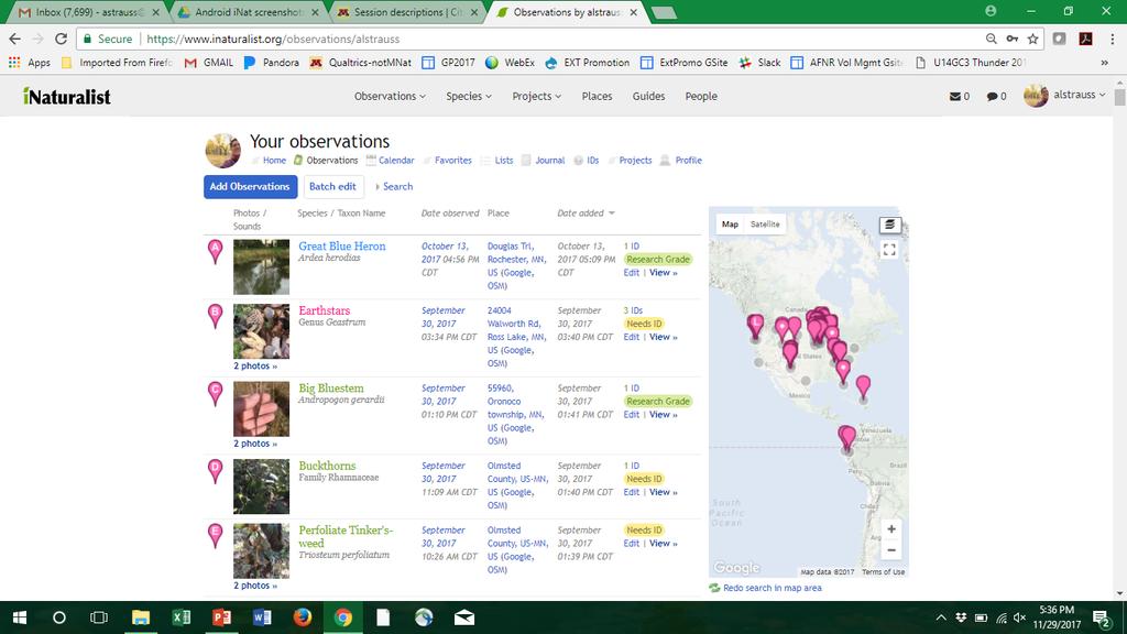
5 WHAT IS inaturalist? 5


6 WHAT IF I DON T KNOW WHAT IT IS? 6
7 WHAT IF I DON T KNOW WHAT IT IS? 7


8 City Nature Challenge APRIL

9 7 COUNTY METRO AREA 3 million+ people ~3,000 square miles Hennepin Ramsey Dakota Anoka Washington Scott Carver 9


10 OBSERVATIONS 10
 11")
11 16 CITIES ALL MSP DLH Observations 124, Species People Middle of the Pack: - Low ratio of observations to species - % that became research grade - Average observations per person (~20) 11

12 COMPARED TO SAME 5 DAYS PREVIOUS YEAR #8 Minneapolis/ St. Paul Duluth #1 20x Increase in Observations 236x 6.7x Increase in Species 85x 46x Increase in People 6x 12
13 CITIES ONBOARD FOR CNC 2018 Mpls/St Paul Nashville El Paso New York City Omaha San Francisco Vilnius Duluth Calabar Fort Collins Luxembourg Phoenix Sao Paulo Washington DC Amarillo Cartagena Guimaraes Madrid Plymouth Seattle Waterloo Austin Charlottesville Hermosillo Maine Prague Sevilla Altadena Baltimore Chennai Houston Maui Pune St Louis Edmonton Bangalore Chicago Indianapolis Medford Raleigh Sydney Boulder Barcelona Cleveland Kansas City Merimbula Richmond Tokyo Buenos Aires Bay of Cadiz Colmenar Viejo Kolkata Miami Rio de Janeiro Trieste London Berlin Colombia Kuala Lumpur Ahmedabad Riverside Tulsa Los Angeles Boston Dallas/Ft Worth La Plata Monterrey Rome Vancouver Mumbai 13

14 GET INVOLVED IN THE 2018 CHALLENGE! Seeking organizational partners to help Drive participation Raise awareness Support inaturalist use 14

15 DRIVE PARTICIPATION Host an inaturalist party before or during CNC Hold a BioBlitz Schedule staff experts to be on hand all day 15

16 RAISE AWARENESS Of cit sci & biodiversity Post to your social media, events calendars, websites, bulletin boards, etc. 16

17 SUPPORT inaturalist USE Train staff & participants to use inaturalist Help identify species observed 17
18 WHO ELSE IS IN FOR 2018? University of Minnesota Extension (i.e. Master Naturalist Program) Minnesota Sea Grant Program The Science Museum of MN Mississippi National River & Recreation Area The Bell Museum Minnesota Naturalist s Association MN Department of Natural Resources US Forest Service The Bell Museum Twin Cities Public Television REI YOUR organization or agency?? 18
19 NEXT STEPS Mark your calendar! Leave your name/info with me Attend a web-call for all prospective partners soon 19

20 Join by letting me know to include you in the partner meeting! The University of Minnesota is an equal opportunity educator and employer. In accordance with the Americans with Disabilities Act, this PowerPoint is available in alternative formats upon request. Direct requests to
Research Update: Race and Male Joblessness in Milwaukee: 2008
 Research Update: Race and Male Joblessness in Milwaukee: 2008 by: Marc V. Levine University of Wisconsin Milwaukee Center for Economic Development Briefing Paper September 2009 Overview Over the past decade,
Kathryn Robinson. Grades 3-5. From the Just Turn & Share Centers Series VOLUME 12
 1 2 From the Just Turn & Share Centers Series VOLUME 12 Temperature TM From the Just Turn & Share Centers Series Kathryn Robinson 3 4 M Enterprises WriteMath Enterprises 2303 Marseille Ct. Suite 104 Valrico,
Heat and Health: Reducing the Impact of the Leading Weather-Related Killer
 Heat and Health: Reducing the Impact of the Leading Weather-Related Killer Laurence S. Kalkstein, Ph.D. Department of Public Health Sciences Miller School of Medicine University of Miami June, 2017 Quick
Scaling in Biology. How do properties of living systems change as their size is varied?
 Scaling in Biology How do properties of living systems change as their size is varied? Example: How does basal metabolic rate (heat radiation) vary as a function of an animal s body mass? Mouse Hamster
Oklahoma Academic Standards Science Grade: 6 - Adopted: 2014
 Main Criteria: Oklahoma Academic Standards Secondary Criteria: Subjects: Science, Social Studies Grade: 6 Correlation Options: Show Correlated OK.6-LS. Oklahoma Academic Standards Science Grade: 6 - Adopted:
Lesson 1 - Pre-Visit Safe at Home: Location, Place, and Baseball
 Lesson 1 - Pre-Visit Safe at Home: Location, Place, and Baseball Objective: Students will be able to: Define location and place, two of the five themes of geography. Give reasons for the use of latitude
2/25/2019. Taking the northern and southern hemispheres together, on average the world s population lives 24 degrees from the equator.
 Where is the world s population? Roughly 88 percent of the world s population lives in the Northern Hemisphere, with about half north of 27 degrees north Taking the northern and southern hemispheres together,
Vibrancy and Property Performance of Major U.S. Employment Centers. Appendix A
 Appendix A DOWNTOWN VIBRANCY SCORES Atlanta 103.3 Minneapolis 152.8 Austin 112.3 Nashville 83.5 Baltimore 151.3 New Orleans 124.3 Birmingham 59.3 New York Midtown 448.6 Charlotte 94.1 Oakland 157.7 Chicago
Lab Activity: Weather Variables
 Name: Date: Period: Weather The Physical Setting: Earth Science Lab Activity: Weather Variables INTRODUCTION: A meteorologist is an individual with specialized education who uses scientific principles
The Elusive Connection between Density and Transit Use
 The Elusive Connection between Density and Transit Use Abstract: The connection between density and transportation is heralded by planners, yet results are often elusive. This paper analyzes two regions,
HI SUMMER WORK
 HI-201 2018-2019 SUMMER WORK This packet belongs to: Dear Dual Enrollment Student, May 7 th, 2018 Dual Enrollment United States History is a challenging adventure. Though the year holds countless hours
Chapter 4: Displaying and Summarizing Quantitative Data
 Chapter 4: Displaying and Summarizing Quantitative Data This chapter discusses methods of displaying quantitative data. The objective is describe the distribution of the data. The figure below shows three
NAWIC. National Association of Women in Construction. Membership Report. August 2009
 NAWIC National Association of Women in Construction Membership Report August 2009 Core Purpose: To enhance the success of women in the construction industry Region 1 67 Gr Washington, DC 9 16 2 3 1 0 0
Trends in Metropolitan Network Circuity
 Trends in Metropolitan Network Circuity David J. Giacomin Luke S. James David M. Levinson Abstract Because people seek to minimize their time and travel distance (or cost) when commuting, the circuity
North American Geography. Lesson 5: Barnstorm Like a Tennis Player!
 North American Geography Lesson 5: Barnstorm Like a Tennis Player! Unit Overview: As students work through the activities in this unit they will be introduced to the United States in general, different
Powder River Basin Coal Update
 Powder River Basin Coal Update Tom Kraemer Group Vice President Coal Southwest Power Pool Regional State Committee October 24, 2005 - Santa Fe, NM Discussion Topics BNSF coal transportation Historic PRB
Density and Walkable Communities
 Density and Walkable Communities Reid Ewing Professor & Chair City and Metropolitan Planning University of Utah ewing@arch.utah.edu Department of City & Metropolitan Planning, University of Utah MRC Research
Hennepin GIS. Tree Planting Priority Areas - Analysis Methodology. GIS Services April 2018 GOAL:
 Hennepin GIS GIS Services April 2018 Tree Planting Priority Areas - Analysis Methodology GOAL: To create a GIS data layer that will aid Hennepin County Environment & Energy staff in determining where to
22 cities with at least 10 million people See map for cities with red dots
 22 cities with at least 10 million people See map for cities with red dots Seven of these are in LDC s, more in future Fastest growing, high natural increase rates, loss of farming jobs and resulting migration
Investigation 11.3 Weather Maps
 Name: Date: Investigation 11.3 Weather Maps What can you identify weather patterns based on information read on a weather map? There have been some amazing technological advancements in the gathering and
JUPITER MILLER BUSINESS CENTER 746,400 SF FOR LEASE
 746,400 SF FOR LEASE Three LEED Certified Cross-Dock Buildings 54,600 Square Feet to 746,400 Square Feet Available Dallas City of Tax Incentives Available 36 Clear Height (Over 25% More Pallet Positions
Access Across America: Transit 2017
 Access Across America: Transit 2017 Final Report Prepared by: Andrew Owen Brendan Murphy Accessibility Observatory Center for Transportation Studies University of Minnesota CTS 18-12 1. Report No. CTS
Access Across America: Transit 2016
 Access Across America: Transit 2016 Final Report Prepared by: Andrew Owen Brendan Murphy Accessibility Observatory Center for Transportation Studies University of Minnesota David Levinson School of Civil
Hotel Industry Overview. UPDATE: Trends and outlook for Northern California. Vail R. Brown
 Hotel Industry Overview UPDATE: Trends and outlook for Northern California Vail R. Brown Senior Vice President, Global Business Development & Marketing vbrown@str.com @vail_str 2016 STR, Inc. All Rights
Solving Quadratic Equations by Graphing 6.1. ft /sec. The height of the arrow h(t) in terms
 in terms") Quadratic Function f ( x) ax bx c Solving Quadratic Equations by Graphing 6.1 Write each in quadratic form. Example 1 f ( x) 3( x + ) Example Graph f ( x) x + 6 x + 8 Example 3 An arrow is shot upward
Quadratic Function f ( x) ax bx c Solving Quadratic Equations by Graphing 6.1 Write each in quadratic form. Example 1 f ( x) 3( x + ) Example Graph f ( x) x + 6 x + 8 Example 3 An arrow is shot upward
American Tour: Climate Objective To introduce contour maps as data displays.
 American Tour: Climate Objective To introduce contour maps as data displays. www.everydaymathonline.com epresentations etoolkit Algorithms Practice EM Facts Workshop Game Family Letters Assessment Management
34 ab ArchitectureBoston
 Postmodern theorists writing in the late 20th-century once surmised that, during an era of airplanes, cell phones, and the Internet, the importance of geographical space was quickly diminishing. The French
Impacts of Transit Rail Lines on Property Values
 Impacts of Transit Rail Lines on Property Values Rail~Volution 2007 Introduction The Question Research Tools Methodology Examples Results Question Won t transit in my backyard hurt my property value?
ASSESSING ACCURACY: HOTEL HORIZONS FORECASTS
 ASSESSING ACCURACY: HOTEL HORIZONS FORECASTS April 13, 2016 EXECUTIVE SUMMARY The US hotel industry had another strong year in 2015 with RevPAR up 6.3 percent over the prior year. In this report, we examine
Using the ACS to track the economic performance of U.S. inner cities
 Using the ACS to track the economic performance of U.S. inner cities 2017 ACS Data Users Conference May 11, 2017 Austin Nijhuis, Senior Research Analyst Initiative for a Competitive Inner (ICIC) ICIC ICIC
Your web browser (Safari 7) is out of date. For more security, comfort and the best experience on this site: Update your browser Ignore
 is out of date. For more security, comfort and the best experience on this site: Update your browser Ignore") Your web browser (Safari 7) is out of date. For more security, comfort and the best experience on this site: Update your browser Ignore Educator Version TRACKING GRO W TH IN THE U.S. Late 19th century
Your web browser (Safari 7) is out of date. For more security, comfort and the best experience on this site: Update your browser Ignore Educator Version TRACKING GRO W TH IN THE U.S. Late 19th century
Henrico County Public Library (HCPL) first partnered with the Richmond Astronomical Society
 first partnered with the Richmond Astronomical Society") Page 1 1. Program Overview Henrico County Public Library (HCPL) first partnered with the Richmond Astronomical Society to present Observe the Moon Night in 2015 at Twin Hickory Library. The program aimed
Page 1 1. Program Overview Henrico County Public Library (HCPL) first partnered with the Richmond Astronomical Society to present Observe the Moon Night in 2015 at Twin Hickory Library. The program aimed
About WE RE A PASSIONATE COMPANY FILLED WITH PASSIONATE INDIVIDUALS OUR MISSION OUR VISION OUR TAGLINE OUR NAME
 Media Kit About For more than 65 years, The Arc Northern Chesapeake Region (The Arc NCR) has helped people with intellectual and developmental disabilities to live, work and play in Harford and Cecil Counties.
Cambridge IGCSE Geography past paper questions
 Cambridge IGCSE Geography Past paper questions are reproduced by permission of University of Cambridge International Examinations. QUESTION 1: Cambridge IGCSE Geography 04/01 Q2 June 2005 (a) Study Fig.
April 19, California Energy Commission (CEC)
") April 19, 2012 California Energy Commission (CEC) Re: March 12, 2012 45-day Language Hearing for Nonresidential Buildings - 2013 Building Energy Efficiency Standards (AHRI Comments on 140.4(e)4; Docket
April 19, 2012 California Energy Commission (CEC) Re: March 12, 2012 45-day Language Hearing for Nonresidential Buildings - 2013 Building Energy Efficiency Standards (AHRI Comments on 140.4(e)4; Docket
Antelope Island State Park International Dark Sky Park Annual Report 2018
 Antelope Island State Park International Dark Sky Park Annual Report 2018 Photo by Ryan Andreasen Antelope Island State Park IDA Contact: Wendy Wilson Assistant Park Manager wendywilson@utah.gov 801-230-6155
Internet GIS Sites. 2 OakMapper webgis Application
 Internet GIS Sites # Name URL Description 1 City of Sugar Land http://www.sugarlandtx.gov/index.htm It is a city in Texas with 65,000 Residents. The City of Sugar Land, Texas, provides ArcIMS-based maps
Rank University AMJ AMR ASQ JAP OBHDP OS PPSYCH SMJ SUM 1 University of Pennsylvania (T) Michigan State University
 Michigan State University") Rank University AMJ AMR ASQ JAP OBHDP OS PPSYCH SMJ SUM 1 University of Pennsylvania 4 1 2 0 2 4 0 9 22 2(T) Michigan State University 2 0 0 9 1 0 0 4 16 University of Michigan 3 0 2 5 2 0 0 4 16 4 Harvard
Rank University AMJ AMR ASQ JAP OBHDP OS PPSYCH SMJ SUM 1 University of Pennsylvania 4 1 2 0 2 4 0 9 22 2(T) Michigan State University 2 0 0 9 1 0 0 4 16 University of Michigan 3 0 2 5 2 0 0 4 16 4 Harvard
Extreme Temperature Protocol in Middlesex-London
 Clean Air Partnership Webinar March 17, 2009 Extreme Temperature Protocol in Middlesex-London Presented by Iqbal Kalsi, MBA, CPHI(C), CCEP iqbal.kalsi@mlhu.on.ca 1 History Informal monitoring, tracking
Pima Community College Students who Enrolled at Top 200 Ranked Universities
 Pima Community College Students who Enrolled at Top 200 Ranked Universities Institutional Research, Planning and Effectiveness Project #20170814-MH-60-CIR August 2017 Students who Attended Pima Community
Regional Growth Strategy Regional TOD Advisory Committee
 Regional Strategy Regional TOD Advisory Committee September 21, 2018 Overview Regional Geographies Transit-Oriented Development Goal Scenarios Next Steps 2 Schedule + Process September 6 Management Policy
OREGON POPULATION FORECAST PROGRAM
 OREGON POPULATION FORECAST PROGRAM PROGRAM OVERVIEW BACKGROUND Beginning in 1973 with the passage of Senate Bill (SB) 100, Oregon s growth management system has relied on population forecasts as the primary
11/7/2018. Q: What is this? What is in this area of the country?
 Update on Upcoming Learning Opportunities: GEOG Courses Related to Cities and the Economy Murray Rice Spring 2019: GEOG 4230 (Location Intelligence: Business GIS) Focus on GIS applications in business
Urbanisation & Economic Geography (2)
") GEOG1101: Introduction to Economic Geography Tuesday 20 October, 2009 Urbanisation & Economic Geography (2) Kevon Rhiney Department of Geography and Geology University of the West Indies, Mona Lecture
GEOG1101: Introduction to Economic Geography Tuesday 20 October, 2009 Urbanisation & Economic Geography (2) Kevon Rhiney Department of Geography and Geology University of the West Indies, Mona Lecture
3/21/2019. Q: What is this? What is in this area of the country? Q: So what is this? GEOG 3100 Next Week
 Tuesday: Thursday: GEOG 3100 Next Week Discussion of The South region (in this room) GIS Computer Lab Time (ENV Building, Room 340 more on this in class on Tuesday next week) Ahead of this lab time, please
Climate Uncovered: Media Fail to Connect Hurricane Florence to Climate Change
 September 18, 2018 Climate Uncovered: Media Fail to Connect Hurricane Florence to Climate Change One of the clearest and most devastating impacts of climate change has been the intensification of the harm
Citizen Centric Cities. The Sustainable Cities Index 2018 Europe
 Citizen Centric Cities The Sustainable Cities Index 2018 Europe Foreword The 2018 edition of Arcadis Sustainable Cities Index (SCI) explores city sustainability from the perspective of the citizen. We
Porous Europe: European Cities in Global Urban Arenas
 Porous Europe: European Cities in Global Urban Arenas Ben Derudder & Peter Taylor Globalization and World Cities study group and network (GaWC, http://www.lboro.ac.uk/gawc) Rationale Three basic observations:
Mathematics with Applications
 Mathematics with Applications in the Management, Natural, and Social Sciences For these Global Editions, the editorial team at Pearson has collaborated with educators across the world to address a wide
CHAPTER 6: AIR MASSES & WEATHER PATTERNS
 CHAPTER 6: AIR MASSES & WEATHER PATTERNS METEOROLOGY NAME: PERIOD: Chapter 6 - Air Masses & Weather Patterns 1 Mr. Mihalik, Room 442 YOUR SHOT AT FORECASTING The project we ve all been waiting for... you
Compact city policies: a comparative assessment
 Compact city policies: a comparative TADASHI MATSUMOTO Organisation for Economic Co-operation and Development (OECD) Presentation at the UNECE-OECD seminar September 26, 2012, Geneva Outline of the study
1. Evaluation of maximum daily temperature
 1. Evaluation of maximum daily temperature The cumulative distribution of maximum daily temperature is shown in Figure S1. Overall, among all of the 23 states, the cumulative distributions of daily maximum
Council Workshop on Neighbourhoods Thursday, October 4 th, :00 to 4:00 p.m. Burlington Performing Arts Centre
 Council Workshop on Neighbourhoods Thursday, October 4 th, 2012 1:00 to 4:00 p.m. Burlington Performing Arts Centre Agenda Introductions Warm-Up Exercise Presentation Exercise Neighbourhood Planning Break
LOCAL GOVERNMENT ADMINISTRATION SERIES
 Public Policy Research Center University of Missouri St. Louis LOCAL GOVERNMENT ADMINISTRATION SERIES ISSUE #3 MARCH 2017 THE GOVERNOR IN GOVERNANCE: KEEPING THE PACE by Mark Tranel, Director, Public Policy
The Spatial Structure of Cities in the United States
 The Spatial Structure of Cities in the United States Gerrit-Jan Knaap, Rebecca Lewis and Jamie Schindewolf In recent years, the spatial structure of cities has become the subject of considerable interest,
6/25/2018. Upcoming Classes After Today. Our Only Presentation Day: Monday, July 2
 Upcoming Classes After Today Tuesday (June 26): Pacific Northwest and the Northlands Wednesday (June 27): Geographic Literacy in America; Take-Home Midterm Exam #2 distributed and discussed Thursday (June
Call for Hosting the 16 th World (ISSP) Congress in Sport Psychology in 2025
 Congress in Sport Psychology in 2025") Call for Hosting the 16 th World (ISSP) Congress in Sport Psychology in 2025 The International Society of Sport Psychology (ISSP) encourages groups and organizations to host the 16 th World Congress in
Call for Hosting the 16 th World (ISSP) Congress in Sport Psychology in 2025 The International Society of Sport Psychology (ISSP) encourages groups and organizations to host the 16 th World Congress in
Texas Statewide Mesonet Network (TexMesonet) Dr. Kantave Greene 11/15/17
 Dr. Kantave Greene 11/15/17") Texas Statewide Mesonet Network (TexMesonet) Dr. Kantave Greene 11/15/17 1 Observe weather features Why Mesonets? Thunderstorms Squall lines Dry-lines Sea breezes Improve weather & flood forecasts Drought
Texas Statewide Mesonet Network (TexMesonet) Dr. Kantave Greene 11/15/17 1 Observe weather features Why Mesonets? Thunderstorms Squall lines Dry-lines Sea breezes Improve weather & flood forecasts Drought
11.481J / 1.284J / ESD.192J Analyzing and Accounting for Regional Economic Growth Spring 2009
 MIT OpenCourseWare http://ocw.mit.edu 11.481J / 1.284J / ESD.192J Analyzing and Accounting for Regional Economic Growth Spring 2009 For information about citing these materials or our Terms of Use, visit:
C) Discuss two factors that are contributing to the rapid geographical shifts in urbanization on a global scale.
 Discuss two factors that are contributing to the rapid geographical shifts in urbanization on a global scale.") AP Human Geography Unit VII. Cities and Urban Land Use Free Response Questions FRQ 1 Rapid urbanization in Least Developed Countries (LDCs) has many profound impacts for the world. Answer the following
AP Human Geography Unit VII. Cities and Urban Land Use Free Response Questions FRQ 1 Rapid urbanization in Least Developed Countries (LDCs) has many profound impacts for the world. Answer the following
Summary of Terminal Master s Degree Programs in Philosophy
 Summary of Terminal Master s Degree Programs in Philosophy Faculty and Student Demographics All data collected by the ican Philosophical Association. The data in this publication have been provided by
Regional Economic Competitiveness Local Comprehensive Planning. An End-of-year Update to the Metropolitan Council Community Development Committee
 Regional Economic Competitiveness Local Comprehensive Planning An End-of-year Update to the Metropolitan Council Community Development Committee 12/21/2015 Regional Economic Competitiveness The ability
The Macalester Geography Crow River Watershed Project
 The Macalester Geography Crow River Watershed Project A Collaborative Project Between: Advanced d GIS Cities of the 21 st Century Urban Geography Field Seminar Talk Overview Introduction to the Project
Mapping Accessibility Over Time
 Journal of Maps, 2006, 76-87 Mapping Accessibility Over Time AHMED EL-GENEIDY and DAVID LEVINSON University of Minnesota, 500 Pillsbury Drive S.E., Minneapolis, MN 55455, USA; geneidy@umn.edu (Received
EMPIRICAL POLITICAL ANALYSIS
 Eighth Edition SUB Hamburg A/533757 EMPIRICAL POLITICAL ANALYSIS QUANTITATIVE AND QUALITATIVE RESEARCH METHODS Craig Leonard Brians Virginia Polytechnic and State University Lars Willnat Indiana University
RNR 516A. Computer Cartography. Spring GIS Portfolio
 RNR 516A Computer Cartography Spring 2016 GIS Portfolio 1 Contents 1 Political and Locator Maps 3 2 Base Maps and Digitizing 4 3 Data Entry Report 5 4 Projections and Symbolization 6 5 Choropleth Mapping
SOUTH COAST COASTAL RECREATION METHODS
 SOUTH COAST COASTAL RECREATION METHODS A customized, web-based survey instrument, which utilizes Point 97 s Viewpoint survey and mapping technology, was used to collect spatially explicit data on coastal
Visual Thinking with Spatial Data: Using Spatial Organization to Access Library Information
 Visual Thinking with Spatial Data: Using Spatial Organization to Access Library Information MHS: Who we are Established 1846 Broad Collections Focus Library and Exhibits Statewide Network of Historic Sites
CoCoRaHS. Community Collaborative Rain, Hail, & Snow Network. Ashley Wolf Meteorologist NWS Green Bay Northeast Wisconsin CoCoRaHS Coordinator
 CoCoRaHS Community Collaborative Rain, Hail, & Snow Network Ashley Wolf Meteorologist NWS Green Bay Northeast Wisconsin CoCoRaHS Coordinator What is CoCoRaHS Who, What, Where and Whys of CoCoRaHS What?
Supporting Information for Immigrant community integration in world cities
 Supporting Information for Immigrant community integration in world cities Fabio Lamanna, 1 Maxime Lenormand, 2 María Henar Salas-Olmedo, 3 Gustavo Romanillos, 3 Bruno Gonçalves, 4 and José J. Ramasco
Austin. What is a Public Market? The original gathering place. Worldwide, ancient phenomenon. Ripe for a Public Market?
 Downtown Austin Alliance September 25, 2013 What is a Public Market? Austin Ripe for a Public Market? Have Public Goals Operate in Public Spaces Serve Locally Owned and Operated Businesses The original
SDI Developments in the World s Currently Existing Mega Cities
 SDI Developments in the World s Currently Existing Mega Cities Silke Boos and Hartmut Müller FIG Working Week 2009 Surveyors Key Role in Accelerated Development, Eilat, Israel, 3-8 May 2009 TS 1B SDI in
Ca H ill CI AMERICAN METEOROLOGICAL SOCIETY. *AMS Workshop: "Back to the Future: Old and New Forecasting Techniques"
 Ca H ill CI 1996 Boston, MA Boston, MA San Francisco, CA Edinburgh, Scotland Berlin, Germany Victoria, BC, Canada Clermont-Ferrand, France Norfolk, VA Norfolk, VA Fairbanks, AK Wakefield, MA Ljubljana,
JOB DESCRIPTION. Research Associate - Urban Economy and Employment
 JOB DESCRIPTION Research Associate - Urban Economy and Employment 2 Research Associate Urban Economy and Employment About Us The Indian Institute for Human Settlements (IIHS) is a national education institution
Authors: Antonella Zanobetti and Joel Schwartz
 Title: Mortality Displacement in the Association of Ozone with Mortality: An Analysis of 48 US Cities Authors: Antonella Zanobetti and Joel Schwartz ONLINE DATA SUPPLEMENT Additional Information on Materials
11/14/2017. Key City Focus: Phoenix
 Semester Project Reminder Semester Project presentations begin on Monday, November 20 (and continue on Monday, November 27 and Wednesday, November 27). See the presentation schedule posted online for your
C a AMERICAN METEOROLOGICAL SOCIETY UPCOMING AMS MEETINGS. * Third Conference on Coastal Atmospheric and Oceanic Prediction and Processes
 C a UPCOMING AMS MEETINGS New Orleans, LA 1999 3-5 November 2000 * Third Conference on Coastal Atmospheric and Oceanic Prediction and Processes *80th AMS Annual Meeting * AMS Short Course on Becoming a
GEOGRAPHY 2217/12 Paper 1 October/November 2014
 www.xtremepapers.com Cambridge International Examinations Cambridge Ordinary Level * 6 7 7 2 4 1 7 0 2 4 * GEOGRAPHY 2217/12 Paper 1 October/November 2014 Candidates answer on the Question Paper. Additional
Next Page US History, Ms. Brown Need Help? or Call
 Name Course: US History/Ms. Brown Date: Homeroom: 7th Grade US History Standard # Do Now Day #13 Aims: SWBAT perform a variety of geographical tasks in order to demonstrate mastery of unit one concepts
City Number Pct. 1.2 STEMS AND LEAVES
 1.2 STEMS AND LEAVES Think back on the preceding example. We dealt with a list of cities giving their populations and areas. Usually the science of statistics does not concern itself with identifying the
K- 5 Academic Standards in. Social Studies. June 2013
 K- 5 Academic s in Social Studies June 2013 Word Tables of s ONLY This Word version of the 2.17.12 social studies standards (DRAFT for Rulemaking 2.17.12) document contains the standards ONLY; no explanatory
Regional Snapshot Series: Transportation and Transit. Commuting and Places of Work in the Fraser Valley Regional District
 Regional Snapshot Series: Transportation and Transit Commuting and Places of Work in the Fraser Valley Regional District TABLE OF CONTENTS Complete Communities Daily Trips Live/Work Ratio Commuting Local
The use of modern sources of information in shaping the geographic literacy of Russian school students
 Journal of Subject Didactics, 2017 Vol. 2, No. 2, 67-71, DOI: 10.5281/zenodo.1239720 Short Review The use of modern sources of information in shaping the geographic literacy of Russian school students
GIS for the Beginner on a Budget
 GIS for the Beginner on a Budget Andre C. Bally, RLA, GIS Coordinator, Harris County Public Infrastructure Department Engineering Division This presentation, GIS for Beginners on a Budget. will briefly
Cities, Countries, and Population
 Cities, Countries, and Population After the world industrialized, better food, improved sanitation, and new medicines caused the world population to soar. To understand how heavily populated an area is,
ADMINISTRATION DEPARTMENT Land Management Information Center. An Inventory of Its Records
 MINNESOTA HISTORICAL SOCIETY Minnesota State Archives ADMINISTRATION DEPARTMENT Land Management Information Center An Inventory of Its Records OVERVIEW OF THE RECORDS Agency: Series Title: Land Management
ArcGIS Enterprise: Out-of-the-Box Spatial Analysis. Vicki Cove Hilary Curtis
 ArcGIS Enterprise: Out-of-the-Box Spatial Analysis Vicki Cove Hilary Curtis Agenda What is spatial analysis? Spatial analysis with ArcGIS Enterprise Analysis demos: - Sunflower proximity to bees - Tourists
Inter and Intra Buffer Variability: A Case Study Using Scale
 Georgia State University ScholarWorks @ Georgia State University Art and Design Faculty Publications Ernest G. Welch School of Art and Design 2015 Inter and Intra Buffer Variability: A Case Study Using
AMS Short Course: Cloud-based Data Exploration and Machine Learning on Environmental Datasets, 22 January, Seattle, Washington
 The Call for Papers and Calendar sections list conferences, symposia, and workshops that are of potential interest to AMS members. Complete information about events listed in the calendar can be found
, District of Columbia
 State Capitals These are the State Seals of each state. Fill in the blank with the name of each states capital city. (Hint: You may find it helpful to do the word search first to refresh your memory.),
Keywords: Travel Behavior; Transportation Finance; Global Positioning Systems (GPS)
") 0 0 0 How Local is Travel? Michael Scharenbroich Humphrey Institute of Public Affairs University of Minnesota 0 th Ave. S Minneapolis, MN scha0@umn.edu Michael Iacono* Department of Civil Engineering University
0 0 0 How Local is Travel? Michael Scharenbroich Humphrey Institute of Public Affairs University of Minnesota 0 th Ave. S Minneapolis, MN scha0@umn.edu Michael Iacono* Department of Civil Engineering University
Intercity Bus Stop Analysis
 by Karalyn Clouser, Research Associate and David Kack, Director of the Small Urban and Rural Livability Center Western Transportation Institute College of Engineering Montana State University Report prepared
Physical Features of Canada and the United States
 Physical Features of Canada and the United tates 170 ARCTIC OCA Aleutian s 1 1 Bering ea ALAKA Yukon R. Mt. McKinley (20,320 ft. 6,194 m) Gulf of Alaska BROOK RAG RAG Queen Charlotte s R Vancouver O C
ES1 Investigating Weather Maps/Station Models Act# 10 Name Block Date
 yay, bonus pt. because oops, no HO, book, heading this date =MP ES1 Investigating Weather Maps/Station Models Act# 10 Name Block Date Weather INTRODUCTION: Weather maps combine meteorological data from
Grade Four Content Overview
 Grade Four Content Overview Physical features Regions Contributions of the states Our Country: Geography and Regions Coastal and inland communities Famous landmarks Physical and human characteristics Local,
2010 Census Data Release and Current Geographic Programs. Michaellyn Garcia Geographer Seattle Regional Census Center
 2010 Census Data Release and Current Geographic Programs Michaellyn Garcia Geographer Seattle Regional Census Center 2010 Center of Population Located approximately 2.7 miles northeast of Plato, Missouri
Minnesota K-12 Academic Standards in Social Studies. Grade 4: Geography of North America
 Minnesota K-12 Academic s in Social Studies Grade 4: Geography of North America 4 Describe how people take 1. Democratic government action to influence a depends on informed and decision on a specific
Environment and Natural Resources Trust Fund 2019 Request for Proposals (RFP)
") Environment and Natural Resources Trust Fund 2019 Request for Proposals (RFP) Project Title: Data Visualization Tool for Minnesota Riverbed Habitat Category: A. Foundational Natural Resource Data and Information
Environment and Natural Resources Trust Fund 2019 Request for Proposals (RFP) Project Title: Data Visualization Tool for Minnesota Riverbed Habitat Category: A. Foundational Natural Resource Data and Information
Heritage and Cultural Tourism Management
 Unit 34: Heritage and Cultural Tourism Management Unit code: L/601/1757 QCF level: 4 Credit value: 15 Aim The aim of this unit is to enable learners to gain understanding of the heritage and cultural,
Ecological Land Cover Classification For a Natural Resources Inventory in the Kansas City Region, USA
 Ecological Land Cover Classification For a Natural Resources Inventory in the Kansas City Region, USA by Applied Ecological Services, Inc. In cooperation with the Mid-America Regional Council 600 Broadway,