Golconda Summit, Nevada
|
|
|
- Victoria Phillips
- 6 years ago
- Views:
Transcription
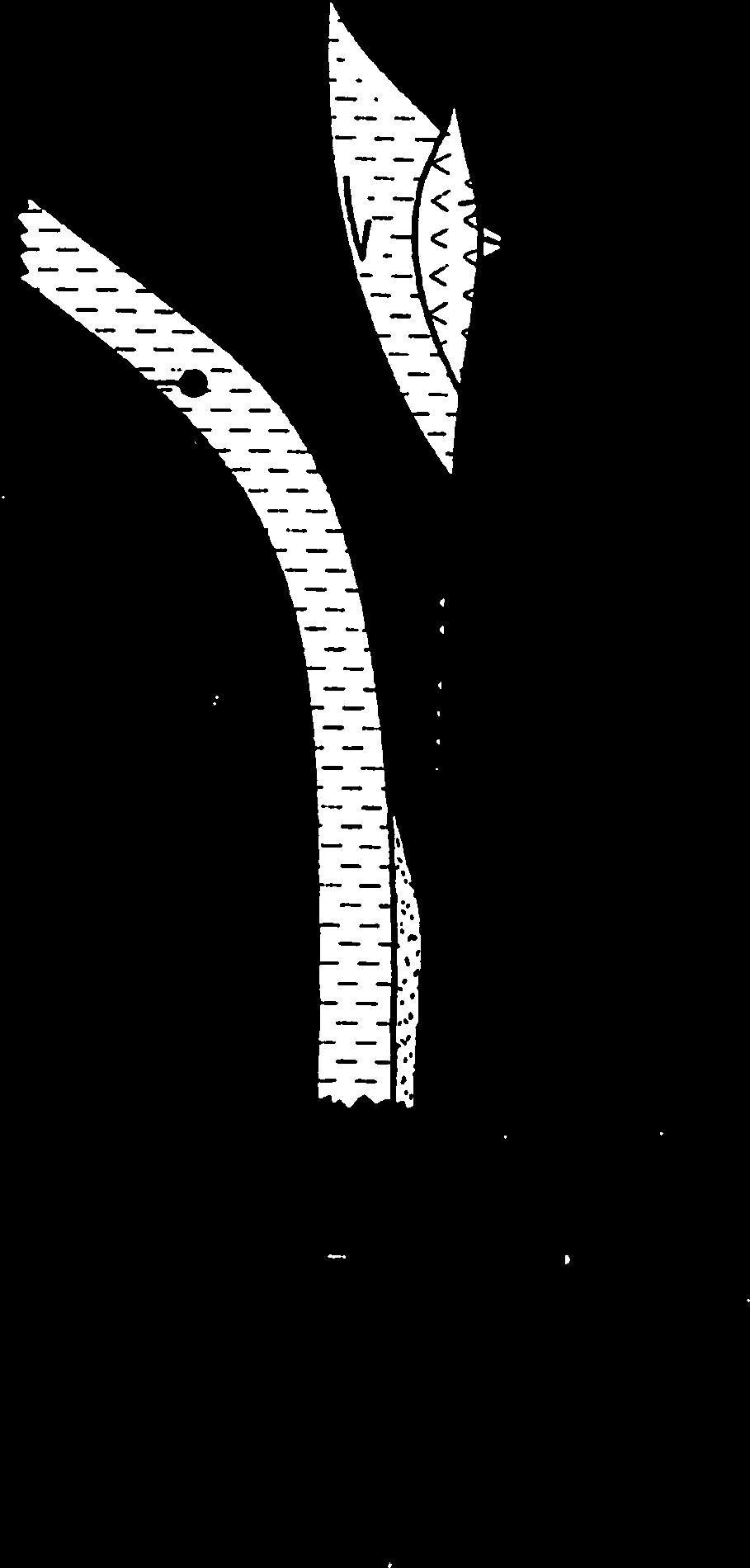
1 Penn quartzite Golconda Summit, Nevada Penn volcanics Penn ls hilltop Cambrian shales Penn LANF? Thrust? Golconda Thrust Golconda Summit, I80. Above highway where trucks are, Cambrian Preble Frm (phyllitic shale) under Antler Peak ls, Penn-Perm reef ls--juxtaposed on Iron Point fault (thrust on old maps, LANF in Cashman et al). Edna Mtn (Permian ss) at very top of hill. Small hill at right has Iron Point Thrust again within it. To left of highway, peak with antennae is Golconda Summit, which is Penn shale+chert of upper plate of Golconda allochthon. Ledge 1/3 way up is Antler Peak ls with brown Edna Mtn Frm above. Most of gray slopes behind is greenstone unit (basalts-andesites of Penn age) of upper plate of Golconda.


2 Miller et al., DNAG
3 Paleozoic Tectonic Domains of Nevada Pine Forest Range Hot Springs Range Jackson Mountains Humboldt Osgood Mountains Independence Mountains Granite Range Edna Mountain Elko Washoe Sonoma Range Battle Mountain Pershing East Range Tobin Range Lander Eureka Shoshone Range Storey Churchill White Pine Carson City Douglas Lyon Toiyabe Range Excelsior Mountains Mineral Pilot Mountains Candelaria Hills Esmeralda Nye? Lincoln Legend Nolan Belt Domain Antler Overlap Domain Golconda Domain and Home Ranch subterrane Black Rock-Jackson Domain Clark Crafford, Geosphere, 2008 Crafford notes lower plate pretty undeformed, but upper plate hammered in places relatively undeformed Tr on top. Also discuss Nolan belt, which is defined by Crafford as having continental affinity but higher grade metamorphism and west-verging thrusting in pre-mid-penn

4 Gehrels and Dickinson, Am J Sci. 1995
5 Both of these are Golconda allocthon sections. Independence Mtns in NE Nevada Riley et al., GSA SP 347, 2000
6 Figure 5. Relative age-probability curves for Paleozoic strata of Cordilleran miogeocline (Gehrels, this volume) and lower Paleozoic strata of Roberts Mountains allochthon (Gehrels et al., this volume, Chapter 1), Shoo Fly Complex (Harding et al., this volume), and Yreka terrane (Wallin et al., this volume). Ages of Trinity terrane intrusive rocks are from Wallin et al. (1995). B.C. British Columbia. Numbers in boxes refer to provenance links listed in Table 1. Gehrels et al., GSA SP 347, 2000
7 Gehrels et al., GSA SP 347, 2000 Figure 5. Relative age-probability curves for Paleozoic strata of Cordilleran miogeocline (Gehrels, this volume) and lower Paleozoic strata of Roberts Mountains allochthon (Gehrels et al., this volume, Chapter 1), Shoo Fly Complex (Harding et al., this volume), and Yreka terrane (Wallin et al., this volume). Ages of Trinity terrane intrusive rocks are from Wallin et al. (1995). B.C. British Columbia. Numbers in boxes refer to provenance links listed in Table 1.
8 Gehrels et al., GSA SP 347, 2000 Riley et al., GSA SP 347, 2000 Figure 7. Results of statistical comparisons of detrital zircon ages from

9 Miller et al., DNAG

10 Miller et al., DNAG Note lots of volcaniclastics as well as plutonic rocks
11 Miller et al., DNAG
12 Miller et al., DNAG


13 Miller et al., DNAG
14 Miller et al., DNAG
15 Miller et al., DNAG
16 Miller et al., DNAG
17 Miller et al., DNAG
18 Gehrels et al., GSA SP 347, 2000 What is the relationship of the Golconda rocks to North America? Back to detrital zircons [which are only a small part of sediment volume]
19 Original interpretation in 2000 is that all the terranes were connected Gehrels et al., GSA SP 347, 2000
20 Age (Ma) Slaven Chert (n=192) Elder Sandstone (n=189) Upper Vinini Fm McAfee Quartzite Lower Vinini Fm Snow Canyon Fm Figure 5. Relative age-probability curves for Paleozoic strata of Cordilleran mio(n=194) geocline (Gehrels, this volume) and lower Paleozoic strata of Roberts Mountains allochthon (Gehrels et al., this volume,(n=184) Chapter 1), Shoo Fly Complex (Harding et al., this volume), and Yreka terrane (Wallin et al., this volume). Ages of Trinity (n=189)terrane intrusive rocks are from Wallin et al. (1995). B.C. British Columbia. Numbers in boxes refer to provenance (n=189) links listed in Table Ksituan, and the Great Bear arcs (Hoffman, 1989; Ross, 1991; Villeneuve et al., 1993) (Fig. 7). The Ma grainsg.e. are similar in age Gehrels et to al.accreted terranes in the PRA region, including the Buffalo Head and Chincaga terranes (Hoffman, 1989; Ross, 1991; Villeneuve et al., 1993) (Fig. 7). The Ma grains are similar in age to Archean terranes in the PRA region, including the Nova and Hearne terranes (Hoffman, 1989; Ross, 1991; Villeneuve et al., 1993) (Fig. 7). The Hf isotope data are consistent with provenance in the PRA region. The Ma grains have a wide range of values, from juvenile and moderately juvenile through evolved (εhf(t) +10 to 15), similar to those of other units interpreted to originate in the PRA region (Gehrels and Pecha, 2014). The Ma grains are more narrowly grouped, with moderately juvenile to evolved values of εhf(t) +3 to 6, compatible with other units originating in the PRA region (Gehrels and Pecha, 2014). The Ma grains have juvenile, moderately juvenile, and evolved values of εhf(t) +6 to 15, also compatible with PRA origin (Gehrels and Pecha, 2014). The ages of basement terranes that comprise the PRA region (Fig. 7) are all represented in the age spectra of the RMA samples (exclusive of the lower Vinini Formation). The detrital zircon U-Pb ages and Hf isotope data from these RMA strata are similar to selected passive margin strata and RMA strata analyzed in other studies (Fig. 8). The RMA strata sampled in this study (exclusive of the lower Vinini) have U-Pb age spectra similar to those of the Ordovician Valmy Formation of the RMA (Gehrels and Pecha, 2014), as well as the Eureka Quartzite and the Mount Wilson Formation (Gehrels and Pecha, 2014), and the Kinnikinic Quartzite (Barr, 2009), Ordovician units of the western Laurentian passive margin (Figs. 8 and 9). The K-S analyses of the RMA and the Ordovician passive margin units discussed above do not contradict our interpretation that the RMA strata have a common provenance with the Ordovician passive margin sandstones (Table 2). These RMA strata also show similar Hf isotope ratios to the Valmy Formation (Gehrels and Pecha, 2014) and to the Eureka Quartzite and the Mount Wilson Formation (Gehrels and Pecha, 2014) (Fig. 8). The Peace River Arch region of western Canada is the source for the RMA units in this study, exclusive of the lower Vinini Formation, and for the Ordovician passive margin sandstones. The Peace River Arch region was an uplifted region from late Neoproterozoic through Middle Devonian time (Cant, 1988; Cant and O Connell, 1988; Cecile et al., 1997). Igneous bodies in the PRA region have ages similar to the U-Pb ages of zircons in the RMA rocks sampled (Figs. 7 and 8). The U-Pb age spectra of the RMA rocks sampled are not consistent with et al., GSA SPthe Yavapai-Mazatzal terranes are derivation from Gehrels the central Laurentian craton; 347, Ga and cannot serve as 2000 a source of the Ga grains in the samples Detrital Zircon Age (Ma) Provenance of the Lower Vinini Formation The U-P age spectra of the lower Vinini Formation are consistent with provenance in north-central Laurentia. The Ma grains are similar in age to plutonic suites in roof pendants and inliers within the Challis volcanic-plutonic complex and the Idaho batholith (Lund et al., 2010). The Ma grains are consistent with the Grenville orogen; the 1420 Ma grains are consistent with the central Laurentian anorogenic granites; the Ma grains are Linde et al., Geosphere., 2016 consistent with the Yavapai-Mazatzal terranes; and the Ma grains Mountain Quartzite [Yreka terrane]) may have been derived exposed basement rocks or their platformal cover and transported Worth recalling how the use of the LA-ICPMS measurements changed the interpretation of Gehrels s group. Note the Lower Vinini still has more of a directly from basement rocks exposed along the continental mar- across the miogeocline via channels carved into the continental gin, whereas more mature sandset were probably recycled shelf al. (Finney and Perry, 1991).to southern Laurentian look except for12 those 500 Maquartz ages, which Linde et now found as inliers in Idaho batholith and Challis GEOSPHERE Volume Number 3 Linde al. zircon U-Pb geochronology and Hfattribute isotope geochemistry of the materials Roberts Mountains allochthon Detrital 8 from miogeoclinal and/or platformal strata in the Peace River Units in the Roberts Mountains allochthon and Shoo Fly volcanics areas. arch region. Complex also contain detrital zircons of and ca. 0.7 Ga, Ordovician strata of the Roberts Mountains allochthon also contain Ga grains that originated in basement rocks of the southwestern United States (provenance link 3). As concluded by Finney and Perry (1991) on the basis of biostratigraphic and facies relations, there is a strong link between lower Middle Ordovician rocks of the Vinini Formation and coeval strata of the miogeocline directly to the east. Derivation of sediment from nearby continental sources apparently resulted from a low sea-level stand, during which sand was eroded from either which were most likely shed from basement rocks exposed along the southern continental margin (Wallin, 1990a) (provenance links 1 and 6). The dominant source may have been a westward continuation of Ga rocks of the Grenville province, perhaps now preserved in the Oaxaca terrane of Mexico (Coney and Campa, 1987; Ruiz et al., 1988). The 0.7 Ga grains in the Harmony Formation were originally reported to have an uncertain provenance (Wallin, 1990a; Smith and Gehrels, 1994), but the unique occurrence of a 0.7 Ga grain in
21 2000 interpretation Gehrels et al., GSA SP 347, , 2000

22 2016 interpretation Linde et al., Geosphere., 2016 Early Ordovician Peace River Arch 2000 interpretation Gehrels et al., GSA SP 347, , Km B No Late Cambrian interpretation Valmy Lower Vinini 1000 Km 1000 Km C N Osgood/Geersten Transcontinental Ar N Peace River Arch Middle Ordovician Peace River Arch Late Silurian Peace River Arch Upper Vinini Valmy per Vinini Valmy Elder Longshore Transport Eureka Kinnikinic Transcontinental Arch Longshore Transport Eureka Kinnikinic Transcontinental Ar Transcontinental Arch subduction transform ridge 1000 Km E 1000 Km F 1000 Km N N Peace River Arch Peace River Arch RMA Transcontinental Arch Transcontinental Arch RMA Transcontinental Arch Late Devonian Middle Ordovician through Mississippian time (Blakey, 2013). Stars represent the depositional basin of Roberts Mountains allochthon (RMA) strata. White lines show the approximate approximate depositional pathways of units discussed. Transcontinental Arch (Sloss, 1988) and Peace River Arch (Ross, 1991) are superimposed. (A) Early Ordovician time. The lower Vinini tal Arch; the Valmy Formation is derived from the Peace River Arch. (B) Middle Ordovician time. The upper Vinini and Valmy formations are shed from the Peace River Arch into an oceanic Peace River Arch and transported via longshore current along the western Laurentian margin. (C) Late Silurian time. The Elder Sandstone is shed from the Peace River Arch region. (D) Middle e Peace River Arch. A Scotia-style arc has moved to the western margin of northern Laurentia, and a sinistral transpressional fault system has developed along the western margin. RMA argin by this fault system. (E) Late Devonian time. Subduction has initiated along much of the western margin of Laurentia, moving the RMA strata onto the craton. (F) Early Mississippian a into a highland on the western Laurentian margin.


23 2016 interpretation Linde et al., Geosphere., 2016 Late Devonian 2000 interpretation Gehrels et al., GSA SP 347, , 2000 Mid to Late Paleozoic Peace River Arch RMA Transcontinental Arch Figure 9. Schematic map of western North America showing our pre-
24 Figure 9. Schematic map of western North America showing our preferred paleogeography for Cordilleran margin during late Paleozoic time. Cratonal provinces and miogeoclinal strata are as shown in Figure 1. Horizontal ruled region represents arc-type terranes such as eastern Klamath terrane. Vertical ruled region represents basinal assemblages, such as Golconda allochthon, that formed in backarc basin setting. Small inverted V pattern represents extensional, east-facing arc active during emplacement of Roberts Mountains allochthon (following Burchfiel and Royden, 1991). Large inverted V pattern represents west-facing magmatic arc that is interpreted to have been active after Antler orogeny. Small black arrows show the inferred directions of crustal extension within this arc system. KT Kootenay terrane, BRT Black Rock terrane, GA Golconda allochthon, EKT eastern Klamath terrane, RMA Roberts Mountains allochthon, NST northern Sierra terrane. Large gray arrows reflect the general transport of sand that accumulated within miogeoclinal strata (Gehrels, Introduction). Figure 12. Schematic map of western North America showing our p ferred paleogeography for Cordilleran margin during Triassic time. C tonal provinces and miogeoclinal strata are as shown in Figure Horizontal ruled region represents arc-type terranes such as eastern K math terrane. Vertical ruled region represents basinal assemblages central Nevada that formed in backarc basin setting. Inverted V patte represents trace of west-facing magmatic arc outboard of Cordiller margin. Small black arrows show inferred direction of crustal extensi behind this arc system. Large gray arrows reflect the general transport sand that accumulated within miogeoclinal strata (Gehrels, this volum Introduction). KT Kootenay terrane, BRT Black Rock terrane, TT Trinity terrane, YT Yreka terrane, GA Golconda allochthon, EKT eastern Klamath terrane, RMA Roberts Mountains allochthon, NST northern Sierra terrane, TA Triassic assemblages. Gehrels et al., GSA SP 347, 2000
25 Figure 5. Relative age-probability curves for Paleozoic strata of Cordilleran miogeocline (Gehrels, this volume) and lower Paleozoic strata of Roberts Mountains allochthon (Gehrels et al., this volume, Chapter 1), Shoo Fly Complex (Harding et al., this volume), and Yreka terrane (Wallin et al., this volume). Ages of Trinity terrane intrusive rocks are from Wallin et al. (1995). B.C. British Columbia. Numbers in boxes refer to provenance links listed in Table 1. Gehrels et al., GSA SP 347, 2000
26 Colpron and Nelson, Geol Soc Lond Spec Pub 318, 2009

27 Colpron and Nelson, Geol Soc Lond Spec Pub 318, 2009 We need to start looking farther afield to see how to connect things up.

28 Colpron and Nelson, Geol Soc Lond Spec Pub 318, 2009
29 Cambrian Miogeocline in western NAM. Gehrels and Pecha, Geosphere, 2014 Alaska Northern BC Southern BC Nevada-Utah California Sonora Gehrels et al., GSA SP 347, 2000 Colprin and Nelson connect allocthons in lower Shoo Fly with northern BC based on the older TIMS detrital zircon work. Here we compare with newer stuff, and maybe OK. Lang-Duncan Peak-Culbertson

30 Allochthons in western NAM. Colpron and Nelson, Geol Soc Lond Spec Pub 318, 2009 Gehrels et al., GSA SP 347, 2000 Colprin and Nelson connect allocthons in lower Shoo Fly with northern BC based on the older TIMS detrital zircon work. Here we compare with newer stuff, and maybe OK. Lang-Duncan Peak-Culbertson
31 Figure 4. Summary of existing tectonic models for Cordilleran margin. A, Consistently west facing convergent margin with arc separated by series of marginal basins (Burchfiel and Davis, 1972, 1975; Churkin, 1974; Miller et al., 1984, 1992; Harwood and Murchey, 1990; Burchfiel etal., 1992). B, Collision of exotic arc during Antler orogeny followed by mainly west facing convergent margin (Schweickert and Snyder, 1981). C, Collision of two east-facing arc systems during Antler and Sonoma orogenies (Dickinson, 1977; Speed, 1979; Speed and Sleep, 1982; Dickinson et al., 1983). D, Generally west facing convergent margin with brief phases of east-facing subduction and extensional arc magmatism during Antler and Sonoma orogenies (Burchfiel and Royden, 1991; Burchfiel et al., 1992). Gehrels et al., SP 347, 2000 Significance of Sonoman orogen: Seems to reflect the collapse of some marginal oceanic belt between Sierran-Klamath arc to west and Roberts Mtn stuff to east. But there seem to be issues at the early end of the spectrum
Hildebrand Analysis: Topic 4
 Steven Plescia 12/9/16 Hildebrand Analysis: Topic 4 Hildebrand interprets much of the classic late pc-paloezoic Cordilleran miogeocline as exotic to North America Is there a break in the detrital zircons
Topics Laramide Orogeny: Late Cretaceous to Early Eocene Reading: GSA DNAG volume 3, Ch. 6
 Topics Laramide Orogeny: Late Cretaceous to Early Eocene Reading: GSA DNAG volume 3, Ch. 6 Late Cretaceous to early Eocene New patterns developed 5 main regions Tectonic interpretations Post-Laramide events
Geology 15 West Valley College. Exam IV: Sierra Nevada
 Geology 15 West Valley College Name Exam IV: Sierra Nevada 1) On the diagram above, where is the Arc- Trench Gap? a. 1 and 3 c. 7 and 8 d. 6 e. 5 and 10 2) On the diagram above, where is the subduction
Non-ideal Subduction
 Subduction zone cross sections Earthquake locations : black = teleseismic est. gray = local-array est. red line = top of slab seismicity blue line = center of slab seismicity Non-ideal Subduction Oblique
Quiz Nine (9:30-9:35 AM)
") Quiz Nine (9:30-9:35 AM) UNIVERSITY OF SOUTH ALAAMA GY 112: Earth History Lecture 25: Paleozoic 2: More Laurentia! Instructor: Dr. Douglas W. Haywick Last Time The Paleozoic of North America 1) Laurentian
Quiz Nine (9:30-9:35 AM) UNIVERSITY OF SOUTH ALAAMA GY 112: Earth History Lecture 25: Paleozoic 2: More Laurentia! Instructor: Dr. Douglas W. Haywick Last Time The Paleozoic of North America 1) Laurentian
Mesozoic Earth History
 Mesozoic Earth History The Mesozoic Era 251-66 MYA Breakup of Pangea Changes in air and oceanic currents Evolution of new terrestrial and marine life Opening of the Atlantic Ocean Basin Rocky Mountains
GY 112: Earth History
 UNIVERSITY OF SOUTH ALABAMA GY 112: Earth History Lectures 31: Mesozoic Tectonics Instructor: Dr. Douglas W. Haywick Last Time Mesozoic Overview A) The end of the Paleozoic B) Mesozoic time frame and evolutionary
Mesozoic Tectonics of the Blue Mountains Province
 Mesozoic Tectonics of the Blue Mountains Province Main Events Middle Triassic: normal subduction and facing arcs Late Triassic: arc-arc collision (?) Jurassic: long-lived terrane-continent collision (?)
Copyright McGraw-Hill Education. All rights reserved. No reproduction or distribution without the prior written consent of McGraw-Hill Education
 Copyright McGraw-Hill Education. All rights reserved. No reproduction or distribution without the prior written consent of McGraw-Hill Education Tibetan Plateau and Himalaya -southern Asia 11.00.a VE 10X
Strike-Slip Faults. ! Fault motion is parallel to the strike of the fault.
 Strike-Slip Faults! Fault motion is parallel to the strike of the fault.! Usually vertical, no hanging-wall/footwall blocks.! Classified by the relative sense of motion. " Right lateral opposite block
Parts of the Sevier/ Laramide Orogeny
 Parts of the Sevier/ Laramide Orogeny AA. Accretionary Prism BB. Forearc Basin Sediment scraped off of subducting plate Sediment derived from the volcanic arc CC. Volcanic Arc Magmatic intrusion into the
The Mesozoic. Wednesday, November 30, 11
 The Mesozoic Periods of the Mesozoic Triassic- First period of the Mesozoic era Jurassic Cretaceous- Last period of the Mesozoic era Breakup of Pangaea Stage one (Triassic) Rifting and volcanism, normal
6 Exhumation of the Grampian
 73 6 Exhumation of the Grampian mountains 6.1 Introduction Section 5 discussed the collision of an island arc with the margin of Laurentia, which led to the formation of a major mountain belt, the Grampian
DETRITAL ZIRCON GEOCHRONOLOGY AND PROVENANCE OF MIDDLE AND UPPER DEVONIAN STRATA, NORTHERN APPALACHIAN BASIN OF NEW YORK STATE
 DETRITAL ZIRCON GEOCHRONOLOGY AND PROVENANCE OF MIDDLE AND UPPER DEVONIAN STRATA, NORTHERN APPALACHIAN BASIN OF NEW YORK STATE SELLECK, Bruce W. 1, CHIARENZELLI, Jeff 2, KRATZMANN, David J. 2, CHRISTOFFERSEN,
Controls on facies distributions in the Charlie Lake Formation, Peace River Arch, Alberta
 Controls on facies distributions in the Charlie Lake Formation, Peace River Arch, Alberta E.L. Percy 12, C. Frostad 2, A. Juska 2, C. Schmidt 2, C. Sitzler 2, and J.P. Zonneveld 3 University of Calgary,
Continental Landscapes
 Continental Landscapes Landscape influenced by tectonics, climate & differential weathering Most landforms developed within the last 2 million years System moves toward an equilibrium Continental Landscapes
Department of Geological Sciences and Engineering, University of Nevada, Reno, Nevada 89557, USA 2
 Stratigraphic trends in detrital zircon geochronology of upper Neoproterozoic and Cambrian strata, Osgood Mountains,, and elsewhere in the Cordilleran miogeocline: Evidence for early Cambrian uplift of
7 Sedimentation and tectonics at a mid- Ordovician to Silurian active margin
 80 Mountain Building in Scotland 7 Sedimentation and tectonics at a mid- Ordovician to Silurian active margin 7.1 Introduction In mid-ordovician to Silurian times, the Grampian mountains underwent exhumation,
3/5/05 Dr. Stewart 1
 I. Physiography of Appalachian Mountains A. Introduction 1. These mountains extend from NE Canada to Georgia 2. They are the remains of a deeply eroded, ancient mountain chain once larger than the Himalayans
2 Britain s oldest rocks: remnants of
 Britain s oldest rocks: remnants of Archaean crust 15 2 Britain s oldest rocks: remnants of Archaean crust 2.1 Introduction Owing to the complex nature of extremely old deformed rocks, the standard methods
Geology of Quesnel and Stikine terranes and associated porphyry deposits. Jim Logan Paul Schiarizza
 Geology of Quesnel and Stikine terranes and associated porphyry deposits Jim Logan Paul Schiarizza Quesnel and Stikine terranes Major cordilleran terranes characterized by similar Late Triassic Early Jurassic
Evolution of Continents Chapter 20
 Evolution of Continents Chapter 20 Does not contain complete lecture notes. Mountain belts Orogenesis the processes that collectively produce a mountain belt Includes folding, thrust faulting, metamorphism,
The Building of the NYC Region
 The Building of the NYC Region Definitions Fall Line marks the area where an upland region (continental bedrock) and a coastal plain meet Piedmont the plateau region of the eastern United States which
The High Lava Plains Project: Understanding the Causes of Continental Intraplate Tectonomagmatism
 The High Lava Plains Project: Understanding the Causes of Continental Intraplate Tectonomagmatism The High Lava Plains (HLP) of the northwestern USA is one of the most accessible yet least understood examples
Structural Geology of the Mountains
 Structural Geology of the Mountains Clinton R. Tippett Shell Canada Limited, Calgary, Alberta clinton.tippett@shell.ca INTRODUCTION The Southern Rocky Mountains of Canada (Figure 1) are made up of several
Section 10.1 The Nature of Volcanic Eruptions This section discusses volcanic eruptions, types of volcanoes, and other volcanic landforms.
 Chapter 10 Section 10.1 The Nature of Volcanic Eruptions This section discusses volcanic eruptions, types of volcanoes, and other volcanic landforms. Reading Strategy Previewing Before you read the section,
Mountain Building. Mountain Building
 Mountain Building Mountain building has occurred during the recent geologic past American Cordillera the western margin of the Americas from Cape Horn to Alaska Includes the Andes and Rocky Mountains Alpine
Chapter 10. Early Paleozoic Events
 Chapter 10 Early Paleozoic Events The Phanerozoic Eon Consists of three eras (from oldest to youngest): Paleozoic = "ancient life" (542-251 m.y. ago) Mesozoic = "middle life" (251-65.5 m.y. ago) Cenozoic
GY 112 Lecture Notes Archean Geology
 GY 112 Lecture Notes D. Haywick (2006) 1 GY 112 Lecture Notes Archean Geology Lecture Goals: A) Time frame (the Archean and earlier) B) Rocks and tectonic elements (shield/platform/craton) C) Tectonics
Geology of the Batemans Bay region. Geological evolution. The Lachlan Orogen
 Australian Journal of Earth Sciences 1 The word orogen is derived from the ancient Greek language word for mountain building. The Lachlan Orogen The rocks exposed in the Batemans Bay are part of the geological
Chapter 10: Volcanoes and Other Igneous Activity Section 1: The Nature of Volcanic Eruptions I. Factors Affecting Eruptions Group # Main Idea:
 Chapter 10: Volcanoes and Other Igneous Activity Section 1: The Nature of Volcanic Eruptions I. Factors Affecting Eruptions Group # A. Viscosity Group # B. Dissolved Gases Group # II. Volcanic Material
Lower arc crust A review of some important exhumed crustal sections and xenolith localities from the Americas
 Lower arc crust A review of some important exhumed crustal sections and xenolith localities from the Americas Mihai Ducea University of Arizona For the ExTerra group workshop August, 24, 2013, Florence,
Mesozoic Earth History Million years ago Triassic Jurassic Cretaceous
 Mesozoic Earth History 245-65 Million years ago Triassic Jurassic Cretaceous Geologic Time Scale www.geo.ucalgary.ca/~macrae/timescale/time_scale.gif Main Happenings in Mesozoic Breakup of Pangaea Lots
DO NOT WRITE ON THIS EXAM ONLY WRITE ON THE ANSWER SHEET!
 DO NOT WRITE ON THIS EXAM ONLY WRITE ON THE ANSWER SHEET! Multiple Choice Questions (30 points) for each question, please choose the best answer and circle your answer on the answer sheet (do not write
discussion of North America s physical features, including its landforms and bodies of
 Chapter 7 Natural Environments of North America Chapter 7 focuses on the natural environments of North America. The chapter opens with a discussion of North America s physical features, including its landforms
Iowa s Precambrian and Cambrian. University of Northern Iowa Dr. Chad Heinzel
 Iowa s Precambrian and Cambrian University of Northern Iowa Dr. Chad Heinzel Concept of Geologic Formations A body/layer of rock that consists dominantly of a certain lithologic rock type Maybe combined
Earth Science, (Tarbuck/Lutgens) Chapter 10: Mountain Building
 Chapter 10: Mountain Building") Earth Science, (Tarbuck/Lutgens) Chapter 10: Mountain Building 1) A(n) fault has little or no vertical movements of the two blocks. A) stick slip B) oblique slip C) strike slip D) dip slip 2) In a(n) fault,
Earth Science, (Tarbuck/Lutgens) Chapter 10: Mountain Building 1) A(n) fault has little or no vertical movements of the two blocks. A) stick slip B) oblique slip C) strike slip D) dip slip 2) In a(n) fault,
Structure of the western Brooks Range fold and thrust belt, Arctic Alaska
 Trabajos de Geología, Universidad de Oviedo, 29 : 218-222 (2009) Structure of the western Brooks Range fold and thrust belt, Arctic Alaska J. DE VERA 1* AND K. MCCLAY 2 1Now at: Shell, Rijswijk, Netherlands.
Structural Styles and Geotectonic Elements in Northwestern Mississippi: Interpreted from Gravity, Magnetic, and Proprietary 2D Seismic Data
 Structural Styles and Geotectonic Elements in Northwestern Mississippi: Interpreted from Gravity, Magnetic, and Proprietary 2D Seismic Data Nick Loundagin 1 and Gary L. Kinsland 2 1 6573 W. Euclid Pl.,
Chapter 10: Deformation and Mountain Building. Fig. 10.1
 Chapter 10: Deformation and Mountain Building Fig. 10.1 OBJECTIVES Describe the processes of rock deformation and compare and contrast ductile and brittle behavior in rocks. Explain how strike and dip
December 21, Chapter 11 mountain building E.notebook. Feb 19 8:19 AM. Feb 19 9:28 AM
 Mountains form along convergent plate boundaries. Typically (usually) if you look at a mountain range, you know that it is at a plate boundary (active continental margin) or has been some time in the past
Determining Ancient Movement of the Sur Nacimiento Fault Zone Using Detrital Zircon Geochronology
 Determining Ancient Movement of the Sur Nacimiento Fault Zone Using Detrital Zircon Geochronology A Senior Project Presented to The Faculty of the Natural Resource Management and Environmental Sciences
Quiz 12 Bonus 2 (9:30-9:35 AM)
") Quiz 12 Bonus 2 (9:30-9:35 AM) UNIVERSITY OF SOUTH ALABAMA GY 112: Earth History Lectures 32 and 33: Mesozoic Sedimentation Instructor: Dr. Douglas W. Haywick Last Time Mesozoic Tectonics A) The Triassic
Quiz 12 Bonus 2 (9:30-9:35 AM) UNIVERSITY OF SOUTH ALABAMA GY 112: Earth History Lectures 32 and 33: Mesozoic Sedimentation Instructor: Dr. Douglas W. Haywick Last Time Mesozoic Tectonics A) The Triassic
Before 2 billion years -?? no rocks preserved
 California Geology California Geology Science Content Standards for California Public Schools 6 th Grade Focus on Earth Sciences Students know how to explain major features of California geology (including
History of Earth. Chapter 9: HISTORY OF EARTH. The Solar System. Early Earth: A Giant Impact! Early Earth. Formation of the Solar System
 Chapter 9: HISTORY OF EARTH The Essential Earth, 2 nd Edition Thomas H. Jordan & John Grotzinger History of Earth Earth is 4.56 Billion Years Old Earth has experienced a rich and diverse history that we
Geology (Mellow) Hike, Santa Lucia Memorial Park February 16, I. Overview of Santa Lucia Range geology and tectonic history
 Hike, Santa Lucia Memorial Park February 16, I. Overview of Santa Lucia Range geology and tectonic history") Geology (Mellow) Hike, Santa Lucia Memorial Park February 16, 2015 I. Overview of Santa Lucia Range geology and tectonic history A. Basement Rocks 1. Salinian Block Rocks Sierra Nevada Type, continental
Geology (Mellow) Hike, Santa Lucia Memorial Park February 16, 2015 I. Overview of Santa Lucia Range geology and tectonic history A. Basement Rocks 1. Salinian Block Rocks Sierra Nevada Type, continental
Earthscope in the Northern Rockies Workshop
 Earthscope in the Northern Rockies Workshop Co-conveners: David Foster - University of Florida Paul Mueller - University of Florida David Mogk - Montana State University EarthScope in the Northern Rockies
The Building of a Continent. Delving into Deep Time
 The Building of a Continent Delving into Deep Time Methods for Studying the Past Identifying orogenies Mountain building events Mountains erode Can t study topography Study the evidence they leave behind
References corresponding to magmatic ages in Figure 2:
 GSA Data Repository 2017381 Beranek, 2017, A magma-poor rift model for the Cordilleran margin of western North America: Geology, https://doi.org/10.1130/g39265.1. References corresponding to magmatic ages
LAB 6: TRINIDAD BEACH FIELD TRIP
 OBJECTIVES: LAB 6: TRINIDAD BEACH FIELD TRIP 1) to develop your powers of observation, especially of geological phenomena; 2) to identify the rocks exposed at Trinidad Beach; 3) to reconstruct some of
GENERAL GEOLOGY Fall Chapter 18: The Sea Floor. Partial Examination IV Study Guide Dr. Glen S. Mattioli
 GENERAL GEOLOGY 1113-005 Fall 2008 Partial Examination IV Study Guide Dr. Glen S. Mattioli Note that these are NOT questions, but rather are a list of topics that we have covered either in class or are
Geologic Structures. Changes in the shape and/or orientation of rocks in response to applied stress
 Geologic Structures Changes in the shape and/or orientation of rocks in response to applied stress Figure 15.19 Can be as big as a breadbox Or much bigger than a breadbox Three basic types Fractures >>>
CHAPTER 4 POTENTIAL FIELD MODELLING
 CHAPTER 4 POTENTIAL FIELD MODELLING POTENTIAL FIELD MODELLING The reference dataset used for the potential field modelling is the Gravity anomaly map and Magnetic anomaly map of the Atlantic region of
Late Tertiary Volcanism. North Washington. Other Andesite Volcanoes. Southern Washington. High Cascades. High Cascades. Mid-Miocene Miocene to present
 Miocene to Present Late Tertiary Volcanism Mid-Miocene Miocene to present Reading: DNAG volume G3, Ch. 7 High Cascade Range Columbia River Snake River Plain Basin and Range Southwestern California Sierra
Lecture 24: Paleozoic 1:
 UNIVERSITY OF SOUTH ALABAMA GY 112: Earth History Lecture 24: Paleozoic 1: Laurentia Instructor: Dr. Douglas W. Haywick Last Time (before the exam) The Cambrian Explosion A) Why a Cambrian explosion B)
Basin & Range / Mojave Desert
 Basin & Range / Mojave Desert Basin & Range vs. Great Basin 1 2/20/2016 An overview of the last horst Basin and Range / Mojave Desert Summary: Granitic, volcanic, marine sedimentary, non marine sedimentary,
Cambrian Sedimentary Deposits - The Sauk Sequence
 Cambrian Sedimentary Deposits - The Sauk Sequence During Cambrian, there were no vascular plants on the land, so the landscape was barren. Erosion was active and severe without plant roots to hold the
predictive iscovery Why is the gold where it is? redictive mineral ineral discovery pmd CRC
 The Y2 project (2001-2004) Time-space evolution of the Yilgarn Craton: implications for geodynamics Kevin Cassidy and the Y2 team Reduced D Risk through Improved Targeting ineral d Why is the gold where
Plate Tectonics GEOL 101 Lecture 22 How Are Mountains Built?
 Plate Tectonics GEOL 101 Lecture 22 How Are Mountains Built? The Grand Tetons, Wyoming First a Brief Review of Sea Floor Spreading Prop: Test 3 Invitations Break-Up of a Continent and Origin of an Ocean
Evidence for a major orogen-parallel Devonian river system connecting the North Atlantic Caledonides
 Evidence for a major orogen-parallel Devonian river system connecting the North Atlantic Caledonides using combined detrital zircon and mica da2ng to iden2fy source terranes John Templeton and Mark Anders
Metamorphic Petrology GLY 262 Metamorphism and plate tectonics
 Metamorphic Petrology GLY 262 Metamorphism and plate tectonics Regional Metamorphism in a broad sense: metamorphism that affects a large body of rock, and thus covers a great lateral extent Three principal
GLY 155 Introduction to Physical Geology, W. Altermann. Press & Siever, compressive forces. Compressive forces cause folding and faulting.
 Press & Siever, 1995 compressive forces Compressive forces cause folding and faulting. faults 1 Uplift is followed by erosion, which creates new horizontal surface. lava flows Volcanic eruptions cover
Geology 101. Reading Guide for Plate Tectonics
 Geology 101 Chapter 1: Plate Tectonics (p. 21) Reading Guide for Plate Tectonics Name You should have read this section during the first week of the quarter. You should re-read this section and review
Plate tectonics model for the continental collisions during Late Paleozoic
 Alleghanian orogeny During Late Paleozoic, northwestern Africa collided with southeastern North America, causing the Alleghanian orogeny, and building the Appalachian mountains. The orogeny began during
3. The diagram below shows how scientists think some of Earth's continents were joined together in the geologic past.
 1. The map below shows the present-day locations of South America and Africa. Remains of Mesosaurus, an extinct freshwater reptile, have been found in similarly aged bedrock formed from lake sediments
A TRIP THROUGH VIRGINIA GEOLOGY FROM AN ENGINEER S PERSPECTIVE
 A TRIP THROUGH VIRGINIA GEOLOGY FROM AN ENGINEER S PERSPECTIVE Bob Moss, PE Principal Engineer ECS Mid Atlantic, LLC The Engineer Parent WHY IS AN UNDERSTANDING OF LOCAL GEOLOGY IMPORTANT? It provides
Lisa Gaston NMT. Photo courtesy of Mike Williams. Matt Heizler
 Lisa Gaston NMT Photo courtesy of Mike Williams Matt Heizler Precambrian Geology Field Area 40 Ar/ 39 Ar results Do the pegmatites record intrusion ages? Conclusions Future work Precambrian provinces of
FINAL EXAM Crustal Deformation CONVERGE DIVERGENT PLATES MANTLE PLUMES FLUX BASALTIC GRANITIC
 Crustal Deformation Reading: Chapter 10 Pages 283-304 Review Questions 4, 6, 7, 10, 12, 15, 18, 20 FINAL EXAM NOON TO 2 PM, TUESDAY DEC. 5 HERE: Natural Science 101 BRING A SCAN TRON TURN IN YOUR REVIEW
Strain rates and crustal thickening in the Mesozoic Sierran
 Strain rates and crustal thickening in the Mesozoic Sierran Arc, California Emily B. Van Guilder Introduction Why we study strain? The defining geologic process that has taken place in the Sierras is,
Introduction. Introduction. Introduction 10/15/2014. The Agents of Metamorphism. Metamorphism. and Metamorphic Rocks
 Introduction Metamorphism The transformation of rocks, usually beneath Earth's surface, as the result of heat, pressure, and/or fluid activity, produces metamorphic rocks Metamorphism and Metamorphic Rocks
The Alaska convergent margin: 200 million years of subduction/strike-slip tectonics
 The Alaska convergent margin: 200 million years of subduction/strike-slip tectonics Terry Pavlis University of Texas at El Paso With Extensive Contributions From: STEEP research group, Talkeetna Arc Group,
GEOCHRONOLOGIC AND ISOTOPIC INVESTIGATION NEVADA: IMPLICATIONS FOR LATE PERMIAN-EARLY TRIASSIC TECTONICS ALONG THE WESTERN U.S.
 GEOCHRONOLOGIC AND ISOTOPIC INVESTIGATION OF THE KOIPATO FORMATION, NORTHWESTERN GREAT BASIN, NEVADA: IMPLICATIONS FOR LATE PERMIAN-EARLY TRIASSIC TECTONICS ALONG THE WESTERN U.S. CORDILLERA By Nicholas
Earth s Continents and Seafloors. GEOL100 Physical Geology Ray Rector - Instructor
 Earth s Continents and Seafloors GEOL100 Physical Geology Ray Rector - Instructor OCEAN BASINS and CONTINENTAL PLATFORMS Key Concepts I. Earth s rocky surface covered by of two types of crust Dense, thin,
Lin Chen Robert A Creaser Daniel J Kontak Oct 29th, 2014
 FURTHER Re-Os ARSENOPYRITE GEOCHRONOLOGY FROM SELECTED MEGUMA AU DEPOSITS, MEGUMA TERRANE, NOVA SCOTIA: POSSIBLE EVIDENCE FOR A PROTRACTED GOLD-FORMING SYSTEM Lin Chen Robert A Creaser Daniel J Kontak
A Senior Project presented to the Faculty of the Earth and Soil Sciences Department California Polytechnic State University, San Luis Obispo
 Detrital Zircon Geochronology for Neoproterozoic to Cambrian Sediment Sources of the Deep Creek Range and the Pilot Range in the Southwestern United States A Senior Project presented to the Faculty of
Directed Reading. Section: How Mountains Form MOUNTAIN RANGES AND SYSTEMS. Skills Worksheet
 Skills Worksheet Directed Reading Section: How Mountains Form 1. How high is Mount Everest? a. about 1980 km above sea level b. more than 8 km below sea level c. more than 8 km above sea level d. more
Plate Tectonics. entirely rock both and rock
 Plate Tectonics I. Tectonics A. Tectonic Forces are forces generated from within Earth causing rock to become. B. 1. The study of the origin and arrangement of Earth surface including mountain belts, continents,
A comparison of structural styles and prospectivity along the Atlantic margin from Senegal to Benin. Peter Conn*, Ian Deighton* & Dario Chisari*
 A comparison of structural styles and prospectivity along the Atlantic margin from Senegal to Benin Overview Peter Conn*, Ian Deighton* & Dario Chisari* * TGS, Millbank House, Surbiton, UK, KT6 6AP The
The continental lithosphere
 Simplicity to complexity: The continental lithosphere Reading: Fowler p350-377 Sampling techniques Seismic refraction Bulk crustal properties, thickness velocity profiles Seismic reflection To image specific
Copyright. Alana Marie Crown
 Copyright By Alana Marie Crown 2016 Detrital zircon geochronology of roof pendants, southern Sierra Nevada batholith, Tulare County, California: Insights into Paleoproterozoic through Cretaceous provenance
6. In the diagram below, letters A and B represent locations near the edge of a continent.
 1. Base your answer to the following question on the cross section below and on your knowledge of Earth science. The cross section represents the distance and age of ocean-floor bedrock found on both sides
Phanerozoic (last 0.54 by) Tectonics Climate Life
 Tectonics Climate Life") Phanerozoic (last 0.54 by) Tectonics Climate Life Tools for Locating Past Continent Positions Fossils depending on climate Alignment of geological features Geometrical fit of continental margins Similarity
Phanerozoic (last 0.54 by) Tectonics Climate Life Tools for Locating Past Continent Positions Fossils depending on climate Alignment of geological features Geometrical fit of continental margins Similarity
Basin Analysis. Stra-graphy
 Basin Analysis Stra-graphy Basin Analysis Basin analysis integrates program sedimentological, stra-graphic, and tectonic principals to develop a full understanding of the rocks that fill sedimentary basins.
PHYSIOGRAPHIC REGIONS OF THE LOWER 48 UNITED STATES
 PHYSIOGRAPHIC REGIONS OF THE LOWER 48 UNITED STATES LAURENTIAN UPLAND 1. Superior Upland ATLANTIC PLAIN 2. Continental Shelf (not on map) 3. Coastal Plain a. Embayed section b. Sea Island section c. Floridian
"When Gregor Samsa woke up one morning from unsettling dreams, he found himself changed into a monstrous bug. Metamorphosis, by Franz Kafka
 Metamorphosis "When Gregor Samsa woke up one morning from unsettling dreams, he found himself changed into a monstrous bug. Metamorphosis, by Franz Kafka Metamorphism The transformation of rock by temperature
Questions and Topics
 Plate Tectonics and Continental Drift Questions and Topics 1. What are the theories of Plate Tectonics and Continental Drift? 2. What is the evidence that Continents move? 3. What are the forces that
Geologic Time: Hutton s Outcrop at Siccar Point
 Geologic Time: How do we determine age (relative & absolute) What is the age of the earth? How do we know? Hutton s Outcrop at Siccar Point Hutton looked at this outcrop and reasoned that the Earth was
Earth History Exam. The remains of an early dinosaur could be found at reference point A. A B. B C. C D. D. page 1
 Name: Date: 1. Base your answer(s) to the following question(s) on the Earth Science Reference Tables and your knowledge of Earth science. The accompanying cross section shows undisturbed sedimentary bedrock.
The Geology of Two Lights State Park. Cape Elizabeth, Maine
 Maine Geologic Facts and Localities June, 2002 Cape Elizabeth, Maine 43 33 33.48 N, 70 12 13.32 W Text by Henry N. Berry IV and Robert G. Marvinney, Department of Agriculture, Conservation & Forestry 1
Geologic Trips San Francisco and the Bay Area
 Excerpt from Geologic Trips San Francisco and the Bay Area by Ted Konigsmark ISBN 0-9661316-4-9 GeoPress All rights reserved. No part of this book may be reproduced without written permission in writing,
Convergent plate boundary.
 Crustal Deformation Convergent plate boundary http://my.execpc.com/~acmelasr/mountains/geogramsnf.html Plate Tectonic Settings and Magma Where plates CONVERGE, water is driven off the subducting plate,
Do NOT open the test until instructed to do so.
 Raw Score: Rank: School: Team Number: Names: Boyceville Invitational, December 2, 2017 Dynamic Planet Plate Tectonics and Geographical Impacts Do NOT open the test until instructed to do so. 2011 Tohoku
The Proterozoic: Ga. Archean-early Proterozoic Continents:
 The Proterozoic: 2.5-0.542 Ga Early Proterozoic Orogenesis ~ modern Growth of continents and Supercontinents Life and Environments of Proterozoic Archean-early Proterozoic Continents: First large continent
LATE ARCHAEAN FELSIC ALKALINE MAGMATISM: GEOLOGY, GEOCHEMISTRY, AND TECTONIC SETTING
 LATE ARCHAEAN FELSIC ALKALINE MAGMATISM: GEOLOGY, GEOCHEMISTRY, AND TECTONIC SETTING ZOZULYA DMITRY 1, EBY NELSON 2 1 - Geological Institute Kola Science Centre RAS, Apatity, Russia 2 - Department of Environmental,
EDIMENTARY BASINS. What is a Sedimentary Basin? by Prof. Dr. Abbas Mansour
 EDIMENTARY BASINS What is a Sedimentary Basin? by Prof. Dr. Abbas Mansour WHAT IS A SEDIMENTARY BASIN? A low area on the Earth s surface relative to surroundings e.g. deep ocean basin (5-10 km deep) e.g.
Chapter 8 10/19/2012. Introduction. Metamorphism. and Metamorphic Rocks. Introduction. Introduction. The Agents of Metamorphism
 Chapter 8 Metamorphism Introduction Metamorphism - The transformation of rocks, usually beneath Earth's surface, as the result of heat, pressure, and/or fluid activity, produces metamorphic rocks During
Magmatism in Western Cascades Arc. Early Tertiary Magmatism Part II. Washington Magmatism. Western Oregon. Southern Oregon
 Early Tertiary Magmatism Part II Reference: DNAG v. 3, Ch. 7, pp 294-314 Magmatism in Western Cascades Arc Active from 38 to 17 Ma New volcanic activity west of Clarno Fm and south into Oregon Western
The ~ Ma magmatism along the Mesozoic arc is far more voluminous than would be expected for a typical arc.
 The ~120-80 Ma magmatism along the Mesozoic arc is far more voluminous than would be expected for a typical arc. Is Hildebrand s model substantially different from the under-thrusting of continental sediments
Rocks and the Rock Cycle. Banded Iron Formation
 Rocks and the Rock Cycle Banded Iron Formation Rocks Big rocks into pebbles, Pebbles into sand. I really hold a million, million Rocks here in my hand. Florence Parry Heide How do rocks change? How are
L.O: HOW GEOLOGISTS SEQUENCE EVENTS IN EARTH'S GEOLOGIC HISTORY IF NOT OVERTURNED, OLDEST ON BOTTOM, YOUNGEST ON TOP
 L.O: HOW GEOLOGISTS SEQUENCE EVENTS IN EARTH'S GEOLOGIC HISTORY IF NOT OVERTURNED, OLDEST ON BOTTOM, YOUNGEST ON TOP 1. Unless a series of sedimentary rock layers has been overturned, the bottom rock layer