Mesozoic Earth History Million years ago Triassic Jurassic Cretaceous
|
|
|
- Britton Young
- 6 years ago
- Views:
Transcription
1 Mesozoic Earth History Million years ago Triassic Jurassic Cretaceous

2 Geologic Time Scale
3 Main Happenings in Mesozoic Breakup of Pangaea Lots of mountain-building in western North America Appearance + extinction of dinosaurs More detail in the geologic record More climate information!
4 Climate information in the geologic record Evaporites: precipitation < evaporation = dry Coal = lots of vegetation + lots of moisture Sand dunes = dry
5 Tectonic drivers of climate Tectonics influences the hydrologic cycle Mountains can block rainfall Massive continents tend to have hotter, drier cores Coastal regions are more moderate Circumpolar currents prevent heat from reaching poles N/S currents move heat effectively

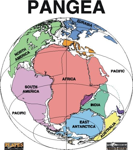
6 End Permian land and oceans Pangaea was shaped like a C Inside ocean: Tethys Sea Outside ocean: Panthalassa Panthalassa Panthalassa Tethys sea
7
8 Breakup of Pangea 1: Triple Junctions Seafloor spreading creates a triple junction: a point where 3 tectonic plates diverge North America split off from S America and Africa

9 Triple Junctions
10 Seafloor spreading raises sea level Seafloor spreading causes bulges in ocean basins Big enough bulges and/or lots of them lowers the ocean volume This can cause flooding of the continents.
11 Breakup of Pangaea 2: Opening of Gulf of Mexico In Middle Jurassic, North America and South America separated Gulf of Mexico began to open Restricted basin at first lots of evaporites deposited

12 Gulf of Mexico Salt

13 Paleogeography of the World During the Triassic Period

14 Paleogeography of the World During the Jurassic Period
15 Breakup of Pangaea 3: Continued Widening of North Atlantic In Late Cretaceous, Atlantic widened rapidly Canada and Europe separated
16 Final Breakup In Late Cretaceous, Australia and Antarctica separated In Cenozoic, Antarctica and South America separated

17 Paleogeography of the World During the Late Cretaceous Period

18 At the end of the Triassic, Pangea began to rift apart. The supercontinent of Pangea, mostly assembled by the Triassic, allowed land animals to migrate from the South Pole to the North Pole. Life began to rediversify after the great Permo-Triassic extinction and warm-water faunas spread across Tethys.
19 Pangea was assembled piece-wise. The continental collisions that lead to the formation of the supercontinent began in the Devonian and continued through the Late Triassic.
20 In a similar fashion, the supercontinent of Pangea did not rift apart all at once, but rather was subdivided into smaller continental blocks in three main episodes. The first episode of rifting began in the middle Jurassic, about 180 million years ago. After an episode of igneous activity along the east coast of North America and the northwest coast of Africa, the Central Atlantic Ocean opened as North America moved to the northwest. This movement also gave rise to the Gulf of Mexico as North America moved away from South America. At the same time, on the other side of Africa, extensive volcanic eruptions along the adjacent margins of east Africa, Antarctica, and Madagascar heralded the formation of the western Indian Ocean.
21 During the Mesozoic North America and Eurasia were one landmass, sometimes called Laurasia. As the Central Atlantic Ocean opened, Laurasia rotated clockwise, sending North America northward, and Eurasia southward. Coals, which were abundant in eastern Asia during the early Jurassic, were replaced by deserts and salt deposits during the Late Jurassic as Asia moved from the wet temperate belt to the dry subtropics. This clockwise, see-saw motion of Laurasia also lead to the closure of the wide V-shaped ocean, Tethys, that separated Laurasia from the fragmenting southern supercontinent, Gondwana.
22 By the Early Jurassic, south-central Asia had assembled. A wide Tethys ocean separated the northern continents from Gondwana. Although Pangea was intact, the first rumblings of continental break up could be heard.
23 The supercontinent of Pangea began to break apart in the Middle Jurassic. In the Late Jurassic the Central Atlantic Ocean was a narrow ocean separating Africa from eastern North America. Eastern Gondwana had begun to separate form Western Gondwana.

24 During the Cretaceous the South Atlantic Ocean opened. India separated from Madagascar and raced northward on a collision course with Eurasia. Notice that North America was connected to Europe, and that Australia was still joined to Antarctica.
25 The second phase in the breakup of Pangea began in the early Cretaceous, about 140 million years ago. Gondwana continued to fragment as South America separated from Africa opening the South Atlantic, and India together with Madagascar rifted away from Antarctica and the western margin of Australia opening the Eastern Indian Ocean. The South Atlantic did not open all at once, but rather progressively "unzipped" from south to north. That is why the South Atlantic is wider to the south.
26 Other important plate tectonic events occurred during the Cretaceous Period. These include: - the initiation of rifting between North America and Europe, - the counter-clockwise rotation of Iberia from France, - The separation of India from Madagascar, the derivation of Cuba and Hispaniola from the Pacific, - the uplift of the Rocky mountains, - and the arrival of exotic terranes (Wrangellia, Stikinia) along the western margin of North America.
27 Globally, the climate during the Cretaceous Period, like the Jurassic and Triassic, was much warmer than today. Dinosaurs and palm trees were present north of the Arctic Circle and in Antarctica and southern Australia. Though there may have been some at the poles during the Early Cretaceous, there were no large ice caps at anytime during the Mesozoic Era. These mild climatic conditions were in part due to the fact shallow seaways covered the continents during the Cretaceous. Warm water from the equatorial regions was also transported northward, warming the polar regions. These seaways also tended to make local climates milder, much like the modern Mediterranean Sea, which has an ameliorating effect on the climate of Europe.
28 Shallow seaways covered the continents because sea level was meters higher than today. Higher sea level was due, in part, to the creation of new rifts in the ocean basins that displaced water onto the continents. The Cretaceous was also a time of rapid sea-floor spreading. Because of their broad profile, rapidly spreading mid-ocean ridges displace more water than do slow spreading mid-ocean ridges. Consequently, during times of rapid sea-floor spreading, sea level will tend to rise.
29 50-55 million years ago India began to collide with Asia forming the Tibetan plateau and Himalayas. Australia, which was attached to Antarctica, began to move rapidly northward.

30 20 million years ago, Antarctica was coverd by ice and the northern continents were cooling rapidly. The world has taken on a "modern" look, but notice that Florida and parts of Asia were flooded by the sea.
.")
31 When the Earth is in its "Ice House" climate mode, there is ice at the poles. The polar ice sheet expands and contacts because of variations in the Earth's orbit (Milankovitch cycles). The last expansion of the polar ice sheets took place about 18,000 years ago.
32 Where did most North American mountain-building occur during Paleozoic?
33 Where did most North American mountain-building occur during Paleozoic? East Coast - Appalachians
34 Cordillera Orogenies General term refering to complex period of mountain-building Jurassic-Cenozoic Farallon plate goes below N American plate Nevadan orogeny Late Jurassic/Early Cretaceous Orogeny near the current W coast Slope of subducting Farallon plate decreased -> Sevier orogeny Late Cretaceous Further east (Utah) Laramide orogeny Late Cretaceous/Cenozoic Even FURTHER east! Rockies
35 Global Sea-Level Rise A global rise in sea level during the Cretaceous resulted in worldwide transgressions marine deposition was continuous over much of the North American Cordillera
36 Cretaceous Flood Worldwide transgression 1/3 of land area of Earth submerged 100 Ma Cretaceous Interior Seaway in North America

37 Cretaceous Interior Seaway Paleogeography of North America during the Cretaceous Period

38 Western Interior Seaway
39 The Effects on Global Climates and Ocean Circulation Patterns At the end of the Permian Period Pangaea extended from pole to pole Covered about one-fourth of Earth's surface Surrounded by a global ocean that encompassed about 300 degrees of longitude Such a configuration exerted tremendous influence on the world's climate resulted in generally arid conditions over large parts of Pangaea's interior
 with a single continent")
40 Oceanic Circulation Evolved From a simple pattern in a single ocean (Panthalassa) with a single continent (Pangaea)

41 Oceanic Circulation Evolved to a more complex pattern in the newly formed oceans of the Cretaceous Period
42 Areas Dominated by Seas Are Warmer Oceans absorb about 90% of the solar radiation they receive continents absorb only about 50% even less if they are snow covered The rest of the solar radiation is reflected back into space Therefore, areas dominated by seas are warmer than those dominated by continents
43 Mesozoic Tectonics (Key Events) Period North America Orogenies Cretaceous Jurassic Triassic Devonian Other Major Events Separation of India from Gondwanna Nevadan Orogeny (J-K) Sevier Orogeny (J-K) Opening of Atlantic Ocean Sonoma Orogeny (Triassic) Opening of Gulf of Mexico Antler Orogeny (Devonian)

44 Mesozoic Tectonics The separation of Gondwana and Laurentia began in the Triassic. Initial flooding of the Atlantic Ocean began in the Jurassic. This was the start of a new drift direction for North America; WNW
45 Mesozoic Tectonics Into the Triassic, many more terranes (mostly island arcs) began to be scooped up by North America as it drifted WNW
46 Mesozoic Tectonics Into the Triassic, many more terranes (mostly island arcs) began to be scooped up by North America as it drifted WNW Brooke Range Terrane (Alaska) Stikine Terrane (British Columbia) Sonoma Terrane (Nevada)
47 Mesozoic Tectonics Into the Triassic, many more terranes (mostly island arcs) began to be scooped up by North America as it drifted WNW Brooke Range Terrane (Alaska) Stikine Terrane (British Columbia) Sonoma Terrane (Nevada)

48 Mesozoic Tectonics The Sonoman Orogeny in the Triassic marks the start of the formation of the Cordilleran Mountains and the current active margin Mid-Triassic Paleogeography (source
 Major (felsic) intrusions begin")
49 Mesozoic Tectonics In the Jurassic, we start to see terranes with mixed lithologies docking with North America (e.g., Klamath Terrane) Major (felsic) intrusions begin

50 Mesozoic Tectonics The culmination of several hits and docking events as well as major phases of felsic intrusions is collectively called the Nevadan Orogeny Mid-Jurassic Paleogeography (source

51 Mesozoic Tectonics In the Cretaceous, more hits and more intrusions. More uplift Wrangellia Terrane docks

52 Mesozoic Tectonics The culmination of several hits and docking events from the Jurassic to the Cretaceous produced major phases of thrust faulting and is collectively called the Sevier Orogeny Early Cretaceous Paleogeography (source


53 Mesozoic Paleogeography Most continents were isolated Seas opened: South Atlantic; Gulf of Mexico; Caribbean Sea Mid-Cretaceous sea level high Tethys Seaway

54 Mesozoic Climate Wind belt Evaporite deposition


55 Mesozoic Climate High latitudes were warm 50 F / 10 C Dinosaurs near south pole

56 Mesozoic Climate Period of high sea level Associated with rapid sea floor spreading Long period without reversal

57 Mesozoic Climate Oceans stagnated Epicontinental black muds when seas spilled over Normally thin oxygen poor zone expanded This will change in the early Cenozoic (Late Eocene)

58 Cenozoic Climate Oxygen isotopes Late Eocene cooling Deep sea foraminifera
59 Cenozoic Climate Paleocene-Middle Eocene: No circumpolar current Late Eocene-today: Circumpolar current Permitted development of glaciers on Antarctica

60 Cenozoic Climate
61 Cenozoic Tectonic Events Final breakup of Gondwana (Australia separated from Antarctica in the Latest Paleocene earliest Eocene epochs) India began to collide with Asia forming the Himalayan Mountain Range (Oligocene to Recent) Africa started to shift northward, gradually sliding under Europe and uplifting the Alps (Oligocene to Recent) Continued westward movement of North America and South America formed an on again off again land bridge between the two continents. This gave rise to some interesting animal exchanges. North American orogenies become dominated by strike-slip faulting and uplift. Mountain building in the northern part of the Cordilleran mountains (mostly Canada) slows down stop during the Oligocene. Activity shifts to the southern part of the mountain chain (Colorado, Nevada etc.). Major late Tertiary flood basalt eruptions occur in Oregon and Washington state. Hot spot volcanism occurs in the area of Yellowstone (Pliocene to present). Composite volcanic eruptions (some incredibly explosive) periodically occurred and still do (e.g., Mt St Helen s).

62 Himalayan Mountains Indian craton collided with Eurasia
Quiz 12 Bonus 2 (9:30-9:35 AM)
") Quiz 12 Bonus 2 (9:30-9:35 AM) UNIVERSITY OF SOUTH ALABAMA GY 112: Earth History Lectures 32 and 33: Mesozoic Sedimentation Instructor: Dr. Douglas W. Haywick Last Time Mesozoic Tectonics A) The Triassic
Quiz 12 Bonus 2 (9:30-9:35 AM) UNIVERSITY OF SOUTH ALABAMA GY 112: Earth History Lectures 32 and 33: Mesozoic Sedimentation Instructor: Dr. Douglas W. Haywick Last Time Mesozoic Tectonics A) The Triassic
GY 112: Earth History
 UNIVERSITY OF SOUTH ALABAMA GY 112: Earth History Lectures 31: Mesozoic Tectonics Instructor: Dr. Douglas W. Haywick Last Time Mesozoic Overview A) The end of the Paleozoic B) Mesozoic time frame and evolutionary
Mesozoic Earth History
 Mesozoic Earth History The Mesozoic Era 251-66 MYA Breakup of Pangea Changes in air and oceanic currents Evolution of new terrestrial and marine life Opening of the Atlantic Ocean Basin Rocky Mountains
In the space provided, write the letter of the definition that best matches the term or phrase.
 Skills Worksheet Directed Reading Section: The Changing Continents 1. What is the result of slow movements of tectonic plates? RESHAPING EARTH S CRUST In the space provided, write the letter of the definition
The Mesozoic. Wednesday, November 30, 11
 The Mesozoic Periods of the Mesozoic Triassic- First period of the Mesozoic era Jurassic Cretaceous- Last period of the Mesozoic era Breakup of Pangaea Stage one (Triassic) Rifting and volcanism, normal
Phanerozoic (last 0.54 by) Tectonics Climate Life
 Tectonics Climate Life") Phanerozoic (last 0.54 by) Tectonics Climate Life Tools for Locating Past Continent Positions Fossils depending on climate Alignment of geological features Geometrical fit of continental margins Similarity
Phanerozoic (last 0.54 by) Tectonics Climate Life Tools for Locating Past Continent Positions Fossils depending on climate Alignment of geological features Geometrical fit of continental margins Similarity
Name Class Date. In the space provided, write the letter of the definition that best matches the term or phrase.
 Skills Worksheet Directed Reading Section: The Changing Continents 1. What is the result of slow movements of tectonic plates? RESHAPING EARTH S CRUST In the space provided, write the letter of the definition
Plio-Pleistocene Geology
 UNIVERSITY OF SOUTH ALABAMA GY 112: Earth History Plio-Pleistocene Geology Instructor: Dr. Douglas W. Haywick Last Time A) Cenozoic Tectonics Western North American tectonic provinces Plateaus and canyons
Copyright McGraw-Hill Education. All rights reserved. No reproduction or distribution without the prior written consent of McGraw-Hill Education
 Copyright McGraw-Hill Education. All rights reserved. No reproduction or distribution without the prior written consent of McGraw-Hill Education Tibetan Plateau and Himalaya -southern Asia 11.00.a VE 10X
3. The diagram below shows how scientists think some of Earth's continents were joined together in the geologic past.
 1. The map below shows the present-day locations of South America and Africa. Remains of Mesosaurus, an extinct freshwater reptile, have been found in similarly aged bedrock formed from lake sediments
Plate Tectonic Vocabulary Chapter 10 Pages
 Name: Period: Plate Tectonic Vocabulary Chapter 10 Pages 239-260 Vocabulary Word What is this? What are some examples? What does it look like? (draw a picture or diagram) Continental drift Mid-ocean ridge
Last Time. Submarine Canyons and Fans. Turbidites. MAS 603: Geological Oceanography. Lecture 16: Greenhouse vs. Icehouse Earths
 UNIVERSITY OF SOUTH ALABAMA Last Time MAS 603: Geological Oceanography Lecture 16: Greenhouse vs. Icehouse Earths Submarine Fans Definition and morphology Transport mechanisms (density currents) Submarine
Plate Tectonics. Essentials of Geology, 11 th edition Chapter 15
 1 Plate Tectonics Essentials of Geology, 11 th edition Chapter 15 2 3 4 5 6 7 8 9 10 11 12 13 14 15 Plate Tectonics: summary in haiku form Alfred Wegener gave us Continental Drift. Fifty years later...
Directed Reading. Section: Continental Drift. years ago? WEGENER S HYPOTHESIS
 Skills Worksheet Directed Reading Section: Continental Drift 1. Who obtained new information about the continents and their coastlines 400 years ago? 2. What did people notice when they studied new world
Continental drift
 Plate Tectonics Continental drift Continental drift Continental drift Continental drift Continental drift Plate Tectonics Plate Tectonics Continental Drift and Paleomagnetism Paleomagnetism Renewed interest
Section 1: Continental Drift
 Plate Tectonics Section 1 Section 1: Continental Drift Preview Key Ideas Wegener s Hypothesis Sea-Floor Spreading Paleomagnetism Wegener Redeemed Continental Drift (Pangaea) Plate Tectonics Section 1 Key
UNIVERSITY OF SOUTH ALABAMA. GY 112: Earth History. Lecture 36: Plio-Pleistocene Geology. Instructor: Dr. Douglas W. Haywick
 UNIVERSITY OF SOUTH ALABAMA GY 112: Earth History Lecture 36: Plio-Pleistocene Geology Instructor: Dr. Douglas W. Haywick Last Time A) Cenozoic Overview and Tectonics Western North American tectonic provinces
Introduction to Oceanography. Chapter 2: Plate Tectonics Overview
 Introduction to Oceanography Chapter 2: Plate Tectonics Overview Much evidence supports plate tectonics theory. The plate tectonics model describes features and processes on Earth. Plate tectonic science
Cenozoic: Global Events Ma- Present
 Cenozoic: Global Events 65.5 Ma- Present Major Tectonic Events The Rise of the Himalayas and Closure of the Tethyan Ocean Caused Climate Change Equatorial Ocean Closed Rifting in Western North America
Refer to the map on page 173 to answer the following questions.
 Chapter 8-1 Plate Tectonics 1. Brainstorm the type of evidence that would indicate a climate change and how this evidence supports the theory of continental drift. Tropical fossils in cold regions Evidence
Earth s Changing Continents
 2 What You Will Learn Earth s continents have moved around Earth s surface throughout Earth s history and have only recently arrived at their current locations. Rocks and fossils provide evidence of continental
Pangaea to the Present Lesson #2
 Pangaea to the Present Lesson #2 The Earth is a dynamic or constantly changing planet. The thin, fragile plates slide very slowly on the mantle's upper layer. This sliding of the plates is caused by the
Alfred Wegener gave us Continental Drift. Fifty years later...
 CHAPTER 2 Plate Tectonics and the Ocean Floor Plate Tectonics: summary in haiku form Alfred Wegener gave us Continental Drift. Fifty years later... Words Chapter Overview Much evidence supports plate tectonics
Directed Reading. Section: How Mountains Form MOUNTAIN RANGES AND SYSTEMS. Skills Worksheet
 Skills Worksheet Directed Reading Section: How Mountains Form 1. How high is Mount Everest? a. about 1980 km above sea level b. more than 8 km below sea level c. more than 8 km above sea level d. more
The Lithosphere and the Tectonic System. The Structure of the Earth. Temperature 3000º ºC. Mantle
 The Lithosphere and the Tectonic System Objectives: Understand the structure of the planet Earth Review the geologic timescale as a point of reference for the history of the Earth Examine the major relief
Essentials of Oceanography Eleventh Edition
 Chapter Chapter 1 2 Clickers Lecture Essentials of Oceanography Eleventh Edition Plate Tectonics and the Ocean Floor Alan P. Trujillo Harold V. Thurman Chapter Overview Much evidence supports plate tectonics
Ch. 17 Review. Life in the Cretaceous
 Ch. 17 Review Life in the Cretaceous Diversification of diatoms, planktonic forams, calcareous nannoplankton Diversification of mobile predators (especially mollusks and teleost fishes) Origin of the angiosperms
Chapter. Graphics by Tasa Graphic Arts. Inc.
 Earth Chapter Plate Science 9 Tectonics Graphics by Tasa Graphic Arts. Inc. 1 I. Earth s surface is made up of lithospheric plates. A. Lithospheric plates are composed of the crust and part of the upper
Plate Tectonics. 1)The plate tectonic system 2)A theory is born 3) Early evidence for continental drift 4) Continental drift and paleomagnetism
The plate tectonic system 2)A theory is born 3) Early evidence for continental drift 4) Continental drift and paleomagnetism") Plate Tectonics Plate boundaries 1)The plate tectonic system 2)A theory is born 3) Early evidence for continental drift 4) Continental drift and paleomagnetism 6)History and future of plate motions system
Plate Tectonics Plate boundaries 1)The plate tectonic system 2)A theory is born 3) Early evidence for continental drift 4) Continental drift and paleomagnetism 6)History and future of plate motions system
12/3/2014. Plate Tectonics: A Scientific Revolution Unfolds Earth Science, 13e Chapter 7. Continental drift: an idea before its time
 Plate Tectonics: A Scientific Revolution Unfolds Earth Science, 13e Chapter 7 Stanley C. Hatfield Southwestern Illinois College Continental drift: an idea before its time Alfred Wegener First proposed
USU 1360 TECTONICS / PROCESSES
 USU 1360 TECTONICS / PROCESSES Observe the world map and each enlargement Pacific Northwest Tibet South America Japan 03.00.a1 South Atlantic Arabian Peninsula Observe features near the Pacific Northwest
Plate Tectonics GEOL 101 Lecture 22 How Are Mountains Built?
 Plate Tectonics GEOL 101 Lecture 22 How Are Mountains Built? The Grand Tetons, Wyoming First a Brief Review of Sea Floor Spreading Prop: Test 3 Invitations Break-Up of a Continent and Origin of an Ocean
Chapter 7 Plate Tectonics. Plate tectonics accounts for important features of Earth s surface and major geologic events.
 Chapter 7 Plate Tectonics Plate tectonics accounts for important features of Earth s surface and major geologic events. 7-2 Alfred Wegener s Hypothesis of Continental Drift (1915) He noticed that the continents
Unit 4 Lesson 2 Plate Tectonics. Copyright Houghton Mifflin Harcourt Publishing Company
 Puzzling Evidence What evidence suggests that continents move? In the late 1800s, Alfred Wegener proposed his hypothesis of continental drift. According to this hypothesis, the continents once formed a
PHYSICAL GEOLOGY AND THE ENVIRONMENT (2 ND CANADIAN EDITION)
") Chapter 2: Plate Tectonics Chapter Summary: Plate tectonics is a theory that suggests Earth's surface is divided into several large plates that change position and size. Intense geologic activity occurs
Chapter 2: Plate Tectonics Chapter Summary: Plate tectonics is a theory that suggests Earth's surface is divided into several large plates that change position and size. Intense geologic activity occurs
Chapter Overview. Evidence for Continental Drift. Plate Tectonics. Evidence for Continental Drift. Evidence for Continental Drift 9/28/2010
 Chapter Overview CHAPTER 2 Plate Tectonics and the Ocean Floor Much evidence supports plate tectonics theory. Different plate boundaries have different features. Tectonic plates continue to move today.
The surface of the ocean floor is as varied as the land. The five major oceans, from largest to smallest, are
 11.1 Ocean Basins The surface of the ocean floor is as varied as the land. The five major oceans, from largest to smallest, are w the Pacific w the Atlantic w the Indian w the Southern w the Arctic The
Geologic Time. What have scientists learned about Earth s past by studying rocks and fossils?
 Name Geologic Time What have scientists learned about Earth s past by studying rocks and fossils? Before You Read Before you read the chapter, think about what you know about geologic time Record your
Plate Tectonics Practice Test
 Plate Tectonics Practice Test 1. What is the main idea Alfred Wegner proposed in the Theory of Continental Drift that he published in 1915? a. The continents float on a liquid layer that allows them to
Chapter Two. Figure 02_02. Geography of the Ocean Basins. The Sea Floor
 Chapter Two The Sea Floor Geography of the Ocean Basins Figure 02_02 The world ocean is the predominant feature on the Earth in total area. In the Northern Hemisphere, 61% of the total area is ocean. In
60% water. Big Bang: 14,000 millions years ago The Earth originated about 4,500 millions years ago its orbit allows water to exist in a liquid state!
 Ch2. The Sea Floor #1 Why geology of the oceans? Marine habitats are directly shaped by geological processes The form of the coastlines The depth of the water Type of bottom (muddy, sandy, rocky) #2 Geological
Movement of the Earth s Crust: Formation of: Mountain s Plateau's and Dome s
 Movement of the Earth s Crust: Formation of: Mountain s Plateau's and Dome s References Information taken from several places including Prentice Hall Earth Science: @ http://www.eram.k12.ny.us/education/components/docmgr/default.php?sectiondetaili
Unit 5 Possible Test Questions Mesozoic and Cenozoic Eras HISTORICAL GEOLOGY
 Revised 8/16 Unit 5 Possible Test Questions Mesozoic and Cenozoic Eras HISTORICAL GEOLOGY Mesozoic Era Eons, Eras and Periods 1. List the Mesozoic periods in order (oldest to youngest). End of the Paleozoic
Plate Tectonics CHAPTER 17
 Plate Tectonics CHAPTER 17 Layers of the Earth A. Crust- solid, 5-70 km thick Moho Two Types of Crust: Oceanic- ocean floor, more dense then because of more iron Continental-dry land (mostly silicates
Physical Geology, 15/e
 Lecture Outlines Physical Geology, 15/e Plummer, Carlson & Hammersley Plate Tectonics: The Unifying Theory Physical Geology 15/e, Chapter 19 Plate Tectonics Plate Tectonics Earth s surface is composed
Section 1: How Did Life Begin? Chapter 19: History of Life on Earth. Section 2: The Age of Earth
 Chapter 19: History of Life on Earth Section 1: How Did Life Begin? I. The Basic Chemicals of Life A. 1920s B. Earth s early oceans contained large amounts of organic molecules C. Molecules formed spontaneously
PLATE TECTONICS THEORY
 PLATE TECTONICS THEORY Continental drift Sea floor spreading CONTINENTAL DRIFT CONTINENTAL DRIFT 1. The fitness of continents and Continental Reconstruction Earth ~200 million years ago 1.1 Geometrical
Tropical Moist Rainforest
 Tropical or Lowlatitude Climates: Controlled by equatorial tropical air masses Tropical Moist Rainforest Rainfall is heavy in all months - more than 250 cm. (100 in.). Common temperatures of 27 C (80 F)
UNIT 6 PLATE TECTONICS
 UNIT 6 PLATE TECTONICS CONTINENTAL DRIFT Alfred Wegner proposed the theory that the crustal plates are moving over the mantle. He argued that today s continents once formed a single landmass, called Pangaea
Chapter 2 Plate Tectonics and the Ocean Floor
 Chapter 2 Plate Tectonics and the Ocean Floor Chapter Overview Much evidence supports plate tectonics theory. The plate tectonics model describes features and processes on Earth. Plate tectonic science
Continental Drift and Plate Tectonics
 Continental Drift and Plate Tectonics As you work through the following slides of information, make sure you use the information to complete the tasks on your worksheet. By the end of the PDF, you should
Plate Tectonics. And Plate Boundaries HORRAH!!!
 Plate Tectonics And Plate Boundaries HORRAH!!! History of Plate Tectonics and Alfred Wegener In the 1500 s, a Dutch mapmaker, Abraham Ortelius noticed the continents across the Atlantic Ocean fit like
Earth s Evolution Through Time
 1 2 3 4 5 6 7 8 9 10 11 12 13 14 Earth s Evolution Through Time Earth 9 th edition Chapter 22 Earth s evolution: summary in haiku form Super-continents have come and gone many times: giant bumper cars.
The Sea Floor. Chapter 2
 The Sea Floor Chapter 2 Geography of the Ocean Basins World ocean is the predominant feature on the Earth in total area Northern Hemisphere = 61% of the total area is ocean. Southern Hemisphere = about
Week: 4 5 Dates: 9/8 9/12 Unit: Plate Tectonics
 clementaged.weebly.com Name: ODD Period: Week: 4 5 Dates: 9/8 9/12 Unit: Plate Tectonics Monday Tuesday Wednesday Thursday Friday 7 No School 8 E 9 O *Vocabulary *Frayer Vocab *Continental Drift Notes
Prentice Hall EARTH SCIENCE
 Prentice Hall EARTH SCIENCE Tarbuck Lutgens Chapter 9 Plate Tectonics 9.1 Continental Drift An Idea Before Its Time Wegener s continental drift hypothesis stated that the continents had once been joined
Prentice Hall EARTH SCIENCE
 Prentice Hall EARTH SCIENCE Tarbuck Lutgens Chapter 9 Plate Tectonics 9.1 Continental Drift An Idea Before Its Time Wegener s continental drift hypothesis stated that the continents had once been joined
Plate Tectonics. Earth has distinctive layers - Like an onion
 Plate Tectonics Earth has distinctive layers - Like an onion Earth s Interior Core: Metallic (Iron, Nickel) Inner (hot, solid, dense, Iron, Nickel) Outer (cooler, liquid, less dense) Crust (outermost layer):
Chapter 02 The Sea Floor
 Chapter 02 The Sea Floor Multiple Choice Questions 1. One of the following is not one of the world's major ocean basins: A. Atlantic Ocean B. Arctic Ocean C. Indian Ocean D. Antarctic Ocean E. Pacific
1. I can describe evidence for continental drift theory (e.g., fossil evidence, mountain belts, paleoglaciation)
") Science 10 Review Earth Science Vocabulary asthenosphere continental drift theory converging plates diverging plates earthquakes epicentre fault hot spot inner core lithosphere mantle mantle convection
Science 10 Review Earth Science Vocabulary asthenosphere continental drift theory converging plates diverging plates earthquakes epicentre fault hot spot inner core lithosphere mantle mantle convection
Geologic Time. The Cenozoic Era. 7. Mammals evolved after dinosaurs became extinct.
 Geologic Time The Cenozoic Era Key Concepts What major geologic events occurred during the Cenozoic era? What does fossil evidence reveal about the Cenozoic era? What do you think? Read the two statements
12. The diagram below shows the collision of an oceanic plate and a continental plate.
 Review 1. Base your answer to the following question on the cross section below, which shows the boundary between two lithospheric plates. Point X is a location in the continental lithosphere. The depth
Science 10 PROVINCIAL EXAM STUDY BOOKLET. Unit 4. Earth Science
 Science 10 PROVNCAL EXAM STUDY BOOKLET Unit 4 Earth Science Student nstructions 1. Ensure that you have blank paper and a Data Booklet. 2. Record all answers on a separate piece of paper. 3. Answer keys
I. Earth s Layers a. Crust: Earth s outside layer. Made of mostly rock. i. Continental: er; made of mostly granite, forms the continents and shallow
 I. Earth s Layers a. Crust: Earth s outside layer. Made of mostly rock. i. Continental: er; made of mostly granite, forms the continents and shallow sea beds, floats! ii. Oceanic: er; dense rock such as
Beneath our Feet: The 4 Layers of the Earty by Kelly Hashway
 Beneath our Feet: The 4 Layers of the Earty by Kelly Hashway The Earth is more than a giant ball made up of dirt, rocks, and minerals. The Earth may look like a giant ball from when looking at it from
5. Convergent boundaries produce a relatively low number of earthquakes compared to other boundaries. a. True
 1. Earth s crust is thinner than its mantle. ANSWER: True 2. The concept of isostacy states that high-density rock will stand higher than low-density rock, which explains the formation of subduction zones.
Chapter 1 Section 2. Land, Water, and Climate
 Chapter 1 Section 2 Land, Water, and Climate Vocabulary 1. Landforms- natural features of the Earth s land surface 2. Elevation- height above sea level 3. Relief- changes in height 4. Core- most inner
4 Changes in Climate. TAKE A LOOK 2. Explain Why is more land exposed during glacial periods than at other times?
 Name Class CHAPTER 3 Date Climate 4 Changes in Climate SECTION National Science Education Standards BEFORE YOU READ After you read this section, you should be able to answer these questions: ES 1k, 2a
Ch 9.1 Notes. Objective: Be able to explain the theory of plate tectonics and be able to explain evidence that supports it.
 Ch 9.1 Notes Objective: Be able to explain the theory of plate tectonics and be able to explain evidence that supports it. Pangaea Alfred Wegener proposed that land on Earth formed a single, huge landmass.
Fig Major air masses of the world
 Fig. 9.3 Major air masses of the world CLASSIFICATION FOUR BASIC CATEGORIES OF AIR MASSES: POLAR - P ARCTIC - A TROPICAL - T EQUATORIAL - E TWO DESIGNATIONS OF SURFACE IN SOURCE REGION MARITIME - m. CONTINENTAL
Chapter 2 Plate Tectonics and the Ocean Floor
 Chapter 2 Plate Tectonics and the Ocean Floor Matching. Match the term or person with the appropriate phrase. You may use each answer once, more than once or not at all. 1. hydrothermal vents A. convergent
Introduction To Plate Tectonics Evolution. (Continents, Ocean Basins, Mountains and Continental Margins)
") Introduction To Plate Tectonics Evolution (Continents, Ocean Basins, Mountains and Continental Margins) Geo 386 (Arabian Shield Course) Dr. Bassam A. A. Abuamarah Mohanna G E O 3 8 6 A R A B I A N G E
Introduction To Plate Tectonics Evolution (Continents, Ocean Basins, Mountains and Continental Margins) Geo 386 (Arabian Shield Course) Dr. Bassam A. A. Abuamarah Mohanna G E O 3 8 6 A R A B I A N G E
Practice Questions: Plate Tectonics
 Practice Questions: Plate Tectonics 1. Base your answer to the following question on The block diagram below shows the boundary between two tectonic plates. Which type of plate boundary is shown? A) divergent
Chapter 4: Plate Tectonics
 Chapter 4: Plate Tectonics K2 in the Himalaya, inset round submersible (beneath the submarine) that went to the Marianas Trench in 1960 http://www.nydailynews.com/news/world/james-cameron-presents-record-setting-deep-sea-expedition-article-1.1215139
11 Plate Tectonics Abridged. Japan GEOG /10/2013. Instructor: Pesses 1. Part III Earth s Changing Landscapes
 11 Plate Tectonics Abridged Part III Earth s Changing Landscapes Geography 101 Physical Geography: Earth s Surface Landscapes M. Pesses, Antelope Valley College Japan Pictures provided by Prof. Lori Dengler,
Plate Tectonics. In 1912 Alfred Wegener ( ) proposed that: the continents were once compressed into a single protocontinent which he called
 proposed that: the continents were once compressed into a single protocontinent which he called") Plate Tectonics In 1912 Alfred Wegener (1880-1930) proposed that: the continents were once compressed into a single protocontinent which he called Pangaea (meaning "all lands"), and over time they have
Plate Tectonics In 1912 Alfred Wegener (1880-1930) proposed that: the continents were once compressed into a single protocontinent which he called Pangaea (meaning "all lands"), and over time they have
PLATE TECTONICS. Continental Drift. Continental Drift. Continental Drift. Continental Drift- Wegener s Evidence
 Continental Drift PLATE TECTONICS E.B. Taylor (1910) and Alfred Wegener (1915) published on Continental Drift. Continental Drift Wegener s evidence 1. Fit of the Continents 2. Fossil Evidence 3. Rock Type
Plate Tectonics. By Destiny, Jarrek, Kaidence, and Autumn
 Plate Tectonics By Destiny, Jarrek, Kaidence, and Autumn .The Denali Fault and San Andreas Fault - The San Andreas Fault is a continental transform fault that extends roughly 1300 km (810 miles) through
A) B) C) D) 4. Which diagram below best represents the pattern of magnetic orientation in the seafloor on the west (left) side of the ocean ridge?
 B) C) D) 4. Which diagram below best represents the pattern of magnetic orientation in the seafloor on the west (left) side of the ocean ridge?") 1. Crustal formation, which may cause the widening of an ocean, is most likely occurring at the boundary between the A) African Plate and the Eurasian Plate B) Pacific Plate and the Philippine Plate C)
1. Crustal formation, which may cause the widening of an ocean, is most likely occurring at the boundary between the A) African Plate and the Eurasian Plate B) Pacific Plate and the Philippine Plate C)
Lecture Outlines PowerPoint. Chapter 12 Earth Science 11e Tarbuck/Lutgens
 Lecture Outlines PowerPoint Chapter 12 Earth Science 11e Tarbuck/Lutgens 2006 Pearson Prentice Hall This work is protected by United States copyright laws and is provided solely for the use of instructors
PLATE TECTONICS. SECTION 17.1 Drifting Continents
 Date Period Name PLATE TECTONICS SECTION.1 Drifting Continents In your textbook, read about continental drift. Circle the letter of the choice that best completes each statement. 1. Early mapmakers thought
How do glaciers form?
 Glaciers What is a Glacier? A large mass of moving ice that exists year round is called a glacier. Glaciers are formed when snowfall exceeds snow melt year after year Snow and ice remain on the ground
SUBSURFACE CHANGES TO EARTH. Ms. Winkle
 SUBSURFACE CHANGES TO EARTH Ms. Winkle OVERVIEW Subsurface events: occurring inside the crust and mantle Moving the lithosphere due to the convection currents in the asthenosphere Main Theories: 1912 Wegener,
5/24/2018. Plate Tectonics. A Scientific Revolution Unfolds
 1 Plate Tectonics A Scientific Revolution Unfolds 2 3 4 5 6 7 8 9 10 11 12 Chapter 2 Plate Tectonics From Continental Drift to Plate Tectonics Prior to the late 1960s, most geologists believed that the
Continental Drift. & Plate Tectonics
 Continental Drift & Plate Tectonics Alfred Wegener, a German scientist, proposed the hypothesis of CONTINENTAL DRIFT, in 1912. Hypothesis stated: All Earth s continents were once a single landmass (Pangaea)
deep within the planet. They are also shaped by conditions on the planet s surface. In
 Chapter 4 Landforms, Water, and Natural Resources Earth is home to many different types of landforms. These landforms are shaped by forces deep within the planet. They are also shaped by conditions on
Lithospheric plates. Geology of the Batemans Bay region. Tectonic processes
 1 Lithospheric plates Enormous heat sources in the Earth s deep interior, acquired during the very early history of the planet billions of years ago continue to drive present-day geological at the surface.
24. Ocean Basins p
 24. Ocean Basins p. 350-372 Background The majority of the planet is covered by ocean- about %. So the majority of the Earth s crust is. This crust is hidden from view beneath the water so it is not as
Before Plate Tectonics: Theory of Continental Drift
 Before Plate Tectonics: Theory of Continental Drift Predecessor to modern plate tectonics Shape and fit of the continents was the initial evidence Snider-Pelligrini (1858) Taylor (1908) Wegner (1915) Fig.
Plate Tectonics: A Unifying Theory
 Plate Tectonics: A Unifying Theory What is Plate Tectonics? - 7 large tectonic plates and many smaller ones that break up the lithosphere - Plates are brittle and float on asthenosphere and glide past
Grand Unifying Theory of everything... for the Geosciences, at least!
 Plate Tectonics: Grand Unifying Theory of everything... for the Geosciences, at least! The Earth s lithosphere, composed of Oceanic and continental crust, is broken up into pieces that move and interact
Plate Tectonic Theory
 Have you ever looked at a world map and noticed the shapes of the continents? Have you ever noticed how some continents appear to fit together like the pieces of a jigsaw puzzle? Why do you think this
Continental Drift. Wegener theory that the crustal plates are moving and once were a super continent called Pangaea.
 PLATE TECTONICS WHAT IS TECTONICS? Tectonism is the faulting or folding or other deformation of the outer layer of a planet. It happens very slowly, on the scale of millions of years. Tectonic activity
Spring th Grade
 Spring 2015 8 th Grade The geologic time scale is a record of the major events and diversity of life forms present in Earth s history. The geologic time scale began when Earth was formed and goes on until
6. In the diagram below, letters A and B represent locations near the edge of a continent.
 1. Base your answer to the following question on the cross section below and on your knowledge of Earth science. The cross section represents the distance and age of ocean-floor bedrock found on both sides
Drifting Continents and Spreading Seas. The Road To Plate Tectonics
 Drifting Continents and Spreading Seas The Road To Plate Tectonics Alfred Wegener and the Continental Drift hypothesis: Up until the early 1900s, long-held tradition in the earth sciences stated that continents
Evolution of Continents Chapter 20
 Evolution of Continents Chapter 20 Does not contain complete lecture notes. Mountain belts Orogenesis the processes that collectively produce a mountain belt Includes folding, thrust faulting, metamorphism,
What Are Tectonic Plates?
 Plate Tectonics The theory that the Earth s outermost layer is fragmented into a dozen or more large and small plates that move relative to one another as they ride on top of hotter, more mobile material.
Chapter Nineteen: Changing Earth
 Chapter Nineteen: Changing Earth 19.1 Inside Earth 19.2 Plate Tectonics 19.3 Plate Boundaries 19.4 Metamorphic Rocks 19.2 Learning Goals Discuss hypotheses which ultimately led to plate tectonics theory.
KS3 Russia: teacher notes lesson one. Map annotation exercise. What are the essentials of a good map?
 KS3 Russia: teacher notes lesson one Map annotation exercise What are the essentials of a good map? North arrow scale latitude and longitude, where applicable major landscape features such as the Urals