Depositional model and allostratigraphic architecture of Late Ordovician syn-glacial strata from the Tiguentourine Field (Illizi Basin, Algeria)
|
|
|
- Malcolm Todd
- 6 years ago
- Views:
Transcription
1 Depositional model and allostratigraphic architecture of Late Ordovician syn-glacial strata from the Tiguentourine Field (Illizi Basin, Algeria) By Stephane Roussé 2, Stig E. Sandvik 1, Bruno Murat 2, Alasdair Hutchinson 1, Kamel Saadi 1, Erwan Le Guerroué 2 1 BP/STATOIL/SONATRACH, In Amenas Joint Venture, BP 513, Hassi Messaoud 30500, Wilaya de Ourgla, Algerie 2 BEICIP-FRANLAB, E&P Consultancy, 232 Av. Napoléon Bonaparte, Rueil Malmaison, France. Corresponding autor:stephane.rousse@beicip.com Setting The Tiguentourine field (Illizi Basin, Algeria; Figure 1) holds gas condensate reserves within pre-glacial Cambrian sediments (fluvial to shallow marine), and syn-glacial late Ordovician sediments (C040 glaciogenic and C050 post-glacial shallow marine). At the scale of North-Gondwana platform, the Late Ordovician glacial episode led to an extensive icesheet growth. Ice-sheets development implied glacially-cut topographies (e.g. dug into pre-glacial substrate) ranging in scale from 100 km wide mega-valleys, to 10 km wide (palaeo-valleys and/or tunnel valleys). The lack of biostratigraphic constrains and the low resolution of the available seismic data set also strongly limits the layering of the syn-glacial reservoir. However the stratigraphy records a number of glacial erosion surfaces, sub-seismic in scale, strongly complicating the sedimentology of the syn-glacial deposits that bears the bulk of the gas reserves. In the light of a detailed sedimentological analysis performed on 22 cored wells, a depositional model of the syn-glacial succession was build. Allostratigraphic concepts have been applied to resolve part of the stratigraphic complexity and offer guide-lines for further geological modeling.
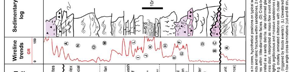
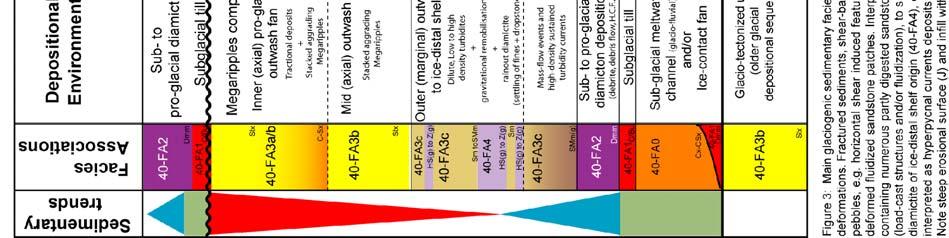
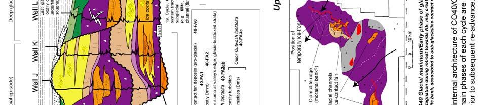
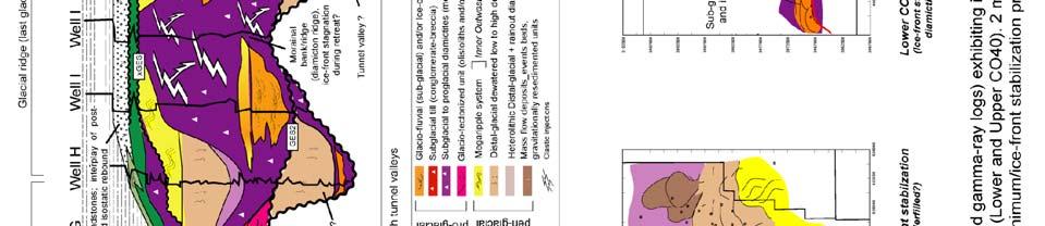
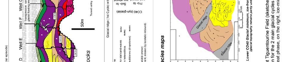
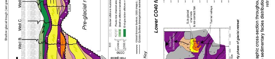
2 Subglacial topography in the Tiguentourine Field The isochore of the syn-glacial strata (Figure 2) underlined by well penetrations and seismic survey exhibits two elongate sub-parallel depositional thicks, trending approximately SE to NW and separated by a high (ridge). The troughs are inferred to be glacially-cut palaeo-valleys and filled by an overthickened CO40 unit reaching 250 m of thickness whereas the ridge exhibits a reduced syn-glacial series of less than a 100 m. However, it is to stress that isochore maps amalgamate multiple, stacked glacial cycles. Sedimentology of CO40 glacial deposits A glacial depositional sequence may be defined as a group of strata, bounded at top and base by two glacial erosion surfaces (GES) (Ghienne et al., 2008). As a consequence, a glacial depositional sequence (GS) is the record of a single glacial phase (e.g. a simple ice advance and subsequent retreat) where deposition mainly occurs during ice-sheet/ice-stream retreat. Based on cored intervals observations, an idealized suite of glaciogenic facies can be defined between two successive GES (Figure 3). Conceptually, this complete facies suite evolves from subglacial environments to pro-glacial and/or to peri-glacial settings.
3

.")
.")

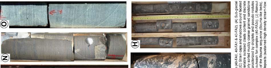
4 The recognition of glacially-driven deformation processes below GES (Figure 3A) such as shear structures, folding, fracturing (hydraulically induced) as well as associated clastic material injections within fractured network, is critical for GES interpretation and subsequent GES recognition in cored wells. Above an identified GES, the typical glaciogenic, vertical facies suite may be described as follow: At base, glacial-tractional sandy deposits (40-FA0, Figure 4) may be found incased in pre-glacial strata, older glacial sequences, and/or in coeval sub-to pro-glacial diamictites (inferred therefore as tillite and/or proglacial diamicton). The glacio-tractional deposits are typically made of cross-bedded to massive gravel sandstones (Figure 3D) and are interpreted to be deposited within narrow elongated meltwater channels (anastomozed fluvio-glacial channels network). At the immediate subaqueous outlet of the subglacial drainage system, sustained high-density flow deposits (megaripples and turbidites) may be associated. These deposits testify for an ice-contact fan occurrence, constructed by jet efflux streams, resting as fan-shaped sand body. In absence of the above-described facies-association, and/or above it, a blanket of subglacial «till» deposits (40-FA1, Figures 3 & 4), which corresponds to breccia-conglomerate and/or clast-rich diamictites, may be found. Intense deformation due to glacial drag is generally associated within and below the tillite layer, attesting of sub-glacial stressed conditions.
5 Above and/or grading upward from the tillite, sub-glacial to pro-glacial subaqueous diamictons (40- FA2, Figures 3E & 4) are deposited. These facies types often consist of mud-prone thick successions and their deposition may be related to a wide range of depositional processes and associated deformation structures. Deformation is mainly represented by fractures, folding, and clastic material injections within hydraulically induced fracture network (Figure 3F&G). All these arguments attest of pressurized depositional environment and argue for a moraine deposition in immediate front of icebody (marine-terminating ice front or grounded line deposits). Immediately above the sub- to proximal pro-glacial succession, thin argillaceous heterolithic ice-distalshelf (mudstones and rainout diamictites, 40-FA4; Figure 3J) and/or distal outwash (40-FA3c; Figure 3K) sediment intervals may occur (Figure 4). This thin unit (few meters thick) is followed and/or interfingered and/or replaced by mass flow/debris flow deposits and coeval dewatered low to high density turbiditic sandstones (Figures 3H & 4). These facies represent infills of glacially cut topographies during early phase of ice-retreat (contemporaneous of ice-sheet instability) under flooddriven and gravitational sedimentary processes. On top, a general coarsening upward succession is present (Figure 4), implying high to low density turbidites at base, passing to high sustained turbiditic flows (40-FA3c; Figure 3I & L) and finally sharply overlain by clean mega-rippled sandstones (40-FA3ab, Figure 3M to O). This facies suite corresponds to the development of the inner part of a pro-glacial subaqueous to subaerial outwash plain system. It is characterized by an aggrading/prograding to purely aggrading stacking pattern. The megaripples complex is composed (as observed in Algerian outcrop analogs) of amalgamated low sinuosity anastomozed channels passing to sheets organized in extensive sandy lobes and sheets eventually ending distally/laterally to turbiditic sandstone sheets. Each above-described glacial depositional sequence (vertical suite of facies-types, Figure 4), may reach m in thickness, and corresponds to a basal fining-upward trend (e.g. retrograding suite of facies from sub-glacial facies to pro-glacial facies) followed by an overall coarsening upward succession (prograding suite of facies evolving from distal-outwash/ice-distal shelf, peri-glacial flooddominated turbidites, to pro-glacial sandy outwash fans (megaripples and sustained turbidites)). Depositional model for CO40 glaciogenic succession A conceptual model illustrating the stratigraphic development and the resulting architecture of a glacial depositional sequence may be proposed (Figure 5), highlighting 3 main phases of evolution. Glacial advance and glacial maximum phase: This phase is generally poorly recorded on the glaciated shelf, and corresponds mainly to the glacial erosion surface (GES) formation. Glacio-tectomites deposits such as subglacial tillites and deformed diamictites (40-FA1/40-FA2) are deposited at ice-substrate contact. Locally glaciotractional facies may be formed in sub-glacial channels (40-FA0) and/or at the mouth of subglacial drainage systems, forming discrete, so-called ice-contact fans. Ice-front recession: The initial ice-sheet retreat is often associated to a relatively thick glacio-marine succession (diamictite-dominated (40-FA2) outwash system at grounded line) deposited above a thin till, and/or blanketing the GES. Rapid retreat of marine terminating ice-front is associated to masswasting and flooding of the deglaciated area. High rate of ice front recession, coeval to collapse of the ice-sheet, prevents sandy outwash fan development. Depending on the local topography, part of the material deposited during this phase may also be sourced by ice-bodies, located on the marginal valley edges, depositing lateral morainal banks that can record large amount of diamicton and other poorly sorted debrites (40-FA2).
6 Ice-front stabilization: A subsequent decreasing in the rate of ice-sheet recession is inferred, coeval with the ice-front stabilization. This change in ice-dynamic enables the development and growth of voluminous proglacial sandy outwash systems (40-FA3) such as submarine fans or fan-deltas. Due to an increasing sediment supply and a concomitant decreasing rate of relative sea level rise (isostatic rebound uplift), the outwash fan system progrades, causing a rapid subsequent filling of the accommodation space. The outwash fan system development marks transitional conditions from pure marine terminating ice-front, to progressively more land-terminating ice-front. Eventually, in the case of a complete ice-sheet melting (e.g. no immediate ice re-advance), interglacial conditions prevail. They result in a high sea level, associated to transgressive erosion of former glaciogenic deposits and/or on previously subaerial exposed areas. Finally the deglaciated shelf progressively starves. As glacial depositional sequences are recording ice advances and retreats (driving accommodation space creation or destruction), they provide excellent potential for regional allostratigraphic correlations and could be used therefore as basic blocks for further 3D geomodel construction.
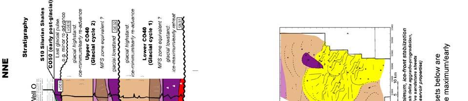
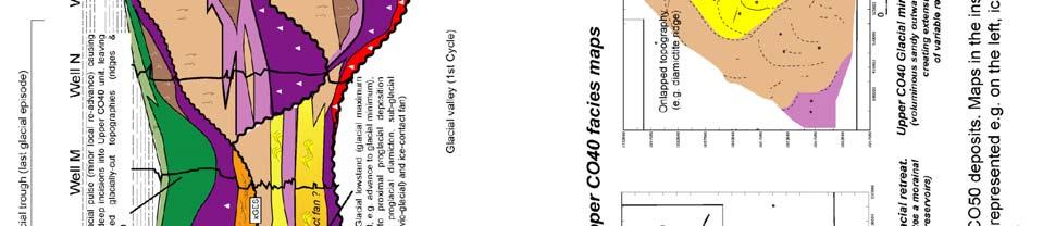
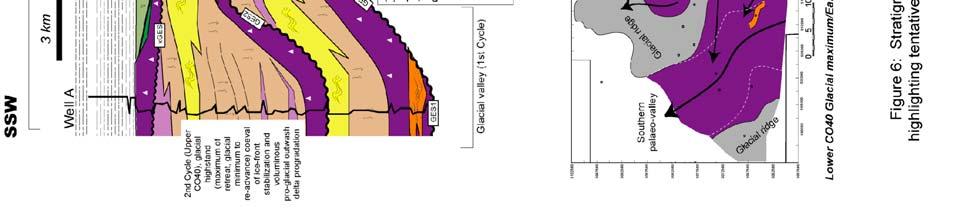
7 Early post-glacial transgressive interval (CO50 unit) CO40 glacigenic succession is capped by transgressive shallow marine shelf deposits belonging to the CO50 unit (Figure 6). Offshore marine dropstones-bearing mudstones (CO50.1) are draping glacigenic topographies and deposits. This mud-prone unit is rapidly followed by the deposition of progradational, bioturbated heterolithics sandstones and/or sharply overlain and/or replaced by clean coarse-grained cross-bedded sandstone (CO50.2). CO50 marine shelf to shoreline unit represents the transgressive remnants of the post-glacial Early Silurian flooding (comparative to above-described inter-glacial stage). CO50 facies succession is thought to be the record of the eustatic rise and isostatic rebound interplay towards the end of glaciation. The transgression peak was reached above, marked the deposition of the Silurian Hot Shales. Silurian shales (S10) Early Silurian high gamma Hot Shales, which sealed and sourced the gas horizons contained in the Cambrian and Upper Ordovician reservoirs, correspond to an abrupt deposition of anoxic, graptolite rich shales following early post-glacial CO50 shallow marine strata. The deposition of fines, blanketing the residual shallow marine topography suggests a rapid decrease of energy within the basin, certainly as the result of a global sea level rise triggered by the complete African polar ice cap melting. Syn-glacial and post-glacial stratigraphic architecture From facies analysis on cores and wireline electrofacies identification, syn-glacial (CO40) and postglacial (CO50) strata may be further subdivided respectively into Lower & Upper CO40 and CO50.1 & CO50.2. These divisions, which are thought to represent the 2 main glacial cycles recorded during the Late Ordovician Glaciation and the subsequent early post-glacial episode, have been defined, correlated, and mapped (Figure 6). CO40 glaciogenic strata are deposited within a complex palaeovalley-shaped topography mainly cut during the first and major glacial episode (Lower CO40). The Glacial Erosion Surface at the base of the Lower CO40 unit (GES-1) created multi parallel palaeovalley incisions (5 to 15 km wide, 60 to 120 m deep) deeply dug into pre-glacial units (Figure 6). Size and shape of such broad-scale incision may be attributed to tunnel valleys, and/or glacial troughs/ridges (mega-scale glacial lineations). During the subsequent early phase of retreat and/or during late glacial maximum phase, localized ice-contact fans associated to subglacial channels are developed at the base of the depressions. During glacial retreat and subsequent ice-front stabilization (e.g. Southwards of the studied area), outwash dominated sand-prone facies are partly filling remnants of topography. The Glacial Erosion Surface associated to Upper CO40 (GES-2) consists of a relative low relief erosion surface, that creates wide and shallow glacial ridges and troughs. Localized sub-glacial channel shapes (e.g. tunnel channel?) are evidenced. During the late phase of advance and/or early retreat thick sub-glacial to pro-glacial diamictite-prone units are developed testifying of stagnant icefront in the area. These mud-prone units form diamictite ridges inferred as subaqueous grounded-line morainal banks (Figure 6). Subsequent retreat of ice-front leads to the growth of a voluminous and correlative sandy outwash delta. The correlative thick (up to 60m thick) and widespread outwash delta sand body is regarded as a progradational (coarsening and cleaning upward) trending unit, deposited at the top of the first high frequency ice-advance cycle of Upper CO40. A last and minor inferred glacial re-advance may be recognized (xges, Figure 6) dissecting the above-mentioned proglacial outwash delta sand body. Subsequent flash retreat of ice-front left underfilled glacial topography, itself corrected and partly filled during early post-glacial times (CO50). CO50 unit records transgressive early post-glacial conditions. Influences of underfilled glacial topography and coeval isostatic rebound processes are the major control over its distribution (e.g. in terms of facies-type and thickness). Mud-prone deposition (CO50.1 unit) particularly overthickens in underfilled depressions (glacial troughs), whereas both isostatic process and local topographic influences (remnant palaeo-highs; glacial ridges), enhance erosion and reworking, that lead to shallow marine sand-prone shelf development (CO50.2 unit) in the more elevated areas (Figure 6).
8
9 Conclusions Applying allostratigraphic approach on Late Ordovician syn-glacial strata (CO40) of the the Tiguentourine Field (Illizi basin, Algeria) allowed the recognition and lateral correlations of glacial depositional sequences (GS) bounded by glacial erosion surfaces (GES). These sequences represent minor ice-sheet advance/retreat cycles, where deposition occurred exclusively during ice-sheet retreat and subsequent ice-front stabilization. Depositional environments are ranging from sub-glacial to proglacial and/or peri-glacial conditions. Stratigraphic correlations of the glacial depositional sequences allowed deciphering the sedimentary architecture (e.g. internal layering and sizes of sedimentary bodies) of syn- and post-glacial strata. Within the syn-glacial CO40 succession, two main glacial cycles are recognized and correlated across the Tiguentourine Field. Each cycle involves a complex stratigraphic architecture that reflects the complexity of glaciogenic depositional environments and superimposed minor higher-frequency ice advance/retreat. As a consequence, each cycle may be tentatively further subdivided into several iceadvance/retreat episodes (as obviously inferred for the Upper CO40 cycle). Immediately following the last glaciation, the CO50 post-glacial unit was deposited throughout the Tiguentourine field area. CO50 package includes transgressive shallow marine sediments deposited on a drowned glacially-cut topography ensuing isostatic rebound, suggesting definitive retreat of icesheet of the area, prior to the Silurian flooding. Established correlations indicate the development of heterogeneous reservoirs within glacial sequence ranging in two end-members: (1) discrete and highly variable sandy sub-glacial facies, (2) extensive and voluminous pro- to peri-glacial sandy outwash fan facies. The very locally developed transgressive sandstones, deposited during the post-glacial isostatic rebound, may be considered as an additional reservoir play.
Accommodation. Tectonics (local to regional) Subsidence Uplift
 Subsidence Uplift") Accommodation Accommodation varies over time; it is the distance between a reference horizon and the sea surface (i.e. relative sea level). The space to be filled in with sediments or water What are the
Accommodation Accommodation varies over time; it is the distance between a reference horizon and the sea surface (i.e. relative sea level). The space to be filled in with sediments or water What are the
Outcrops from Every Continent and 20 Countries in 140 Contributions. Tor H. Nilsen, Roger D. Shew, Gary S. Steffens, and Joseph R.J. Studlick.
 Paper VIII Tor H. Nilsen, Roger D. Shew, Gary S. Steffens, and Joseph R.J. Studlick Editors Outcrops from Every Continent and 20 Countries in 140 Contributions http://bookstore.aapg.org Length ~ 23 m (75.5
Bulletin of Earth Sciences of Thailand
 Depositional Environments and Stratigraphic Development of the Grand Taman Sari Circuit Outcrop: an Analogue for Transgressive Mahakam Delta Successions Ridha Santika Riadi Petroleum Geoscience Program,
Viking Lowstand Deposits in West Central Saskatchewan: Depositional Model for the Reservoir Units in Dodsland-Hoosier Area, Saskatchewan, Canada
 Viking Lowstand Deposits in West Central Saskatchewan: Depositional Model for the Reservoir Units in Dodsland-Hoosier Area, Saskatchewan, Canada Hasan Ferdous* PetroSed Geoconsulting Resources, Calgary,
Depositional Sequences Sequences
 Depositional Sequences Transgressive and Regressive packages can be bound by unconformities Because sediment can only be preserved during net aggradation and progradation All other times there is either
Sequence Stratigraphy. Historical Perspective
 Sequence Stratigraphy Historical Perspective Sequence Stratigraphy Sequence Stratigraphy is the subdivision of sedimentary basin fills into genetic packages bounded by unconformities and their correlative
Glauconitic Oil Reservoirs in Southern Alberta Creating the Correct Geological Model to Guide Development Drilling
 Glauconitic Oil Reservoirs in Southern Alberta Creating the Correct Geological Model to Guide Development Drilling Brad Hayes* Petrel Robertson Consulting Ltd, Calgary, AB bhayes@petrelrob.com Lisa Griffith
Meandering Miocene Deep Sea Channel Systems Offshore Congo, West Africa
 Meandering Miocene Deep Sea Channel Systems Offshore Congo, West Africa S. Baer* (PGS), J. E. Comstock (PGS), K. Vrålstad (PGS), R. Borsato (PGS), M. Martin (PGS), J.P. Saba (SNPC), B. Débi-Obambé (SNPC)
THE DEPOSITS OF TSUNAMIS WESLEY PESANTEZ, CATHERINE NIELD, COLIN WINTER
 THE DEPOSITS OF TSUNAMIS WESLEY PESANTEZ, CATHERINE NIELD, COLIN WINTER AN OVERVIEW OF OUR SEMINAR WHAT IS A TSUNAMI WHY STUDY TSUNAMIS PROPERTIES OF TSUNAMIS TSUNAMI HYDRODYNAMICS IDEALIZED DEPOSITS SEDIMENT
Search and Discovery Article #40536 (2010) Posted June 21, 2010
 Posted June 21, 2010") Modern Examples of Mass Transport Complexes, Debrite and Turbidite Associations: Geometry, Stratigraphic Relationships and Implications for Hydrocarbon Trap Development* Fabiano Gamberi 1, Marzia Rovere
Modern Examples of Mass Transport Complexes, Debrite and Turbidite Associations: Geometry, Stratigraphic Relationships and Implications for Hydrocarbon Trap Development* Fabiano Gamberi 1, Marzia Rovere
Facies Analysis Of The Reservoir Rocks In The. Sylhet Trough, Bangladesh. Abstract
 Facies Analysis Of The Reservoir Rocks In The Sylhet Trough, Bangladesh Joyanta Dutta Petroleum Geoscience Program, Department of Geology, Faculty of Science, Chulalongkorn University, Bangkok 10330, Thailand
Chapter 8: Learning objectives
 Chapter 8: Learning objectives Understand concept of sedimentary facies Signinifance of lateral and vertical facies associations Walther s Law Understand the sedimentary facies of alluvial fans, eolian
Basin Analysis Applied to Modelling Buried Valleys in the Great Lakes Basin
 EARTH SCIENCES SECTOR GENERAL INFORMATION PRODUCT 35 Basin Analysis Applied to Modelling Buried Valleys in the Great Lakes Basin Sharpe, D R; Russell, H A J 2004 Originally released as: Basin Analysis
Lab 7: Sedimentary Structures
 Name: Lab 7: Sedimentary Structures Sedimentary rocks account for a negligibly small fraction of Earth s mass, yet they are commonly encountered because the processes that form them are ubiquitous in the
EARTH SURFACE PROCESSES AND SEDIMENTATION!
 Sed and Strat EARTH SURFACE PROCESSES AND SEDIMENTATION! 2/27 Lecture 7- Exposure: Weathering and the Sediment Factory 3/04 Lecture 8 - Rivers and Landscapes 3/06 Lecture 9 - Waves (not Tides) 3/11 Lecture
Seismic Expressions of Submarine Channel - Levee Systems and Their Architectural Elements
 Seismic Expressions of Submarine Channel - Levee Systems and Their Architectural Elements Summary D.V. Ramana, Santanu De* and Kalyanbrata Datta KDMIPE, ONGC, Dehradun E-mail- devvenram@rediffmail.com
Buried-valley Aquifers: Delineation and Characterization from Reflection Seismic and Core Data at Caledon East, Ontario
 Buried-valley Aquifers: Delineation and Characterization from Reflection Seismic and Core Data at Caledon East, Ontario Russell, H.A.J. 1, S.E. Pullan 1, J.A. Hunter 1, D.R. Sharpe 1, and S. Holysh 2 1
Chapter 5. The Sedimentary Archives
 Chapter 5 The Sedimentary Archives Factors affecting Sedimentary Characteristics 1. Tectonic setting 2. Physical, chemical, and biological processes in the depositional environment 3. Method of sediment
4.1 Sediment accommodation space principles and controls
 58 The sedimentary record of sea-level change 4. Sediment accommodation space principles and controls Sequence stratigraphy emphasizes the importance of the space that is made available within a basin
Facies Cryptic description Depositional processes Depositional environments Very well sorted. Desert dunes. Migration of straight crested mega ripples
 Very well sorted Travelled grate distance, effective sorting 5 medium-grained sandstone with well rounded grains; large scale high angle planar cross-beds. Migration of straight crested mega ripples Desert
Moosehead Lake and the Tale of Two Rivers
 Maine Geologic Facts and Localities June, 2005 45 o 53 5.09 N, 69 o 42 14.54 W Text by Kelley, A.R.; Kelley, J.T.; Belknap, D.F.; and Gontz, A.M. Department of Earth Sciences, University of Maine, Orono,
Site 4.7. Thornhill Drumlin Jane K. Hart
 Site 4.7. Thornhill Drumlin Jane K. Hart Introduction The drumlins in the West of Ireland represent some of the best exposured features in the whole of Britain and Ireland, and have been studied by numerous
Introduction to sequence stratigraphy and its application to reservoir geology
 Introduction to sequence stratigraphy and its application to reservoir geology Massimo Zecchin Istituto Nazionale di Oceanografia e di Geofisica Sperimentale - OGS Historical development Definitions Systems
Controls on clastic systems in the Angoche basin, Mozambique: tectonics, contourites and petroleum systems
 P2-2-13 Controls on clastic systems in the Angoche basin, Mozambique: tectonics, contourites and petroleum systems Eva Hollebeek, Olivia Osicki, Duplo Kornpihl Schlumberger, London, UK Introduction Offshore
BALOCHISTAN FOLDBELT BASIN
 INTRODUCTION BALOCHISTAN FOLDBELT BASIN The Kharan-3 block is located in the Kharan Trough of Balochistan Basin. GEOLOGICAL SETTING The Balochistan Province is an Upper Cretaceous to Recent structurally
Sediment and sedimentary rocks Sediment
 Sediment and sedimentary rocks Sediment From sediments to sedimentary rocks (transportation, deposition, preservation and lithification) Types of sedimentary rocks (clastic, chemical and organic) Sedimentary
David Piper and Atika Karim ABSTRACT
 David Piper and Atika Karim ABSTRACT Hyperpycnal flow deposits, or delta-front turbidites, are becoming increasingly recognised as important components of some deltaic systems. The presence of Bouma Tabce
The 3-D Seismic Geomorphology of Deep-Water Slope Channel Systems A Case Study from the Deep Water Nile Delta
 Geological Society of Trinidad & Tobago The 3-D Seismic Geomorphology of Deep-Water Slope Channel Systems A Case Study from the Deep Water Nile Delta Nigel E. Cross Presentation Outline Introduction Deep
The Nature of Sedimentary Rocks
 The Nature of Sedimentary Rocks Sedimentary rocks are composed of: Fragments of other rocks Chemical precipitates Organic matter or biochemically produced materials The Nature of Sedimentary Rocks Sedimentary
Summary. Introduction. Observations and Interpretations
 Lower McMurray Formation sinkholes and their fill fabrics: effects of salt dissolution collapse-subsidence across the northern Athabasca oil sands deposit Paul L. Broughton, Chevron Canada Resources, Calgary,
Effects of Tides on Deltaic Deposition: Causes and Responses*
 Effects of Tides on Deltaic Deposition: Causes and Responses* Piret Plink-Bjorklund 1 Search and Discovery Article #50626 (2012)** Posted June 25, 2012 *Adapted from oral presentation at AAPG Annual Convention
ES120 Sedimentology/Stratigraphy
 Midterm Exam 5/05/08 NAME: 1. List or describe 3 physical processes that contribute to the weathering of rocks (3pts). exfoliation frost wedging many others. roots, thermal expansion/contraction also credit
Volcanic Mass Flow Processes and Deposits
 Volcanic Mass Flow Processes and Deposits Smith and Lowe, 1991 Lahars=hyperconcentrated (flood) flow (HFF) and debris flow Note ideal HFF deposit has normal grading, parallel bedding, better sorting Ideal
Data Repository item
 Data Repository (B25407): Localities and descriptions of measured sections of study areas Table 1. Localities of the measured sedimentary sections in the NW Sichuan Basin Section Number Stratigraphy Locality
Seismic interpretation. Principles of seismic stratigraphic interpretation
 Seismic interpretation Principles of seismic stratigraphic interpretation Seismic interpretation Seismic stratigraphy is a technical for interpreting stratigraphic information from seismic data. The resolution
DATA ANALYSIS AND INTERPRETATION
 III. DATA ANALYSIS AND INTERPRETATION 3.1. Rift Geometry Identification Based on recent analysis of modern and ancient rifts, many previous workers concluded that the basic structural unit of continental
Sediment. Weathering: mechanical and chemical decomposition and disintegration of rock and minerals at the surface
 Sediment Some basic terminology Weathering: mechanical and chemical decomposition and disintegration of rock and minerals at the surface Erosion: removal of weathered rock and minerals from one place to
Deep Water Systems and Sequence Stratigraphy. By: Matt Kyrias, Chris Majerczyk, Nick Whitcomb, Wesley Vermillion
 Deep Water Systems and Sequence Stratigraphy By: Matt Kyrias, Chris Majerczyk, Nick Whitcomb, Wesley Vermillion Contents Gravity Flow Depositional Elements Defined References NOTE: Source uses seismic
Reconstruction of the Vistula ice stream lobe during LGM: preliminary results of the research project
 Ice, water, humans Quaternary landscape evolution in the Peribaltic Region 35th Annual conference of the German Quaternary Association DEUQUA e.v. 12th Annual Conference of the INQUA PeriBaltic WG 13th-17th
LONG ISLAND CLAST ORIENTATIONS
 LONG ISLAND CLAST ORIENTATIONS AND WHAT THEY TILL US Elliot Klein and Dan Davis Department of Geosciences, State University of New York at Stony Brook, 11794 Long Island glacigenic surface deposits, where
Glaciers. (Shaping Earth s Surface, Part 6) Science 330 Summer 2005
 Science 330 Summer 2005") Glaciers (Shaping Earth s Surface, Part 6) Science 330 Summer 2005 1 Glaciers Glaciers are parts of two basic cycles Hydrologic cycle Rock cycle Glacier a thick mass of ice that originates on land from
Glaciers (Shaping Earth s Surface, Part 6) Science 330 Summer 2005 1 Glaciers Glaciers are parts of two basic cycles Hydrologic cycle Rock cycle Glacier a thick mass of ice that originates on land from
Fluid-Mud Deposits of the Lower Jurassic Tilje Formation, Offshore Mid-Norway By Aitor A. Ichaso and Robert W. Dalrymple 1
 Fluid-Mud Deposits of the Lower Jurassic Tilje Formation, Offshore Mid-Norway By Aitor A. Ichaso and Robert W. Dalrymple 1 Search and Discovery Article #50107 (2008) Posted August 10, 2008 *Adapted from
GeoCanada 2010 Working with the Earth
 Lithofacies Identification and the Implications for SAGD Well Planning in the McMurray Formation, Christina Lake Area, Alberta Travis Shackleton*, Robert Gardner, Sung Youn, Grace Eng and Lori Barth Cenovus
Infilled Kettle Hole, Easton, Aroostook County, Maine
 Maine Geologic Facts and Localities June, 1997, Maine 46 41 26.40 N, 67 48 35.74 W Text by Tom Weddle, Department of Agriculture, Conservation & Forestry 1 Introduction As the last continental glacier
1 : TOTAL E&P, Technology Centre, CSTJF, Pau France 2 : ENSEGID - Bordeaux INP 3 : TOTAL E&P Qatar
 Stratigraphy and sedimentology of the middle Cenomanian Natih Formation in the Jabal Shams area (Jabal Akhdar, Sultanate of Oman): An outcrop analogue for reservoir heterogeneity in the Mishrif Formation
Introduction. Methods
 Y034 The Glaciogenic Reservoir Analogue Studies Project (GRASP) - An Integrated Approach to Unravel Genesis, Infill and Architecture of Tunnel Valleys Reservoirs A. Moscariello* (University of Geneva),
High-resolution Sequence Stratigraphy of the Glauconitic Sandstone, Upper Mannville C Pool, Cessford Field: a Record of Evolving Accommodation
 Page No. 069-1 High-resolution Sequence Stratigraphy of the Glauconitic Sandstone, Upper Mannville C Pool, Cessford Field: a Record of Evolving Accommodation Thérèse Lynch* and John Hopkins, Department
Revised reservoir model for the Paleocene mounds of the Utsira High, North Sea, Norway John Wild (1) & Nowell Briedis (2)
 & Nowell Briedis (2)") Revised reservoir model for the Paleocene mounds of the Utsira High, North Sea, Norway John Wild (1) & Nowell Briedis (2) (1) Mobil North Sea LLC (2) Esso Exploration & Production Norway A/S (ExxonMobil
Revised reservoir model for the Paleocene mounds of the Utsira High, North Sea, Norway John Wild (1) & Nowell Briedis (2) (1) Mobil North Sea LLC (2) Esso Exploration & Production Norway A/S (ExxonMobil
TERRESTRIAL AND SHALLOW-MARINE DEPOSITS OF CENTRAL- CARPATHIAN PALEOGENE BASIN: EXAMPLE FROM EASTERN SLOVAKIA J. JANOČKO
 TERRESTRIAL AND SHALLOW-MARINE DEPOSITS OF CENTRAL- CARPATHIAN PALEOGENE BASIN: EXAMPLE FROM EASTERN SLOVAKIA J. JANOČKO Geological Survey of Slovak Republic, Jesenského 8, 040 11 Košice, Slovakia Abstract:
Sediment and Sedimentary rock
 Sediment and Sedimentary rock Sediment: An accumulation of loose mineral grains, such as boulders, pebbles, sand, silt or mud, which are not cemented together. Mechanical and chemical weathering produces
11/22/2010. Groundwater in Unconsolidated Deposits. Alluvial (fluvial) deposits. - consist of gravel, sand, silt and clay
 deposits. - consist of gravel, sand, silt and clay") Groundwater in Unconsolidated Deposits Alluvial (fluvial) deposits - consist of gravel, sand, silt and clay - laid down by physical processes in rivers and flood plains - major sources for water supplies
Groundwater in Unconsolidated Deposits Alluvial (fluvial) deposits - consist of gravel, sand, silt and clay - laid down by physical processes in rivers and flood plains - major sources for water supplies
GEL 109 Midterm W01, Page points total (1 point per minute is a good pace, but it is good to have time to recheck your answers!
 GEL 109 Midterm W01, Page 1 50 points total (1 point per minute is a good pace, but it is good to have time to recheck your answers!) 1. Where in a water flow is there usually a zone of laminar flow even
Geo 302D: Age of Dinosaurs. LAB 2: Sedimentary rocks and processes
 Geo 302D: Age of Dinosaurs LAB 2: Sedimentary rocks and processes Last week we covered the basic types of rocks and the rock cycle. This lab concentrates on sedimentary rocks. Sedimentary rocks have special
Chapter 2. Wearing Down Landforms: Rivers and Ice. Physical Weathering
 Chapter 2 Wearing Down Landforms: Rivers and Ice Physical Weathering Weathering vs. Erosion Weathering is the breakdown of rock and minerals. Erosion is a two fold process that starts with 1) breakdown
Chapter 5: Glaciers and Deserts
 I. Glaciers and Glaciation Chapter 5: Glaciers and Deserts A. A thick mass of ice that forms over land from the compaction and recrystallization of snow and shows evidence of past or present flow B. Types
OUTCROP! CHARACTERISATION! OF! TRANSGRESSIVE! SANDSTONE! RESERVOIRS:! QUANTITATIVE!COMPARISON!OF!OUTCROP!ANALOGUES!
 OUTCROP CHARACTERISATION OF TRANSGRESSIVE SANDSTONE RESERVOIRS: QUANTITATIVECOMPARISONOFOUTCROPANALOGUES OLIVER D. JORDAN 1, PETER J. SIXSMITH 2, GARY J. HAMPSON, SANJEEV GUPTA & HOWARDD.JOHNSON DepartmentofEarthScienceandEngineering,ImperialCollegeLondon,SouthKensington
Sequence Stratigraphy as a tool for water resources management in alluvial coastal aquifers: application to the Llobregat delta (Barcelona, Spain)
") Sequence Stratigraphy as a tool for water resources management in alluvial coastal aquifers: application to the Llobregat delta (Barcelona, Spain) Desiré Gàmez Torrent December 2007 CHAPTER 1: Introduction
Sequence Stratigraphy as a tool for water resources management in alluvial coastal aquifers: application to the Llobregat delta (Barcelona, Spain) Desiré Gàmez Torrent December 2007 CHAPTER 1: Introduction
Glaciers form wherever snow and ice can accumulate High latitudes High mountains at low latitudes Ice temperatures vary among glaciers Warm
 The Cryosphere Glaciers form wherever snow and ice can accumulate High latitudes High mountains at low latitudes Ice temperatures vary among glaciers Warm (temperate) glaciers: at pressure melting point,
mountain rivers fixed channel boundaries (bedrock banks and bed) high transport capacity low storage input output
 high transport capacity low storage input output") mountain rivers fixed channel boundaries (bedrock banks and bed) high transport capacity low storage input output strong interaction between streams & hillslopes Sediment Budgets for Mountain Rivers Little
mountain rivers fixed channel boundaries (bedrock banks and bed) high transport capacity low storage input output strong interaction between streams & hillslopes Sediment Budgets for Mountain Rivers Little
Glaciers Earth 9th Edition Chapter 18 Glaciers: summary in haiku form Key Concepts Glaciers Glaciers Glaciers Glaciers
 1 2 3 4 5 6 7 8 9 10 11 12 13 14 Earth 9 th Edition Chapter 18 : summary in haiku form Ten thousand years thence big glaciers began to melt - called "global warming." Key Concepts and types of glaciers.
Relationship between River-mouth Depositional Processes and Delta Architectures, Huangqihai Lake, Inner Mongolia, North China*
 Relationship between River-mouth Depositional Processes and Delta Architectures, Huangqihai Lake, Inner Mongolia, North China* Shunli Li 1,3, Xinghe Yu 2, Shengli Li 2, Cornel Olariu 3, and Ronald Steel
Foundations of Earth Science, 6e Lutgens, Tarbuck, & Tasa
 Foundations of Earth Science, 6e Lutgens, Tarbuck, & Tasa Glacial and Arid Landscapes Foundations, 6e - Chapter 4 Stan Hatfield Southwestern Illinois College Glaciers Glaciers are parts of two basic cycles
Geology and New England Landscapes
 Geology and New England Landscapes Jim Turenne, CPSS USDA-NRCS Warwick, RI. http://nesoil.com Why Geology? Provides the big picture of site conditions. Major part of soil formation (parent material and
Carboniferous Stratigraphic Analysis in the Subandean Foothills and the Chaco Plains of Tarija Basin-Bolivia.
 AAPG Convention, Denver 2001 Carboniferous Stratigraphic Analysis in the Subandean Foothills and the Chaco Plains of Tarija Basin-Bolivia. VIERA, ATILIO F., Pluspetrol E&P, Buenos Aires, Argentina; HERNANDEZ
Depositional History and Petroleum Potential of Ombilin Basin, West Sumatra - Indonesia, Based on Surface Geological Data*
 Depositional History and Petroleum Potential of Ombilin Basin, West Sumatra - Indonesia, Based on Surface Geological Data* Yahdi Zaim 1, Litto Habrianta 2, Chalid I. Abdullah 1, Aswan 1, Yan Rizal 1, Nurcahyo
SEQUENCE STRATIGRAPHY
 SEQUENCE STRATIGRAPHY Course of Stratigraphy G301 Second semester (February-June2014) Department of Geology College of Science/University of Basrah Instructor:Dr. Nawrast S. Abd Alwahab Lecture 4 & 5 1
Bulletin of Earth Sciences of Thailand
 Quantitative Seismic Geomorphology of Early Miocene to Pleistocene Fluvial System of Northern Songkhla Basin, Gulf of Thailand Oanh Thi Tran Petroleum Geoscience Program, Department of Geology, Faculty
LOWER GRAND RAPIDS BITUMEN POOLS AT COLD LAKE, ALBERTA VARIATIONS IN STRATIGRAPHIC SETTING AND DEPOSITIONAL ENVIRONMENTS
 RAPIDS BITUMEN POOLS AT COLD LAKE, ALBERTA VARIATIONS IN STRATIGRAPHIC SETTING AND DEPOSITIONAL ENVIRONMENTS Brad J. Hayes, Petrel Robertson Consulting Ltd. Garrett M. Quinn, OSUM Oil Sands Corp. Summary
The San Benito Gravels: Fluvial Depositional Systems, Paleocurrents, and Provenance
 ES120 FIELD TRIP #2 10 April 2010 NAME: The San Benito Gravels: Fluvial Depositional Systems, Paleocurrents, and Provenance Introduction The San Benito Gravels (SBG) consists of a 500 m thick section of
Lecture Outline Wednesday - Friday February 14-16, 2018
 Lecture Outline Wednesday - Friday February 14-16, 2018 Quiz 2 scheduled for Friday Feb 23 (Interlude B, Chapters 6,7) Questions? Chapter 6 Pages of the Past: Sedimentary Rocks Key Points for today Be
GEOL 440 Sedimentology and stratigraphy: processes, environments and deposits Lectures 16 & 17: Deltaic Facies
 GEOL 440 Sedimentology and stratigraphy: processes, environments and deposits Lectures 16 & 17: Deltaic Facies What controls morphology and facies of the Nile Delta? Basic processes Classification Facies
Seismic interpretation of carbonate turbidites in Central Luconia
 GeoL. Soc. MaLayaia, BuLLetin 47, December 2005; pp. 77-85 Seismic interpretation of carbonate turbidites in Central Luconia FRANcis Ho, GUENTER JAEGER AND PmT LAMBREGTS Sarawak Shell Berhad SMEP Exploration
Mammoth Cave National Park, Kentucky
 Mammoth Cave National Park, Kentucky Objectives of Today s Lecture Refresher on Sedimentary Depositional Systems and Rock Classifications Transgressive and Regressive Marine Environments Carbonate Depositional
PLATEAU UPLIFT, EPEIROGENEY AND CLIMATE CHANGES The KALAHARI PLATEAU, a world class laboratory
 PLATEAU UPLIFT, EPEIROGENEY AND CLIMATE CHANGES The KALAHARI PLATEAU, a world class laboratory F. Guillocheau M. De Wit G. Dubois B. Linol F. Eckardt W. Cotterill D. Rouby C. Robin Géosciences-Rennes Université
Lower Skinner Valley Fill Sandstones: Attractive Exploration Targets on the Northeast Oklahoma Platform*
 Lower Skinner Valley Fill Sandstones: Attractive Exploration Targets on the Northeast Oklahoma Platform* By Jim Puckette 1 Search and Discovery Article #10050 (2003) *Adapted from presentation to Tulsa
Sand. Sand is any eroded material (igneous, metamorphic or sedimentary) that has a grain size from 1/16 th to 2 millimeters in size.
 that has a grain size from 1/16 th to 2 millimeters in size.") Sedimentology 001 What is sedimentology? Sedimentology...encompasses the study of modern sediments such as sand [1], mud (silt) [2] andclay [3] and understanding the processes that deposit them.[4] It
Sedimentology 001 What is sedimentology? Sedimentology...encompasses the study of modern sediments such as sand [1], mud (silt) [2] andclay [3] and understanding the processes that deposit them.[4] It
Sequence Stratigraphy: An Applied Workshop
 Sequence Stratigraphy: An Applied Workshop Instructor: Prof. Octavian Catuneanu Level: Intermediate Duration: 5 days Course Description and Objectives This workshop presents the concepts and practical
Streams. Water. Hydrologic Cycle. Geol 104: Streams
 Streams Why study streams? Running water is the most important geologic agent in erosion, transportation and deposition of sediments. Water The unique physical and chemical properties of water make it
PECIKO GEOLOGICAL MODELING: POSSIBLE AND RELEVANT SCALES FOR MODELING A COMPLEX GIANT GAS FIELD IN A MUDSTONE DOMINATED DELTAIC ENVIRONMENT
 IATMI 2005-29 PROSIDING, Simposium Nasional Ikatan Ahli Teknik Perminyakan Indonesia (IATMI) 2005 Institut Teknologi Bandung (ITB), Bandung, 16-18 November 2005. PECIKO GEOLOGICAL MODELING: POSSIBLE AND
Page 1. Name:
 Name: 1) Which property would best distinguish sediment deposited by a river from sediment deposited by a glacier? thickness of sediment layers age of fossils found in the sediment mineral composition
The Building of the NYC Region
 The Building of the NYC Region Definitions Fall Line marks the area where an upland region (continental bedrock) and a coastal plain meet Piedmont the plateau region of the eastern United States which
Pratice Surface Processes Test
 1. The cross section below shows the movement of wind-driven sand particles that strike a partly exposed basalt cobble located at the surface of a windy desert. Which cross section best represents the
Application of Predictive Modeling to the Lower Cretaceous Sedimentary Sequences of the Central Scotian Basin
 Application of Predictive Modeling to the Lower Cretaceous Sedimentary Sequences of the Central Scotian Basin Christopher R. Sangster 1, Nicolas Hawie 2, Georgia Pe-Piper 1, Francky Saint-Ange 2, David
The Late Tertiary Deep-Water Siliciclastic System of the Levant Margin - An Emerging Play Offshore Israel*
 The Late Tertiary Deep-Water Siliciclastic System of the Levant Margin - An Emerging Play Offshore Israel* Michael A. Gardosh 1, Yehezkel Druckman 2 and Binyamin Buchbinder 2 Search and Discovery Article
Image: G. Parker. Presenters: Henry Chan, Kayla Ireland, Mara Morgenstern, Jessica Palmer, Megan Scott
 Image: G. Parker Presenters: Henry Chan, Kayla Ireland, Mara Morgenstern, Jessica Palmer, Megan Scott Is the Ross Formation a suitable analog for sand-rich turbidite plays in passive margin basins? Play:
The unknown giants - low-permeability shallow gas reservoirs of southern Alberta and Saskatchewan, Canada.
 The unknown giants - low-permeability shallow gas reservoirs of southern Alberta and Saskatchewan, Canada. Shaun O'Connell* Belfield Resources Inc., Calgary belfield@shaw.ca ABSTRACT The gas reserves contained
Depositional Environment
 Depositional Environment Sedimentary depositional environment describes the combination of physical, chemical and biological processes associated with the deposition of a particular type of sediment. Types
=%REPORT RECONNAISSANCE OF CHISHOLM LAKE PROSPECT. October 25, 1977
 =%REPORT ON FIELD RECONNAISSANCE OF CHISHOLM LAKE PROSPECT October 25, 1977 Bruce D. Vincent Imperial Oil Limited, Minerals - Coal, CALGARY, ALBERTA CHISHOLM LAKE PROSPECT Introduction The Chisholm Lake
Sedimentary Rocks. Origin, Properties and Identification. Geology Laboratory GEOL 101 Lab Ray Rector - Instructor
 Sedimentary Rocks Origin, Properties and Identification Geology Laboratory GEOL 101 Lab Ray Rector - Instructor Sedimentary Rock Origin and Identification Lab Pre-Lab Internet Link Resources 1) http://www.rockhounds.com/rockshop/rockkey/index.html
NDWRCDP Disclaimer This work was supported by the National Decentralized Water Resources Capacity Development Project (NDWRCDP) with funding provided
 with funding provided") Glacial Landforms NDWRCDP Disclaimer This work was supported by the National Decentralized Water Resources Capacity Development Project (NDWRCDP) with funding provided by the U.S. Environmental Protection
Glacial Landforms NDWRCDP Disclaimer This work was supported by the National Decentralized Water Resources Capacity Development Project (NDWRCDP) with funding provided by the U.S. Environmental Protection
Depositional Environments. Depositional Environments
 Depositional Environments Geographic area in which sediment is deposited Characterized by a combination of geological process & environmental conditions Depositional Environments Geological processes:
Sedimentary and Stratigraphic Analysis of the Viking Sand in the Edgerton/Wainwright Area, Central Alberta* By Russell Walz 1
 Sedimentary and Stratigraphic Analysis of the Viking Sand in the Edgerton/Wainwright Area, Central Alberta* By Russell Walz 1 Search and Discovery Article #50030 (2006) Posted June 25, 2006 *Extended abstract
SUPPLEMENTAL MATERIAL
 SUPPLEMENTAL MATERIAL DESCRIPTIONS OF OTHER STRATIGRAPHIC SECTIONS Cherry Creek In its middle reaches, Cherry Creek meanders between three paired terraces within a narrow bedrock valley. The highest is
Facies Analysis of the Lower Cretaceous Wilrich Member (Lower Falher) of the Spirit River Formation.
 of the Spirit River Formation.") Facies Analysis of the Lower Cretaceous Wilrich Member (Lower Falher) of the Spirit River Formation. Kerrie L. Bann, Ichnofacies Analysis Inc. and Daniel J. K. Ross, Tourmaline Oil Corp. Historically,
Facies Analysis of the Lower Cretaceous Wilrich Member (Lower Falher) of the Spirit River Formation. Kerrie L. Bann, Ichnofacies Analysis Inc. and Daniel J. K. Ross, Tourmaline Oil Corp. Historically,
Prentice Hall EARTH SCIENCE
 Prentice Hall EARTH SCIENCE Tarbuck Lutgens Chapter 7 Glaciers, Desert, and Wind 7.1 Glaciers Types of Glaciers A glacier is a thick ice mass that forms above the snowline over hundreds or thousands of
Applications of Borehole Imaging to Hydrocarbon Exploration and Production
 Applications of Borehole Imaging to Hydrocarbon Exploration and Production Instructor: Philippe MONTAGGION / NExT, Schlumberger Title: Petroleum Geology Consultant Specialty: Borehole Imaging, Petroleum
The Hydrologic Cycle
 CONTINENTAL DEPOSITIONAL ENVIRONMENTS fluvial desert lacustrine (lake) Glacial KEY PARAMETERS (VARIABLES) 1. Climate (Hydrologic Cycle) Annual Precip vs. Seasonality 2. Tectonics (Mountains) The Hydrologic
Lecture Outlines PowerPoint. Chapter 6 Earth Science 11e Tarbuck/Lutgens
 Lecture Outlines PowerPoint Chapter 6 Earth Science 11e Tarbuck/Lutgens 2006 Pearson Prentice Hall This work is protected by United States copyright laws and is provided solely for the use of instructors
The Coast: Beaches and Shoreline Processes
 1 2 3 4 5 6 7 8 9 The Coast: es and Shoreline Processes Trujillo & Thurman, Chapter 10 Oceanography 101 Chapter Objectives Recognize the various landforms characteristic of beaches and coastal regions.
PHYSICAL GEOGRAPHY. By Brett Lucas
 PHYSICAL GEOGRAPHY By Brett Lucas GLACIAL PROCESSES Glacial Processes The Impact of Glaciers on the Landscape Glaciations Past and Present Types of Glaciers Glacier Formation and Movement The Effects of