LOWER GRAND RAPIDS BITUMEN POOLS AT COLD LAKE, ALBERTA VARIATIONS IN STRATIGRAPHIC SETTING AND DEPOSITIONAL ENVIRONMENTS
|
|
|
- Dana Austin
- 5 years ago
- Views:
Transcription

1 RAPIDS BITUMEN POOLS AT COLD LAKE, ALBERTA VARIATIONS IN STRATIGRAPHIC SETTING AND DEPOSITIONAL ENVIRONMENTS Brad J. Hayes, Petrel Robertson Consulting Ltd. Garrett M. Quinn, OSUM Oil Sands Corp. Summary Mannville Group strata in the Cold Lake Oil Sands area host immense heavy oil and bitumen reserves, which are being produced using both cold and thermal recovery processes. Most thermal operations to date have focused on shallow marine and transitional sandstones of the Clearwater Formation. Substantial resources also exist in the Grand Rapids Formation, but our stratigraphic and reservoir knowledge of the Grand Rapids is not as advanced, and there are only two producing thermal operations. Our goal for this presentation is to characterize producing Grand Rapids reservoirs at Wolf Lake and Tucker Lake, and to compare stratigraphic boundaries and depositional settings with the Grand Rapids reservoir mapped by OSUM Oil Sands at Taiga (see adjacent Core Conference presentation by Quinn and Willmer). Regional Setting The Grand Rapids Formation lies above marine shales and lowstand shoreface sandstones of the Clearwater Formation, and beneath thick Joli Fou shales. Cant and Abrahamson (1997) interpreted Grand Rapids internal stratigraphy as: falling and lowstand sea level deposits which offlap from surfaces equivalent to updip unconformities. Six allostratigraphic units defined on the basis of regressive surfaces of erosion cut at the bases of shorefaces and transgressive surfaces at their tops have been defined. Each offlapping allostratigraphic unit consists in the south of thin channel and crevasse-splay sands grading northward into major shoreface sands. Maynard et al. (2010) demonstrated that a complex sequence stratigraphic architecture, building on the principles of the Cant and Abrahamson model, comprising nearshore marine facies punctuated by incised valley fills can be mapped in the Grand Rapids of the Cold Lake area. The current study area lies at the position of the arrow in Fig. 1, where the lower part of the Grand Rapids consists primarily of stacked deltaic to shoreface facies, while the upper part comprises marginal marine strata cut by flooding surfaces and estuarine valley fills at several levels. Reinforcing this placement, Beynon et al. (1988) established that Grand Rapids strata exhibit a well-developed brackish water ichnofauna in the Cold Lake area. Wolf Lake Lower Grand Rapids Pool Canadian Natural Resources Ltd. (CNRL) produces bitumen from a lower Grand Rapids sandstone body in Twp 65 and 66, Rge 5W4, using SAGD wells drilled from four pads. The primary lower Grand Rapids reservoir at Wolf Lake is a laterally-continuous sandier- and coarsening-upward succession interpreted as a delta strandplain to shoreface. The core from well W4 shows a well- GeoConvention 2014: FOCUS 1

2 NORTHWEST COLD LAKE / IRON RIVER AREA LINDBERG MARWANE SOUTH COLORADO GRP Joli Fou Fm W W W W W W W W W W W W W4 Sequences Sequence Sets Composite Sequence Colony Mclaren MANNVILLE GRP Grand Rapids Fm Waseca Sparky General Petroleums Rex Lloydminster Clearwater Fm DEPOSITIONAL ENVIRONMENT Fluvial valley fill Estuarine valley fill Coastal Plain Bay / lagoon Shoreface & backshore Offshore Figure 1. Schematic regional cross-section relating Mannville Group stratigraphy in east-central Alberta. Area indicates approximate position of Wolf Lake/Tucker Lake pools. 2
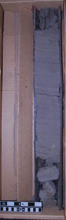
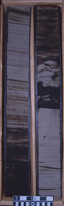
3 developed shoreface succession, grading up from heterolithic interbedded light grey muds and bitumen-stained sandstones, to massive bitumen-saturated sandstones in the upper several metres (Fig. 2). Bitumen saturation obscures sedimentary structures in clean sandstone sections, although large-scale low-angle planar lamination can be observed in places. Mudstone beds grade from mm scale where scarce, to cm and dm scale toward the base of the succession, where they can make up as much as 40-50% of the gross rock volume. While burrowing is neither diverse nor intense, there are isolated mud-filled burrows preserved within sandstone beds, and sand-filled burrows breaking mudstone beds. Grain size variation is limited, ranging generally from lower very fine to upper finegrained. The Wolf Lake shoreface is capped by a thin transgressive marine shale, correlative throughout the entire study area (and eastward through Tucker, to Taiga, as discussed below). There was no evidence noted of exposure, such as rooting or soils, at the top of the shoreface succession and beneath the transgressive shale marker. However, the shale marker has been eroded beneath younger channel deposits in some wells, particularly along the southeastern margin of the pool. Stratigraphic well log cross-sections demonstrate the continuity of the Wolf Lake shoreface through the study area, and in particular the continuity of the capping marine shale marker (Fig. 3). Two to three sandier-upward successions, interpreted as older lower Grand Rapids shorefaces, are seen to be regionally correlative between the Wolf Lake shoreface and the regional Clearwater Shale. Above the Wolf Lake shoreface, at least four regional flooding intervals are recognized and correlated within the upper Grand Rapids. The Wolf Lake shoreface is bounded along its southeastern margin by a younger incision event, while to the northwest it grades to more distal shoreface deposits with significant interbedded mudstones that degrade reservoir quality (Fig. 3). Net pay thickness in the developed area generally ranges from 12 to 15 metres, and the pay section features average porosity of 33% and average oil saturation of 75%, according to the operator. Reservoir sandstones are fine-grained sublitharenites that can be characterized fairly clearly on logs. Some uncertainty in net pay determination occurs in more distal facies with mudstone laminae, and additional bitumen volumes could be attributed to the pool by adopting less conservative net pay cutoffs. Tucker Lake Lower Grand Rapids Pool Husky Energy produces bitumen from a lower Grand Rapids sandstone in Twp 64, Rge 4W4, using a single SAGD pilot well pair, although additional drilling activity took place in The reservoir is interpreted to occur within an estuarine valley-fill complex. Cores from well 00/ W4 show a thick, homogeneous bitumen-saturated sandstone, fining upward from upper fine to lower medium at the base of the cored section to lower to upper fine-grained at the top. The entire cored section is within the valley fill, so there are no contact relationships to be examined. Bitumen saturations obscure sedimentary structures and other features, but pervasive low-angle large-scale cross-lamination can be seen toward the base of the core, as well as a couple of thin mud layers (clasts?) where saturations are lower. At 00/ W4, we see a section dominated by finely-laminated sandy mudstones and muddy sandstones, broken by the abrupt introduction of bitumen-saturated sandstones at the base of Core #2; unfortunately the contact appears to have been lost at the core break (Fig. 4). Large angular mud clasts dominate the basal 1.5 m of the sandstone succession, above which laminated cm- to dm-scale mudstone beds are common, with the uppermost substantial bitumen-saturated sandstone occurring above 6.5 m below the top of Core #1. The section is dominated by physical structures, with little burrowing. Low-angle large-scale lamination is most common, but finely-interbedded intervals show current ripples and climbing ripples highlighted by thin bitumen-stained sandstones. Small-scale softsediment faulting is evident in places. A stratigraphic cross-section (Fig. 5) shows to be within GeoConvention 2014: FOCUS 3
 Base")
 Base Top")


 (")


4 Top Top Core #6 (413m) Base Core #5 (412.9m) Base Top Core #4 (398m) Top Core #5 (407m) Base Core #4 (406.55m) Distal Shoreface Regional Wolf Lake Shoreface (Not Reservoir Facies, Lower Oil Saturation) (Reservoir Facies) Marine Shale Marker Figure 2. Core photos, Wolf Lake shoreface section, BP PCI 00/ W4. 4
5 <=1233.6m=> <=1587.4m=> <=1527.4m=> 100/ W4/00 Cdn Nat Rsrcs Lmtd W 1985/03/15 100/ W4/00 100/ W4/00 Cdn Nat Rsrcs Lmtd Cdn Nat Rsrcs Lmtd <=972.2m=> 1988/09/ /03/04 TIE W1-E1 100/ W4/00 Cdn Nat Rsrcs Lmtd /03/11 1AA/ W4/00 Cdn Nat Rsrcs Lmtd /03/07 OV W' Grand Rapids RAPIDS B 10 MARINE SHALE MARKER RAPIDS B 10 RAPIDS TUCKER VALLEY SHALE SHALE Figure 3. Stratigraphic cross-section W-W, Wolf Lake pool. 5
")


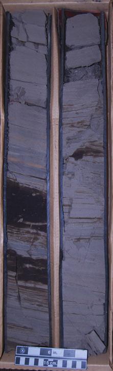


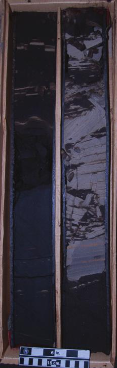

6 Top Top Core #3 (406m) Husky EOR C11 Cold Lake 00/13C W4 Top Core #2 (397m) Top Core #1 (388m) d Hayes Base Base Core #2 (405.9m) Base Core #1 (396.15m) Intra-Valley Scour Marked by Sandstone and Mud Clasts Near Top Valley Fill? Tucker Valley Fill (Non-Reservoir Facies) Figure 4. Core photos, Tucker Lake valley fill section, Husky 00/13C W4. 6
7 Grand Rapids MARINE SHALE MARKER RAPIDS B 10 SHALE 100/ W4/00 Husky Oil Oprtns Ltd T EX <=1090.8m=> 100/ W4/00 100/ W4/00 100/ W4/00 Husky Oil Oprtns Ltd Husky Oil Oprtns Ltd Husky Oil Oprtns Ltd <=610.1m=> <=825.1m=> 2001/03/19 T' NPW TIE W2-E2 Figure 5. Stratigraphic cross-section T-T, Tucker Lake pool. 7 RAPIDS TUCKER VALLEY MUDDY FILL SHALE
8 the Tucker Valley fill unit, and so we interpret this section as a mud-dominated valley fill, interrupted by a high-energy event depositing sandstone in an overall muddier-upward succession. Reservoir sandstones at Tucker are fine-grained litharenites containing substantial proportions of feldspars. While clean reservoir sandstones can be characterized reasonably well on logs, it is more difficult to distinguish facies with abundant mud laminae or clasts, partly because of hot gamma log signatures in the feldspathic sands. There is also relatively little contrast in resistivity values, making net pay determinations and picking of oil/water contacts difficult. Bottom water is thick and continuous along thick sand fairways in the south and east. Where the valley incision is thin or absent, we see a similar regional succession as at Wolf Lake a continuous Wolf Lake shoreface sandstone capped by a transgressive shale marker, overlain by a channelized unit. While the Wolf Lake shoreface is generally wet, the overlying unit shows good bitumen saturations in many places, and may represent an additional bitumen resource. Correlation to Taiga Area Regional cross-section A-A (Fig. 6) illustrates stratigraphic correlations from the CNRL Wolf Lake lower Grand Rapids pool in the west, eastward through the Husky Tucker Lake lower Grand Rapids pool, ending in the east at OSUM s Taiga project area in Twp 65, Rge 2W4, which is highlighted in the Core Conference display by Quinn and Willmer. The Grand Rapids is readily picked between the top Mannville and Clearwater shale markers. Several intervals can be picked more or less continuously within the Grand Rapids, including the Wolf Lake/B10 shoreface and its capping transgressive shale. OSUM s well AA/ W4 shows a bitumen-saturated Wolf Lake shoreface succession virtually identical to that observed at Wolf Lake. At 13-26, however, we see coaly clasts and a 12 cm coal bed in place at the top of the succession, suggesting preservation of capping shoreline/washover facies beneath the sharp transgressive surface at the base of the overlying marine shale marker. This shoreface sand is the primary reservoir unit in the lower Grand Rapids at Taiga. The stratigraphy in the Taiga area also includes incisions from the same marker as at Tucker, and from higher in the section (e.g., wells 1AX/ W4 and 1AA/ W4, Fig. 6). All these valleys contain sandy facies; however, the Tucker-age valley is entirely water-saturated. Relatively clean gamma log values and high resistivities at suggest a smaller lithic-feldspathic component than in the valley at Tucker Lake. References Beynon, B.M., S.G. Pemberton, D.D. Bell, and C.A. Logan, Environmental implications of ichnofossils from the Lower Cretaceous Grand Rapids Formation, Cold Lake Oil Sands deposit. In: Sequences, Stratigraphy, Sedimentology: Surface and Subsurface, CSPG Memoir 15, edited by D.P. James and D.A. Leckie, p Cant, D.J. and B. Abrahamson, Regional stratigraphy, sedimentology and petroleum geology of the Grand Rapids Formation, Mannville Group, northeastern Alberta. Bulletin of Canadian Petroleum Geology, v. 45, #2, p Maynard, J.R., H.R. Feldman, and R. Alway, From bars to valleys: the sedimentology and seismic geomorphology of fluvial to estuarine incised-valley fills of the Grand Rapids Formation (Lower Cretaceous), Iron River Field, Alberta, Canada. Journal of Sedimentary Research, v. 80, p GeoConvention 2014: FOCUS 8
9 A 100/ W4/00 1AA/ W4/00 100/ W4/00 1AX/ W4/00 1AA/ W4/00 1AA/ W4/00 <= m=> <=2590.1m=> <=8933.2m=> <= m=> <=6805.9m=> WEST EAST A' TUCKER W2-E2 TUCKER W2-E2 OSUM CORE PHOTOS WOLF LAKE W1-E1 TUCKER VALLEY FILL YOUNGER VALLEY G r a n d R a pids WOLF LAKE SHOREFACE WOLF LAKE SHOREFACE SHALE SHALE W o l f Lak e T uck e r Taiga Figure 6. Regional stratigraphic cross-section A-A, linking Grand Rapids oil accumulations at Wolf Lake, Tucker Lake, and Taiga. 9
Glauconitic Oil Reservoirs in Southern Alberta Creating the Correct Geological Model to Guide Development Drilling
 Glauconitic Oil Reservoirs in Southern Alberta Creating the Correct Geological Model to Guide Development Drilling Brad Hayes* Petrel Robertson Consulting Ltd, Calgary, AB bhayes@petrelrob.com Lisa Griffith
GeoCanada 2010 Working with the Earth
 Lithofacies Identification and the Implications for SAGD Well Planning in the McMurray Formation, Christina Lake Area, Alberta Travis Shackleton*, Robert Gardner, Sung Youn, Grace Eng and Lori Barth Cenovus
Modeling Lateral Accretion in McMurray Formation Fluvial- Estuarine Channel Systems: Grizzly Oil Sands May River SAGD Project, Athabasca
 Modeling Lateral Accretion in McMurray Formation Fluvial- Estuarine Channel Systems: Grizzly Oil Sands May River SAGD Project, Athabasca Duncan Findlay, Thomas Nardin, Alex Wright, Raheleh Salehi Mojarad
Sedimentary and Stratigraphic Analysis of the Viking Sand in the Edgerton/Wainwright Area, Central Alberta* By Russell Walz 1
 Sedimentary and Stratigraphic Analysis of the Viking Sand in the Edgerton/Wainwright Area, Central Alberta* By Russell Walz 1 Search and Discovery Article #50030 (2006) Posted June 25, 2006 *Extended abstract
Modeling Lateral Accretion in McMurray Formation Fluvial-Estuarine Channel Systems: Grizzly Oil Sands May River SAGD Project, Athabasca*
 Modeling Lateral Accretion in McMurray Formation Fluvial-Estuarine Channel Systems: Grizzly Oil Sands May River SAGD Project, Athabasca* Duncan Findlay 1, Thomas Nardin 1, Alex Wright 1, and Raheleh Salehi
High-resolution Sequence Stratigraphy of the Glauconitic Sandstone, Upper Mannville C Pool, Cessford Field: a Record of Evolving Accommodation
 Page No. 069-1 High-resolution Sequence Stratigraphy of the Glauconitic Sandstone, Upper Mannville C Pool, Cessford Field: a Record of Evolving Accommodation Thérèse Lynch* and John Hopkins, Department
6. Cretaceous Zone Play Results
 C H A P T E R S I X 6. Cretaceous Zone Play Results 6. Geological Overview The Mannville Group was deposited as a clastic wedge east of the mountain ranges. This wedge varies in thickness from 7 metres
Grand Rapids Oil Sands 3D Seismic Incorporating and Comparing Multiple Data Types for Reservoir Characterization
 Grand Rapids Oil Sands 3D Seismic Incorporating and Comparing Multiple Data Types for Reservoir Characterization Laurie M. Weston Bellman* Oil Sands Imaging Inc., Calgary, Alberta laurie@oilsandsimaging.com
Bulletin of Earth Sciences of Thailand
 Depositional Environments and Stratigraphic Development of the Grand Taman Sari Circuit Outcrop: an Analogue for Transgressive Mahakam Delta Successions Ridha Santika Riadi Petroleum Geoscience Program,
3rd-order sequence stratigraphy and lithostratigraphy of the Bearpaw Horseshoe Canyon transition, Alberta plains
 3rd-order sequence stratigraphy and lithostratigraphy of the Bearpaw Horseshoe Canyon transition, Alberta plains Ben Hathway, Alberta Geological Survey, Alberta Energy Regulator, Edmonton, Alberta, ben.hathway@aer.ca
Lower Skinner Valley Fill Sandstones: Attractive Exploration Targets on the Northeast Oklahoma Platform*
 Lower Skinner Valley Fill Sandstones: Attractive Exploration Targets on the Northeast Oklahoma Platform* By Jim Puckette 1 Search and Discovery Article #10050 (2003) *Adapted from presentation to Tulsa
Viking Lowstand Deposits in West Central Saskatchewan: Depositional Model for the Reservoir Units in Dodsland-Hoosier Area, Saskatchewan, Canada
 Viking Lowstand Deposits in West Central Saskatchewan: Depositional Model for the Reservoir Units in Dodsland-Hoosier Area, Saskatchewan, Canada Hasan Ferdous* PetroSed Geoconsulting Resources, Calgary,
Hydrocarbon Distribution in the Mannville Waseca Member, Edam Oil Field, West-central Saskatchewan
 Hydrocarbon Distribution in the Mannville Waseca Member, Edam Oil Field, West-central Saskatchewan Peter Hill 1 Information from this publication may be used if credit is given. It is recommended that
Facies Analysis of the Lower Cretaceous Wilrich Member (Lower Falher) of the Spirit River Formation.
 of the Spirit River Formation.") Facies Analysis of the Lower Cretaceous Wilrich Member (Lower Falher) of the Spirit River Formation. Kerrie L. Bann, Ichnofacies Analysis Inc. and Daniel J. K. Ross, Tourmaline Oil Corp. Historically,
Facies Analysis of the Lower Cretaceous Wilrich Member (Lower Falher) of the Spirit River Formation. Kerrie L. Bann, Ichnofacies Analysis Inc. and Daniel J. K. Ross, Tourmaline Oil Corp. Historically,
AAPG Search and Discovery Article #90173 CSPG/CSEG/CWLS GeoConvention 2011, Calgary, Alberta, Canada, May 9-11, 2011
 Use of Image Logs in Differentiating Point Bar and Tidal Bar Deposits in the Leismer Area: Implications for SAGD Reservoir Definition in the Athabasca Oilsands Howard Brekke and Andrew Couch Introduction
Anatomy of a Fluvial to Estuarine Valley Fill, North Cactus Lake McLaren Reservoir
 Anatomy of a Fluvial to Estuarine Valley Fill, North Cactus Lake McLaren Reservoir J. Edward Mathison Alethia Geologica, Filling of the north Cactus Lake post Waseca paleovalley, during McLaren sea level
Modeling Lateral Accretion in the McMurray Formation at Grizzly Oil Sands Algar Lake SAGD Project
 Modeling Lateral Accretion in the McMurray Formation at Algar Lake SAGD Project Duncan Findlay 1, Thomas Nardin 1, Andrew Couch 2, Alex Wright 1 1 ULC, 2 EON Introduction Laterally accreting channel systems
The unknown giants - low-permeability shallow gas reservoirs of southern Alberta and Saskatchewan, Canada.
 The unknown giants - low-permeability shallow gas reservoirs of southern Alberta and Saskatchewan, Canada. Shaun O'Connell* Belfield Resources Inc., Calgary belfield@shaw.ca ABSTRACT The gas reserves contained
The Clearwater Formation: A Facies Study for SAGD Water Source in the Athabasca Oil Sands
 The Clearwater Formation: A Facies Study for SAGD Water Source in the Athabasca Oil Sands Wallace, J. and Lavigne, J Introduction Water source has become an increasingly important issue recently with the
Geologic Considerations of Shallow SAGD Caprock; Seal Capacity, Seal Geometry and Seal Integrity, Athabasca Oilsands, Alberta Canada
 Geologic Considerations of Shallow SAGD Caprock; Seal Capacity, Seal Geometry and Seal Integrity, Athabasca Oilsands, Alberta Canada Gordon T. Stabb, Michael Webb Durando Resources Corp, Suncor Energy
Data Repository item
 Data Repository (B25407): Localities and descriptions of measured sections of study areas Table 1. Localities of the measured sedimentary sections in the NW Sichuan Basin Section Number Stratigraphy Locality
Accommodation. Tectonics (local to regional) Subsidence Uplift
 Subsidence Uplift") Accommodation Accommodation varies over time; it is the distance between a reference horizon and the sea surface (i.e. relative sea level). The space to be filled in with sediments or water What are the
Accommodation Accommodation varies over time; it is the distance between a reference horizon and the sea surface (i.e. relative sea level). The space to be filled in with sediments or water What are the
Facies Analysis Of The Reservoir Rocks In The. Sylhet Trough, Bangladesh. Abstract
 Facies Analysis Of The Reservoir Rocks In The Sylhet Trough, Bangladesh Joyanta Dutta Petroleum Geoscience Program, Department of Geology, Faculty of Science, Chulalongkorn University, Bangkok 10330, Thailand
The Impact of Parasequence Stacking Patterns on Vertical Connectivity Between Wave-Dominated, Shallow Marine Parasequences, Book Cliffs, Eastern Utah
 The Impact of Parasequence Stacking Patterns on Vertical Connectivity Between Wave-Dominated, Shallow Marine Parasequences, Book Cliffs, Eastern Utah MALCOLM J. ARNOT and TIMOTHY R. GOOD* MALCOLM J. ARNOT
EARTH SURFACE PROCESSES AND SEDIMENTATION!
 Sed and Strat EARTH SURFACE PROCESSES AND SEDIMENTATION! 2/27 Lecture 7- Exposure: Weathering and the Sediment Factory 3/04 Lecture 8 - Rivers and Landscapes 3/06 Lecture 9 - Waves (not Tides) 3/11 Lecture
OUTCROP! CHARACTERISATION! OF! TRANSGRESSIVE! SANDSTONE! RESERVOIRS:! QUANTITATIVE!COMPARISON!OF!OUTCROP!ANALOGUES!
 OUTCROP CHARACTERISATION OF TRANSGRESSIVE SANDSTONE RESERVOIRS: QUANTITATIVECOMPARISONOFOUTCROPANALOGUES OLIVER D. JORDAN 1, PETER J. SIXSMITH 2, GARY J. HAMPSON, SANJEEV GUPTA & HOWARDD.JOHNSON DepartmentofEarthScienceandEngineering,ImperialCollegeLondon,SouthKensington
DATA REPOSITORY MATERIAL: PALEOCHANNEL GROUP MAPPING DESCRIPTIONS
 Data Repository item 2695 DATA REPOSITORY MATERIAL: PALEOCHANNEL GROUP MAPPING DESCRIPTIONS Groups 1 (North Myrtle Beach) and 2 (Atlantic Beach) Channel Groups 1 (North Myrtle Beach) and 2 (Atlantic Beach)
Seismic stratigraphy, some examples from Indian Ocean, interpretation of reflection data in interactive mode
 Seismic stratigraphy, some examples from Indian Ocean, interpretation of reflection data in interactive mode K. S. Krishna National Institute of Oceanography, Dona Paula, Goa-403 004. krishna@nio.org Seismic
A Review of McMurray Formation Geology in Athabasca Oil Sands
 A Review of McMurray Formation Geology in Athabasca Oil Sands Rahman M. Hassanpour The Northern Alberta oil sands, containing the Athabasca, Peace River and Cold Lakes areas, are the largest oil sands
Lab 8: Facies Analysis and Correlations: Sequence Stratigraphy in the Book Cliffs, Utah
 Geology 109L Lab 8: Facies Analysis and Correlations: Sequence Stratigraphy in the Book Cliffs, Utah Goal: In this lab, you will put together your knowledge of near-shore facies and sequence stratigraphy
Bulletin of Earth Sciences of Thailand. Controls on Reservoir Geometry and Distribution, Tantawan Field, Gulf of Thailand.
 Controls on Reservoir Geometry and Distribution, Tantawan Field, Gulf of Thailand Atchara Praidee Petroleum Geoscience Program, Department of Geology, Faculty of Science, Chulalongkorn University, Bangkok
Conventional oil petroleum system of the Cenomanian - Turonian Blackstone Formation, Ferrier - Willesden Green - Gilby area, west-central Alberta
 Conventional oil petroleum system of the Cenomanian - Turonian Blackstone Formation, Ferrier - Willesden Green - Gilby area, west-central Alberta Kevin Greff, Department of Earth Sciences, Western University,
Characterization of Belloy, Kiskatinaw, and Debolt Water Disposal Zones in the Montney Play Area, NEBC
 Characterization of Belloy, Kiskatinaw, and Debolt Water Disposal Zones in the Montney Play Area, NEBC Brad J. Hayes Petrel Robertson Consulting Ltd. www.petrelrob.com Introduction Intensive development
Summary. Introduction. Observations and Interpretations
 Lower McMurray Formation sinkholes and their fill fabrics: effects of salt dissolution collapse-subsidence across the northern Athabasca oil sands deposit Paul L. Broughton, Chevron Canada Resources, Calgary,
Summary. Introduction
 Orthogonal geometrics of lower McMurray Formation sand complexes: effects of salt dissolution collapse-subsidence across the northern Athabasca oil sands deposit Paul L. Broughton, Chevron Canada Resources,
Dakota Sandstone. of the Moxa Arch and Surrounding Green River Basin
 Dakota Sandstone of the Moxa Arch and Surrounding Green River Basin Dakota Sandstones of the Green River Basin Overview The Dakota sandstones of the Moxa Arch and surrounding Green River Basin remain attractive
Case Study of the Structural and Depositional-Evolution Interpretation from Seismic Data*
 Case Study of the Structural and Depositional-Evolution Interpretation from Seismic Data* Yun Ling 1, Xiangyu Guo 1, Jixiang Lin 1, and Desheng Sun 1 Search and Discovery Article #20143 (2012) Posted April
Aptian/Albian Reservoir Development in the Jeanne d Arc Basin, Offshore Eastern Canada
 Aptian/Albian Reservoir Development in the Jeanne d Arc Basin, Offshore Eastern Canada Jonathan Marshall, Statoil Canada Ltd. Calgary, Alberta, Canada. jomars@statoil.com Introduction: The Jeanne d Arc
Depositional Sequences Sequences
 Depositional Sequences Transgressive and Regressive packages can be bound by unconformities Because sediment can only be preserved during net aggradation and progradation All other times there is either
Sedimentary System Characteristics of Deng-3 Section on Paleo-central. Uplift Belt in Northern Songliao Basin. Siyang Li1,a*
 Sedimentary System Characteristics of Deng-3 Section on Paleo-central Uplift Belt in Northern Songliao Basin Siyang Li1,a* 1 School of Earth Sciences and Resources, China University of Geosciences, Beijing,
Lotsberg Salt Formation Solution-mined Cavern for SAGD Solid Waste disposal, Cold Lake, Alberta.
 Lotsberg Salt Formation Solution-mined Cavern for SAGD Solid Waste disposal, Cold Lake, Alberta. Mark Rabin*, Osum Oil Sands, mrabin@osumcorp.com and Piotr Kukialka, Kukialka Consulting Ltd. piotr_kukialka@hotmail.com
Appraising a late-middle-aged Brent Group field
 Appraising a late-middle-aged Brent Group field Reservoir learnings after nearly 20 years of Pelican field production Jill Marriott The Pelican Field The Pelican oil field is nearly 20 years old It is
Sequence Stratigraphic Framework and Reservoir Architecture of the Lingshui-3 Member, Yacheng 13-1 Gas Field, South China Sea
 Sequence Stratigraphic Framework and Reservoir Architecture of the Lingshui-3 Member, Yacheng 13-1 Gas Field, South China Sea David Z. Tang BP China Exploration and Production Company 17/F, Finance Centre,
Revised reservoir model for the Paleocene mounds of the Utsira High, North Sea, Norway John Wild (1) & Nowell Briedis (2)
 & Nowell Briedis (2)") Revised reservoir model for the Paleocene mounds of the Utsira High, North Sea, Norway John Wild (1) & Nowell Briedis (2) (1) Mobil North Sea LLC (2) Esso Exploration & Production Norway A/S (ExxonMobil
Revised reservoir model for the Paleocene mounds of the Utsira High, North Sea, Norway John Wild (1) & Nowell Briedis (2) (1) Mobil North Sea LLC (2) Esso Exploration & Production Norway A/S (ExxonMobil
Carboniferous Stoddart Group: An integrated approach
 Carboniferous Stoddart Group: An integrated approach Abu Yousuf*, Department of Geoscience, University of Calgary, Calgary, Alberta yousufabu@hotmail.com and Charles M. Henderson, Department of Geoscience,
NAME: GEL 109 Final Winter 2010
 GEL 109 Final Winter 2010 1. The following stratigraphic sections represents a single event followed by the slow accumulation of background sedimentation of shale. Describe the flows that produced the
Nathan D. Webb and James L. Best
 Nathan D. Webb and James L. Best Background Pennsylvanian oil production Stratigraphy & geologic setting Study area Methods Using geophysical logs & core Results Comparing three channel deposits Implications
Search and Discovery Article #80372 (2014) Posted May 12, 2014
 Posted May 12, 2014") Paleozoic Stratigraphic Framework beneath the Muskeg River Mine, Northeastern Alberta (Twp 95, Rge 9-10W4): Controls and Constraints on Present Day Hydrogeology* R. Mahood 1, M. Verhoef 1, and F.A. Stoakes
Paleozoic Stratigraphic Framework beneath the Muskeg River Mine, Northeastern Alberta (Twp 95, Rge 9-10W4): Controls and Constraints on Present Day Hydrogeology* R. Mahood 1, M. Verhoef 1, and F.A. Stoakes
Geology of the Gull Lake North ASP Flood, Upper Shaunavon Formation, Southwest Saskatchewan
 Geology of the Gull Lake North ASP Flood, Upper Shaunavon Formation, Southwest Saskatchewan By Sid Leggett, Husky Energy (sid.leggett@huskyenergy.com) Acknowledgements Husky Energy Members of the Gull
 Tutors: Huw Williams & Paul Davies (Reservoir Geology Consultants Limited) Duration: A six day field and classroom-based reservoir geology and modelling course in Grand Junction, Colorado and Green River,
Delineating a sandstone reservoir at Pikes Peak, Saskatchewan using 3C seismic data and well logs
 Delineating a sandston reservoir at Pikes Peak Delineating a sandstone reservoir at Pikes Peak, Saskatchewan using 3C seismic data and well logs Natalia L. Soubotcheva and Robert R. Stewart ABSTRACT To
The 3-D Seismic Geomorphology of Deep-Water Slope Channel Systems A Case Study from the Deep Water Nile Delta
 Geological Society of Trinidad & Tobago The 3-D Seismic Geomorphology of Deep-Water Slope Channel Systems A Case Study from the Deep Water Nile Delta Nigel E. Cross Presentation Outline Introduction Deep
Introduction to sequence stratigraphy and its application to reservoir geology
 Introduction to sequence stratigraphy and its application to reservoir geology Massimo Zecchin Istituto Nazionale di Oceanografia e di Geofisica Sperimentale - OGS Historical development Definitions Systems
Subsurface Aquifer Study to Support Unconventional Oil and Gas Development, Liard Basin, Northeastern British Columbia (NTS 094J, K, N, O)
") Subsurface Aquifer Study to Support Unconventional Oil and Gas Development, Liard Basin, Northeastern British Columbia (NTS 094J, K, N, O) B.J.R. Hayes, Petrel Robertson Consulting Ltd., Calgary, AB, bhayes@petrelrob.com
Subsurface Aquifer Study to Support Unconventional Oil and Gas Development, Liard Basin, Northeastern British Columbia (NTS 094J, K, N, O) B.J.R. Hayes, Petrel Robertson Consulting Ltd., Calgary, AB, bhayes@petrelrob.com
Petrophysical Analysis and Sequence Stratigraphy Appraisal from Well logs of Bobo field, South-Eastern, Niger Delta
 Journal of Emerging Trends in Engineering and Applied Sciences (JETEAS) 4(2): 219-225 Scholarlink Research Institute Journals, 2013 (ISSN: 2141-7016) jeteas.scholarlinkresearch.org Journal of Emerging
ES120 Sedimentology/Stratigraphy
 Midterm Exam 5/05/08 NAME: 1. List or describe 3 physical processes that contribute to the weathering of rocks (3pts). exfoliation frost wedging many others. roots, thermal expansion/contraction also credit
Introduction. Milovan Fustic 1, Rudy Strobl 1, Bryce Jablonski 1, Torgrim Jacobsen 2, Eirik Vik 2, and Allard W. Martinius 1
 McMurray Formation Type Section Outcrop: Part 1 - a world class learning lab for fluvio - tidal sedimentology, petroleum systems and reservoir characterization & Part 2 an unparalleled portal for SAGD
Transgressive Shoreline Deposits of the Lower Cretaceous (Albian) Bluesky Formation in the Boyer and Steen Field Areas of Northwestern Alberta*
 Bluesky Formation in the Boyer and Steen Field Areas of Northwestern Alberta*") Transgressive Shoreline Deposits of the Lower Cretaceous (Albian) Bluesky Formation in the Boyer and Steen Field Areas of Northwestern Alberta* Shaun O Connell 1 Search and Discovery Article #2298 (215)
Transgressive Shoreline Deposits of the Lower Cretaceous (Albian) Bluesky Formation in the Boyer and Steen Field Areas of Northwestern Alberta* Shaun O Connell 1 Search and Discovery Article #2298 (215)
3D geological model for a gas-saturated reservoir based on simultaneous deterministic partial stack inversion.
 first break volume 28, June 2010 special topic A New Spring for Geoscience 3D geological model for a gas-saturated reservoir based on simultaneous deterministic partial stack inversion. I. Yakovlev, Y.
Outcrops from Every Continent and 20 Countries in 140 Contributions. Tor H. Nilsen, Roger D. Shew, Gary S. Steffens, and Joseph R.J. Studlick.
 Paper VIII Tor H. Nilsen, Roger D. Shew, Gary S. Steffens, and Joseph R.J. Studlick Editors Outcrops from Every Continent and 20 Countries in 140 Contributions http://bookstore.aapg.org Length ~ 23 m (75.5
David Piper and Atika Karim ABSTRACT
 David Piper and Atika Karim ABSTRACT Hyperpycnal flow deposits, or delta-front turbidites, are becoming increasingly recognised as important components of some deltaic systems. The presence of Bouma Tabce
4.1 Sediment accommodation space principles and controls
 58 The sedimentary record of sea-level change 4. Sediment accommodation space principles and controls Sequence stratigraphy emphasizes the importance of the space that is made available within a basin
Sediment and Sedimentary rock
 Sediment and Sedimentary rock Sediment: An accumulation of loose mineral grains, such as boulders, pebbles, sand, silt or mud, which are not cemented together. Mechanical and chemical weathering produces
Sediment and sedimentary rocks Sediment
 Sediment and sedimentary rocks Sediment From sediments to sedimentary rocks (transportation, deposition, preservation and lithification) Types of sedimentary rocks (clastic, chemical and organic) Sedimentary
Reservoir Characterization of the Swan Hills Eastern Platform Trend; a Multi-disciplinary Approach in Building an Applied Model
 Reservoir Characterization of the Swan Hills Eastern Platform Trend; a Multi-disciplinary Approach in Building an Applied Model Thanos A. Natras*, Arcan Resources Ltd., Calgary, Alberta tnatras@arcanres.com
Bulletin of Earth Sciences of Thailand. Evaluation of the Petroleum Systems in the Lanta-Similan Area, Northern Pattani Basin, Gulf of Thailand
 Evaluation of the Petroleum Systems in the Lanta-Similan Area, Northern Pattani Basin, Gulf of Thailand Sirajum Munira Petroleum Geoscience Program, Department of Geology, Faculty of Science, Chulalongkorn
=%REPORT RECONNAISSANCE OF CHISHOLM LAKE PROSPECT. October 25, 1977
 =%REPORT ON FIELD RECONNAISSANCE OF CHISHOLM LAKE PROSPECT October 25, 1977 Bruce D. Vincent Imperial Oil Limited, Minerals - Coal, CALGARY, ALBERTA CHISHOLM LAKE PROSPECT Introduction The Chisholm Lake
Investigation of Devonian Unconformity Surface Using Legacy Seismic Profiles, NE Alberta
 Investigation of Devonian Unconformity Surface Using Legacy Seismic Profiles, NE Alberta Elahe P. Ardakani and Douglas R. Schmitt Department of Physics, University of Alberta Summary The Devonian Grosmont
Relinquishment Report. for. Licence P1605, Block 220/27
 Relinquishment Report for Licence P1605, Block 220/27 November 2013 Licence P.1605 Relinquishment Report August 2012 1 of 11 CONTENT 1 Introduction 2 - Exploration Summary 2.1 Exploration Activity 2.2
Petroleum geology framework, West Coast offshore region
 Petroleum geology framework, West Coast offshore region James W. Haggart* Geological Survey of Canada, Vancouver, BC jhaggart@nrcan.gc.ca James R. Dietrich Geological Survey of Canada, Calgary, AB and
The Booch Sandstones (McAlester Formation, Krebs Group), Arkoma Basin, Oklahoma Outcrops to Well Logs: An Introduction to Oklahoma Fluvial Reservoirs*
, Arkoma Basin, Oklahoma Outcrops to Well Logs: An Introduction to Oklahoma Fluvial Reservoirs*") The Booch Sandstones (McAlester Formation, Krebs Group), Arkoma Basin, Oklahoma Outcrops to Well Logs: An Introduction to Oklahoma Fluvial Reservoirs* Neil H. Suneson 1 Search and Discovery Article #10210
The Booch Sandstones (McAlester Formation, Krebs Group), Arkoma Basin, Oklahoma Outcrops to Well Logs: An Introduction to Oklahoma Fluvial Reservoirs* Neil H. Suneson 1 Search and Discovery Article #10210
Preliminary Investigations of the Hudson Bay Area Coal Deposits
 Preliminary Investigations of the Hudson Bay Area Coal Deposits Jason Berenyi, Arden Marsh and Ron Leray Saskatchewan Ministry of Energy and Resources www.er.gov.sk.ca Introduction Introduction Manville
RELINQUISHMENT REPORT. License P1546 Block April 2009
 RELINQUISHMENT REPORT License P1546 Block 110-01 14 April 2009 Sherritt International Oil and Gas Limited 2000, 425-1 st street S.W., Calgary, Alberta Canada T2P 3L8 Telephone (403) 260-2900 Fax (403)
PROCEEDINGS, INDONESIAN PETROLEUM ASSOCIATION Forty-First Annual Convention & Exhibition, May 2017
 IPA17-369-SG PROCEEDINGS, INDONESIAN PETROLEUM ASSOCIATION Forty-First Annual Convention & Exhibition, May 2017 FACIES ANALYSIS OF LATE NEOGENE DEPOSIT: MARINE TO CONTINENTAL ENVIRONMENT OF THE MERAPI
Trapping Mechanisms along North Similan and Lanta Trends, Pattani Basin, Gulf of Thailand
 Trapping Mechanisms along North Similan and Lanta Trends, Pattani Basin, Gulf of Thailand Piyaporn Aukkanit Petroleum Geoscience Program, Department of Geology, Faculty of Science, Chulalongkorn University,
The Kingfisher Field, Uganda - A Bird in the Hand! S R Curd, R Downie, P C Logan, P Holley Heritage Oil plc *
 A Bird in the Hand! EXTENDED ABSTRACT The Kingfisher Field, Uganda - A Bird in the Hand! Heritage Oil plc * The Kingfisher Field lies on Uganda s western border beneath Lake Albert, situated in the western
Time-lapse seismic modelling for Pikes Peak field
 Time-lapse seismic modelling for Pikes Peak field Ying Zou*, Laurence R. Bentley and Laurence R. Lines University of Calgary, 2500 University Dr, NW, Calgary, AB, T2N 1N4 zou@geo.ucalgary.ca ABSTRACT Predicting
Fluid-Mud Deposits of the Lower Jurassic Tilje Formation, Offshore Mid-Norway By Aitor A. Ichaso and Robert W. Dalrymple 1
 Fluid-Mud Deposits of the Lower Jurassic Tilje Formation, Offshore Mid-Norway By Aitor A. Ichaso and Robert W. Dalrymple 1 Search and Discovery Article #50107 (2008) Posted August 10, 2008 *Adapted from
Buried-valley Aquifers: Delineation and Characterization from Reflection Seismic and Core Data at Caledon East, Ontario
 Buried-valley Aquifers: Delineation and Characterization from Reflection Seismic and Core Data at Caledon East, Ontario Russell, H.A.J. 1, S.E. Pullan 1, J.A. Hunter 1, D.R. Sharpe 1, and S. Holysh 2 1
GEOLOGY MEDIA SUITE Chapter 8
 UNDERSTANDING EARTH, SIXTH EDITION GROTZINGER JORDAN GEOLOGY MEDIA SUITE Chapter 8 Clocks in Rocks Timing the Geologic Record 2010 W.H. Freeman and Company Stratigraphy and fossils Figure 8.4 (page 172)
Image: G. Parker. Presenters: Henry Chan, Kayla Ireland, Mara Morgenstern, Jessica Palmer, Megan Scott
 Image: G. Parker Presenters: Henry Chan, Kayla Ireland, Mara Morgenstern, Jessica Palmer, Megan Scott Is the Ross Formation a suitable analog for sand-rich turbidite plays in passive margin basins? Play:
SAND DISTRIBUTION AND RESERVOIR CHARACTERISTICS NORTH JAMJUREE FIELD, PATTANI BASIN, GULF OF THAILAND
 SAND DISTRIBUTION AND RESERVOIR CHARACTERISTICS NORTH JAMJUREE FIELD, PATTANI BASIN, GULF OF THAILAND Benjawan KIinkaew Petroleum Geoscience Program, Department of Geology, Faculty of Science, Chulalongkorn
State the principle of uniformitarianism. Explain how the law of superposition can be used to determine the relative age of rocks.
 Objectives State the principle of uniformitarianism. Explain how the law of superposition can be used to determine the relative age of rocks. Compare three types of unconformities. Apply the law of crosscutting
Structural Deformation and Karst in the Devonian Waterways Formation: Examples from Outcrops along the Athabasca River*
 Structural Deformation and Karst in the Devonian Waterways Formation: Examples from Outcrops along the Athabasca River* Chris L. Schneider 1 and Matthias Grobe 2 Search and Discovery Article #51073 (2015)
CLASTICS FIELD TRIP. Dynamic stratigraphy, facies, architecture and fracture analysis of coastal depositional systems
 CLASTICS FIELD TRIP Dynamic stratigraphy, facies, architecture and fracture analysis of coastal depositional systems MAY 2-5 SEPTEMBER 17-20, 2018 Appraisal and development of clastic reservoirs rely on
UNIT 4 SEDIMENTARY ROCKS
 UNIT 4 SEDIMENTARY ROCKS WHAT ARE SEDIMENTS Sediments are loose Earth materials (unconsolidated materials) such as sand which are transported by the action of water, wind, glacial ice and gravity. These
Core Examples from Modern Estuarine Tidal Bars, Tillamook Bay, Oregon
 Core Examples from Modern Estuarine Tidal Bars, Tillamook Bay, Oregon Rares Bistran* University of Alberta, Edmonton, Alberta, Canada rares.bistran@ualberta.ca David Herbers, Murray Gingras, John-Paul
PECIKO GEOLOGICAL MODELING: POSSIBLE AND RELEVANT SCALES FOR MODELING A COMPLEX GIANT GAS FIELD IN A MUDSTONE DOMINATED DELTAIC ENVIRONMENT
 IATMI 2005-29 PROSIDING, Simposium Nasional Ikatan Ahli Teknik Perminyakan Indonesia (IATMI) 2005 Institut Teknologi Bandung (ITB), Bandung, 16-18 November 2005. PECIKO GEOLOGICAL MODELING: POSSIBLE AND
Seismic Delineation of the Orion South (140/141) Kimberlite, Fort à la Corne Field, Saskatchewan
 Kimberlite, Fort à la Corne Field, Saskatchewan") Mine Site Exploration and Ore Delineation & Ore Deposits and Exploration Technology Seismic Delineation of the Orion South (140/141) Kimberlite, Fort à la Corne Field, Saskatchewan White, D. J. [1], Kjarsgaard,
Mine Site Exploration and Ore Delineation & Ore Deposits and Exploration Technology Seismic Delineation of the Orion South (140/141) Kimberlite, Fort à la Corne Field, Saskatchewan White, D. J. [1], Kjarsgaard,
Evan K. Franseen, Dustin Stolz, Robert H. Goldstein, KICC, Department of Geology, University of Kansas
 Reservoir Character of the Avalon Shale (Bone Spring Formation) of the Delaware Basin, West Texas and Southeast New Mexico: Effect of Carbonate-rich Sediment Gravity Flows Evan K. Franseen, Dustin Stolz,
UPPER MANZANILLA FORMATION AT FISHING POND VILLAGE FIELDTRIP GUIDE
 UPPER MANZANILLA FORMATION AT FISHING POND VILLAGE FIELDTRIP GUIDE Saturday 10 th March 2012 Trip Leader: Georgia Huggins INTRODUCTION MANZANILLA Formation Author of name: WARING (G.A.) (1926.). The geology
EUB/AGS Geo-Note Cold Lake Oil Sands Area: Formation Picks and Correlation of Associated Stratigraphy
 EUB/AGS Geo-Note 2006-03 Cold Lake Oil Sands Area: Formation Picks and Correlation of Associated Stratigraphy EUB/AGS Geo-Note 2006-03 Cold Lake Oil Sands Area: Formation Picks and Correlation of Associated
Hydrocarbon Potential of the Marginal Fields in Niger Delta Oza Field, a case study*
 Hydrocarbon Potential of the Marginal Fields in Niger Delta Oza Field, a case study* J.N. Sahu 1, C.H.V. Satya Sai 1, V. Chintamani 1 and C. Vishnu Vardhan 1 Search and Discovery Article #20182 (2012)*
Sediment. Weathering: mechanical and chemical decomposition and disintegration of rock and minerals at the surface
 Sediment Some basic terminology Weathering: mechanical and chemical decomposition and disintegration of rock and minerals at the surface Erosion: removal of weathered rock and minerals from one place to
Saskatchewan Oil Hot Plays Melinda Yurkowski, P.Geo
 Saskatchewan Oil Hot Plays Melinda Yurkowski, P.Geo Saskatchewan Geological Survey Saskatchewan Ministry of Energy and Resources April 18, 212 www.er.gov.sk.ca ~ 7, km 2 of Phanerozoiccover Total volume
Facies Cryptic description Depositional processes Depositional environments Very well sorted. Desert dunes. Migration of straight crested mega ripples
 Very well sorted Travelled grate distance, effective sorting 5 medium-grained sandstone with well rounded grains; large scale high angle planar cross-beds. Migration of straight crested mega ripples Desert
The Stratigraphic Trap in the Benchamas Field Pattani Basin, Gulf of Thailand
 The Stratigraphic Trap in the Benchamas Field Pattani Basin, Gulf of Thailand Jurairat Buangam Petroleum Geoscience Program, Department of Geology, Faculty of Science, Chulalongkorn University, Bangkok
ALBERTA S CARDIUM OIL AND THE EVOLUTION OF CUTOFFS AND EVALUATION PROCEDURES IN RESPONSE TO HORIZONTAL DRILLING
 ALBERTA S CARDIUM OIL AND THE EVOLUTION OF CUTOFFS AND EVALUATION PROCEDURES IN RESPONSE TO HORIZONTAL DRILLING Alberta s Cardium Oil and the Evolution of Cutoffs and Evaluation Procedures in Miranda Stoffman,
Time to Depth Conversion and Uncertainty Characterization for SAGD Base of Pay in the McMurray Formation, Alberta, Canada*
 Time to Depth Conversion and Uncertainty Characterization for SAGD Base of Pay in the McMurray Formation, Alberta, Canada* Amir H. Hosseini 1, Hong Feng 1, Abu Yousuf 1, and Tony Kay 1 Search and Discovery
Exploitation of an oil field using AVO and post-stack rock property analysis methods
 Exploitation of an oil field using AVO methods Exploitation of an oil field using AVO and post-stack rock property analysis methods Andrew J. Royle ABSTRACT Prospecting for new reservoir zones in mature