Saskatchewan Oil Hot Plays Melinda Yurkowski, P.Geo
|
|
|
- Eric Mathews
- 6 years ago
- Views:
Transcription


1 Saskatchewan Oil Hot Plays Melinda Yurkowski, P.Geo Saskatchewan Geological Survey Saskatchewan Ministry of Energy and Resources April 18, 212


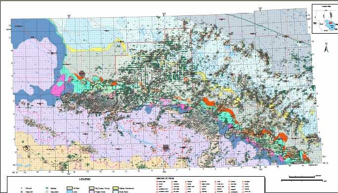
2 ~ 7, km 2 of Phanerozoiccover Total volume estimated at 6877 km 3 Over 3 Formations/Members produce Oil and Gas pools Depth of reservoirs ranging in depth from 41 to 29 meters.

3 HUDSON BAY ALBERTA BASIN ALBERTA MANITOBA EDMONTON SASKATCHEWAN PRINCE ALBERT SASKATOON CALGARY REGINA WINNIPEG MONTANA Arch HELENA Sweetgrass BRANDON WILLISTON BASIN BISMARCK NORTH DAKOTA PIERRE WYOMING SOUTH DAKOTA
4 Viking Shaunavon Bakken Birdbear Hot Plays.
5 Bakken. Bakken Image modified from Geoscape Southern Saskatchewan

6 From: The Encyclopedia of Saskatchewan at
7

8 Bakken Stratigraphy
 Continued regression and erosion of Unit A proximal prodeltadeposits, and deposition of the unit B delta-front sediments. 3.")
9 Bakken Depositional Model: ProgradingDelta: Forced or Normal Regression? 1.) Unit A deposited in a prograding, regressive setting 2.) Continued regression and erosion of Unit A proximal prodeltadeposits, and deposition of the unit B delta-front sediments. 3.) Unit C deposited in a transgressive setting

10
11 T1 T2 T3 T4 T T6 T7 T8 T9 T1 T11 T12 T13 T14 T1 T16 T1 T2 T3 T4 T T6 T7 T8 T9 T1 T11 T12 T13 T14 T1 T16 R3W1 R31 R32 R33 R34 R1W2 R2 R3 R4 R R6 R7 R8 R9 R1 R11 R12 R13 R14 R1 R16 R17 R18 R19 R2 R21 R22 R23 R24 R2 R3W1 R31 R32 R33 R1W2 R2 R3 R4 R R6 R7 R8 R9 R1 R11 R12 R13 R14 R1 R16 R17 R18 R19 R2 R21 R22 R23 R24 R2 m 1m 2m 3m 4m m 6m 7m 8m 9m 1m 11m 12m 13m 14m Horseshoe pattern Viewfield Contour Interval = m Bakken Producing Wells Kilometres Unit B Isopach
12 Viking. Image modified from Geoscape Southern Saskatchewan
13 Viking Isopach Viking Production W3 2W3 2W3 1W3 1W3 W3 3W2 2W2 2W2 1W2 1W2 W2 34W1 3W


")
, but has a")


14 Viking 1/ W3M 694.7m Viking Oil Play Complex Geology: Cretaceous fine grained sandstones and highly bioturbatedmuddy sandstones; highly bioturbated; multiple sea level rises and falls, regressive surfaces of erosion merging with transgressivesurfaces of erosion Oil Density: 84 KG/m 3 (API ~ 36 ) Light Oil Production since 19 s -Oil recovery factors are low (-1%), but has a large oil-in-place potential Production Since 27 over 866 horizontal wells with, multi-stage hydraulic fracturing drilled in areas of the reservoir where it was thought to have been depleted through vertical wells

15 T3 T3 T2 AB SK R2 R2 R1W3
16
17 Viking Opportunities Proven initial oil-in place: 2.3 billion barrels Recoverable Reserves based on old school technology (vertical wells and waterflood): 214 million barrels (9 per cent) Over 2 billion barrels presently unrecoverable Shallow target (6-7 metres) of 36 API oil Existing infrastructure
18 Shaunavon. Image modified from Geoscape Southern Saskatchewan
, which extends from Township 2-18 with most of the production")


19 W3 USHVN coquina ShaunavonReservoirs W3 L SHNVN moldic porosity ShaunavonFormation production occurs along a linear trend (ShaunavonOil Field Trend), which extends from Township 2-18 with most of the production centered around Ranges 18-2 West of the Third Meridian Initially renewed interest targeted the lower member, but now a lot of the interest has shifted back to the upper member, as well as the opportunity for multi zone production (both upper and lower) W3 USHVN xbedded sst In the last five years, horizontal wells in the Shaunavonhave produced around 12.3 million barrels of oil, and over 4 wells were drilled to exploit the clastic/carbonate upper member of the formation.

20 Upper ShaunavonOil Play Isopach Upper Shaunavon The Shaunavon: Mixed siliciclastic-carbonate reservoir shallow marine (coquina), and clasticchannel deposits To the end of 211, there have been 2,748 wells drilled into and at some time produced from the Shaunavon. Total production is around 387 million barrels of 22 API oil. Production as of May 211 is approximately 37 million barrels (9.6x1 6 m 3 ), accounting for 99% of the production from the Shaunavon Formation Typical porosity is 1-2%; permeability varies from generally 1md to greater than a Darcy
21 Isopach Lower Shaunavon Carbonate reservoir oolitic& fossiliferousshoals found in upper few metres porosity is vuggy to mouldic Porosity ranges from 1-28%; permeabilitiesfrom core analysis range from generally less than a millidarcy, but can be up to 64md Since 27, over 21 horizontal wells have been drilled into the low permeability reservoirs of the Lower Shaunavon, with production totaling over 4.26 million barrels
22 Birdbear. Image modified from Geoscape Southern Saskatchewan

23 Sub-Mesozoic Unconformity SubcropMap near Unity Saskatchewan


24 Pay Zone of well W3 subcropplay of wireline and core Perf. Zone 7m-73m Picture taken at 71.m Porosity ranges from 1-24%, average 2% K9 Permeability as high as 37mD Cumm. Production 1,1 bbl. of API 12 oil


25 Thin sections Well: W3 inter-particle porosity enhanced porosity by dissolution 3mm field of view 1.3mm field of view


26 Pay Zone of well W3 Off-bank play wireline and core Perf. Zone 91.m-913.m Picture taken at 911.m Porosity ranges from 11-27%, average 19% K9 Permeability as high as 173 md Cumm. Production 17,6 bbl, of API 9.6 oil
27 Number of Wells Drilled in the last five years that have Oil Production
28 Number of Wells Drilled in the last five years that have Oil Production

29 Saskatchewan Workhorses. Mississippian & Mannville
30 Cumulative Oil Production by 211 (Million Cubic Metres) Current Monthly Oil Production (Oct. 211) (Cubic Metres) 1, 2, 3, 4, Midale Bakken Sparky 69.4 Midale Roseray 66.2 Sparky Frobisher-Alida 6.7 Waseca Waseca 7.2 Viking Bakken 6.9 Cumming 964 Upper Shaunavon 6.8 Frobisher Frobisher 42.9 Frobisher-Alida Viking 27. Rosery 7844 Alida 21. Colony 6136 Tilston 17. General Petroleums 16.3 Lloydminster 1.2 Basal Mannville 1. Mclaren13.7 Cantuar12.9 Mannville12.7 Cummings12. Ratcliffe11.3 Dina1. All Mississippian Million Cubic Metres All Mannville 23.4 Million Cubic Metres U. Shaunavon 618 G.P. 689 Manville 336 Mclaren 4762 Shaunavon Cumming/Dina 446 Lloydminster Tilston36296 L. Shaunvon3431 Alida3217 All Mississippian -1,476 Cubic Metres All Mannville 777,673 Cubic Metres
31 Mississippian Subcrop Map


32
33 Intriguing plays.
34 Cumulative Oil Production by 211 (Million Cubic Metres) Current Monthly Oil Production (Oct. 211) (Cubic Metres) 1, 2, 3, 4, Midale Bakken Sparky 69.4 Midale Roseray 66.2 Sparky Frobisher-Alida 6.7 Waseca Waseca 7.2 Viking Bakken 6.9 Cumming 964 Upper Shaunavon 6.8 Frobisher Frobisher 42.9 Frobisher-Alida Viking 27. Rosery 7844 Alida 21. Colony 6136 Tilston 17. General Petroleums 16.3 Lloydminster 1.2 Basal Mannville 1. Mclaren13.7 Cantuar12.9 Mannville12.7 Cummings12. Ratcliffe11.3 Dina1. All Mississippian Million Cubic Metres All Mannville 23.4 Million Cubic Metres U. Shaunavon 618 G.P. 689 Manville 336 Mclaren 4762 Shaunavon Cumming/Dina 446 Lloydminster Tilston36296 L. Shaunvon3431 Alida3217 All Mississippian -1,476 Cubic Metres All Mannville 777,673 Cubic Metres
35 Number of Wells Drilled in the last five years that have Oil Production

36 Red River Producers T1 R2 R1 R1W2
37 1 2 ' 1 3 ' 1 4 ' 7 ' 6 ' Kilometres Kilometres Miles Miles 1 9 ' 11 ' 1 ' 1 7 ' 1 8 ' 16 ' 7 ' ISOPACH MAP OF THE RED RIVER STRATA IN IN SASKATCHEWAN 6 ' Contour Interval = m PETROLEUM GEOLOGY BRANCH Flin Flon ' 4 ' Regina Weyburn Estevan ' 1 13 ' 4 ' ' 3 2 ' 23 1 ' 12 ' 49 ' 8 W 1 8 MANITOBA Township Yorkton 7 31 S O U T H E R N E D G E O Ile-a-la-Crosse R La Ronge F P R E C A M B I A ' N S H I E L D 64 R P M E N T 63 1 K E E S C A 62 L A M E A D O W 61 6 Meadow Lake ' Lloydminster Prince Albert 47 3 ' 46 Hudson Bay 4 Melfort North Battleford Saskatoon ' ALBERTA ' Township Moose Jaw Swift Current ' ' ' ' 1 ' 1 4 ' To June 211, Red River reservoirs have produced 4 million m 3 (2.2 million bbls) of oil from 21 wells; average single well production is 2 x1 m 3 (12.8 million bbls). remain under-explored with only 674 wells penetrating the Red River in southeastern Saskatchewan (Tp1-23; Rge3W1-3W2). 1 6 ' 1 7 ' 1 8 ' MONTANA NORTH DAKOTA Range W 2 W 3
: produced 44,291 m 3 oil, 78,3 m 3 water in 77 DOP from 1963 to 26.")

38 3 Types of Reservoirs: Longview Flat Lake W2 387m Laminated dolomicritereservoir in LONGVIEW FLAT LAKE (used to be Lake Alma 1-14): produced 44,291 m 3 oil, 78,3 m 3 water in 77 DOP from 1963 to 26. Longview et al Midale V1U W2 Transitional facies. include oolitic grainstones, bioclastic grainstones/packston es, and thromboid and stromatoporoid boundstones. This well has produced m 3 oil and m 3 of water in 424 DOP to Jan. 1, 212.

39 3 Types of Reservoirs: NRK Minton 2HZ 1A D W2 Yeoman burrowmottled dolostone (Tyndall Stone equivalent) - produced 421,39 m 3 of oil and 133,27 m 3 of water in 3162 DOP to Jan. 1, 212 (from Yeoman faciesas well as the transitional and Lake Alma facies).
40 Petroleum Geologists SGS
41 Thank you!
4. Carboniferous Zone Play Results
 C H A P T E R F O U R 4. Carboniferous Zone Play Results 4. Geological Overview In the WCSB, there were two main depositional areas during Carboniferous time the Peace River Embayment in northwestern Alberta,
Reservoir Characteristics of the Birdbear Formation in West- Central Saskatchewan
 Reservoir Characteristics of the Birdbear Formation in West- Central Saskatchewan Chao Yang Petroleum Geology Branch Exploration and Geological Services Division Saskatchewan Ministry of Energy and Resources
6. Cretaceous Zone Play Results
 C H A P T E R S I X 6. Cretaceous Zone Play Results 6. Geological Overview The Mannville Group was deposited as a clastic wedge east of the mountain ranges. This wedge varies in thickness from 7 metres
Geology of the Gull Lake North ASP Flood, Upper Shaunavon Formation, Southwest Saskatchewan
 Geology of the Gull Lake North ASP Flood, Upper Shaunavon Formation, Southwest Saskatchewan By Sid Leggett, Husky Energy (sid.leggett@huskyenergy.com) Acknowledgements Husky Energy Members of the Gull
OIL TRENDS IN WESTERN CANADA 2004 to Present. October Introduction
 OIL TRENDS IN WESTERN CANADA 2004 to Present October 2006 Introduction In this review Canadian Discovery Ltd. (CDL) has analyzed oil industry activity, including recent discoveries and drilling activity
Core Analysis and Correlation to Seismic Attributes, Weyburn Midale Pool, Southeastern Saskatchewan
 Core Analysis and Correlation to Seismic Attributes, Weyburn Midale Pool, Southeastern Saskatchewan Nicole M. Pendrigh 1 Pendrigh, N.M. (2004): Core analysis and correlation to seismic attributes, Weyburn
East Gainsborough, Saskatchewan: a Prairie Evaporite salt dissolution and Mississippian erosional unconformity trap
 East Gainsborough, Saskatchewan: a Prairie Evaporite salt dissolution and Mississippian erosional unconformity trap Andre St.Onge* and Eric Strachan Upton Resources Inc., 3900, 205-5 th Avenue S.W., Calgary,
Preliminary Investigations of the Hudson Bay Area Coal Deposits
 Preliminary Investigations of the Hudson Bay Area Coal Deposits Jason Berenyi, Arden Marsh and Ron Leray Saskatchewan Ministry of Energy and Resources www.er.gov.sk.ca Introduction Introduction Manville
State A Marker Oil Production within the Willsiton Basin of Southeast Saskatchewan (Mississippian, Frobisher Beds)
") State A Marker Oil Production within the Willsiton Basin of Southeast Saskatchewan (Mississippian, Frobisher Beds) John Lake* Geological Services Inc., Swift Current, Saskatchewan, Canada lakegeol@saktel.net
State A Marker Oil Production within the Willsiton Basin of Southeast Saskatchewan (Mississippian, Frobisher Beds) John Lake* Geological Services Inc., Swift Current, Saskatchewan, Canada lakegeol@saktel.net
Williston Basin Architecture and Hydrocarbon Potential in Eastern Saskatchewan and Western Manitoba
 Williston Basin Architecture and Hydrocarbon Potential in Eastern Saskatchewan and Western Manitoba Kim Kreis, Benoit Beauchamp 1, Ruth Bezys 2 Carol Martiniuk 3, and Steve Whittaker Kreis, L.K., Beauchamp,
Devonian Petroleum Systems and Exploration Potential, Southern Alberta, Part 3 Core Conference
 Devonian Petroleum Systems and Exploration Potential, Southern Alberta, Part 3 Core Conference Andy Mort (1), Leonard Stevens (2), Richard Wierzbicki (2) Abstract Part 1: Devonian Petroleum Systems Dr.
High-resolution Sequence Stratigraphy of the Glauconitic Sandstone, Upper Mannville C Pool, Cessford Field: a Record of Evolving Accommodation
 Page No. 069-1 High-resolution Sequence Stratigraphy of the Glauconitic Sandstone, Upper Mannville C Pool, Cessford Field: a Record of Evolving Accommodation Thérèse Lynch* and John Hopkins, Department
How to Log Core (With Examples from the Williston Basin of Southeast Saskatchewan)
") How to Log Core (With Examples from the Williston Basin of Southeast Saskatchewan) D.M.Kent ( D.M.Kent Geological Consulting Ltd., Regina, Sask.), and J.H.Lake, (Lake Geological Services Inc, Swift Current,
How to Log Core (With Examples from the Williston Basin of Southeast Saskatchewan) D.M.Kent ( D.M.Kent Geological Consulting Ltd., Regina, Sask.), and J.H.Lake, (Lake Geological Services Inc, Swift Current,
Hydrocarbon Distribution in the Mannville Waseca Member, Edam Oil Field, West-central Saskatchewan
 Hydrocarbon Distribution in the Mannville Waseca Member, Edam Oil Field, West-central Saskatchewan Peter Hill 1 Information from this publication may be used if credit is given. It is recommended that
Glauconitic Oil Reservoirs in Southern Alberta Creating the Correct Geological Model to Guide Development Drilling
 Glauconitic Oil Reservoirs in Southern Alberta Creating the Correct Geological Model to Guide Development Drilling Brad Hayes* Petrel Robertson Consulting Ltd, Calgary, AB bhayes@petrelrob.com Lisa Griffith
Highstand Stacked Tidal Flat / Standing Water Evaporite Cycles of the Midale Evaporite in Southeast Saskatchewan, Mississippian Williston Basin*
 Highstand Stacked Tidal Flat / Standing Water Evaporite Cycles of the Midale Evaporite in Southeast Saskatchewan, Mississippian Williston Basin* J. H. Lake 1 and D. M. Kent 2 Search and Discovery Article
Abstract. 1. Introduction. Dan Kohlruss 1 and Kosta Stamatinos 2
 Preliminary Bulk Density Mapping of the Upper and Lower Bakken Member Shales of Southeastern Saskatchewan: A Potential Indicator for Oil Generation and Expulsion Dan Kohlruss 1 and Kosta Stamatinos 2 Kohlruss,
Facies Analysis of the Upper Devonian Lower Mississippian Bakken Formation, Southeastern Saskatchewan
 Facies Analysis of the Upper Devonian Lower Mississippian Bakken Formation, Southeastern Saskatchewan Dan Kohlruss and Erik H. Nickel Kohlruss, D. and Nickel, E. (2009): Facies analysis of the Upper Devonian
Bakken Project Phase I Southeastern Saskatchewan Phase II North Dakota
 Bakken Project Phase I Southeastern Saskatchewan Phase II North Dakota Geology, Hydrogeology and Reservoir Characterization Unconventional Oil? The Bakken Formation has fast become the hottest onshore
Devonian Isopach and Structure Maps: Initial Results of the IEA Weyburn CO 2 Monitoring and Storage Project Area
 Devonian Isopach and Structure Maps: Initial Results of the IEA Weyburn CO 2 Monitoring and Storage Project Area L.K. Kreis, P.L. Thomas, R.B. Burke 1, and S.G. Whittaker Kreis, L.K., Thomas, P.L., Burke,
Continuity and Compartmentalization of Viking Formation gas production from the Ricinus / Bearberry area of the Rocky Mountain Triangle Zone
 Page No. 001-1 Continuity and Compartmentalization of Formation gas production from the Ricinus / Bearberry area of the Rocky Mountain Triangle Zone David Halwas* (Senior Staff Geologist), Darryl Parry
Masila 1: Shallow shelf carbonate facies variability and secondary reservoir development - Saar Formation Masila block, Yemen
 Masila 1: Shallow shelf carbonate facies variability and secondary reservoir development - Saar Formation Masila block, Yemen Kent Wilkinson* Nexen Inc., Calgary, AB kent_wilkinson@nexeninc.com ABSTRACT
Lithological variation of Middle Bakken reservoirs in SE Saskatchewan: implications for optimizing multi-stage hydraulic fracturing
 Lithological variation of Middle Bakken reservoirs in SE Saskatchewan: implications for optimizing multi-stage hydraulic fracturing Hairuo Qing, Guoxiang Chi, Adam Sturiala Dept of Geology University of
Stratigraphy and Reservoir Characterization of the Upper Devonian Duperow Formation, Southeastern Saskatchewan
 Stratigraphy and Reservoir Characterization of the Upper Devonian Duperow Formation, Southeastern Saskatchewan Chao Yang 1 Parts of this publication may be quoted if credit is given. It is recommended
North Dakota Geological Survey
 Review of Hydrocarbon Production from the Stonewall and lower Interlake Formations: western North Dakota Williston Basin Timothy O. Nesheim North Dakota Geological Survey North Dakota Geological Survey
Delineating a sandstone reservoir at Pikes Peak, Saskatchewan using 3C seismic data and well logs
 Delineating a sandston reservoir at Pikes Peak Delineating a sandstone reservoir at Pikes Peak, Saskatchewan using 3C seismic data and well logs Natalia L. Soubotcheva and Robert R. Stewart ABSTRACT To
MIDDLE DEVONIAN PLAY MICHIGAN BASIN OF ONTARIO. Duncan Hamilton
 MIDDLE DEVONIAN PLAY MICHIGAN BASIN OF ONTARIO Duncan Hamilton 1 Middle Devonian Pools of the Michigan Basin 375+ Million Barrels Michigan 45+ million Barrels Ontario 2 Outline of Presentation History
Overview of Selected Shale Plays in New Mexico*
 Overview of Selected Shale Plays in New Mexico* Ron Broadhead 1 Search and Discovery Article #10627 (2014)** Posted August 18, 2014 *Adapted from presentation at RMAG luncheon meeting, Denver, Colorado,
Hydrocarbon Pools Of The Southeastern Great Slave Plain, Northwest Territories
 Hydrocarbon Pools Of The Southeastern Great Slave Plain, Northwest Territories Introduction E.P. Janicki* C.S. Lord Northern Geoscience Centre, Yellowknife, NWT ed_janicki@gov.nt.ca The geology of hydrocarbon
NXT Energy Solutions Inc.
 SFD Case Example:, Western Canada (Stratigraphic Trapping) Lower Cretaceous Fluvial channel system of the Mannville Group is one of the most prolific hydrocarbon bearing strata in the province of Alberta.
Unconventional Oil Plays Opportunity vs Risk
 Unconventional Oil Plays Opportunity vs Risk EnerCom s London Oil & Gas Conference 4 June 14, 2012 Sofitel London Danny D. Simmons 1000 BOPD - What a great well! 10,000 1,000 BOPD 100 10 12/2009 1/2010
UTILIZING PETROGRAPHIC DATA TO EXPLOIT MIDALE BED RESERVOIRS IN THE ALAMEDA WEST STEELMAN AREA OF THE WILLISTON BASIN IN SOUTHEAST SASKATCHEWAN
 UTILIZING PETROGRAPHIC DATA TO EXPLOIT MIDALE BED RESERVOIRS IN THE ALAMEDA WEST STEELMAN AREA OF THE WILLISTON BASIN IN SOUTHEAST SASKATCHEWAN Gary A. Posehn, Athena Resources Ltd., Calgary, Alberta gary.posehn@athenaresources.ca
John N. Fox, P.Eng. Michelle P.B. Nicolas, P.Geo. Manitoba Innovation, Energy and Mines Mineral Resources Division
 John N. Fox, P.Eng. Michelle P.B. Nicolas, P.Geo. Manitoba Innovation, Energy and Mines Mineral Resources Division APEGM Professional Development Seminar Winnipeg, Manitoba December 5, 2012 Geology and
Burrow-Mottled Carbonates in the Devonian Wabamun Formation, Pine Creek Gas Field, Alberta, Canada
 Page No. 142-1 Burrow-Mottled Carbonates in the Devonian Wabamun Formation, Pine Creek Gas Field, Alberta, Canada Gladys Fong Department of Earth and Atmospheric Sciences University of Alberta, Edmonton,
LOWER GRAND RAPIDS BITUMEN POOLS AT COLD LAKE, ALBERTA VARIATIONS IN STRATIGRAPHIC SETTING AND DEPOSITIONAL ENVIRONMENTS
 RAPIDS BITUMEN POOLS AT COLD LAKE, ALBERTA VARIATIONS IN STRATIGRAPHIC SETTING AND DEPOSITIONAL ENVIRONMENTS Brad J. Hayes, Petrel Robertson Consulting Ltd. Garrett M. Quinn, OSUM Oil Sands Corp. Summary
Reservoir Characterization for the Application of ASP Flood Technology in the Bridgeport Sandstone in Lawrence Field, Illinois*
 Reservoir Characterization for the Application of ASP Flood Technology in the Bridgeport Sandstone in Lawrence Field, Illinois* Nathan D. Webb 1, Vineeth Madhavan 1, John P. Grube 1, Curt S. Blakley 1,
Elm Coulee Oil Field Richland County, Montana. Bakken Oil Well FRAC TREATMENT
 Elm Coulee Oil Field Richland County, Montana Bakken Oil Well FRAC TREATMENT LOCATION MAP ELM COULEE FIELD RICHLAND COUNTY, MONTANA SASKATCHEWAN MANITOBA WILLISTON BASIN Poplar Dome Nesson Ant Brockton-Froid
The Origin of Matrix and Fracture Mega- Porosity in a Carbonate Bitumen Reservoir, Grosmont Formation, Saleski, Alberta T 85 R 19W4M
 The Origin of Matrix and Fracture Mega- Porosity in a Carbonate Bitumen Reservoir, Grosmont Formation, Saleski, Alberta T 85 R 19W4M Kent Barrett, Dr John Hopkins, Ken Wilde and Marnie Connelly Oct 2/07
Have we run out of conventional plays in the WCSB?
 Have we run out of conventional plays in the WCSB? Md S Islam, P.Geo. Summary The Alberta Deep Basin is one of the most productive areas of Western Canadian Sedimentary Basin (WCSB), which contains the
Dakota Sandstone. of the Moxa Arch and Surrounding Green River Basin
 Dakota Sandstone of the Moxa Arch and Surrounding Green River Basin Dakota Sandstones of the Green River Basin Overview The Dakota sandstones of the Moxa Arch and surrounding Green River Basin remain attractive
Sedimentary and Stratigraphic Analysis of the Viking Sand in the Edgerton/Wainwright Area, Central Alberta* By Russell Walz 1
 Sedimentary and Stratigraphic Analysis of the Viking Sand in the Edgerton/Wainwright Area, Central Alberta* By Russell Walz 1 Search and Discovery Article #50030 (2006) Posted June 25, 2006 *Extended abstract
Stephanie B. Gaswirth and Kristen R. Mara
 U.S. Geological Survey Assessment of Undiscovered Resources in the Bakken and Three Forks Formations, Williston Basin, North Dakota, Montana, and South Dakota, 2013 Stephanie B. Gaswirth and Kristen R.
Canadian Bakken IOR/CO 2 Pilot Projects
 Canadian Bakken IOR/CO 2 Pilot Projects Richard Baker, Leon De Villiers, Crystal Lok, Tim Stephenson Baker Hughes Presented at the 20 th Annual CO 2 Flooding Conference December 11-12, 2014 Midland, Texas
Bakken/Torquay Development: A Manitoba Update. Dan Barchyn
 Bakken/Torquay Development: A Manitoba Update Dan Barchyn Outline History of Bakken/Torquay Development in Manitoba Examples of different play types: Daly Pools: Finding sweet spots in an area of ubiquitous
The Sequence Stratigraphic and Paleogeograhic Distribution of Reservoir-Quality Dolomite, Madison Formation, Wyoming and Montana
 The Sequence Stratigraphic and Paleogeograhic Distribution of Reservoir-Quality Dolomite, Madison Formation, Wyoming and Montana TAURY SMITH AND GREGOR EBERLI The primary aim of this study is to show the
Structure and Isopach Mapping of the Lower Cretaceous Dina Member of the Mannville Group of Northwestern Saskatchewan
 Structure and Isopach Mapping of the Lower Cretaceous Dina Member of the Mannville Group of Northwestern Saskatchewan Dan Kohlruss, Per Kent Pedersen 1, and Guoxiang Chi 2 Kohlruss, D., Pedersen, P.K.,
The McCully gas field in southern New Brunswick was discovered in the year 2000 on a joint drilling exploration venture by Corridor Resources Inc.
 1 The McCully gas field in southern New Brunswick was discovered in the year 2000 on a joint drilling exploration venture by Corridor Resources Inc. and Potash Corporation of Saskatchewan. Located about
Tight Gas in Western Canada: An Important and Continuing Component of Overall Supply. Agenda
 Tight Gas in Western Canada July 25 Tight Gas in Western Canada: An Important and Continuing Component of Overall Supply R.K. (Bob) Dixon, P.Eng. Unconventional Gas Conference, Houston July 26, 25 www.forwardenergy.ca
2016 U.S. Geological Survey Assessment of Continuous Oil and Gas Resources in the Mancos Shale of the Piceance Basin
 2016 U.S. Geological Survey Assessment of Continuous Oil and Gas Resources in the Mancos Shale of the Piceance Basin U.S. Department of the Interior U.S. Geological Survey Uinta-Piceance Province Colorado
GeoCanada 2010 Working with the Earth
 Lithofacies Identification and the Implications for SAGD Well Planning in the McMurray Formation, Christina Lake Area, Alberta Travis Shackleton*, Robert Gardner, Sung Youn, Grace Eng and Lori Barth Cenovus
Optimizing Completions within the Montney Resource Play Mike Seifert, Mark Lenko, Joshua Lee Canadian Discovery Ltd.
 URTeC: 2139640 Optimizing Completions within the Montney Resource Play Mike Seifert, Mark Lenko, Joshua Lee Canadian Discovery Ltd. Introduction The Montney resource play covers 57,000 square miles from
Devonian Three Forks Formation, Manitoba (NTS 62F, parts of 62G, K): preliminary hydrocarbon and stratigraphic investigations by M.P.B.
: preliminary hydrocarbon and stratigraphic investigations by M.P.B.") GS-17 Devonian Three Forks Formation, Manitoba (NTS 62F, parts of 62G, K): preliminary hydrocarbon and stratigraphic investigations by M.P.B. Nicolas Nicolas, M.P.B. 2007: Devonian Three Forks Formation,
GS-17 Devonian Three Forks Formation, Manitoba (NTS 62F, parts of 62G, K): preliminary hydrocarbon and stratigraphic investigations by M.P.B. Nicolas Nicolas, M.P.B. 2007: Devonian Three Forks Formation,
HISTORY OF HARTZOG DRAW FIELD
 7 th ANNUAL WYOMING CO2 CONFERENCE HISTORY OF HARTZOG DRAW FIELD 11 JULY 2013 HARTZOG DRAW INTRODUCTION WELCOME Click to edit Master YOU ARE title HERE! style 3 TERRAIN Click to edit / SCENIC Master VIEW
Application for Enhanced Oil Recovery Waterflood Project - Daly Unit No. 6
 October 25, 2013 SUBJECT Lodgepole Formation Daly Sinclair Lodgepole D (01 59D) Daly Sinclair Field, Manitoba Proposed Unitization of Daly Unit No. 6 S/2 22-9-29W1 Application for Enhanced Oil Recovery
PROPOSED DALY UNIT NO. 14 APPLICATION FOR ENHANCED OIL RECOVERY WATERFLOOD PROJECT BAKKEN FORMATION DALY, MANITOBA
 PROPOSED DALY UNIT NO. 14 APPLICATION FOR ENHANCED OIL RECOVERY WATERFLOOD PROJECT BAKKEN FORMATION DALY, MANITOBA September 1, 2015 Corex Resources Ltd. 1 Table of Contents INTRODUCTION... 4 SUMMARY...
EVALUATION OF KEY FACTORS AFFECTING SUCCESSFUL OIL PRODUCTION IN THE BAKKEN FORMATION, NORTH DAKOTA. Technology Status Assessment.
 EVALUATION OF KEY FACTORS AFFECTING SUCCESSFUL OIL PRODUCTION IN THE BAKKEN FORMATION, NORTH DAKOTA Technology Status Assessment Prepared by: James A. Sorensen Senior Research Manager Energy & Environmental
Steve Whittaker, Petroleum Technology Research Centre Stephen Bend, University of Regina Ben Rostron, University of Alberta Gavin Jensen, Ministry of
 Steve Whittaker, Petroleum Technology Research Centre Stephen Bend, University of Regina Ben Rostron, University of Alberta Gavin Jensen, Ministry of Energy & Resources Williston Basin Petroleum Conference
Williston Basin Architecture and Hydrocarbon Potential: A Targeted Geoscience Initiative Project 1
 Williston Basin Architecture and Hydrocarbon Potential: A Targeted Geoscience Initiative Project 1 S.G. Whittaker Whittaker, S.G. (2005): Williston Basin architecture and hydrocarbon potential: A Targeted
The unknown giants - low-permeability shallow gas reservoirs of southern Alberta and Saskatchewan, Canada.
 The unknown giants - low-permeability shallow gas reservoirs of southern Alberta and Saskatchewan, Canada. Shaun O'Connell* Belfield Resources Inc., Calgary belfield@shaw.ca ABSTRACT The gas reserves contained
Testing of the Strawn Sand, White Hat 20#3, Mustang Prospect, Permian Basin, Texas
 Date: 11 April 2019 ASX Code: WEL Directors John Kopcheff Non-Executive Chairman Neville Henry Managing Director Peter Allchurch Non-Executive Director Larry Liu Non-Executive Director Lloyd Flint Company
Investigating Geological Storage of Greenhouse Gases in Southeastern Saskatchewan: The IEA Weyburn CO 2 Monitoring and Storage Project 1
 Investigating Geological Storage of Greenhouse Gases in Southeastern Saskatchewan: The IEA Weyburn CO 2 Monitoring and Storage Project 1 Steve Whittaker Whittaker, S.G. (2004): Investigating geological
Origin and Evolution of Formation Waters in the West-Central Part of the Alberta Basin
 Page No. 004-1 Origin and Evolution of Formation Waters in the West-Central Part of the Alberta Basin Karsten Michael* University of Alberta, 1-26 ESB, Edmonton, AB T6G 2E3 karsten@ualberta.ca and Stefan
THE NEXT WAVE IN THE ILLINOIS BASIN
 THE NEXT WAVE IN THE ILLINOIS BASIN Themes Low Risk High Margins Opportunity through Joint Venture Ron Prefontaine ron@strata-x.com www.strata-x.com TSX.V: SXE ASX: SXA 2 Key Management with operations
DEVONIAN OIL AND GAS PLAYS OF THE MICHIGAN BASIN
 DEVONIAN OIL AND GAS PLAYS OF THE MICHIGAN BASIN William B. Harrison, III Michigan Geological Repository for Research and Education (MGRRE) Western Michigan University-Michigan Geological Survey 1 Devonian
The Bakken. A Non-Shale Shale Play. August 2010
 The Bakken A Non-Shale Shale Play August 2010 ConocoPhillips Unconventional Resource Experience in North America CBM San Juan Drunkards Wash Uinta Powder River Horseshoe Canyon Manville Shale Barnett Haynesville
Update - Testing of the Strawn Sand, White Hat 20#3, Mustang Prospect, Permian Basin, Texas
 Date: 15 April 2019 ASX Code: WEL Directors John Kopcheff Non-Executive Chairman Neville Henry Managing Director Peter Allchurch Non-Executive Director Larry Liu Non-Executive Director Lloyd Flint Company
The Green River and Wasatch formations in the Lake Uinta, and
 DCA ~280m Oil-stained Sandstone Consortium Proposal: Lacustrine Reservoirs from Deep to Shallow: Facies Distribution, Architecture, and Source Rock Formation Green River Formation, Utah & Colorado Microbial
Southern Alberta Basin Multi-zone Oil Prospects
 Southern Alberta Basin Multi-zone Oil Prospects May 28, 2012 Advisory Disclaimer Statements in this presentation may contain forward-looking information. Forward looking statements or information are based
Reservoir Description using Hydraulic Flow Unit and Petrophysical Rock Type of PMT Carbonate Early Miocene of Baturaja Formation, South Sumatra Basin*
 Reservoir Description using Hydraulic Flow Unit and Petrophysical Rock Type of PMT Carbonate Early Miocene of Baturaja Formation, South Sumatra Basin* Jaka Radiansyah 1, Teddy E. Putra 1, Rienno Ismail
Geologic Considerations of Shallow SAGD Caprock; Seal Capacity, Seal Geometry and Seal Integrity, Athabasca Oilsands, Alberta Canada
 Geologic Considerations of Shallow SAGD Caprock; Seal Capacity, Seal Geometry and Seal Integrity, Athabasca Oilsands, Alberta Canada Gordon T. Stabb, Michael Webb Durando Resources Corp, Suncor Energy
The Giant Continuous Oil Accumulation in the Bakken Petroleum System, Williston Basin
 The Giant Continuous Oil Accumulation in the Bakken Petroleum System, Williston Basin Stephen A. Sonnenberg Department of Geology and Geological Engineering Colorado School of Mines Williston Basin Conference
Assessment of Shallow Biogenic Gas Resources In Montana
 Page No. 45-1 Assessment of Shallow Biogenic Gas Resources In Montana J.L. Ridgley *, T.C. Hester, S.M. Condon, T. Cook, L.O. Anna, P.G. Lillis, E.L. Rowan U.S. Geological Survey, Denver, CO 8225 ridgley@usgs.gov
Ladyfern, N.E.B.C.: Major Gas Discovery in the Devonian Slave Point Formation
 Page No. 112-1 Ladyfern, N.E.B.C.: Major Gas Discovery in the Devonian Slave Point Formation Thomas Boreen and Kelvin Colquhoun, Apache Canada Ltd., Calgary, Alberta ABSTRACT The Upper Devonian Slave Point
Geology and Bitumen Recovery Potential of the Grosmont Formation, Saleski, Alberta
 Geology and Bitumen Recovery Potential of the Grosmont Formation, Saleski, Alberta CHOA Technical Luncheon Reservoir & Production Nexen Conference Centre 801-7 Ave SW, Plus 15 Level Kent Barrett & Mauro
Facies Analysis of the Lower Cretaceous Wilrich Member (Lower Falher) of the Spirit River Formation.
 of the Spirit River Formation.") Facies Analysis of the Lower Cretaceous Wilrich Member (Lower Falher) of the Spirit River Formation. Kerrie L. Bann, Ichnofacies Analysis Inc. and Daniel J. K. Ross, Tourmaline Oil Corp. Historically,
Facies Analysis of the Lower Cretaceous Wilrich Member (Lower Falher) of the Spirit River Formation. Kerrie L. Bann, Ichnofacies Analysis Inc. and Daniel J. K. Ross, Tourmaline Oil Corp. Historically,
Drought Characterization. Examination of Extreme Precipitation Events
 Drought Characterization Examination of Extreme Precipitation Events Extreme Precipitation Events During the Drought For the drought years (1999-2005) daily precipitation data was analyzed to find extreme
Integrated 3D Geological Model of the Mississippian Devonian Bakken Formation, Elm Coulee, Williston Basin: Richland County, Montana
 Integrated 3D Geological Model of the Mississippian Devonian Bakken Formation, Elm Coulee, Williston Basin: Richland County, Montana Adrian Almanza Colorado School of Mines Outline Location Stratigraphy
The Capitan Aquifer - Ellenburger Production Wells Geothermal Engine Source?
 GEOTHERMAL ENERGY UTILIZATION ASSOCIATED WITH OIL & GAS DEVELOPMENT June 17-18, 2008 Southern Methodist University Dallas, Texas The Capitan Aquifer - Ellenburger Production Wells Geothermal Engine Source?
OIL AND GAS PLAYS OF THE MICHIGAN BASIN, SOUTHERN ONTARIO. Terry Carter, Consulting Geologist London, Ontario
 OIL AND GAS PLAYS OF THE MICHIGAN BASIN, SOUTHERN ONTARIO Terry Carter, Consulting Geologist London, Ontario 1 Ontario Petroleum Industries Oil and Natural Gas 1250 oil wells, 1200 gas wells, annual production
Subsurface Mapping 1 TYPES OF SUBSURFACE MAPS:- 1.1 Structural Maps and Sections: -
 Subsurface Mapping The purpose of subsurface mapping in the geology of petroleum Is to find traps that contain oil and gas pools and the information obtained from wells forms the heart of the data upon
Geosciences Career Pathways (Including Alternative Energy)
") Geosciences Career Pathways (Including Alternative Energy) Shale Carbonates Clastics Unconventionals Geology Characterization and Production Properties of Gas Shales Geomechanics in International Shale
Geosciences Career Pathways (Including Alternative Energy) Shale Carbonates Clastics Unconventionals Geology Characterization and Production Properties of Gas Shales Geomechanics in International Shale
Lower Skinner Valley Fill Sandstones: Attractive Exploration Targets on the Northeast Oklahoma Platform*
 Lower Skinner Valley Fill Sandstones: Attractive Exploration Targets on the Northeast Oklahoma Platform* By Jim Puckette 1 Search and Discovery Article #10050 (2003) *Adapted from presentation to Tulsa
Oil Shales in Saskatchewan
 Oil Shales in Saskatchewan Melinda Yurkowski Petroleum Geology Branch Bruce Wilhelm Energy Development and Climate Change Saskatchewan Energy and Resources Pasquia Hills Image modified from Geoscape Southern
entered a rapid development phase. Annual increased proven reserves are above 500 billion cubic meters (bcm) from 2003, and annual natural gas product
 from 2003, and annual natural gas product") (), entered a rapid development phase. Annual increased proven reserves are above 500 billion cubic meters (bcm) from 2003, and annual natural gas production has increased from 50bcm in 2000 to nearly
(), entered a rapid development phase. Annual increased proven reserves are above 500 billion cubic meters (bcm) from 2003, and annual natural gas production has increased from 50bcm in 2000 to nearly
Controls on facies distributions in the Charlie Lake Formation, Peace River Arch, Alberta
 Controls on facies distributions in the Charlie Lake Formation, Peace River Arch, Alberta E.L. Percy 12, C. Frostad 2, A. Juska 2, C. Schmidt 2, C. Sitzler 2, and J.P. Zonneveld 3 University of Calgary,
Hydrocarbon Potential of the Marginal Fields in Niger Delta Oza Field, a case study*
 Hydrocarbon Potential of the Marginal Fields in Niger Delta Oza Field, a case study* J.N. Sahu 1, C.H.V. Satya Sai 1, V. Chintamani 1 and C. Vishnu Vardhan 1 Search and Discovery Article #20182 (2012)*
Carbonates vs Clastics How the Differences Impact our SAGD Assessments. Caralyn Bennett, P. Eng. July 6, 2011
 Carbonates vs Clastics How the Differences Impact our SAGD Assessments Caralyn Bennett, P. Eng. July 6, 2011 Source: Alberta Geological Survey Formations Prospective for Oil Sands Carbonates Clastics
Central North Dakota Shallow Gas Potential A Historical Perspective
 Central Shallow Gas Potential A Historical Perspective David W. Fischer Fischer Oil and Gas, Inc. Fred J. Anderson Department CURRENT ND ACTIVITIES ONLINE BIBLIOGRAPHY OF SHALLOW GAS REFERENCES ONLINE
Fossilized worm burrows influence the resource quality of porous media
 Fossilized worm burrows influence the resource quality of porous media Murray K. Gingras, Carl A. Mendoza, and S. George Pemberton ABSTRACT Burrow-associated, selective dolomitization in the Yeoman Formation
The North Dakota Bakken Play - Observations. Julie A. LeFever North Dakota Geological Survey
 The North Dakota Bakken Play - Observations Julie A. LeFever North Dakota Geological Survey The Basics Bakken Formation in North Dakota Upper & Lower Black Shale World Class Source Rock TOC s as high as
Aptian/Albian Reservoir Development in the Jeanne d Arc Basin, Offshore Eastern Canada
 Aptian/Albian Reservoir Development in the Jeanne d Arc Basin, Offshore Eastern Canada Jonathan Marshall, Statoil Canada Ltd. Calgary, Alberta, Canada. jomars@statoil.com Introduction: The Jeanne d Arc
Reservoir Characterization of Plover Lake Heavy-Oil Field
 Reservoir Characterization of Plover Lake Heavy-Oil Field Larry Lines* Chorus, University of Calgary, Calgary, Alberta, Canada lrlines@ucalgary.ca Joan Embleton, Mathew Fay, Steve Larter, Tony Settari
Fusselman/Devonian Study. of the Midland Basin, Texas
 Fusselman/Devonian Study of the Midland Basin, Texas Fusselman-Devonian Study of the Midland Basin, Texas Overview The Fusselman-Devonian study of the Midland Basin is designed to enhance both exploration
Evaluating Geological Formations and Managing Ground-Water Resources: Can We Afford the Effort?
 Evaluating Geological Formations and Managing Ground-Water Resources: Can We Afford the Effort? Stanley T. Paxton & Todd Halihan Oklahoma State University GSA Annual Meeting Salt Lake City, Utah 16-19
Appraising a late-middle-aged Brent Group field
 Appraising a late-middle-aged Brent Group field Reservoir learnings after nearly 20 years of Pelican field production Jill Marriott The Pelican Field The Pelican oil field is nearly 20 years old It is
Carboniferous Stoddart Group: An integrated approach
 Carboniferous Stoddart Group: An integrated approach Abu Yousuf*, Department of Geoscience, University of Calgary, Calgary, Alberta yousufabu@hotmail.com and Charles M. Henderson, Department of Geoscience,
Unconventional Shale Plays in MT
 Unconventional Shale Plays in MT A Look at the Geology & Development of the Bakken and Heath Formations Jay Gunderson Montana Bureau of Mines and Geology Why Shales? Traditional Source Rocks Mostly clays
Reservoir Characterization of the Swan Hills Eastern Platform Trend; a Multi-disciplinary Approach in Building an Applied Model
 Reservoir Characterization of the Swan Hills Eastern Platform Trend; a Multi-disciplinary Approach in Building an Applied Model Thanos A. Natras*, Arcan Resources Ltd., Calgary, Alberta tnatras@arcanres.com
EAS 233 Geologic Structures and Maps Winter Miscellaneous practice map exercises. 1. Fault and separation:
 Miscellaneous practice map exercises 1. Fault and separation: With respect to Map 1, what are (a) the orientation of the fault, and (b) the orientation of bedding in the units cut by the fault. (c) Mark
Time-lapse seismic modelling for Pikes Peak field
 Time-lapse seismic modelling for Pikes Peak field Ying Zou*, Laurence R. Bentley and Laurence R. Lines University of Calgary, 2500 University Dr, NW, Calgary, AB, T2N 1N4 zou@geo.ucalgary.ca ABSTRACT Predicting