Central North Dakota Shallow Gas Potential A Historical Perspective
|
|
|
- Toby Hood
- 5 years ago
- Views:
Transcription
1 Central Shallow Gas Potential A Historical Perspective David W. Fischer Fischer Oil and Gas, Inc. Fred J. Anderson Department
2 CURRENT ND ACTIVITIES ONLINE BIBLIOGRAPHY OF SHALLOW GAS REFERENCES ONLINE DATABASE OF SHALLOW NATURAL GAS OCCURRENCES IN NORTH DAKOTA CRETACEOUS STRATIGRAPHY AND STRUCTURAL GEOLOGY RELATIONSHIPS OF SHALLOW GAS OCCURRENCE AND GROUND-WATER GEOCHEMISTRY Department
3 Department

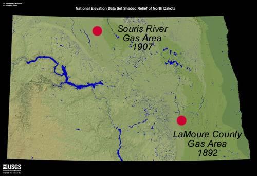
4 LaMoure County Gas Producing Area 1892 gas production was reported near Edgeley ND Production was a byproduct, associated artesian water flow from a Cretaceous sandstone Department

5 Sufficient gas was produced to supply ranches, farms and at least one municipality with a quality source of energy. Problem with the corrosive nature of water. Department
 up to 20 gallons/hr. Gas was dissolved in water and production proportionate to water flow rates.")
6 Cretaceous Newcastle fm (Muddy equivalent). Sandstone from approx depth. Early flow rates (gas) unknown. Later flow rates (gas) up to 20 gallons/hr. Gas was dissolved in water and production proportionate to water flow rates. RESERVOIR Department
 GAS")
7 No analysis available. Primarily methane (Hard 1923) GAS Department
8 It is the equal of gas selling in many cities up to $1.50 per 1000 feet. The free escape of all gas into the air seems inexcusable in this region of excessively high priced fuels. Hard (1923) Gas production declined and finally ended with continued mismanagement and exploitation of the NewCastle water resource. Department

9 Souris River Gas Producing Area 1907 gas discovered 9 miles south of Westhope Gas production associated with artesian water flow from glacial sediments Department
10 BOTTINEAU GAS FIELD DISCOVERY WELL: Great Northern Oil-Gas-Pipeline Company Parker farm: 9 miles south of Westhope Department


11 BOTTINEAU GAS FIELD: DISCOVERY Clastic reservoir -sand in glacial outwash Associated with artesian water flow Depth: psi* Flowed 2,000,000 cfgpd* *After Barry 1908 Department
12 RESERVOIR Reservoir thick* Sand; medium to fine grained, rounded, and of a greenish black color, due to an admixture of decomposing carbonaceous matter. * Found at base of glacial outwash *after Barry 1908 Department
13 Parker farm discovery well: S10-T161N-R80W Reference Log S22-T162N-R81W Department


14 BOTTINEAU GAS FIELD Great Northern Oil Gas & Pipeline Company Purchased additional leases Promoted drilling of wells Department
15 Department
16 Sufficient gas was produced to supply some local municipalities and farms. Department
17 Gas Properties* 886 BTU 82.7 % Methane 0.2 % Ethane 12.4 % Nitrogen 0.5 % Hydrogen 1.2 % Carbon Monoxide *After Barry 1908 Department
 Gas has blue color Gas had an odor similar")

18 Gas Properties (Contd.) Gas has blue color Gas had an odor similar to that of given off during distillation of lignite Department 14th Williston Basin Petroleum Conference & Prospect Expo
19 Two fields were discovered in a later exploration effort Department
20 Department
21 1953 Field Discovery Discovered in 1953 S21-T161N-R84W Depth: Initial production:70,000 cfgpd ¾ choke; FTP 80 psi; SIP 106 psi 5 nonproducing offsets Water productive/ loss of sand? Department
22 Department
23 Maxbass Field Discovered in 1957 S35-T161N-R81W Initial potential 10,000 cfgpd Open hole completion: FTP not reported SIP 77 psi Department
24 Maxbass Field No offsets Cum: 598,000 cfg w/no water in 10 months of production Department
25 Production History Department
26 Production declined and ended with water reservoir development and reservoir pressure decline There has been no recent exploration effort Department
27 REGIONAL GEOLOGY Department
28 -located in glaciated portion of ND Department

29 -within boundary of Glacial Lake Souris Department

30 -structural control? Department
31 Rapid Variation in Stratigraphy Department
32 Parker farm reference Log Note well developed sand section at base of well Trapped by overlying glacial clay Reference to carbonaceous sediments Department
33 Approx. 1 mile away Basal sand missing Department
34 At present there have been are 2 theories put forward for a source for the gas. Department

35 SOURCE : GLACIAL OUTWASH Organic materials from Lake Souris Department

36 SOURCE : MIGRATED Leakage from belowalong pre-existing zones of weakness Thin zones of organics in Hell Creek & Fox Hills Department
37 Natural Gas Production from Glacial Outwash in North Central More questions than conclusions additional work/data/wells to understand controlling factors. - when was the gas generated? - is structure needed? - how important is stratigraphy? - water chemisty? - is there still potential for economic production? Department
38 CONTACT INFORMATION Fred Anderson, NDGS, 600 East Boulevard Avenue Bismarck, ND (701) David W. Fischer, Fischer Oil and Gas, Inc., rd Street South, Grand Forks,, (701) Department

 328-8010 The Wilson M.")

39 NORTH DAKOTA GEOLOGICAL SURVEY Department and Division Main Offices Street Address: 1016 E. Calgary Ave., Bismarck ND Mailing Address: 600 East Boulevard Avenue, Bismarck ND Telephone: (701) FAX: (701) The Wilson M. Laird Core & Sample Library Office Hours: Monday - Friday, 8am-12pm and 1pm - 5pm Paleontology Lab P.O. Box 8156 University Station Grand Forks, ND Telephone: (701) FAX: (701) Street Address: 612 East Boulevard Avenue, Bismarck, ND Mailing Address: 600 East Boulevard Avenue, Bismarck ND Telephone: (701) FAX: (701) Contact: fjanderson@nd.gov Department
IN SOUTH DAKOTA PAST, PRESENT, AND FUTURE. GERALD (MACK) McGILLIVRAY OCTOBER 8-9, 2008
 McGILLIVRAY OCTOBER 8-9, 2008") SHALLOW GAS EXPLORATION & PRODUCTION IN SOUTH DAKOTA PAST, PRESENT, AND FUTURE BY GERALD (MACK) McGILLIVRAY 2009 ROCKY MOUNTAIN UNCONVENTIONAL GAS CONFERENCE OCTOBER 8-9, 2008 HISTORY OF SHALLOW GAS IN
SHALLOW GAS EXPLORATION & PRODUCTION IN SOUTH DAKOTA PAST, PRESENT, AND FUTURE BY GERALD (MACK) McGILLIVRAY 2009 ROCKY MOUNTAIN UNCONVENTIONAL GAS CONFERENCE OCTOBER 8-9, 2008 HISTORY OF SHALLOW GAS IN
=%REPORT RECONNAISSANCE OF CHISHOLM LAKE PROSPECT. October 25, 1977
 =%REPORT ON FIELD RECONNAISSANCE OF CHISHOLM LAKE PROSPECT October 25, 1977 Bruce D. Vincent Imperial Oil Limited, Minerals - Coal, CALGARY, ALBERTA CHISHOLM LAKE PROSPECT Introduction The Chisholm Lake
Atlantic Rim Coalbed Methane Play: The Newest SuccessfulCBM Play in the Rockies
 Atlantic Rim Coalbed Methane Play: The Newest SuccessfulCBM Play in the Rockies Robert A. Lamarre Lamarre Geological, Denver, Colorado Stephen K. Ruhl Anadarko Petroleum Corporation, The Woodlands, Texas
DENR s Oil and Gas Initiative. Legislative briefing March 7, 2011 by DENR s Geological Survey Program
 DENR s Oil and Gas Initiative Legislative briefing March 7, 2011 by DENR s Geological Survey Program South Dakota DOES have exploration for and production of oil and gas Taken from http://denr.sd.gov/des/og/producti.aspx
region includes nine states and four provinces, covering over 1.4 million square miles. The PCOR Partnership
 Overview of Phase II PCOR Partnership MVA Activities IEAGHG Monitoring Network Meeting Natchez, MS May 6-8, 2010 Steven A. Smith, Energy & Environmental Research Center The Plains CO 2 Reduction (PCOR)
Ground-Water Exploration in the Worthington Area of Nobles County: Summary of Seismic Data and Recent Test Drilling Results
 Ground-Water Exploration in the Worthington Area of Nobles County: Summary of Seismic Data and Recent Test Drilling Results Jim Berg and Todd Petersen Geophysicists, DNR Waters January 2000 Table of Contents
RELINQUISHMENT REPORT. License P1546 Block April 2009
 RELINQUISHMENT REPORT License P1546 Block 110-01 14 April 2009 Sherritt International Oil and Gas Limited 2000, 425-1 st street S.W., Calgary, Alberta Canada T2P 3L8 Telephone (403) 260-2900 Fax (403)
Utah s s Oil Shale Deposits: Stratigraphy and Resource Evaluation
 Utah s s Oil Shale Deposits: Stratigraphy and Resource Evaluation Michael D. Vanden Berg Utah Geological Survey 27 th Oil Shale Symposium October 2007 Outline 1) Utah Oil Shale Database 2) Historical oil
Goldsource Completes Winter Drill Program At Border; 34 Holes Contain Aggregate Coal Intercepts Ranging From 10 to 100 Meters
 Goldsource Completes Winter Drill Program At Border; 34 s Contain Coal Intercepts Ranging 10 to 100 Meters TSX-V: GXS For Immediate Release VANCOUVER, B.C. April 7, 2009 Goldsource Mines Inc. ( Goldsource
Mineral activities within Rich County, Utah
 Natural Resources and Environmental Issues Volume 14 Bear Lake Basin Article 10 1-1-2007 Mineral activities within Rich County, Utah Patsy Palacios SJ & Jessie E Quinney Natural Resources Research Library,
Petroleum Systems (Part One) Source, Generation, and Migration
 Source, Generation, and Migration") Petroleum Systems (Part One) Source, Generation, and Migration GEOL 4233 Class January 2008 Petroleum Systems Elements Source Rock Migration Route Reservoir Rock Seal Rock Trap Processes Generation Migration
Petroleum Systems (Part One) Source, Generation, and Migration GEOL 4233 Class January 2008 Petroleum Systems Elements Source Rock Migration Route Reservoir Rock Seal Rock Trap Processes Generation Migration
Steve Cumella 1. Search and Discovery Article # (2009) Posted July 30, Abstract
 Posted July 30, Abstract") AV Geology of the Piceance Basin Mesaverde Gas Accumulation* Steve Cumella 1 Search and Discovery Article #110106 (2009) Posted July 30, 2009 *Adapted from oral presentation at AAPG Annual Convention,
AV Geology of the Piceance Basin Mesaverde Gas Accumulation* Steve Cumella 1 Search and Discovery Article #110106 (2009) Posted July 30, 2009 *Adapted from oral presentation at AAPG Annual Convention,
Witwatersrand-type Gold
 Pardo The Pardo JV Project, Joint Venture Ontario Witwatersrand-type Gold March 2015 TSX.V: EDG Corporate Disclosure The information contained herein, while obtained from sources which we believe are reliable,
TIARO COAL JOINT VENTURE IRWIN RIVER COAL & COAL SEAM GAS QUEENSLAND TCJV AND WEST AUSTRALIAN COAL SEAM GAS PROJECT
 Suite 2, Mezanine Level, 35-37 Havelock Street WestPerth WA 6000 Telephone (08) 9481 8668 Facsimile: (08) 9322 7211 ASX ANNOUNCEMENT/MEDIA RELEASE 30th September 2008 TIARO COAL JOINT VENTURE IRWIN RIVER
Stephanie B. Gaswirth and Kristen R. Mara
 U.S. Geological Survey Assessment of Undiscovered Resources in the Bakken and Three Forks Formations, Williston Basin, North Dakota, Montana, and South Dakota, 2013 Stephanie B. Gaswirth and Kristen R.
Seepage Analysis for Shurijeh Reservoir Dam Using Finite Element Method. S. Soleymani 1, A. Akhtarpur 2
 Seepage Analysis for Shurijeh Reservoir Dam Using Finite Element Method S. Soleymani 1, A. Akhtarpur 2 1 Group of Dam Construction, Toossab Company, P.O. Box 917751569, Mashhad City, Iran, PH (+98) 511-7684091;
Lower Skinner Valley Fill Sandstones: Attractive Exploration Targets on the Northeast Oklahoma Platform*
 Lower Skinner Valley Fill Sandstones: Attractive Exploration Targets on the Northeast Oklahoma Platform* By Jim Puckette 1 Search and Discovery Article #10050 (2003) *Adapted from presentation to Tulsa
MESOZOIC BASINS. North Carolina Geological Survey
 MESOZOIC BASINS North Carolina Geological Survey The 1823 organic act which created the North Carolina Geological Survey (NCGS) tasked us to examine, describe and map the geology, geologic hazards, and
Kelly Creek Basin. EXPLORATION UPDATE June 23, Reno Office 10 Greg Street, Suite 170 Sparks, Nevada
 Kelly Creek Basin EXPLORATION UPDATE June 23, 2016 Reno Office 10 Greg Street, Suite 170 Sparks, Nevada 89431 775-359-7740 Vancouver Office 1500 885 West Georgia Street Vancouver, B.C. V6C 3E8 604-601-2006
BLACK PLATINUM ENERGY LTD
 Black Platinum Energy Ltd ( BPE or the Company ) Announces a Material Increase in the Discovered Dara East Gas Field Resources and Upside Potential Resources in Nearby Features Dara East Assessed Gas Resource
For personal use only
 Date: 18 February 2019 ASX Code: WEL Directors John Kopcheff Non-Executive Chairman Neville Henry Managing Director Peter Allchurch Non-Executive Director James Hodges Non-Executive Director Larry Liu
Seismic Reflection Imaging across the Johnson Ranch, Valley County, Idaho
 Seismic Reflection Imaging across the Johnson Ranch, Valley County, Idaho Report Prepared for the Skyline Corporation Lee M. Liberty Center for Geophysical Investigation of the Shallow Subsurface (CGISS)
Geotechnical Aspects of the Ohio River Bridges Project
 Geotechnical Aspects of the Ohio River Bridges Project Mark A. Litkenhus, PE Sr. Geotechnical Engineer Stephen H. Bickel, PE Sr. Geotechnical Engineer STGEC Ohio River Bridges at Louisville Geotechnical
Working Interest Kris Kon #2-Project Deal
 Working Interest Kris Kon #2-Project Deal Page 1 of 10 Kris Kon #2-Project Deal October 2016 Project provider Project name Geographical area Formation/Primary targets Type of wells Number of wells Expected
Introduction Geology
 Introduction The Wild Horse Anticline is located in the prolific Bighorn Basin of Wyoming about 5 miles northeast of the town of Basin. This structure demonstrates excellent fourway closure encompassing
North Dakota Geological Survey
 Review of Hydrocarbon Production from the Stonewall and lower Interlake Formations: western North Dakota Williston Basin Timothy O. Nesheim North Dakota Geological Survey North Dakota Geological Survey
The McCully gas field in southern New Brunswick was discovered in the year 2000 on a joint drilling exploration venture by Corridor Resources Inc.
 1 The McCully gas field in southern New Brunswick was discovered in the year 2000 on a joint drilling exploration venture by Corridor Resources Inc. and Potash Corporation of Saskatchewan. Located about
Liberty Petroleum Corporation. Liberty Petroleum Corporation L-12-5 Review
 Liberty Petroleum Corporation L-12-5 Liberty Petroleum Corporation Western Australia Officer Basin Location: Officer Basin Australia Block size: 5,600,000 Acres Operator: Liberty chosen as preferred explorer,
LeBLANC JR., RUFUS, Exploration Technologies, Inc., Houston, TX ; VICTOR T. JONES, III, Exploration Technologies, Inc.
 LeBLANC JR., RUFUS, Exploration Technologies, Inc., Houston, TX ; VICTOR T. JONES, III, Exploration Technologies, Inc., Houston, TX How to Design an Exploration Surface Soil Gas Geochemical Survey: Illustrated
1 Licence Information 4. 2 Licence Synopsis 4. 3 Work Programme Summary 5. 4 Database 6. 5 Prospectivity Update 8
 Table of Contents 1 Licence Information 4 2 Licence Synopsis 4 3 Work Programme Summary 5 4 Database 6 5 Prospectivity Update 8 6 Further technical work undertaken 16 7 Clearance 16 P1610 Page 2 of 16
Continuity and Compartmentalization of Viking Formation gas production from the Ricinus / Bearberry area of the Rocky Mountain Triangle Zone
 Page No. 001-1 Continuity and Compartmentalization of Formation gas production from the Ricinus / Bearberry area of the Rocky Mountain Triangle Zone David Halwas* (Senior Staff Geologist), Darryl Parry
Subsurface Geology and Resource Exploration
 LAB 11. Subsurface Geology and Resource Exploration Locating earth resources such as aluminum, copper, gold and gemstones has been an important job for geologists for a long time. This lab deals with the
THE LEBANESE OFFSHORE : PROSPECTIVE HYDROCARBON POTENTIAL
 THE LEBANESE OFFSHORE : PROSPECTIVE HYDROCARBON POTENTIAL Wissam Chbat Lebanese Petroleum Administration Board Member, Head of geology and geophysics 6-Nov-2018 AAPG ICE Cape town OUTLINE Lebanon attractiveness
Description DESCRIPTION
 DESCRIPTION The location of the Upper James Watershed is located in northeastern South Dakota as well as southeastern North Dakota. It includes the following counties located in North Dakota Barnes, Dickey,
Mark S. Nordberg Geology and Groundwater Investigations Section North Central Region Office California Department of Water Resources
 Mark S. Nordberg Geology and Groundwater Investigations Section North Central Region Office California Department of Water Resources Ukiah Drought Workshop July 29, 2009 Groundwater 101 Groundwater is
Cretaceous, Dakota Formation, Terra Cotta Member South Side of I-70, Salina County, Kansas
 Cretaceous, Dakota Formation, Terra Cotta Member South Side of I-70, Salina County, Kansas Written By: Steven D.J. Baumann G-102010-1A Outcrop looking southeast Photo taken by: Steven Baumann on 10-20-2010
EVALUATION OF KEY FACTORS AFFECTING SUCCESSFUL OIL PRODUCTION IN THE BAKKEN FORMATION, NORTH DAKOTA. Technology Status Assessment.
 EVALUATION OF KEY FACTORS AFFECTING SUCCESSFUL OIL PRODUCTION IN THE BAKKEN FORMATION, NORTH DAKOTA Technology Status Assessment Prepared by: James A. Sorensen Senior Research Manager Energy & Environmental
PRELIMINARY WORKING DRAFT Work in Progress
 IV. ENVIRONMENTAL IMPACT ANALYSIS H. MINERAL RESOURCES 1.0 INTRODUCTION This section addresses the potential impacts of the Proposed Project on mineral resources (i.e., sand, gravel and petroleum). The
Sedimentary rocks. Mechanical Weathering. Weathering. Chemical weathering. Rates of weathering. Fossil Fuel Resources. Two kinds of weathering
 Sedimentary rocks Fossil Fuel Resources Exam next Tuesday February 14 Bring Scantron and Review Questions About 75% of all rock outcrops on the continents Important to reconstruct much of Earth's history
Cuyama Basin North Fork Vineyard
 Cuyama Basin North Fork Vineyard Company Background plus Data Insights to Support GSP Development for the Cuyama Basin Presented by Grapevine Capital Partners and Cleath-Harris Geologists April 26th, 2018
Soils, Hydrogeology, and Aquifer Properties. Philip B. Bedient 2006 Rice University
 Soils, Hydrogeology, and Aquifer Properties Philip B. Bedient 2006 Rice University Charbeneau, 2000. Basin Hydrologic Cycle Global Water Supply Distribution 3% of earth s water is fresh - 97% oceans 1%
The North Dakota Bakken Play - Observations. Julie A. LeFever North Dakota Geological Survey
 The North Dakota Bakken Play - Observations Julie A. LeFever North Dakota Geological Survey The Basics Bakken Formation in North Dakota Upper & Lower Black Shale World Class Source Rock TOC s as high as
September 17, OGC
 OGC OIL A N D GAS C O M M ISSIO N September 17, 2004 9000-2855-32640-02 OGC - 04269 Natalie Sanders Subsurface Regulatory Application Coordinator Shell Canada Limited 400-4th Avenue SW P.O. Box 100 Station
Wisconsin s Hydrogeology: an overview
 2012 Soil and Water Conservation Society Conference Stevens Point, WI Feb 9, 2012 Wisconsin s Hydrogeology: an overview Ken Bradbury Wisconsin Geological and Natural History Survey University of Wisconsin-Extension
Chapter 8 Fetter, Applied Hydrology 4 th Edition, Geology of Groundwater Occurrence
 Chapter 8 Fetter, Applied Hydrology 4 th Edition, 2001 Geology of Groundwater Occurrence Figure 8.42. Alluvial Valleys ground-water region. Fetter, Applied Hydrology 4 th Edition, 2001 Fetter, Applied
Valley-Fill Sandstones in the Kootenai Formation on the Crow Indian Reservation, South-Central Montana
 DE-FG22-96BC14996--08 Valley-Fill Sandstones in the Kootenai Formation on the Crow Indian Reservation, South-Central Montana Quarterly Report April 1 - June 30, 1998 By David A. Lopez Work Performed Under
For personal use only
 Quarterly Activities Report Quarter Ending 30 September 2018 (ASX Code: HE8) (Helios or Company) is pleased to report its activities for the quarter ended 30 September 2018. Oil Discovery in the Ojinaga
For personal use only
 12 October 2012 Companies Announcement Office Australian Securities Exchange Limited 10th Floor, 20 Bond Street SYDNEY NSW 2000 ADVENT ENERGY LTD SHALE GAS DATA RELEASE MEC Resources Limited (ASX:MMR)
RELINQUISHMENT REPORT FOR LICENCE P.1663, BLOCK 29/4b and 29/5e
 RELINQUISHMENT REPORT FOR LICENCE P.1663, BLOCK 29/4b and 29/5e Licence: P.1663 Blocks: 29/4b & 29/5e 25th Round Traditional Licence Operator: Ithaca Energy UK(Ltd) 100% Work Programme Summary The agreed
SL GEOLOGY AND MINING. Coal bearing strata in the project area are referable primarily to the Allegheny Group of
 SL-145-1 GEOLOGY AND MINING Coal bearing strata in the project area are referable primarily to the Allegheny Group of Pennsylvania age. These rocks occur as dissected remnants overlying the ridge-forming
THE NEXT WAVE IN THE ILLINOIS BASIN
 THE NEXT WAVE IN THE ILLINOIS BASIN Themes Low Risk High Margins Opportunity through Joint Venture Ron Prefontaine ron@strata-x.com www.strata-x.com TSX.V: SXE ASX: SXA 2 Key Management with operations
Overview of Selected Shale Plays in New Mexico*
 Overview of Selected Shale Plays in New Mexico* Ron Broadhead 1 Search and Discovery Article #10627 (2014)** Posted August 18, 2014 *Adapted from presentation at RMAG luncheon meeting, Denver, Colorado,
For personal use only
 ASX ANNOUNCEMENT 18 June 2018 Major Turbidite Oil Fairways Mapped in PEL 87 Offshore Namibia Pancontinental has mapped extensive high-potential and oil-prone turbidite fan fairways in its PEL 87 Block,
OIL AND GAS PLAYS OF THE MICHIGAN BASIN, SOUTHERN ONTARIO. Terry Carter, Consulting Geologist London, Ontario
 OIL AND GAS PLAYS OF THE MICHIGAN BASIN, SOUTHERN ONTARIO Terry Carter, Consulting Geologist London, Ontario 1 Ontario Petroleum Industries Oil and Natural Gas 1250 oil wells, 1200 gas wells, annual production
FRACTURE TRACES AND PRODUCTIVITY OF MUNICIPAL WELLS IN THE MADISON LIMESTONE, RAPID CITY, SOUTH DAKOTA
 Proceedings of the South Dakota Academy of Science, Vol. 87 (2008) 261 FRACTURE TRACES AND PRODUCTIVITY OF MUNICIPAL WELLS IN THE MADISON LIMESTONE, RAPID CITY, SOUTH DAKOTA Perry H. Rahn Department of
Recap and Integrated Rock Mechanics and Natural Fracture Study on the Bakken Formation, Williston Basin Abstract Figure 1:
 Recap and Integrated Rock Mechanics and Natural Fracture Study on the Bakken Formation, Williston Basin Cosima Theloy, Department of Geology & Geological Engineering Abstract The late Devonian to early
Profit Island Project East Baton Rouge Parish, Louisiana
 Profit Island Project Lower Tuscaloosa Play Blue Moon Exploration Company has identified and leased four excellent low risk development opportunities for substantial reserves in the Profit Island Field
HORDA SURVEY HERALDS NEW STRATEGY
 HORDA SURVEY HERALDS NEW STRATEGY CGG sets sights on multi-client market leadership in Norway BY IDAR HORSTAD, ERLING FRANTZEN AND JO FIRTH, CGG 12 seismic profile Figure 1: Reprocessing of the Cornerstone
New Mexico Geological Society
 New Mexico Geological Society Downloaded from: http://nmgs.nmt.edu/publications/guidebooks/35 Structural anomalies in the Espanola Basin Bruce A. Black, 1984, pp. 59-62 in: Rio Grande Rift (Northern New
THE STRUCTURE AND THICKNESS OF THE CLINTON AND BEREA FORMATIONS IN THE VICINITY OF WOOSTER, OHIO
 THE STRUCTURE AND THICKNESS OF THE CLINTON AND BEREA FORMATIONS IN THE VICINITY OF WOOSTER, OHIO KARL VER STEEG College of Wooster INTRODUCTION AND ACKNOWLEDGMENTS The data used in the construction of
Exploration, Drilling & Production
 Nontechnical Guide to PETMOLEUM Geology, Exploration, Drilling & Production Third Edition Norman J. Hyne, Ph.D. Contents Preface *i Introduction 1 The Nature of Gas and Oil 1 Petroleum 1 The Chemistry
Evolution of the conceptual hydrogeologic and ground-water flow model for Las Vegas Valley, Clark County, Nevada
 Evolution of the conceptual hydrogeologic and ground-water flow model for Las Vegas Valley, Clark County, Nevada Geological Society of America Annual Meeting November 14, 2 David J. Donovan Southern Nevada
Advanced Exploration Technology & Concepts: Key to Future Gulf of Mexico Deep Shelf Oil & Gas
 Advanced Exploration Technology & Concepts: Key to Future Gulf of Mexico Deep Shelf Oil & Gas Dwight Clint Moore & Michael Neese with Rich Heaney, Bill Lefler, & Tom Uphoff GCAGS 2014 Lafayette, LA October
Mackenzie Delta: Fresh Look At An Emerging Basinpart 1
 Mackenzie Delta: Fresh Look At An Emerging Basinpart 1 ABSTRACT Introduction Christopher L. Bergquist*, Peter P. Graham*, Keith R. Rawlinson and Dennis H. Johnston Devon Canada, 301 400-3rd Avenue SW,
Appendix I-1: Archaeological Records Search
 Appendix I-1: Archaeological Records Search South Central Coastal Information Center California State University, Fullerton Department of Anthropology MH-426 800 North State College Boulevard Fullerton,
Goldsource Coal Intercepts in Saskatchewan
 Goldsource Coal Intercepts in Saskatchewan For Immediate Release VANCOUVER, B.C. April 28, 2008 Goldsource Mines Inc. (the Company ) wishes to make the following statements regarding the intercepts of
Your web browser (Safari 7) is out of date. For more security, comfort and the best experience on this site: Update your browser Ignore
 is out of date. For more security, comfort and the best experience on this site: Update your browser Ignore") Your web browser (Safari 7) is out of date. For more security, comfort and the best experience on this site: Update your browser Ignore BEDRO CK For the complete encyclopedic entry with media resources,
Your web browser (Safari 7) is out of date. For more security, comfort and the best experience on this site: Update your browser Ignore BEDRO CK For the complete encyclopedic entry with media resources,
Paul Lawless Resource Play Playing the Migration Route
 New Orleans Chapter Newsletter Society of Independent Professional Earth Scientists Volume 15, Number 12 February 2014 Paul Lawless Resource Play Playing the Migration Route Chairman s Column Last month,
Bog Hot Valley. (updated 2012)
") Bog Hot Valley (updated 2012) Geologic setting: Bog Hot Valley is located along a major fault lineament between Soldier Meadows Hot Springs and Oregon (figure; Hose and Taylor, 1974). This lineament can
Bog Hot Valley (updated 2012) Geologic setting: Bog Hot Valley is located along a major fault lineament between Soldier Meadows Hot Springs and Oregon (figure; Hose and Taylor, 1974). This lineament can
Prospecting Report 'S Office i DB Property, B.C. -J Negro Creek Nelson Mining District NTS 82F.050. Operator: Kootenay Gold Inc.
 . '.' I"' i9 12 Prospecting Report 'S Office i DB Property, B.C. -J Negro Creek Nelson Mining District NTS 82F.050 Operator: Kootenay Gold Inc. Owner: Darlene Lavoie Work Performed Summer of 2007 Report
GeoCanada 2010 Working with the Earth
 Lithofacies Identification and the Implications for SAGD Well Planning in the McMurray Formation, Christina Lake Area, Alberta Travis Shackleton*, Robert Gardner, Sung Youn, Grace Eng and Lori Barth Cenovus
Follow this and additional works at: Part of the Geology Commons
 Western Michigan University ScholarWorks at WMU Michigan Geological Repository for Research and Education Geosciences 2016 Geology of Michigan William B. Harrison III Michigan Geological Repository for
Saskatchewan Oil Hot Plays Melinda Yurkowski, P.Geo
 Saskatchewan Oil Hot Plays Melinda Yurkowski, P.Geo Saskatchewan Geological Survey Saskatchewan Ministry of Energy and Resources April 18, 212 www.er.gov.sk.ca ~ 7, km 2 of Phanerozoiccover Total volume
For personal use only
 ASX ANNOUNCEMENT 11 September 2018 Billion Barrel Oil Potential Assessed in Pancontinental s PEL 87 Offshore Namibia Giant* scale oil potential in multiple Large Leads in PEL 87 Vast Cretaceous Superfan
NOTICE CONCERNING COPYRIGHT RESTRICTIONS
 NOTICE CONCERNING COPYRIGHT RESTRICTIONS This document may contain copyrighted materials. These materials have been made available for use in research, teaching, and private study, but may not be used
Ministry of Oil and Minerals Petroleum Exploration & Production Authority BLOCK 85 (Al Uqlah North)
") Ministry of Oil and Minerals Petroleum Exploration & Production Authority BLOCK 85 (Al Uqlah North) The Al Uqlah North Block (85) occupies an area of 597 km 2 in the Sabatayn Basin in the province of Shabwah
Ministry of Oil and Minerals Petroleum Exploration & Production Authority BLOCK 85 (Al Uqlah North) The Al Uqlah North Block (85) occupies an area of 597 km 2 in the Sabatayn Basin in the province of Shabwah
Dakota Sandstone. of the Moxa Arch and Surrounding Green River Basin
 Dakota Sandstone of the Moxa Arch and Surrounding Green River Basin Dakota Sandstones of the Green River Basin Overview The Dakota sandstones of the Moxa Arch and surrounding Green River Basin remain attractive
Lake Sedimentation Survey of Siloam Springs State Park Lake, Adams County, Illinois
 Contract Report 567 Lake Sedimentation Survey of Siloam Springs State Park Lake, Adams County, Illinois by Richard L. Allgire Office of Sediment & Wetland Studies Prepared for the Illinois Department of
Short Course. Petroleum Geochemistry & Basin Evaluation. Available to EGI Corporate Associate Members. Overview. Objectives.
 Short Course Instructor: David Thul, M.Sc. Manager of Petroleum Geochemistry Petroleum Geochemistry & Basin Evaluation Available to EGI Corporate Associate Members Course Structure Lectures, presentation
Tim Carr - West Virginia University
 Tim Carr - West Virginia University J. Jacquet, Marcellus Shale Education and Training Center 2 3 en.wikipedia.org/wiki/image:hubbert_peak_oil_plot.svg en.wikipedia.org/wiki/image:hubbert.jpg en.wikipedia.org/wiki/image:hubbert.jpg
EGAS. Ministry of Petroleum
 EGAS Ministry of Petroleum EGAS Ministry of Petroleum About The Block Location: N. El Arish offshore block is located in the extreme eastern part of the Egypt s economic water border and bounded from the
Ministry of Oil and Minerals Petroleum Exploration & Production Authority BLOCK 80 (WADI SARR)
") Ministry of Oil and Minerals Petroleum Exploration & Production Authority BLOCK 80 (WADI SARR) The Wadi Sarr Block (80) occupies an area of 1961 km 2 on the Sayun- Masilah Basin in the central Yemen. Block
Ministry of Oil and Minerals Petroleum Exploration & Production Authority BLOCK 80 (WADI SARR) The Wadi Sarr Block (80) occupies an area of 1961 km 2 on the Sayun- Masilah Basin in the central Yemen. Block
ENGLE COAL FIELD. David E. Tabet
 OPEN FILE REPORT 115 SUMMARY OF THE GEOLOGY OF THE ENGLE COAL FIELD by David E. Tabet THE ENGLE COAL FIELD Introduction The Engle coal field (Lee, 1905), named for the small town of Engle along the Santa
Licence P1368: Relinquishment Report (end of 2 nd term) Hurricane Exploration PLC
 Hurricane Exploration PLC") Licence P1368: Relinquishment Report (end of 2 nd term) Hurricane Exploration PLC March 2012 1. Header Licence Number: P1368 Licence Round: 23 rd Licence Type: Frontier Block Numbers: 202/4, 202/5, 204/30,
Licence P1368: Relinquishment Report (end of 2 nd term) Hurricane Exploration PLC March 2012 1. Header Licence Number: P1368 Licence Round: 23 rd Licence Type: Frontier Block Numbers: 202/4, 202/5, 204/30,
Lab 9: Petroleum and groundwater
 Geology 101 Name(s): Lab 9: Petroleum and groundwater Petroleum (oil) is a multi-component liquid refined to generate different hydrocarbons, such as heptane (a component of gasoline) and waxes. For the
Block 43B - Onshore Oman
 Block 43B - Onshore Oman SUMMARY Block 43B is an 11,967 km 2 area located along the coastal area of Oman north of the Hajar Mountains. This is an unexplored region, both geographically and stratigraphically.
Metallic Mineral Exploration in Minnesota: Typical Exploration Activities. Division of Lands and Minerals Minnesota Department of Natural Resources
 Metallic Mineral Exploration in Minnesota: Typical Exploration Activities Division of Lands and Minerals Minnesota Department of Natural Resources Metallic minerals can only be mined economically where
LINGUAU DEPOSITION IN THE WOODBINE SANDS ALONG COPPERAS BRANCH, DENTON COUNTY. TEXAS: A STUDY IN MARINE SEDIMENTATION
 LINGUAU DEPOSITION IN THE WOODBINE SANDS ALONG COPPERAS BRANCH, DENTON COUNTY. TEXAS: A STUDY IN MARINE SEDIMENTATION Ellis W. Shuler and Olin M. Millican The lack of outcrops in three dimensions often
COMMANDER RESOURCES LTD SOUTH VOISEY S BAY NI-CU-CO PROJECT LABRADOR
 COMMANDER RESOURCES LTD SOUTH VOISEY S BAY NI-CU-CO PROJECT LABRADOR May 2017 CORPORATE DISCLOSURE Disclaimer The information contained herein, while obtained from sources which we believe are reliable,
Simultaneous Inversion of Clastic Zubair Reservoir: Case Study from Sabiriyah Field, North Kuwait
 Simultaneous Inversion of Clastic Zubair Reservoir: Case Study from Sabiriyah Field, North Kuwait Osman Khaled, Yousef Al-Zuabi, Hameed Shereef Summary The zone under study is Zubair formation of Cretaceous
Soil Morphology and Stratigraphy on an Erosional Footslope: Dickinson Experiment Station in Western North Dakota
 Soil Morphology and Stratigraphy on an Erosional Footslope: Dickinson Experiment Station in Western North Dakota By D. Claypool, D. G. Hopkins, and J. L. Richardson ABSTRACT A first order soil survey of
Relinquishment Report. Licence P2016 Block 205/4c
 Relinquishment Report Licence P2016 Block 205/4c September 2016 JX Nippon Exploration and Production (U.K.) Limited Idemitsu Petroleum UK Ltd. Table of Contents 1. Licence Information... 1 2. Licence Synopsis...
OIL TRENDS IN WESTERN CANADA 2004 to Present. October Introduction
 OIL TRENDS IN WESTERN CANADA 2004 to Present October 2006 Introduction In this review Canadian Discovery Ltd. (CDL) has analyzed oil industry activity, including recent discoveries and drilling activity
REID S DOME GAS DRILLING PROGRAM TO COMMENCE
 State Gas Pty Ltd (ACN 617 322 488) C/- GPO Box 525 BRISBANE QLD 4001 ASX RELEASE 22 October 2018 REID S DOME GAS DRILLING PROGRAM TO COMMENCE HIGHLIGHTS State Gas has engaged Silver City Drilling to drill
To get you thinking Explain how these different layers of rock formed? Why are these layers different colors? Sedimentary Rocks
 To get you thinking Explain how these different layers of rock formed? Why are these layers different colors? Sedimentary Rocks Bryce Canyon, Utah Badlands, South Dakota Weathering Whenever rock is exposed
Hydraulic Fracturing Lifeline to Domestic Energy. Hydraulic Fracturing Lifeline to Domestic Energy. Hydraulic Fracturing Lifeline to Domestic Energy
 North Dakota Department of Mineral Resources http://www.oilgas.nd.gov http://www.state.nd.us/ndgs 600 East Boulevard Ave. - Dept 405 Bismarck, ND 58505-0840 (701) 328-8020 (701) 328-8000 Why How Risks
Ministry of Oil and Minerals Petroleum Exploration & Production Authority BLOCK 6 (Iryam)
") Ministry of Oil and Minerals Petroleum Exploration & Production Authority BLOCK 6 (Iryam) The Iryam Block (6) occupies an area of 3,911 km 2 in the Sabatayn Basin in the province of Shabwah in central
Ministry of Oil and Minerals Petroleum Exploration & Production Authority BLOCK 6 (Iryam) The Iryam Block (6) occupies an area of 3,911 km 2 in the Sabatayn Basin in the province of Shabwah in central
Western Flank Oil Fairway - Arno-1 Oil Exploration Well Spuds
 1 July 2011 Drillsearch Energy Limited ABN 73 006 474 844 Telephone +61 2 9249 9600 Facsimile +61 2 9249 9630 admin@drillsearch.com.au www.drillsearch.com.au Level 16, 55 Clarence Street Sydney NSW 2000
CARTER METALLURGICAL COAL PROJECT. Endurance Gold Corporation (EDG)
") CARTER METALLURGICAL COAL PROJECT McDOWELL COUNTY, WEST VIRGINIA Endurance Gold Corporation (EDG) Endurance Resources Inc. (ERI) Prepared by: Duncan McIvor, President and CEO Endurance Gold Corporation
CARTER METALLURGICAL COAL PROJECT McDOWELL COUNTY, WEST VIRGINIA Endurance Gold Corporation (EDG) Endurance Resources Inc. (ERI) Prepared by: Duncan McIvor, President and CEO Endurance Gold Corporation
THUNDELARRA EXPLORATION
 THUNDELARRA EXPLORATION Thundelarra Thundelarra is one of the most active and successful uranium exploration companies in Australia The Company s primary focus is on the Pine Creek Orogen and Ngalia Basin