ATTACHMENT I.4 BASELINE REPORT (PART 4)
|
|
|
- Alexina Young
- 5 years ago
- Views:
Transcription
1 ATTACHMENT I.4 ASELINE REPORT (PART 4) EPA Export :23:40:40

2 Unit 12, Owenacurra usiness Park, Midleton, Co. Cork T F E geotechnical@priority.ie MEITE, PROJECTS SPATS GROUN INVESTIGATION RAFT REPORT NO. Client: Medite Europe Ltd. Redmondstown Clonmel Co. Tipperary Engineer: RPS Consulting Engineers, Innishmore, allincollig, Co. Cork 27/03/2014 EPA Export :23:40:40
3 EPA Export :23:40:40
4 TALE OF CONTENTS 1 INTROUCTION SCOPE OF WORKS REPORTING THE SITE PULISHE GEOLOGY edrock Superficial eposits Hydrology FIELWORK GENERAL EXPLORATORY HOLES SAMPLING GROUNWATER MONITORING INSITU TESTING LAORATORY TESTING SOIL TESTING ROCK TESTING GROUN CONITIONS GROUNWATER SUMMARY APPENICES APPENIX A EXPLORATORY HOLE RECORS APPENIX LAORATORY RESULTS APPENIX C EXPLORATION LOCATION PLANS Rp_01 i 27/03/2014 EPA Export :23:40:40
5 1 INTROUCTION 1.1 SCOPE OF WORKS In November, 2013, Priority Geotechnical (PGL) were requested by RPS Consulting Engineers, on behalf of their Client; Medite Europe, to undertake an ground investigation for the proposed new manufacturing facility and wood production plant at Redmonstown, Clonmel, Co. Tipperary. The purpose of the investigation was to provide details of the ground and groundwater conditions within the 2.825Ha site to allow for the design for the proposed facility buildings, structures, hardstanding access roads and utilities. The investigation, which was specified by RPS, initially comprised of; twelve (12) number cable percussion boreholes, four (4) number rotary boreholes, twelve (12) number trial pit excavations, two (2) number standpipe well installations, all appropriate sampling, in situ testing, laboratory work and factual reporting. The fieldworks were undertaken between the 10 th of ecember, 2013 and the 07 th of February, The scope of works was subsequently revised, in consultation with PGL, to reflect changes to the proposed site layout. The final works as completed are detailed in Section 3.2 of this report. The ground investigation was carried out in accordance with the contract specification: Specification and Related ocuments for Ground Investigation in Ireland (Engineers Ireland, October 2006), Eurocode 7 Geotechnical esign Part 2, ground investigation and testing (S EN 19972: 2007) and the relevant ritish Standards. 1.2 REPORTING This factual, geotechnical data report, (_Rp_01) presents the factual records for the fieldwork with respect to the ground investigation contract undertaken for Project SPATS, Medite Clonmel. Rp_ /03/2014 EPA Export :23:40:40
6 2 THE SITE The greenfield site was located immediately North of the existing Medite Facility. The site location is outlined on the exploration location layout presented in APPENIX C of this report. 2.1 PULISHE GEOLOGY edrock The Geological Survey of Ireland, 1:100,000 mapping (Sheet 22) indicated the geology of the study area is characterised by Walsortian Limestone Formations (WA). The Silverspring Formation (SS) lay immediately North of the study area. While the Walsortian Limestone is known to be susceptible to karst features, a search of the GSI karst data base indicated no such features within a 5km radius. The dolomitised Limestone North of the site presented numerous karst features. Karst was not considered a geohazard at the site Superficial eposits A review of Teagasc subsoil mapping in the vicinity of the study area indicated glacial till derived from Namurian Shales and Sandstones (TNSSs). edrock outcropping was noted approximately 800m west of the site at Powerstown Hydrology A review of the OPW flood mapping identified some localised recurring localised flooding in the vicinity of the study area. Rp_ /03/2014 EPA Export :23:40:40
7 3 FIELWORK 3.1 GENERAL The fieldwork was carried out in general accordance with S EN19972: 2007, Eurocode 7 Geotechnical esign, Part 2, Ground investigation and testing and S 5930 (1999) Code of Practice for Site Investigation and Part 9 of S 1377 (1990), Method of Tests for Soil for Civil Engineering Purposes. etails of the equipment and plant used are presented below. Operation Equipment Nominal diameter, mm Flush Comments Cable percussion boring ando mm N/A Standard Penetration Test, Nspt values obtained, bulk disturbed sampling, visual assessment of ground and groundwater conditions, Trial pit 13t excavator L x x N/A ulk disturbed sampling visual assessment of ground and groundwater conditions. Plate load test, Infiltration test (RE 365) Rotary coring Soil Mech PSM 8G 131mm OEX and 76mm core double lined barrel Compressed airmist Standard Penetration Test, Nspt values, Rock coring, standpipe well construction. The exploration locations were agreed with RPS and set out from existing features and the coordinates provided subject to access. The exploration locations were subsequently surveyed using Trimble 5700/5800 GPS equipment to the Ordinance Survey Irish National Grid system of coordinates (ING75) and elevations to Malin Head datum. The exploratory locations were shown on the Exploratory Location Plan (dwg. No.: SI01) presented in APPENIX C of this factual report. Rp_ /03/2014 EPA Export :23:40:40
8 3.2 EXPLORATORY HOLES The exploratory holes as completed during the ground investigation are listed in the following table: SUMMARY OF EXPLORATORY HOLES Type Quantity epth Range Remarks Cable percussion boreholes 19No. 0.5m to 14.4m H01, H02, H03, H04, H05, H06, H07, H08, H08A, H09, H10, H11, H12, H13, H13A, H14, H15, H16 and H17. Rotary boreholes 6No. 15.0m to 20.2m RC01, RC02, RC03, RC04, RC05 and RC06 22No 1.4m to 4.5m TP01, TP02, TP03, TP04, TP05, TP06, TP07, TP08, TP09, TP10, TP11, TP12, TP13, TP14, TP15 and TP16. Trial pit excavations 1.6m to 2.1m SK01 and SK02 1.5m PT01, PT02, PT03 and PT04 The exploration records are presented in APPENIX A of this factual report and should be read in conjunction with the key sheets included. The records provide descriptions, in accordance with S 5930 (1999) +A2: 2010 and Eurocode 7, Identification and classification of soils, Part 1, Identification and description (S EN ISO : 2002), of the materials encountered and details of the samples taken, together with any observations made during the investigation. 3.3 SAMPLING A total of one hundred and forty (140) bulk disturbed samples (), sixty five (65) small disturbed samples (), one (1) water sample and continuous rock core (C) were taken. Rp_ /03/2014 EPA Export :23:40:40
9 3.4 GROUNWATER MONITORING Groundwater was recorded when encountered during boring and trial pit excavations. Groundwater levels were monitored over a period of 20 minutes noting any changes that may occur. It must be noted that the normal rate of cable percussion drilling may not permit the recording of equilibrium groundwater levels. Groundwater may be excluded from the boring as the casing progresses, particularly in cohesive deposits. Groundwater level should be assessed from 50mm standpipe installations. Groundwater monitoring standpipe wells were installed under instruction, otherwise the exploratory boreholes were backfilled with arisings and bentonite grout. GRAVEL ackfill to installation/ borehole GROUT ackfill to installation/ borehole ENTONITE ackfill to installation/ borehole upvc slotted pipe 3.5 INSITU TESTING Standard penetration tests, Nspt values, were carried out in the cable percussion and rotary boreholes. The Standard Penetration Test was carried out in accordance with Geotechnical Investigation and Testing, Part 3 Standard penetration test, S EN ISO :2005+A1:2011. The data was presented on the relevant logs in APPENIX A and presented graphically herein. A single in situ falling head permeability tests were carried out in 200mm diameter borehole casing at location H17. Insitu permeability testing was carried out in accordance with S5930: 1999, Section 4: Cl. 25.4, within the superficial deposits over duration of one (1) hour, as detailed on the borehole log, APPENIX A of this report. The processed test data was presented on the relevant borehole logs presented in APPENIX A of this factual report. Rp_ /03/2014 EPA Export :23:40:40
10 The shape or intake factor, f was derived from the condition at the base of the borehole at the test depth and test geometry as per Hvorslev (1951). The ratio L/d was 1.5, the casing being 0.3m above the test depth, giving a shape (or intake) factor, f of 5 to 7; where permeability in the soil was assumed equal in both horizontal and vertical direction, k H / k V = 1. Infiltration tests were carried out in general accordance with the RE igest 365, 2007 Soakway esign Standards. ue to the duration for the pit to drain a single cycle of infiltration was undertaken at SK01 and not the three cycles outlined in the standard. Infiltration was very poor with this pit failing to drain after a period of 24hours where groundwater was at a depth 1.15m bgl. There was no groundwater encountered at test location SK02 to a depth 2.1m bgl. Again a single cycle of drainage was undertaken. The data from the testing was presented in APPENIX A accompanying the relevant exploratory records. Plate loading tests were undertaken using 750mm diameter plate and 13t tracked excavator for reaction, in accordance with EC7 Geotechnical design Pt. 2, ground investigation and testing, EN 19972:2001 (E), Cl. 4.11, Plate loading test (Annex K). The data was presented on the relevant logs in APPENIX A. Type No. Remarks Standard Penetration Test 30 N values ranging from N SPT = 3 to 55 including (refusal >50) Nspt avg = 35 RE 365 soakway test 2 f = ms ms 1 Falling head permeability test 1 K = 2.33 x 10 6 ms 1 (H17) Plate loading test 4 K MN/m/m to 38MN/m/m CR est 2% to 5% Rp_ /03/2014 EPA Export :23:40:40
11 The distribution of uncorrected Nspt values with depth (m, below existing ground level, bgl) is presented graphically below. Values of Nspt >50 (refusal) where the full set of 4 number 75mm increments were not achieved have not been plotted. Uncorrected Nspt value epth (m bgl) RC06 RC05 RC04 RC02 RC01 H17 H16 H15 H14 H13 H12 H11 H10 H09 H07 H06 H05 H04 H03 H02 Rp_ /03/2014 EPA Export :23:40:40
12 4 LAORATORY TESTING All samples were transported to Priority Geotechnical s laboratory in Midleton, Co. Cork examined and prepared for scheduled testing. Tests were scheduled by PGL being approved by RPS. Testing was carried out by PGL in accordance with S1377 (1990), Methods of test for soils for civil engineering purposes and the ISRM suggested methods for rock characterisation, testing and monitoring. 4.1 SOIL TESTING SUMMARY OF LAORATORY TESTING UNERTAKEN ON OVERUREN SOILS SUPERFICIAL EPOSITS Type No. Remarks Natural Moisture Content 47 9% to 28% Atterberg Limits 30 Liquid Limit, LL 22% to 41% Plastic Limit, PL 14% to 24% Plasticity Index, PI 8 to 17 Particle Size istribution 48 25No. hydrometer analysis on fine soils ph 16 ph to SO 4 soluble 16 SO g/l to 0.049g/l Chloride 12 0% (nondetected) Loss on ignition % to 3.21% ry density moisture content 5 Optimum moisture content 9.1% to 9.8% relationship (2.5kg) Maximum dry density Mg/m 3 10% 19% Moisture Condition Value, to 7.4 MCV Moisture Condition Value 2 TP03 at 1.5m and TP06 at 1.5m moisture content relationship California earing Ratio, CR 9 <1% to 1.5% at natural moisture contents California earing Ratio 2 TP05 at 0.5m and 1.5m moisture content relationship Rp_ /03/2014 EPA Export :23:40:40
13 4.2 ROCK TESTING SUMMARY OF LAORATORY TESTING UNERTAKEN ON ROCK SOLI GEOLOGY Type No. Remarks Point Load Index, I P MPa to 6.8MPa Rp_ /03/2014 EPA Export :23:40:40
14 5 GROUN CONITIONS The site was characterised by glacial deposits (oulder Clay), slightly sandy gravelly CLAY with variable Cobbles and oulder content to depths of 3.0m below existing ground level (bgl) to 20.2m bgl (RC01). There was an increase in Gravel and Cobble content below depths of 2.0m bgl. Clayey (very) sandy GRAVEL was identified below 1.8m bgl (H12) and 4.0m bgl (H04) to depths of 7.0m bgl and below a depth 8.0m bgl (H07) to a depth 14.4m bgl. Chiselling records indicated coarse particles (obstructions) below depths of 0.9m bgl (H08A) to 2.6m bgl (H02), with stiff or dense deposits below depths of 6.0m bgl to 9.0m bgl. Topsoil where encountered was typically 300mm thick. The bedrock profile was varied within the site. LIMESTONE was encountered at a depth 14.5m bgl at RC03 and RC06. LIMESTONE was encountered at a depth 4.5m bgl at RC04. The Limestone was described as medium strong to strong. ased on the Standard Penetration Test (SPT) N SPT values, the CLAY was described as soft to firm to firm to stiff (N SPT 5 to 17). H09/ H15 and H17 indicated stiff deposits below a depth 2.8m bgl to 5.0m bgl (N SPT 21 to 31). The N SPT data obtained from the rotary coring correlated with this. The N SPT values indicated the GRAVEL deposits to be medium dense (N SPT 13 to 26). The refusal N SPT values > 50 were attributed to the Cobbles and oulders present within the glacial deposits. Tactile assessment of the soil strength, indicated soft to firm glacial deposits. Rp_ /03/2014 EPA Export :23:40:40
15 5.1 GROUNWATER Groundwater was noted in cable percussion at a depth of between 5.0m bgl to 9.4m bgl. Groundwater was noted in rotary boreholes at a depth of between 3.0m bgl to 18.7m bgl. Groundwater was noted in trial pit excavations at a depth of between 1.4m bgl to 3.9m bgl. Three (3) number 50mm diameter standpipe wells were constructed to allow for groundwater monitoring. etails of the ground water are presented graphically on the relevant exploratory logs within APPENIX A of this factual report. It should be appreciated that seasonal fluctuations in groundwater levels may occur. The details reflect the ground water regime at the time of the investigation. See also detail Section 3.4 in relation to the possible sealingoff of groundwater as the borehole casing advances. SUMMARY OF GROUNWATER STRIKES H Location Groundwater strike, m bgl Rose to after 20 minutes, m bgl Comments H01 No groundwater encountered. H02 No groundwater encountered. H H04 No groundwater encountered. H05 No groundwater encountered. H06 H H08 No groundwater encountered. H09 No groundwater encountered. H10 No groundwater encountered. H11 No groundwater encountered. H12 No groundwater encountered. H13 No groundwater encountered. H14 No groundwater encountered. H15 No groundwater encountered. H16 No groundwater encountered. H17 No groundwater encountered. In situ permeability test Standpipe installed Rp_ /03/2014 EPA Export :23:40:40
16 SUMMARY OF GROUNWATER STRIKES RC Location RC01 RC02 Groundwater strike, m bgl Comments See shift data See shift data 17.6 Standpipe installed RC03 14 See shift data RC Standpipe installed RC See shift data RC See shift data SUMMARY OF GROUNWATER STRIKES TP Location Groundwater strike, m bgl TP01 None encountered. TP02 None encountered. TP03 None encountered. TP04 None encountered. Comments TP Slow inflow at 3.9m. TP06 None encountered. TP07 None encountered. TP08 None encountered. TP09 None encountered. TP10 None encountered. TP11 None encountered. TP Slow inflow at 3.4m. TP Trickle at 0.9m assumed perched water. TP14 None encountered. TP15 None encountered. TP16 Slow inflow at 0.8m assumed perched 0.8 water. 1.4 Steady inflow at 1.4m. SK Steady inflow at 1.15m. SK02 None encountered. Rp_ /03/2014 EPA Export :23:40:41
17 6 SUMMARY 1. The site was characterised by glacial deposits of soft becoming stiff slightly sandy gravelly CLAY and medium dense clayey sandy GRAVEL with variable Cobble and oulder content were encountered to depths of 14.5m bgl to 20.2m bgl. 2. The bedrock profile was varied within the site. LIMESTONE was encountered at a depth 4.5m bgl to 14.5m bgl. 3. Further details of the ground conditions encountered are provided for on the exploratory records and the photographic records in APPENIX A of this factual report. 4. Groundwater was encountered between 1.4m bgl and 18.7m bgl. etails of ground water encountered are presented on the relevant exploratory log presented in APPENIX A of this report and section Three (3) 50mm standpipe were installed to allow for groundwater monitoring. 6. Laboratory testing was undertaken to determine environmental characteristics of the soil encountered during the ground investigation. The laboratory test data is presented in APPENIX of this factual report. 7. An exploratory location plan is presented in APPENIX C of this factual report. Rp_ /03/2014 EPA Export :23:40:41
18 APPENIX A EXPLORATORY HOLE AN PHOTOGRAPHIC RECORS Cable percussion boreholes Rotary boreholes Trial pits H01, H02, H03, H04, H05, H06, H07, H08, H08A, H09, H10, H11, H12, H13, H13A, H14, H15, H16 and H17. RC01, RC02, RC03, RC04, RC05 and RC06 TP01, TP02, TP03, TP04, TP05, TP06, TP07, TP08, TP09, TP10, TP11, TP12, TP13, TP14, TP15 and TP16. SK01 and SK02 PT01, PT02, PT03 and PT04 EPA Export :23:40:41
19 KEY TO SYMOLS ON EXPLORATORY HOLE RECORS All linear dimensions are in metres or millimetres ESCRIPTIONS ** rillers escription Friable Easily crumbled SAMPLES U( ) Undisturbed 102mm diameter sample, ( ) denotes number of blows to drive sampler U( )F, U( )P F not recovered, P partially recovered U38 Undisturbed 38mm diameter sample P(F), (P) Piston sample disturbed ulk sample disturbed Jar Sample disturbed W Water Sample CR California earing Ratio mould sample ES Chemical Sample for Contamination Analysis SPTLS Standard Penetration Test S lump sample from split sampler CORE RECOVERY AN ROCK QUALITY TCR Total Core Recovery (% of Core Run) SCR Solid Core Recovery (length of core having at least one full diameter as % of core run) RQ Rock Quality esignation (length of solid core greater than 100mm as % of core run) Where there is insufficient space for the TCR, SCR and RQ, the results may be found in the remarks column If Fracture Spacing in mm (Minimum/Average/Maximum) NI non intact, NR no recovery AZCL Assumed Zone of Core Loss NI Non intact GROUNWATER ate/water INSITU TESTING S C SW Ivp, HVp (R) K(F), (C), (R), (P) HP Groundwater strike Groundwater level after standing period ate of shift (day/month)/epth to water at end of previous shift shown above the date and depth to water at beginning of shift given below the date Standard Penetration Test split barrel sampler Standard Penetration Test solid 60⁰ cone Self Weight Penetration In Situ Vane Test, Hand Vane Test (R) demonstrates remoulded strength Permeability Test Hand Penetrometer Test MEASURE PROPERTIES N Standard Penetration Test blows required to drive 300mm after seating drive x/y enotes x blows for y mm within the Standard Penetration Test x*/y enotes x blows for y mm within the seating drive c u Undrained Shear Strength (kn/m 2 ) CR California earing Ratio ROTARY RILLING SIZES Index Letter N H P S Nominal iameter (mm) orehole Core Key Sheet EPA Export :23:40:41
20 Coords: rilled y W Logged y JMS E N orehole No H01 Sheet 1 of 1 Hole Type Cable Percussion Client: Medite, Europe ates: 27/01/2014 Level: m AO 1:50 Well / Water Samples & In Situ Testing ackfillstrikes epth (m) Type Casing / Level epth Flush (m AO) (m) Stratum escription Slightly sandy slightly gravelly CLAY (25,25/25) End of orehole at 0.60 m Struck Rose to After Sealed Comment None encountered. Remarks: Water epth (m) Type Casing Level epth orehole terminated due to obstruction. Equipment & Methods: ando 2000 Hole Information: Hole epth Hole iameter Casing iameter 0.60m 200mm 200mm Shift ata: Groundwater Chiselling: epths (m) Time (hhmm) Tool 0.60 to Chisel Shift (dd/mm/yyyy) Casing depth Remarks 27/01/ m Start of orehole 27/01/ m End of orehole HoleASE III (ld ) Standard orehole Log v2 dated 27th Nov 03 EPA Export :23:40:41
21 Coords: E N rilled y W Logged y MC orehole No H02 Sheet 1 of 1 Hole Type Cable Percussion Client: Medite, Europe ates: 16/01/201316/12/2013 Level: m AO 1:50 Well / Water ackfillstrikes Samples & In Situ Testing epth (m) Type Casing / Level epth Flush (m AO) (m) Stratum escription rown, slightly sandy slightly gravelly CLAY. Sand is fine to coarse. Gravel is fine to medium, subangular to subrounded N=8 (2,2/2,2,2,2) N=15 (5,4/4,3,4,4) Firm, brown, slightly sandy, gravelly CLAY with medium cobble content. Sand is fine to coarse. Gravel is fine to medium, subangular to subrounded. Increase in gravel content below 2.0m (12,12/25,25) Chiselled from 3.0m to 3.1m for 1 hour. End of orehole at 3.10 m Struck Rose to After Sealed Comment None encountered. Remarks: Water epth (m) Type Casing Level epth orehole terminated due to obstruction. Equipment & Methods: ando Hole Information: Hole epth Hole iameter Casing iameter 3.10m 200mm 200mm Shift ata: Groundwater Chiselling: epths (m) Time (hhmm) Tool to Chisel Chisel Shift (dd/mm/yyyy) Casing depth Remarks 16/12/ m Start of orehole 16/12/ m End of orehole HoleASE III (ld ) Standard orehole Log v2 dated 27th Nov 03 EPA Export :23:40:41
22 Coords: rilled y W Logged y MC E N orehole No H03 Sheet 1 of 1 Hole Type Cable Percussion Client: Medite, Europe ates: 16/01/201417/01/2014 Level: m AO 1:50 Well / Water ackfillstrikes Samples & In Situ Testing epth (m) Type Casing / Level epth Flush (m AO) (m) Stratum escription Topsoil. rown, slightly gravelly, sandy CLAY N=8 (2,2/2,2,2,2) Soft to firm, slightly sandy gravelly CLAY with medium cobble content. Sand is fine to coarse. Gravel is fine to coarse, angular to rounded. Cobbles are angular to rounded, 150mm dia N=11 (2,3/3,2,3,3) Increase in gravel content below 2.0m. ecoming firm N=17 (4,4/3,4,5,5) N=16 (2,3/3,4,5,4) N=26 (5,5/7,7,7,5) N=25 (3,6/5,5,5,10) Medium dense, clayey sandy GRAVEL with medium cobble content. Sand is fine to coarse. Gravel is fine to coarse, angular to rounded. Cobbles are angular to rounded, 60200mm dia. Increase in sand content below 5.0m. Medium dense, clayey sandy GRAVEL. Sand is fine to coarse. Gravel is fine to coarse, angular to rounded (15,4/25,25 for 2mm) Chiselled from 7.0m to 7.1m for 1 hour. End of orehole at 7.10 m 7 8 Struck Rose to After Sealed Comment 5.00m 4.10m 15min Remarks: Water epth (m) Type Casing Level epth orehole terminated due to obstruction. Equipment & Methods: ando 2000 Hole Information: Hole epth Hole iameter Casing iameter 7.10m 200mm 200mm Shift ata: Groundwater Chiselling: epths (m) Time (hhmm) Tool to Chisel Chisel Chisel Shift (dd/mm/yyyy) Casing depth Remarks 16/01/ m Start of orehole 16/01/ m End of shift 17/01/ m Start of shift 17/01/ m End of orehole HoleASE III (ld ) Standard orehole Log v2 dated 27th Nov 03 EPA Export :23:40:41
23 Coords: rilled y W Logged y MC E N orehole No H04 Sheet 1 of 1 Hole Type Cable Percussion Client: Medite, Europe ates: 15/01/201416/01/2014 Level: m AO 1:50 Well / Water ackfillstrikes Samples & In Situ Testing epth (m) Type Casing / Level epth Flush (m AO) (m) Stratum escription Topsoil. Light brown CLAY N=9 (2,2/2,2,2,3) Firm, brown, slightly sandy gravelly CLAY. Sand is fine to coarse. Gravel is fine to medium, angular N=8 (2,2/2,2,2,2) Firm, brown, slightly sandy gravelly CLAY with low cobble content and rootlets. Gravel is fine to coarse, subangular to rounded. Sand is fine to coarse N=15 (4,5/5,4,3,3) N=13 (3,3/3,4,3,3) N=13 (4,3/3,3,4,3) 25 (25,25/25) Firm, brown, slightly sandy gravelly CLAY with medium cobble content. Gravel is fine to coarse, subangular to rounded. Sand is fine to coarse. Cobbles are subangular to subrounded, 60100mm dia. Medium dense, brown, clayey gravelly SAN with high cobble content. Gravel is fine to coarse, subangular to rounded. Sand is fine to coarse. Cobbles are subangular to subrounded, 6070mm dia. Medium dense, brown, very clayey very sandy GRAVEL with medium cobble content. Sand is fine to coarse. Gravel is fine to coarse, subangular to rounded. Cobbles are subangular to subrounded, 6070mm dia. Water added to aid drilling at 5.0m. Chiselled from 6.0m to 6.1m for 1 hour. End of orehole at 6.10 m Struck Rose to After Sealed Comment None encountered. Remarks: Water epth (m) Type Casing Level epth orehole terminated due to obstruction. Equipment & Methods: ando Hole Information: Hole epth Hole iameter Casing iameter 6.10m 200mm 200mm Shift ata: Groundwater Chiselling: epths (m) Time (hhmm) Tool 6.00 to Chisel Shift (dd/mm/yyyy) Casing depth Remarks 15/01/ m Start of orehole 15/01/ m End of shift 16/01/ m Start of shift 16/01/ m End of orehole HoleASE III (ld ) Standard orehole Log v2 dated 27th Nov 03 EPA Export :23:40:41
24 Coords: E N rilled y W Logged y MC orehole No H05 Sheet 1 of 1 Hole Type Cable Percussion Client: Medite, Europe ates: 16/12/201317/12/2013 Level: m AO 1:50 Well / Water ackfillstrikes Samples & In Situ Testing epth (m) Type Casing / Level epth Flush (m AO) (m) Topsoil. Stratum escription rown, slightly gravelly sandy SILT. Gravel is fine to medium, subangular. Sand is fine to coarse N=5 (2,1/1,1,2,1) Loose, becoming medium dense, brown, clayey very sandy GRAVEL with high cobble content. Sand is fine to coarse. Gravel is fine to medium, subangular N=13 (2,2/3,4,3,3) N=10 (3,2/3,3,2,2) N=25 (3,2/3,7,5,10) N=15 (4,4/3,4,4,4) N=22 (4,5/5,7,5,5) Firm, brown, slightly sandy slightly gravelly CLAY with low cobble content. Sand is fine to coarse. Gravel is fine to medium, subangular. Medium dense, clayey very sandy GRAVEL with medium cobble content. Gravel is fine to coarse, subangular to rounded. Cobbles are subrounded, 60100mm dia N=25 (25,25/25,,,) End of orehole at 7.00 m 7 8 Struck Rose to After Sealed Comment None encountered. Remarks: Water epth (m) Type Casing Level epth orehole terminated due to obstruction. Equipment & Methods: ando Hole Information: Hole epth Hole iameter Casing iameter 7.00m 200mm 200mm Shift ata: Groundwater Chiselling: epths (m) Time (hhmm) Tool to Chisel Chisel Chisel Shift (dd/mm/yyyy) Casing depth Remarks 16/12/ m Start of orehole 16/12/ m End of shift 17/12/ m Start of shift 17/12/ m End of orehole HoleASE III (ld ) Standard orehole Log v2 dated 27th Nov 03 EPA Export :23:40:41
25 Client: Medite, Europe Well / Water Samples & In Situ Testing ackfillstrikes epth (m) Type N=8 (2,2/2,2,2,2) ates: 18/01/201419/01/2014 Casing / Level epth Flush (m AO) (m) Coords: Level: E N m AO rilled y WN Logged y JMS Stratum escription rown, slightly sandy slightly gravelly SILT. Sand is fine to medium. Gravel is fine to medium, subangular. Firm, brown, slightly sandy gravelly CLAY with medium cobble content. Sand is fine to medium. Gravel is fine to medium, subangular. orehole No H06 Sheet 1 of 1 Hole Type Cable Percussion 1: N=13 (2,3/3,4,3,3) Firm to stiff, brown, slightly sandy gravelly CLAY with medium cobble content. Sand is fine to coarse. Gravel is fine to coarse, subangular to subrounded. Cobbles are subrounded, 60110mm dia N=17 (3,3/4,4,4,5) N=12 (3,3/3,3,3,3) N=15 (4,4/4,3,4,4) N=14 (4,4/3,4,4,3) N=16 (3,4/4,5,4,3) Medium dense, sandy GRAVEL with high cobble content. Sand is fine to coarse. Gravel is fine to coarse, subangular. Cobbles are subangular, 60110mm dia Remarks: (12,14/25,25) Water epth (m) Type Casing Level epth Struck Rose to After Sealed Comment orehole terminated due to obstruction. Equipment & Methods: ando 2000 Hole Information: Hole epth Hole iameter Casing iameter 9.20m 200mm 200mm Shift ata: Groundwater End of orehole at 9.20 m Chiselling: epths (m) Time (hhmm) Tool to Chisel Chisel Chisel Chisel Shift (dd/mm/yyyy) Casing depth Remarks 18/01/ m Start of orehole 18/01/ m End of shift 19/01/ m Start of shift 19/01/ m End of orehole HoleASE III (ld ) Standard orehole Log v2 dated 27th Nov 03 EPA Export :23:40:41
26 Coords: E N rilled y W Logged y JMS orehole No H07 Sheet 1 of 2 Hole Type Cable Percussion Client: Medite, Europe ates: 10/01/201414/01/2014 Level: m AO 1:50 Well / Water ackfillstrikes Samples & In Situ Testing epth (m) Type Casing / Level epth Flush (m AO) (m) Topsoil. Stratum escription rown, slightly sandy slightly gravelly CLAY with rootlets. Sand is fine to medium. Gravel is fine to medium, subrounded N=9 (2,2/2,2,3,2) Firm, brown, slightly sandy gravelly CLAY with rootlets. Sand is fine to coarse. Gravel is fine to coarse, subangular to subrounded N=10 (3,3/2,3,3,2) N=24 (4,3/7,6,5,6) N=20 (4,4/5,6,5,4) N=16 (4,3/4,4,4,4) N=25 (3,4/5,7,5,8) Stiff, brown, slightly sandy slightly gravelly CLAY with medium cobble content. Sand is fine to coarse. Gravel is fine to coarse, angular to subrounded. Cobbles are subangular to rounded, 60100mm dia N=35 (3,3/4,10,10,11) N=13 (4,3/4,3,3,3) Medium dense, brown, very clayey very sandy GRAVEL with medium cobble content. Sand is fine to course. Gravel is fine to course, subangular to subrounded. Cobbles are subangular to subrounded, 6090mm dia. 8 Remarks: 9.00 N=12 (3,3/3,2,3,4) Struck Rose to After Sealed Comment 9.40m 8.50m 20min Equipment & Methods: Water epth (m) Type Casing Level epth orehole terminated at required depth. ando 2000 Hole Information: Hole epth Hole iameter Casing iameter 14.40m 200mm 200mm Shift ata: Groundwater Continued next sheet Chiselling: epths (m) Time (hhmm) Tool to Chisel Chisel Shift (dd/mm/yyyy) Casing depth Remarks 10/01/ m Start of orehole 10/01/ m End of shift 13/01/ m Start of shift 13/01/ m End of shift 14/01/ m Start of shift 14/01/ m End of orehole HoleASE III (ld ) Standard orehole Log v2 dated 27th Nov 03 EPA Export :23:40:41
27 Client: Medite, Europe Well / Water Samples & In Situ Testing ackfillstrikes epth (m) Type W N=19 (4,4/5,4,5,5) ates: 10/01/201414/01/2014 Casing / Level epth Flush (m AO) (m) Coords: Level: E N m AO rilled y W Logged y JMS Stratum escription Medium dense, brown, very clayey very sandy GRAVEL with medium cobble content. Sand is fine to course. Gravel is fine to course, subangular to subrounded. Cobbles are subangular to subrounded, 6090mm dia. orehole No H07 Sheet 2 of 2 Hole Type Cable Percussion 1: N=17 (4,4/4,3,4,6) N=19 (4,4/3,5,6,5) Medium dense, brown, slightly sandy clayey GRAVEL. Sand is fine to course. Gravel is fine to course, sub angular to subrounded N=20 (4,4/4,5,5,6) End of orehole at m Struck Rose to After Sealed Comment 9.40m 8.50m 20min Remarks: Water epth (m) Type Casing Level epth orehole terminated at required depth. Equipment & Methods: ando 2000 Hole Information: Hole epth Hole iameter Casing iameter 14.40m 200mm 200mm Shift ata: Groundwater Chiselling: epths (m) Time (hhmm) Tool to Chisel Chisel Shift (dd/mm/yyyy) Casing depth Remarks 10/01/ m Start of orehole 10/01/ m End of shift 13/01/ m Start of shift 13/01/ m End of shift 14/01/ m Start of shift 14/01/ m End of orehole HoleASE III (ld ) Standard orehole Log v2 dated 27th Nov 03 EPA Export :23:40:41
28 Client: Medite, Europe Well / Water Samples & In Situ Testing ackfillstrikes epth (m) Type (17,25/25,25 for 4mm) ates: 20/01/2014 Casing / Level epth Flush (m AO) (m) Coords: Level: Topsoil E N m AO rilled y W Logged y I Stratum escription rown, slightly sandy slightly gravelly CLAY with low cobble content. Sand is fine to coarse. Gravel is fine to coarse, angular to rounded. Cobbles are angular to rounded, 150mm dia. End of orehole at 0.90 m orehole No H08 Sheet 1 of 1 Hole Type Cable Percussion 1: Struck Rose to After Sealed Comment None encountered. Remarks: Water epth (m) Type Casing Level epth orehole terminated due to obstruction. Relocated to H08A. Equipment & Methods: ando 2000 Hole Information: Hole epth Hole iameter Casing iameter 0.90m 200mm 200mm Shift ata: Groundwater Chiselling: epths (m) Time (hhmm) Tool 0.80 to Chisel Shift (dd/mm/yyyy) Casing depth Remarks 20/01/ m Start of orehole 20/01/ m End of orehole HoleASE III (ld ) Standard orehole Log v2 dated 27th Nov 03 EPA Export :23:40:41
29 Client: Medite, Europe Well / Water Samples & In Situ Testing ackfillstrikes epth (m) Type (14,10/25,25 for 2mm) ates: 20/01/2014 Casing / Level epth Flush (m AO) (m) Coords: Level: Topsoil E N m AO rilled y W Logged y Stratum escription rown, slightly sandy slightly gravelly CLAY with low cobble content. Sand is fine to coarse. Gravel is fine to coarse, angular to rounded. Cobbles are angular to rounded, 150mm dia. End of orehole at 1.20 m orehole No H08A Sheet 1 of 1 Hole Type Cable Percussion 1: Struck Remarks: Water epth (m) Type Casing Level epth Rose to After Equipment & Methods: Sealed Comment orehole terminated due to obstruction. ando 2000 Hole Information: Hole epth Hole iameter Casing iameter 1.20m 200mm 200mm Shift ata: Groundwater Chiselling: epths (m) Time (hhmm) Tool 1.20 to Chisel Shift (dd/mm/yyyy) Casing depth Remarks 20/01/ m Start of orehole 20/01/ m End of orehole HoleASE III (ld ) Standard orehole Log v2 dated 27th Nov 03 EPA Export :23:40:41
30 Coords: E N rilled y W Logged y JMS orehole No H09 Sheet 1 of 1 Hole Type Cable Percussion Client: Medite, Europe ates: 08/01/201409/01/2014 Level: m AO 1:50 Well / Water ackfillstrikes Samples & In Situ Testing epth (m) Type Casing / Level epth Flush (m AO) (m) Topsoil. Stratum escription Firm, brown, slightly sandy slightly gravelly CLAY. Sand is fine to coarse. Gravel is fine to coarse, subangular to subrounded N=9 (2,2/3,2,2,2) N=17 (4,4/3,4,5,5) Firm to stiff, brown, slightly sandy slightly gravelly CLAY with low cobble content and low boulder content. Sand is fine to coarse. Gravel is fine to coarse, subangular to subrounded. Cobbles are subangular to subrounded, 6090mm dia N=12 (3,3/3,3,4,2) N=14 (3,4/3,4,4,3) N=31 (7,7/10,7,7,7) Firm, becoming stiff, brown, slightly sandy slightly gravelly CLAY. Sand is fine to coarse. Gravel is fine to coarse, angular to subangular. ecoming stiff below 5.0m. Chiselled from 5.6m to 5.7m for 1 hour. End of orehole at 5.70 m Struck Rose to After Sealed Comment None encountered. Remarks: Water epth (m) Type Casing Level epth orehole terminated due to obstruction. Equipment & Methods: ando 2000 Hole Information: Hole epth Hole iameter Casing iameter 5.70m 200mm 200mm Shift ata: Groundwater Chiselling: epths (m) Time (hhmm) Tool to Chisel Chisel Shift (dd/mm/yyyy) Casing depth Remarks 08/01/ m Start of orehole 08/01/ m End of shift 09/01/ m Start of shift 09/01/ m End of orehole HoleASE III (ld ) Standard orehole Log v2 dated 27th Nov 03 EPA Export :23:40:41
31 Client: Medite, Europe Well / Water Samples & In Situ Testing ackfillstrikes epth (m) Type N=11 (2,1/4,3,2,2) ates: 29/01/2014 Casing / Level epth Flush (m AO) (m) Coords: Level: Topsoil E N m AO rilled y wd Logged y JMS Stratum escription Firm, brown, slightly sandy gravelly CLAY with low cobble content. Sand is fine to coarse. Gravel is fine to coarse, angular to subangular. Cobbles are subangular, 6050mm dia. orehole No H10 Sheet 1 of 1 Hole Type Cable Percussion 1: N=14 (3,5/4,4,3,3) (25,25/25) Chiselled from 2.5m to 2.7m. End of orehole at 2.70 m Struck Rose to After Sealed Comment None encountered. Remarks: Water epth (m) Type Casing Level epth orehole terminated due to obstruction. Equipment & Methods: ando 2000 Hole Information: Hole epth Hole iameter Casing iameter 2.70m 200mm 200mm Shift ata: Groundwater Chiselling: epths (m) Time (hhmm) Tool 2.50 to Chisel Shift (dd/mm/yyyy) Casing depth Remarks 29/01/ m Start of orehole 29/01/ m End of orehole HoleASE III (ld ) Standard orehole Log v2 dated 27th Nov 03 EPA Export :23:40:41
32 Coords: E N rilled y W Logged y JMS orehole No H11 Sheet 1 of 1 Hole Type Cable Percussion Client: Medite, Europe ates: 09/01/201410/01/2014 Level: m AO 1:50 Well / Water ackfillstrikes Samples & In Situ Testing epth (m) Type Casing / Level epth Flush (m AO) (m) Topsoil. Stratum escription Firm, brown, slightly gravelly sandy CLAY. Gravel is subangular to subrounded. Sand is fine to coarse N=10 (2,2/2,3,2,3) (25,25/25,25 for 1mm) Firm, brown, gravelly CLAY with low cobble content. Gravel is fine to coarse, angular to rounded. Cobbles are angular to rounded, 60200m dia. Chiselled from 2.0m to 2.1m for 1 hour. 2 End of orehole at 2.10 m Struck Rose to After Sealed Comment None encountered. Remarks: Water epth (m) Type Casing Level epth orehole terminated due to obstruction. Equipment & Methods: ando 2000 Hole Information: Hole epth Hole iameter Casing iameter 2.10m 200mm 200mm Shift ata: Groundwater Chiselling: epths (m) Time (hhmm) Tool to Chisel Chisel Shift (dd/mm/yyyy) Casing depth Remarks 09/01/ m Start of orehole 10/01/ m Start of shift 10/01/ m End of orehole 09/01/ m End of shift HoleASE III (ld ) Standard orehole Log v2 dated 27th Nov 03 EPA Export :23:40:41
33 Client: Medite, Europe Well / Water Samples & In Situ Testing ackfillstrikes epth (m) Type N=9 (2,2/3,2,2,2) ates: 07/01/2014 Casing / Level epth Flush (m AO) (m) Coords: Level: Topsoil E N m AO rilled y W Logged y JMS Stratum escription Firm, brown, slightly gravelly slightly sandy CLAY with medium cobble content and rootlets. Gravel is fine to coarse, subangular. Sand is fine to coarse. Cobbles are subangular, 60100mm dia. orehole No H12 Sheet 1 of 1 Hole Type Cable Percussion 1: N=14 (2,3/4,4,3,3) Grey, limestone OULER. oulder is subangular, 205mm dia. Medium dense, brown, very clayey very sandy GRAVEL with low cobble content. Sand is fine to coarse. Gravel is fine to coarse, subangular. Cobbles are subrounded, 60100mm dia N=18 (4,4/5,4,4,5) 50 (12,11/25,25 for 2mm) Medium dense, yellow/ brown, slightly clayey very sandy GRAVEL with medium cobble content and grass roots. Gravel is fine to coarse, subangular. Sand is medium to coarse. Cobbles are subangular, 6070mm dia. Chiselled from 4.1m to 4.2m for 1 hour. End of orehole at 4.20 m Struck Rose to After Sealed Comment None encountered. Remarks: Water epth (m) Type Casing Level epth orehole terminated due to obstruction. Equipment & Methods: ando 2000 Hole Information: Hole epth Hole iameter Casing iameter 4.20m 200mm 200mm Shift ata: Groundwater Chiselling: epths (m) Time (hhmm) Tool to Chisel Chisel Shift (dd/mm/yyyy) Casing depth Remarks 07/01/ m Start of orehole 07/01/ m End of orehole HoleASE III (ld ) Standard orehole Log v2 dated 27th Nov 03 EPA Export :23:40:41
34 Client: Medite, Europe Well / Water Samples & In Situ Testing ackfillstrikes epth (m) Type ates: 28/01/ (20,25/25,25) 0.50 Casing / Level epth Flush (m AO) (m) Coords: Level: Topsoil E N m AO rilled y W Logged y JMS Stratum escription rown, slightly sandy gravelly CLAY with high cobble content and topsoil constituents. Sand is fine to coarse. Gravel is fine to coarse, angular to subangular. Cobbles are subangular, 60160mm dia. End of orehole at 0.50 m orehole No H13A Sheet 1 of 1 Hole Type Cable Percussion 1: Struck Remarks: Water epth (m) Type Casing Level epth Rose to After Equipment & Methods: Sealed Comment orehole terminated due to obstruction. ando Hole Information: Hole epth Hole iameter Casing iameter 0.50m 200mm 200mm Shift ata: Groundwater Chiselling: epths (m) Time (hhmm) Tool 0.50 to Chisel Shift (dd/mm/yyyy) Casing depth Remarks 28/11/ m Start of orehole 28/01/ m End of orehole HoleASE III (ld ) Standard orehole Log v2 dated 27th Nov 03 EPA Export :23:40:41
35 Client: Medite, Europe Well / Water Samples & In Situ Testing ackfillstrikes epth (m) Type ates: 28/01/2014 N=25 (25,25/25,,,) 0.72 Casing / Level epth Flush (m AO) (m) rilled y W Logged y orehole No H13 Sheet 1 of 1 Hole Type Coords: E N Cable Percussion Level: m AO 1:50 Stratum escription Topsoil. rown, sandy gravelly CLAY. Chiselled from 0.7m to 0.72m for 1 hour. End of orehole at 0.72 m Struck Rose to After Sealed Comment None encountered. Remarks: Water epth (m) Type Casing Level epth orehole terminated due to obstruction. Relocated to H13A. Equipment & Methods: ando 2000 Hole Information: Hole epth Hole iameter Casing iameter 0.72m 200mm 200mm Shift ata: Groundwater Chiselling: epths (m) Time (hhmm) Tool 0.70 to Chisel Shift (dd/mm/yyyy) Casing depth Remarks 28/01/ m Start of orehole 28/01/ m End of orehole HoleASE III (ld ) Standard orehole Log v2 dated 27th Nov 03 EPA Export :23:40:41
36 Coords: rilled y W Logged y I E N orehole No H14 Sheet 1 of 1 Hole Type Cable Percussion Client: Medite, Europe ates: 24/01/201427/01/2014 Level: m AO 1:50 Well / Water ackfillstrikes Samples & In Situ Testing epth (m) Type Casing / Level epth Flush (m AO) (m) Stratum escription Topsoil. rown, sandy CLAY N=6 (2,3/2,1,2,1) N=10 (2,2/3,2,2,3) Firm, brown, slightly sandy slightly gravelly SILT with low cobble content. Sand is fine to coarse. Gravel is fine to coarse, angular to rounded. Cobbles are angular to rounded, 6080mm dia N=12 (2,2/3,3,3,3) N=12 (4,4/3,3,3,3) N=21 (3,4/5,5,5,6) N=25 (5,5/7,7,6,5) Firm, brown, slightly sandy slightly gravelly SILT with low cobble content. Sand is fine to coarse. Gravel is fine to coarse, angular to rounded. Cobbles are angular to rounded, 60150mm dia. Stiff, brown, slightly sandy slightly gravelly SILT with medium cobble content. Sand is fine to coarse. Gravel is fine to coarse, subangular to rounded. Cobbles are subangular to rounded, 60200mm dia N=29 (5,6/6,5,10,8) Medium dense, slightly clayey sandy GRAVEL N=25 (9,9/9,5,6,5) 8 Struck Rose to After Sealed Comment None encountered. Remarks: 9.00 N=50 (15,15/25,25,,) Water epth (m) Type Casing Level epth orehole terminated due to obstruction. Equipment & Methods: ando 2000 Hole Information: Hole epth Hole iameter Casing iameter 9.20m 200mm 200mm Shift ata: Groundwater Continued next sheet Chiselling: epths (m) Time (hhmm) Tool to Chisel Chisel Chisel Shift (dd/mm/yyyy) Casing depth Remarks 24/01/ m Start of orehole 24/01/ m End of shift 27/01/ m Start of shift 27/01/ m End of orehole HoleASE III (ld ) Standard orehole Log v2 dated 27th Nov 03 EPA Export :23:40:41
 Type Casing / Level epth Flush (m AO) (m) Stratum escription Chiselled from 9.1m to 9.2m for 1 hour. End of orehole at 9.")
37 Coords: rilled y W Logged y I E N orehole No H14 Sheet 1+ of 1 Hole Type Cable Percussion Client: Medite, Europe ates: 24/01/201427/01/2014 Level: m AO 1:50 Well / Water ackfillstrikes Samples & In Situ Testing epth (m) Type Casing / Level epth Flush (m AO) (m) Stratum escription Chiselled from 9.1m to 9.2m for 1 hour. End of orehole at 9.20 m Struck Rose to After Sealed Comment None encountered. Remarks: Water epth (m) Type Casing Level epth orehole terminated due to obstruction. Equipment & Methods: ando 2000 Hole Information: Hole epth Hole iameter Casing iameter 9.20m 200mm 200mm Shift ata: Groundwater Chiselling: epths (m) Time (hhmm) Tool to Chisel Chisel Chisel Shift (dd/mm/yyyy) Casing depth Remarks 24/01/ m Start of orehole 24/01/ m End of shift 27/01/ m Start of shift 27/01/ m End of orehole HoleASE III (ld ) Standard orehole Log v2 dated 27th Nov 03 EPA Export :23:40:41
38 Coords: rilled y W Logged y E N orehole No H15 Sheet 1 of 1 Hole Type Cable Percussion Client: Medite, Europe ates: 22/01/2014 Level: m AO 1:50 Well / Water ackfillstrikes Samples & In Situ Testing epth (m) Type Casing / Level epth Flush (m AO) (m) Stratum escription Topsoil. rown, slightly sandy slightly gravelly CLAY N=50 (3,3/25,25,,) End of orehole at 1.20 m Struck Rose to After Sealed Comment None encountered. Remarks: Water epth (m) Type Casing Level epth orehole terminated due to obstruction. Equipment & Methods: ando 2000 Hole Information: Hole epth Hole iameter Casing iameter 1.20m 200mm 200mm Shift ata: Groundwater Chiselling: epths (m) Time (hhmm) Tool 1.20 to Chisel Shift (dd/mm/yyyy) Casing depth Remarks 22/01/ m Start of orehole 22/01/ m End of orehole HoleASE III (ld ) Standard orehole Log v2 dated 27th Nov 03 EPA Export :23:40:41
39 Client: Medite, Europe Well / Water Samples & In Situ Testing ackfillstrikes epth (m) Type N=6 (2,1/1,2,2,1) ates: 20/01/201421/01/2014 Casing / Level epth Flush (m AO) (m) Coords: Level: Topsoil E N m AO rilled y W Logged y I Stratum escription Firm, brown, slightly sandy slightly gravelly CLAY with medium cobble content. Sand is fine to coarse. Gravel is fine to coarse, angular to rounded. Cobbles are angular to rounded, 60200mm dia. orehole No H16 Sheet 1 of 1 Hole Type Cable Percussion 1: N=9 (2,2/3,2,2,2) N=26 (4,5/7,6,5,8) CLAY is stiff below 3.0m N=23 (5,4/4,5,7,7) N=17 (4,4/4,4,4,5) N=38 (1,3/6,10,14,8) (3,19/25,25) End of orehole at 7.90 m 8 Struck Rose to After Sealed Comment None encountered. Remarks: Water epth (m) Type Casing Level epth orehole terminated due to obstruction. Equipment & Methods: ando 2000 Hole Information: Hole epth Hole iameter Casing iameter 7.90m 200mm 200mm Shift ata: Groundwater Chiselling: epths (m) Time (hhmm) Tool to Chisel Chisel Chisel Shift (dd/mm/yyyy) Casing depth Remarks 20/01/ m Start of orehole 20/01/ m End of shift 21/01/ m Start of shift 21/01/ m End of orehole HoleASE III (ld ) Standard orehole Log v2 dated 27th Nov 03 EPA Export :23:40:41
40 Coords: rilled y W Logged y I E N orehole No H17 Sheet 1 of 1 Hole Type Cable Percussion Client: Medite, Europe ates: 22/01/201423/01/2014 Level: m AO 1:50 Well / Water ackfillstrikes Samples & In Situ Testing epth (m) Type Casing / Level epth Flush (m AO) (m) Stratum escription Topsoil. Light brown, sandy CLAY N=5 (2,1/1,1,2,1) N=8 (2,2/2,2,2,2) Soft, becoming firm, brown, slightly sandy slightly gravelly CLAY with medium cobble content. Sand is fine to coarse. Gravel is fine to coarse, angular to rounded. Cobbles are angular to rounded, 6080mm dia N=21 (3,5/6,5,5,5) N=38 (7,7/10,8,10,10) N=25 (8,7/7,7,6,5) 50 (17,25/25,25) Stiff, brown, slightly sandy slightly gravelly CLAY with medium cobble content. Sand is fine to coarse. Gravel is fine to coarse, angular to rounded. Cobbles are angular to rounded, 60200mm dia. Chiselled from 5.6m to 5.7m for 1 hour. End of orehole at 5.70 m Struck Rose to After Sealed Comment None encountered. Remarks: Water epth (m) Type Casing Level epth orehole terminated due to obstruction. Permeability test carried out. 50mm standpipe installed, response zone from 5.6m to 1.0m. Equipment & Methods: ando 2000 Hole Information: Hole epth Hole iameter Casing iameter 5.70m 200mm 200mm Shift ata: Groundwater Chiselling: epths (m) Time (hhmm) Tool 5.60 to Chisel Shift (dd/mm/yyyy) Casing depth Remarks 22/01/ m Start of orehole 22/01/ m End of shift 23/01/ m Start of shift 23/01/ m End of orehole HoleASE III (ld ) Standard orehole Log v2 dated 27th Nov 03 EPA Export :23:40:41
41 Falling head permeability test Undertaken in borehole casing, See H17 log for details. Location E N mo H I H17 H w/ H o Casing diameter 200 mm Casing depth 5.3 m orehole depth 5.7 m Groundwater level mbgl ate Strata Slightly sandy slightly gravelly CLAY Min Sec depth, m bgl vol, cu.m H t log H 0 /H t k mean 2.33E06 ms k H = k V Rate of infiltration Time, s Log H 0 /H t EPA Export :23:40:41
42 Coords: rilled y W Logged y JMS E N orehole No RC01 Sheet 1 of 3 Hole Type Rotary Cored Client: Medite, Europe ates: 17/01/2014 Level: m AO 1:50 Well / Water ackfillstrikes Samples & In Situ Testing epth (m) Type Casing / Level epth Flush (m AO) (m) Stratum escription See H01 for overburden details N=29 (6,4/8,8,7,6) Open hole boring. riller described: Stiff CLAY with cobble content and boulder content N=30 (8,10/7,9,7,7) (12,19/25 for 2mm) Struck 10.30m 12.50m 14.90m 15.70m 18.70m Remarks: Water epth (m) Type Casing Level epth Rose to After Equipment & Methods: Sealed Comment See shift data orehole terminated at required depth. Soil Mech PSM 8G Compressed airmist flush. Hole Information: Hole epth Hole iameter Casing iameter 10.20m 11.70m 20.20m 131mm 76mm 131mm Shift ata: 131mm 76mm 131mm Groundwater 16.10m Continued next sheet Chiselling: epths (m) Time (hhmm) Tool to Shift (dd/mm/yyyy) Casing depth Remarks 17/01/ m Start of orehole 17/01/ m End of orehole HoleASE III (ld ) Standard orehole Log v2 dated 27th Nov 03 EPA Export :23:40:41
43 Coords: E N rilled y W Logged y JMS orehole No RC01 Sheet 2 of 3 Hole Type Rotary Cored Client: Medite, Europe ates: 17/01/2014 Level: m AO 1:50 Well / Water ackfillstrikes Samples & In Situ Testing epth (m) Type Casing / Level epth Flush (m AO) (m) Stratum escription Open hole boring. riller described: CLAY with boulder content N=17 (4,4/5,4,3,5) % Grey OULER of Limestone lithology N=20 (6,6/5,4,6,5) Open hole boring. riller described: Stiff CLAY with boulder content N=28 (7,6/8,7,6,7) N=22 (6,5/7,4,5,6) N=27 (7,7/6,8,7,6) N=34 (8,9/9,10,9,6) Struck 10.30m 12.50m 14.90m 15.70m 18.70m Remarks: Water epth (m) TCR SCR RQ Fracture spacing Casing Level epth Rose to After Equipment & Methods: Sealed Comment See shift data orehole terminated at required depth. Soil Mech PSM 8G Compressed airmist flush. Hole Information: Hole epth Hole iameter Casing iameter 10.20m 11.70m 20.20m 131mm 76mm 131mm Shift ata: 131mm 76mm 131mm Groundwater 16.10m Continued next sheet Chiselling: epths (m) Time (hhmm) Tool to Shift (dd/mm/yyyy) Casing depth Remarks 17/01/ m Start of orehole 17/01/ m End of orehole HoleASE III (ld ) Standard orehole Log v2 dated 27th Nov 03 EPA Export :23:40:41
44 Coords: E N rilled y W Logged y JMS orehole No RC01 Sheet 3 of 3 Hole Type Rotary Cored Client: Medite, Europe ates: 17/01/2014 Level: m AO 1:50 Well / Water ackfillstrikes epth (m) Rotary Coring TCR SCR RQ Casing / Level epth Flush (m AO) (m) Stratum escription Open hole boring. riller described: Stiff CLAY with boulder content N=34 (8,10/11,8,7,8) End of orehole at m Struck 10.30m 12.50m 14.90m 15.70m 18.70m Remarks: Water epth (m) TCR SCR RQ Fracture spacing Casing Level epth Rose to After Equipment & Methods: Sealed Comment See shift data orehole terminated at required depth. Soil Mech PSM 8G Compressed airmist flush. Hole Information: Hole epth Hole iameter Casing iameter 10.20m 11.70m 20.20m 131mm 76mm 131mm Shift ata: 131mm 76mm 131mm Groundwater 16.10m Chiselling: epths (m) Time (hhmm) Tool to Shift (dd/mm/yyyy) Casing depth Remarks 17/01/ m Start of orehole 17/01/ m End of orehole HoleASE III (ld ) Standard orehole Log v2 dated 27th Nov 03 EPA Export :23:40:41


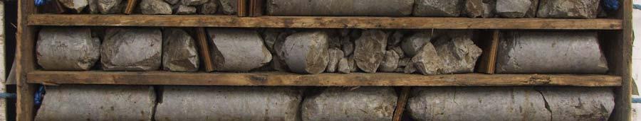
45 Rotary Core Photographic Record Number: RC01 Project Project No Engineer Medite, Clonmel RPS EPA Export :23:40:41
46 Coords: rilled y W Logged y E N orehole No RC02 Sheet 1 of 3 Hole Type Rotary Cored Client: Medite, Europe ates: 09/01/201410/01/2014 Level: m AO 1:50 Well / Water ackfillstrikes Samples & In Situ Testing epth (m) Type Casing / Level epth Flush (m AO) (m) Stratum escription See H02 for overburden details N=35 (9,7/10,8,8,9) N=30 (7,7/8,9,7,6) N=33 (12,6/6,10,7,10) Open hole boring. riller described: ense, sandy GRAVEL with boulder content. Open hole boring. riller described: Stiff CLAY with boulder content N=27 (6,8/8,6,7,6) N=21 (3,4/6,5,6,4) 9.00 Struck 3.00m 10.10m 14.90m 17.60m Remarks: Water epth (m) Type Casing Level epth Rose to After Equipment & Methods: Sealed Comment See shift data orehole terminated at required depth. 50mm dia standpipe installed, response zone from 20.2m to 2.0m. Soil Mech PSM 8G Compressed airmist flush. Hole Information: Hole epth Hole iameter Casing iameter 15.00m 16.00m 20.20m 131mm 76mm 131mm Shift ata: 131mm 76mm 131mm Groundwater 4.10m 2.60m 9.40m Continued next sheet Chiselling: epths (m) Time (hhmm) Tool to Shift (dd/mm/yyyy) Casing depth Remarks 09/01/ m Start of orehole 09/01/ m End of shift 10/01/ m Start of shift 10/01/ m End of orehole HoleASE III (ld ) Standard orehole Log v2 dated 27th Nov 03 EPA Export :23:40:41
47 Coords: E N rilled y W Logged y orehole No RC02 Sheet 2 of 3 Hole Type Rotary Cored Client: Medite, Europe ates: 09/01/201410/01/2014 Level: m AO 1:50 Well / Water ackfillstrikes Samples & In Situ Testing epth (m) Type Casing / Level epth Flush (m AO) (m) Stratum escription Open hole boring. riller described: Stiff CLAY with boulder content N=26 (7,6/8,7,5,6) N=37 (8,10/10,9,10,8) N=69 (11,18/15,12,21,21) N=22 (4,5/6,6,5,5) % No recovery Open hole boring. riller described: Stiff CLAY with boulder content N=21 (7,6/5,6,6,4) N=12 (4,2/3,3,4,2) Open hole boring. riller described: Sandy CLAY. Struck 3.00m 10.10m 14.90m 17.60m Remarks: Water epth (m) TCR SCR RQ Fracture spacing Casing Level epth Rose to After Sealed Comment See shift data orehole terminated at required depth. 50mm dia standpipe installed, response zone from 20.2m to 2.0m. Equipment & Methods: Soil Mech PSM 8G Compressed airmist flush. Hole Information: Hole epth Hole iameter Casing iameter 15.00m 16.00m 20.20m 131mm 76mm 131mm Shift ata: 131mm 76mm 131mm Groundwater 4.10m 2.60m 9.40m Continued next sheet Chiselling: epths (m) Time (hhmm) Tool to Shift (dd/mm/yyyy) Casing depth Remarks 09/01/ m Start of orehole 09/01/ m End of shift 10/01/ m Start of shift 10/01/ m End of orehole HoleASE III (ld ) Standard orehole Log v2 dated 27th Nov 03 EPA Export :23:40:41
48 Coords: E N rilled y W Logged y orehole No RC02 Sheet 3 of 3 Hole Type Rotary Cored Client: Medite, Europe ates: 09/01/201410/01/2014 Level: m AO 1:50 Well / Water ackfillstrikes epth (m) Rotary Coring TCR SCR RQ Casing / Level epth Flush (m AO) (m) Stratum escription Open hole boring. riller described: Sandy CLAY N=19 (8,4/4,6,5,4) Open hole boring. riller described: Stiff, sandy CLAY with boulder content End of orehole at m Struck 3.00m 10.10m 14.90m 17.60m Remarks: Water epth (m) TCR SCR RQ Fracture spacing Casing Level epth Rose to After Equipment & Methods: Sealed Comment See shift data orehole terminated at required depth. 50mm dia standpipe installed, response zone from 20.2m to 2.0m. Soil Mech PSM 8G Compressed airmist flush. Hole Information: Hole epth Hole iameter Casing iameter 15.00m 16.00m 20.20m 131mm 76mm 131mm Shift ata: 131mm 76mm 131mm Groundwater 4.10m 2.60m 9.40m Chiselling: epths (m) Time (hhmm) Tool to Shift (dd/mm/yyyy) Casing depth Remarks 09/01/ m Start of orehole 09/01/ m End of shift 10/01/ m Start of shift 10/01/ m End of orehole HoleASE III (ld ) Standard orehole Log v2 dated 27th Nov 03 EPA Export :23:40:41
49 Coords: rilled y W Logged y JMS E N orehole No RC03 Sheet 1 of 2 Hole Type Rotary Cored Client: Medite, Europe ates: 20/01/201424/01/2014 Level: m AO 1:50 Well / Water ackfillstrikes Samples & In Situ Testing epth (m) Type Casing / Level epth Flush (m AO) (m) Stratum escription See H03 for overburden details Struck Rose to After Sealed Comment 14.00m See shift data Remarks: Water epth (m) Type Casing Level epth orehole terminated at required depth. Equipment & Methods: Soil Mech PSM 8G Compressed airmist flush. Hole Information: Hole epth Hole iameter Casing iameter 14.50m 17.50m 131mm 76mm Shift ata: 131mm 76mm Groundwater 8.20m 7.80m 8.10m Continued next sheet Chiselling: epths (m) Time (hhmm) Tool to Shift (dd/mm/yyyy) Casing depth Remarks 20/01/ m Start of orehole 20/01/ m End of shift 24/01/ m Start of shift 24/01/ m End of orehole HoleASE III (ld ) Standard orehole Log v2 dated 27th Nov 03 EPA Export :23:40:41
50 Coords: rilled y W Logged y JMS E N orehole No RC03 Sheet 2 of 2 Hole Type Rotary Cored Client: Medite, Europe ates: 20/01/201424/01/2014 Level: m AO 1:50 Well / Water ackfillstrikes Samples & In Situ Testing epth (m) Type Casing / Level epth Flush (m AO) (m) Stratum escription See H03 for overburden details (50 for 2mm) mm min 100mm avg 210mm max % Open hole boring. riller described: Rock. Strong, grey, fossiliferous LIMESTONE with calcite veining. Fractures: Weathering: Slightly weathered. Loss of strength. Clay smearing. Localised discolouration. Fractures: Closely to medium spaced. Fractures dip approximately 6590 degrees with planar and undulating surfaces. 14.5m 15.0m: Fracture index m 15.5m: Fracture index m 16.3m: Fracture index m 17.5m: Fracture index m 16.85m: Nonintact End of orehole at m Struck Rose to After Sealed Comment 14.00m See shift data Remarks: Water epth (m) TCR SCR RQ Fracture spacing Casing Level epth orehole terminated at required depth. Equipment & Methods: Soil Mech PSM 8G Compressed airmist flush. Hole Information: Hole epth Hole iameter Casing iameter 14.50m 17.50m 131mm 76mm Shift ata: 131mm 76mm Groundwater 8.20m 7.80m 8.10m Chiselling: epths (m) Time (hhmm) Tool to Shift (dd/mm/yyyy) Casing depth Remarks 20/01/ m Start of orehole 20/01/ m End of shift 24/01/ m Start of shift 24/01/ m End of orehole HoleASE III (ld ) Standard orehole Log v2 dated 27th Nov 03 EPA Export :23:40:41


51 Rotary Core Photographic Record Number: RC03 Project Project No Engineer Medite, Clonmel RPS EPA Export :23:40:41
52 Coords: rilled y W Logged y JMS E N orehole No RC04 Sheet 1 of 2 Hole Type Rotary Cored Client: Medite, Europe ates: 15/01/201416/01/2014 Level: m AO 1:50 Well / Water ackfillstrikes Samples & In Situ Testing epth (m) Type Casing / Level epth Flush (m AO) (m) Stratum escription See H04 for overburden details (50 for 6mm) (25,25 for 2mm/25 for 3mm) % Open hole boring. riller described: Possible rock recovered as: Light brown/ grey, slightly sandy GRAVEL. Sand is fine to medium. Gravel is coarse, subangular to rounded, Siltstone N=68 (10,14/12,18,17,21) 0 25 (22,25 for 2mm/25 for 2mm) % Open hole boring. riller described: Weathered rock. Strong, light grey, fossiliferous, cherty LIMESTONE with calcite veining. Weathering: Slightly weathered. Localised discolouration. Minor orange oxide staining. Fractures: Closely to medium spaced. Fractures dip: 1) Approximately 90 degrees 2) Approximately 10 degrees. Surfaces are planar and undulating rough. 6.0m 7.2m: Fracture index m 8.3m: Fracture index mm min 100mm avg 480mm max 8.3m 9.3m: Fracture index 5. Struck Rose to After Sealed Comment 4.30m Remarks: Water epth (m) TCR SCR RQ Fracture spacing Casing Level epth orehole terminated at required depth. 50mm dia standpipe installed, response zone from 10.0m to 4.0m. Equipment & Methods: Soil Mech PSM 8G Compressed airmist flush. Hole Information: Hole epth Hole iameter Casing iameter 2.50m 4.50m 6.00m 16.50m 131mm 76mm 131mm 76mm Shift ata: 131mm 76mm 131mm 76mm Groundwater 5.90m Continued next sheet Chiselling: epths (m) Time (hhmm) Tool to Shift (dd/mm/yyyy) Casing depth Remarks 15/01/ m Start of orehole 15/01/ m End of shift 16/01/ m Start of shift 16/01/ m End of orehole HoleASE III (ld ) Standard orehole Log v2 dated 27th Nov 03 EPA Export :23:40:41
53 Coords: E N rilled y W Logged y JMS orehole No RC04 Sheet 2 of 2 Hole Type Rotary Cored Client: Medite, Europe ates: 15/01/201416/01/2014 Level: m AO 1:50 Well / Water ackfillstrikes epth (m) Rotary Coring TCR SCR RQ Fractures Casing / Level epth Flush (m AO) (m) Stratum escription Strong, light grey, fossiliferous, cherty LIMESTONE with calcite veining. Weathering: Slightly weathered. Localised discolouration. Minor orange oxide staining. Fractures: Closely to medium spaced. Fractures dip: 1) Approximately 90 degrees 2) Approximately 10 degrees. Surfaces are planar and undulating rough. 9.3m 10.8m: Fracture index m 12.1m: Fracture index mm min 90mm avg 130mm max 12.1m 12.7m: Fracture index mm min 150mm avg 430mm max 12.7m 14.3m: Fracture index m 15.1m: Fracture index m 16.5m: Fracture index End of orehole at m 17 Struck Rose to After Sealed Comment 4.30m Remarks: Water epth (m) TCR SCR RQ Fracture spacing Casing Level epth orehole terminated at required depth. 50mm dia standpipe installed, response zone from 10.0m to 4.0m. Equipment & Methods: Soil Mech PSM 8G Compressed airmist flush. Hole Information: Hole epth Hole iameter Casing iameter 2.50m 4.50m 6.00m 16.50m 131mm 76mm 131mm 76mm Shift ata: 131mm 76mm 131mm 76mm Chiselling: epths (m) Time (hhmm) Tool to Groundwater Shift (dd/mm/yyyy) Casing depth Remarks 15/01/ m Start of orehole 5.90m 15/01/ m End of shift 16/01/ m Start of shift 16/01/ m End of orehole HoleASE III (ld ) Standard orehole Log v2 dated 27th Nov 03 EPA Export :23:40:42


54 Rotary Core Photographic Record Number: RC04 Project Project No Engineer Medite, Clonmel RPS EPA Export :23:40:42


55 Rotary Core Photographic Record Number: RC04 Project Project No Engineer Medite, Clonmel RPS EPA Export :23:40:42
56 Coords: E N rilled y W Logged y orehole No RC05 Sheet 1 of 2 Hole Type RO Client: Medite, Europe ates: 24/01/201404/02/2014 Level: m AO 1:50 Well / Water ackfillstrikes Samples & In Situ Testing epth (m) Type 0.00 N=23 (4,5/6,5,7,5) Casing / Level epth Flush (m AO) (m) 0.00 Stratum escription Open hole boring. riller described: CLAY with cobble content N=25 (6,6/5,7,8,5) Open hole boring. riller described: Stiff CLAY with cobble content and boulder content N=25 (3,2/5,7,7,6) N=16 (5,4/4,4,3,5) N=24 (8,7/8,5,5,6) Open hole boring. riller described: Stiff CLAY with boulder content N=22 (4,5/7,6,4,5) Open hole boring. riller described: Stiff, gravelly CLAY N=22 (6,8/7,5,4,6) 9.00 Struck 9.20m 12.10m Remarks: Water epth (m) Type Casing Level epth Rose to After Equipment & Methods: Sealed orehole terminated at required depth. Soil Mech PSM 8G Hole Information: Hole epth Hole iameter Casing iameter Comment See shift data 14.00m 131mm 131mm Shift ata: Groundwater 12.40m Continued next sheet Chiselling: epths (m) Time (hhmm) Tool to Shift (dd/mm/yyyy) Casing depth Remarks 24/01/ m Start of orehole 24/01/ m End of shift 04/02/ m Start of shift 04/02/ m End of orehole HoleASE III (ld ) Standard orehole Log v2 dated 27th Nov 03 EPA Export :23:40:42
57 Coords: E N rilled y W Logged y orehole No RC05 Sheet 2 of 2 Hole Type RO Client: Medite, Europe ates: 24/01/201404/02/2014 Level: m AO 1:50 Well / Water ackfillstrikes Samples & In Situ Testing epth (m) Type Casing / Level epth Flush (m AO) (m) Stratum escription Open hole boring. riller described: Stiff, gravelly CLAY N=21 (8,11/5,5,6,5) Open hole boring. riller described: Stiff CLAY with boulder content N=37 (6,8/10,11,9,7) N=43 (12,10/14,10,7,12) End of orehole at m Struck 9.20m 12.10m Remarks: Water epth (m) Type Casing Level epth Rose to After Equipment & Methods: Sealed orehole terminated at required depth. Soil Mech PSM 8G Hole Information: Hole epth Hole iameter Casing iameter Comment See shift data 14.00m 131mm 131mm Shift ata: Groundwater 12.40m Chiselling: epths (m) Time (hhmm) Tool to Shift (dd/mm/yyyy) Casing depth Remarks 24/01/ m Start of orehole 24/01/ m End of shift 04/02/ m Start of shift 04/02/ m End of orehole HoleASE III (ld ) Standard orehole Log v2 dated 27th Nov 03 EPA Export :23:40:42
58 Coords: E N rilled y W Logged y JMS orehole No RC06 Sheet 1 of 3 Hole Type Rotary Cored Client: Medite, Europe ates: 06/02/201407/02/2014 Level: m AO 1:50 Well / Water ackfillstrikes Samples & In Situ Testing epth (m) Type 0.00 N=27 (7,6/5,5,8,9) Casing / Level epth Flush (m AO) (m) 0.00 Stratum escription Open hole boring. riller described: COLES and OULERS N=39 (3,6/5,10,11,13) Open hole boring. riller described: ense, sandy GRAVEL with cobble content (6,12/25 for 3mm) Open hole boring. riller described: Sandy GRAVEL with boulder content N=35 (8,6/7,6,10,12) 8 0 N=27 (13,7/7,6,5,9) % ark grey OULER. Open hole boring. riller described: Stiff, sandy gravelly CLAY with boulder content. Open hole boring. riller described: Stiff, sandy gravelly CLAY N=26 (8,4/5,7,4,10) Open hole boring. riller described: Stiff, sandy gravelly CLAY with boulder content N=30 (16,10/10,8,7,5) Struck 4.70m 14.70m Remarks: Water epth (m) TCR SCR RQ Fracture spacing Casing Level epth Rose to After Equipment & Methods: Hole Information: Sealed Comment Hole epth Hole iameter Casing iameter See shift data 4.50m 131mm 131mm 5.50m 76mm 76mm 15.00m 131mm 131mm 20.00m 76mm 76mm orehole terminated due to obstruction. Soil Mech PSM 8G Compressed airmist flush. Shift ata: Groundwater 6.20m 5.60m 11.20m Continued next sheet Chiselling: epths (m) Time (hhmm) Tool to Shift (dd/mm/yyyy) Casing depth Remarks 06/02/ m Start of orehole 06/02/ m End of shift 07/02/ m Start of shift 07/02/ m End of orehole HoleASE III (ld ) Standard orehole Log v2 dated 27th Nov 03 EPA Export :23:40:42
59 Coords: E N rilled y W Logged y JMS orehole No RC06 Sheet 2 of 3 Hole Type Rotary Cored Client: Medite, Europe ates: 06/02/201407/02/2014 Level: m AO 1:50 Well / Water ackfillstrikes epth (m) Rotary Coring TCR SCR RQ Fractures Casing / Level epth Flush (m AO) (m) Stratum escription Open hole boring. riller described: CLAY with boulder content N=28 (7,6/10,7,5,6) Open hole boring. riller described: Stiff, sandy CLAY with boulder content N=35 (12,7/11,6,8,10) Open hole boring. riller described: ense, clayey SAN with boulder content (50 for 6mm) % Open hole boring. riller described: oulder CLAY. Open hole boring. riller described: Possible rock. Possible weathered rock recovered as: GRAVEL with high cobble content. Gravel is coarse, subangular, limestone. Cobbles are subangular, limestone. 15.0m 16.0m: Fracture index m 17.2m: Fracture index m 18.5m: Fracture index mm min 50mm avg 10mm max Struck 4.70m 14.70m Remarks: Water epth (m) TCR SCR RQ Fracture spacing Casing Level epth Rose to Equipment & Methods: Hole Information: After Sealed Comment Hole epth Hole iameter Casing iameter See shift data 4.50m 131mm 131mm 5.50m 76mm 76mm 15.00m 131mm 131mm 20.00m 76mm 76mm orehole terminated due to obstruction. Soil Mech PSM 8G Compressed airmist flush. Shift ata: Groundwater 6.20m 5.60m 11.20m Continued next sheet Chiselling: epths (m) Time (hhmm) Tool to Shift (dd/mm/yyyy) Casing depth Remarks 06/02/ m Start of orehole 06/02/ m End of shift 07/02/ m Start of shift 07/02/ m End of orehole HoleASE III (ld ) Standard orehole Log v2 dated 27th Nov 03 EPA Export :23:40:42
60 Coords: E N rilled y W Logged y JMS orehole No RC06 Sheet 3 of 3 Hole Type Rotary Cored Client: Medite, Europe ates: 06/02/201407/02/2014 Level: m AO 1:50 Well / Water Rotary Coring ackfillstrikes epth (m) TCR SCR RQ Fractures Casing / Level epth Flush (m AO) (m) Stratum escription Possible weathered rock recovered as: GRAVEL with high cobble content. Gravel is coarse, subangular, limestone. Cobbles are subangular, limestone. 18.5m 20.0m: Fracture index End of orehole at m Struck 4.70m 14.70m Remarks: Water epth (m) TCR SCR RQ Fracture spacing Casing Level epth Rose to Equipment & Methods: Hole Information: After Sealed Comment Hole epth Hole iameter Casing iameter See shift data 4.50m 131mm 131mm 5.50m 76mm 76mm 15.00m 131mm 131mm 20.00m 76mm 76mm orehole terminated due to obstruction. Soil Mech PSM 8G Compressed airmist flush. Shift ata: Groundwater 6.20m 5.60m 11.20m Chiselling: epths (m) Time (hhmm) Tool to Shift (dd/mm/yyyy) Casing depth Remarks 06/02/ m Start of orehole 06/02/ m End of shift 07/02/ m Start of shift 07/02/ m End of orehole HoleASE III (ld ) Standard orehole Log v2 dated 27th Nov 03 EPA Export :23:40:42


61 Rotary Core Photographic Record Number: RC06 Project Project No Engineer Medite, Clonmel RPS EPA Export :23:40:42
B-1 BORE LOCATION PLAN. EXHIBIT Drawn By: 115G BROOKS VETERINARY CLINIC CITY BASE LANDING AND GOLIAD ROAD SAN ANTONIO, TEXAS.
 N B-1 SYMBOLS: Exploratory Boring Location Project Mngr: BORE LOCATION PLAN Project No. GK EXHIBIT Drawn By: 115G1063.02 GK Scale: Checked By: 1045 Central Parkway North, Suite 103 San Antonio, Texas 78232
Chapter 12 Subsurface Exploration
 Page 12 1 Chapter 12 Subsurface Exploration 1. The process of identifying the layers of deposits that underlie a proposed structure and their physical characteristics is generally referred to as (a) subsurface
Appendix F Laboratory test results
 Appendix F Laboratory test results SOIL AND ROCK SAMPLE ANALYSIS LABORATORY TEST REPORT To: Bord Gais Copy: Orla Smyth (kkidd@bge.ie) From: Stephen Watson Laboratory Manager Causeway Geotech Ltd Tel: +44(0)2827666640
Eastwood & Partners St. Andrew's House 23 Kingfield Road Sheffield S11 9AS. Co-ords: Level: Dimensions: Depth 1.50m
 epth (m) 0.0 Kingfield Road S AS Coords: imensions: epth.0m epth Level (m) (m AO) Stratum escription 0.0m.0m TOPSOIL: Brown sandy gravelly with rootlets. Gravel is angular to subrounded fine to coarse
APPENDIX A. Borehole Logs Explanation of Terms and Symbols
 APPENDIX A Borehole Logs Explanation of Terms and Symbols Page 153 of 168 EXPLANATION OF TERMS AND SYMBOLS The terms and symbols used on the borehole logs to summarize the results of field investigation
DRILL HOLE # BH-BGC13-FN-01
 DILL HOLE # BH-BGC3-FN-0 Drill Method: Mud otary/coring Depth To ock (m): N/A Page of 7 eviewed by: AJB 0 GAVEL (GW) Fine to coarse, sandy, well graded, dense, max particle size = 30 mm, angular to subrounded,
16 January 2018 Job Number: RICHARD NEWMAN C\- CLARK FORTUNE MCDONALD AND ASSOCIATES PO BOX 553 QUEENSTOWN
 16 January 2018 Job Number: 50595 RICHARD NEWMAN C\- CLARK FORTUNE MCDONALD AND ASSOCIATES PO BOX 553 QUEENSTOWN CHANSEN@CFMA.CO.NZ STORMWATER DISPOSAL ASSESSMENT Dear Richard, RDAgritech were requested
Boreholes. Implementation. Boring. Boreholes may be excavated by one of these methods: 1. Auger Boring 2. Wash Boring 3.
 Implementation Boreholes 1. Auger Boring 2. Wash Boring 3. Rotary Drilling Boring Boreholes may be excavated by one of these methods: 4. Percussion Drilling The right choice of method depends on: Ground
patersongroup Design for Earthquakes Consulting Engineers May 19, 2016 File: PG3733-LET.01
 patersongroup May 19, 2016 File: PG3733-LET.01 Hydro Ottawa Limited c/o Cresa Toronto 170 University Avenue, Suite 1 Toronto, Ontario M5H 3B3 Attention: Ms. Barbara Wright Consulting Engineers 154 Colonnade
Depth (ft) USCS Soil Description TOPSOIL & FOREST DUFF
 USCS Soil Description TOPSOIL & FOREST DUFF") Test Pit No. TP-6 Location: Latitude 47.543003, Longitude -121.980441 Approximate Ground Surface Elevation: 1,132 feet Depth (ft) USCS Soil Description 0 1.5 1.5 5.0 SM 5.0 8.0 SM Loose to medium dense,
Test Pit No. TP-6 Location: Latitude 47.543003, Longitude -121.980441 Approximate Ground Surface Elevation: 1,132 feet Depth (ft) USCS Soil Description 0 1.5 1.5 5.0 SM 5.0 8.0 SM Loose to medium dense,
Hydro One (Sept 2014) Hydro One (Sept 2014) Hydro One (Sept 2014)
 Hydro One (Sept 2014) Hydro One (Sept 2014)") TABLE 1 WELL CONSTRUCTION DETAILS MOE WWR No Well ID Location Installation Date Status Easting Coordinates Northing Source Elevation Screened Interval Screened Material Borehole Well Stick-up Ground Top
TABLE 1 WELL CONSTRUCTION DETAILS MOE WWR No Well ID Location Installation Date Status Easting Coordinates Northing Source Elevation Screened Interval Screened Material Borehole Well Stick-up Ground Top
 Project: ITHACA-TOMPKINS REGIONAL AIRPORT EXPANSION Project Location: ITHACA, NY Project Number: 218-34 Key to Soil Symbols and Terms TERMS DESCRIBING CONSISTENCY OR CONDITION COARSE-GRAINED SOILS (major
Gotechnical Investigations and Sampling
 Gotechnical Investigations and Sampling Amit Prashant Indian Institute of Technology Gandhinagar Short Course on Geotechnical Investigations for Structural Engineering 12 14 October, 2017 1 Purpose of
GEOTECHNICAL INVESTIGATION REPORT
 GEOTECHNICAL INVESTIGATION REPORT SOIL INVESTIGATION REPORT FOR STATIC TEST FACILITY FOR PROPELLANTS AT BDL, IBRAHIMPATNAM. Graphics Designers, M/s Architecture & Engineering 859, Banjara Avenue, Consultancy
BOREHOLE LOCATION PLAN
 BH2/Probe A BH1 Light cable percussion drilling rig Windowless Sampling Borehole and Dynamic Penetration Probing CLIENT: SITE: Date: Abingdon Hydro Ltd Abingdon Hydro Project, Nr Abingdon Wier August 2014
Superficial Geology Map - Slice A. Order Details: Order Number: Customer Reference: National Grid Reference: Slice: Site Area (Ha): Search Buffer (m):
: Search Buffer (m):") Superficial Geology Superficial Deposits are the youngest geological deposits formed during the most recent period of geological time, the Quaternary, which extends back about 1.8 million years from the
Superficial Geology Superficial Deposits are the youngest geological deposits formed during the most recent period of geological time, the Quaternary, which extends back about 1.8 million years from the
Natural Resources Wales. St Asaph FRMS (PAR) Ground Investigation Factual Report. January creative minds safe hands
 Ground Investigation Factual Report. January creative minds safe hands") Natural Resources Wales t Asaph FRM (PAR) Ground Investigation 01 Factual Report January 015 5 th Floor, Longcross Court, 7 Newport Road, Cardiff, CF 0A Tel 09 08 900 Email enviro.cardiff@wyg.com www.wyg.com
Natural Resources Wales t Asaph FRM (PAR) Ground Investigation 01 Factual Report January 015 5 th Floor, Longcross Court, 7 Newport Road, Cardiff, CF 0A Tel 09 08 900 Email enviro.cardiff@wyg.com www.wyg.com
 Photo 1 - Southerly view across 2700 parking lot toward existing building. Multi-residential building borders western side of property in upper right of view. Photo 2 - Southerly view across 2750 parking
A. V T = 1 B. Ms = 1 C. Vs = 1 D. Vv = 1
 Geology and Soil Mechanics 55401 /1A (2002-2003) Mark the best answer on the multiple choice answer sheet. 1. Soil mechanics is the application of hydraulics, geology and mechanics to problems relating
TRANSPORT SCOTLAND A9 DUALLING SOUTHERN SECTION NOTES ON EXPLORATORY HOLE RECORDS GENERAL NOTES. Contract No. G151043U Appendix A Rev KS/01
 1 OPERATING PROCEDURES GENERAL NOTES The procedure used for cable percussion boring, rotary drilling, trial pitting, sampling, in situ and laboratory testing and sample descriptions are generally in accordance
APPENDIX A GEOTECHNICAL REPORT
 The City of Winnipeg Bid Opportunity No. 529-2017 Template Version: C420170317 - RW APPENDIX A GEOTECHNICAL REPORT Quality Engineering Valued Relationships KGS Group 2017 Industrial Street Rehabilitation
Geology and Soil Mechanics /1A ( ) Mark the best answer on the multiple choice answer sheet.
 Mark the best answer on the multiple choice answer sheet.") Geology and Soil Mechanics 55401 /1A (2003-2004) Mark the best answer on the multiple choice answer sheet. 1. Soil mechanics is the application of hydraulics, geology and mechanics to problems relating
Geology and Soil Mechanics 55401 /1A (2003-2004) Mark the best answer on the multiple choice answer sheet. 1. Soil mechanics is the application of hydraulics, geology and mechanics to problems relating
Lake Rotoiti Wastewater Scheme - Stage 1 Investigations. Rotorua Lakes Council
 Lake Rotoiti Wastewater Scheme - Stage 1 Investigations Rotorua Lakes Council i Contents 1 Introduction...1 2 Site Description...1 3 Geological Setting...1 4 Geotechnical Investigation...1 4.1 Borehole
ENCE 3610 Soil Mechanics. Site Exploration and Characterisation Field Exploration Methods
 ENCE 3610 Soil Mechanics Site Exploration and Characterisation Field Exploration Methods Geotechnical Involvement in Project Phases Planning Design Alternatives Preparation of Detailed Plans Final Design
SCOPE OF INVESTIGATION Simple visual examination of soil at the surface or from shallow test pits. Detailed study of soil and groundwater to a
 Lecture-5 Soil Exploration Dr. Attaullah Shah 1 Today s Lecture Purpose of Soil Exploration Different methods 1. Test trenches and Pits 2. Auger and Wash Boring 3. Rotary Drilling 4. Geophysical Methods
Appendix A. Producer Statement Advisory Note
 Appendix A Producer Statement Advisory Note Ref. No. 17095 26 May 2017 PRODUCER STATEMENT CONSTRUCTION REVIEW (PS4) IMPORTANT ADVISORY NOTE The Building Consent Authority (BCA) frequently requires Producer
General. DATE December 10, 2013 PROJECT No TO Mary Jarvis Urbandale/Riverside South Development Corporation
 DATE December 10, 201 PROJECT No. 10-1121-0260- TO Mary Jarvis Urbandale/Riverside South Development Corporation CC Justin Robitaille, Urbandale Jonathan Párraga, J.L. Richards & Associates Limited FROM
Civil Engineering, Surveying and Environmental Consulting WASP0059.ltr.JLS.Mich Ave Bridge Geotech.docx
 2365 Haggerty Road South * Canton, Michigan 48188 P: 734-397-3100 * F: 734-397-3131 * www.manniksmithgroup.com August 29, 2012 Mr. Richard Kent Washtenaw County Parks and Recreation Commission 2330 Platt
Appendix J. Geological Investigation
 Appendix J Geological Investigation Appendix J Geological Environment Table of Contents Page 1 INTRODUCTION...J-1 1.1 Purpose of the Investigation...J-1 1.2 Scope of the Investigation...J-1 2 METHODO OF
ATTACHMENT A PRELIMINARY GEOTECHNICAL SUMMARY
 ATTACHMENT A PRELIMINARY GEOTECHNICAL SUMMARY Kevin M. Martin, P.E. KMM Geotechnical Consultants, LLC 7 Marshall Road Hampstead, NH 0384 603-489-6 (p)/ 603-489-8 (f)/78-78-4084(m) kevinmartinpe@aol.com
REPORT. Housing Re-Zone. Middle Road and Iona Road - Geotechnical Investigation Report
 REPORT Housing Re-Zone Middle Road and Iona Road - Geotechnical Investigation Report Prepared for Hastings istrict Council Prepared by Tonkin & Taylor Ltd ate April 06 Job Number 464.000 istribution: Hastings
Geotechnical Engineering Report
 Geotechnical Engineering Report Turner Turnpike Widening Bridge B Bridge Crossing: South 257 th West Avenue Creek County, Oklahoma June 1, 2016 Terracon Project No. 04155197 Prepared for: Garver, LLC Tulsa,
Geotechnical Data Report
 Geotechnical Data Report Downtown Greenville Future Conveyance Study December 1, 2015 Terracon Project No. 86155032 Prepared for: Prepared by: Terracon Consultants, Inc. December 1, 2015 561 Mauldin Road
10. GEOTECHNICAL EXPLORATION PROGRAM
 Geotechnical site investigations should be conducted in multiple phases to obtain data for use during the planning and design of the tunnel system. Geotechnical investigations typically are performed in
Geotechnical Engineering Report
 Geotechnical Engineering Report Turner Turnpike Widening Bridge D Bridge Crossing: South 209 th West Avenue Creek County, Oklahoma June 1, 2016 Terracon Project No. 04155197 Prepared for: Garver, LLC Tulsa,
Geotechnical Investigation
 Geotechnical Investigation Slope Stability Analysis for the Existing Slope Southwest of the Proposed Condo Developments 50 Ann Street, Bolton, Ontario Prepared For: Brookfield Homes (Ontario) Limited GeoPro
Appendix G GEOLOGICAL INVESTIGATION
 Appendix G GEOLOGICAL INVESTIGATION JOB NUMBER: 3268.001 DATE: 10-14-13 BY: CC SITE 0 2000 1"=2000' VICINITY MAP CARGILL PARCEL HICKORY STREET AND ENTERPRISE DRIVE NEWARK, CALIFORNIA FOR
Week 3 : (3HL) Coverage : Typical geotechnical problems and usual application of SI methods
 Coverage : Typical geotechnical problems and usual application of SI methods") LEARNING OUTCOMES Week 3 : (3HL) Coverage : Typical geotechnical problems and usual application of SI methods Learning Outcomes : At the end of this lecture/week, the students will be able to : 1. Discuss
LEARNING OUTCOMES Week 3 : (3HL) Coverage : Typical geotechnical problems and usual application of SI methods Learning Outcomes : At the end of this lecture/week, the students will be able to : 1. Discuss
APPENDIX C. Borehole Data
 APPENDIX C Borehole Data MAJOR DIVISIONS SOIL CLASSIFICATION CHART SYMBOLS GRAPH LETTER TYPICAL DESCRIPTIONS ADDITIONAL MATERIAL
SITE INVESTIGATION 1
 SITE INVESTIGATION 1 Definition The process of determining the layers of natural soil deposits that will underlie a proposed structure and their physical properties is generally referred to as site investigation.
Preliminary Geotechnical Investigation Cadiz / Trigg County I-24 Business Park. Cadiz, Kentucky
 Environmental & Geoscience, LLC 834 Madisonville Road Hopkinsville, KY 440 70.44.000 FAX 70.44.8300 www.wedrill.com A member of Trinity Energy & Infrastructure Group, LLC Preliminary Geotechnical Investigation
Field Exploration. March 31, J-U-B ENGINEERS, Inc. 115 Northstar Avenue Twin Falls, Idaho Attn: Mr. Tracy Ahrens, P. E. E:
 March 31, 201 11 Northstar Avenue 83301 Attn: Mr. Tracy Ahrens, P. E. E: taa@jub.com Re: Geotechnical Data Report Preliminary Phase 1 Field Exploration Revision No. 1 Proposed Rapid Infiltration Basin
CONTENTS. 1. GeneralsG Field Investigation WorkG Laboratory Testing Work Surface Soil Description-- 7.
 CONTENTS Page 1. GeneralsG 4 2. Field Investigation WorkG 4 3. Laboratory Testing Work--- 5 4. Surface Soil Description-- 7 Appendix A Borehole Location Plan 11 Soil Profile-- 15 Bore Logs--=---- 18 Appendix
Manor Farm, Otley Road, Adel - preliminary findings
 005/87/ 6 th September 07 Mr G Titchmarsh Titchmarsh & Bagley. Prospect House Sovereign Street Leeds LS BJ Registered in England 07068066 Parkhill Wetherby West Yorkshire LS 5DZ T 097 55 0 www.lithos.co.uk
ADDENDUM 1 FISHER SLOUGH RESTORATION PROJECT SKAGIT COUNTY, WASHINGTON
 F I N A L A D D E N D U M 1 R E P O R T ADDENDUM 1 FISHER SLOUGH RESTORATION PROJECT SKAGIT COUNTY, WASHINGTON REPORT OF GEOTECHNICAL INVESTIGATION URS JOB NO. 3376186 Prepared for Tetra Tech Inc. 142
Appendix F Geotechnical Investigation
 Appendix F Geotechnical Investigation Cie Sucriere de Bel Ombre Ltee Residential Development at Bel Ombre Environmental Impact Assessment F1 Geotechnical Investigation This appendix includes the Factual
The process of determining the layers of natural soil deposits that will underlie a proposed structure and their physical properties is generally
 The process of determining the layers of natural soil deposits that will underlie a proposed structure and their physical properties is generally referred to as sub surface investigation 2 1 For proper
SUMMARY REPORT ON GROUND INVESTIGATIONS AT WALSHESTOWN PIT CO. KILDARE. Submitted to:
 Golder Associates Ireland Town Centre House, Dublin Road, Naas, Co. Kildare, Ireland Tel: [353] (0)45 874411 Fax: [353] (0)45 874549 E-mail: info@golder.ie http://www.golder.com SUMMARY REPORT ON GROUND
GEOTECHNICAL ENGINEERING II. Subject Code : 06CV64 Internal Assessment Marks : 25 PART A UNIT 1
 GEOTECHNICAL ENGINEERING II Subject Code : 06CV64 Internal Assessment Marks : 25 PART A UNIT 1 1. SUBSURFACE EXPLORATION 1.1 Importance, Exploration Program 1.2 Methods of exploration, Boring, Sounding
LEGEND BUSINESS ZONE NORTH OF AGRESEARCH BOREHOLE CPT SEISMIC CPT AUGER SCALE. Powells Road TEST PIT AGRESEARCH INNOVATION PARK. Hamilton Ring Road
 LEGEND ra R aku Ru BUSINESS ZONE NORTH OF Powells Road oad AGRESEARCH BOREHOLE CPT SEISMIC CPT AUGER SCALE 3 mm TEST PIT AS121 SCPT12 TP18 BH13 TP15 2 AS125 AS126 TP14 BH12 AGRESEARCH CPT13 TP17 INNOVATION
Geotechnical Engineering Report
 Geotechnical Engineering Report Turner Turnpike Widening Polecat Creek Bridge (Bridge A) June 1, 2016 Terracon Project No. 04155197 Prepared for: Garver, LLC Prepared by: Terracon Consultants, Inc. TABLE
GEOTECHNICAL REPORT. Matanuska-Susitna Borough. Parks Highway Connections Museum Drive. Matanuska-Susitna Borough, Alaska.
 Matanuska-Susitna Borough GEOTECHNICAL REPORT Parks Highway Connections Museum Drive Matanuska-Susitna Borough, Alaska March 2, 20 Prepared By: John Thornley, PE Geotechnical Engineer 333 Arctic Blvd.,
REPORT NO 12/115/D NOVEMBER 2012 GEOTECHNICAL INVESTIGATION FOR THE PROPOSED SOLAR PHOTOVOLTAIC FACILITY, GROOTVLEI POWER STATION
 Consulting Geotechnical Engineers & Engineering Geologists P.O.Box 3557 Cramerview 2060. Tel: (011) 465-1699. Fax: (011) 465-4586. Cell 082 556 7302 & 076 966 8445 REPORT NO 12/115/D NOVEMBER 2012 GEOTECHNICAL
REPORT ON SLOPE STABILITY INVESTIGATION DON MILLS ROAD AND EGLINTON AVENUE EAST TORONTO, ONTARIO. Prepared for:
 REPORT ON SLOPE STABILITY INVESTIGATION DON MILLS ROAD AND EGLINTON AVENUE EAST TORONTO, ONTARIO Prepared for: TORONTO AND REGION CONSERVATION AUTHORITY Prepared By: SIRATI & PARTNERS CONSULTANTS LIMITED
Introduction to Soil Mechanics Geotechnical Engineering-II
 Introduction to Soil Mechanics Geotechnical Engineering-II ground SIVA Dr. Attaullah Shah 1 Soil Formation Soil derives from Latin word Solum having same meanings as our modern world. From Geologist point
NHBRA SOIL LABORATORY SECTION INTERIM REVISED TEST RATES FOR THE MATERIALS LABORATORY
 NHBRA SOIL LABORATORY SECTION INTERIM REVISED TEST RATES FOR THE MATERIALS LABORATORY DATE OF REVISION: ) 10th October 2010 S/N TEST DESCRIPTION UNIT RATE REMARKS 1 Sieve Analysis (wet and dry methods
APPENDIX C HYDROGEOLOGIC INVESTIGATION
 Figure B-5.7 Figure B-5.8 Preliminary Geotechnical and Environmental Report Appendix C Hydrogeologic Investigation APPENDIX C HYDROGEOLOGIC INVESTIGATION December 21, 2011 WESTSIDE SUBWAY EXTENSION PROJECT
patersongroup memorandum 1.0 Field Investigation consulting engineers
 consulting engineers memorandum to: KDSA Development Corporation - Ms. Susan Anglin - susananglin6@gmail.com re: Pavement Structure Recommendations - Shady Maple Road Proposed Braeburn Estates Residential
SI Planning & Laboratory Testing for Hill-Site Development
 SI Planning & Laboratory Testing for Hill-Site Development 21 April 2009 IEM Penang Ir. Tan Yean Chin G&P Geotechnics Sdn Bhd Cameron Highlands, 1961 Genting Highland Tower 1993 Bukit Antarabangsa, 1999
New WW Hastings Hospital Geotechnical Investigation RFP Addendum #1
 88 E. Marshall Street, Suite 0 Tulsa, OK 76 98 8 9 Phone 98 8 798 FAX DATE: April 9, 0 ADDENDUM NO.: PROJECT: New WW Hastings Hospital BID PACKAGE NO: Geotechnical Investigation RFP SUBMITTED BY: CNCR
 UNIT I SITE INVESTIGATION AND SELECTION OF FOUNDATION Types of boring 1.Displacement borings It is combined method of sampling & boring operation. Closed bottom sampler, slit cup, or piston type is forced
Safe bearing capacity evaluation of the bridge site along Syafrubesi-Rasuwagadhi road, Central Nepal
 Bulletin of the Department of Geology Bulletin of the Department of Geology, Tribhuvan University, Kathmandu, Nepal, Vol. 12, 2009, pp. 95 100 Safe bearing capacity evaluation of the bridge site along
THE INSTITUTE OF COST ACCOUNTANTS OF INDIA (ICAI)
") THE INSTITUTE OF COST ACCOUNTANTS OF INDIA (ICAI) GEOTECHNICAL INVESTIGATION REPORT FOR PROPOSED PROJECT INSTITUTIONAL BUILDING FOR ICAI AT CBD BELAPUR, NAVI MUMBAI OCTOBER 2012 1281-2012-073 BY THANE
THE INSTITUTE OF COST ACCOUNTANTS OF INDIA (ICAI) GEOTECHNICAL INVESTIGATION REPORT FOR PROPOSED PROJECT INSTITUTIONAL BUILDING FOR ICAI AT CBD BELAPUR, NAVI MUMBAI OCTOBER 2012 1281-2012-073 BY THANE
SLOPE STABILITY ASSESSMENT PROPOSED RESIDENTIAL SUBDIVISION 161 LAKESHORE ROAD EAST TOWN OF THE BLUE MOUNTAINS, ONTARIO
 SLOPE STABILITY ASSESSMENT PROPOSED RESIDENTIAL SUBDIVISION 161 LAKESHORE ROAD EAST TOWN OF THE BLUE MOUNTAINS, ONTARIO PETO MacCALLUM LTD. 19 CHURCHILL DRIVE BARRIE, ONTARIO L4N 8Z5 PHONE: (705) 734-3900
Manual on Subsurface Investigations National Highway Institute Publication No. FHWA NHI Federal Highway Administration Washington, DC
 Manual on Subsurface Investigations National Highway Institute Publication No. FHWA NHI-01-031 Federal Highway Administration Washington, DC Geotechnical Site Characterization July 2001 by Paul W. Mayne,
ENGINEERING ASSOCIATES
 July 16, 211 Vista Design, Inc. 11634 Worcester Highway Showell, Maryland 21862 Attention: Reference: Dear Mr. Polk: Mr. Richard F. Polk, P.E. Geotechnical Engineering Report Charles County RFP No. 11-9
DATA REPORT GEOTECHNICAL INVESTIGATION GALVESTON CRUISE TERMINAL 2 GALVESTON, TEXAS
 DATA REPORT GEOTECHNICAL INVESTIGATION GALVESTON CRUISE TERMINAL 2 GALVESTON, TEXAS SUBMITTED TO PORT OF GALVESTON 123 ROSENBERG AVENUE, 8TH FLOOR GALVESTON, TEXAS 77553 BY HVJ ASSOCIATES, INC. HOUSTON,
VOLUME III GEOLOGY, HYDROGEOLOGY & GEOTECHNICAL REPORT CAPITAL REGION RESOURCE RECOVERY CENTRE
 VOLUME III GEOLOGY, HYDROGEOLOGY & GEOTECHNICAL REPT CAPITAL REGION RESOURCE RECOVERY CENTRE APPENDIX A Borehole Records December Report No. //vol III LIST OF ABBREVIATIONS The abbreviations coonly employed
B-1 SURFACE ELEVATION
 5A 5B LOGGED BY El. S. Bhangoo DRILLING CONTRACTOR Pitcher Drilling DRILLING METHOD Rotary Wash BEGIN DATE 12-14-12 SAMPLER TYPE(S) AND SIZE(S) (ID) SPT, MC BOREHOLE BACKFILL AND COMPLETION COMPLETION
SOIL INVESTIGATION REPORT. PROPOSED HOUSING DEVELOPMENT PROJECT Coral Spring, Trelawny, Jamaica.
 SOIL INVESTIGATION REPORT PROPOSED HOUSING DEVELOPMENT PROJECT Coral Spring, Trelawny, Jamaica. Prepared for: FCS Consultants 7a Barbados Avenue Kingston 5, Jamaica Prepared by: NHL Engineering Limited
3.0 GEOLOGY AND HYDROGEOLOGY
 3.0 GEOLOGY AND HYDROGEOLOGY 3.1 Methodology The Geological Survey of Ireland (GSI) publication Geology of South Cork was consulted to establish the nature of the bedrock lithology and Quaternary sediments.
Geotechnical Data Report
 Geotechnical Data Report ReWa Solar Farm at Durbin Creek Fountain Inn, South Carolina September 1, 2017 Terracon Project No. 86165043 Prepared for: Renewable Water Resources Greenville, South Carolina
East Land Quality Forum Drilling Techniques; Old and New
 East Land Quality Forum Drilling Techniques; Old and New 1 Introduction Different Drilling Methods Rota-sonic drilling What is it and how does it work? Different types of Rota-Sonic/Sonic Drilling Rigs
Terraprobe Consulting Geotechnical & Environmental Engineering Construction Materials Inspection & Testing
 Terraprobe Consulting Geotechnical & Environmental Engineering Construction Materials Inspection & Testing GEOTECHNICAL INVESTIGATION BLOCKS TO PIER HAMILTON, ONTARIO PREPARED FOR: City of Hamilton Waterfront
Appendix H. Geotechnical Investigation Report. Krosno Creek Flood Reduction Project PROJECT FILE REPORT CITY OF PICKERING
 Krosno Creek Flood Reduction Project PROJECT FILE REPORT CITY OF PICKERING Appendix H Geotechnical Investigation Report TMIG THE MUNICIPAL INFRASTRUCTURE GROUP LTD Report on Geotechnical Investigation
REPORT. Earthquake Commission. Christchurch Earthquake Recovery Geotechnical Factual Report Bryndwr Appendix C: Borehole Logs
 REPORT Earthquake Commission Christchurch Earthquake Recovery Geotechnical Factual Report Bryndwr Appendix C: Borehole Logs REPORT Earthquake Commission Christchurch Earthquake Recovery Geotechnical Factual
FINAL REPORT, GEOTECHNICAL INVESTIGATION, NORTHWEST RIVER BRIDGE RECONSTRUCTION, TERRA NOVA NATIONAL PARK, NL. File No:
 FINAL REPORT, GEOTECHNICAL INVESTIGATION, NORTHWEST RIVER BRIDGE RECONSTRUCTION, TERRA NOVA NATIONAL PARK, NL File No: 6847 Prepared for: Harbourside Engineering Consultants 9 Waverly Road, Suite Dartmouth
GEOTECHNICAL INVESTIGATION REPORT INFRASTRUCTURE PVT LTD
 GEOTECHNICAL INVESTIGATION REPORT Client : TAEIN CONSTRUCTION & INFRASTRUCTURE PVT LTD Office address : Flat No.104, A -Wing,1st floor,gloria Park, Paranjape Scheme, Bavdhan Khurd, Chandni Chowk, Pune
IN SITU SPECIFIC GRAVITY VS GRAIN SIZE: A BETTER METHOD TO ESTIMATE NEW WORK DREDGING PRODUCTION
 IN SITU SPECIFIC GRAVITY VS GRAIN SIZE: A BETTER METHOD TO ESTIMATE NEW WORK DREDGING PRODUCTION Nancy Case O Bourke, PE 1, Gregory L. Hartman, PE 2 and Paul Fuglevand, PE 3 ABSTRACT In-situ specific gravity
Attachment 07. Borehole Logs & Cross-section. Bord na Mbna, Environmental Consultancy Services November 2005
 ......... Bord na Mbna Energy Limited Environmental mpact Statement Attachment 7 Borehole Logs & Crosssection Bord na Mbna, Environmental Consultancy Services November 25 EPA Export 257213:18:16:2 EPA
3.0 SUMMARY OF FINDINGS
 AECOM 500 W Jefferson St. Suite 1600 Louisville, KY 40202 www.aecom.com 502-569-2301 tel 502-569-2304 fax October 17, 2018 Big Rivers Electric Corporation Sebree Generating Station 9000 Highway 2096 Robards,
BP Connect Development Turangi Preliminary Geotechnical Assessment Report
 The Holmes Group BP Connect Development Turangi Preliminary Geotechnical Assessment Report The Holmes Group BP Connect Development Turangi Preliminary Geotechnical Assessment Report Prepared By Opus International
REPORT OF SUBSURFACE EXPLORATION
 REPORT OF SUBSURFACE EXPLORATION GRAND RIVER DAM AUTHORITY HULBERT 69 KV SWITCHING STATION S. 440 Road Hulbert, Cherokee County, Oklahoma ENERCON PROJECT NO. GRDA006 MARCH 7, 2012 PREPARED FOR: C/O ENERCON
Soil Mechanics Brief Review. Presented by: Gary L. Seider, P.E.
 Soil Mechanics Brief Review Presented by: Gary L. Seider, P.E. 1 BASIC ROCK TYPES Igneous Rock (e.g. granite, basalt) Rock formed in place by cooling from magma Generally very stiff/strong and often abrasive
Dunkerrin - Guilfoyles Well
 Water Framework Directive Groundwater Monitoring Programme Site Information Dunkerrin - Guilfoyles Well ImagePath1: Dunkerrin - Guilfoyles Well\IE_SH_G_19_005_a_Pump House_(800_x_600).jpg Dunkerrin/ Guilfoyles
APPENDIX F CORRELATION EQUATIONS. F 1 In-Situ Tests
 APPENDIX F 1 APPENDIX F CORRELATION EQUATIONS F 1 In-Situ Tests 1. SPT (1) Sand (Hatanaka and Uchida, 1996), = effective vertical stress = effective friction angle = atmosphere pressure (Shmertmann, 1975)
Module 1 : Site Exploration and Geotechnical Investigation
 Objectives In this section you will learn the following Displacement borings Wash boring Auger boring Rotary drilling Percussion drilling Continuous sampling Boring methods of exploration The boring methods
Geotech Solutions GEOTECHNICAL INVESTIGATION IRONBARK RIDGE - STAGE 2A, 3B & 5 MUSWELLBROOK. Prepared for McCloy Group.
 Φ Geotech Solutions Geotech Solutions Pty Ltd ABN: 18 125 808 620 P.O Box 4224, Edgeworth 2285 Unit 4/5 Arunga r, Beresfield 2322 [P] 0249 494300 [F] 0249 660485 [E] info@geotechsolutions.com.au GEOTECHNICAL
DATE: 5/17/2012. LOGGED BY: Geoff Richards. COMPANY: Tetra Tech EM, Inc. DRILL FOREMAN: Walter
 ATTACHMENT 2 Page 1 of 1 B1 0 1 2 FILL, Dry; brownish red; clayey silt and gravel; ~30% gravel size fragments of dark grey microcrystalline (aphanetic), extrusive, igneous, rock 3 B1-4a 1100 B1-4b-duplicate
CONQUEST ENGINEERING LTD.
 CONQUEST ENGINEERING LTD. Geotechnical and Materials Engineers Concrete Technology, Blasting Consultants Construction Quality Assurance / Quality Control 8 Bluewater Road, Bedford, NS BB J6 Phone (9)85-7
 TP-1 N61E 0 DARK BROWN SANDY SILT (ML) stiff, wet with roots (Disturbed Surficial Soil) DEPTH (FEET) 5 REDDISH BROWN SANDSTONE intensely fractured, weak to friable, deeply weathered, tight (Franciscan
Conventional Field Testing & Issues (SPT, CPT, DCPT, Geophysical methods)
") Conventional Field Testing & Issues (SPT, CPT, DCPT, Geophysical methods) Ajanta Sachan Assistant Professor Civil Engineering IIT Gandhinagar Conventional Field Testing 1 Field Test: In-situ shear strength
Conventional Field Testing & Issues (SPT, CPT, DCPT, Geophysical methods) Ajanta Sachan Assistant Professor Civil Engineering IIT Gandhinagar Conventional Field Testing 1 Field Test: In-situ shear strength
Geotechnical Geotechnical Assessment
 Site Investigation Site Investigation Pile Probing Pile Probing Geotechnical Logging Geotechnical and Sampling Logging and Sampling Streetworks and Utilities Streetworks Avoidance and Utilities Avoidance
Report of Preliminary Geotechnical Exploration. CSO-012 Sewer Separation Cincinnati, Hamilton County, Ohio. February, 2011
 11242843_GeoTech_Preliminary - Feburary 2011_1/40 Report of Preliminary Geotechnical Exploration CSO-012 Sewer Separation Cincinnati, Hamilton County, Ohio February, 2011 11242843_GeoTech_Preliminary -
CITY OF VALDEZ Project Title: East Pioneer Reconstruction Project No.: Contract No.: TO: All Recipients Date: April 14, 2014
 CITY OF VALDEZ Project Title: East Pioneer Reconstruction Project No.: 13-3-1.32 Contract No.: 11 TO: All Recipients Date: April 14, 214 SUBJECT: Addendum No.1 This seventeen (17) page Addendum forms a
UNDP HARARE HOSPITAL PROPOSED NATPHARM WAREHOUSE
 UNDP HARARE HOSPITAL PROPOSED NATPHARM WAREHOUSE January 17 2016 TO CARRY OUT IN-SITU SOIL SURVEY, LABORATORY TESTS AND GEOTECHNICAL REPORTING. GEOTECHNICAL INVESTIGATIONS REPORT 1 2 Re: GEOTECHNICAL INVESTIGATIONS
College Road Breach Investigation - Geotechnical Factual Report
 Report College Road Breach Investigation - Geotechnical Factual Report Prepared for Bay of Plenty Regional Council Prepared by Beca Ltd (Beca) 31 July 2017 College Road Breach Investigation - Geotechnical
Report on Site Classification & Construction Testing
 Report on Site Classification & Construction Testing Northlakes Estate Stage 29, Cameron Park CGS1871 CGS1871 Prepared for Northlakes Pty Ltd C/- McCloy Group Pty Ltd December 2013 Report on Site Classification
Geotechnical Engineering Report
 Geotechnical Engineering Report Single-Span Bridge North Western Road & Hall of Fame Avenue August 25, 2015 Terracon Project No. 03155156 Prepared for: Olsson Associates Prepared by: Terracon Consultants,
 SOIL CLASSIFICATION CHART COARSE-GRAINED SOILS MORE THAN 50% RETAINED ON NO.200 SIEVE FINE-GRAINED SOILS 50% OR MORE PASSES THE NO.200 SIEVE PRIMARY DIVISIONS GRAVELS MORE THAN 50% OF COARSE FRACTION RETAINED