College Road Breach Investigation - Geotechnical Factual Report
|
|
|
- Thomasina Copeland
- 5 years ago
- Views:
Transcription


1 Report College Road Breach Investigation - Geotechnical Factual Report Prepared for Bay of Plenty Regional Council Prepared by Beca Ltd (Beca) 31 July 2017

2
3 College Road Breach Investigation - Geotechnical Factual Report Contents 1 Introduction Object and Scope of the Investigation Site Location and Description Site Geology 1 2 Site Investigation Standards and Calibration Machine Boreholes Test Pits Cone Penetration Tests (CPT) CPT Dissipation Testing Instrumentation Permeability Testing Groundwater 5 3 Laboratory Testing 6 4 Applicability Statement 6 5 References 7 Appendices Appendix A Geotechnical Investigation Location Plan Appendix B Calibration Records Appendix C Machine Borehole Logs Appendix D Machine Borehole Core Photographs Appendix E Test Pit Logs Appendix F Test Pit Photographs Appendix G Cone Penetration Test Data Appendix H Beca // 31 July // NZ // i
4 College Road Breach Investigation - Geotechnical Factual Report Dissipation Test Data Appendix I Standpipe Installation Details Appendix J Permeability Testing Data Appendix K Continuous Groundwater Monitoring Appendix L Laboratory Testing Appendix M Electronic Appendices Beca // 31 July // NZ // ii
5 College Road Breach Investigation - Geotechnical Factual Report 1 Introduction A breach of the Rangitaiki River stop bank floodwall at College Road, Edgecumbe occurred on 6 April The breach was associated with Ex-tropical Cyclone Debbie and led to flooding of Edgecumbe. Bay of Plenty Regional Council (BOPRC) has commissioned Beca Ltd (Beca) to undertake geotechnical investigations at the site of the Rangitaiki stopbank breach on College Road to provide information on the underlying ground conditions. 1.1 Object and Scope of the Investigation The purpose of this investigation is to provide information on the ground conditions at the site and confirm the construction details of the flood wall and the crib wall adjacent to College Road. The investigation was carried out during June 2017 and comprised: 2 Test Pits 4 Boreholes (incl. 4 standpipe installations) 7 Permeability Tests 4 Cone Penetration Tests (incl. 8 dissipation tests) Laboratory Testing Groundwater Monitoring This report presents the factual data obtained from this investigation. 1.2 Site Location and Description The site of the stopbank breach is located to the north of State Highway 2 (SH2) adjacent College Road. The longest river in the Bay of Plenty, the Rangitaiki River, flows south to north across the Rangitaiki Plains and past the eastern side of the town centre. The river is heavily managed by stopbanks, especially in areas in close proximity to the Edgecumbe township. A temporary stopbank has been constructed at the site of the breach and the remaining sections of the flood wall have been buried within additional fill up to the level of the top of the flood wall. The top of the floodwall and temporary embankment is approximately at RL 7.0m. The Rangitaiki River runs along the eastern side of the embankment and the Egdecumbe township is located on the western side of the embankment on generally flat land at approximately RL 4.5m. 1.3 Site Geology The relevant published geological map (Leonard et al, 2010) shows the site to be underlain by Tauranga Group Holocene (less than 10,000 years old) Swamp Deposits of sand, silt, clay and peat. 2 Site Investigation The site investigation commenced on 14 June 2017 and was completed by 22 June 2017 with groundwater monitoring continuing until 29 June The investigation locations have been estimated post construction in terms of NZTM/Moturiki 1953 and are presented in Appendix A. The offset from investigation locations to Beca // 31 July // NZ // page 1
6 College Road Breach Investigation - Geotechnical Factual Report visible features was measured on site and coordinates obtained from the BOPRC online GIS system (Bay explorer, 2107). The site investigations were observed full-time by a Beca Engineering Geologist or Geotechnical Engineer. Unless otherwise stated, all soil and rock logging has been undertaken by a Beca Engineering Geologist or Geotechnical Engineer. All logs have been verified by a Beca Senior Engineering Geologist. 2.1 Standards and Calibration A list of standards used during the site investigation is shown in Table 1, below. Table 1 - Summary of Standards used in this Investigation Field Procedure Standard Used Soil and Rock logging Hand held shear vane testing In general accordance with New Zealand Geotechnical Society Guidelines (NZGS, 2005). In general accordance with New Zealand Geotechnical Society Guidelines (NZGS, 2001). Standard Penetration Testing ASTM D 1586 Rev A, 2008 (1) Standard Penetration Testing Hammer Efficiency ASTM D Cone Penetration Testing ASTM D (2) Note: (1) Standard adopted to provide for variation in SPT split spoon diameter with results reported in 75mm increments including seating drive. (2) Standard widely adopted by contractors in NZ with the requirement of a maximum of half the allowable Zero Drift limit Up to date calibration certificates for the following testing equipment used in the investigations are attached in Appendix B. Hand held shear vane SPT Hammer Efficiency CPT Cone 2.2 Machine Boreholes Machine boreholes were drilled by Pro-Drill (Auck) Ltd using a Fraste XLZ RotoSonic Rig. All boreholes were PQ diameter and drilled vertically. In boreholes SB01A and SB02A, drilling was undertaken using rotary sonic open barrel techniques to obtain core. Boreholes SB01B and SB02B were washdrilled with no core recovered between Standard Penetration Tests (SPTs). A standpipe was installed in each of the four boreholes. A summary of all machine boreholes is given Table 2. Table 2 - Summary of Boreholes Drilled BH No. Location Easting Northing R.L. ground (m) Total Depth (m) Installation Details SB01A Crest of Standpipe SB01B temporary Standpipe stop bank, SB02A on river side Standpipe SB02B of flood wall Standpipe Beca // 31 July // NZ // page 2
7 College Road Breach Investigation - Geotechnical Factual Report Field testing, undertaken during drilling of the machine boreholes comprised: Standard Penetration Tests were typically carried out at nominal 1.5m centres and the uncorrected N- values are recorded on the borehole logs. SPT hammer efficiencies are presented on the borehole log sheets and calibration records included in Appendix B. Hand held shear vane tests were carried out within the end of the core barrel in cohesive soils. The corrected and uncorrected shear vane values are reported on the machine borehole logs. All core samples were logged on site by a Beca Engineering Geologist or Geotechnical Engineer. Machine borehole logs are presented in Appendix C and core photographs in Appendix D. After the core samples had been logged, they were wrapped in plastic to reduce moisture loss and placed in labelled core boxes before being transferred to Beca s Tauranga Core Storage Facility. The core samples will be stored for a period of 3 months following delivery of this report. If samples are required to be stored for longer, please contact Beca to arrange for the samples to be transferred to your facility or agree the cost of additional storage. Some natural desiccation and degradation of the core samples will occur through time following storage. 2.3 Test Pits Colin Amrein Contracting Ltd were contracted to excavate test pits using a 12 tonne and a 6 tonne machine excavator. The pits were approximately 2m by 2m in plan area and ranged from 1.6m to 2.1m depth below the top level of the flood wall concrete footing. Appendix E contains a sketch of the Test Pit locations for clarity. Material excavated from the test pit was logged and sampled by a Beca Engineering Geologist or Geotechnical Engineer. The test pit logs are presented in Appendix E and the photographs in Appendix F. In order to provide material for laboratory testing, the following samples were obtained: Bulk disturbed samples, typically weighting 15kg each were taken from each engineering geologic unit, Bulk disturbed samples were taken of the crib wall backfill and drainage metal in TP Cone Penetration Tests (CPT) Static Cone Penetration Tests (CPT s) were conducted by Perry Geotech Limited using a Geomil 140KN fitted with a 10cm 2 to measure cone resistance, sleeve friction and water pressure. CPT test locations are summarised in Table 3 below and are presented in Appendix A. Table 3 - Summary of CPT Locations CPT No. Location Easting Northing R.L. ground (m) Total Depth (m) Type of Test CPT01 College Road Dissipation CPT02 College Road CPT03 College Road Dissipation CPT04 College Road Notes: All survey coordinates are given in NZTM/Moturiki Test records for cone resistance, sleeve friction and friction ratio, zero drift and pore pressure are included in Appendix G. Electronic records are included in Appendix M (embedded in PDF). Beca // 31 July // NZ // page 3
8 College Road Breach Investigation - Geotechnical Factual Report 2.5 CPT Dissipation Testing Pore pressure dissipation tests were conducted in CPT01 and CPT03 using the piezocone. Target zones were identified from the closest CPT test which had already been carried out. The dissipation of excess pore pressures, generated by insertion of the piezocone was monitored by stopping and fixing the piezocone at the scheduled depth and then recording the rate of dissipation of pore pressure with time. The test was continued until the degree of dissipation of excess pressure had been reduced by at least 50%, based on the groundwater level determined from the piezocone. The test data is presented in Appendix H as normalised excess pore water pressure plotted against the log of time. Electronic records are included in Appendix M (embedded in PDF). Table 4 - Summary of Dissipation Tests CPT No. Dissipation Test Depths (m bgl) CPT01 3.5, 4.73, 7.0, 8.7, 15.0 CPT02 - CPT03 4.0, 5.5, 11.4 CPT Instrumentation Standpipe Piezometers Standpipe piezometers were installed in all of the machine boreholes in order to carry out permeability tests in specific geologic units. A summary of the piezometer installations is provided in Table 5. Table 5 - Summary of Standpipe Piezometer Installations Borehole/ Piezometer Piezometer Type Response zone top (m.b.g.l) Response zone bottom (m.b.g.l) Response zone geology SB01A Single standpipe Existing stopbank material SB01B Single standpipe Holocene Swamp Deposits SB02A Single standpipe Existing stopbank material SB02B Single standpipe Holocene Swamp Deposits The standpipe piezometer installations consist of 50mm internal diameter upvc pipe with a machine slotted screen section located in the response zone of interest. All of the boreholes collapsed back to around 12m bgl. Bentonite pellets were used to backfill each of the boreholes from around 12m up to the response zone which was surrounded by a sand pack typically 0.5m above and below the screened section. A screen and filter sock was installed within the sand pack zone within each of the boreholes. Each piezo was finished at the surface with 0.5m of concrete and a lockable steel upstand toby cover. Appendix I provides as-built record of the standpipe piezometers constructed at each location. Beca // 31 July // NZ // page 4
9 College Road Breach Investigation - Geotechnical Factual Report 2.7 Permeability Testing Rising head and falling head tests were carried out in each of the piezometers installed as outlined in Table 6. A rising head test was not carried out in SB02A because the piezometer was dry when measured. Results from the rising and falling head test outlined below are presented in Appendix J. Table 6 - Summary of Permeability Testing Borehole/ Piezometer Rising Head Test Falling Head Test SB01A SB01B SB02A SB02B Note: = test carried out, = no test carried out Rising Head Tests Rising head permeability tests were conducted within piezometers as listed in Table 6 and detailed in Section 2.6. The static water level was recorded and then a volume of water was extracted from the piezometers using a repeat lifts with a bailer approximately 1500mm long and 40mm in diameter. After removing a volume of water, water levels were recorded until the water level had: Reached a constant rate of recovery and test time was greater than 3 hours Recovered to 90% of the static water level from the start of the test Falling Head Tests Falling head permeability tests were conducted within piezometers as listed in Table 6 and detailed in Section 2.6. The static water level was recorded and then a volume of water was added to the boreholes. After adding a volume of water, water levels were recorded until the water level had: Reached a constant rate of recovery and test time was typically greater than 3 hours (SB01A terminated earlier at 2.25 hours with no change in water level readings since 1 hour after the start of the test) Recovered to 90% of the static water level from the start of the test 2.8 Groundwater Manual groundwater measurements The piezometers installed were developed on 17 June and dipped on three occasions: 21 June 2017, prior to any permeability testing commencing 22 June 2017, prior to the second day of permeability testing commencing 29 June 2017, at the time of removal of data loggers Table 7 presents the groundwater levels recorded. Beca // 31 July // NZ // page 5
10 College Road Breach Investigation - Geotechnical Factual Report Table 7 - Groundwater Measurements Borehole/ Piezometer ID 21/06/ /06/ /06/ Depth to water (m bgl) Depth to water (m bgl) Depth to water (m bgl) SB01A SB01B SB02A dry dry dry SB02B Continuous Groundwater Monitoring Data loggers were installed in SB01B and SB02B to record short term changes in groundwater levels. Measurements were recorded at 5 minute intervals between 22 June 2017 and 29 June This data is presented in Appendix K and electronically in Appendix M (embedded in PDF). 3 Laboratory Testing Disturbed soil samples were collected from machine boreholes and bulk samples were obtained from test pits. Envirolab Geotest Ltd carried out testing of these samples. The tests undertaken, and the testing specifications, were as follows: Natural Moisture Content: NZS4402, 1986; test 2.1 Atterberg Limits: NZS4402, 1986; tests 2.2, 2.3 and 2.4 Wash Grading: NZS4402, 1986; test (wet sieve) Hydrometer Grading: ASTM D (2007) The results of the laboratory testing are given Appendix L together with a summary of the tests carried out. 4 Applicability Statement This report has been prepared by Beca on the specific instructions of our Client. It is solely for our Client s use for the purpose for which it is intended in accordance with the agreed scope of work. Any use or reliance by any person contrary to the above, to which Beca has not given its prior written consent, is at that person's own risk. This is a factual report of site investigation and laboratory testing. The site investigation has been undertaken at discrete locations and no inferences about the nature and continuity of ground conditions away from the investigation locations are made. Furthermore logs are provided presenting description of the soils and geology based on our observation of the samples recovered in the fieldwork and may not be truly representative of the actual underlying conditions. No interpretation of the investigation results has been made in this report. Should you be in any doubt as to the applicability of this report for the proposed development described herein, it is essential that you carry out independent investigations to satisfy your needs. Beca // 31 July // NZ // page 6
11 College Road Breach Investigation - Geotechnical Factual Report 5 References ASTM D422-63(2007)e2, Standard Test Method for Particle-Size Analysis of Soils (Withdrawn 2016), ASTM International, West Conshohocken, PA, 2007, ASTM D , Standard Test Method for Energy Measurement for Dynamic Penetrometers, ASTM International, West Conshohocken, PA, 2010, ASTM D , Standard Test Method for Electronic Friction Cone and Piezocone Penetration Testing of Soils, ASTM International, West Conshohocken, PA, 2012, Bay of Plenty Regional Council, online GIS Bay explorer, accessed online 5 July 2017 ( Leonard, G.S.; Begg, J.G.; Wilson, C.J.J. (compilers) 2010: Geology of the Rotorua area: scale 1:250,000. Lower Hutt: Institute of Geological & Nuclear Sciences Limited. Institute of Geological & Nuclear Sciences 1:250,000 geological map p. + 1 folded map NZ Geotechnical Society, 2005: Field Description for Soil and Rock. Guideline for the Field Classification and Description of Soil and Rock for Engineering Purposes. NZ Geotechnical Society, 2001: Guidelines for the Hand Held Shear Vane Test NZ Standard 4402, 1986, Methods of Testing Soils for Civil Engineering Purposes Beca // 31 July // NZ // page 7
12 College Road Breach Investigation - Geotechnical Factual Report Appendix A Geotechnical Investigation Location Plan Beca // 10 July // NZ // page 9

13 D KEY 01 CONE PENETRATION TEST TEST PIT BOREHOLE BACKGROUND SOURCED FROM NZTA HIGHWAY CENTRELINES IMAGERY. DOWNLOADED FROM KOORDINATES.COM UNDER CREATIVE COMMONS 3.0 LICENCE CPT01 01 CPT02 02 TP01 SB01A CPT03 03 SB01B TP CPT04 04 SB02B SB02A FOR PDF TENDER ONLY NOT FOR NO CONSTRUCTION DWG FILE FOR INFORMATION NOT FOR CONSTRUCTION A FOR INFORMATION JRG JH HW 10/07/17 No. Revision By Chk Appd Date Drawing Originator: Original Scale (A1) Reduced Scale (A3) 1:600 Design Drawn JRG 10/7/17 Dsg Verifier Dwg Check * Refer to Revision 1 for Original Signature Approved For Client: Project: Construction* BAY OF PLENTY REGIONAL COUNCIL Date COLLEGE ROAD BREACH INVESTIGATION Title: GEOTECHNICAL INVESTIGATION LOCATION PLAN Discipline Drawing No. GEOTECHNICAL GE K001 Rev. A BLUEBEAM DO NOT SCALE IF IN DOUBT ASK.
14 College Road Breach Investigation - Geotechnical Factual Report Appendix B Calibration Records Beca // 10 July // NZ // page 10
15
16


17


18

19 Pro-Drill SPT Calibration Certification RIG: FRASTE XL2 WHITE Calibrated on: 01 st April 2017
20 Pile Dynamics, Inc. Page 1 Case Method & icap Results PDIPLOT Printed 03-April-2017 FRASTE XL2 RED m Centerport OP: Scott Date: 01-April-2017 AR: cm² SP: 7.88 t/m³ LE: 12.0 m EM: 2,109 t/cm² WS: 5,123.0 m/s JC: 0.00 [] CSX: Max Measured Compr. Stress RAT: SPT Length Ratio DMX: Maximum Displacement VMX: Maximum Velocity EFV: Energy of FV FMX: Maximum Force ETR: Energy Transfer Ratio - Rated DFN: Final Displacement BPM: Blows per Minute BL# Depth BLC TYPE CSX DMX EFV ETR BPM RAT VMX FMX DFN m bl/m Mpa mm J (%) bpm [] m/s tn mm AV AV AV AV AV AV AV AV AV AV AV AV AV Average Total number of blows analyzed: 25 BL# Sensors 2-26 F1: [468BW1] (1.00); F2: [468BW2] (1.00); A3: [K5608] (1.00); A4: [K5724] (1.00) Time Summary Drive 1 minute 16 seconds 9:35 a.m. - 9:37 a.m. BN 1-26
21 Printed: 03-April Pile Dynamics, Inc. - PDIPLOT2 Ver Case Method & icap Results CSX (Mpa) Max Measured Compr. Stress FRASTE XL2 RED m EFV (J) Energy of FV Test started: 01-April-2017 BPM (bpm) Blows per Minute DMX (mm) Maximum Displacement ETR ((%)) Energy Transfer Ratio - Rated RAT ([]) SPT Length Ratio

22

23
24 College Road Breach Investigation - Geotechnical Factual Report Appendix C Machine Borehole Logs Beca // 10 July // NZ // page 11
25 Log Key Sheet WATER Water level on date shown METHOD (shows drilling method) OB Wash TT UT SPT Nc MA PS PCT PCB Conc Sonic HA VE SAMPLES Dx Bx Ux(d) Wx MOISTURE open barrel wash boring triple tube thin walled undisturbed tube standard penetration test open nose sampler standard penetration test solid nose sampler machine auger piston sample percussion top drive percussion bottom drive concentrics sonic hand auger vacuum excavation Disturbed sample, number x Bulk sample, number x Undisturbed sample, number x, tube diameter d in mm Water sample, number x Dry, looks and feels dry Moist, no free water on hand when remoulding Wet, free water on hand when remoulding Saturated, soil below water table SOIL AND ROCK DESCRIPTIONS Soil and Rock Descriptions are generally as described in the NZ Geotechnical Society Field Description of Soil and Rock Guideline for the Field Classification and Description of Soil and Rock for Engineering Purposes, dated December Vane Shear Strength measurements in accordance with the NZ Geotechnical Society Guideline for hand held shear vane test dated August IN SITU TESTS SV = 40/10 In situ shear strength and remoulded shear strength respectively, as measured by Geotechnics/ Pilcon Shear Vane τ = 50/12 Vane shear strength and remoulded vane shear strength respectively, corrected to BS1377 UTP = Unable To Penetrate with Shear Vane N = 15 SPT uncorrected blow count for 300mm penetration N c = 50+ SPT uncorrected blow count for 300 mm penetration using solid nose sampler AL UU PSD CU CONS COMP UCS WEATHERING CW HW MW SW UW Laboratory Test(s) carried out: Atterberg limits Unconsolidated undrained triaxial Particle size Consolidated undrained triaxial Consolidation Compaction Unconfined compression Completely weathered Highly weathered Moderately weathered Slightly weathered Unweathered CONSISTENCY Cohesive Soils Undrained Shear Strength (kpa) Non-cohesive Soils SPT Uncorrected Very soft <12 Very loose 0 to 4 Soft 12 to 25 Loose 4 to 10 Firm 25 to 50 Medium dense 10 to 30 Stiff 50 to 100 Dense 30 to 50 Very stiff 100 to 200 Very dense >50 Hard >200 GRAPHIC LOG (1 or a combination of the following) Fill Silt Cobbles Sandstone Fine igneous Core loss Sand Boulders Limestone Coarse igneous Organics Shells Mudstone Schist Clay Gravel Siltstone Basalt ORGANIC SOILS Von Post Degree of Humification H1 Completely unconverted and mud-free peat, when pressed gives clear water and plant structure is visible. H2 Practically unconverted and mud-free peat, when pressed gives almost clear water and plant structure is visible. H3 Very slightly decomposed or very slightly muddy peat, when pressed gives marked muddy water, no peat substance passes through the fingers and plant structure is less visible. H4 Slightly decomposed or slightly muddy peat, when pressed gives marked muddy water and plant structure is less visible. H5 Moderately decomposed or very muddy peat with growth structure evident but slightly obliterated. H6 Moderately decomposed or very muddy peat with indistinct growth structure. H7 Fairly well decomposed or very muddy peat but the growth structure can just be seen. H8 Well decomposed or very muddy peat with very indistinct growth structure. H9 Practically decomposed or mud-like peat in which almost no growth structure is evident. H10 Completely decomposed or mud peat where no growth structure can be seen, entire substance passes through the fingers when pressed. Beca// // Page 2 // L3:21934-NZ SI - Reporting - T Gint Log Keysheet - Beca.docm
26 BOREHOLE No: MACHINE BOREHOLE LOG SHEET 1 of 4 SB01A PROJECT: College Road Breach Investigation JOB NUMBER: SITE LOCATION: College Road, Edgecumbe CLIENT: Bay of Plenty Regional Council CIRCUIT: NZTM BOREHOLE LOCATION: Crest of temporary stop bank. 0.5m on river side of flood wall. COORDINATES: N 5,790,265 m R L: 7 m COORDINATE ORIGIN: MAP E 1,936,307 m DATUM: Moturiki 1953 ACCURACY: ±5m DRILLING FLUID LOSS DAILY WATER LEVEL CORE RECOVERY 70 % METHOD CASING RQD SV IN-SITU TESTS (kpa) SPT 'N' SAMPLES DEPTH (m) GRAPHIC LOG SOIL / ROCK DESCRIPTION Tightly packed, fine to coarse GRAVEL, minor fine to coarse sand, minor silt; brownish orange; moist, matrix supported, non plastic. Gravel: angular to subrounded, HW; bluish grey; greywacke. [Temporary Embankment] GEOLOGICAL UNIT R L (m) % ORGANICS; brown; moist, non plastic, fibrous. [Grass Surface] 1.12m, single coarse pebble, subrounded, SW, grey, pumice. 'Medium dense', silty fine to coarse SAND, minor fine to coarse gravel; grey; moist, non plastic. Gravel: angular to subangular, MW; brown; greywacke. [Existing Stopbank] % 1.60m, some gravel BECA LIB GLB Log BECA MACHINE BOREHOLE EDGECUMBE.GPJ <<DrawingFile>> 10/07/ : Datgel Lab and In Situ Tool - DGD Lib: Beca Prj: Beca % 100 % 87 % 90 % RotoSonic DATE STARTED: DATE FINISHED: LOGGED BY: SHEAR VANE No: 16/6/17 16/6/17 JRG NA FOR EXPLANATION OF SYMBOLS AND ABBREVIATIONS SEE KEY SHEET A4 Scale 1: DRILLED BY: Pro-Drill Auck. Ltd EQUIPMENT: Fraste XLZ White DRILL METHOD: RotoSonic DRILL FLUID: Water DIAMETER/INCLINATION: 140 mm/ m, core loss, core bound on cobble, angular, HW, greywacke. Soft SILT, trace fine sand, trace clay; brownish grey; wet, low plasticity. 4.80m, minor fine sand. COMMENTS: SPT's were carried out in SB01B 1.5m along crest of flood wall from SB01A and are presented on the log for SB01B. Coords est. from site measurements using BOPRC Bay explorer (accurrate +-5m) and elevation est. from temporary embankment survey cross section 13/04/17. RevA Fill
27 BOREHOLE No: MACHINE BOREHOLE LOG SHEET 2 of 4 SB01A PROJECT: College Road Breach Investigation JOB NUMBER: SITE LOCATION: College Road, Edgecumbe CLIENT: Bay of Plenty Regional Council CIRCUIT: NZTM BOREHOLE LOCATION: Crest of temporary stop bank. 0.5m on river side of flood wall. COORDINATES: N 5,790,265 m R L: 7 m COORDINATE ORIGIN: MAP E 1,936,307 m DATUM: Moturiki 1953 ACCURACY: ±5m DRILLING FLUID LOSS DAILY WATER LEVEL CORE RECOVERY METHOD CASING RQD SV IN-SITU TESTS (kpa) SPT 'N' SAMPLES DEPTH (m) GRAPHIC LOG SOIL / ROCK DESCRIPTION GEOLOGICAL UNIT R L (m) 100 % 5.10m, 5mm bed of organics, moderately decomposed, fibrous wood m, non plastic. 1.5 BECA LIB GLB Log BECA MACHINE BOREHOLE EDGECUMBE.GPJ <<DrawingFile>> 10/07/ : Datgel Lab and In Situ Tool - DGD Lib: Beca Prj: Beca % 100 % 100 % 100 % 100 % 100 % 100 % 90 % 100 % RotoSonic DATE STARTED: DATE FINISHED: LOGGED BY: SHEAR VANE No: 16/6/17 16/6/17 JRG NA FOR EXPLANATION OF SYMBOLS AND ABBREVIATIONS SEE KEY SHEET A4 Scale 1: m, 5mm bed of organics, moderately decomposed, fibrous wood. Very soft, sandy PEAT; brownish black; wet, H3. Sand: subrounded, pumice. 5.90m, single wood piece, slightly decomposed, <40mm. 'Loose', fine to medium SAND, trace silt; light grey; wet, subangular to subrounded, pumice. Very soft, PEAT; brownish black; H3, wet, non plastic. 'Loose' fine to coarse SAND, minor silt, trace fine gravel, trace organics; brown; saturated, non plastic. Sand: subrounded, pumiceous. Gravel: subrounded, SW, pumiceous. Organics: rootlets. 6.60m; light brownish grey; no organics, minor fine gravel, quick behaviour. 'Loose', fine to medium GRAVEL, minor fine to coarse sand; light grey; saturated, subangular to subrounded, pumiceous. 'Loose', fine to coarse SAND, some fine gravel; light grey; saturated, subangular to subrounded, pumiceous. 'Loose', fine to medium GRAVEL, minor fine to coarse sand; light grey; saturated, subangular to subrounded, pumiceous. 7.80m, minor silt. DRILLED BY: Pro-Drill Auck. Ltd EQUIPMENT: Fraste XLZ White DRILL METHOD: RotoSonic DRILL FLUID: Water DIAMETER/INCLINATION: 140 mm/ 90 'Loose', fine to medium SAND, trace coarse sand, trace fine gravel; light grey; saturated, pumiceous, poorly graded. Gravel: subrounded, MW, pumiceous. 'Loose,' fine to medium GRAVEL, minor fine to coarse sand: light grey, saturated, subangular to subrounded, pumiceous. 'Loose', fine SAND, trace silt; grey; saturated, quick behaviour, pumiceous. 'Medium dense', SILT, minor fine gravel; light grey; saturated, non plastic, gap graded, pumiceous. Gravel: subrounded, SW, pumice. 8.90m, trace fine gravel. 'Medium dense', SILT, trace fine sand, trace organics; light grey; saturated, non plastic, quick behaviour. Organics: fibrous wood, slightly decomposed, <5mm. 9.80m, minor organics; greyish brown. 9.90m, light grey; no organics. COMMENTS: SPT's were carried out in SB01B 1.5m along crest of flood wall from SB01A and are presented on the log for SB01B. Coords est. from site measurements using BOPRC Bay explorer (accurrate +-5m) and elevation est. from temporary embankment survey cross section 13/04/17. RevA Tauranga Group - Holocene Swamp Deposits
28 BOREHOLE No: MACHINE BOREHOLE LOG SHEET 3 of 4 SB01A PROJECT: College Road Breach Investigation JOB NUMBER: SITE LOCATION: College Road, Edgecumbe CLIENT: Bay of Plenty Regional Council CIRCUIT: NZTM BOREHOLE LOCATION: Crest of temporary stop bank. 0.5m on river side of flood wall. COORDINATES: N 5,790,265 m R L: 7 m COORDINATE ORIGIN: MAP E 1,936,307 m DATUM: Moturiki 1953 ACCURACY: ±5m DRILLING FLUID LOSS DAILY WATER LEVEL CORE RECOVERY METHOD CASING RQD SV IN-SITU TESTS (kpa) SPT 'N' SAMPLES DEPTH (m) GRAPHIC LOG SOIL / ROCK DESCRIPTION GEOLOGICAL UNIT R L (m) 100 % 10.1m, 20mm bed of medium to coarse SAND, trace fine sand, trace silt; light grey. Very soft, PEAT, some silt; brown; wet, H3, fibrous and amorphous 'Loose', fine to medium SAND, trace silt; light grey; saturated, pumiceous. 'Stiff', SILT, minor fine sand, trace clay; light grey; wet, high plasticity m, some organics; dark brown; amorphous and fibrous. 100 % 11.5 'Loose', SILT, minor fine to medium gravel, trace organics; light grey speckled white; wet, non plastic, gap graded. Gravel: subrounded to rounded, pumice. Organics: fibrous, non decomposed wood, <5mm m, firm. 11.7m, some organics, amorphous and fibrous BECA LIB GLB Log BECA MACHINE BOREHOLE EDGECUMBE.GPJ <<DrawingFile>> 10/07/ : Datgel Lab and In Situ Tool - DGD Lib: Beca Prj: Beca % 100 % RotoSonic DATE STARTED: DATE FINISHED: LOGGED BY: SHEAR VANE No: 16/6/17 16/6/17 JRG NA FOR EXPLANATION OF SYMBOLS AND ABBREVIATIONS SEE KEY SHEET A4 Scale 1: DRILLED BY: Pro-Drill Auck. Ltd EQUIPMENT: Fraste XLZ White DRILL METHOD: RotoSonic DRILL FLUID: Water DIAMETER/INCLINATION: 140 mm/ 90 Very soft, PEAT, some silt; brown mottled black; H3, wet, non plastic. Soft SILT, minor clay, trace orgaincs; light grey; wet, high plasticity. Organics: fibrous, slightly decomposed wood <5 mm. 'Loose', fine to medium SAND, trace silt; light grey; saturated, non plastic, pumiceous. 'Loose', sandy fine to medium GRAVEL, trace silt; light grey speckled white; saturated, non plastic. Sand and gravel: subangular to subrounded, pumiceous m, 150mm thick bed of fine to medium SAND, pumiceous m, 50mm thick bed of fine SAND, pumiceous. 'Loose', SILT, some fine sand, minor organics; light brown mottled light grey; moist, non plastic. Organics: amorphous and fibrous grass <5mm. 'Loose', SILT, some organics: black mottled brown, moist, non plastic. Organics: fibrous grass and amorphous. COMMENTS: SPT's were carried out in SB01B 1.5m along crest of flood wall from SB01A and are presented on the log for SB01B. Coords est. from site measurements using BOPRC Bay explorer (accurrate +-5m) and elevation est. from temporary embankment survey cross section 13/04/17. RevA Tauranga Group - Holocene Swamp Deposits
29 BOREHOLE No: MACHINE BOREHOLE LOG SHEET 4 of 4 SB01A PROJECT: College Road Breach Investigation JOB NUMBER: SITE LOCATION: College Road, Edgecumbe CLIENT: Bay of Plenty Regional Council CIRCUIT: NZTM BOREHOLE LOCATION: Crest of temporary stop bank. 0.5m on river side of flood wall. COORDINATES: N 5,790,265 m R L: 7 m COORDINATE ORIGIN: MAP E 1,936,307 m DATUM: Moturiki 1953 ACCURACY: ±5m DRILLING FLUID LOSS DAILY WATER LEVEL CORE RECOVERY 100 % 100 % METHOD RotoSonic CASING RQD SV IN-SITU TESTS (kpa) SPT 'N' SAMPLES DEPTH (m) GRAPHIC LOG SOIL / ROCK DESCRIPTION 14.95m, 5mm bed of fine to coarse SAND and minor fine gravel. Gravel: subrounded, CW, pumice. 'Medium dense', fine to coarse SAND, trace silt; light grey; saturated, non plastic, pumiceous. 'Medium dense', sandy fine to medium GRAVEL, trace silt; light grey speckled white; saturated, non plastic. Sand and gravel: subangular to subrounded, pumiceous. 'Medium dense', silty fine SAND; light grey; saturated, non plastic, pumiceous. 'Medium dense', SILT, trace fine sand; grey; pumiceous m, 5mm thick bed of fibrous, moderately decomposed, wood m, 20mm thick bed of fine to medium SAND; light grey; wet, pumiceous. 'Medium dense', fine to medium SAND, trace silt; light grey; saturated, non plastic. Sand: subangular to subrounded, pumiceous m, fine to coarse SAND m, 20mm thick bed of SILT; light grey m, minor fine gravel, subrounded, SW, pumice. END OF 16.7 m GEOLOGICAL UNIT Tauranga Group - Holocene Swamp Deposits R L (m) BECA LIB GLB Log BECA MACHINE BOREHOLE EDGECUMBE.GPJ <<DrawingFile>> 10/07/ : Datgel Lab and In Situ Tool - DGD Lib: Beca Prj: Beca DATE STARTED: DATE FINISHED: LOGGED BY: SHEAR VANE No: 16/6/17 16/6/17 JRG NA FOR EXPLANATION OF SYMBOLS AND ABBREVIATIONS SEE KEY SHEET A4 Scale 1: DRILLED BY: Pro-Drill Auck. Ltd EQUIPMENT: Fraste XLZ White DRILL METHOD: RotoSonic DRILL FLUID: Water DIAMETER/INCLINATION: 140 mm/ COMMENTS: SPT's were carried out in SB01B 1.5m along crest of flood wall from SB01A and are presented on the log for SB01B. Coords est. from site measurements using BOPRC Bay explorer (accurrate +-5m) and elevation est. from temporary embankment survey cross section 13/04/17. RevA
30 BOREHOLE No: MACHINE BOREHOLE LOG SHEET 1 of 4 SB01B PROJECT: College Road Breach Investigation JOB NUMBER: SITE LOCATION: College Road, Edgecumbe CLIENT: Bay of Plenty Regional Council CIRCUIT: NZTM BOREHOLE LOCATION: Crest of temporary stop bank. 0.5m on river side of flood wall. COORDINATES: N 5,790,264 m R L: 7 m COORDINATE ORIGIN: MAP E 1,936,307 m DATUM: Moturiki 1953 ACCURACY: ±5m DRILLING FLUID LOSS DAILY WATER LEVEL CORE RECOVERY METHOD CASING RQD SV IN-SITU TESTS (kpa) SPT 'N' SAMPLES DEPTH (m) No core recovery. 0 % GRAPHIC LOG SOIL / ROCK DESCRIPTION GEOLOGICAL UNIT WB R L (m) % SPT N= Medium dense, silty fine to coarse SAND, minor fine to coarse gravel; grey; moist, matrix suported, non plastic. Gravel: angular to subangular, MW; brown; greywacke No core recovery. 5.0 BECA LIB GLB Log BECA MACHINE BOREHOLE EDGECUMBE.GPJ <<DrawingFile>> 10/07/ : Datgel Lab and In Situ Tool - DGD Lib: Beca Prj: Beca % 44 % 0 % 11 % WB SPT WB SPT DATE STARTED: DATE FINISHED: LOGGED BY: SHEAR VANE No: 16/6/17 16/6/17 JRG NA N= N=4 FOR EXPLANATION OF SYMBOLS AND ABBREVIATIONS SEE KEY SHEET A4 Scale 1: Medium dense, silty fine to coarse SAND, minor fine to coarse gravel; grey; moist, matrix suported, non plastic. Gravel: angular to subangular, MW; brown; greywacke. No core recovery. Single coarse gravel pebble, UW; dark grey; greywacke. Bound in SPT sampler. No core recovery. DRILLED BY: Pro-Drill Auck. Ltd EQUIPMENT: Fraste XLZ White DRILL METHOD: SPT/WB DRILL FLUID: Water DIAMETER/INCLINATION: 140 mm/ 90 COMMENTS: SB01B carried out for SPT's and piezo install 1.5m along crest of floodwall from SB01A. Coords est. from site measurements using BOPRC Bay explorer (accurrate +-5m) and elevation est. from temporary embankment survey cross section 13/04/17. SPT hammer average energy efficiency 92%. RevA
31 BOREHOLE No: MACHINE BOREHOLE LOG SHEET 2 of 4 SB01B PROJECT: College Road Breach Investigation JOB NUMBER: SITE LOCATION: College Road, Edgecumbe CLIENT: Bay of Plenty Regional Council CIRCUIT: NZTM BOREHOLE LOCATION: Crest of temporary stop bank. 0.5m on river side of flood wall. COORDINATES: N 5,790,264 m R L: 7 m COORDINATE ORIGIN: MAP E 1,936,307 m DATUM: Moturiki 1953 ACCURACY: ±5m DRILLING FLUID LOSS DAILY WATER LEVEL CORE RECOVERY METHOD CASING RQD SV IN-SITU TESTS (kpa) SPT 'N' SAMPLES DEPTH (m) GRAPHIC LOG SOIL / ROCK DESCRIPTION GEOLOGICAL UNIT R L (m) 0 % WB % SPT N= Very soft, PEAT; brownish black; wet, H3, fibrous and amorphous. No core recovery BECA LIB GLB Log BECA MACHINE BOREHOLE EDGECUMBE.GPJ <<DrawingFile>> 10/07/ : Datgel Lab and In Situ Tool - DGD Lib: Beca Prj: Beca % 67 % 0 % 67 % 0 % WB SPT WB SPT WB DATE STARTED: DATE FINISHED: LOGGED BY: SHEAR VANE No: 16/6/17 16/6/17 JRG NA N= N=20 FOR EXPLANATION OF SYMBOLS AND ABBREVIATIONS SEE KEY SHEET A4 Scale 1: Loose, fine to coarse SAND, minor gravel; light grey; saturated, non plastic. Sand and gravel: subangular to subrounded, SW; grey; pumiceous. No core recovery. Medium dense, SILT, minor fine to medium gravel; light grey; saturated, gap graded, pumiceous. Gravel: subrounded, SW, pumice. No core recovery. DRILLED BY: Pro-Drill Auck. Ltd EQUIPMENT: Fraste XLZ White DRILL METHOD: SPT/WB DRILL FLUID: Water DIAMETER/INCLINATION: 140 mm/ 90 COMMENTS: SB01B carried out for SPT's and piezo install 1.5m along crest of floodwall from SB01A. Coords est. from site measurements using BOPRC Bay explorer (accurrate +-5m) and elevation est. from temporary embankment survey cross section 13/04/17. SPT hammer average energy efficiency 92%. RevA
32 BOREHOLE No: MACHINE BOREHOLE LOG SHEET 3 of 4 SB01B PROJECT: College Road Breach Investigation JOB NUMBER: SITE LOCATION: College Road, Edgecumbe CLIENT: Bay of Plenty Regional Council CIRCUIT: NZTM BOREHOLE LOCATION: Crest of temporary stop bank. 0.5m on river side of flood wall. COORDINATES: N 5,790,264 m R L: 7 m COORDINATE ORIGIN: MAP E 1,936,307 m DATUM: Moturiki 1953 ACCURACY: ±5m DRILLING FLUID LOSS DAILY WATER LEVEL CORE RECOVERY METHOD CASING RQD SV IN-SITU TESTS (kpa) SPT 'N' SAMPLES DEPTH (m) GRAPHIC LOG SOIL / ROCK DESCRIPTION GEOLOGICAL UNIT R L (m) 89 % SPT WB 0 % WB N= Very soft, PEAT, some silt; brown; wet, H3, fibrous and amorphous. No core recovery % BECA LIB GLB Log BECA MACHINE BOREHOLE EDGECUMBE.GPJ <<DrawingFile>> 10/07/ : Datgel Lab and In Situ Tool - DGD Lib: Beca Prj: Beca % 0 % 89 % 0 % SPT WB SPT WB DATE STARTED: DATE FINISHED: LOGGED BY: SHEAR VANE No: 16/6/17 16/6/17 JRG NA N= N=7 FOR EXPLANATION OF SYMBOLS AND ABBREVIATIONS SEE KEY SHEET A4 Scale 1: Very soft, PEAT, some silt; brown; wet, H3, fibrous and amorphous. No core recovery. Loose, fine to coarse SAND, minor fine to medium gravel; light grey speckled white; saturated, non plastic. Sand and gravel: subangular to subrounded, pumiceous. Very loose, SILT, some fine sand, minor organics; light brown; moist, non plastic. Organics: amorphous and fibrous <5 mm. No core recovery. DRILLED BY: Pro-Drill Auck. Ltd EQUIPMENT: Fraste XLZ White DRILL METHOD: SPT/WB DRILL FLUID: Water DIAMETER/INCLINATION: 140 mm/ 90 COMMENTS: SB01B carried out for SPT's and piezo install 1.5m along crest of floodwall from SB01A. Coords est. from site measurements using BOPRC Bay explorer (accurrate +-5m) and elevation est. from temporary embankment survey cross section 13/04/17. SPT hammer average energy efficiency 92%. RevA
33 BOREHOLE No: MACHINE BOREHOLE LOG SHEET 4 of 4 SB01B PROJECT: College Road Breach Investigation JOB NUMBER: SITE LOCATION: College Road, Edgecumbe CLIENT: Bay of Plenty Regional Council CIRCUIT: NZTM BOREHOLE LOCATION: Crest of temporary stop bank. 0.5m on river side of flood wall. COORDINATES: N 5,790,264 m R L: 7 m COORDINATE ORIGIN: MAP E 1,936,307 m DATUM: Moturiki 1953 ACCURACY: ±5m DRILLING FLUID LOSS DAILY WATER LEVEL CORE RECOVERY METHOD CASING RQD SV IN-SITU TESTS (kpa) SPT 'N' SAMPLES DEPTH (m) GRAPHIC LOG SOIL / ROCK DESCRIPTION WB SPT N=15 Medium dense, fine to coarse SAND, minor fine to medium gravel; light grey speckled white; saturated, non plastic. Sand and gravel: subangular to subrounded, pumiceous. No core recovery. 0 % WB GEOLOGICAL UNIT 0 % 78 % R L (m) BECA LIB GLB Log BECA MACHINE BOREHOLE EDGECUMBE.GPJ <<DrawingFile>> 10/07/ : Datgel Lab and In Situ Tool - DGD Lib: Beca Prj: Beca % SPT DATE STARTED: DATE FINISHED: LOGGED BY: SHEAR VANE No: 16/6/17 16/6/17 JRG NA N=27 FOR EXPLANATION OF SYMBOLS AND ABBREVIATIONS SEE KEY SHEET A4 Scale 1: DRILLED BY: Pro-Drill Auck. Ltd EQUIPMENT: Fraste XLZ White DRILL METHOD: SPT/WB DRILL FLUID: Water DIAMETER/INCLINATION: 140 mm/ 90 Medium dense, fine to coarse SAND, minor fine gravel; light grey; saturated, non plastic. Sand and gravel: subangular to subrounded, pumiceous. END OF m COMMENTS: SB01B carried out for SPT's and piezo install 1.5m along crest of floodwall from SB01A. Coords est. from site measurements using BOPRC Bay explorer (accurrate +-5m) and elevation est. from temporary embankment survey cross section 13/04/17. SPT hammer average energy efficiency 92%. RevA
34 BOREHOLE No: MACHINE BOREHOLE LOG SHEET 1 of 4 SB02A PROJECT: College Road Breach Investigation JOB NUMBER: SITE LOCATION: College Road, Edgecumbe CLIENT: Bay of Plenty Regional Council CIRCUIT: NZTM BOREHOLE LOCATION: Crest of temporary stop bank. 0.5m on river side of flood wall. COORDINATES: N 5,790,248 m R L: 7 m COORDINATE ORIGIN: MAP E 1,936,304 m DATUM: Moturiki 1953 ACCURACY: ±5m DRILLING FLUID LOSS DAILY WATER LEVEL CORE RECOVERY METHOD CASING RQD SV IN-SITU TESTS (kpa) SPT 'N' SAMPLES DEPTH (m) GRAPHIC LOG SOIL / ROCK DESCRIPTION Tightly packed, fine to coarse GRAVEL, minor fine to coarse sand, minor silt; brownish orange; moist, matrix supported, non plastic. Gravel: angular to sub-rounded, HW, bluish grey, greywacke. [Temporary Embankment] 100 % GEOLOGICAL UNIT R L (m) % 1.0 'Very loose', SILT, some organics; brown; moist, non plastic. Organics: amorphous and rootlets. [Topsoil] 'Medium dense', fine to coarse GRAVEL, some fine to coarse sand, minor silt; greyish brown; moist, non plastic. Gravel: angular to subangular, MW, greywacke m, core loss, core bound % BECA LIB GLB Log BECA MACHINE BOREHOLE EDGECUMBE.GPJ <<DrawingFile>> 10/07/ : Datgel Lab and In Situ Tool - DGD Lib: Beca Prj: Beca % 100 % 100 % 100 % 100 % 100 % Sonic DATE STARTED: DATE FINISHED: LOGGED BY: SHEAR VANE No: 15/6/17 15/6/17 JRG 1825 DRILLED BY: EQUIPMENT: DRILL METHOD: DRILL FLUID: FOR EXPLANATION OF SYMBOLS AND ABBREVIATIONS SEE KEY SHEET A4 Scale 1: DIAMETER/INCLINATION: Pro-Drill Auck. Ltd Fraste XLZ White Sonic 2.50m, saturated. 'Loose', fine to coarse SAND, some fine to coarse gravel, some silt; brown mottled orange and grey; wet, non plastic. Gravel: angular to subangular, MW, greywacke and subrounded, MW, pumice. Soft SILT, minor organics, trace clay; bluish brown; moist, low plasticity. Organics: amorphous. Interbedded with 150mm spaced and 5mm thick beds of moderately decomposed fibrous wood stained with FeO. -/ 90 COMMENTS: SPT's were carried out in SB02B 1.5m along crest of flood wall from SB02A and are presented on the log for SB02B. Coords est. from site measurements using BOPRC Bay explorer (accurrate +-5m) and elevation est. from temporary embankment survey cross section 13/04/17. RevA Fill
35 BOREHOLE No: MACHINE BOREHOLE LOG SHEET 2 of 4 SB02A PROJECT: College Road Breach Investigation JOB NUMBER: SITE LOCATION: College Road, Edgecumbe CLIENT: Bay of Plenty Regional Council CIRCUIT: NZTM BOREHOLE LOCATION: Crest of temporary stop bank. 0.5m on river side of flood wall. COORDINATES: N 5,790,248 m R L: 7 m COORDINATE ORIGIN: MAP E 1,936,304 m DATUM: Moturiki 1953 ACCURACY: ±5m DRILLING FLUID LOSS DAILY WATER LEVEL CORE RECOVERY METHOD CASING RQD SV IN-SITU TESTS (kpa) SPT 'N' SAMPLES DEPTH (m) 100 % GRAPHIC LOG SOIL / ROCK DESCRIPTION GEOLOGICAL UNIT R L (m) 14/2 28/ m, firm; light brown % Soft, PEAT; black; H4, fibrous and amorphous, wet, non plastic. 'Loose', fine to medium SAND, trace silt; grey; subangular to subrounded, pumiceous. 8/2 18/5 6.0 Soft, PEAT; black; H4 amorphous and fibrous, wet, non plastic. 6.10m, 20mm bed of fine to medium SAND, trace silt; grey; subangular to subrounded, pumiceous % m, single piece of moderately decomposed wood <70mm. 'Loose', fine gravelly fine to coarse SAND, minor silt; brownish orange; moist, non plastic. Gravel: subrounded, HW, pumice. Sand: subangular to subrounded, pumiceous. 0.5 BECA LIB GLB Log BECA MACHINE BOREHOLE EDGECUMBE.GPJ <<DrawingFile>> 10/07/ : Datgel Lab and In Situ Tool - DGD Lib: Beca Prj: Beca % 100 % 100 % 100 % 100 % 100 % 100 % Sonic DATE STARTED: DATE FINISHED: LOGGED BY: SHEAR VANE No: 15/6/17 15/6/17 JRG 1825 DRILLED BY: EQUIPMENT: DRILL METHOD: DRILL FLUID: FOR EXPLANATION OF SYMBOLS AND ABBREVIATIONS SEE KEY SHEET A4 Scale 1: DIAMETER/INCLINATION: 6.85, grey. Pro-Drill Auck. Ltd Fraste XLZ White Sonic 'Loose', fine to medium GRAVEL, minor medium to coarse sand; grey; wet, pumice. Gravel: subrounded to rounded. Sand: subangular to subrounded, pumice. 'Medium dense', fine SAND, minor medium to coarse sand, minor medium to coarse gravel, minor silt, wet, quick. Sand: subangular to subrounded, pumiceous. Gravel: subangular to subrounded, MW, pumice. 7.20m, trace fine to medium gravel. -/ m, trace medium to coarse sand, trace gravel. 9.5m, cross bedded, undulating 1mm laminations. 'Medium dense', silty fine SAND; grey; moist, pumiceous. Fine bands; light grey. COMMENTS: SPT's were carried out in SB02B 1.5m along crest of flood wall from SB02A and are presented on the log for SB02B. Coords est. from site measurements using BOPRC Bay explorer (accurrate +-5m) and elevation est. from temporary embankment survey cross section 13/04/17. RevA Tauranga Group - Holocene Swamp Deposits
36 BOREHOLE No: MACHINE BOREHOLE LOG SHEET 3 of 4 SB02A PROJECT: College Road Breach Investigation JOB NUMBER: SITE LOCATION: College Road, Edgecumbe CLIENT: Bay of Plenty Regional Council CIRCUIT: NZTM BOREHOLE LOCATION: Crest of temporary stop bank. 0.5m on river side of flood wall. COORDINATES: N 5,790,248 m R L: 7 m COORDINATE ORIGIN: MAP E 1,936,304 m DATUM: Moturiki 1953 ACCURACY: ±5m DRILLING FLUID LOSS DAILY WATER LEVEL CORE RECOVERY METHOD CASING RQD SV IN-SITU TESTS (kpa) SPT 'N' SAMPLES DEPTH (m) GRAPHIC LOG SOIL / ROCK DESCRIPTION 'Medium dense', silty fine SAND; grey; moist, pumiceous. GEOLOGICAL UNIT R L (m) PEAT; brown; H4, amorphous and fibrous, wood <50mm. Interbedded with 5mm beds spaced 100mm of silty fine sand. 100 % 16/6 31/ 'Very loose', silty fine to coarse SAND, trace fine gravel; grey; wet, non plastic. Gravel: subrounded, pumiceous. 'Very loose', SILT, trace fine sand; grey; wet, non plastic, pumiceous. Very soft, PEAT; black mottled brown; H4, fibrous and amorphous, saturated, non plastic. 'Very loose', silty fine SAND, trace fine gravel; greenish grey; wet, non plastic % 11.5 Soft, organic SILT, minor fine sand, trace fine gravel; brown; wet, non plastic. Organics: amorphous, fibrous, trace wood (<50 mm). Gravel: subrounded, SW, pumice BECA LIB GLB Log BECA MACHINE BOREHOLE EDGECUMBE.GPJ <<DrawingFile>> 10/07/ : Datgel Lab and In Situ Tool - DGD Lib: Beca Prj: Beca % 100 % Sonic DATE STARTED: DATE FINISHED: LOGGED BY: SHEAR VANE No: 15/6/17 15/6/17 JRG 1825 DRILLED BY: EQUIPMENT: DRILL METHOD: DRILL FLUID: FOR EXPLANATION OF SYMBOLS AND ABBREVIATIONS SEE KEY SHEET A4 Scale 1: DIAMETER/INCLINATION: Pro-Drill Auck. Ltd Fraste XLZ White Sonic 11.95m, 20mm bed of fine to coarse SAND, minor fine gravel, minor organics, pumiceous. 'Very loose', fine sandy SILT; light bluish grey, wet, non plastic. Very soft PEAT; black mottled brown; saturated, H4, fibrous and amorphous, non plastic. Slightly decomposed single piece of wood: 100x40mm. 12.3m, some silt. Soft, PEAT; black; H4, moist, non plastic. Soft, SILT, minor clay; grey; moist, high plasticity. 'Loose', fine to medium SAND; grey; pumiceous. 'Loose', fine to coarse SAND, minor fine gravel; grey speckled white; saturated, non plastic. Sand and gravel: subangular to subrounded, pumiceous m, 10mm thick bed of fine to medium SAND, trace organics; grey banded brown. Bed of fine to medium SAND; grey banded brown. 'Loose', SILT, minor organics, trace fine sand; brown; moist, non plastic. Organics: amorphous and fibrous, slightly decomposed, fine rootlets. -/ 90 Soft, PEAT; black; H4, amorphous and fibrous. Soft, SILT, minor organics, trace clay; grey speckled brown; moist, low plasticity. 'Medium dense', fine to coarse SAND, minor fine to medium gravel, trace silt; grey; wet, COMMENTS: SPT's were carried out in SB02B 1.5m along crest of flood wall from SB02A and are presented on the log for SB02B. Coords est. from site measurements using BOPRC Bay explorer (accurrate +-5m) and elevation est. from temporary embankment survey cross section 13/04/17. RevA Tauranga Group - Holocene Swamp Deposits
37 BOREHOLE No: MACHINE BOREHOLE LOG SHEET 4 of 4 SB02A PROJECT: College Road Breach Investigation JOB NUMBER: SITE LOCATION: College Road, Edgecumbe CLIENT: Bay of Plenty Regional Council CIRCUIT: NZTM BOREHOLE LOCATION: Crest of temporary stop bank. 0.5m on river side of flood wall. COORDINATES: N 5,790,248 m R L: 7 m COORDINATE ORIGIN: MAP E 1,936,304 m DATUM: Moturiki 1953 ACCURACY: ±5m DRILLING FLUID LOSS DAILY WATER LEVEL CORE RECOVERY 100 % METHOD CASING RQD SV IN-SITU TESTS (kpa) SPT 'N' SAMPLES DEPTH (m) GRAPHIC LOG SOIL / ROCK DESCRIPTION non plastic. Sand: subangular to subrounded, pumiceous. Gravel: rounded to subrounded, SW, pumice. GEOLOGICAL UNIT R L (m) BECA LIB GLB Log BECA MACHINE BOREHOLE EDGECUMBE.GPJ <<DrawingFile>> 10/07/ : Datgel Lab and In Situ Tool - DGD Lib: Beca Prj: Beca % 100 % Sonic DATE STARTED: DATE FINISHED: LOGGED BY: SHEAR VANE No: 15/6/17 15/6/17 JRG 1825 DRILLED BY: EQUIPMENT: DRILL METHOD: DRILL FLUID: FOR EXPLANATION OF SYMBOLS AND ABBREVIATIONS SEE KEY SHEET A4 Scale 1: DIAMETER/INCLINATION: Pro-Drill Auck. Ltd Fraste XLZ White Sonic 'Dense', silty fine SAND, trace coarse sand, trace gravel; grey; wet, non plastic. Sand: subangular to subrounded, pumiceous. Gravel: rounded to subrounded, SW, pumiceous. 'Dense', SILT, trace fine sand; grey; moist, non plastic. 'Dense', medium to coarse SAND, trace fine sand, trace fine gravel; grey; saturated. Sand: subangular to subrounded, pumiceous. Gravel: subrounded, SW, pumice m, minor fine gravel. 'Dense', fine to medium SAND, trace silt; grey; wet, non plastic. [Estuarine Deposit] 'Dense', fine to coarse SAND, trace silt; bluish grey; wet, non plastic. [Estuarine Deposit] -/ 90 END OF 18.3 m Tauranga Group - Holocene Swamp Deposits COMMENTS: SPT's were carried out in SB02B 1.5m along crest of flood wall from SB02A and are presented on the log for SB02B. Coords est. from site measurements using BOPRC Bay explorer (accurrate +-5m) and elevation est. from temporary embankment survey cross section 13/04/17. RevA
38 BOREHOLE No: MACHINE BOREHOLE LOG SHEET 1 of 4 SB02B PROJECT: College Road Breach Investigation JOB NUMBER: SITE LOCATION: College Road, Edgecumbe CLIENT: Bay of Plenty Regional Council CIRCUIT: NZTM BOREHOLE LOCATION: Crest of temporary stop bank. 0.5m on river side of flood wall. COORDINATES: N 5,790,249 m R L: 7 m COORDINATE ORIGIN: MAP E 1,936,304 m DATUM: Moturiki 1953 ACCURACY: ±5m DRILLING FLUID LOSS DAILY WATER LEVEL CORE RECOVERY METHOD CASING RQD SV IN-SITU TESTS (kpa) SPT 'N' SAMPLES No core recovery. 0 % WB DEPTH (m) GRAPHIC LOG SOIL / ROCK DESCRIPTION GEOLOGICAL UNIT R L (m) % SPT N= Medium dense, silty fine to coarse SAND, minor fine to coarse gravel; grey; moist, non plastic. Gravel: angular to subangular, MW; brown; greywacke No core recovery. 5.0 BECA LIB GLB Log BECA MACHINE BOREHOLE EDGECUMBE.GPJ <<DrawingFile>> 10/07/ : Datgel Lab and In Situ Tool - DGD Lib: Beca Prj: Beca % 100 % 0 % 100 % WB SPT WB SPT DATE STARTED: DATE FINISHED: LOGGED BY: SHEAR VANE No: 15/6/17 15/6/17 JRG N=10 FOR EXPLANATION OF SYMBOLS AND ABBREVIATIONS SEE KEY SHEET A4 Scale 1: Loose, fine to coarse SAND, some fine to coarse gravel, some silt; brown mottled orange and grey; wet, non plastic. Gravel: angular to subangular, MW, greywacke and subrounded, MW, pumiceous. No core recovery Loose, fine to coarse SAND, some fine to coarse gravel, some silt; brown mottled orange and grey; wet, non plastic. Gravel: angular to subangular, MW, greywacke and subrounded, MW, pumiceous. 0 0 N=3 Soft SILT, minor organics, trace clay; bluish brown; moist, low plasticity. Organics: amorphous. DRILLED BY: Pro-Drill Auck. Ltd COMMENTS: EQUIPMENT: Fraste XLZ White SB02B carried out for SPT's and piezo install 1.5m along crest of floodwall from DRILL METHOD: SPT/WB SB02A. Coords est. from site measurements using BOPRC Bay explorer (accurrate +-5m) and elevation est. from temporary embankment survey cross section DRILL FLUID: Water 13/04/17. SPT hammer average energy efficiency 92%. DIAMETER/INCLINATION: 140 mm/ 90 RevA
39 BOREHOLE No: MACHINE BOREHOLE LOG SHEET 2 of 4 SB02B PROJECT: College Road Breach Investigation JOB NUMBER: SITE LOCATION: College Road, Edgecumbe CLIENT: Bay of Plenty Regional Council CIRCUIT: NZTM BOREHOLE LOCATION: Crest of temporary stop bank. 0.5m on river side of flood wall. COORDINATES: N 5,790,249 m R L: 7 m COORDINATE ORIGIN: MAP E 1,936,304 m DATUM: Moturiki 1953 ACCURACY: ±5m DRILLING FLUID LOSS DAILY WATER LEVEL CORE RECOVERY METHOD CASING RQD SV IN-SITU TESTS (kpa) SPT 'N' SAMPLES DEPTH (m) GRAPHIC LOG No core recovery. SOIL / ROCK DESCRIPTION GEOLOGICAL UNIT R L (m) 0 % WB % SPT N= Soft PEAT; black; wet, H4, amorphous and fibrous, non plastic. Loose, fine gravelly fine to coarse SAND, minor silt; brownish orange; moist, non plastic. Gravel: subrounded, HW, pumice. Sand: subangular to subrounded, pumiceous. No core recovery BECA LIB GLB Log BECA MACHINE BOREHOLE EDGECUMBE.GPJ <<DrawingFile>> 10/07/ : Datgel Lab and In Situ Tool - DGD Lib: Beca Prj: Beca % 100 % 0 % 100 % 0 % WB SPT WB SPT WB DATE STARTED: DATE FINISHED: LOGGED BY: SHEAR VANE No: 15/6/17 15/6/17 JRG N= N=17 FOR EXPLANATION OF SYMBOLS AND ABBREVIATIONS SEE KEY SHEET A4 Scale 1: Medium dense, fine SAND, minor medium to coarse sand, trace silt, trace gravel; grey; wet, quick. Sand: subangular to subrounded, pumiceous. Gravel: subangular to subrounded, MW, pumice. No core recovery. Medium dense, fine to medium GRAVEL, minor medium to coarse sand; grey; wet. Gravel: subrounded to rounded, pumice. Sand: subangular to subrounded, pumice. Medium dense, fine SAND, minor medium to coarse sand, minor medium to coarse gravel, minor silt, wet, quick. Sand: subangular to subrounded, pumiceous. Gravel: subangular to subrounded, MW, pumice. No core recovery. DRILLED BY: Pro-Drill Auck. Ltd EQUIPMENT: Fraste XLZ White DRILL METHOD: SPT/WB DRILL FLUID: Water DIAMETER/INCLINATION: 140 mm/ 90 COMMENTS: SB02B carried out for SPT's and piezo install 1.5m along crest of floodwall from SB02A. Coords est. from site measurements using BOPRC Bay explorer (accurrate +-5m) and elevation est. from temporary embankment survey cross section 13/04/17. SPT hammer average energy efficiency 92%. RevA
40 BOREHOLE No: MACHINE BOREHOLE LOG SHEET 3 of 4 SB02B PROJECT: College Road Breach Investigation JOB NUMBER: SITE LOCATION: College Road, Edgecumbe CLIENT: Bay of Plenty Regional Council CIRCUIT: NZTM BOREHOLE LOCATION: Crest of temporary stop bank. 0.5m on river side of flood wall. COORDINATES: N 5,790,249 m R L: 7 m COORDINATE ORIGIN: MAP E 1,936,304 m DATUM: Moturiki 1953 ACCURACY: ±5m DRILLING FLUID LOSS DAILY WATER LEVEL CORE RECOVERY METHOD CASING RQD SV IN-SITU TESTS (kpa) SPT 'N' SAMPLES DEPTH (m) GRAPHIC LOG SOIL / ROCK DESCRIPTION GEOLOGICAL UNIT R L (m) 100 % SPT WB 0 % WB N= No recovery in SPT No core recovery % BECA LIB GLB Log BECA MACHINE BOREHOLE EDGECUMBE.GPJ <<DrawingFile>> 10/07/ : Datgel Lab and In Situ Tool - DGD Lib: Beca Prj: Beca % 0 % 100 % 0 % SPT WB SPT WB DATE STARTED: DATE FINISHED: LOGGED BY: SHEAR VANE No: 15/6/17 15/6/17 JRG N= N=10 FOR EXPLANATION OF SYMBOLS AND ABBREVIATIONS SEE KEY SHEET A4 Scale 1: Very soft, PEAT; black mottled brown; saturated, H4, fibrous and amorphous, non plastic. No core recovery. Poor recovery. Corebound on single gravel, subrounded, SW, rhyolite? Wood fragments also recovered. No core recovery. DRILLED BY: Pro-Drill Auck. Ltd EQUIPMENT: Fraste XLZ White DRILL METHOD: SPT/WB DRILL FLUID: Water DIAMETER/INCLINATION: 140 mm/ 90 COMMENTS: SB02B carried out for SPT's and piezo install 1.5m along crest of floodwall from SB02A. Coords est. from site measurements using BOPRC Bay explorer (accurrate +-5m) and elevation est. from temporary embankment survey cross section 13/04/17. SPT hammer average energy efficiency 92%. RevA
41 BOREHOLE No: MACHINE BOREHOLE LOG SHEET 4 of 4 SB02B PROJECT: College Road Breach Investigation JOB NUMBER: SITE LOCATION: College Road, Edgecumbe CLIENT: Bay of Plenty Regional Council CIRCUIT: NZTM BOREHOLE LOCATION: Crest of temporary stop bank. 0.5m on river side of flood wall. COORDINATES: N 5,790,249 m R L: 7 m COORDINATE ORIGIN: MAP E 1,936,304 m DATUM: Moturiki 1953 ACCURACY: ±5m DRILLING FLUID LOSS DAILY WATER LEVEL CORE RECOVERY METHOD CASING RQD SV IN-SITU TESTS (kpa) SPT 'N' SAMPLES DEPTH (m) GRAPHIC LOG SOIL / ROCK DESCRIPTION GEOLOGICAL UNIT R L (m) 0 % 100 % WB SPT N= Medium dense, fine to coarse SAND, some fine to medium gravel, trace silt; grey; wet, non plastic. Sand: subangular to subrounded, pumiceous. Gravel: rounded to subrounded, SW, pumice. Wood fragments, slightly decomposed No core recovery. WB % BECA LIB GLB Log BECA MACHINE BOREHOLE EDGECUMBE.GPJ <<DrawingFile>> 10/07/ : Datgel Lab and In Situ Tool - DGD Lib: Beca Prj: Beca % 0 % SPT WB SPT DATE STARTED: DATE FINISHED: LOGGED BY: SHEAR VANE No: 15/6/17 15/6/17 JRG N= N=46 FOR EXPLANATION OF SYMBOLS AND ABBREVIATIONS SEE KEY SHEET A4 Scale 1: Dense, silty fine SAND, trace coarse sand, trace gravel, grey, wet, non plastic. Sand: subangular to subrounded, pumiceous. Gravel: rounded to subrounded, SW, pumice. SILT, trace fine sand; grey; moist, non plastic. No core recovery. DRILLED BY: Pro-Drill Auck. Ltd EQUIPMENT: Fraste XLZ White DRILL METHOD: SPT/WB DRILL FLUID: Water DIAMETER/INCLINATION: 140 mm/ 90 Dense, fine to coarse SAND, trace fine to medium gravel, trace silt; bluish grey; wet, non plastic. Gravel: shell fragments. END OF m COMMENTS: SB02B carried out for SPT's and piezo install 1.5m along crest of floodwall from SB02A. Coords est. from site measurements using BOPRC Bay explorer (accurrate +-5m) and elevation est. from temporary embankment survey cross section 13/04/17. SPT hammer average energy efficiency 92%. RevA
42 College Road Breach Investigation - Geotechnical Factual Report Appendix D Machine Borehole Core Photographs Beca // 10 July // NZ // page 12


43 College Road Breach Investigation BOX: 1 DEPTH: 0.00 to 2.40m BOX: 2 DEPTH: 2.40 to 4.80m SB01A Machine Borehole Photos


44 College Road Breach Investigation BOX: 3 DEPTH: 4.80 to 7.00m BOX: 4 DEPTH: 7.00 to 9.30m SB01A Machine Borehole Photos


45 College Road Breach Investigation BOX: 5 DEPTH: 9.30 to 11.50m BOX: 6 DEPTH: to 14.00m SB01A Machine Borehole Photos


46 College Road Breach Investigation BOX: 7 DEPTH: to 16.40m BOX: 8 DEPTH: to 16.70m SB01A Machine Borehole Photos


47 College Road Breach Investigation BOX: 1 DEPTH: 0.00 to 2.50m BOX: 2 DEPTH: 2.50 to SB02A Machine Borehole Photos


48 College Road Breach Investigation BOX: 3 DEPTH: 4.80 to 7.25m BOX: 4 DEPTH: 7.25 to 9.70m SB02A Machine Borehole Photos


49 College Road Breach Investigation BOX: 5 DEPTH: 9.70 to 12.20m BOX: 6 DEPTH: to 14.60m SB02A Machine Borehole Photos


50 College Road Breach Investigation BOX: 7 DEPTH: to 17.00m BOX: 8 DEPTH: to 18.30m SB02A Machine Borehole Photos
51 College Road Breach Investigation - Geotechnical Factual Report Appendix E Test Pit Logs Beca // 10 July // NZ // page 13
52 CONCRETE FLOOD WALL CREST POST FLOOD LANE EDGE (WHITE LINE ROAD MARKING) CRIB WALL LOCATION APPROXIMATE ROAD LEVEL TEST PIT m TP01 LOG 2.1m 1.4m 0.0m 0.5m 5.1m 6.9m 7.9m 8.75m APPROXIMATE DISTANCE FROM LANE EDGE (WHITE LINE PAINTED AFTER CONSTRUCTION OF TEMPORARY EMBANKMENT) CONCRETE FLOOD WALL CREST 0.0m 1.4m POST FLOOD LANE EDGE (WHITE LINE ROAD MARKING) APPROXIMATE ROAD LEVEL TEST PIT 02 EXCAVATED THROUGH KERB AND TIMBER CRIB WALL TP02 LOG 1.6m CRIB WALL 0.0m 3.2m 3.6m 4.2m 9.1m 0.5m TEMPORARY EMBANKMENT ROAD LEGEND CONCRETE FLOOD WALL FOUNDATION TEST PIT EXCAVATION EXTENT APPROXIMATE DISTANCE FROM LANE EDGE (WHITE LINE PAINTED AFTER CONSTRUCTION OF TEMPORARY EMBANKMENT) FOR INFORMATION NOT FOR CONSTRUCTION FOR PDF TENDER ONLY NOT FOR NO CONSTRUCTION DWG FILE A FOR INFORMATION DJB JH HW 10/7/17 BAY OF PLENTY REGIONAL COUNCIL COLLEGE ROAD BREACH INVESTIGATION DJB 10/7/17 CROSS SECTION VIEW OF TEST PIT LOCATIONS 07/07/17 NTS GEOTECHNICAL GE K002 A

53 Log Key Sheet WATER Water level on date shown METHOD (shows drilling method) OB Wash TT UT SPT Nc MA PS PCT PCB Conc Sonic HA VE SAMPLES Dx Bx Ux(d) Wx MOISTURE open barrel wash boring triple tube thin walled undisturbed tube standard penetration test open nose sampler standard penetration test solid nose sampler machine auger piston sample percussion top drive percussion bottom drive concentrics sonic hand auger vacuum excavation Disturbed sample, number x Bulk sample, number x Undisturbed sample, number x, tube diameter d in mm Water sample, number x Dry, looks and feels dry Moist, no free water on hand when remoulding Wet, free water on hand when remoulding Saturated, soil below water table SOIL AND ROCK DESCRIPTIONS Soil and Rock Descriptions are generally as described in the NZ Geotechnical Society Field Description of Soil and Rock Guideline for the Field Classification and Description of Soil and Rock for Engineering Purposes, dated December Vane Shear Strength measurements in accordance with the NZ Geotechnical Society Guideline for hand held shear vane test dated August IN SITU TESTS SV = 40/10 In situ shear strength and remoulded shear strength respectively, as measured by Geotechnics/ Pilcon Shear Vane τ = 50/12 Vane shear strength and remoulded vane shear strength respectively, corrected to BS1377 UTP = Unable To Penetrate with Shear Vane N = 15 SPT uncorrected blow count for 300mm penetration N c = 50+ SPT uncorrected blow count for 300 mm penetration using solid nose sampler AL UU PSD CU CONS COMP UCS WEATHERING CW HW MW SW UW Laboratory Test(s) carried out: Atterberg limits Unconsolidated undrained triaxial Particle size Consolidated undrained triaxial Consolidation Compaction Unconfined compression Completely weathered Highly weathered Moderately weathered Slightly weathered Unweathered CONSISTENCY Cohesive Soils Undrained Shear Strength (kpa) Non-cohesive Soils SPT Uncorrected Very soft <12 Very loose 0 to 4 Soft 12 to 25 Loose 4 to 10 Firm 25 to 50 Medium dense 10 to 30 Stiff 50 to 100 Dense 30 to 50 Very stiff 100 to 200 Very dense >50 Hard >200 GRAPHIC LOG (1 or a combination of the following) Fill Silt Cobbles Sandstone Fine igneous Core loss Sand Boulders Limestone Coarse igneous Organics Shells Mudstone Schist Clay Gravel Siltstone Basalt ORGANIC SOILS Von Post Degree of Humification H1 Completely unconverted and mud-free peat, when pressed gives clear water and plant structure is visible. H2 Practically unconverted and mud-free peat, when pressed gives almost clear water and plant structure is visible. H3 Very slightly decomposed or very slightly muddy peat, when pressed gives marked muddy water, no peat substance passes through the fingers and plant structure is less visible. H4 Slightly decomposed or slightly muddy peat, when pressed gives marked muddy water and plant structure is less visible. H5 Moderately decomposed or very muddy peat with growth structure evident but slightly obliterated. H6 Moderately decomposed or very muddy peat with indistinct growth structure. H7 Fairly well decomposed or very muddy peat but the growth structure can just be seen. H8 Well decomposed or very muddy peat with very indistinct growth structure. H9 Practically decomposed or mud-like peat in which almost no growth structure is evident. H10 Completely decomposed or mud peat where no growth structure can be seen, entire substance passes through the fingers when pressed. Beca// // Page 2 // L3:21934-NZ SI - Reporting - T Gint Log Keysheet - Beca.docm
54 TEST PIT No: TP01 TEST PIT LOG SHEET 1 of 1 PROJECT: College Road Breach Investigation JOB NUMBER: SITE LOCATION: College Road, Edgecumbe CLIENT: Bay of Plenty Regional Council CIRCUIT: NZTM TEST PIT LOCATION: Excavated to inspect foundation soils beneath rd side of flood wall COORDINATES: N 5,790,268 m R L: 5.6 m COORDINATE ORIGIN: MAP E 1,936,306 m DATUM: Moturiki 1953 ACCURACY: ±5m DEPTH (m) SAMPLES GRAPHIC LOG SOIL / ROCK DESCRIPTION GEOLOGICAL UNIT SV (kpa) WATER LEVEL R L (m) Concrete footing for flood wall Silty fine to medium SAND, trace fine gravel; brown; moist, non plastic. Gravel: sub-rounded, SW to MW; grey; pumice. Tightly packed fine to coarse GRAVEL, minor fine to coarse sand, minor silt, trace cobbles and boulders; brown; moist, non plastic matrix. Gravel, cobbles and boulders: angular to subrounded, MW; brown; greywacke Fill m, some sand, wet Silty fine SAND, trace organics, trace fine gravel; brown; mottled orange and black; wet, non plastic. Gravel, subrounded, HW, pumice. Organics: amorphous. END OF 2.1 m Tauranga Group - Holocene Swamp Deposits 3.5 BECA LIB GLB Log BECA TEST PIT EDGECUMBE.GPJ TPS.GDW 10/07/ : Datgel Lab and In Situ Tool - DGD Lib: Beca Prj: Beca DATE EXCAVATED: 14/6/17 CONTRACTOR: Colin Amrein Ltd LOGGED BY: JRG EQUIPMENT: 12T Machine Ex. SHEAR VANE No: NA METHOD: Machine Ex. FOR EXPLANATION OF SYMBOLS AND ABBREVIATIONS SEE KEY SHEET A4 Scale 1:25 COMMENTS: 0.0m datum for log taken as top of concrete slab (flood wall footing). Coords est. from site measurements using BOPRC Bay explorer (accurrate +-5m) and elevation est. from temporary embankment survey cross section 13/04/17. No groundwater encountered. RevA
55 TEST PIT No: TP02 TEST PIT LOG SHEET 1 of 1 PROJECT: College Road Breach Investigation JOB NUMBER: SITE LOCATION: College Road, Edgecumbe CLIENT: Bay of Plenty Regional Council CIRCUIT: NZTM TEST PIT LOCATION: Crib wall alongside College Road COORDINATES: N 5,790,257 m R L: 5.6 m COORDINATE ORIGIN: MAP E 1,936,301 m DATUM: Moturiki 1953 ACCURACY: ±5m DEPTH (m) SAMPLES GRAPHIC LOG SOIL / ROCK DESCRIPTION GEOLOGICAL UNIT SV (kpa) WATER LEVEL R L (m) Fine sandy SILT, some organics; dark brown; moist, non plastic. [Topsoil] Fine to coarse SAND, some silt, trace fine gravel; light brown mottled light grey; moist, non plastic. Sand: subangular to subrounded. Gravel: subangular to subrounded, SW; grey; pumice, and CW; reddish brown; lithics m, 110mm cable conduit and 25mm cable. (Embedment material from cable trench not logged). Fine to medium SAND, minor silt; light grey speckled black; moist, non plastic. Fill m, single medium gravel, subangular, UW, dark grey, andesite Fine to medium SAND, minor silt; light grey speckled black; moist, non plastic. Fine to coarse SAND, trace fine gravel; dark grey; moist, non plastic. Gravel: angular to subrounded, UW, black, mafic volcanic, and subrounded, SW, light grey, pumiceous. Discontinuous lense. Fine to medium SAND, minor silt; light grey speckled black; moist, non plastic. Fine sandy SILT, trace medium to coarse sand, trace clay; light grey mottled orange and dark orange; moist, low plasticity. END OF 1.6 m Tauranga Group - Holocene Swamp Deposits 26/4 45/ BECA LIB GLB Log BECA TEST PIT EDGECUMBE.GPJ DWG58160.GDW 31/07/ : Datgel Lab and In Situ Tool - DGD Lib: Beca Prj: Beca DATE EXCAVATED: 14/6/17 CONTRACTOR: Colin Amrein Ltd LOGGED BY: JRG EQUIPMENT: 12T Machine Ex. SHEAR VANE No: 1825 METHOD: Machine Ex. FOR EXPLANATION OF SYMBOLS AND ABBREVIATIONS SEE KEY SHEET A4 Scale 1:25 COMMENTS: This log presents the ground profile behind the crib wall. 0.0m datum for log taken as top of concrete slab (flood wall footing). Coords est. from site measurements using BOPRC Bay explorer (accurrate +-5m) and elevation est. from temporary embankment survey cross section 13/04/17. No groundwater encountered. RevB
56 College Road Breach Investigation - Geotechnical Factual Report Appendix F Test Pit Photographs Beca // 10 July // NZ // page 14


57 College Road Breach Investigation Location Photo Location Photo TP01 Test Pit Photos


58 College Road Breach Investigation Depth: m Depth m TP01 Test Pit Photos


59 College Road Breach Investigation During removal of crib wall During removal of crib wall TP02 Test Pit Photos


60 College Road Breach Investigation m m TP02 Test Pit Photos
61 College Road Breach Investigation - Geotechnical Factual Report Appendix G Cone Penetration Test Data Beca // 10 July // NZ // page 15
62 Cone resistance (qc) in MPa Friction ratio (Rf) in % G.L. : 0.00 m m Predrilled Depth in m to reference level () > > > Tip Hole Collapsed Dry at 1.3d (3.2) 1.47 u cm² 10 cm² Sleeve friction (fs) in MPa Project : Location: Position: Test according A.S.T.M. Standard D Site Investigation College Rd - Edgecumbe 0, 0 x Inclination (I) in degr Date : Cone no. : Project no. : CPT no. : 6/15/2017 C10CFIIP.C BC6 01 1/14
63 Dynamic pore pressure (u2) in MPa G.L. : 0.00 m m Predrilled Depth in m to reference level () Tip Hole Collapsed Dry at 1.3d (3.2) 1.47 u cm² cm² Equilibirum pore pressure (u0) in MPa x Inclination (I) in degr Project : Location: Position: Test according A.S.T.M. Standard D Site Investigation College Rd - Edgecumbe 0, 0 Date : Cone no. : Project no. : CPT no. : 6/15/2017 C10CFIIP.C BC6 01 2/14
64 Cone resistance (qc) in MPa Friction ratio (Rf) in % G.L. : 0.00 m m Predrilled Depth in m to reference level () > 27 -> > > > Target Depth Hole Collapsed Dry at 1.3m 1.47 u cm² 10 cm² Sleeve friction (fs) in MPa Project : Location: Position: Test according A.S.T.M. Standard D Site Investigation College Rd - Edgecumbe 0, 0 x Inclination (I) in degr Date : Cone no. : Project no. : CPT no. : 6/15/2017 C10CFIIP.C BC6 02 1/14
65 Dynamic pore pressure (u2) in MPa G.L. : 0.00 m m Predrilled Depth in m to reference level () Target Depth Hole Collapsed Dry at 1.3m 1.47 u cm² cm² Equilibirum pore pressure (u0) in MPa x Inclination (I) in degr Project : Location: Position: Test according A.S.T.M. Standard D Site Investigation College Rd - Edgecumbe 0, 0 Date : Cone no. : Project no. : CPT no. : 6/15/2017 C10CFIIP.C BC6 02 2/14
66 Cone resistance (qc) in MPa Friction ratio (Rf) in % G.L. : 0.00 m m Predrilled Depth in m to reference level () > > > > > > > Target Depth Hole Collapsed Dry at 0.9m (3.1) 1.47 u cm² 10 cm² Sleeve friction (fs) in MPa Project : Location: Position: Test according A.S.T.M. Standard D Site Investigation College Rd - Edgecumbe 0, 0 x Inclination (I) in degr Date : Cone no. : Project no. : CPT no. : 6/15/2017 C10CFIIP.C BC6 03 1/14
67 Dynamic pore pressure (u2) in MPa G.L. : 0.00 m m Predrilled Depth in m to reference level () Target Depth Hole Collapsed Dry at 0.9m (3.1) 1.47 u cm² cm² Equilibirum pore pressure (u0) in MPa x Inclination (I) in degr Project : Location: Position: Test according A.S.T.M. Standard D Site Investigation College Rd - Edgecumbe 0, 0 Date : Cone no. : Project no. : CPT no. : 6/15/2017 C10CFIIP.C BC6 03 2/14
68 Cone resistance (qc) in MPa Friction ratio (Rf) in % G.L. : 0.00 m m Predrilled Depth in m to reference level () Tip Hole Collapsed Dry at 0.9m 1.47 u cm² 10 cm² Sleeve friction (fs) in MPa Project : Location: Position: Test according A.S.T.M. Standard D Site Investigation College Rd - Edgecumbe 0, 0 x Inclination (I) in degr Date : Cone no. : Project no. : CPT no. : 6/15/2017 C10CFIIP.C BC6 04 1/14
 -10-11 -12-13 -14 2.8 1.7 1.6 1.5 1.7-15 1.3-16 -17-18 -19-20 -21-22 -23 Tip Hole Collapsed Dry at 0.9m 1.47 u2 150 10-24 cm² cm² 0.00 0.20 0.40 0.60 0.80 1.")
69 Dynamic pore pressure (u2) in MPa G.L. : 0.00 m m Predrilled Depth in m to reference level () Tip Hole Collapsed Dry at 0.9m 1.47 u cm² cm² Equilibirum pore pressure (u0) in MPa x Inclination (I) in degr Project : Location: Position: Test according A.S.T.M. Standard D Site Investigation College Rd - Edgecumbe 0, 0 Date : Cone no. : Project no. : CPT no. : 6/15/2017 C10CFIIP.C BC6 04 2/14
70 College Road Breach Investigation - Geotechnical Factual Report Appendix H Dissipation Test Data Beca // 10 July // NZ // page 16
71 200 Test number 1 Ui Uo : MPa : MPa Dynamic pore pressure (u) in kpa Cone resistance (qc) in MPa T50 = 470 sec Project Location Time in seconds ( Absolute sampling time in seconds: 599 ) Test according A.S.T.M. Standard D Date : 6/15/2017 Project no. : 02BC6 : Site Investigation CPT no. : 01 : College Rd - Edgecumbe Test depth : 3.50 [m] - G.L. Water level : [m] - G.L.
72 200 Test number 2 Ubegin Uo : MPa : MPa Dynamic pore pressure (u) in kpa Cone resistance (qc) in MPa T50 = 18 sec Project Location Time in seconds ( Absolute sampling time in seconds: 599 ) Test according A.S.T.M. Standard D Date : 6/15/2017 Project no. : 02BC6 : Site Investigation CPT no. : 01 : College Rd - Edgecumbe Test depth : 4.73 [m] - G.L. Water level : [m] - G.L.
73 200 Test number 3 Ui Uo : MPa : MPa Dynamic pore pressure (u) in kpa Cone resistance (qc) in MPa T50 = 38 sec Project Location Time in seconds ( Absolute sampling time in seconds: 299 ) Test according A.S.T.M. Standard D Date : 6/15/2017 Project no. : 02BC6 : Site Investigation CPT no. : 01 : College Rd - Edgecumbe Test depth : 7.00 [m] - G.L. Water level : [m] - G.L.
74 250 Test number 4 Ui Uo : MPa : MPa Dynamic pore pressure (u) in kpa T50 = 60 sec Cone resistance (qc) in MPa Project Location Time in seconds ( Absolute sampling time in seconds: 299 ) Test according A.S.T.M. Standard D Date : 6/15/2017 Project no. : 02BC6 : Site Investigation CPT no. : 01 : College Rd - Edgecumbe Test depth : 8.70 [m] - G.L. Water level : [m] - G.L.
75 200 Test number 5 Ubegin Uo : MPa : MPa Dynamic pore pressure (u) in kpa T100 = 338 sec Cone resistance (qc) in MPa Project Location Time in seconds ( Absolute sampling time in seconds: 479 ) Test according A.S.T.M. Standard D Date : 6/15/2017 Project no. : 02BC6 : Site Investigation CPT no. : 01 : College Rd - Edgecumbe Test depth : [m] - G.L. Water level : [m] - G.L.
76 200 Test number 1 Ui Uo : MPa : MPa Dynamic pore pressure (u) in kpa Cone resistance (qc) in MPa T50 = 180 sec Project Location Time in seconds ( Absolute sampling time in seconds: 299 ) Test according A.S.T.M. Standard D Date : 6/15/2017 Project no. : 02BC6 : Site Investigation CPT no. : 03 : College Rd - Edgecumbe Test depth : 4.00 [m] - G.L. Water level : [m] - G.L.
77 200 Test number 2 Ui Uo : MPa : MPa Dynamic pore pressure (u) in kpa Cone resistance (qc) in MPa Project Location Time in seconds ( Absolute sampling time in seconds: 980 ) Test according A.S.T.M. Standard D Date : 6/15/2017 Project no. : 02BC6 : Site Investigation CPT no. : 03 : College Rd - Edgecumbe Test depth : 5.50 [m] - G.L. Water level : [m] - G.L.
78 150 Test number 3 Ui Uo : MPa : MPa T100 = 332 sec Dynamic pore pressure (u) in kpa Cone resistance (qc) in MPa Project Location Time in seconds ( Absolute sampling time in seconds: 900 ) Test according A.S.T.M. Standard D Date : 6/15/2017 Project no. : 02BC6 : Site Investigation CPT no. : 03 : College Rd - Edgecumbe Test depth : [m] - G.L. Water level : [m] - G.L.
79 College Road Breach Investigation - Geotechnical Factual Report Appendix I Standpipe Installation Details Beca // 10 July // NZ // page 17
80 PIEZOMETER RECORD Coordinates / DATUM: NZTM / Moturiki 1953 mn: me: Job Name: Wall Breach Investigation Location: College Road, Edgecumbe Job No: Date Drilling Commenced: 16/06/2017 Prepared by: Daniel Beeler Date Installation Completed: 16/06/2017 PIEZO No SB01A RL: 7.0 m RECORDED DEPTHS BGL STANDARD DETAILS 0.36 m LOCKABLE TOBY COVER END CAP (plastic) 0.0 m GROUND SURFACE -0.5 m CONCRETE (0.5 m) BENTONITE (1.9 m) -2.4 m SCREENED MONITORING ZONE (0.5 m) -3.0 m -3.5 m SAND PACK (medium to coarse sand) SCREEN + FILTER SOCK (50 mm ID) END CAP (plastic) -4.0 m BENTONITE (8.0 m) m HOLE COLLAPSED (4.7 m) END m HOLE dia. 140 mm END OF BOREHOLE NOT TO SCALE P:\320\ \TGE\13. Technical work and design\investigation\2. Working\Logs\Piezo Construction Details
81 PIEZOMETER RECORD PIEZO No SB01B Coordinates / DATUM: NZTM / Moturiki 1953 mn: me: RL: 7.0 m Job Name: Wall Breach Investigation Location: College Road, Edgecumbe Job No: Date Drilling Commenced: 16/06/2017 Prepared by: Daniel Beeler Date Installation Completed: 16/06/2017 RECORDED DEPTHS BGL STANDARD DETAILS 0.3 m LOCKABLE TOBY COVER END CAP (plastic) 0 m GROUND SURFACE -0.5 m CONCRETE (0.5 m) BENTONITE (1.9 m) m SCREENED MONITORING ZONE (0.3 m) m m BLINDING SAND (fine sand) (0.3 m) SAND PACK (medium to coarse sand) SCREEN + FILTER SOCK (50 mm ID) m END CAP (plastic) BLINDING SAND (fine sand) (0.3 m) BENTONITE (5.25 m) m HOLE COLLAPSED (6.15 m) END m HOLE dia. 140 mm END OF BOREHOLE (wash drilled to 16.7 m m SPT bgl) NOT TO SCALE P:\320\ \TGE\13. Technical work and design\investigation\2. Working\Logs\Piezo Construction Details
82 PIEZOMETER RECORD PIEZO No SB02A Coordinates / DATUM: NZTM / Moturiki 1953 mn: me: RL: 7.0 m Job Name: Wall Breach Investigation Location: College Road, Edgecumbe Job No: Date Drilling Commenced: 15/06/2017 Prepared by: Daniel Beeler Date Installation Completed: 15/06/2017 RECORDED DEPTHS BGL STANDARD DETAILS 0.35 m LOCKABLE TOBY COVER END CAP (plastic) 0 m GROUND SURFACE -0.5 m CONCRETE (0.5 m) BENTONITE (1.5 m) -2.0 m SCREENED MONITORING ZONE (0.5 m) -2.5 m -3.0 m SAND PACK (medium to coarse sand) SCREEN + FILTER SOCK (50 mm ID) END CAP (plastic) -3.5 m BENTONITE (8.0 m) m HOLE COLLAPSED (6.8 m) END m HOLE dia. 140 mm END OF BOREHOLE NOT TO SCALE P:\320\ \TGE\13. Technical work and design\investigation\2. Working\Logs\Piezo Construction Details
83 PIEZOMETER RECORD PIEZO No SB02B Coordinates / DATUM: NZTM / Moturiki 1953 mn: me: RL: 7.0 m Job Name: Wall Breach Investigation Location: College Road, Edgecumbe Job No: Date Drilling Commenced: 15/06/2017 Prepared by: Daniel Beeler Date Installation Completed: 15/06/2017 RECORDED DEPTHS BGL STANDARD DETAILS 0.3 m LOCKABLE TOBY COVER END CAP (plastic) 0 m GROUND SURFACE -0.5 m CONCRETE (0.5 m) BENTONITE (6.5 m) -7.0 m SCREENED MONITORING ZONE (0.5 m) -7.5 m -8.0 m SAND PACK (medium to coarse sand) SCREEN + FILTER SOCK (50 mm ID) END CAP (plastic) -8.5 m BENTONITE (5.0 m) m HOLE COLLAPSED (5.25 m) END m HOLE dia. 140 mm END OF BOREHOLE (wash drilled to 18.3 m m SPT bgl) NOT TO SCALE P:\320\ \TGE\13. Technical work and design\investigation\2. Working\Logs\Piezo Construction Details
84 College Road Breach Investigation - Geotechnical Factual Report Appendix J Permeability Testing Data Beca // 10 July // NZ // page 18
85 Water level (m below ground level) Test ID SB01A Rising Head Test Job Name College Road Breach Investigation Job Number Client Bay of Plenty Regional Council Site College Road, Edgecumbe Location College Road, Edgecumbe (Wall Breach) Easting (m): Tested by JRG Start Date & Time 21/06/2017 8:45 Northing (m): Static Water Level 3.22 m bgl (measured in borehole prior to testing) GL Elevation (m RL): 7.0 Pre-soak? NA NA Circuit (method): NZTM (hh GPS) Pre-soak commenced NA Borehole Diameter (mm) 140 Datum (method): Moturiki 1953 (map) Pre-soak completed NA Response Zone (m bgl) Piezometer Construction 50mm ID upvc Time after start of test (s)
86 Water level (m below ground level) Test ID SB02A Falling Head Test Job Name College Road Breach Investigation Job Number Client Bay of Plenty Regional Council Site College Road, Edgecumbe Location College Road, Edgecumbe (Wall Breach) Easting (m): Tested by JRG Start Date & Time 21/06/ :50 Northing (m): Static Water Level Dry GL Elevation* (m RL): 7.0 Pre-soak? Yes NA Circuit (method): NZTM (hh GPS) Pre-soak commenced 21/06/2017 8:30 Borehole Diameter (mm) 140 Datum (method): Moturiki 1953 (map) Pre-soak completed 21/06/ :50 Response Zone (m bgl) Piezometer Construction 50 mm ID upvc Time after start of test (s)
87 Water level (m below ground level) Test ID SB01B Rising Head Test Job Name College Road Breach Investigation Job Number Client Bay of Plenty Regional Council Site College Road, Edgecumbe Location College Road, Edgecumbe (Wall Breach) Easting (m): Tested by JRG Start Date & Time 21/06/ :32 Northing (m): Static Water Level 4.69 m bgl (measured in borehole prior to testing) GL Elevation* (m RL): 7.0 Pre-soak? NA NA Circuit (method): NZTM (hh GPS) Pre-soak commenced NA Borehole Diameter (mm) 140 Datum (method): Moturiki 1953 (map) Pre-soak completed NA Response Zone (m bgl) Piezometer Construction 50 mm ID upvc Time after start of test (s)
88 Water level (m below ground level) Test ID SB02B Rising Head Test Job Name College Road Breach Investigation Job Number Client Bay of Plenty Regional Council Site College Road, Edgecumbe Location College Road, Edgecumbe (Wall Breach) Easting (m): Tested by JRG Start Date & Time 22/06/2017 8:55 Northing (m): Static Water Level 5.33 m bgl (measured in borehole prior to testing) GL Elevation* (m RL): 7.0 Pre-soak? NA NA Circuit (method): NZTM (hh GPS) Pre-soak commenced NA Borehole Diameter (mm) 140 Datum (method): Moturiki 1953 (map) Pre-soak completed NA Response Zone (m bgl) Piezometer Construction 50 mm ID upvc Time after start of test (s)
89 Water level (m below ground level) Test ID SB01A Falling Head Test Job Name College Road Breach Investigation Job Number Client Bay of Plenty Regional Council Site College Road, Edgecumbe Location College Road, Edgecumbe (Wall Breach) Easting (m): Tested by JRG Start Date & Time 22/06/ :42 Northing (m): Static Water Level 3.33 m bgl (measured in borehole prior to testing) GL Elevation* (m RL): 7.0 Pre-soak? Yes Presoaked for 3 hr 12 min Circuit (method): NZTM (hh GPS) Pre-soak commenced 22/06/2017 7:30 Borehole Diameter (mm) 140 Datum (method): Moturiki 1953 (map) Pre-soak completed 22/06/ :42 Response Zone (m bgl) Piezometer Construction 50 mm ID upvc Time after start of test (s)
90 Water level (m below ground level) Test ID SB02B Falling Head Test Job Name College Road Breach Investigation Job Number Client Bay of Plenty Regional Council Site College Road, Edgecumbe Location College Road, Edgecumbe (Wall Breach) Easting (m): Tested by JRG Start Date & Time 22/06/ :36 Northing (m): Static Water Level 5.33 m bgl (measured in borehole prior to testing) GL Elevation* (m RL): 7.0 Pre-soak? Yes Presoaked for 30 min Circuit (method): NZTM (hh GPS) Pre-soak commenced 22/06/ :05 Borehole Diameter (mm) 140 Datum (method): Moturiki 1953 (map) Pre-soak completed 22/06/ :35 Response Zone (m bgl) Piezometer Construction 50 mm ID upvc Time after start of test (s)
91 Water level (m below ground level) Test ID SB01B Falling Head Test Job Name College Road Breach Investigation Job Number Client Bay of Plenty Regional Council Site College Road, Edgecumbe Location College Road, Edgecumbe (Wall Breach) Easting (m): Tested by JRG Start Date & Time 22/06/ :10 Northing (m): Static Water Level 4.71 m bgl (measured in borehole prior to testing) GL Elevation* (m RL): 7.0 Pre-soak? NA NA Circuit (method): NZTM (hh GPS) Pre-soak commenced NA Borehole Diameter (mm) 140 Datum (method): Moturiki 1953 (map) Pre-soak completed NA Response Zone (m bgl) Piezometer Construction 50 mm ID upvc Time after start of test (s)
92 Rising Head Test Job Name Client College Road Breach Investigation Bay of Plenty Regional Council Job Number Tested by JRG Test ID SB01A Start Date & Time 21/06/ AM Location Static Water Level College Road, Edgecumbe (Wall Breach) 3.22 m bgl (measured in borehole prior to testing) Pre-soak? NA NA Pre-soak commenced NA Diameter of Borehole 140 (mm) Pre-soak completed NA Depth to Top of Response 3.0 Zone (m) Piezometer Construction 50 mm ID upvc Depth to Base of 3.5 Response Zone (m) Sand Pack Material Medium to coarse SAND Time (sec) Water Level (m below ground level)
93 Falling Head Test Job Name Client College Road Breach Investigation Bay of Plenty Regional Council Job Number Tested by JRG Test ID SB02A Start Date & Time 21/06/ :50 PM Location Static Water Level College Road, Edgecumbe (Wall Breach) Dry Pre-soak? Yes Presoaked for 4 hr 20 min Pre-soak commenced 21/06/2017 8:30 AM Diameter of Borehole 140 (mm) Pre-soak completed 21/06/ :50 PM Depth to Top of Response 2.5 Zone (m) Piezometer Construction 50 mm ID upvc Depth to Base of 3 Response Zone (m) Sand Pack Material Medium to coarse SAND Time (sec) Water Level (m below ground level)
94 Rising Head Test Job Name Client College Road Breach Investigation Bay of Plenty Regional Council Job Number Tested by JRG Test ID SB01B Start Date & Time 21/06/2017 1:32 PM Location Static Water Level College Road, Edgecumbe (Wall Breach) 4.69 Pre-soak? NA NA Pre-soak commenced NA Diameter of Borehole 140 (mm) Pre-soak completed NA Depth to Top of Response 5.15 Zone (m) Piezometer Construction 50 mm ID upvc Depth to Base of 5.45 Response Zone (m) Sand Pack Material Medium to coarse SAND Time (sec) Water Level (m below ground level)
95 Rising Head Test Job Name Client College Road Breach Investigation Bay of Plenty Regional Council Job Number Tested by JRG Test ID SB02B Start Date & Time 22/06/2017 8:55 AM Location Static Water Level College Road, Edgecumbe (Wall Breach) 5.33 Pre-soak? NA NA Pre-soak commenced NA Diameter of Borehole 140 (mm) Pre-soak completed NA Depth to Top of Response 7.5 Zone (m) Piezometer Construction 50 mm ID upvc Depth to Base of 8.0 Response Zone (m) Sand Pack Material Medium to coarse SAND Time (sec) Water Level (m below ground level)
96 Falling Head Test Job Name Client College Road Breach Investigation Bay of Plenty Regional Council Job Number Tested by JRG Test ID SB01A Start Date & Time 22/06/ :42 AM Location Static Water Level College Road, Edgecumbe (Wall Breach) 3.33 Pre-soak? Yes Presoaked for 3 hr 12 min Pre-soak commenced 22/06/2017 7:30 AM Diameter of Borehole 140 (mm) Pre-soak completed 22/06/ :42 AM Depth to Top of Response 3.0 Zone (m) Piezometer Construction 50 mm ID upvc Depth to Base of 3.5 Response Zone (m) Sand Pack Material Medium to coarse SAND Time (sec) Water Level (m below ground level)
97 Falling Head Test Job Name Client College Road Breach Investigation Bay of Plenty Regional Council Job Number Tested by JRG Test ID SB02B Start Date & Time 22/06/ :36 PM Location Static Water Level College Road, Edgecumbe (Wall Breach) 5.33 Pre-soak? Yes Presoaked for 30 min Pre-soak commenced 22/06/ :05 PM Diameter of Borehole 140 (mm) Pre-soak completed 22/06/ PM Depth to Top of Response 7.5 Zone (m) Piezometer Construction 50 mm ID upvc Depth to Base of 8.0 Response Zone (m) Sand Pack Material Medium to coarse SAND Time (sec) Water Level (m below ground level)
98 Falling Head Test Job Name Client College Road Breach Investigation Bay of Plenty Regional Council Job Number Tested by JRG Test ID SB01B Start Date & Time 22/06/ :10 PM Location Static Water Level College Road, Edgecumbe (Wall Breach) 4.71 Pre-soak? NA NA Pre-soak commenced NA Diameter of Borehole 140 (mm) Pre-soak completed NA Depth to Top of Response 5.2 Zone (m) Piezometer Construction 50 mm ID upvc Depth to Base of 5.5 Response Zone (m) Sand Pack Material Medium to coarse SAND Time (sec) Water Level (m below ground level)
99 College Road Breach Investigation - Geotechnical Factual Report Appendix K Continuous Groundwater Monitoring Beca // 10 July // NZ // page 19
100 GWL (m bgl) GWL (m bgl) Geotechnical Field Investigation Manual 4 SB01B SB02B College Road Breach Investigation - Continuous Groundwater Monitoring
101 College Road Breach Investigation - Geotechnical Factual Report Appendix L Laboratory Testing Beca // 10 July // NZ // page 20


102
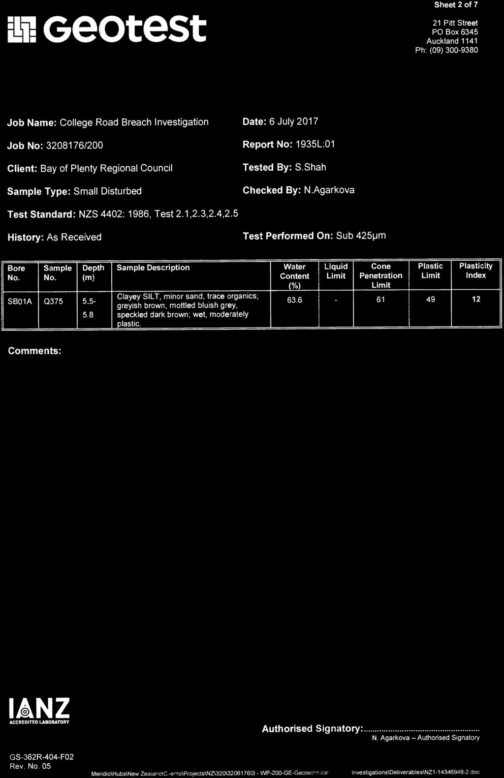
103

104


105


106


107

108


109


110


111
Boreholes. Implementation. Boring. Boreholes may be excavated by one of these methods: 1. Auger Boring 2. Wash Boring 3.
 Implementation Boreholes 1. Auger Boring 2. Wash Boring 3. Rotary Drilling Boring Boreholes may be excavated by one of these methods: 4. Percussion Drilling The right choice of method depends on: Ground
Appendix A. Producer Statement Advisory Note
 Appendix A Producer Statement Advisory Note Ref. No. 17095 26 May 2017 PRODUCER STATEMENT CONSTRUCTION REVIEW (PS4) IMPORTANT ADVISORY NOTE The Building Consent Authority (BCA) frequently requires Producer
LEGEND BUSINESS ZONE NORTH OF AGRESEARCH BOREHOLE CPT SEISMIC CPT AUGER SCALE. Powells Road TEST PIT AGRESEARCH INNOVATION PARK. Hamilton Ring Road
 LEGEND ra R aku Ru BUSINESS ZONE NORTH OF Powells Road oad AGRESEARCH BOREHOLE CPT SEISMIC CPT AUGER SCALE 3 mm TEST PIT AS121 SCPT12 TP18 BH13 TP15 2 AS125 AS126 TP14 BH12 AGRESEARCH CPT13 TP17 INNOVATION
REPORT. Earthquake Commission. Christchurch Earthquake Recovery Geotechnical Factual Report Bryndwr Appendix C: Borehole Logs
 REPORT Earthquake Commission Christchurch Earthquake Recovery Geotechnical Factual Report Bryndwr Appendix C: Borehole Logs REPORT Earthquake Commission Christchurch Earthquake Recovery Geotechnical Factual
Earthquake Commission. Darfield Earthquake Recovery Geotechnical Factual Report Avondale
 REPORT Earthquake Commission Darfield Earthquake Recovery Geotechnical Factual Report Avondale REPORT Earthquake Commission Darfield Earthquake Recovery Geotechnical Factual Report Avondale Report prepared
Depth (ft) USCS Soil Description TOPSOIL & FOREST DUFF
 USCS Soil Description TOPSOIL & FOREST DUFF") Test Pit No. TP-6 Location: Latitude 47.543003, Longitude -121.980441 Approximate Ground Surface Elevation: 1,132 feet Depth (ft) USCS Soil Description 0 1.5 1.5 5.0 SM 5.0 8.0 SM Loose to medium dense,
Test Pit No. TP-6 Location: Latitude 47.543003, Longitude -121.980441 Approximate Ground Surface Elevation: 1,132 feet Depth (ft) USCS Soil Description 0 1.5 1.5 5.0 SM 5.0 8.0 SM Loose to medium dense,
Lake Rotoiti Wastewater Scheme - Stage 1 Investigations. Rotorua Lakes Council
 Lake Rotoiti Wastewater Scheme - Stage 1 Investigations Rotorua Lakes Council i Contents 1 Introduction...1 2 Site Description...1 3 Geological Setting...1 4 Geotechnical Investigation...1 4.1 Borehole
Omaroro Lower Playing Field - Geotechnical Interpretive Report
 Report Omaroro Lower Playing Field - Geotechnical Interpretive Report Prepared for Wellington Water Limited Prepared by Beca Limited 1 December 2017 Omaroro Lower Playing Field - Geotechnical Interpretive
APPENDIX A. Borehole Logs Explanation of Terms and Symbols
 APPENDIX A Borehole Logs Explanation of Terms and Symbols Page 153 of 168 EXPLANATION OF TERMS AND SYMBOLS The terms and symbols used on the borehole logs to summarize the results of field investigation
B-1 BORE LOCATION PLAN. EXHIBIT Drawn By: 115G BROOKS VETERINARY CLINIC CITY BASE LANDING AND GOLIAD ROAD SAN ANTONIO, TEXAS.
 N B-1 SYMBOLS: Exploratory Boring Location Project Mngr: BORE LOCATION PLAN Project No. GK EXHIBIT Drawn By: 115G1063.02 GK Scale: Checked By: 1045 Central Parkway North, Suite 103 San Antonio, Texas 78232
Chapter 12 Subsurface Exploration
 Page 12 1 Chapter 12 Subsurface Exploration 1. The process of identifying the layers of deposits that underlie a proposed structure and their physical characteristics is generally referred to as (a) subsurface
Hydro One (Sept 2014) Hydro One (Sept 2014) Hydro One (Sept 2014)
 Hydro One (Sept 2014) Hydro One (Sept 2014)") TABLE 1 WELL CONSTRUCTION DETAILS MOE WWR No Well ID Location Installation Date Status Easting Coordinates Northing Source Elevation Screened Interval Screened Material Borehole Well Stick-up Ground Top
TABLE 1 WELL CONSTRUCTION DETAILS MOE WWR No Well ID Location Installation Date Status Easting Coordinates Northing Source Elevation Screened Interval Screened Material Borehole Well Stick-up Ground Top
Appendix F Laboratory test results
 Appendix F Laboratory test results SOIL AND ROCK SAMPLE ANALYSIS LABORATORY TEST REPORT To: Bord Gais Copy: Orla Smyth (kkidd@bge.ie) From: Stephen Watson Laboratory Manager Causeway Geotech Ltd Tel: +44(0)2827666640
 Photo 1 - Southerly view across 2700 parking lot toward existing building. Multi-residential building borders western side of property in upper right of view. Photo 2 - Southerly view across 2750 parking
Civil Engineering, Surveying and Environmental Consulting WASP0059.ltr.JLS.Mich Ave Bridge Geotech.docx
 2365 Haggerty Road South * Canton, Michigan 48188 P: 734-397-3100 * F: 734-397-3131 * www.manniksmithgroup.com August 29, 2012 Mr. Richard Kent Washtenaw County Parks and Recreation Commission 2330 Platt
16 January 2018 Job Number: RICHARD NEWMAN C\- CLARK FORTUNE MCDONALD AND ASSOCIATES PO BOX 553 QUEENSTOWN
 16 January 2018 Job Number: 50595 RICHARD NEWMAN C\- CLARK FORTUNE MCDONALD AND ASSOCIATES PO BOX 553 QUEENSTOWN CHANSEN@CFMA.CO.NZ STORMWATER DISPOSAL ASSESSMENT Dear Richard, RDAgritech were requested
SITE INVESTIGATION 1
 SITE INVESTIGATION 1 Definition The process of determining the layers of natural soil deposits that will underlie a proposed structure and their physical properties is generally referred to as site investigation.
 Project: ITHACA-TOMPKINS REGIONAL AIRPORT EXPANSION Project Location: ITHACA, NY Project Number: 218-34 Key to Soil Symbols and Terms TERMS DESCRIBING CONSISTENCY OR CONDITION COARSE-GRAINED SOILS (major
ENCE 3610 Soil Mechanics. Site Exploration and Characterisation Field Exploration Methods
 ENCE 3610 Soil Mechanics Site Exploration and Characterisation Field Exploration Methods Geotechnical Involvement in Project Phases Planning Design Alternatives Preparation of Detailed Plans Final Design
APPENDIX C. Borehole Data
 APPENDIX C Borehole Data MAJOR DIVISIONS SOIL CLASSIFICATION CHART SYMBOLS GRAPH LETTER TYPICAL DESCRIPTIONS ADDITIONAL MATERIAL
APPENDIX A GEOTECHNICAL REPORT
 The City of Winnipeg Bid Opportunity No. 529-2017 Template Version: C420170317 - RW APPENDIX A GEOTECHNICAL REPORT Quality Engineering Valued Relationships KGS Group 2017 Industrial Street Rehabilitation
Pierce County Department of Planning and Land Services Development Engineering Section
 Page 1 of 7 Pierce County Department of Planning and Land Services Development Engineering Section PROJECT NAME: DATE: APPLICATION NO.: PCDE NO.: LANDSLIDE HAZARD AREA (LHA) GEOLOGICAL ASSESSMENT REPORT
 SOIL CLASSIFICATION CHART COARSE-GRAINED SOILS MORE THAN 50% RETAINED ON NO.200 SIEVE FINE-GRAINED SOILS 50% OR MORE PASSES THE NO.200 SIEVE PRIMARY DIVISIONS GRAVELS MORE THAN 50% OF COARSE FRACTION RETAINED
CONTENTS. 1. GeneralsG Field Investigation WorkG Laboratory Testing Work Surface Soil Description-- 7.
 CONTENTS Page 1. GeneralsG 4 2. Field Investigation WorkG 4 3. Laboratory Testing Work--- 5 4. Surface Soil Description-- 7 Appendix A Borehole Location Plan 11 Soil Profile-- 15 Bore Logs--=---- 18 Appendix
Appendix J. Geological Investigation
 Appendix J Geological Investigation Appendix J Geological Environment Table of Contents Page 1 INTRODUCTION...J-1 1.1 Purpose of the Investigation...J-1 1.2 Scope of the Investigation...J-1 2 METHODO OF
The process of determining the layers of natural soil deposits that will underlie a proposed structure and their physical properties is generally
 The process of determining the layers of natural soil deposits that will underlie a proposed structure and their physical properties is generally referred to as sub surface investigation 2 1 For proper
B-1 SURFACE ELEVATION
 5A 5B LOGGED BY El. S. Bhangoo DRILLING CONTRACTOR Pitcher Drilling DRILLING METHOD Rotary Wash BEGIN DATE 12-14-12 SAMPLER TYPE(S) AND SIZE(S) (ID) SPT, MC BOREHOLE BACKFILL AND COMPLETION COMPLETION
DATA REPORT GEOTECHNICAL INVESTIGATION GALVESTON CRUISE TERMINAL 2 GALVESTON, TEXAS
 DATA REPORT GEOTECHNICAL INVESTIGATION GALVESTON CRUISE TERMINAL 2 GALVESTON, TEXAS SUBMITTED TO PORT OF GALVESTON 123 ROSENBERG AVENUE, 8TH FLOOR GALVESTON, TEXAS 77553 BY HVJ ASSOCIATES, INC. HOUSTON,
Geotechnical Engineering Report
 Geotechnical Engineering Report Turner Turnpike Widening Bridge B Bridge Crossing: South 257 th West Avenue Creek County, Oklahoma June 1, 2016 Terracon Project No. 04155197 Prepared for: Garver, LLC Tulsa,
DRILL HOLE # BH-BGC13-FN-01
 DILL HOLE # BH-BGC3-FN-0 Drill Method: Mud otary/coring Depth To ock (m): N/A Page of 7 eviewed by: AJB 0 GAVEL (GW) Fine to coarse, sandy, well graded, dense, max particle size = 30 mm, angular to subrounded,
Manual on Subsurface Investigations National Highway Institute Publication No. FHWA NHI Federal Highway Administration Washington, DC
 Manual on Subsurface Investigations National Highway Institute Publication No. FHWA NHI-01-031 Federal Highway Administration Washington, DC Geotechnical Site Characterization July 2001 by Paul W. Mayne,
BP Connect Development Turangi Preliminary Geotechnical Assessment Report
 The Holmes Group BP Connect Development Turangi Preliminary Geotechnical Assessment Report The Holmes Group BP Connect Development Turangi Preliminary Geotechnical Assessment Report Prepared By Opus International
Gotechnical Investigations and Sampling
 Gotechnical Investigations and Sampling Amit Prashant Indian Institute of Technology Gandhinagar Short Course on Geotechnical Investigations for Structural Engineering 12 14 October, 2017 1 Purpose of
APPENDIX F CORRELATION EQUATIONS. F 1 In-Situ Tests
 APPENDIX F 1 APPENDIX F CORRELATION EQUATIONS F 1 In-Situ Tests 1. SPT (1) Sand (Hatanaka and Uchida, 1996), = effective vertical stress = effective friction angle = atmosphere pressure (Shmertmann, 1975)
GUIDELINE FOR HAND HELD SHEAR VANE TEST
 GUIDELINE FOR HAND HELD SHEAR VANE TEST NZ GEOTECHNICAL SOCIETY INC August 2001 CONTENTS Page 1.0 Introduction 2 2.0 Background 2 3.0 Recommended Practice 3 4.0 Undrained Shear Strength 3 5.0 Particular
1 SITE EXPLORATION PROGRAM
 November 1, 2016 MMM Group Limited 1045 Howe Street, Suite 700 Vancouver, BC, Canada V6Z 2A9 Jianping Jiang, Ph.D., P.Eng Vice President Dear Dr. Jiang: Agassiz-Rosedale Bridge 2016 Fraser River Site Exploration
Turitea Wind Farm - Preliminary Geotechnical Report
 Report Turitea Wind Farm - Preliminary Geotechnical Report July 2006 Mighty River Power report Turitea Wind Farm Preliminary Geotechnical Report Prepared for Mighty River Power By Beca Carter Hollings
(C) Global Journal of Engineering Science and Research Management
 Global Journal of Engineering Science and Research Management") GEOTECHNCIAL ASSESSMENT OF PART OF PORT HARCOURT, NIGER DELTA FOR STRUCTURAL ANALYSIS Warmate Tamunonengiyeofori Geostrat International Services Limited, www.geostratinternational.com. *Correspondence
GEOTECHNCIAL ASSESSMENT OF PART OF PORT HARCOURT, NIGER DELTA FOR STRUCTURAL ANALYSIS Warmate Tamunonengiyeofori Geostrat International Services Limited, www.geostratinternational.com. *Correspondence
Soils. Technical English - I 10 th week
 Technical English - I 10 th week Soils Soil Mechanics is defined as the branch of engineering science which enables an engineer to know theoretically or experimentally the behavior of soil under the action
SI Planning & Laboratory Testing for Hill-Site Development
 SI Planning & Laboratory Testing for Hill-Site Development 21 April 2009 IEM Penang Ir. Tan Yean Chin G&P Geotechnics Sdn Bhd Cameron Highlands, 1961 Genting Highland Tower 1993 Bukit Antarabangsa, 1999
Soil Mechanics Brief Review. Presented by: Gary L. Seider, P.E.
 Soil Mechanics Brief Review Presented by: Gary L. Seider, P.E. 1 BASIC ROCK TYPES Igneous Rock (e.g. granite, basalt) Rock formed in place by cooling from magma Generally very stiff/strong and often abrasive
General. DATE December 10, 2013 PROJECT No TO Mary Jarvis Urbandale/Riverside South Development Corporation
 DATE December 10, 201 PROJECT No. 10-1121-0260- TO Mary Jarvis Urbandale/Riverside South Development Corporation CC Justin Robitaille, Urbandale Jonathan Párraga, J.L. Richards & Associates Limited FROM
Earthquake Commission Darfield Earthquake Recovery Geotechnical Factual Report New Brighton
 REPORT Earthquake Commission Darfield Earthquake Recovery Geotechnical Factual Report New Brighton REPORT Earthquake Commission Darfield Earthquake Recovery Geotechnical Factual Report New Brighton Report
Log of Monitoring Well D58B
 Project: Motiva - Monitoring Well and Soil Boring Data Project Location: Delaware City Refinery Project Number: 20240412.W1000 Log of Monitoring Well D58B Sheet 1 of 7 Date(s) Drilled Drilling Method Drill
10. GEOTECHNICAL EXPLORATION PROGRAM
 Geotechnical site investigations should be conducted in multiple phases to obtain data for use during the planning and design of the tunnel system. Geotechnical investigations typically are performed in
Geotechnical Investigation
 Geotechnical Investigation Slope Stability Analysis for the Existing Slope Southwest of the Proposed Condo Developments 50 Ann Street, Bolton, Ontario Prepared For: Brookfield Homes (Ontario) Limited GeoPro
From - To 0,00-4,90 4,90-6,40 6,40-8,60 8,60-9,60 9,60-10,50 10,50-12,00 12,00-14,80 14,80-15,80 15,80-19,30 19, ,00
 Závěrka 12,Praha 6,169 00 Log of Boring BH1 Project ID: 2018_A-017 Annex no.: A.1G Drilling equipment: Hütte 202 TF Location: Prague 12 Overall depth: 2 m Borehole position: Date start: 22.11.2017 Foreman:
patersongroup Design for Earthquakes Consulting Engineers May 19, 2016 File: PG3733-LET.01
 patersongroup May 19, 2016 File: PG3733-LET.01 Hydro Ottawa Limited c/o Cresa Toronto 170 University Avenue, Suite 1 Toronto, Ontario M5H 3B3 Attention: Ms. Barbara Wright Consulting Engineers 154 Colonnade
KDOT Geotechnical Manual Edition. Table of Contents
 KDOT Geotechnical Manual 2007 Edition The KDOT Geotechnical Manual is available two volumes. Both volumes are very large electronic (pdf) files which may take several minutes to download. The table of
REPORT ON SLOPE STABILITY INVESTIGATION DON MILLS ROAD AND EGLINTON AVENUE EAST TORONTO, ONTARIO. Prepared for:
 REPORT ON SLOPE STABILITY INVESTIGATION DON MILLS ROAD AND EGLINTON AVENUE EAST TORONTO, ONTARIO Prepared for: TORONTO AND REGION CONSERVATION AUTHORITY Prepared By: SIRATI & PARTNERS CONSULTANTS LIMITED
APPENDIX B: BORING LOGS
 New Orleans Levee Systems Independent Levee Hurricane Katrina Investigation Team July, 6 APPENDIX B: BORING S As part of the field investigation 9 borings were performed at the sites of interest, as listed
CENTRAL REGION GEOHAZARDS RISK ASSESSMENT SITE INSPECTION FORM
 SITE NUMBER AND NAME C55 H861:02 Slide LEGAL DESCRIPTION NW 14-40-14-W4 CENTRAL REGION GEOHAZARDS RISK ASSESSMENT SITE INSPECTION FORM HIGHWAY & KM NAD 83 COORDINATES N 5811217 E 437291 PREVIOUS INSPECTION
ADDENDUM 1 FISHER SLOUGH RESTORATION PROJECT SKAGIT COUNTY, WASHINGTON
 F I N A L A D D E N D U M 1 R E P O R T ADDENDUM 1 FISHER SLOUGH RESTORATION PROJECT SKAGIT COUNTY, WASHINGTON REPORT OF GEOTECHNICAL INVESTIGATION URS JOB NO. 3376186 Prepared for Tetra Tech Inc. 142
GEOTECHNICAL INVESTIGATION REPORT PROPOSED MIXED USE DEVELOPMENT 54 PARKWAY DRIVE ROSEDALE, AUCKLAND
 K170412-1 9 August 2017 GEOTECHNICAL INVESTIGATION REPORT PROPOSED MIXED USE DEVELOPMENT 54 PARKWAY DRIVE ROSEDALE, AUCKLAND Prepared For: Lucy Li c/- DCS Ltd Unit 67 Victoria Park Market PO Box 91247,
REPORT. Housing Re-Zone. Middle Road and Iona Road - Geotechnical Investigation Report
 REPORT Housing Re-Zone Middle Road and Iona Road - Geotechnical Investigation Report Prepared for Hastings istrict Council Prepared by Tonkin & Taylor Ltd ate April 06 Job Number 464.000 istribution: Hastings
14 Geotechnical Hazards
 Volume 2: Assessment of Environmental Effects 296 14 Geotechnical Hazards Overview This Chapter provides an assessment of the underlying geotechnical conditions to identify: any potential liquefaction
Geotechnical Indications Of Eastern Bypass Area In Port Harcourt, Niger Delta
 Geotechnical Indications Of Eastern Bypass Area In Port Harcourt, Niger Delta Warmate Tamunonengiyeofori Geostrat International Services Limited, Rivers State, Nigeria www.geostratinternational.com info@geostratinternational.com,
Geotechnical Engineering Report
 Geotechnical Engineering Report Turner Turnpike Widening Bridge D Bridge Crossing: South 209 th West Avenue Creek County, Oklahoma June 1, 2016 Terracon Project No. 04155197 Prepared for: Garver, LLC Tulsa,
June 9, R. D. Cook, P.Eng. Soils Engineer Special Services Western Region PUBLIC WORKS CANADA WESTERN REGION REPORT ON
 PUBLIC WORKS CANADA WESTERN REGION REPORT ON GEOTECHNICAL INVESTIGATION PROPOSED MARTIN RIVER BRIDGE MILE 306.7 MACKENZIE HIGHWAY Submitted by : R. D. Cook, P.Eng. Soils Engineer Special Services Western
Geotechnical Engineering Report
 Geotechnical Engineering Report Turner Turnpike Widening Polecat Creek Bridge (Bridge A) June 1, 2016 Terracon Project No. 04155197 Prepared for: Garver, LLC Prepared by: Terracon Consultants, Inc. TABLE
Safe bearing capacity evaluation of the bridge site along Syafrubesi-Rasuwagadhi road, Central Nepal
 Bulletin of the Department of Geology Bulletin of the Department of Geology, Tribhuvan University, Kathmandu, Nepal, Vol. 12, 2009, pp. 95 100 Safe bearing capacity evaluation of the bridge site along
SCOPE OF INVESTIGATION Simple visual examination of soil at the surface or from shallow test pits. Detailed study of soil and groundwater to a
 Lecture-5 Soil Exploration Dr. Attaullah Shah 1 Today s Lecture Purpose of Soil Exploration Different methods 1. Test trenches and Pits 2. Auger and Wash Boring 3. Rotary Drilling 4. Geophysical Methods
GEOTECHNICAL INVESTIGATION REPORT
 GEOTECHNICAL INVESTIGATION REPORT SOIL INVESTIGATION REPORT FOR STATIC TEST FACILITY FOR PROPELLANTS AT BDL, IBRAHIMPATNAM. Graphics Designers, M/s Architecture & Engineering 859, Banjara Avenue, Consultancy
THE INSTITUTE OF COST ACCOUNTANTS OF INDIA (ICAI)
") THE INSTITUTE OF COST ACCOUNTANTS OF INDIA (ICAI) GEOTECHNICAL INVESTIGATION REPORT FOR PROPOSED PROJECT INSTITUTIONAL BUILDING FOR ICAI AT CBD BELAPUR, NAVI MUMBAI OCTOBER 2012 1281-2012-073 BY THANE
THE INSTITUTE OF COST ACCOUNTANTS OF INDIA (ICAI) GEOTECHNICAL INVESTIGATION REPORT FOR PROPOSED PROJECT INSTITUTIONAL BUILDING FOR ICAI AT CBD BELAPUR, NAVI MUMBAI OCTOBER 2012 1281-2012-073 BY THANE
A. V T = 1 B. Ms = 1 C. Vs = 1 D. Vv = 1
 Geology and Soil Mechanics 55401 /1A (2002-2003) Mark the best answer on the multiple choice answer sheet. 1. Soil mechanics is the application of hydraulics, geology and mechanics to problems relating
Appendix F Geotechnical Investigation
 Appendix F Geotechnical Investigation Cie Sucriere de Bel Ombre Ltee Residential Development at Bel Ombre Environmental Impact Assessment F1 Geotechnical Investigation This appendix includes the Factual
UAS Student Residence
 General Notes, Abbreviations and Symbols C100 MATCH LINE - SEE SHEET L6 Existing Site Topographic Conditions C101 MATCH LINE - SEE SHEET L5 Existing Site Topographic Conditions C102 DEPTH(FT.) 5 FROZEN
BOREHOLE LOCATION PLAN
 BH2/Probe A BH1 Light cable percussion drilling rig Windowless Sampling Borehole and Dynamic Penetration Probing CLIENT: SITE: Date: Abingdon Hydro Ltd Abingdon Hydro Project, Nr Abingdon Wier August 2014
GEOTECHNICAL REPORT. Matanuska-Susitna Borough. Parks Highway Connections Museum Drive. Matanuska-Susitna Borough, Alaska.
 Matanuska-Susitna Borough GEOTECHNICAL REPORT Parks Highway Connections Museum Drive Matanuska-Susitna Borough, Alaska March 2, 20 Prepared By: John Thornley, PE Geotechnical Engineer 333 Arctic Blvd.,
Geotechnical Data Report
 Geotechnical Data Report Downtown Greenville Future Conveyance Study December 1, 2015 Terracon Project No. 86155032 Prepared for: Prepared by: Terracon Consultants, Inc. December 1, 2015 561 Mauldin Road
NAPLES MUNICIPAL AIRPORT
 NAPLES MUNICIPAL AIRPORT NAPLES MUNICIPAL AIRPORT (APF) TAXIWAY D REALIGNMENT AND DRAINAGE IMPROVEMENTS NORTH QUADRANT ADDENDUM NUMBER TWO March, The following Addendum is hereby made a part of the Plans
Technical Memorandum. Soil Borings
 Technical Memorandum To: Project File and Appendix F to Sediment Remedial Investigation Report From: Sara L. Leow, PE Subject: Geotechnical Investigation and Results Summary Date: February 213 Project:
Preston Downs Lot 295/296 Geotechnical Subdivision Report GW West Melton Limited
 Preston Downs Lot 295/296 Geotechnical Subdivision Report GW West Melton Limited 17 March 2017 Revision: 1 Reference: 253852 Document control record Document prepared by: Aurecon New Zealand Limited Unit
Site Investigations and Geotechnical Risk For Underground Construction Greg Raines, PE
 August 14, 2017 Site Investigations and Geotechnical Risk For Underground Construction Greg Raines, PE Gregory.Raines@Stantec.com Develop Preliminary Geologic / Geotech Conceptual Model for the Project
VOLUME III GEOLOGY, HYDROGEOLOGY & GEOTECHNICAL REPORT CAPITAL REGION RESOURCE RECOVERY CENTRE
 VOLUME III GEOLOGY, HYDROGEOLOGY & GEOTECHNICAL REPT CAPITAL REGION RESOURCE RECOVERY CENTRE APPENDIX A Borehole Records December Report No. //vol III LIST OF ABBREVIATIONS The abbreviations coonly employed
APPENDIX C HYDROGEOLOGIC INVESTIGATION
 Figure B-5.7 Figure B-5.8 Preliminary Geotechnical and Environmental Report Appendix C Hydrogeologic Investigation APPENDIX C HYDROGEOLOGIC INVESTIGATION December 21, 2011 WESTSIDE SUBWAY EXTENSION PROJECT
PRELIMINARY GEOTECHNICAL ENGINEERING REPORT. Proposed Re-Development 44 Old Worcester Road Charlton, Massachusetts. Prepared For:
 PRELIMINARY GEOTECHNICAL ENGINEERING REPORT Proposed Re-Development 44 Old Worcester Road Charlton, Massachusetts Prepared For: Meridian Associates, Inc. 500 Cummings Center, Suite 5950 Beverly, Massachusetts
Geology and Soil Mechanics /1A ( ) Mark the best answer on the multiple choice answer sheet.
 Mark the best answer on the multiple choice answer sheet.") Geology and Soil Mechanics 55401 /1A (2003-2004) Mark the best answer on the multiple choice answer sheet. 1. Soil mechanics is the application of hydraulics, geology and mechanics to problems relating
Geology and Soil Mechanics 55401 /1A (2003-2004) Mark the best answer on the multiple choice answer sheet. 1. Soil mechanics is the application of hydraulics, geology and mechanics to problems relating
New Plymouth CBD Site Subsoil Class: Results from ground investigation
 Alexander, G.J., Chin, C.Y., Kayser, C. & Bradshaw, J. (2017) New Plymouth CBD Site Subsoil Proc. 20 th NZGS Geotechnical Symposium. Eds. GJ Alexander & CY Chin, Napier New Plymouth CBD Site Subsoil Class:
The attitude he maintains in his relation to the engineer is very well stated in his own words:
 Su bsurface Soil Exploration, 53: 139 Foundation Engineering Geotechnical companies that have a history of experience in a given region usually have extensive boring logs and maps telling where the borings
Appendix G GEOLOGICAL INVESTIGATION
 Appendix G GEOLOGICAL INVESTIGATION JOB NUMBER: 3268.001 DATE: 10-14-13 BY: CC SITE 0 2000 1"=2000' VICINITY MAP CARGILL PARCEL HICKORY STREET AND ENTERPRISE DRIVE NEWARK, CALIFORNIA FOR
IN SITU SPECIFIC GRAVITY VS GRAIN SIZE: A BETTER METHOD TO ESTIMATE NEW WORK DREDGING PRODUCTION
 IN SITU SPECIFIC GRAVITY VS GRAIN SIZE: A BETTER METHOD TO ESTIMATE NEW WORK DREDGING PRODUCTION Nancy Case O Bourke, PE 1, Gregory L. Hartman, PE 2 and Paul Fuglevand, PE 3 ABSTRACT In-situ specific gravity
Conventional Field Testing & Issues (SPT, CPT, DCPT, Geophysical methods)
") Conventional Field Testing & Issues (SPT, CPT, DCPT, Geophysical methods) Ajanta Sachan Assistant Professor Civil Engineering IIT Gandhinagar Conventional Field Testing 1 Field Test: In-situ shear strength
Conventional Field Testing & Issues (SPT, CPT, DCPT, Geophysical methods) Ajanta Sachan Assistant Professor Civil Engineering IIT Gandhinagar Conventional Field Testing 1 Field Test: In-situ shear strength
Pore pressure response during high frequency sonic drilling and SPT
 Wentz, F.J. & Dickenson S.E. (2013) Proc. 19 th NZGS Geotechnical Symposium. Ed. CY Chin, Queenstown Pore pressure response during high frequency sonic drilling and SPT sampling in liquefiable sand F J
BR-01 PAINT BRIDGE NO. 55 C GENERAL PLAN 720'-0" VC 605'-0" VC 1. FOR INDEX TO PLANS, QUANTITIES, AND GENERAL NOTES, SEE "INDEX TO PLANS" SHEET.
 2'-" VC 6'-" VC BB EB 1 1 1 1 1 TV - " TV CONDUITS (COX E 8 - " ELECTRIC CONDUITS (SDG & E T - " TELEPHONE CONDUITS 1. FOR INDEX TO PLANS, QUANTITIES, AND GENERAL NOTES, SEE "INDEX TO PLANS" SHEET. 2.
Underground Risk Management Course Marina Del Rey, California November, Geotechnical Data Reports. Greg Raines, PE
 Underground Risk Management Course Marina Del Rey, California November, 2018 Geotechnical Data Reports Greg Raines, PE Gregory.Raines@Stantec.com Introduction What is a Geotechnical Data Report? The GDR
SLOPE STABILITY ASSESSMENT PROPOSED RESIDENTIAL SUBDIVISION 161 LAKESHORE ROAD EAST TOWN OF THE BLUE MOUNTAINS, ONTARIO
 SLOPE STABILITY ASSESSMENT PROPOSED RESIDENTIAL SUBDIVISION 161 LAKESHORE ROAD EAST TOWN OF THE BLUE MOUNTAINS, ONTARIO PETO MacCALLUM LTD. 19 CHURCHILL DRIVE BARRIE, ONTARIO L4N 8Z5 PHONE: (705) 734-3900
M E M O R A N D U M. Mr. Jonathan K. Thrasher, P.E., Mr. Ian Kinnear, P.E. (FL) PSI
 PSI") M E M O R A N D U M TO: FROM: Mr. Mark Schilling Gulf Interstate Engineering Mr. Jonathan K. Thrasher, P.E., Mr. Ian Kinnear, P.E. (FL) PSI DATE: November 11, 2014 RE: Summary of Findings Geotechnical
M E M O R A N D U M TO: FROM: Mr. Mark Schilling Gulf Interstate Engineering Mr. Jonathan K. Thrasher, P.E., Mr. Ian Kinnear, P.E. (FL) PSI DATE: November 11, 2014 RE: Summary of Findings Geotechnical
Eastwood & Partners St. Andrew's House 23 Kingfield Road Sheffield S11 9AS. Co-ords: Level: Dimensions: Depth 1.50m
 epth (m) 0.0 Kingfield Road S AS Coords: imensions: epth.0m epth Level (m) (m AO) Stratum escription 0.0m.0m TOPSOIL: Brown sandy gravelly with rootlets. Gravel is angular to subrounded fine to coarse
ATTACHMENT A PRELIMINARY GEOTECHNICAL SUMMARY
 ATTACHMENT A PRELIMINARY GEOTECHNICAL SUMMARY Kevin M. Martin, P.E. KMM Geotechnical Consultants, LLC 7 Marshall Road Hampstead, NH 0384 603-489-6 (p)/ 603-489-8 (f)/78-78-4084(m) kevinmartinpe@aol.com
CONQUEST ENGINEERING LTD.
 CONQUEST ENGINEERING LTD. Geotechnical and Materials Engineers Concrete Technology, Blasting Consultants Construction Quality Assurance / Quality Control 8 Bluewater Road, Bedford, NS BB J6 Phone (9)85-7
Soil type identification and fines content estimation using the Screw Driving Sounding (SDS) data
 data") Mirjafari, S.Y. & Orense, R.P. & Suemasa, N. () Proc. th NZGS Geotechnical Symposium. Eds. GJ Alexander & CY Chin, Napier Soil type identification and fines content estimation using the Screw Driving Sounding
Mirjafari, S.Y. & Orense, R.P. & Suemasa, N. () Proc. th NZGS Geotechnical Symposium. Eds. GJ Alexander & CY Chin, Napier Soil type identification and fines content estimation using the Screw Driving Sounding
Cone Penetration Testing in Geotechnical Practice
 Cone Penetration Testing in Geotechnical Practice Table Of Contents: LIST OF CONTENTS v (4) PREFACE ix (2) ACKNOWLEDGEMENTS xi (1) SYMBOL LIST xii (4) CONVERSION FACTORS xvi (6) GLOSSARY xxii 1. INTRODUCTION
PLATE 6 FEB G r o v e l a n d F l o o d w a l l - B o r e h o l e M a p. Legend. Groveland Floodwall Boreholes. Contour Lines.
 611 6 Defau FALS conto Conto DPLV lt Eurs20 01_to 3po Defau FALS conto Conto DPLV lt Eurs20 01_to 4po 612 Conto DPLV conto Defau FALS 01_to urs20 Elt po 5 Conto DPLV conto Defau FALS 01_to urs15 Elt po
 R-1 Conveyor Relocation Project Legend 0 500 1000 1500 ft. This map is a user generated static output from an Internet mapping site and is for general reference only. Data layers that appear on this map
CITY OF VALDEZ Project Title: East Pioneer Reconstruction Project No.: Contract No.: TO: All Recipients Date: April 14, 2014
 CITY OF VALDEZ Project Title: East Pioneer Reconstruction Project No.: 13-3-1.32 Contract No.: 11 TO: All Recipients Date: April 14, 214 SUBJECT: Addendum No.1 This seventeen (17) page Addendum forms a
Terraprobe Consulting Geotechnical & Environmental Engineering Construction Materials Inspection & Testing
 Terraprobe Consulting Geotechnical & Environmental Engineering Construction Materials Inspection & Testing GEOTECHNICAL INVESTIGATION BLOCKS TO PIER HAMILTON, ONTARIO PREPARED FOR: City of Hamilton Waterfront
CITY OF CAPE CORAL NORTH 2 UTILITIES EXTENSION PROJECT CONTRACT 3
 GEOTECHNICAL REPORT CITY OF CAPE CORAL NORTH UTILITIES EXTENSION PROJECT CONTRACT City of Cape Coral Procurement Division Cultural Park Boulevard, nd Floor Cape Coral, FL ISSUED FOR BID VOLUME of GEOTECHNICAL
Ardaman & Associates, Inc. Geotechnical, Environmental and Materials Consultants
 SUBSURFACE SOIL EXPLORATION 42-INCH FORCE MAIN REPLACEMENT CHIQUITA BOULEVARD S AND SW 34 TH STREET CAPE CORAL, LEE COUNTY, FLORIDA Ardaman & Associates, Inc. Geotechnical, Environmental and Materials
TRANSPORT SCOTLAND A9 DUALLING SOUTHERN SECTION NOTES ON EXPLORATORY HOLE RECORDS GENERAL NOTES. Contract No. G151043U Appendix A Rev KS/01
 1 OPERATING PROCEDURES GENERAL NOTES The procedure used for cable percussion boring, rotary drilling, trial pitting, sampling, in situ and laboratory testing and sample descriptions are generally in accordance