Supplementary material
|
|
|
- Howard Ferguson
- 5 years ago
- Views:
Transcription
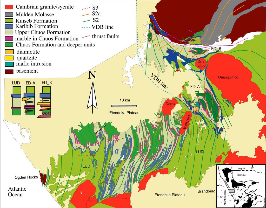
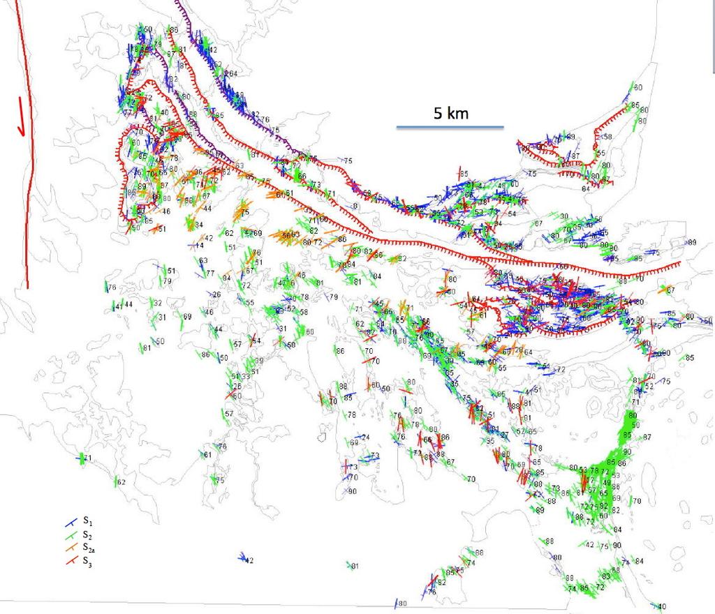
1 GSA Data Repository How to make a transverse triple junction New evidence for the assemblage of Gondwana along the Kaoko-Damara belts, Namibia Passchier et al. Supplementary material Details of the structures observed in the Lower Ugab Domain (LUD) and eastern domain (ED), except the newly discovered D 2a phase, have earlier been published in Maeder et al., 2007, 2014 and Passchier et al., 2002, 2007, 2011, while details of the stratigraphy were published in Swart, 1992; Paciullo et al., 2007 and Nascimento et al., The relationship of the structures in relevant publications is summarised in Table DR1. Details of granite dating in the LUD were given in Schmitt et al., 2008, In this supplementary section, we only show more recent, unpublished structural data from the NW part of the ED, near Vrede. Fig. DR1 shows the lithological boundaries and formations that occur in the area, and summarised stratigraphic sections. This stratigraphy is only shown as outlines in the LUD in Fig. 2. Figure DR2 shows details of the orientation of S 1, L 1, S 2, S 2a and S 3 in the NE part of Fig. DR1. For correlation with earlier work, we stress that recognition of D 2a structures throughout the region gave rise to a reinterpretation of the deformation sequence for the area. In previous publications, S 1 in the ED was correlated with the first foliation in the LUD, but recent work has shown that the earliest structures in the LUD must correlate with the second deformation event (D 2 ) in the ED. In our earlier publications (Maeder et al., 2007, 2014; Passchier et al., 2002, 2007, 2011, and Schmitt et al., 2007, 2012) and in publications by Gray et al. (2006, 2008) and Goscombe et al. (2003a, 2003b, 2004, 2005), regional deformation phases D 2 and D 2a in the LUD as described in this publication, were therefore referred to as D 1 and D 2 respectively. In area ED-A in Fig. DR1, also known as the Goantagab domain, D 2a was earlier referred to as D 2b in Passchier et al., D 2 and D 3 have been previously described (Miller, 2008; Passchier et al., 2011; Lehmann et al., 2016) while D 2a is a newly recognised phase. Some of the D 3 structures described in earlier work (e.g. Passchier et al., 2007, Lehmann et al., 2016) are probably D 2a features. Figure DR1. Simplified geological map of the LUD and ED, as reproduced in Fig. 2. In this map, formations are given which are only shown as contours in the LUD in Fig. 2. Simplified stratigraphic columns (after Nascimento et al., 2016) show the stratigraphic differences between the LUD and ED. Fig. DR2. Tectonic map showing the distribution of observed S 1, S 2 and S 2a in the NE part of Figure 2. This map was the basis of the tectonic contours shown in Fig. 2. Contours from other areas in Fig.2 were derived from maps in Passchier et al., (2007, 2011) and Maeder et al., (2014). References Goscombe, B., Hand, M., Gray, D.R., 2003a,, Structure of the Kaoko Belt, Namibia: progressive evolution of a classic transpressional orogen: Journal of Structural Geology, v. 25, p Goscombe, B., Hand, M., Gray, D.R., Mawby, J., 2003b, The metamorphic architecture of a transpressional orogen: the Kaoko Belt, Namibia: Journal of Petrology, v. 44, p Goscombe, B., Gray, D.R., Hand, M., 2004, Variation in metamorphic style along the northern margin of the Damara Orogen, Namibia: Journal of Petrology, v. 45, p Goscombe, B., Gray, D.R., Hand, M., 2005, Extrusional tectonics in the core of a transpressional
2 orogen: the Kaoko Belt, Namibia. Journal of Petrology, v. 46, p Gray, D.R., Forster, D.A., Goscombe, B., Passchier, C.W., Trouw, R.A.J., 2006, 40Ar/39Ar thermochronology of the Pan African Damara Orogen, Namibia, with implications for tectonothermal and geodynamic evolution: Precambrian Research, v. 150, p Gray, D.R. Foster, D.A., Meert, J.G., Goscombe, B.D., Armstrong, R., Trouw, R.A.J., Passchier, C.W., 2008, A Damara orogen perspective on the assembly of southwestern Gondwana: London, Geological Society [London] Special Publication 294, p Hoffman, P.F., Swart, R., Freyer, E.E., Guowei, H., 1994, Damara Orogen of Northwest Namibia. In: Niall, M., McManus, C. (Eds.), Geological Excursion Guide of the international conference Proterozoic crustal and metallogenic evolution. Geological Society and the Geological Survey of Namibia. 55 pp. Maeder, X., Passchier, C.W., Trouw, R.A.J., 2007, Flame foliation: Evidence for a schistosity formed normal to the extension direction: Journal of Structural Geology, v. 29, p Nascimento, D.B., Ribeiro, A., Trouw, R.A.J., Schmitt, R.S., Passchier, C.W., 2016, Stratigraphy of the Neoproterozoic Damara Sequence in northwest Namibia: slope to basin sub-marine masstransport deposits and olistolith fields: Precambrian Research, in press. Paciullo, F.V.P., Ribeiro, A., Trouw, R.A.J., Passchier, C.W., 2007, Facies and facies association of the siliciclastic Brak River and carbonate Gemsbok formations in the Lower Ugab River valley, Namibia, W Africa: Journal of African Earth Sciences v. 47, p Passchier, C.W., Trouw, R.A.J. Ribeiro, A., Paciullo F.V.P., 2002, Tectonic evolution of the southern Kaoko belt, Namibia: Journal of African Earth Sciences, v. 35, p Schmitt, R.S., Trouw, R.A.J., Van Schmus, W.R., Passchier, C.W., 2008, Cambrian orogeny in the Ribeira Belt (SE Brazil) and correlations within West Gondwana: Ties that bind underwater. Geological Society, London, Special Publications v. 294, p Swart, R., 1992, The sedimentology of the Zerrissene turbidite system, Damara Orogen, Namibia: Memoir of the Geological Survey of Namibia, v. 13, p. 54.
3 Fig. DR1
4 Fig. DR2
5 TABLE DR1. RELATIONSHIP OF STRUCTURAL PHASES AS PUBLISHED IN THE LITERATURE, AND IN THIS PUBLICATION LUD ED Hoffman et al 1994; Passchier et al., 2002, 2007; D1 D2 D3 D1 D2 D3 Miller, 2008; Maeder et al., 2007, 2014; Schmitt et al., 2007, 2012 Passchier et al., 2011 D1 D2 D3 D1 D2 D2b D3 This publication D2 D2a D3 D1 D2 D2a D3
Dome formation mechanisms in the southwestern Central Zone of the Damara Orogen, Namibia
 Trabajos de Geología, Universidad de Oviedo, 29 : 440-444 (2009) Dome formation mechanisms in the southwestern Central Zone of the Damara Orogen, Namibia L. LONGRIDGE 1*, R. L. GIBSON 1 AND J. A. KINNAIRD
Tectonic evolution of the southern Kaoko belt, Namibia
 Journal of African Earth Sciences 35 (2002) 61 75 www.elsevier.com/locate/jafrearsci Tectonic evolution of the southern Kaoko belt, Namibia C.W. Passchier a, *, R.A.J. Trouw b, A. Ribeiro b, F.V.P. Paciullo
Regional GIS based exploration targeting studies in data poor environments
 Regional GIS based exploration targeting studies in data poor environments A case study of gold prospectivity mapping in Nigeria Matthew Greentree, Mathieu Lacorde and Bert De Waele Acknowledgements Australian
Global Tectonics. Kearey, Philip. Table of Contents ISBN-13: Historical perspective. 2. The interior of the Earth.
 Global Tectonics Kearey, Philip ISBN-13: 9781405107778 Table of Contents Preface. Acknowledgments. 1. Historical perspective. 1.1 Continental drift. 1.2 Sea floor spreading and the birth of plate tectonics.
Gondwana Research 52 (2017) Contents lists available at ScienceDirect. Gondwana Research. journal homepage:
 Contents lists available at ScienceDirect. Gondwana Research. journal homepage:") Gondwana Research 52 (2017) 153 171 Contents lists available at ScienceDirect Gondwana Research journal homepage: www.elsevier.com/locate/gr Depositional ages and provenance of the Neoproterozoic Damara
Gondwana Research 52 (2017) 153 171 Contents lists available at ScienceDirect Gondwana Research journal homepage: www.elsevier.com/locate/gr Depositional ages and provenance of the Neoproterozoic Damara
Event geochronology of the Pan-African Kaoko Belt, Namibia
 Precambrian Research 140 (2005) 103.e1 103.e41 Event geochronology of the Pan-African Kaoko Belt, Namibia Ben Goscombe a,, David Gray a, Richard Armstrong b, David A. Foster c, James Vogl c a School of
Flame foliation: Evidence for a schistosity formed normal to the extension direction
 Journal of Structural Geolog (2006) 1e7 www.elsevier.com/locate/jsg Flame foliation: Evidence for a schistosit formed normal to the etension direction Xavier Maeder a, *, Cees W. Passchier a, Rudolph A.J.
IMSG Post-conference Field Guide
 IMSG 2017 - Post-conference Field Guide Jérémie Lehmann, Marlina Elburg and Trishya Owen-Smith The purpose of this short field excursion on Wednesday 18 January is to show a variety of rocks that make
Junior Research Fellowship in Geology. Test Code: RG (Short answer + Objective type) 2010
 2010") Junior Research Fellowship in Geology Test Code: RG (Short answer + Objective type) 2010 The candidates for Junior Research Fellowship in Geology will have to take two tests- Test GM in the forenoon session
Junior Research Fellowship in Geology Test Code: RG (Short answer + Objective type) 2010 The candidates for Junior Research Fellowship in Geology will have to take two tests- Test GM in the forenoon session
Prepare by: Pars Geological Research Center (Arian Zamin) August 2012
 August 2012") Prepare by: Pars Geological Research Center (Arian Zamin) August 2012 Position, boundaries and area of Iran Iran is located in southwest of the Continent of Asia like a bridge connecting three continents
Prepare by: Pars Geological Research Center (Arian Zamin) August 2012 Position, boundaries and area of Iran Iran is located in southwest of the Continent of Asia like a bridge connecting three continents
Bulletin of Earth Sciences of Thailand
 Quantitative Seismic Geomorphology of Early Miocene to Pleistocene Fluvial System of Northern Songkhla Basin, Gulf of Thailand Oanh Thi Tran Petroleum Geoscience Program, Department of Geology, Faculty
Ore Deposits and Mantle Plumes
 Ore Deposits and Mantle Plumes by Franco Pirajno Geological Survey of Western Australia, Perth, Australia KLUWER ACADEMIC PUBLISHERS DORDRECHT / BOSTON / LONDON CONTENTS PREFACE ACKNOWLEDGEMENTS INTRODUCTION
Structure of the western Brooks Range fold and thrust belt, Arctic Alaska
 Trabajos de Geología, Universidad de Oviedo, 29 : 218-222 (2009) Structure of the western Brooks Range fold and thrust belt, Arctic Alaska J. DE VERA 1* AND K. MCCLAY 2 1Now at: Shell, Rijswijk, Netherlands.
GONDWANA 14 East Meets West Field Trip PostGo1 - Ribeira and Brasília belts in the context of West Gondwana
 GONDWANA 14 East Meets West Field Trip PostGo1 - Ribeira and Brasília belts in the context of West Gondwana The aim of the field trip is to discuss the tectonic episodes of West Gondwana amalgamation in
Case Study of the Structural and Depositional-Evolution Interpretation from Seismic Data*
 Case Study of the Structural and Depositional-Evolution Interpretation from Seismic Data* Yun Ling 1, Xiangyu Guo 1, Jixiang Lin 1, and Desheng Sun 1 Search and Discovery Article #20143 (2012) Posted April
THE CONGO-KALAHARI CRATONIC RELATIONSHIP: FROM RODINIA TO GONDWANA
 THE CONGO-KALAHARI CRATONIC RELATIONSHIP: FROM RODINIA TO GONDWANA By BRITTANY LYNN NEWSTEAD A THESIS PRESENTED TO THE GRADUATE SCHOOL OF THE UNIVERSITY OF FLORIDA IN PARTIAL FULFILLMENT OF THE REQUIREMENTS
GLY 155 Introduction to Physical Geology, W. Altermann. Press & Siever, compressive forces. Compressive forces cause folding and faulting.
 Press & Siever, 1995 compressive forces Compressive forces cause folding and faulting. faults 1 Uplift is followed by erosion, which creates new horizontal surface. lava flows Volcanic eruptions cover
DEFORMATION AND METAMORPHISM OF THE AILEU FORMATION, EAST TIMOR. R. F. Berry (B.Sc. Hons.) SCHOOL OF EARTH SCIENCES. May 1979
 SCHOOL OF EARTH SCIENCES. May 1979") DEFORMATION AND METAMORPHISM OF THE AILEU FORMATION, EAST TIMOR. by R. F. Berry (B.Sc. Hons.) SCHOOL OF EARTH SCIENCES FLINDERS UNIVERSITY OF SOUTH AUSTRALIA May 1979 i TABLE OF CONTENTS page Table of
DEFORMATION AND METAMORPHISM OF THE AILEU FORMATION, EAST TIMOR. by R. F. Berry (B.Sc. Hons.) SCHOOL OF EARTH SCIENCES FLINDERS UNIVERSITY OF SOUTH AUSTRALIA May 1979 i TABLE OF CONTENTS page Table of
Copyright McGraw-Hill Education. All rights reserved. No reproduction or distribution without the prior written consent of McGraw-Hill Education
 Copyright McGraw-Hill Education. All rights reserved. No reproduction or distribution without the prior written consent of McGraw-Hill Education Tibetan Plateau and Himalaya -southern Asia 11.00.a VE 10X
SEDIMENTARY BASINS Red Sea Coast of Egypt. by Prof. Dr. Abbas Mansour
 SEDIMENTARY BASINS Red Sea Coast of Egypt by Prof. Dr. Abbas Mansour Sedimentary basins Sedimentary basins are, in a very broad sense, all those areas in which sediments can accumulate to considerable
UNIVERSITY OF PRETORIA Department of Geology HISTORICAL GEOLOGY - GLY 161 SEMESTER EXAM
 UNIVERSITY OF PRETORIA Department of Geology HISTORICAL GEOLOGY - GLY 161 SEMESTER EXAM Internal examiner: Dr A.J. Bumby. External examiner: Prof. P.G. Eriksson Copyright Reserved 20 th November 2009 Time:
Field Trips through southern Nevada and eastern California SUMMARY REPORT
 Field Trips through southern Nevada and eastern California SUMMARY REPORT Submitted to: Offshore Energy Research Association of Nova Scotia (OERA) to fulfill the requirements of the Student Research Travel
NAMAQUA METAMORPHIC PROVINCE FIELD TRIP
 - 2016 NAMAQUA METAMORPHIC PROVINCE FIELD TRIP Theme: GEOLOGY AND ORIGIN OF A VERY LARGE HOT OROGEN - THE HIGH-T-LOW-P NAMAQUA METAMORPHIC PROVINCE 21-27 August 2016 Pre-conference field trip Geology to
Controls on clastic systems in the Angoche basin, Mozambique: tectonics, contourites and petroleum systems
 P2-2-13 Controls on clastic systems in the Angoche basin, Mozambique: tectonics, contourites and petroleum systems Eva Hollebeek, Olivia Osicki, Duplo Kornpihl Schlumberger, London, UK Introduction Offshore
REGISTRATION INFORMATION AND FORM. Copper in Namibia, Copper Exploration, Mining & Processing
 REGISTRATION INFORMATION AND FORM Copper in Namibia, Copper Exploration, Mining & Processing 13 th and 14 th September 2012 Venue: Ministry of Mines & Energy Auditorium, Windhoek The Geological Society
HDR/EGS POTENTIAL OF THE VILKYCIAI AREA, WEST LITHUANIA
 HDR/EGS POTENTIAL OF THE VILKYCIAI AREA, WEST LITHUANIA Prepared by Saulius Sliaupa, Dainius Michelevicius, Gediminas Motuza, Larisa Korabliova, Kirstina Ciuraite West Lithuania is situated in the central
Red Sea Basins. by Prof. Dr. Abbas Mansour
 Red Sea Basins TECTONO-SEDIMENTARY EVOLUTION OF THE NW PARTS OF THE RED SEA The pre-rift rift by Prof. Dr. Abbas Mansour 1.a. The Precambrian basement and the inherited structural pattern of the rift
Isan deformation, magmatism and extensional kinematics in the Western Fold Belt of the Mount Isa Inlier
 Isan deformation, magmatism and extensional kinematics in the Western Fold Belt of the Mount Isa Inlier Rick Gordon Department of Earth Sciences University of Queensland A thesis submitted for examination
Small-Scale Deformational Structures as Significant Shear-Sense Indicators: An example from Almora Crystalline Zone, Kumaun Lesser Himalaya
 e-journal Earth Science India, Vol. I (III), 2008, pp. 119-124 http://www.earthscienceindia.info/ Small-Scale Deformational Structures as Significant Shear-Sense Indicators: An example from Almora Crystalline
Detailed Sedimentology and Inorganic Geochemistry of the Dolgeville Formation and Utica Group of the Central Mohawk Valley, NY
 Detailed Sedimentology and Inorganic Geochemistry of the Dolgeville Formation and Utica Group of the Central Mohawk Valley, NY Daniel Miserendino Jeffrey T. Pietras Introduction and Purpose Drill cores
Kilometre-Scale Uplift of the Early Cretaceous Rift Section, Camamu Basin, Offshore North-East Brazil*
 Kilometre-Scale Uplift of the Early Cretaceous Rift Section, Camamu Basin, Offshore North-East Brazil* Iain Scotchman 1 and Dario Chiossi 2 Search and Discovery Article #50183 (2009) Posted May 20, 2009
SAND DISTRIBUTION AND RESERVOIR CHARACTERISTICS NORTH JAMJUREE FIELD, PATTANI BASIN, GULF OF THAILAND
 SAND DISTRIBUTION AND RESERVOIR CHARACTERISTICS NORTH JAMJUREE FIELD, PATTANI BASIN, GULF OF THAILAND Benjawan KIinkaew Petroleum Geoscience Program, Department of Geology, Faculty of Science, Chulalongkorn
Bird River Belt in southeastern Manitoba: a Neoarchean volcanic arc in the Western Superior Province. Paul Gilbert Manitoba Geological Survey
 Bird River Belt in southeastern Manitoba: a Neoarchean volcanic arc in the Western Superior Province Paul Gilbert Manitoba Geological Survey Location of Bird River Belt Bird River Belt Winnipeg Bird River
Earthscope in the Northern Rockies Workshop
 Earthscope in the Northern Rockies Workshop Co-conveners: David Foster - University of Florida Paul Mueller - University of Florida David Mogk - Montana State University EarthScope in the Northern Rockies
Large-Scale Stratigraphic Architecture of a Deep-Water Slope Conduit, Nanaimo Group, Hornby Island, Canada
 Large-Scale Stratigraphic Architecture of a Deep-Water Slope Conduit, Nanaimo Group, Hornby Island, Canada Heather A. Bain 1 and Stephen M. Hubbard 1 1 Department of Geoscience, University of Calgary Introduction
Sequence Stratigraphy, Ore Deposits, and Africa The Influence of Dr. Eric Cheney!
 GSA Vancouver, BC Oct. 21, 2014 A Sequence Stratigraphic View of the Roan Group Host to the World s Largest Sedimentary Rock-hosted Stratiform Copper District, Central Africa Mindola Pit, Zambia Murray
Carboniferous Stoddart Group: An integrated approach
 Carboniferous Stoddart Group: An integrated approach Abu Yousuf*, Department of Geoscience, University of Calgary, Calgary, Alberta yousufabu@hotmail.com and Charles M. Henderson, Department of Geoscience,
General Geologic Setting and Seismicity of the FHWA Project Site in the New Madrid Seismic Zone
 General Geologic Setting and Seismicity of the FHWA Project Site in the New Madrid Seismic Zone David Hoffman University of Missouri Rolla Natural Hazards Mitigation Institute Civil, Architectural & Environmental
Geosciences Career Pathways (Including Alternative Energy)
") Geosciences Career Pathways (Including Alternative Energy) Shale Carbonates Clastics Unconventionals Geology Characterization and Production Properties of Gas Shales Geomechanics in International Shale
Geosciences Career Pathways (Including Alternative Energy) Shale Carbonates Clastics Unconventionals Geology Characterization and Production Properties of Gas Shales Geomechanics in International Shale
UNCONVENTIONAL OIL & GAS POTENTIAL IN PORTUGAL
 UNCONVENTIONAL OIL & GAS POTENTIAL IN PORTUGAL Nuno PIMENTEL, LISBON UNIVERSITY Rui PENA DOS REIS, COIMBRA UNIVERSITY www.meg.ipn.pt UNCONVENTIONAL OIL & GAS POTENTIAL IN PORTUGAL GEOLOGICAL BACKGROUND
A Perspective on a Three Dimensional Framework for Canadian Geology
 A Perspective on a Three Dimensional Framework for Canadian Geology H.A.J. Russell, B. Brodaric, G. Keller, K.E. McCormack, D.B. Snyder, and M.R. St-Onge GSA Vancouver, 2014 Author Affiliations H.A.J.
Regional Trends in the Geology. Hercynian-Mauritanide Orogen. of the Appalachian-Caledonian- G.Kelling. Paul E. Schenk. R.T.Haworth. P. F.
 Regional Trends in the Geology of the Appalachian-Caledonian- Hercynian-Mauritanide Orogen edited by Paul E. Schenk Department of Geology, Dalhousie University, Halifax, Nova Scotia, Canada Associate editors
Petroleum Potential of the Application Area L12-4
 Petroleum Potential of the Application Area L12-4 The Application Area (L12-4) is underlain by the western Officer Basin, beneath the Gunbarrel Basin. The general basin architecture is outlined in Figure
EXISTING GEOLOGICAL INFORMATION
 CHAPER 3 EXISTING GEOLOGICAL INFORMATION 3-1 General Geology of the Surrounding Area (1) General geology and ore deposits in Mongolia Geographically, Mongolia is a country located between Russia to the
Structural Geology of the Mountains
 Structural Geology of the Mountains Clinton R. Tippett Shell Canada Limited, Calgary, Alberta clinton.tippett@shell.ca INTRODUCTION The Southern Rocky Mountains of Canada (Figure 1) are made up of several
GEL 113 Historical Geology
 GEL 113 Historical Geology COURSE DESCRIPTION: Prerequisites: GEL 111 Corequisites: None This course covers the geological history of the earth and its life forms. Emphasis is placed on the study of rock
3.3. Tectonics of Rifting and Drifting: Pangea Breakup
 N.B., FOR BEST RESULTS, PRINT AT 85% Previous Next 3.3. Tectonics of Rifting and Drifting: Pangea Breakup 3.3.2. Extracting Tectonic Information from Cores in Rift Basins Roy W. Schlische Department of
The Late Tertiary Deep-Water Siliciclastic System of the Levant Margin - An Emerging Play Offshore Israel*
 The Late Tertiary Deep-Water Siliciclastic System of the Levant Margin - An Emerging Play Offshore Israel* Michael A. Gardosh 1, Yehezkel Druckman 2 and Binyamin Buchbinder 2 Search and Discovery Article
Kaaimansgat Inlier: A Keystone of the Cape Fold Belt
 Kaaimansgat Inlier: A Keystone of the Cape Fold Belt Geological Society of South Africa Western Cape Branch End-of-Year Field Trip 29 November 08 Scott Maclennan and Christie Rowe Department of Geological
From Rodinia to Pangea: Geodynamics, Life and Climate
 IGCP 648 2018 Field Symposium in south China From Rodinia to Pangea: Geodynamics, Life and Climate Place: Yichang, Three Gorges region in South China Time: 2018, November 1-9 General information South
Parts of the Sevier/ Laramide Orogeny
 Parts of the Sevier/ Laramide Orogeny AA. Accretionary Prism BB. Forearc Basin Sediment scraped off of subducting plate Sediment derived from the volcanic arc CC. Volcanic Arc Magmatic intrusion into the
GCE A level 1215/03 GEOLOGY - GL5 THEMATIC UNIT 3 GEOLOGICAL EVOLUTION OF BRITAIN
 Surname Other Names Centre Number 2 Candidate Number GCE A level 1215/03 GEOLOGY - GL5 THEMATIC UNIT 3 GEOLOGICAL EVOLUTION OF BRITAIN P.M. FRIDAY, 10 June 2011 ONE of TWO units to be completed in 2 hours
Southern Songkhla Basin, Gulf of Thailand
 Architecture and Depositional Environment of Fluvial Systems of Southern Songkhla Basin, Gulf of Thailand Toan Manh Do Petroleum Geoscience Program, Department of Geology, Faculty of Science, Chulalongkorn
predictive mineral discovery*cooperative Research Centre A legacy for mineral exploration science Mineral Systems Q4 Fluid flow drivers & pathways
 Mineral Systems Q4 Fluid flow drivers & pathways 1 Key Parameter Mineral System Exploration is reflected in scale-dependent translation A. Gradient in hydraulic potential B. Permeability C. Solubility
Geodynamics of congested subduction zones - implications for evolution of the Tasmanides
 Geodynamics of congested subduction zones - implications for evolution of the Tasmanides Pete Betts - School of Earth, Atmosphere, and environment, Monash University Louis Moresi Department of Earth Sciences,
Instituto De Ingenieros De Minas Del Peru
 The Continuity Challenge Dr. Wayne Barnett The Interpretation! Great geological continuity? Huge potential? The Reality Not what it might seem... Not what it might seem... Presentation Objective Highlight
SPECIALIST GEOLOGY SERVICES
 SPECIALIST GEOLOGY SERVICES rpsgroup.com/energy RPS ENERGY an independent global energy consultancy RPS Energy is part of RPS Group which has been listed on the main London Stock Exchange since 1995. It
Rheological controls on the geometry of the Currawong VHMS Deposit, Lachlan Fold Belt, Victoria, SE Australia
 PACRIM 2015 Conference Paper Number: 16.00 Rheological controls on the geometry of the Currawong VHMS Deposit, Lachlan Fold Belt, Victoria, SE Australia T.G. Blenkinsop 1, D. Macklin 2 and R. Hammond 3
Controls on facies distributions in the Charlie Lake Formation, Peace River Arch, Alberta
 Controls on facies distributions in the Charlie Lake Formation, Peace River Arch, Alberta E.L. Percy 12, C. Frostad 2, A. Juska 2, C. Schmidt 2, C. Sitzler 2, and J.P. Zonneveld 3 University of Calgary,
Airborne gravity gradiometer surveying of petroleum systems under Lake Tanganyika, Tanzania
 Airborne gravity gradiometer surveying of petroleum systems under Lake Tanganyika, Tanzania D. Roberts Beach Energy P. Roy Chowdhury CGG S. J. Lowe CGG A. N. Christensen CGG Outline Introduction Geology
Supplementary Material
 GSA Data Repository item 2018118 Brardinoni, F., Picotti, V., Maraio, S., Paolo Bruno, P., Cucato, M., Morelli, C., and Mair, V., 2018, Postglacial evolution of a formerly glaciated valley: Reconstructing
1. Be able to explain how the development of a magnetosphere affected the evolution of Earth s atmosphere (3) Atmosphere 1. Be able to describe the
 Atmosphere 1. Be able to describe the") I. Evolution 1. be able to define biologic evolution. 2. be able to define and apply the principles of Natural Selection. 3. be able to describe Gregor Mendel s experiment with pea plants. a) be able to
I. Evolution 1. be able to define biologic evolution. 2. be able to define and apply the principles of Natural Selection. 3. be able to describe Gregor Mendel s experiment with pea plants. a) be able to
Structural Style and Tectonic Evolution of the Nakhon Basin, Gulf of Thailand
 Structural Style and Tectonic Evolution of the Nakhon Basin, Gulf of Thailand Piyaphong Chenrai Petroleum Geoscience Program, Department of Geology, Faculty of Science, Chulalongkorn University, Bangkok
Geology of Neoproterozoic to Cambrian Adelaide Geosyncline and Cambrian Delamerian Orogen
 Geology of Neoproterozoic to Cambrian Adelaide Geosyncline and Cambrian Delamerian Orogen W. V. Preiss Geological Survey Branch, PIRSA Link line traverses Flinders Ranges to join western end of E-W Curnamona
predictive mineral discovery*cooperative Research Centre A legacy for mineral exploration science Mineral Systems Q1 Architecture
 Mineral Systems Q1 Architecture 1 Key Parameter Mineral System Exploration is reflected in scale-dependent translation A. Gradient in hydraulic potential B. Permeability C. Solubility sensitivity to P,
GENERAL GEOLOGY Fall Chapter 18: The Sea Floor. Partial Examination IV Study Guide Dr. Glen S. Mattioli
 GENERAL GEOLOGY 1113-005 Fall 2008 Partial Examination IV Study Guide Dr. Glen S. Mattioli Note that these are NOT questions, but rather are a list of topics that we have covered either in class or are
Introduction to: The Rocky Mountain Region An Evolving Lithosphere: Tectonics, Geochemistry, and Geophysics
 Introduction to: The Rocky Mountain Region An Evolving Lithosphere: Tectonics, Geochemistry, and Geophysics Karl E. Karlstrom Department of Earth and Planetary Sciences, University of New Mexico, Albuquerque,
TS Tectonics & Structural Geology Orals and PICOs Monday, 08 April
 TS Tectonics & Structural Geology Orals and PICOs Monday, 08 April MO1, 08:30 10:00 MO2, 10:30 12:00 MOL, 12:15 13:15 MO3, 13:30 15:00 MO4, 15:30 17:00 GD3.3/GM3.3/GMPV16/TS4.7, The evolution of plate
Meandering Miocene Deep Sea Channel Systems Offshore Congo, West Africa
 Meandering Miocene Deep Sea Channel Systems Offshore Congo, West Africa S. Baer* (PGS), J. E. Comstock (PGS), K. Vrålstad (PGS), R. Borsato (PGS), M. Martin (PGS), J.P. Saba (SNPC), B. Débi-Obambé (SNPC)
CHAPTER 4 POTENTIAL FIELD MODELLING
 CHAPTER 4 POTENTIAL FIELD MODELLING POTENTIAL FIELD MODELLING The reference dataset used for the potential field modelling is the Gravity anomaly map and Magnetic anomaly map of the Atlantic region of
Topics Laramide Orogeny: Late Cretaceous to Early Eocene Reading: GSA DNAG volume 3, Ch. 6
 Topics Laramide Orogeny: Late Cretaceous to Early Eocene Reading: GSA DNAG volume 3, Ch. 6 Late Cretaceous to early Eocene New patterns developed 5 main regions Tectonic interpretations Post-Laramide events
IRAQ. Target Exploration. Geodynamic Evolutions of The Sedimentary Basins of. This study is a major reference for Petroleum
 barr Target Exploration Target Exploration Geodynamic Evolutions of The Sedimentary Basins of IRAQ This study is a major reference for Petroleum Explorationists on the tectonics, stratigraphy, sedimentary
Undergraduate Review. Jessica Sousa. Volume 4 Article 13
 Undergraduate Review Volume 4 Article 13 2008 Kinematic Analysis of Mylonitic Rocks, Southern Ruby Mountains, SW Montana: Evidence for Proterozoic Orogenic Crustal Thickening and Topographic Collapse Jessica
Hildebrand Analysis: Topic 4
 Steven Plescia 12/9/16 Hildebrand Analysis: Topic 4 Hildebrand interprets much of the classic late pc-paloezoic Cordilleran miogeocline as exotic to North America Is there a break in the detrital zircons
Geological Society, London, Special Publications A Damara orogen perspective on the assembly of southwestern Gondwana
 Geological Society, London, Special Publications A Damara orogen perspective on the assembly of southwestern Gondwana D. R. Gray, D. A. Foster, J. G. Meert, B. D. Goscombe, R. Armstrong, R. A. J. Trouw
Passive Margin Structure Constrained by Geophysical Studies. Ricardo Trindade
 Passive Margin Structure Constrained by Geophysical Studies Ricardo Trindade 3 Departments: Astronomy (31 faculty members) Geophysics (20 faculty members) Atmospheric Sciences (18 faculty members) 3 INCT-CNPq,
GSTT Technical Note. September 4, Field Trip - Northern Range. Western (Mid-Crustal) Tectonic Domain. STOP 1: Upper Lady Chancellor Road
 Tectonic Domain. STOP 1: Upper Lady Chancellor Road") GSTT Technical Note September 4, 2001 P.O. Box 3524, La Romain, Trinidad and Tobago W.I Web address: www.gstt.org, Editor: millikm1@bp.com Field Trip - Northern Range Systematic east to west variations
GSTT Technical Note September 4, 2001 P.O. Box 3524, La Romain, Trinidad and Tobago W.I Web address: www.gstt.org, Editor: millikm1@bp.com Field Trip - Northern Range Systematic east to west variations
North Greenland collection of oblique aerial photographs - (Twin Otter photos)
") North Greenland collection of oblique aerial photographs - (Twin Otter photos) The Geological Survey of Greenland (now part of the Geological Survey of Denmark and Greenland: GEUS) carried out a systematic
North Greenland collection of oblique aerial photographs - (Twin Otter photos) The Geological Survey of Greenland (now part of the Geological Survey of Denmark and Greenland: GEUS) carried out a systematic
II CENTRAL & NORTH ATLANTIC CONJUGATE MARGINS CONFERENCE
 http://metododirecto.pt/cm2010 ISBN: 978-989-96923-1-2 Volume VII p. 18-22 II CENTRAL & NORTH ATLANTIC CONJUGATE MARGINS CONFERENCE The Combined Effect of Sedimentation Rate and Salt Tectonics on the Angolan
Ordovician. System. Cambrian. System
 443 495 543 Late Middle Early Late Middle Early Ordovician System Cambrian System Earth History, Ch. 13 1 Ch. 13 Review: Early Paleozoic life & Burgess Shale fauna Most animal phyla originated in Cambrian;
NAME OF THE PROGRAMME : M.Sc. GEOLOGY PROGRAMME OUTCOME
 NAME OF THE PROGRAMME : M.Sc. GEOLOGY PROGRAMME OUTCOME 1. Understanding development of landforms through Earth's external processes by various geological agents; marine processes and formation of marine
Supplementary Table DR1. Detrital zircon age data sorted according to geographic region
 GSA Data Repository 2019154 Barham, M., Kirkland, C.L., and Hollis, J., 2019, Spot the difference: Zircon disparity tracks crustal evolution: Geology, https://doi.org/10.1130/g45840.1 Supplementary Table
Figure 1. Examples of vector displacement diagrams for two and three-plate systems.
 Figure 1. Examples of vector displacement diagrams for two and three-plate systems. Figure 2. Relationships between pole of rotation, great circles, ridge segments, small circles, transforms and fracture
The Sorong Fault Zone Kinematics: The Evidence of Divergence and Horsetail Structure at NW Bird's Head and Salawati Basin, West Papua, Indonesia*
 The Sorong Fault Zone Kinematics: The Evidence of Divergence and Horsetail Structure at NW Bird's Head and Salawati Basin, West Papua, Indonesia* Putri Riadini 1 and Benyamin Sapiie 2 Search and Discovery
History of Earth. Chapter 9: HISTORY OF EARTH. The Solar System. Early Earth: A Giant Impact! Early Earth. Formation of the Solar System
 Chapter 9: HISTORY OF EARTH The Essential Earth, 2 nd Edition Thomas H. Jordan & John Grotzinger History of Earth Earth is 4.56 Billion Years Old Earth has experienced a rich and diverse history that we
Student: Leah Morgan Mentor: Kiram Lezzar. Introduction
 Tectonic controls of sedimentary pathways and depocenters: Canyon conveyor belts and ridge rubbish on the Luiche River Platform Margin, Lake Tanganyika Student: Leah Morgan Mentor: Kiram Lezzar Introduction
Source Depth Determination from Aeromagnetic Data of Ilesha, Southwest Nigeria, Using the Peters Half Slope Method
 Earth Science Research; Vol. 3, No. 1; 2014 ISSN 1927-0542 E-ISSN 1927-0550 Published by Canadian Center of Science and Education Source Depth Determination from Aeromagnetic Data of Ilesha, Southwest
Evolution of Continents Chapter 20
 Evolution of Continents Chapter 20 Does not contain complete lecture notes. Mountain belts Orogenesis the processes that collectively produce a mountain belt Includes folding, thrust faulting, metamorphism,
7 Sedimentation and tectonics at a mid- Ordovician to Silurian active margin
 80 Mountain Building in Scotland 7 Sedimentation and tectonics at a mid- Ordovician to Silurian active margin 7.1 Introduction In mid-ordovician to Silurian times, the Grampian mountains underwent exhumation,
Chapter 2. Tectonic Setting of Australia. 2.1 Archaean Cratons
 Chapter 2 Tectonic Setting of Australia The Australian continent comprises a number of different tectonic blocks: Archaean and Proterozoic blocks in the western and central parts and relatively younger
GEOLOGY OF PRAGUE ITS INTERACTION WITH THE PRAGUE METRO
 Underground M3 meeting, November 3-5, 2008, Prague GEOLOGY OF PRAGUE ITS INTERACTION WITH THE PRAGUE METRO Svatoslav Chamra Department of Geotechnics Faculty of Civil Engineering Czech Technical University
Search and Discovery Article #41255 (2014)** Posted February 11, 2014
** Posted February 11, 2014") Correlating Porosity with Acoustic Impedance in Sandstone Gas Reservoirs: Examples from the Atokan Sandstones of the Arkoma Basin, Southeastern Oklahoma* Ibrahim Çemen 1, Jeff Fuchs 1, Bill Coffey 2, Rodney
Correlating Porosity with Acoustic Impedance in Sandstone Gas Reservoirs: Examples from the Atokan Sandstones of the Arkoma Basin, Southeastern Oklahoma* Ibrahim Çemen 1, Jeff Fuchs 1, Bill Coffey 2, Rodney
TECHNICAL REPORT: REGIONAL GEOLOGY AND TECTONICS Resume. Huachon Project, Cerro de Pasco departments, Peru. By: AFC Logistic SAC
 TECHNICAL REPORT: REGIONAL GEOLOGY AND TECTONICS Resume Huachon Project, Cerro de Pasco departments, Peru By: AFC Logistic SAC December 2016 1. INTRODUCTION GPM Metals Peru, in its portfolio of generating
Ch. 12 Proterozoic Eon
 Ch. 12 Proterozoic Eon Proterozoic Eon is ~ 1.95 billion years in duration, from 2.5 Ga to 0.543 Ga 2.5 Ga 1.6 Ga 1.0 Ga 0.54 Ga Paleoproterozoic Era Mesoproterozoic Era Neoproterozoic Era PROTEROZOIC
L.K. Carr 1, R.J. Korsch 1, A.J. Mory 2, R.M. Hocking 2, S.K. Marshall 1, R.D. Costelloe 1, J. Holzschuh 1, J.L. Maher 1. Australia.
 STRUCTURAL AND STRATIGRAPHIC ARCHITECTURE OF WESTERN AUSTRALIA S FRONTIER ONSHORE SEDIMENTARY BASINS: THE WESTERN OFFICER AND SOUTHERN CARNARVON BASINS L.K. Carr 1, R.J. Korsch 1, A.J. Mory 2, R.M. Hocking
PETROLEUM GEOSCIENCES GEOLOGY OR GEOPHYSICS MAJOR
 PETROLEUM GEOSCIENCES GEOLOGY OR GEOPHYSICS MAJOR APPLIED GRADUATE STUDIES Geology Geophysics GEO1 Introduction to the petroleum geosciences GEO2 Seismic methods GEO3 Multi-scale geological analysis GEO4
Chapter I: Introduction
 Chapter I: Introduction The Central African Copperbelt straddles Zambia and the Democratic Republic of Congo (D.R.C., ex-zaïre), between the 25 th and 29 th East meridians and between the 11 th and 13
INTRODUCTION. Basalt, the widespread igneous rock on the earth sur-face. today appear to have been equally important
 INTRODUCTION Basalt, the widespread igneous rock on the earth sur-face today appear to have been equally important in the geologic past. Basaltic rocks are mostly partial melting products of the upper
Interaction between Faults and Igneous Intrusions in Sedimentary Basins: Insights from 3D Seismic Reflection Data*
 Interaction between Faults and Igneous Intrusions in Sedimentary Basins: Insights from 3D Seismic Reflection Data* Craig Magee¹, Christopher A. Jackson¹, and Nick Schofield² Search and Discovery Article
Aptian/Albian Reservoir Development in the Jeanne d Arc Basin, Offshore Eastern Canada
 Aptian/Albian Reservoir Development in the Jeanne d Arc Basin, Offshore Eastern Canada Jonathan Marshall, Statoil Canada Ltd. Calgary, Alberta, Canada. jomars@statoil.com Introduction: The Jeanne d Arc