GSTT Technical Note. September 4, Field Trip - Northern Range. Western (Mid-Crustal) Tectonic Domain. STOP 1: Upper Lady Chancellor Road
|
|
|
- Phyllis Peters
- 5 years ago
- Views:
Transcription


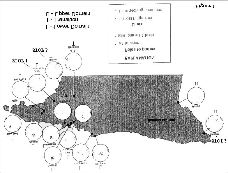
1 GSTT Technical Note September 4, 2001 P.O. Box 3524, La Romain, Trinidad and Tobago W.I Web address: Editor: Field Trip - Northern Range Systematic east to west variations in deformation temperatures, structural fabrics and structural architecture models, Northern Range, Trinidad Dr. John Weber Grand Valley State University Allendale, MI 49401, U.S.A. With contributions by: Dr. David Ferrill, Andrew McCarthy, Dr. Christian Teyssier Introduction On April 29, 2000 Dr. John Weber led GSTT members on a Field trip to the Northern Range, Trinidad. The main objective of this one-day trip was to study systematic changes in deformation temperatures and structural fabrics from east to west across the Northern Range. Western (Mid-Crustal) Tectonic Domain STOP 1: Upper Lady Chancellor Road Rocks in the western Northern Range are ductilely deformed, mid-crustal, metasedimentary rocks, including quartz schist, carbonate schist, and mica schist. D1 deformation temperatures of C are interpreted (Weber et al. in press) from the reset zircon fission tracks and completely recrystallized calcite (Type 5) and quartz (Regime 3) microstructures found in this rock unit. These rocks have subhorizontal D1 fabrics with E-W stretching lineations. Frey et al. (1988) presented an excellent study of metamorphic mineral paragenesis in the range, which demonstrated that the rocks experienced peak metamorphic temperatures of C. The study however did not resolve internal variations in grade across the range. This trip will examine features related to the east-west increase in D1 deformation temperatures (~metamorphic grade) and variation of structural fabrics (subhorizontal to subvertical) documented in Weber et al. (in press). D1 was the earliest and most pervasive deformation event in the range; it produced the majority of the fabrics that will be observed. The two main field stops (Lady Chancellor Road and Tompire Bay, Figure 1) are representative endmembers that will encourage participants to contrast the rocks, structures, and fabrics, in the structurally lower western domain with those in the overlying eastern domain, Figure2. Supplemental microstructural color photo-micrographs (from Weber et al. in press) were shown on the outcrop, and maps presenting results from Weber et al. (in press) geothermometry study were provided in this field guide. Fig 1: Outcrop of quartz-mica and carbonate schist along the Lady Chancellor Road, western Northern Range. Note late (F2) fold (kink) of S1 metamorphic oliation (layering), which in general dips gently (20-30 degrees or less) across much of the western and central Northern Range 1
. This intense shape change (i.e., strain) is manifested in the ubiquitous tight-isoclinal D1 folds and an intense, pervasive S1 foliation that makes up the dominant layering in these rocks.")
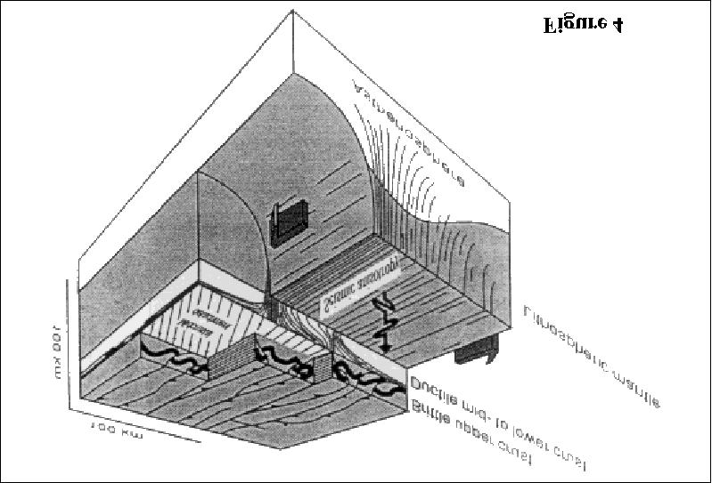
2 Most original sedimentary features in the rocks, including their original stratigraphy, have been destroyed by the intense ductile shape changes that these rocks have experienced (~10:1 flattening and stretching). This intense shape change (i.e., strain) is manifested in the ubiquitous tight-isoclinal D1 folds and an intense, pervasive S1 foliation that makes up the dominant layering in these rocks. Transposition is the name given to the process of the replacement of an old rock layering, in this case bedding (S0), with a new tectonic layering (S 1). The current largescale structural model for the Northern Range is that of a northward overturned macroscopic anticline (Potter, 1973; Algar 1993). This model is perhaps inappropriate as it is based on correlating a now nonexistent protolithic stratigraphy across the transposed rocks in the western Northern Range. Throughout the trip emphasis was placed on discussing the on-going attempts at building a new structural architecture model(s) for the Northern range (e.g., Weber et al. in review). Put simply, the Northern Range can be an intact crustal block that is tilted and plunging toward the east. Relatively highgrade, mid-crustal rocks would be exposed in the western Northern Range. Traversing eastward across the range, the exposures should systematically grade into the upper crustal rocks of the Toco district. Eastern And Northeastern (Upper Crustal) Tectonic Domains The rocks in the eastern Northern Range are a mixed bag of upper crustal rocks, which can be divided into an eastern and northeastern domain. The northeastern domain includes the San Souci basalt, Toco mélange (Algar, 1993), shallowly dipping and largely overturned Galera outcrops, and regions of subhorizontal moderat ely dipping S1 (e.g., between Toco and Matelot). Only reconnaissance-level work has been done in these rocks and these northeastern domain rocks will not be examined on this trip. Eastern (Upper Crustal) Tectonic Domain STOP 2: Tompire Bay, Guyamara Point. Many of the metasedimentary rocks (slates, metasandstones, and metacarbonates) in the eastern Northern Range tectonic have preserved upright (subvertical) D1 fabrics (e.g., see the map of Barr 1965) with geometries and kinematics akin to those at the surface in the Central Range. Fig 2: Folded bedding (S0) at Tompire Bay, south of the Toco region, Northern Range. S1 slaty cleaveage is well developed in metamudstone beds in fold nose. In general both bedding (S0) and cleavage (S1) are upright(subvertical) across much of the eastern Northern Range These include: folds with subvertical, NE -SW striking axial planes, and subhorizontal NE-SW trending hinges; dextral thrusts (Weber and Ferrill in press). Although they have similar structures, the eastern Northern Range domain rocks however have been buried to greater depths than those presently at the surface in the Central Range. The eastern Northern Range domain rocks have non-reset zircon fission tracks, type III calcite twins, and regime 1-2 quartz microstructures, indicating upper-crustal D1 deformation temperatures of C (Weber et al. in press). Weber et al. (in review) propose that the upright fabrics in this domain are part of a patch of the upper crustal foldthrust-strike-slip belt that has not been eroded off the top of the low, eastern end of the Northern Range (Figs 3 & 4). 2
 to conclude that the most recent motions have been down-to-the-south normal faulting along this")
3 discussed above. The range-front faults and shear bands observed here were interpreted by Weber et al (in press) to conclude that the most recent motions have been down-to-the-south normal faulting along this boundary. Weber et al. (in press) interpreted that such range-front normal fault displacement decreased from east-to-west, causing the eastward tilting of the Northern Range, and the east-to-west D1 deformation temperature differential discussed above. References Algar, S.T., Structural, stratigraphic, and thermo-chronological evolution of Trinidad. Ph.D. thesis, Dartmouth College. Barr, K.W., The Geology of the Toco District, Trinidad, W.I. Overseas Geological Surveys. Her Majesty's Stationary Office, London Davis, G.H., and Reynolds, S., Structural Geology of Rocks and Regions. John Wiley and Sons, New York. 2 nd ed., 776 pp. Fig 3 Range-Front Sub-Domain STOP 3: Lower Lady Chancellor Road, Champs Fleurs This additional stop examines the structures along the southern boundary of the Northern Range. Range-front upright folding is geometrically identical to that in the eastern (upper) domain, but the rangefront folds are folds of the S1 foliation, not bedding (S0). These rocks and structures are interpreted to be transitional, having formed at structural levels spanning those of both the upper and lower domains Frey, M., Saunders, J., Schwander, H., The mineralogy and matamorphic geology of low-grade metasediments, Northern Range, Trinidad. Journal of the Geological Society of London 145, Potter, H.C., The overturned anticline of the Northern Range near Port of Spain. Journal of the Geological Society of London 129, Weber, J.C. Ferrill, D.A., in press. Structural Geology of the Tompire Bay outcrops, eastern Northern Range, Trinidad. For Proceedings of 15th Caribbean Geological Conference. Weber, J.C., Ferrill, D.A. and Roden-Tice, M.K., in press. Calcite and quartz microstructural geothermometry of lowgrade metasedimentary rocks, Northern Ramge, Trinidad. 3
 2.")
4 STRUCTURAL CODING SYSTEM (Davis and Reynolds, 1996) D i = Deformation event; i = 1, 2, F i = A "generation" of folds produced during a deformation event; i = 1, 2, eg. F 1 folds form during D 1, etc. Types of Folds: 1. Buckle folds or Free folds (wave trains) 2. Fault-related (fault-bend, fault-propogation) or forced folds (no wave trains only single fold) S i = A planar foliation (new tectonic/ metamorphic layering reflecting shape change - flattening ) produced during a deformation event; i = 1, 2, ** NOTE: So is reserved for sedimementary bedding or other primary layering ** Types of Foliation: 1. Schistosity 2. Slaty cleavage 3. Other Generally a single deformation evemt produces folds with an axial planar foliation Transposition - replacement of old layering by new tectonic layering via deformation. 4
5 5
6 6
Chapter 15 Structures
 Chapter 15 Structures Plummer/McGeary/Carlson (c) The McGraw-Hill Companies, Inc. TECTONIC FORCES AT WORK Stress & Strain Stress Strain Compressive stress Shortening strain Tensional stress stretching
Stress and Strain. Stress is a force per unit area. Strain is a change in size or shape in response to stress
 Geologic Structures Geologic structures are dynamically-produced patterns or arrangements of rock or sediment that result from, and give information about, forces within the Earth Produced as rocks change
Lecture 6 Folds, Faults and Deformation Dr. Shwan Omar
 Fold: A fold is a bend or wrinkle of rock layers or foliation; folds form as a sequence of ductile deformation. Folding is the processes by which crustal forces deform an area of crust so that layers of
GEOL 321 Structural Geology and Tectonics
 GEOL 321 Structural Geology and Tectonics Geology 321 Structure and Tectonics will be given in Spring 2017. The course provides a general coverage of the structures produced by brittle and ductile rock
GEOLOGICAL INVESTIGATION IN THE ISLAND LAKE GREENSTONE BELT, NORTHWESTERN SUPERIOR PROVINCE, MANITOBA (PARTS OF NTS 53E/15 & 16) GS-18
 GS-18") GS-18 GEOLOGICAL INVESTIGATION IN THE ISLAND LAKE GREENSTONE BELT, NORTHWESTERN SUPERIOR PROVINCE, MANITOBA (PARTS OF NTS 53E/15 & 16) by S. Lin, H.D.M. Cameron, E.C. Syme and F. Corfu 1 Lin, S., Cameron,
GS-18 GEOLOGICAL INVESTIGATION IN THE ISLAND LAKE GREENSTONE BELT, NORTHWESTERN SUPERIOR PROVINCE, MANITOBA (PARTS OF NTS 53E/15 & 16) by S. Lin, H.D.M. Cameron, E.C. Syme and F. Corfu 1 Lin, S., Cameron,
Study the architecture and processes responsible for deformation of Earth s crust. Folding and Faulting
 Crustal Deformation AKA Structural geology (adapted from Brunkel, 2012) Study the architecture and processes responsible for deformation of Earth s crust. Folding and Faulting How Rocks Deform: 4 Controls
GG303 Lecture 29 9/4/01 1 FABRICS
 GG303 Lecture 29 9/4/01 1 FABRICS I Main Topics A What are fabrics? B Planar fabrics C Linear fabrics D Penetrative vs. non-penetrative fabrics E Cleavage and folds F Comments on use of grain-scale observations
Structural Geology and Geology Maps Lab
 Structural Geology and Geology Maps Lab Mesa College Geology 101 Lab Ray Rector: Instructor Structural Geology Lab Pre-Lab Resources Pre-Lab Internet Links 1) Fundamentals of Structural Geology 2) Visualizing
Structure and history of the Kern Canyon fault system: introduction and thesis overview
 1 Chapter 1 Structure and history of the Kern Canyon fault system: introduction and thesis overview Exposures of fault zones from the surface to deep levels afford an opportunity to study the transition
Stratigraphy and structure of the Ganson Hill area: northern Taconic Allochthon
 University at Albany, State University of New York Scholars Archive Geology Theses and Dissertations Atmospheric and Environmental Sciences 1985 Stratigraphy and structure of the Ganson Hill area: northern
Geologic Structures. Changes in the shape and/or orientation of rocks in response to applied stress
 Geologic Structures Changes in the shape and/or orientation of rocks in response to applied stress Figure 15.19 Can be as big as a breadbox Or much bigger than a breadbox Three basic types Fractures >>>
GY403 Structural Geology. Tectonite Fabrics
 GY403 Structural Geology Tectonite Fabrics Tectonite Fabric A tectonite is a rock that possess a penetrative fabric consisting of cleavage, foliation and/or lineation Tectonite fabrics are associated with
Part I. PRELAB SECTION To be completed before labs starts:
 Student Name: Physical Geology 101 Laboratory #13 Structural Geology II Drawing and Analyzing Folds and Faults Grade: Introduction & Purpose: Structural geology is the study of how geologic rock units
Dome formation mechanisms in the southwestern Central Zone of the Damara Orogen, Namibia
 Trabajos de Geología, Universidad de Oviedo, 29 : 440-444 (2009) Dome formation mechanisms in the southwestern Central Zone of the Damara Orogen, Namibia L. LONGRIDGE 1*, R. L. GIBSON 1 AND J. A. KINNAIRD
What Causes Rock to Deform?
 Crustal Deformation Earth, Chapter 10 Chapter 10 Crustal Deformation What Causes Rock to Deform? Deformation is a general term that refers to all changes in the shape or position of a rock body in response
2 Britain s oldest rocks: remnants of
 Britain s oldest rocks: remnants of Archaean crust 15 2 Britain s oldest rocks: remnants of Archaean crust 2.1 Introduction Owing to the complex nature of extremely old deformed rocks, the standard methods
Chapter 10: Deformation and Mountain Building. Fig. 10.1
 Chapter 10: Deformation and Mountain Building Fig. 10.1 OBJECTIVES Describe the processes of rock deformation and compare and contrast ductile and brittle behavior in rocks. Explain how strike and dip
 27 Figure 7 Poorly cleaved, massive, light-weathering Bomoseen graywacke outcrop located on Brandon Mountain Road. Figure 8 Photomicrograph of Bomoseen graywacke. Subangular, poorly sorted quartz grains
CHAPTER Va : CONTINUOUS HETEROGENEOUS DEFORMATION
 Va-1 INTRODUCTION Heterogeneous deformation results from mechanical instabilities (folding and boudinage) within an heterogeneous material or from strain localization in an homogeneous material (shear
Crustal Deformation. Earth Systems 3209
 Crustal Deformation Earth Systems 3209 Crustal Deformation pg. 415 Refers to all changes in the original form and/or size of a rock body. May also produce changes in the location and orientation of rocks.
Lecture 9 faults, folds and mountain building
 Lecture 9 faults, folds and mountain building Rock deformation Deformation = all changes in size, shape, orientation, or position of a rock mass Structural geology is the study of rock deformation Deformation
GLY 155 Introduction to Physical Geology, W. Altermann. Press & Siever, compressive forces. Compressive forces cause folding and faulting.
 Press & Siever, 1995 compressive forces Compressive forces cause folding and faulting. faults 1 Uplift is followed by erosion, which creates new horizontal surface. lava flows Volcanic eruptions cover
Faults, folds and mountain building
 Faults, folds and mountain building Mountain belts Deformation Orogens (Oro = Greek all changes for mountain, in size, shape, genesis orientation, = Greek for or formation) position of a rock mass Structural
Strain analysis of Archean rocks from the Virginia Horn area, NE Minnesota
 Strain analysis of Archean rocks from the Virginia Horn area, NE Minnesota Ben Christensen Undergraduate Thesis under Jim Welsh Gustavus Adolphus College Geology Abstract The Virginia Horn refers to the
Provided by Tasa Graphic Arts, Inc. for An Introduction to Structural Methods DVD-ROM
 Provided by Tasa Graphic Arts, Inc. for An Introduction to Structural Methods DVD-ROM http://www.tasagraphicarts.com/progstruct.html AN INTRODUCTION TO STRUCTURAL METHODS - DETAILED CONTENTS: (Navigate
Crags, Cracks, and Crumples: Crustal Deformation and Mountain Building
 Crags, Cracks, and Crumples: Crustal Deformation and Mountain Building Updated by: Rick Oches, Professor of Geology & Environmental Sciences Bentley University Waltham, Massachusetts Based on slides prepared
Engineering Geology ECIV 3302
 Engineering Geology ECIV 3302 Instructor : Dr. Jehad Hamad 2019-2018 Chapter (7) Metamorphic Rocks Chapter 7 Metamorphism and Metamorphic Rocks Metamorphism The transition of one rock into another by temperatures
Isan deformation, magmatism and extensional kinematics in the Western Fold Belt of the Mount Isa Inlier
 Isan deformation, magmatism and extensional kinematics in the Western Fold Belt of the Mount Isa Inlier Rick Gordon Department of Earth Sciences University of Queensland A thesis submitted for examination
TECHNICAL REPORT: REGIONAL GEOLOGY AND TECTONICS Resume. Huachon Project, Cerro de Pasco departments, Peru. By: AFC Logistic SAC
 TECHNICAL REPORT: REGIONAL GEOLOGY AND TECTONICS Resume Huachon Project, Cerro de Pasco departments, Peru By: AFC Logistic SAC December 2016 1. INTRODUCTION GPM Metals Peru, in its portfolio of generating
Metamorphism and Metamorphic Rocks Earth - Chapter Pearson Education, Inc.
 Metamorphism and Metamorphic Rocks Earth - Chapter 8 Metamorphism Transition of one rock into another by temperatures and/or pressures unlike those in which it formed Metamorphic rocks are produced from:
Strike-Slip Faults. ! Fault motion is parallel to the strike of the fault.
 Strike-Slip Faults! Fault motion is parallel to the strike of the fault.! Usually vertical, no hanging-wall/footwall blocks.! Classified by the relative sense of motion. " Right lateral opposite block
EESC 4701: Igneous and Metamorphic Petrology METAMORPHIC ROCKS LAB 8 HANDOUT
 Sources: Caltech, Cornell, UCSC, TAMIU Introduction EESC 4701: Igneous and Metamorphic Petrology METAMORPHIC ROCKS LAB 8 HANDOUT Metamorphism is the process by which physical and chemical changes in a
Lab 7: STRUCTURAL GEOLOGY FOLDS AND FAULTS
 Lab 7: STRUCTURAL GEOLOGY FOLDS AND FAULTS This set of labs will focus on the structures that result from deformation in earth s crust, namely folds and faults. By the end of these labs you should be able
Answer sheet for question 1 Answer question 1 as soon as the sample arrives at your desk.
 EAS 233 Geologic structures. Final test. April 2012. 3 hours. Answer question 1 and 2 and three other questions. If you start more than the required number of questions, clearly delete the answers you
shear zones Ductile shear zones can develop as a results of shearing (simple shear strain) or "squeezing" (pure shear strain).
 or squeezing (pure shear strain).") shear zones Ductile shear zones can develop as a results of shearing (simple shear strain) or "squeezing" (pure shear strain). Shear Zones Mylonite, or mylonitic zone is the central part of the shear zone
shear zones Ductile shear zones can develop as a results of shearing (simple shear strain) or "squeezing" (pure shear strain). Shear Zones Mylonite, or mylonitic zone is the central part of the shear zone
Answers: Internal Processes and Structures (Isostasy)
") Answers: Internal Processes and Structures (Isostasy) 1. Analyse the adjustment of the crust to changes in loads associated with volcanism, mountain building, erosion, and glaciation by using the concept
Answers: Internal Processes and Structures (Isostasy) 1. Analyse the adjustment of the crust to changes in loads associated with volcanism, mountain building, erosion, and glaciation by using the concept
lecture 8 Methods of Structural Geology This lecture Mas Rabassers de Dalt (Spain) Mas Rabassers de Dalt (Spain)
 Mas Rabassers de Dalt (Spain)") This lecture Methods of Structural Geology lecture 8 Discuss the plotting exercise on Mas Rabassers de Dalt Look at folding related to shear zones Show an example of the application of new theory: Cap
This lecture Methods of Structural Geology lecture 8 Discuss the plotting exercise on Mas Rabassers de Dalt Look at folding related to shear zones Show an example of the application of new theory: Cap
Satulinmäki Au Prospect Structural Mapping
 M19/2024/2003/1/10 Juhani Ojala Satulinmäki Au Prospect Structural Mapping V. Juhani Ojala Geological Survey of Finland 1 Table of Contents Introduction...2 Local geology...2 Structures...2 Discussion...2
MESOSCOPIC STRUCTURES FROM THE AREA AROUND SATENGAL, LESSER GARHWAL HIMALAYA
 Journal of Scientific Research Vol. 55, 2011 : 25-34 Banaras Hindu University, Varanasi ISSN : 0447-9483 MESOSCOPIC STRUCTURES FROM THE AREA AROUND SATENGAL, LESSER GARHWAL HIMALAYA H. B. Srivastava, Lokesh
Chapter 8 Lecture. Earth: An Introduction to Physical Geology. Twelfth Edition. Metamorphism. Rocks. Tarbuck and Lutgens Pearson Education, Inc.
 Chapter 8 Lecture Earth: An Introduction to Physical Geology Twelfth Edition Metamorphism and dmetamorphic Rocks Tarbuck and Lutgens Chapter 8 Metamorphic Rocks What Is Metamorphism? Metamorphism means
Structural Geology Laboratory.
 Structural Geology Wikipedia-Structural geology is the study of the threedimensional distribution of rock units with respect to their deformational histories. The primary goal of structural geology is
STRUCTURE AND METAMORPHISM
 STRUCTURE AND METAMORPHISM STRUCTURE The area contains a single regional foliation that is inhomogeneously developed. Within the Lushs Bight Group the foliation is restricted to tuffaceous units, pillow
A. Refer to Appendix F in back of lab manual for list of commonly used geologic map symbols
 Structural Geology Lab 2: Outcrop Patterns and Structure Contours I. Geologic Map Symbols A. Refer to Appendix F in back of lab manual for list of commonly used geologic map symbols 1. Emphasis: a. strike
Deformation: Modification of Rocks by Folding and Fracturing
 CHAPTER 7 Deformation: Modification of Rocks by Folding and Fracturing Chapter Summary A geologic map is a scientific model of rock formations that are exposed on the Earth s surface showing outcrops,
VALIDATION OF DIGITAL TERRANE MODELS OF ASTER SENSOR ON THE STUDY OF GEOMETRY AND STRUCTURAL EVOLUTION OF THE NW SIERRAS PAMPEANAS OF ARGENTINA
 VALIDATION OF DIGITAL TERRANE MODELS OF ASTER SENSOR ON THE STUDY OF GEOMETRY AND STRUCTURAL EVOLUTION OF THE NW SIERRAS PAMPEANAS OF ARGENTINA Silvia Beatriz Alves Rolim 1 Luis Alberto D Ávila Fernandes
Name. GEOL.5220 Structural Geology Faults, Folds, Outcrop Patterns and Geologic Maps. I. Properties of Earth Materials
 I. Properties of Earth Materials GEOL.5220 Structural Geology Faults, Folds, Outcrop Patterns and Geologic Maps Name When rocks are subjected to differential stress the resulting build-up in strain can
LAB 1: ORIENTATION OF LINES AND PLANES
 LAB 1: ORIENTATION OF LINES AND PLANES Read the introductory section, chapter 1, pages 1-3, of the manual by Rowland et al (2007) and make sure you understand the concepts of bearing, strike, dip, trend,
Report of Activities 2003 Published by: Manitoba Industry, Economic Development and Mines Manitoba Geological Survey, 2003.
 Report of Activities 2003 Published by: Manitoba Industry, Economic Development and Mines Manitoba Geological Survey, 2003. ERRATA: The publisher/department name in the bibliographic reference cited immediately
1. classic definition = study of deformed rocks in the upper crust
 Structural Geology I. Introduction 1. classic definition = study of deformed rocks in the upper crust deformed includes translation, rotation, and strain (change of shape) All rocks are deformed in some
The geology of the Vermont Valley and the western flank of the Green Mountains between Dorset Mountain and Wallingford, Vermont
 University at Albany, State University of New York Scholars Archive Geology Theses and Dissertations Atmospheric and Environmental Sciences 1992 The geology of the Vermont Valley and the western flank
How mountains are made. We will talk about valleys (erosion and weathering later)
") How mountains are made We will talk about valleys (erosion and weathering later) http://www.ilike2learn.com/ilike2learn/mountainmaps/mountainranges.html Continent-continent plate convergence Less dense,
How mountains are made We will talk about valleys (erosion and weathering later) http://www.ilike2learn.com/ilike2learn/mountainmaps/mountainranges.html Continent-continent plate convergence Less dense,
Metamorphism & Metamorphic Rocks
 1 2 3 4 5 6 7 8 9 10 11 & Metamorphic Rocks Earth 9 th edition, Chapter 8 Mass wasting: summary in haiku form Shape-shifters in crust. Just add heat and/or pressure. Keep it solid please! Key Concepts
UNDERSTANDING GEOLOGIC M APS
 Name: Lab Section: work in groups, but each person turns in his/her own GEOSCIENCE 001 L AB UNDERSTANDING GEOLOGIC M APS Geologic maps are colorful and even beautiful, but they also contain an amazing
Crustal Deformation Earth - Chapter Pearson Education, Inc.
 Crustal Deformation Earth - Chapter 10 Structural Geology Structural geologists study the architecture and processes responsible for deformation of Earth s crust. A working knowledge of rock structures
Question 1: Examine the following diagram:
 Question 1: Examine the following diagram: 1a.) Which of the illustrated faults is a left-handed strike-slip fault? = a 1b.) Which of the illustrated faults is a normal-slip fault? = e 1c.) Which of the
Structural Geology Lab. The Objectives are to gain experience
 Geology 2 Structural Geology Lab The Objectives are to gain experience 1. Drawing cross sections from information given on geologic maps. 2. Recognizing folds and naming their parts on stereoscopic air
FINAL EXAM Crustal Deformation CONVERGE DIVERGENT PLATES MANTLE PLUMES FLUX BASALTIC GRANITIC
 Crustal Deformation Reading: Chapter 10 Pages 283-294 FINAL EXAM 8 to 10 AM, THURSDAY DEC. 6 HERE: Natural Science 101 BRING A SCAN TRON TURN IN YOUR REVIEW QUESTIONS BEFORE THE TEST, PICK UP WHEN YOU
lecture 7 Foliations & lineations
 Kristallingeologie lecture 7 Foliations & lineations 28 participants Results test A, 2008 Maximum 70 points Pass!35 points (!50%) Best result 67 points Average result 54 points ("2.3) Worst result 30 points
How to Build a Mountain and other Geologic Structures. But first a short review
 How to Build a Mountain and other Geologic Structures But first a short review Where do we see deep earthquakes? What is happening there? What can happen at a plate boundary? 1. Plates can move apart
In this lab, we will study and analyze geologic maps from a few regions, including the Grand Canyon, western Wyoming, and coastal California.
 Name: Lab Section: work in groups, but each person turns in his/her own GEOSCIENCE 001 LAB UNDERSTANDING GEOLOGIC MAPS Geologic maps are colorful and even beautiful, but they also contain an amazing amount
How to Build a Mountain and other Geologic Structures. But first, questions
 How to Build a Mountain and other Geologic Structures But first, questions Questions your students might ask How were Montana s mountains formed? How old are the mountains? What are the different ways
UNIVERSITY OF PRETORIA Department of Geology STRUCTURAL GEOLOGY -GLY 254 SEMESTER EXAM
 UNIVERSITY OF PRETORIA Department of Geology STRUCTURAL GEOLOGY -GLY 254 SEMESTER EXAM Copyright reserved 6 th June 2006 Time: 3 hours Internal examiner: Dr A.J. Bumby External examiner: Dr R. van der
Small-Scale Deformational Structures as Significant Shear-Sense Indicators: An example from Almora Crystalline Zone, Kumaun Lesser Himalaya
 e-journal Earth Science India, Vol. I (III), 2008, pp. 119-124 http://www.earthscienceindia.info/ Small-Scale Deformational Structures as Significant Shear-Sense Indicators: An example from Almora Crystalline
Rheological controls on the geometry of the Currawong VHMS Deposit, Lachlan Fold Belt, Victoria, SE Australia
 PACRIM 2015 Conference Paper Number: 16.00 Rheological controls on the geometry of the Currawong VHMS Deposit, Lachlan Fold Belt, Victoria, SE Australia T.G. Blenkinsop 1, D. Macklin 2 and R. Hammond 3
Structural Geology Lab. The Objectives are to gain experience
 Geology 2 Structural Geology Lab The Objectives are to gain experience 1. Drawing cross sections from information given on geologic maps. 2. Recognizing folds and naming their parts on stereoscopic air
Lecture 5 Sedimentary rocks Recap+ continued. and Metamorphic rocks!
 Lecture 5 Sedimentary rocks Recap+ continued and Metamorphic rocks! Metamorphism Process that leads to changes in: Mineralogy Texture Sometimes chemical composition Metamorphic rocks are produced from
CHAPTER 3.3: METAMORPHIC ROCKS
 CHAPTER 3.3: METAMORPHIC ROCKS Introduction Metamorphism - the process of changes in texture and mineralogy of pre-existing rock due to changes in temperature and/or pressure. Metamorphic means change
Lecture 9. Folds and Folding. Earth Structure (2 nd Edition), 2004 W.W. Norton & Co, New York Slide show by Ben van der Pluijm
, 2004 W.W. Norton & Co, New York Slide show by Ben van der Pluijm") Lecture 9 Folds and Folding Earth Structure (2 nd Edition), 2004 W.W. Norton & Co, New York Slide show by Ben van der Pluijm WW Norton; unless noted otherwise Fold Classification Maryland Appalachians
Lecture 9 Folds and Folding Earth Structure (2 nd Edition), 2004 W.W. Norton & Co, New York Slide show by Ben van der Pluijm WW Norton; unless noted otherwise Fold Classification Maryland Appalachians
Lesson Seven: Metamorphic Rocks
 Name: Date: GEOL1 Physical Geology Laboratory Manual College of the Redwoods Lesson Seven: Metamorphic Rocks Background Reading: Metamorphic Rocks Metamorphic Rocks These are rocks that have been changed
Factors cause Metamorphism:
 Metamorphic Rocks: A rock whose original mineralogy, texture and/or composition has changed due to pressure, temperature and/or fluids. It can be formed from igneous, sedimentary, or previously metamorphosed
Convergent plate boundary.
 Crustal Deformation Convergent plate boundary http://my.execpc.com/~acmelasr/mountains/geogramsnf.html Plate Tectonic Settings and Magma Where plates CONVERGE, water is driven off the subducting plate,
Metamorphism: summary in haiku form
 Metamorphism & Metamorphic Rocks Earth, Chapter 8 Metamorphism: summary in haiku form Shape-shifters in crust. Just add heat and/or pressure. Keep it solid please! What Is Metamorphism? Metamorphism means
GEOLOGY AND GEOCHRONOLOGY OF THE ISLAND LAKE GREENSTONE BELT, NORTHWESTERN SUPERIOR PROVINCE by J. Parks 1, S. Lin 1, M.T. Corkery and D.W.
 GS-17 GEOLOGY AND GEOCHRONOLOGY OF THE ISLAND LAKE GREENSTONE BELT, NORTHWESTERN SUPERIOR PROVINCE by J. Parks 1, S. Lin 1, M.T. Corkery and D.W. Davis 2 Parks, J., Lin, S., Corkery, M.T. and Davis, D.W.
Metamorphic history of Nuvvuagittuq greenstone belt, Northeastern Superior Province, Northern Quebec, Canada
 Metamorphic history of Nuvvuagittuq greenstone belt, Northeastern Superior Province, Northern Quebec, Canada By: Majnoon, M., Supervisor: Minarik, W.G., Committee members: Hynes, A., Trzcienski, W.E. 1.
Lab 6: Metamorphic Rocks
 Introduction The Earth s crust is in a constant state of change. For example, plutonic igneous rocks are exposed at the surface through uplift and erosion. Many minerals within igneous rocks are unstable
 1-6 Figure 1.3. View of the field area, looking south-southwest. Left side of the picture shows the steep flank of the Green Mountain massif. The Vermont Valley and the Tinmouth Valley are separated by
Regional GIS based exploration targeting studies in data poor environments
 Regional GIS based exploration targeting studies in data poor environments A case study of gold prospectivity mapping in Nigeria Matthew Greentree, Mathieu Lacorde and Bert De Waele Acknowledgements Australian
Staple this part to part one of lab 6 and turn in. Lab 6, part two: Structural geology (analysis)
") Geology 101 Staple this part to part one of lab 6 and turn in Lab 6, part two: Structural geology (analysis) Recall that the objective of this lab is to describe the geologic structures of Cougar Mountain
Geology 101 Staple this part to part one of lab 6 and turn in Lab 6, part two: Structural geology (analysis) Recall that the objective of this lab is to describe the geologic structures of Cougar Mountain
Team Name. Name(s) SSSS Unome Geologic Mapping Test Packet p1
 SSSS Unome Geologic Mapping Test Packet p1") Scioly Summer Study Session 2018-2019 Geologic Mapping Test Packet Written by Unome Instructions 1) This test is based on the 2016 rules for Geologic Mapping. 2) This test is out of 115 points. Questions
Scioly Summer Study Session 2018-2019 Geologic Mapping Test Packet Written by Unome Instructions 1) This test is based on the 2016 rules for Geologic Mapping. 2) This test is out of 115 points. Questions
"When Gregor Samsa woke up one morning from unsettling dreams, he found himself changed into a monstrous bug. Metamorphosis, by Franz Kafka
 Metamorphosis "When Gregor Samsa woke up one morning from unsettling dreams, he found himself changed into a monstrous bug. Metamorphosis, by Franz Kafka Metamorphism The transformation of rock by temperature
Strike & Dip. Structural Geology I: Folds & Faults 2009 Lect. 18, J. Steven Kite, West Virginia University
 2 Apr Structural Geology I: Folds & Faults 2009 Lect. 18, J. Steven Kite, West Virginia University Steeply dipping axial plane cleavage. These folded sedimentary layers exposed near Sullivan River in southeastern
PROCEEDINGS, INDONESIAN PETROLEUM ASSOCIATION Thirty-Ninth Annual Convention and Exhibition, May 2015
 IPA15-SG-089 PROCEEDINGS, INDONESIAN PETROLEUM ASSOCIATION Thirty-Ninth Annual Convention and Exhibition, May 2015 STRUCTURAL INTERPRETATION OF TECTONICALLY ASSOCIATED NORMAL AND REVERSE FAULTS OF BUKIT
You must take the exam in the lecture section for which you are registered. Any exceptions must be cleared with the instructor in advance.
 Geo 101, Fall 2000 Review Questions for Final Exam GEOLOGIC TIME AND FOLDING AND FAULTING THE FINAL EXAM FOR MWF CLASS WILL BE TUESDAY 1400 THE FINAL EXAM FOR TR CLASS WILL BE FRIDAY 930 These questions
CE6301 ENGINEERING GEOLOGY UNIT I 2 MARKS
 YEAR : II SEMESTER : III DEPARTMENT : CIVIL CE6301 ENGINEERING GEOLOGY UNIT I 1. What is Physical weathering? 2. Define Stratigraphy and Palaeontology? 3. What is meant by chemical weathering 4. Describe
Tectonics is a study of the major structural features of the Earth s crust or a broad structure of a region. Tecto- means building
 TECTONICS AND TECTONIC STRUCTURES Tectonics is a study of the major structural features of the Earth s crust or a broad structure of a region. Tecto- means building The plate theory Different stages are
Deformation of Rocks. Orientation of Deformed Rocks
 Deformation of Rocks Folds and faults are geologic structures caused by deformation. Structural geology is the study of the deformation of rocks and its effects. Fig. 7.1 Orientation of Deformed Rocks
Structural Style in the Peel Region, NWT and Yukon
 Structural Style in the Peel Region, NWT and Yukon Adriana Taborda* Husky Energy and University of Calgary, Calgary, AB Adriana.Taborda@huskyenergy.ca and Deborah Spratt University of Calgary, Calgary,
Structural Geology, GEOL 330 Fold mapping lab: Even folds get parasites Spring, 2012
 Structural Geology, GEOL 330 Name: Fold mapping lab: Even folds get parasites Spring, 2012 This exercise is meant to mimic a field experience in which you, the student, will measure beddingcleavage relationships
Mishi Lake Gold Property Mishibishu Lake Area, Wawa
 Mishi Lake Gold Property Mishibishu Lake Area, Wawa Location, Accessibility, Infrastructure and Local Resources The property is located 40 km west of Wawa, Ontario, in the Mishibishu Lake Area, Sault Ste.
GCE AS/A level 1211/01 GEOLOGY GL1 Foundation Unit
 Surname Centre Number Candidate Number Other Names 2 GCE AS/A level 1211/01 GEOLOGY GL1 Foundation Unit S15-1211-01 A.M. MONDAY, 11 May 2015 1 hour For s use Question Maximum Mark 1. 15 2. 14 Mark Awarded
KEY CHAPTER 12 TAKE-HOME QUIZ INTERNAL STRUCTURES AND PROCESSES Score Part B = / 55 PART B
 GEOLOGY 12 KEY CHAPTER 12 TAKE-HOME QUIZ INTERNAL STRUCTURES AND PROCESSES Score Part B = / 55 PART B CHAPTER 12 Isostacy and Structural Geology 1. Using the terms below, label the following diagrams and
PLANE AND ATTITUDE OF STRATA
 2307216 Field Methods in Geology I PLANE AND ATTITUDE OF STRATA ผ ช วยศาสตราจารย ดร.ว ช ย จ ฑะโกส ทธ กานนท ภาคว ชาธรณ ว ทยา คณะว ทยาศาสตร จ ฬาลงกรณ มหาว ทยาล ย vichaic@yahoo.com Outline Basic knowledge
Attachment between brittle and ductile crust at wrenching plate boundaries
 EGU Stephan Mueller Special Publication Series, 1, 75 91, 22 c European Geosciences Union 22 Attachment between brittle and ductile crust at wrenching plate boundaries Ch. Teyssier 1, B. Tikoff 2, and
NAME HOMEWORK ASSIGNMENT #3 MATERIAL COVERS CHAPTERS 8, 9, 10, 11
 NAME HOMEWORK ASSIGNMENT #3 MATERIAL OVERS HAPTERS 8, 9, 10, 11 Assignment is due the beginning of the class period on November 23, 2004. Answers for each chapter will be discussed in class, as Exam #3
Neotectonic Implications between Kaotai and Peinanshan
 Neotectonic Implications between Kaotai and Peinanshan Abstract Longitudinal Valley was the suture zone between the Philippine Sea plate and the Eurasia plate. Peinanshan was the southest segment of the
Lab: Metamorphism: minerals, rocks and plate tectonics!
 Introduction The Earth s crust is in a constant state of change. For example, plutonic igneous rocks are exposed at the surface through uplift and erosion. Many minerals within igneous rocks are unstable
UNIT 10 MOUNTAIN BUILDING AND EVOLUTION OF CONTINENTS
 UNIT 10 MOUNTAIN BUILDING AND EVOLUTION OF CONTINENTS ROCK DEFORMATION Tectonic forces exert different types of stress on rocks in different geologic environments. STRESS The first, called confining stress
Geology of Landscapes Chapter 6 (Building Earth s Surface Faulting and Folding)
") Geology of Landscapes Chapter 6 (Building Earth s Surface Faulting and Folding) Process of _ that the earth s Stress and Strain Any solid material responds to a force in a way that depends on: pressure
Geology of Landscapes Chapter 6 (Building Earth s Surface Faulting and Folding) Process of _ that the earth s Stress and Strain Any solid material responds to a force in a way that depends on: pressure
Big Island Field Trip
 Big Island Field Trip Space Still Available Group Airline Tickets May be available if enough people sign on If interested send email to Greg Ravizza Planning Meeting Next Week Will
R.Suhasini., Assistant Professor Page 1
 UNIT I PHYSICAL GEOLOGY Geology in civil engineering branches of geology structure of earth and its composition weathering of rocks scale of weathering soils - landforms and processes associated with river,