Lecture 9. Folds and Folding. Earth Structure (2 nd Edition), 2004 W.W. Norton & Co, New York Slide show by Ben van der Pluijm
|
|
|
- Sheryl McCoy
- 6 years ago
- Views:
Transcription

1 Lecture 9 Folds and Folding Earth Structure (2 nd Edition), 2004 W.W. Norton & Co, New York Slide show by Ben van der Pluijm WW Norton; unless noted otherwise

 upward, EarthStructure (2 nd")
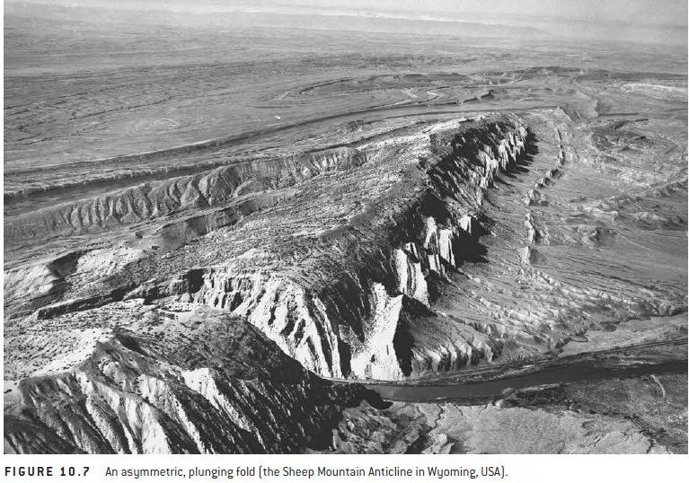
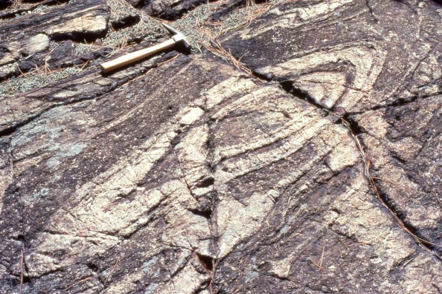
2 Fold Classification Maryland Appalachians Swiss Alps Beds in an anticline are oldest in the core; Beds in a syncline are youngest in the core; *In both cases the younging direction points (or faces) upward, EarthStructure (2 nd ed) 2

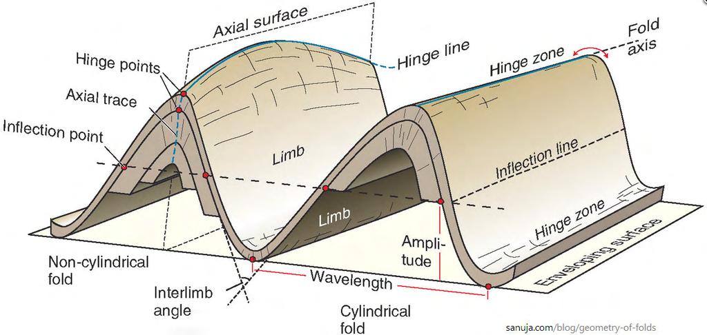
3 Anatomy of a folded surface Sec 10.2 The hinge area is the region of greatest curvature and separates the two limbs. The line of greatest curvature in a folded surface is called the hinge line. A limb is the less curved portion of a fold. In a limb there is a point where the sense of curvature changes, called the inflection point. The surface containing the hinge lines from consecutive folded surfaces in a fold is the axial surface EarthStructure (2 nd ed) 3

4 Cylindrical and non-cylindrical folds Fig A cylindrical fold is characterized by a straight hinge line and a uniformly plunging fold axis Noncylindrical folds can have planar or curved axal surfaces but have a variably plunging fold axis EarthStructure (2 nd ed) 4
5 EarthStructure (2 nd ed) 5
6 Fold geometry Fig The interlimb angle (ρ) The wavelength (L w ) The amplitude (a) The arc length (L a ) of a fold system in profile. The reference plane used to describe fold shape is called the fold profile plane, which is perpendicular to the hinge line (Figure 10.2). EarthStructure (2 nd ed) 6
7 EarthStructure (2 nd ed) 7
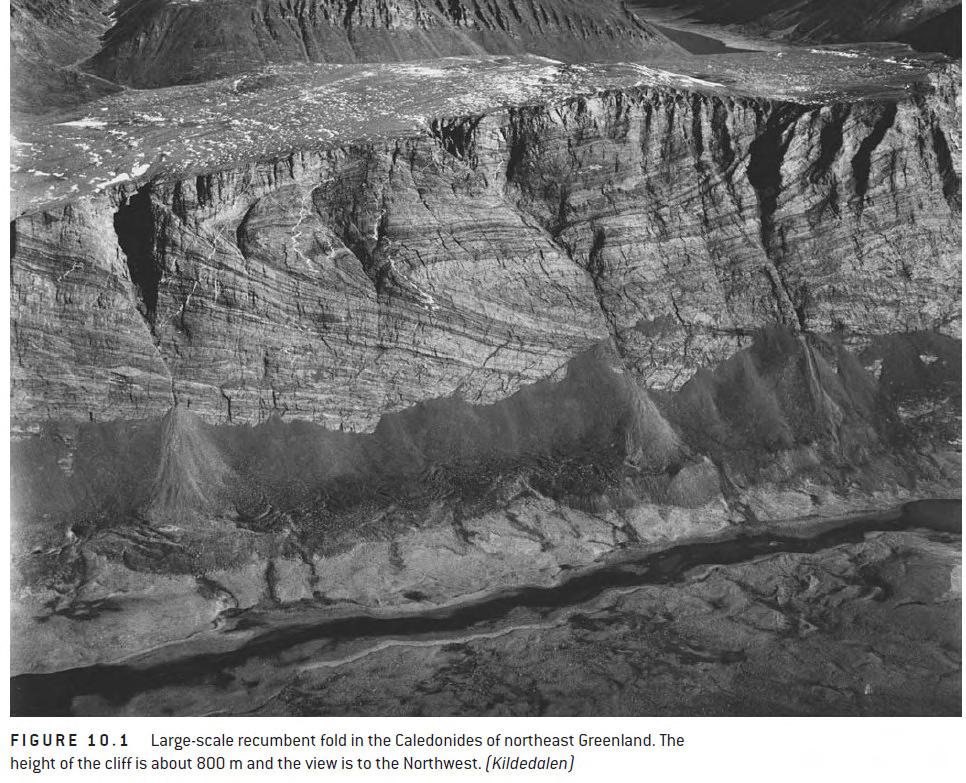
8 Fold facing upward facing antiform or anticline upward facing synform or syncline downward-facing antiform or antiformal syncline downwardfacing synform or synformal anticline Downward-facing folds reflect a complex and repeat fold history that placed the beds upside down prior to refolding. EarthStructure (2 nd ed) 8
9 Fold facing Fig The corresponding facing in map view across this area is shown in (f). Younging direction is indicated by O Y arrow. EarthStructure (2 nd ed) 9
10 Fold orientation Fig Note that the axial surface is a plane whose orientation is given by dip and strike (or dip direction), whereas the hinge line is given by plunge and bearing. EarthStructure (2 nd ed) 10
11 EarthStructure (2 nd ed) 11
12 Fold orientation Fig Fold classification based on the orientation of the hinge line and the axial surface (shaded). EarthStructure (2 nd ed) 12
13


14 Fold Shape similar fold parallel fold ptygmatic folds EarthStructure (2 nd ed) 14
 occur at the top of the thickest layer.")
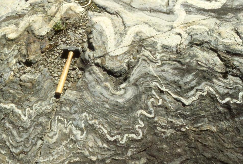
15 Harmonic and disharmonic folds Harmonic folds have approximately the same wavelength and amplitude within stacked strata Disharmonic folds have different wavelengths and/or amplitudes Note that harmonic, disharmonic, and box folding varies as a function of layer thickness and detachments (above red lines) occur at the top of the thickest layer. Small-scale folds in anhydrite of the Permian Castile Formation, TX. White layers are anhydrite; dark layers are rich in calcite and organic material EarthStructure (2 nd ed) 15

16 Fold shape Fig a Parallel fold Parallel folds maintain constant layer thickness across the fold ( t1 = t2 = t3) but the layer thickness parallel to the axial surface varies (T1 < T2 < T3). *Note that parallelism must eventually break down in the cores of folds because of space limitation, which is illustrated by the small disharmonic folds t is layer-perpendicular thickness; T is axial trace-parallel thickness EarthStructure (2 nd ed) 16
.")
17 Fold shape Fig b Similar fold In similar folds, the layer thickness parallel to the axial surface remains constant, so, T1 = T2 = T3, but the thickness across the folded surface varies (t1 > t2 > t3). Similar folds do not produce the space problem inherent in parallel folds. t is layer-perpendicular thickness; T is axial trace-parallel thickness EarthStructure (2 nd ed) 17
18 Fold classification based on dip isogons The construction of a single dip isogon is shown, which connects the tangents to the upper and lower boundary of the folded layer with equal angle (α) relative to a reference frame; EarthStructure (2 nd ed) 18
19 Fold classification based on dip isogons Fig Class 1 folds (a c) have convergent dip isogon patterns Class 2 folds (d) are parallel Class 3 folds (e) have divergent dip isogon patterns EarthStructure (2 nd ed) 19
20 EarthStructure (2 nd ed) 20

21 Enveloping surface and fold (a)symmetry Fig A series of anticlines and synclines is a fold system The fold enveloping surface. a. Symmetric; orthorhombic; ~90 o b. Asymmetric; monoclinic; < 90 o EarthStructure (2 nd ed) 21
22 Enveloping surface and fold (a)symmetry Fig The enveloping surface connects the antiform (or synform) hinges of consecutive folds (surface A). If this imaginary surface appears to be folded itself, we may construct yet a higher-order enveloping surface (surface B). Note that the orientations (hinge line and axial surface) of the small folds and the largescale folds are very similar. EarthStructure (2 nd ed) 22
23 Fold vergence Is defined by (apparent) rotation of axial surface from a Fig hypothetical symmetric fold into observed asymmetric fold, without changing orientation of enveloping surface. East-verging In a geogrpahic coordinate system we specify the vergence for clockwise and counterclockwise folds, when looking down the fold plunge. West-verging EarthStructure (2 nd ed) 23
24 Fold vergence Antiform Fig Parasitic folds across a large-scale antiform Looking down the fold axis, the parasitic fold changes from clockwise asymmetry (east-verging in the geographic coordinate system) to symmetric to counterclockwise asymmetry (west-verging) when going from W to E. EarthStructure (2 nd ed) 24
25 Fold vergence - Synform Enveloping Surface Axial Surface Parasitic folds across a large-scale synform EarthStructure (2 nd ed) 25


26 En-echelon folds Satellite view of central Appalachians Hand specimen EarthStructure (2 nd ed) 26
27 Fold Classification 1. Facing direction - upward or /downward? 2. Orientation of axis, hinge line, and axial surface, Is there symmetry and vergence? 3. Size with respect to amplitude and wavelength 4. Profile shape and interlimb angle, is it similar or parallel? 5. Is the 3D shape cylindrical or non-cylindrical and are there secondary features in the axial plane foliation or lineation? DePaor, 2002 EarthStructure (2 nd ed) 27

28 Fold Style EarthStructure (2 nd ed) 28

29 Super(im)posed folding: Fold Interference Structural geologists use the term fold generation to refer to groups of folds that formed at approximately the same time interval and under similar kinematic conditions. A fold generation in an area can be referred to using a letter label F (for Fold) and a number reflecting the relative order of their formation: F1 folds form first, followed by F2 folds, F3 folds, and so on. Several fold generations may in turn form during an orogenic phase (such as the Siluro-Devonian Acadian phase in the Appalachians or the Cretaceous-Tertiary Laramide phase in the North American Cordillera, which is noted by the letter D (for Deformation). In any mountain belt several phases may be present, which are labeled D1, D2, and so on, each containing one or more generations of folds. The relative time principle of superposed folding is simple: folds of a later generation are superimposed on folds of an earlier generation. EarthStructure (2 nd ed) 29
 are overprinted by F B upright folds producing the fold interference pattern in (c).")
30 Fold interference Fig a superposed fold must be younger than the structure it folds. F A recumbent folds (a) are overprinted by F B upright folds producing the fold interference pattern in (c). EarthStructure (2 nd ed) 30

31 Four basic patterns of fold interference Fig The analysis assumes that F2 shear folds are superimposed on a preexisting F1 fold of variable orientation. The shaded surface is the S1 axial surface. a 2 is the relative shear direction and b 2 is the hinge line Type 1 Shear folds are modeled by moving a deck of cards. EarthStructure (2 nd ed) 31
")
32 Four basic patterns of fold interference Fig Type 2 Type 3 EarthStructure (2 nd ed) 32
33 Fold interference scheme Fig Geometric axes are used to describe the orientation of fold generations F1 and F2 that produce a wide range of intererence patterns when combined at carious angles: EarthStructure (2 nd ed) 33
34 Fold interference scheme Fig In all patterns, layering was initially parallel to front face of cube. F1 resembles case D; F2 is similar to the folding in case D, but with different orientations. Axial surface S1 is shown with dotted lines and axial surface S2 with dashed lines. EarthStructure (2 nd ed) 34

35 The Mechanics of Folding Sec.10.7 Passive Folding Elevated temperatures can produce the right conditions for passive folding and it is common to find toothpaste-like structures in deformed metamorphic rocks. Rocks that were deformed at or near their melting temperature have little or no competency contrast between layers and can form migmatites, which often contain wonderfully complex fold structures Similarly, passive folding occurs in glaciers that deform close to their melting temperature EarthStructure (2 nd ed) 35

36 The Mechanics of Folding Fig Passive Folding Compression of a clay block of uniform color with irregularly shaped layers of different colors or with uniform colored layers separated by thin sheets of rubber EarthStructure (2 nd ed) 36
37 The Mechanics of Folding Sec.10.7 Active Folding During active folding, also called flexural folding, the layering has mechanical significance. There are two dynamic conditions for active folding: bending and buckling. In nature bending occurs during basin formation or flexural loading of a lithospheric plate, or during the development of monoclines over fault blocks. In bending, the applied force is oriented at an oblique angle to the layering In buckling, the force is oriented parallel to the mechanical anisotropy and is the most common EarthStructure (2 nd ed) 37
, a thin, a medium, and a thick rubber band.")
38 The Mechanics of Folding Sec.10.7 Buckle-fold experiments Line drawings of deformation experiments with transparent boxes containing foam, and rubber bands. Four starting settings are shown that contain, from left to right, foam only (with marker line added), a thin, a medium, and a thick rubber band. When applying the same displacement (b), the setups respond differently. The foam-only box shows thickening of the marker line, but no folding. The boxes with rubber bands show folds with arc lengths varying as a function of thickness of each band. When using more than one band (c), the behavior depends on the combination of bands and their thicknesses, with the effect of the thicker bands being dominant. EarthStructure (2 nd ed) 38
39 Viscosity contrast Fig Finite-element modeling buckling for various viscosity contrasts between layer (η L ) and matrix (η M ), and shortening strains (%). Short marks are long axis of strain ellipse. EarthStructure (2 nd ed) 39

40 Flexural-slip fold model includes slip between layers Sec The amount of slip between the layers increases away from the hinge zone and reaches a maximum at the inflection point. The amount of slip is proportional to limb dip: slip increases with increasing dip. A geometric consequence of the flexural slip model is that the fold is cylindrical and parallel (Class 1B); the bed thickness in flexural slip folds does not change. Chevron and kink folds are examples of flexural slip folding in natural rocks that form because of a strong layer anisotropy. EarthStructure (2 nd ed) 40

")

41 Fold geometries: kink and chevron folds Kink fold (Spain) Recumbent chevron (Switzerland) Chevron folds CA) EarthStructure (2 nd ed) 41

42 Flexural-flow fold model includes grain slip Sec Slip that occurs on individual grains within a layer, without the presence of visible slip surfaces, we call flexural flow folding. Although they differ in a few details, the geometric and kinematic consequences of both flexural slip and flexural flow folding are alike. A diagnostic feature of flexural slip folding that can be used in field analysis is that any original angular relationship in the slip surface before folding (say, flute casts in the bedding surfaces of turbidites) will maintain this angular relationship across the fold, because there is no strain on the top and bottom of the folded surface. EarthStructure (2 nd ed) 42
43 Neutral-surface fold model also results in parallel folds A neutral-surface fold is a parallel fold having a zero-strain surface EarthStructure (2 nd ed) 43
44 Shear fold model Sec Shear folds are passive features. While slip occurs on individual cards, the slip surface and the slip vector are not parallel to the folded surface, as they are with flexural folding. Most notably, shear folds have a distinct, similarfold (Class 2) shape with the layer on each card remaining equal in length after shearing. EarthStructure (2 nd ed) 44
45 Natural settings produce nested folds of different Classes In all models, Class 3 folds are unaccounted for, which brings us to natural systems in which Class 3 folds form from the interaction between layers of different competency in a multilayered system. Folding of a multilayer consisting of sandstone(stippled) and shale layers. The incompetent shale layers accommodate the strong sandstone layers that form Class 1 folds This results in Class 3 and Class 2 folds in shale when the sandstone layers are closely and more widely spaced, respectively. EarthStructure (2 nd ed) 45
46 Fault-related Folds fault-propagation fold EarthStructure (2nd ed) 46
47 Fault-related Folds fault-bend fold EarthStructure (2 nd ed) 47


48 Fault-bend fold Fig Progressive stages during development of fault-bend fold. Photo of fault-bend fold above McConnell Thrust, Alberta. Paleozoic strata moved 5 km vertically and 40 km horizontally, and now lie above Cretaceous foreland basin deposits. (mirror image) EarthStructure (2 nd ed) 48


49 Fault-propagation fold Fig Progressive stages during development of fault-propagation fold. Exposure of a fold in the Lost River Range, Idaho, showing an asymmetric fold dying out updip in the core of a fold. EarthStructure (2 nd ed) 49

50 Fault-related Folds EarthStructure (2 nd ed) 50
")
51 Fault-related Folding EarthStructure (2 nd ed) 51
52 Transposition Sheath fold EarthStructure (2 nd ed) 52
, which in turn gets refolded (e f).")
53 Fold transposition Asymmetric fold develops at a perturbation (a d), which in turn gets refolded (e f). EarthStructure (2 nd ed) 53
Folds and Folding. Processes in Structural Geology & Tectonics. Ben van der Pluijm. WW Norton+Authors, unless noted otherwise 3/4/ :15
 Folds and Folding Processes in Structural Geology & Tectonics Ben van der Pluijm WW Norton+Authors, unless noted otherwise 3/4/2017 17:15 We Discuss Folds and Folding Fold Description Fold Classification
Geology for Engineers Rock Mechanics and Deformation of Earth Materials
 89.325 Geology for Engineers Rock Mechanics and Deformation of Earth Materials Why do rocks break? Rock mechanics experiments a first order understanding. Faults and Fractures Triaxial load machine. a)
Folds in Appalachian Mts.
 Pelatnas IESO Geologi Struktur 2013 Deformasi Liat Salahuddin Husein Jurusan Teknik Geologi Fakultas Teknik Universitas Gadjah Mada 2013 1 Folds in Appalachian Mts. Folds in Myanmar, in the Indo-Burma
Lecture 6 Folds, Faults and Deformation Dr. Shwan Omar
 Fold: A fold is a bend or wrinkle of rock layers or foliation; folds form as a sequence of ductile deformation. Folding is the processes by which crustal forces deform an area of crust so that layers of
Lab 7: STRUCTURAL GEOLOGY FOLDS AND FAULTS
 Lab 7: STRUCTURAL GEOLOGY FOLDS AND FAULTS This set of labs will focus on the structures that result from deformation in earth s crust, namely folds and faults. By the end of these labs you should be able
Provided by Tasa Graphic Arts, Inc. for An Introduction to Structural Methods DVD-ROM
 Provided by Tasa Graphic Arts, Inc. for An Introduction to Structural Methods DVD-ROM http://www.tasagraphicarts.com/progstruct.html AN INTRODUCTION TO STRUCTURAL METHODS - DETAILED CONTENTS: (Navigate
FOLD CLASSIFICATIONS
 GG303 Lecture 28 9/4/01 1 FOLD CLASSIFICATIONS I Main Topics A Fold nomenclature B Ramsay's classification schemes C Interference of folds D Superposition of folds II Fold nomenclature and classification
Name. GEOL.5220 Structural Geology Faults, Folds, Outcrop Patterns and Geologic Maps. I. Properties of Earth Materials
 I. Properties of Earth Materials GEOL.5220 Structural Geology Faults, Folds, Outcrop Patterns and Geologic Maps Name When rocks are subjected to differential stress the resulting build-up in strain can
Chapter 15 Structures
 Chapter 15 Structures Plummer/McGeary/Carlson (c) The McGraw-Hill Companies, Inc. TECTONIC FORCES AT WORK Stress & Strain Stress Strain Compressive stress Shortening strain Tensional stress stretching
Exam Deformatie en Metamorfose van de Korst Educatorium zaal ALFA
 Naam Studentnummer... Exam Deformatie en Metamorfose van de Korst Educatorium zaal ALFA Do not forget to put your name and student number on each of the question and answer sheets and to return both of
1. classic definition = study of deformed rocks in the upper crust
 Structural Geology I. Introduction 1. classic definition = study of deformed rocks in the upper crust deformed includes translation, rotation, and strain (change of shape) All rocks are deformed in some
Geologic Structures. Changes in the shape and/or orientation of rocks in response to applied stress
 Geologic Structures Changes in the shape and/or orientation of rocks in response to applied stress Figure 15.19 Can be as big as a breadbox Or much bigger than a breadbox Three basic types Fractures >>>
CHAPTER Va : CONTINUOUS HETEROGENEOUS DEFORMATION
 Va-1 INTRODUCTION Heterogeneous deformation results from mechanical instabilities (folding and boudinage) within an heterogeneous material or from strain localization in an homogeneous material (shear
What Causes Rock to Deform?
 Crustal Deformation Earth, Chapter 10 Chapter 10 Crustal Deformation What Causes Rock to Deform? Deformation is a general term that refers to all changes in the shape or position of a rock body in response
Strike-Slip Faults. ! Fault motion is parallel to the strike of the fault.
 Strike-Slip Faults! Fault motion is parallel to the strike of the fault.! Usually vertical, no hanging-wall/footwall blocks.! Classified by the relative sense of motion. " Right lateral opposite block
Crustal Deformation Earth - Chapter Pearson Education, Inc.
 Crustal Deformation Earth - Chapter 10 Structural Geology Structural geologists study the architecture and processes responsible for deformation of Earth s crust. A working knowledge of rock structures
Crustal Deformation. (Building Earth s Surface, Part 1) Science 330 Summer Mapping geologic structures
 Science 330 Summer Mapping geologic structures") Crustal Deformation (Building Earth s Surface, Part 1) Science 330 Summer 2005 Mapping geologic structures When conducting a study of a region, a geologist identifies and describes the dominant rock structures
Crustal Deformation (Building Earth s Surface, Part 1) Science 330 Summer 2005 Mapping geologic structures When conducting a study of a region, a geologist identifies and describes the dominant rock structures
CRUSTAL DEFORMATION. Chapter 10
 CRUSTAL DEFORMATION and dgeologic Structures t Chapter 10 Deformation Df Deformation involves: Stress the amount of force applied to a given area. Types of Stress: Confining Stress stress applied equally
FOLDS fold fold trains fold belt Folded single surface - basic geometrical definitions hinge limbs hinge line fold axis
 207 FOLDS The term fold is used when one or stacks of originally flat and planar surfaces such as sedimentary beds become bent or curved as a result of plastic (i.e. permanent) and ductile deformation.
Answer sheet for question 1 Answer question 1 as soon as the sample arrives at your desk.
 EAS 233 Geologic structures. Final test. April 2012. 3 hours. Answer question 1 and 2 and three other questions. If you start more than the required number of questions, clearly delete the answers you
UNIT 10 MOUNTAIN BUILDING AND EVOLUTION OF CONTINENTS
 UNIT 10 MOUNTAIN BUILDING AND EVOLUTION OF CONTINENTS ROCK DEFORMATION Tectonic forces exert different types of stress on rocks in different geologic environments. STRESS The first, called confining stress
Lecture 15. Fold-Thrust Belts, and the NJ Ridge and Valley Thrust System
 Lecture 15 Fold-Thrust Belts, and the NJ Ridge and Valley Thrust System Earth Structure (2 nd Edition), 2004 W.W. Norton & Co, New York Slide show by Ben van der Pluijm WW Norton; unless noted otherwise
Team Name. Name(s) SSSS Unome Geologic Mapping Test Packet p1
 SSSS Unome Geologic Mapping Test Packet p1") Scioly Summer Study Session 2018-2019 Geologic Mapping Test Packet Written by Unome Instructions 1) This test is based on the 2016 rules for Geologic Mapping. 2) This test is out of 115 points. Questions
Scioly Summer Study Session 2018-2019 Geologic Mapping Test Packet Written by Unome Instructions 1) This test is based on the 2016 rules for Geologic Mapping. 2) This test is out of 115 points. Questions
KEY CHAPTER 12 TAKE-HOME QUIZ INTERNAL STRUCTURES AND PROCESSES Score Part B = / 55 PART B
 GEOLOGY 12 KEY CHAPTER 12 TAKE-HOME QUIZ INTERNAL STRUCTURES AND PROCESSES Score Part B = / 55 PART B CHAPTER 12 Isostacy and Structural Geology 1. Using the terms below, label the following diagrams and
Lab 6: Plate tectonics, structural geology and geologic maps
 Geology 103 Name(s): Lab 6: Plate tectonics, structural geology and geologic maps Objective: To show the effects of plate tectonics on a large-scale set of rocks and to reconstruct the geological history
Answers: Internal Processes and Structures (Isostasy)
") Answers: Internal Processes and Structures (Isostasy) 1. Analyse the adjustment of the crust to changes in loads associated with volcanism, mountain building, erosion, and glaciation by using the concept
Answers: Internal Processes and Structures (Isostasy) 1. Analyse the adjustment of the crust to changes in loads associated with volcanism, mountain building, erosion, and glaciation by using the concept
Staple this part to part one of lab 6 and turn in. Lab 6, part two: Structural geology (analysis)
") Geology 101 Staple this part to part one of lab 6 and turn in Lab 6, part two: Structural geology (analysis) Recall that the objective of this lab is to describe the geologic structures of Cougar Mountain
Geology 101 Staple this part to part one of lab 6 and turn in Lab 6, part two: Structural geology (analysis) Recall that the objective of this lab is to describe the geologic structures of Cougar Mountain
shear zones Ductile shear zones can develop as a results of shearing (simple shear strain) or "squeezing" (pure shear strain).
 or squeezing (pure shear strain).") shear zones Ductile shear zones can develop as a results of shearing (simple shear strain) or "squeezing" (pure shear strain). Shear Zones Mylonite, or mylonitic zone is the central part of the shear zone
shear zones Ductile shear zones can develop as a results of shearing (simple shear strain) or "squeezing" (pure shear strain). Shear Zones Mylonite, or mylonitic zone is the central part of the shear zone
Stress and Strain. Stress is a force per unit area. Strain is a change in size or shape in response to stress
 Geologic Structures Geologic structures are dynamically-produced patterns or arrangements of rock or sediment that result from, and give information about, forces within the Earth Produced as rocks change
Study the architecture and processes responsible for deformation of Earth s crust. Folding and Faulting
 Crustal Deformation AKA Structural geology (adapted from Brunkel, 2012) Study the architecture and processes responsible for deformation of Earth s crust. Folding and Faulting How Rocks Deform: 4 Controls
Lecture 9 faults, folds and mountain building
 Lecture 9 faults, folds and mountain building Rock deformation Deformation = all changes in size, shape, orientation, or position of a rock mass Structural geology is the study of rock deformation Deformation
Mountains are then built by deforming crust: Deformation & Mountain Building. Mountains form where stresses are high!
 Deformation & Mountain Building Where are mountains located? Deformation and Folding Mountain building Mountains form where stresses are high! Mountains form at all three types of plate boundaries where
Tectonics is a study of the major structural features of the Earth s crust or a broad structure of a region. Tecto- means building
 TECTONICS AND TECTONIC STRUCTURES Tectonics is a study of the major structural features of the Earth s crust or a broad structure of a region. Tecto- means building The plate theory Different stages are
GEOL372: Week 5 Thrust fault systems. Contractional regimes
 4/3/15 GEOL372: Week 5 Thrust fault systems Contractional regimes Thrust faulting accommodates shortening σ3 σ1 1 Thrust geometry Thrust geometry RAMP segment of fault with different strike and/or dip
UNIVERSITY OF PRETORIA Department of Geology STRUCTURAL GEOLOGY -GLY 254 SEMESTER EXAM
 UNIVERSITY OF PRETORIA Department of Geology STRUCTURAL GEOLOGY -GLY 254 SEMESTER EXAM Copyright reserved 6 th June 2006 Time: 3 hours Internal examiner: Dr A.J. Bumby External examiner: Dr R. van der
Structural Geology Folding
 Structural Geology Folding Folding pieces of felt A P 10 min Provide students with 3 pieces of felt of different colours each 10cm by 60cm. Each colour represents a different type of strata. The felt pieces
Deformation and Strain
 Deformation and Strain Processes in Structural Geology & Tectonics Ben van der Pluijm WW Norton+Authors, unless noted otherwise 2/13/2017 15:13 We Discuss Deformation and Strain Deformation Components
FOLDING. Folding jpb, 2017
 177 FOLDING Folding is a concept that embraces all geologic processes by which surfaces in rocks become curved during deformation. Since folds are permanent deformation structures with no or little loss
Part I. PRELAB SECTION To be completed before labs starts:
 Student Name: Physical Geology 101 Laboratory #13 Structural Geology II Drawing and Analyzing Folds and Faults Grade: Introduction & Purpose: Structural geology is the study of how geologic rock units
Question 1: Examine the following diagram:
 Question 1: Examine the following diagram: 1a.) Which of the illustrated faults is a left-handed strike-slip fault? = a 1b.) Which of the illustrated faults is a normal-slip fault? = e 1c.) Which of the
Deformation of Rocks. Orientation of Deformed Rocks
 Deformation of Rocks Folds and faults are geologic structures caused by deformation. Structural geology is the study of the deformation of rocks and its effects. Fig. 7.1 Orientation of Deformed Rocks
GCE AS/A level 1211/01 GEOLOGY GL1 Foundation Unit
 Surname Centre Number Candidate Number Other Names 2 GCE AS/A level 1211/01 GEOLOGY GL1 Foundation Unit S15-1211-01 A.M. MONDAY, 11 May 2015 1 hour For s use Question Maximum Mark 1. 15 2. 14 Mark Awarded
Unit 4 Lesson 3 Mountain Building. Copyright Houghton Mifflin Harcourt Publishing Company
 Stressed Out How can tectonic plate motion cause deformation? The movement of tectonic plates causes stress on rock structures. Stress is the amount of force per unit area that is placed on an object.
Crustal Deformation. Earth Systems 3209
 Crustal Deformation Earth Systems 3209 Crustal Deformation pg. 415 Refers to all changes in the original form and/or size of a rock body. May also produce changes in the location and orientation of rocks.
How mountains are made. We will talk about valleys (erosion and weathering later)
") How mountains are made We will talk about valleys (erosion and weathering later) http://www.ilike2learn.com/ilike2learn/mountainmaps/mountainranges.html Continent-continent plate convergence Less dense,
How mountains are made We will talk about valleys (erosion and weathering later) http://www.ilike2learn.com/ilike2learn/mountainmaps/mountainranges.html Continent-continent plate convergence Less dense,
Brittle Deformation. Earth Structure (2 nd Edition), 2004 W.W. Norton & Co, New York Slide show by Ben van der Pluijm
, 2004 W.W. Norton & Co, New York Slide show by Ben van der Pluijm") Lecture 6 Brittle Deformation Earth Structure (2 nd Edition), 2004 W.W. Norton & Co, New York Slide show by Ben van der Pluijm WW Norton, unless noted otherwise Brittle deformation EarthStructure (2 nd
Lecture 6 Brittle Deformation Earth Structure (2 nd Edition), 2004 W.W. Norton & Co, New York Slide show by Ben van der Pluijm WW Norton, unless noted otherwise Brittle deformation EarthStructure (2 nd
Lecture Outline Friday March 2 thru Wednesday March 7, 2018
 Lecture Outline Friday March 2 thru Wednesday March 7, 2018 Questions? Lecture Exam Friday March 9, 2018 Same time, Same room Bring Pencils and WSU ID 50 question Multiple Choice, Computer Graded Interlude
GEOL 321 Structural Geology and Tectonics
 GEOL 321 Structural Geology and Tectonics Geology 321 Structure and Tectonics will be given in Spring 2017. The course provides a general coverage of the structures produced by brittle and ductile rock
Faults, folds and mountain building
 Faults, folds and mountain building Mountain belts Deformation Orogens (Oro = Greek all changes for mountain, in size, shape, genesis orientation, = Greek for or formation) position of a rock mass Structural
Lab 8: Folds and their map patterns
 Lab 8: Fols an their map patterns Fall 2005 1 Fols are one of the most common tectonic structures evelope in eforme rocks. They form in rocks containing planar features such as seimentary being, lithologic
Structural Geology and Geology Maps Lab
 Structural Geology and Geology Maps Lab Mesa College Geology 101 Lab Ray Rector: Instructor Structural Geology Lab Pre-Lab Resources Pre-Lab Internet Links 1) Fundamentals of Structural Geology 2) Visualizing
Contractional Tectonics: Convergence and Collision
 Contractional Tectonics: Convergence and Collision Processes in Structural Geology & Tectonics Ben van der Pluijm WW Norton+Authors, unless noted otherwise 4/12/2017 5:21 PM We Discuss Contractional Tectonics
Structural Geology Lab. The Objectives are to gain experience
 Geology 2 Structural Geology Lab The Objectives are to gain experience 1. Drawing cross sections from information given on geologic maps. 2. Recognizing folds and naming their parts on stereoscopic air
Location and Distance on Earth (Chapter 22 part 1)
") GEOLOGY 306 Laboratory Instructor: TERRY J. BOROUGHS NAME: Location and Distance on Earth (Chapter 22 part 1) For this assignment you will require: a calculator, protractor, and a metric ruler, and an
GEOLOGY 306 Laboratory Instructor: TERRY J. BOROUGHS NAME: Location and Distance on Earth (Chapter 22 part 1) For this assignment you will require: a calculator, protractor, and a metric ruler, and an
STRUCTURAL ANALYSIS. Structural analysis jpb, 2017
 STRUCTURAL ANALYSIS 269 Structural geology uses micro- and meso-scale structures found in the rocks to elaborate tools and methods enabling to identify structures too large to be directly observed, although
A CROSS-SECTION the internal shape of folds. This is what you would see in a roadcut or a canyon wall. It is a view from the side.
 FOLDS Basic Fold Geometry A CROSS-SECTION the internal shape of folds. This is what you would see in a roadcut or a canyon wall. It is a view from the side. Closer to Earth s surface Deeper in Earth HINGE
How to Build a Mountain and other Geologic Structures. But first a short review
 How to Build a Mountain and other Geologic Structures But first a short review Where do we see deep earthquakes? What is happening there? What can happen at a plate boundary? 1. Plates can move apart
FOLDS ABOVE ANGULAR FAULT BENDS: MECHANICAL CONSTRAINTS FOR BACKLIMB TRISHEAR KINEMATIC MODELS. A Thesis LI ZHANG
 FOLDS ABOVE ANGULAR FAULT BENDS: MECHANICAL CONSTRAINTS FOR BACKLIMB TRISHEAR KINEMATIC MODELS A Thesis by LI ZHANG Submitted to the Office of Graduate Studies of Texas A&M University in partial fulfillment
Structural Geology of the Mountains
 Structural Geology of the Mountains Clinton R. Tippett Shell Canada Limited, Calgary, Alberta clinton.tippett@shell.ca INTRODUCTION The Southern Rocky Mountains of Canada (Figure 1) are made up of several
Using An Introduction to Structural Methods - An Interactive CD-ROM - In and Out of the Classroom
 Using An to Structural Methods - An Interactive CD-ROM - In and Out of the Classroom Tekla A. Harms, Amherst College taharms@amherst.edu H. Robert Burger, Smith College rburger@email.smith.edu TYPE OF
How to Build a Mountain and other Geologic Structures. But first, questions
 How to Build a Mountain and other Geologic Structures But first, questions Questions your students might ask How were Montana s mountains formed? How old are the mountains? What are the different ways
Lecture 7. Joints and Veins. Earth Structure (2 nd Edition), 2004 W.W. Norton & Co, New York Slide show by Ben van der Pluijm
, 2004 W.W. Norton & Co, New York Slide show by Ben van der Pluijm") Lecture 7 Joints and Veins Earth Structure (2 nd Edition), 2004 W.W. Norton & Co, New York Slide show by Ben van der Pluijm WW Norton; unless noted otherwise Joints Three sets of systematic joints controlling
Lecture 7 Joints and Veins Earth Structure (2 nd Edition), 2004 W.W. Norton & Co, New York Slide show by Ben van der Pluijm WW Norton; unless noted otherwise Joints Three sets of systematic joints controlling
Learning Objectives (LO) What we ll learn today:!
 What we ll learn today:!") Learning Objectives (LO) Lecture 13: Mountain Building Read: Chapter 10 Homework #11 due Tuesday 12pm What we ll learn today:! 1. Define the types of stress that are present in the crust! 2. Define the
Learning Objectives (LO) Lecture 13: Mountain Building Read: Chapter 10 Homework #11 due Tuesday 12pm What we ll learn today:! 1. Define the types of stress that are present in the crust! 2. Define the
GEOLOGIC MAPS PART II
 EARTH AND ENVIRONMENT THROUGH TIME LABORATORY - EES 1005 LABORATORY FIVE GEOLOGIC MAPS PART II Introduction Geologic maps of orogenic belts are much more complex than maps of the stable interior. Just
Unit 4 Lesson 7 Mountain Building
 Indiana Standards 7.2.4 Explain how convection currents in the mantle cause lithospheric plates to move causing fast changes like earthquakes and volcanic eruptions, and slow changes like creation of mountains
4 Deforming the Earth s Crust
 CHAPTER 7 4 Deforming the Earth s Crust SECTION Plate Tectonics BEFORE YOU READ After you read this section, you should be able to answer these questions: What happens when rock is placed under stress?
Geologic Mapping Invitational Trial Event
 Geologic Mapping Invitational Trial Event A TEAM OF UP TO: 2 Team Name AVAILABLE TIME: 50 min Required Materials: Each team MUST have a protractor, ruler, non-programmable calculator, colored pencils,
Interactive 3D Sketchupbook
 THE UNIVERSITY OF SYDNEY - SCHOOL OF GEOSCIENCES Interactive 3D Sketchupbook Patrice F. Rey CHAPTER 1 Orienting Planes and Lines 1 Interactive 1.1 Strike, dip and dip direction In a 3D space, planar surfaces
Exam in : GEO-3104 Advanced Structural. Geology. Date : Time : Approved remedies : Ruler (linjal), Compasses (passer),
, Compasses (passer),") Page 1 of 5 pages FINAL EXAM IN GEO-3104 Exam in : GEO-3104 Advanced Structural Geology Date : 28-02-2013 Time : 9.00 12.00 Place : Aud.Max. Approved remedies : Ruler (linjal), Compasses (passer), Protractor
Page 1 of 5 pages FINAL EXAM IN GEO-3104 Exam in : GEO-3104 Advanced Structural Geology Date : 28-02-2013 Time : 9.00 12.00 Place : Aud.Max. Approved remedies : Ruler (linjal), Compasses (passer), Protractor
December 21, Chapter 11 mountain building E.notebook. Feb 19 8:19 AM. Feb 19 9:28 AM
 Mountains form along convergent plate boundaries. Typically (usually) if you look at a mountain range, you know that it is at a plate boundary (active continental margin) or has been some time in the past
Structural Geology, GEOL 330 Fold mapping lab: Even folds get parasites Spring, 2012
 Structural Geology, GEOL 330 Name: Fold mapping lab: Even folds get parasites Spring, 2012 This exercise is meant to mimic a field experience in which you, the student, will measure beddingcleavage relationships
Lecture 5. Rheology. Earth Structure (2 nd Edition), 2004 W.W. Norton & Co, New York Slide show by Ben van der Pluijm
, 2004 W.W. Norton & Co, New York Slide show by Ben van der Pluijm") Lecture 5 Rheology Earth Structure (2 nd Edition), 2004 W.W. Norton & Co, New York Slide show by Ben van der Pluijm WW Norton; unless noted otherwise Rheology is... the study of deformation and flow of
Lecture 5 Rheology Earth Structure (2 nd Edition), 2004 W.W. Norton & Co, New York Slide show by Ben van der Pluijm WW Norton; unless noted otherwise Rheology is... the study of deformation and flow of
Folding/Faulting: Topographic Expression of Folded Strata
 Folding/Faulting: Topographic Expression of Folded Strata Mountains: Orogenesis and Deformation Folding Faulting Joints & Fractures Domes and Basins Horst and Graben Rift Valleys US Examples: Sierra Nevada
Essentials of Geology, 11e
 Essentials of Geology, 11e Crustal Deformation and Mountain Building Chapter 17 Instructor Jennifer Barson Spokane Falls Community College Geology 101 Stanley Hatfield Southwestern Illinois College Jennifer
Course Title: Discipline: Geology Level: Basic-Intermediate Duration: 5 Days Instructor: Prof. Charles Kluth. About the course: Audience: Agenda:
 Course Title: Structural Geology Discipline: Geology Level: Basic-Intermediate Duration: 5 Days Instructor: Prof. Charles Kluth About the course: This course covers the basic ideas of structural geometry
Theme 7. Metamorphic rocks. Distinguishing rock types
 Theme 7. Metamorphic rocks. Distinguishing rock types 7.1. Metamorphic rocks formation 7.2. Classification of metamorphic rocks 7.3. Distinguishing rock types 7.1. Metamorphic rocks formation 7.1. Metamorphic
Description of faults
 GLG310 Structural Geology Description of faults Horizontal stretch Crustal thickness Regional elevation Regional character Issues Normal Thrust/reverse Strike-slip >1 1 in one direction and < 1 in
A. Refer to Appendix F in back of lab manual for list of commonly used geologic map symbols
 Structural Geology Lab 2: Outcrop Patterns and Structure Contours I. Geologic Map Symbols A. Refer to Appendix F in back of lab manual for list of commonly used geologic map symbols 1. Emphasis: a. strike
LAB 1: ORIENTATION OF LINES AND PLANES
 LAB 1: ORIENTATION OF LINES AND PLANES Read the introductory section, chapter 1, pages 1-3, of the manual by Rowland et al (2007) and make sure you understand the concepts of bearing, strike, dip, trend,
EAS FINAL EXAM
 EAS 326-03 FINAL EXAM This exam is closed book and closed notes. It is worth 150 points; the value of each question is shown at the end of each question. At the end of the exam, you will find two pages
Chapter 10: Deformation and Mountain Building. Fig. 10.1
 Chapter 10: Deformation and Mountain Building Fig. 10.1 OBJECTIVES Describe the processes of rock deformation and compare and contrast ductile and brittle behavior in rocks. Explain how strike and dip
GY111 Earth Materials Practice Final Exam
 I. True/False Questions: circle a T for true or F for false (10% total -or- 0.5 per) 1. (T F) The Uranium used in nuclear power plants may explode if not controlled properly. 2. (T F) Natural Gas is an
NAME HOMEWORK ASSIGNMENT #3 MATERIAL COVERS CHAPTERS 8, 9, 10, 11
 NAME HOMEWORK ASSIGNMENT #3 MATERIAL OVERS HAPTERS 8, 9, 10, 11 Assignment is due the beginning of the class period on November 23, 2004. Answers for each chapter will be discussed in class, as Exam #3
GCE A level 1214/01 GEOLOGY GL4 Interpreting the Geological Record
 Surname Centre Number Candidate Number Other Names 2 GCE A level 1214/01 GEOLOGY GL4 Interpreting the Geological Record P.M. MONDAY, 6 June 2016 2 hours S16-1214-01 For s use Question Maximum Mark Mark
4 Deforming the Earth s Crust
 CHAPTER 7 4 Deforming the Earth s Crust SECTION Plate Tectonics BEFORE YOU READ After you read this section, you should be able to answer these questions: What happens when rock is placed under stress?
lecture 7 Foliations & lineations
 Kristallingeologie lecture 7 Foliations & lineations 28 participants Results test A, 2008 Maximum 70 points Pass!35 points (!50%) Best result 67 points Average result 54 points ("2.3) Worst result 30 points
A.M. TUESDAY, 12 May hours
 Candidate Name Centre Number 2 Candidate Number GCE AS/A level 1212/01 New AS GEOLOGY - GL2a Investigative Geology A.M. TUESDAY, 12 May 2009 1 1 2 hours For Examiner s Use Only ADDITIONAL MATERIALS In
N30 E-45 SE S25 E-10 SW N85 W-80 NE
 Geologic aps and tructures Name Geology 100 Harbor section Read h. 7 before you begin. The objectives of this lab are for you to learn the basic geologic structures in 3- and to develop some facility in
In this lab, we will study and analyze geologic maps from a few regions, including the Grand Canyon, western Wyoming, and coastal California.
 Name: Lab Section: work in groups, but each person turns in his/her own GEOSCIENCE 001 LAB UNDERSTANDING GEOLOGIC MAPS Geologic maps are colorful and even beautiful, but they also contain an amazing amount
Earth Science, (Tarbuck/Lutgens) Chapter 10: Mountain Building
 Chapter 10: Mountain Building") Earth Science, (Tarbuck/Lutgens) Chapter 10: Mountain Building 1) A(n) fault has little or no vertical movements of the two blocks. A) stick slip B) oblique slip C) strike slip D) dip slip 2) In a(n) fault,
Earth Science, (Tarbuck/Lutgens) Chapter 10: Mountain Building 1) A(n) fault has little or no vertical movements of the two blocks. A) stick slip B) oblique slip C) strike slip D) dip slip 2) In a(n) fault,
Convergent plate boundary.
 Crustal Deformation Convergent plate boundary http://my.execpc.com/~acmelasr/mountains/geogramsnf.html Plate Tectonic Settings and Magma Where plates CONVERGE, water is driven off the subducting plate,
Forces in Earth s Crust
 Forces in Earth s Crust This section explains how stresses in Earth s crust cause breaks, or faults, in the crust. The section also explains how faults and folds in Earth s crust form mountains. Use Target
Chapter. Mountain Building
 Chapter Mountain Building 11.1 Rock Deformation Factors Affecting Deformation Factors that influence the strength of a rock and how it will deform include temperature, confining pressure, rock type, and
Lecture Outlines PowerPoint. Chapter 10 Earth Science, 12e Tarbuck/Lutgens
 Lecture Outlines PowerPoint Chapter 10 Earth Science, 12e Tarbuck/Lutgens 2009 Pearson Prentice Hall This work is protected by United States copyright laws and is provided solely for the use of instructors
You must take the exam in the lecture section for which you are registered. Any exceptions must be cleared with the instructor in advance.
 Geo 101, Fall 2000 Review Questions for Final Exam GEOLOGIC TIME AND FOLDING AND FAULTING THE FINAL EXAM FOR MWF CLASS WILL BE TUESDAY 1400 THE FINAL EXAM FOR TR CLASS WILL BE FRIDAY 930 These questions
(1) Identify 5 major principles of relative dating? For each principle, describe how you tell what is younger and what is older.
 Identify 5 major principles of relative dating? For each principle, describe how you tell what is younger and what is older.") Things to Know - Third GLG101Exam Page 1 Important Note: This is not everything you need to know or study. However, it provides you with a relatively comprehensive list of questions to help you study.
Things to Know - Third GLG101Exam Page 1 Important Note: This is not everything you need to know or study. However, it provides you with a relatively comprehensive list of questions to help you study.
Geology Wilson Computer lab Pitfalls II
 Geology 554 - Wilson Computer lab Pitfalls II Today we ll explore a subtle pitfall that can have significant influence on the interpretation of both simple and complex structures alike (see example 10
GEOL 02: Historical Geology Lab 14: Topographic Maps. Name: Date:
 GEOL 02: Historical Geology Lab 14: Topographic Maps Name: Date: A topographic map is a two dimensional (flat) representation (model) of a three dimensional land surface (landscape). It shows landforms
Crags, Cracks, and Crumples: Crustal Deformation and Mountain Building
 Crags, Cracks, and Crumples: Crustal Deformation and Mountain Building Updated by: Rick Oches, Professor of Geology & Environmental Sciences Bentley University Waltham, Massachusetts Based on slides prepared
Dip-Sequence Analysis
 Chapter 9 Dip-Sequence Analysis 9.1 Introduction The three-dimensional geometry of a structure can be determined from the bedding attitudes measured in a single well bore or on a traverse through a structure.