Prepare by: Pars Geological Research Center (Arian Zamin) August 2012
|
|
|
- Crystal Ferguson
- 5 years ago
- Views:
Transcription
")
1 Prepare by: Pars Geological Research Center (Arian Zamin) August 2012
2 Position, boundaries and area of Iran Iran is located in southwest of the Continent of Asia like a bridge connecting three continents of Asia, Europe, and Africa. It is bounded to Azerbaijan, Armenia, Turkmenistan and Caspian Sea in north, to Afghanistan and Pakistan in east, Oman Sea and Persian Gulf in south, and to Turkey and Iraq in west. The country of Iran is part of Iranian Plateau that is a vast and high land, which is bordered with Caspian Sea in north, Amu Darya, Syr Darya and Kora River plains in northeast, Sindh and Punjab River plain in southeast, Oman Sea and Persian Gulf in south and Tigris River plain in southwest (Fig-1). The total area of the plateau is 2,600,000 km 2 of which approximately 1,648,195 km 2 is accounted for Iran and the rest covers Afghanistan, Pakistan and some former Soviet Union republics. The area of Iran is 3.7% of the area of the Continent of Asia and 1.09% of the total land on the Earth's land surface. Iran geographic coordinates are between 44 and eastern longitude and 25 to 40 north latitude. The time difference with the easternmost point and westernmost point is about one hour and eighteen minutes. The perimeter of Iran is about 8700 km of which 2700 kilometers (or nearly one third) forms sea borders (Persian Gulf, Oman or Makran Sea and Caspian Sea) and the rest borders with land, rivers and lakes.

3 Fig-1: Iran geographic location and its neighbors


4 Administrative Division Based on the latest administrative division system provided posted on MOI (Ministry Of Interior of Iran) Website, Iran consists of: 31 provinces, 385 counties, 961 districts, 1120 cities, 2473 rural districts Demographic numbers
5 Geological Setting of Iran From a global tectonic point of view, Iran is part of the Alpine-Himalayan orogenic belt that extends from Atlantic Ocean to western Pacific. Most European and Asian geologists believe that this belt represents the Great Tethys Sea once located between two large continents, Gondwana and Eurasia, during Paleozoic-Mesozoic periods.
6 Structural Units of Iran Iran has been divided into several structural units, each characterized by a relatively unique record of stratigraphy, magmatic activities, metamorphism, orogenic events, tectonics, and overall geological style (Fig-2).

7 Fig -2 Structural map, metallogenic and mining provinces
8 Structural Units of Iran (continued) Central Iran Located as a triangle in the central part of Iran, Central Iran is one of the most important and complicated structural zones in Iran. In this zone, rocks of all ages, from Precambrian to Quaternary, and several episodes of orogeny, metamorphism and magmatism can be recognized. Sanandaj-Sirjan This zone is located to the south-southwest of Central Iran, and the northeastern edge of Zagros Range. A striking feature of this zone is the presence of immense volumes of magmatic and metamorphic rocks of Paleozoic and Mesozoic ages. Zagros This zone extends from Bandar Abbas in south to Kermanshah in northwest, and continues through to Iraq. Zagros is indeed the northeastern edge of the Arabian plate. Alborz Alborz range is located in northern Iran, parallel to the southern margin of Caspian Sea. Azarbaijan There are three scenarios for Azabaijan and its geological setting: It could belong to Central Iran. The northeastern corner of Azarbaijan could be included in Alborz, and the southeastern part in Sanandaj-Sirjan. Azarbaijan lies in a zone called Azarbaijan-Alborz, and this zone is bounded in north by Alborz fault, in west by Tabriz-Uromieh fault and in south by Semnan fault. The eastern boundary with Binalood zone is still controversial.
9 Structural Units of Iran Geological Zones of Eastern Iran Eastern Iran can be divided into two parts: Lut Block: located to the west of Zabol-Baluch zone. It extends for about 900 km in a north-south direction. Flysch zone (Zabol-Baluch): this zone is located between Lut Block to the west and Helmand (in Afghanestan) to the east. Southeastern Iran (Makran zone) this zone is located to the south of Jazmurian depression. Its western boundary is Minab fault; to the south it is restricted to Oman Sea and to the east it extends into Pakistan. Kopeh-Dagh This basin is located in the northeastern Iran. In this basin, a thick sequence of continuous marine and continental sediments were deposited (about 10 km). No major sedimentary gap or volcanic activities during Jurassic to Oligocene have ever been reported. This sedimentary complex provides suitable conditions for accumulation of hydrocabons.
10 Ophiolite series and ultramafic rocks of Iran Ultramafic and mafic units of Late Precambrian-Early Cambrian age (Takab and Anarak regions) Ultramafic and mafic rocks of Upper Paleozoic (Fariman, Shanderman and Asalam areas). Ophiolite series of Early Cretaceous-Paleogene age. These rocks show typical features of ophiolite sequences and are thought to be related to the closure of Neothetys. Kermanshah-Neyriz-Oman belt Makran (South of Jazmurian) Ultramafic-mafic rocks related to flysch zone in Khash-Nosrat Abad- Birjand belt Ultramafic and mafic rocks north of Dorooneh fault, Torbat Jam-Torbat Heidarieh-Sabzavar-Fariman regions Central Iran-Naeen-Baft-Shahr babak Khoy-Maku
11 Basement of Iran With regard to the available data on the geology of Iran and Middle East, and a comparison of the Iranian and Arabian basements, it seems that stabilization of the basement in Iran occurred in the Late Proterozoic to Early Cambrian. This is supported by similar Gondwanaian features in both Iranian and Arabian basements. It is believed that the Arabian shield was the continuation of Mozambique in Eastern Africa prior to the development of Red Sea. The cratonization happened transitionally from Africa toward Iran because Central Africa has a basement of Late Archean-Early Proterozoic while in the Northern Africa there is no Archean basement; besides the extent of Precambrian domains decreases from Central Africa towards north. The oldest known sedimentary unit in Iran is Kahar Formation, which is well exposed in Alborz and Azarbaijan. The uppermost layers show an age of about 650 million years based on the paleontology and stratigraphic evidence; the basal layers are thought to be as old as 800 my. The oldest rocks in Iran, based on the radiometric ages, are as old as 900 million years. This is the time when Doran-type granites and Gharehdash series appeared.
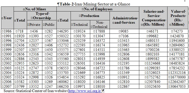
12 Numbers and statistics about mineral deposits and fossil fuels reserves in Iran Proven and probable reserves of metallic and nonmetallic deposits of the country is proclaimed to be around 55 billion tons. There are 62 types of mineral deposits in Iran, which puts it in the category of countries having large number of mineral deposits with high variety (Table-1).

13 Table-1 Deposits of Iran by category
14

15
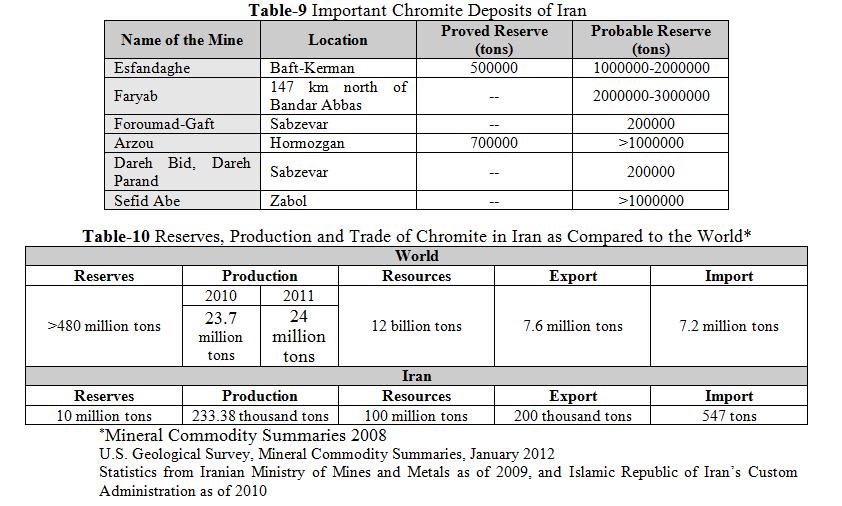
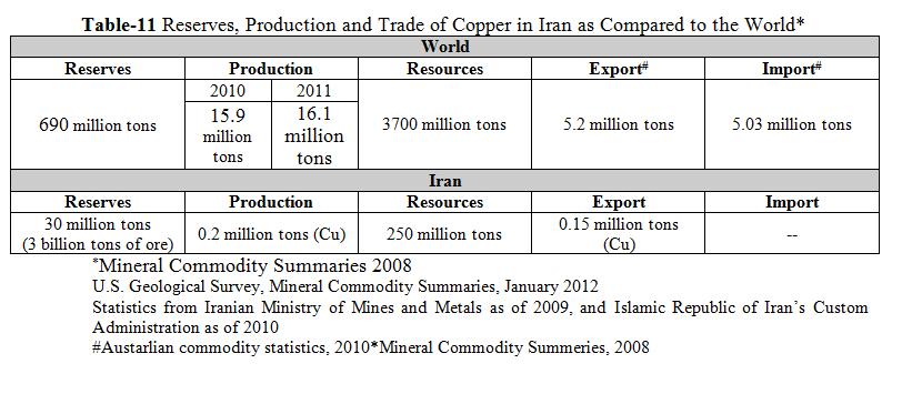
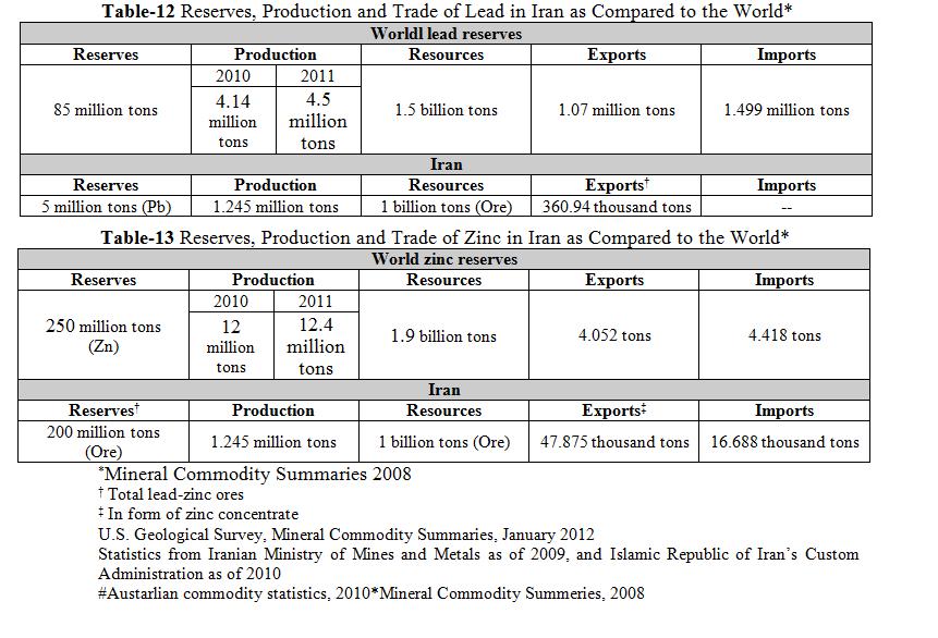
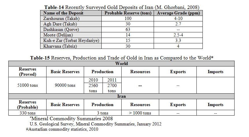
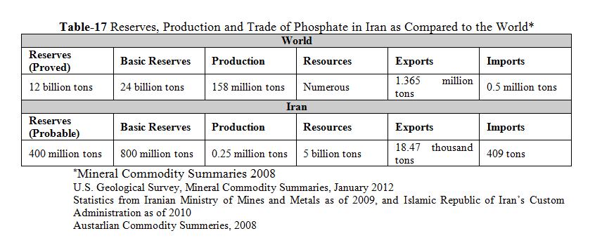
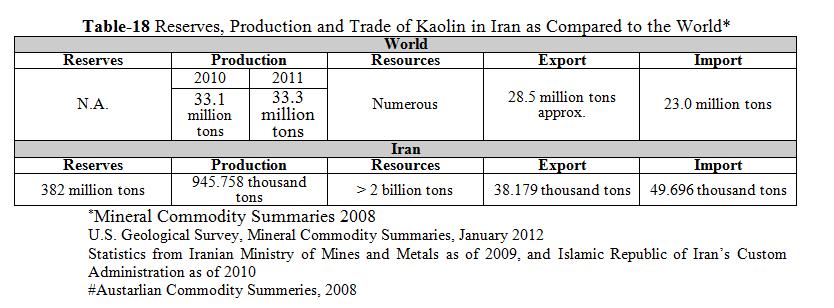
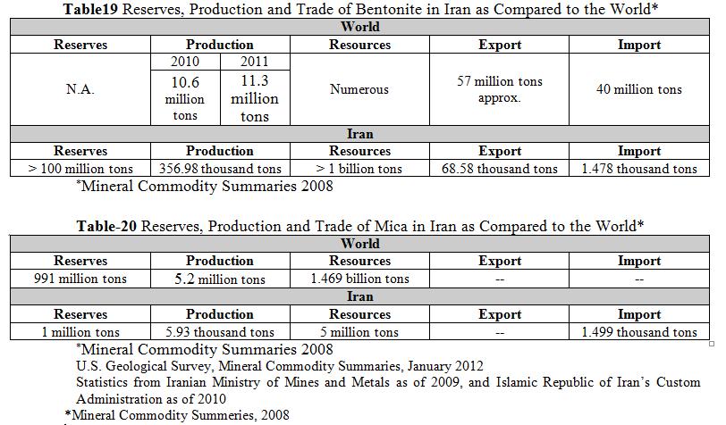
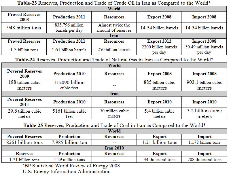
16 Main mineral deposits and fossil fuel reserves in Iran The next slides show numbers and statistics about main mineral deposits and fossil fuel reserves in Iran as compared to the world.

17

18
19
20
21
22

23
24
25
26

27
28
Copyright McGraw-Hill Education. All rights reserved. No reproduction or distribution without the prior written consent of McGraw-Hill Education
 Copyright McGraw-Hill Education. All rights reserved. No reproduction or distribution without the prior written consent of McGraw-Hill Education Tibetan Plateau and Himalaya -southern Asia 11.00.a VE 10X
The Indian Ocean. Copyright 2010 LessonSnips
 The Indian Ocean One of the five major geographic divisions of the world s ocean, the Indian Ocean is located in the Eastern Hemisphere. The Indian Ocean is bounded by three continents: Africa to the west,
Active Tectonic Signs of Taftan Mountain (South Eastern of Iran)
") Open Journal of Geology, 2015, 5, 637-648 Published Online September 2015 in SciRes. http://www.scirp.org/journal/ojg http://dx.doi.org/10.4236/ojg.2015.59056 Active Tectonic Signs of Taftan Mountain (South
Open Journal of Geology, 2015, 5, 637-648 Published Online September 2015 in SciRes. http://www.scirp.org/journal/ojg http://dx.doi.org/10.4236/ojg.2015.59056 Active Tectonic Signs of Taftan Mountain (South
3. The diagram below shows how scientists think some of Earth's continents were joined together in the geologic past.
 1. The map below shows the present-day locations of South America and Africa. Remains of Mesosaurus, an extinct freshwater reptile, have been found in similarly aged bedrock formed from lake sediments
History of Earth. Chapter 9: HISTORY OF EARTH. The Solar System. Early Earth: A Giant Impact! Early Earth. Formation of the Solar System
 Chapter 9: HISTORY OF EARTH The Essential Earth, 2 nd Edition Thomas H. Jordan & John Grotzinger History of Earth Earth is 4.56 Billion Years Old Earth has experienced a rich and diverse history that we
The Lithosphere and the Tectonic System. The Structure of the Earth. Temperature 3000º ºC. Mantle
 The Lithosphere and the Tectonic System Objectives: Understand the structure of the planet Earth Review the geologic timescale as a point of reference for the history of the Earth Examine the major relief
EXISTING GEOLOGICAL INFORMATION
 CHAPER 3 EXISTING GEOLOGICAL INFORMATION 3-1 General Geology of the Surrounding Area (1) General geology and ore deposits in Mongolia Geographically, Mongolia is a country located between Russia to the
SMART NOTES ON INDIAN GEOGRAPHY - 1
 ON INDIAN GEOGRAPHY - 1 Point. Precise. Powerful. www.thesmartnotes.org ON INDIAN GEOGRAPHY - 1 To our Hardworking and persistence aspirants. Success is going from failure to failure without losing enthusiasm.
Global Tectonics. Kearey, Philip. Table of Contents ISBN-13: Historical perspective. 2. The interior of the Earth.
 Global Tectonics Kearey, Philip ISBN-13: 9781405107778 Table of Contents Preface. Acknowledgments. 1. Historical perspective. 1.1 Continental drift. 1.2 Sea floor spreading and the birth of plate tectonics.
Cenozoic: Global Events Ma- Present
 Cenozoic: Global Events 65.5 Ma- Present Major Tectonic Events The Rise of the Himalayas and Closure of the Tethyan Ocean Caused Climate Change Equatorial Ocean Closed Rifting in Western North America
Official languages: French and Arabic.
 Location: Chad is a landlocked Country located in the center of Africa, between 7 o and 23 o North Latitude, 13 o and 24 o East Longitude. Neighbour Country: Libya to the North; Central African Republic
Geology 15 West Valley College. Exam IV: Sierra Nevada
 Geology 15 West Valley College Name Exam IV: Sierra Nevada 1) On the diagram above, where is the Arc- Trench Gap? a. 1 and 3 c. 7 and 8 d. 6 e. 5 and 10 2) On the diagram above, where is the subduction
Distribution of Natural Resources 7 th Grade PSI Science
 Distribution of Natural Resources 7 th Grade PSI Science Name Directions: Humans and animals use natural resources every day. But where are these resources found? The maps below show the distribution of
Heat Flow in the Caspian Black Sea Region and its Tectonic Implications*
 Heat Flow in the Caspian Black Sea Region and its Tectonic Implications* R. I. Kutas 1 Search and Discovery Article #50400 (2011) Posted April 25, 2011 *Adapted from extended abstract prepared for presentation
Unit 1: Geography. For additional information, refer to this website: 1 G e o g r a p h y
 Unit 1: Geography For additional information, refer to this website: http://mryoungtms.weebly.com/ 1 G e o g r a p h y Continents and Oceans SOL USI. 2a Essential Understanding: Continents are large land
Geology of the Batemans Bay region. Geological evolution. The Lachlan Orogen
 Australian Journal of Earth Sciences 1 The word orogen is derived from the ancient Greek language word for mountain building. The Lachlan Orogen The rocks exposed in the Batemans Bay are part of the geological
The Building of the NYC Region
 The Building of the NYC Region Definitions Fall Line marks the area where an upland region (continental bedrock) and a coastal plain meet Piedmont the plateau region of the eastern United States which
Evolution of Continents Chapter 20
 Evolution of Continents Chapter 20 Does not contain complete lecture notes. Mountain belts Orogenesis the processes that collectively produce a mountain belt Includes folding, thrust faulting, metamorphism,
Biology. Slide 1 of 40. End Show. Copyright Pearson Prentice Hall
 Biology 1 of 40 2 of 40 Fossils and Ancient Life What is the fossil record? 3 of 40 Fossils and Ancient Life The fossil record provides evidence about the history of life on Earth. It also shows how different
Figure 1. Examples of vector displacement diagrams for two and three-plate systems.
 Figure 1. Examples of vector displacement diagrams for two and three-plate systems. Figure 2. Relationships between pole of rotation, great circles, ridge segments, small circles, transforms and fracture
12. The diagram below shows the collision of an oceanic plate and a continental plate.
 Review 1. Base your answer to the following question on the cross section below, which shows the boundary between two lithospheric plates. Point X is a location in the continental lithosphere. The depth
GEL 113 Historical Geology
 GEL 113 Historical Geology COURSE DESCRIPTION: Prerequisites: GEL 111 Corequisites: None This course covers the geological history of the earth and its life forms. Emphasis is placed on the study of rock
Basin & Range / Mojave Desert
 Basin & Range / Mojave Desert Basin & Range vs. Great Basin 1 2/20/2016 An overview of the last horst Basin and Range / Mojave Desert Summary: Granitic, volcanic, marine sedimentary, non marine sedimentary,
USU 1360 TECTONICS / PROCESSES
 USU 1360 TECTONICS / PROCESSES Observe the world map and each enlargement Pacific Northwest Tibet South America Japan 03.00.a1 South Atlantic Arabian Peninsula Observe features near the Pacific Northwest
Chapter 2: Plate Tectonics: A Unifying Theory
 Chapter 2: Plate Tectonics: A Unifying Theory Chapter Outline 2.1 Introduction 2.2 Early Ideas About Continental Drift 2.3 What Is the Evidence for Continental Drift? 2.4 Features of the Seafloor 2.5 Earth
Lecture Outlines PowerPoint. Chapter 12 Earth Science 11e Tarbuck/Lutgens
 Lecture Outlines PowerPoint Chapter 12 Earth Science 11e Tarbuck/Lutgens 2006 Pearson Prentice Hall This work is protected by United States copyright laws and is provided solely for the use of instructors
GEOLOGY GL1 Foundation Unit
 Candidate Name Centre Number Candidate Number 2 General Certificate of Education Advanced Subsidiary/Advanced 451/01 GEOLOGY GL1 Foundation Unit P.M. THURSDAY, 10 January 2008 (1 hour) Examiner Question
Section 7. Reading the Geologic History of Your Community. What Do You See? Think About It. Investigate. Learning Outcomes
 Chapter 3 Minerals, Rocks, and Structures Section 7 Reading the Geologic History of Your Community What Do You See? Learning Outcomes In this section, you will Goals Text Learning Outcomes In this section,
The Mesozoic. Wednesday, November 30, 11
 The Mesozoic Periods of the Mesozoic Triassic- First period of the Mesozoic era Jurassic Cretaceous- Last period of the Mesozoic era Breakup of Pangaea Stage one (Triassic) Rifting and volcanism, normal
Terrain Units PALEOGEOGRAPHY: LANDFORM CREATION. Present Geology of NYS. Detailed Geologic Map of NYS
 NYS TOPOGRAPHY Why so? PALEOGEOGRAPHY: LANDFORM CREATION Prof. Anthony Grande AFG 014 Present Geology of NYS Detailed Geologic Map of NYS Generalized Geology Detailed Geology Hot links to the fold out
Mountain Building. Mountain Building
 Mountain Building Mountain building has occurred during the recent geologic past American Cordillera the western margin of the Americas from Cape Horn to Alaska Includes the Andes and Rocky Mountains Alpine
GY 112 Lecture Notes Archean Geology
 GY 112 Lecture Notes D. Haywick (2006) 1 GY 112 Lecture Notes Archean Geology Lecture Goals: A) Time frame (the Archean and earlier) B) Rocks and tectonic elements (shield/platform/craton) C) Tectonics
Continental Landscapes
 Continental Landscapes Landscape influenced by tectonics, climate & differential weathering Most landforms developed within the last 2 million years System moves toward an equilibrium Continental Landscapes
CHAPTER 1. Geo Challenges 1A to 1D. & World Map Activity
 CHAPTER 1 Geo Challenges 1A to 1D & World Map Activity SELECT YOUR CHALLENGE World Map Activity Challenge 1A Challenge 1B Challenge 1C Challenge 1D Challenge 1A WS PG. 2 STEP #1 Label the largest continent
Structural Geology of the Mountains
 Structural Geology of the Mountains Clinton R. Tippett Shell Canada Limited, Calgary, Alberta clinton.tippett@shell.ca INTRODUCTION The Southern Rocky Mountains of Canada (Figure 1) are made up of several
Geologic History of Texas: The Making of Texas Over 1.5 Billion Years
 # 4 Geologic History of Texas: The Making of Texas Over 1.5 Billion Years Dr. Richard Kyle March 24, 2000 Produced by and for Hot Science - Cool Talks by the Environmental Science Institute. We request
PHYSIOGRAPHIC REGIONS OF THE LOWER 48 UNITED STATES
 PHYSIOGRAPHIC REGIONS OF THE LOWER 48 UNITED STATES LAURENTIAN UPLAND 1. Superior Upland ATLANTIC PLAIN 2. Continental Shelf (not on map) 3. Coastal Plain a. Embayed section b. Sea Island section c. Floridian
Geologic Time. Decoding the Age of our Planet & North Carolina
 Geologic Time Decoding the Age of our Planet & North Carolina The Geologic Time Scale Objectives Describe the geologic time scale. Distinguish among the following geologic time scale divisions: eon, era,
Exploration Opportunities in the Middle East
 Exploration Opportunities in the Middle East Richard Herbert R Herbert Associates Ltd Finding Petroleum Middle East Forum Tuesday 16 th May 2017 The Geological Society, London Agenda What defines the Middle
The United States & Canada. A Regional Study of Anglo America
 A Regional Study of Anglo America Landform Regions of the United States & Canada world leaders in agricultural and industrial production because of... VAST LANDS stretch from the Atlantic Ocean on the
PALEOGEOGRAPHY of NYS. Definitions GEOLOGIC PROCESSES. Faulting. Folding 9/6/2012. TOPOGRAPHIC RELIEF MAP of NYS GRADATIONAL TECTONIC
 TOPOGRAPHIC RELIEF MAP of NYS PALEOGEOGRAPHY of NYS Prof. Anthony Grande AFG 2012 Definitions GEOLOGIC PROCESSES Geography: study of people living on the surface of the earth. Geology: the scientific study
Structural Styles and Geotectonic Elements in Northwestern Mississippi: Interpreted from Gravity, Magnetic, and Proprietary 2D Seismic Data
 Structural Styles and Geotectonic Elements in Northwestern Mississippi: Interpreted from Gravity, Magnetic, and Proprietary 2D Seismic Data Nick Loundagin 1 and Gary L. Kinsland 2 1 6573 W. Euclid Pl.,
Plan of Development Mountain Valley Pipeline Project. APPENDIX P Plan for Unanticipated Discovery of Paleontological Resources
 APPENDIX P Plan for Unanticipated Discovery of Paleontological Resources Appendix P Plan for Unanticipated Discovery of Paleontological Resources Prepared by: TABLE OF CONTENTS 1.0 INTRODUCTION... 1 1.1
Questions and Topics
 Plate Tectonics and Continental Drift Questions and Topics 1. What are the theories of Plate Tectonics and Continental Drift? 2. What is the evidence that Continents move? 3. What are the forces that
The Building of a Continent. Delving into Deep Time
 The Building of a Continent Delving into Deep Time Methods for Studying the Past Identifying orogenies Mountain building events Mountains erode Can t study topography Study the evidence they leave behind
PETROLEUM GEOLOGY OF NORTH AFGANISTAN USING GIS TECHNIQUES
 PETROLEUM GEOLOGY OF NORTH AFGANISTAN USING GIS TECHNIQUES CRP 514 Geographic Information System Instructor: Dr. Baqer M. Al- Ramadan SYED HAROON ALI MS GEOLOGY EARTHSCIENCES DEPARTMENT KFUPM I.D.: g201207320
5. Compare the density of the oceanic crust to continental crust. 6. What kind of plate boundary is this? convergent
 The youngest rock is in the middle (at ridge) and it gets older on either side as you move away in a symmetrical pattern. 1. How does the age of the seafloor compare on either side of the ridge? A = youngest
Name Class Date. In the space provided, write the letter of the definition that best matches the term or phrase.
 Skills Worksheet Directed Reading Section: The Changing Continents 1. What is the result of slow movements of tectonic plates? RESHAPING EARTH S CRUST In the space provided, write the letter of the definition
Geologic History. Earth is very, very old
 Geologic History Earth is very, very old Earth s History The history of Earth and the ages of rocks can be investigated and understood by studying rocks and fossils. Evidence of ancient, often extinct
Mesozoic Earth History
 Mesozoic Earth History The Mesozoic Era 251-66 MYA Breakup of Pangea Changes in air and oceanic currents Evolution of new terrestrial and marine life Opening of the Atlantic Ocean Basin Rocky Mountains
Phanerozoic (last 0.54 by) Tectonics Climate Life
 Tectonics Climate Life") Phanerozoic (last 0.54 by) Tectonics Climate Life Tools for Locating Past Continent Positions Fossils depending on climate Alignment of geological features Geometrical fit of continental margins Similarity
Phanerozoic (last 0.54 by) Tectonics Climate Life Tools for Locating Past Continent Positions Fossils depending on climate Alignment of geological features Geometrical fit of continental margins Similarity
Chapter 3. Geology & Tectonics
 Chapter 3 Geology & Tectonics 3.1 Geology The general geological features of Indonesia are shown in Figure 3.1. The basement formation is metamorphic and it is intruded with plutonic formations. They are
BALOCHISTAN FOLDBELT BASIN
 INTRODUCTION BALOCHISTAN FOLDBELT BASIN The Kharan-3 block is located in the Kharan Trough of Balochistan Basin. GEOLOGICAL SETTING The Balochistan Province is an Upper Cretaceous to Recent structurally
Chapter Two. Figure 02_02. Geography of the Ocean Basins. The Sea Floor
 Chapter Two The Sea Floor Geography of the Ocean Basins Figure 02_02 The world ocean is the predominant feature on the Earth in total area. In the Northern Hemisphere, 61% of the total area is ocean. In
REPUBLIC OF CHAD. Ministry of Oil,Mines and Energy
 REPUBLIC OF CHAD Ministry of Oil,Mines and Energy presented by: Mr. DJEDOUBOUM Emmanuel Ambroise and Mr. BRAHIM ABDERAMANE YACINE E-mail: djed_emma@yahoo.fr/brahimyacine93@yahoo.fr 10-14 November,2014/Johannesburg
Chapter 3 Time and Geology
 Chapter 3 Time and Geology Methods of Dating Rocks 1. Relative dating - Using fundamental principles of geology (Steno's Laws, Fossil Succession, etc.) to determine the relative ages of rocks (which rocks
Full file at CHAPTER 2 The Way the Earth Works: Plate Tectonics
 CHAPTER 2 The Way the Earth Works: Plate Tectonics MULTIPLE CHOICE 1. Wegener proposed continental drift after he observed evidence from fossils, glacial deposits, and the fit of the continents that suggested
MAPPING THE EARTH HOW DO YOU FIND A LOCATION ON THE EARTH?
 MAPPING THE EARTH HOW DO YOU FIND A LOCATION ON THE EARTH? UNIT TOPICS TOPIC 1: LATITUDE & LONGITUDE TOPIC 2: FIELD MAPS TOPIC 3: TOPOGRAPHIC MAPS TOPIC 4: NYS LANDSCAPES TOPIC 1: LATITUDE & LONGITUDE
EQ: Discuss main geographic landforms of the U.S. & Canada and examine varied landforms in relation to their lifestyles.
 EQ: Discuss main geographic landforms of the U.S. & Canada and examine varied landforms in relation to their lifestyles. Places & Terms for Discussion Appalachian Mountains Great Plains Canadian Shield
Blocks 31, 32, 33, 34, 35 & 36/03 Southeast Offshore Vietnam
 Blocks 31, 32, 33, 34, 35 & 36/03 Southeast Offshore Vietnam Block 31 32 33 34 35 36/03 Area (km 2) 5,036 4,440 4,630 4,700 4,630 2,950 Sea level (m) 20 20-30 30-40 50 50 50 Seismic 2D (km) 1,294 685 431
Geology 300, Physical Geology Spring 2019 Quiz Ch 19, Plate Tectonics Name
 Geology 300, Physical Geology Spring 2019 Quiz Ch 19, Plate Tectonics Name MULTIPLE CHOICE. Choose the one alternative that best completes the statement or answers the question. 1) The portion of a fracture
Landforms in Canada. Canada is made up of three dis;nct types of landforms: Canadian Shield Highlands Lowlands
 Canada s Landforms What is a Landform? A landform is any physical feature of the Earth s surface having a characteris;c, recognizable shape, produced by natural causes. Landforms include major features
GLY 155 Introduction to Physical Geology, W. Altermann. Press & Siever, compressive forces. Compressive forces cause folding and faulting.
 Press & Siever, 1995 compressive forces Compressive forces cause folding and faulting. faults 1 Uplift is followed by erosion, which creates new horizontal surface. lava flows Volcanic eruptions cover
GO ON. Directions: Use the diagram below to answer question 1.
 d i a g n o s t i c t e s t : e a r t h a n d s p a c e s c i e n c e question 1. 1. What is the correct order (starting from the surface) of Earth s layers? A crust, outer core, inner core, mantle B mantle,
entered a rapid development phase. Annual increased proven reserves are above 500 billion cubic meters (bcm) from 2003, and annual natural gas product
 from 2003, and annual natural gas product") (), entered a rapid development phase. Annual increased proven reserves are above 500 billion cubic meters (bcm) from 2003, and annual natural gas production has increased from 50bcm in 2000 to nearly
(), entered a rapid development phase. Annual increased proven reserves are above 500 billion cubic meters (bcm) from 2003, and annual natural gas production has increased from 50bcm in 2000 to nearly
Unit 5 Possible Test Questions Mesozoic and Cenozoic Eras HISTORICAL GEOLOGY
 Revised 8/16 Unit 5 Possible Test Questions Mesozoic and Cenozoic Eras HISTORICAL GEOLOGY Mesozoic Era Eons, Eras and Periods 1. List the Mesozoic periods in order (oldest to youngest). End of the Paleozoic
Geology 1 st Semester Exam YSBAT
 1. What is the role of a geologist? Geology 1 st Semester Exam YSBAT 2016-2017 2. Earth is subdivided into three main layers based on what? 3. What features do you find at divergent boundaries? 4. Rock
3. GEOLOGY. 3.1 Introduction. 3.2 Results and Discussion Regional Geology Surficial Geology Mine Study Area
 3. GEOLOGY 3.1 Introduction This chapter discusses the baseline study of the geology and mineralization characteristics of the mine study area. The study consolidates existing geological data and exploration
The High Lava Plains Project: Understanding the Causes of Continental Intraplate Tectonomagmatism
 The High Lava Plains Project: Understanding the Causes of Continental Intraplate Tectonomagmatism The High Lava Plains (HLP) of the northwestern USA is one of the most accessible yet least understood examples
24. Ocean Basins p
 24. Ocean Basins p. 350-372 Background The majority of the planet is covered by ocean- about %. So the majority of the Earth s crust is. This crust is hidden from view beneath the water so it is not as
Plate Tectonics: A Unifying Theory
 Plate Tectonics: A Unifying Theory What is Plate Tectonics? - 7 large tectonic plates and many smaller ones that break up the lithosphere - Plates are brittle and float on asthenosphere and glide past
Earth s History. The principle of states that geologic processes that happened in the past can be explained by current geologic processes.
 Earth s History Date: Been There, Done That What is the principle of uniformitarianism? The principle of states that geologic processes that happened in the past can be explained by current geologic processes.
GEOLOGIC MAPS PART II
 EARTH AND ENVIRONMENT THROUGH TIME LABORATORY - EES 1005 LABORATORY FIVE GEOLOGIC MAPS PART II Introduction Geologic maps of orogenic belts are much more complex than maps of the stable interior. Just
Chapter 02 The Sea Floor
 Chapter 02 The Sea Floor Multiple Choice Questions 1. One of the following is not one of the world's major ocean basins: A. Atlantic Ocean B. Arctic Ocean C. Indian Ocean D. Antarctic Ocean E. Pacific
Geologic Time. Geologic Events
 Geologic Time Much of geology is focused on understanding Earth's history. The physical characteristics of rocks and minerals offer clues to the processes and conditions on and within Earth in the past.
The Earth s Structure. The Lithosphere and Tectonic. The Lithosphere and Tectonic. System. Chapter 12. The Earth s Interior
 The Lithosphere and Tectonic System Chapter 12 The Lithosphere and Tectonic System The theory describing the changing configuration of the continents through time is called plate tectonics. Plate tectonic
Earth Science, (Tarbuck/Lutgens) Chapter 10: Mountain Building
 Chapter 10: Mountain Building") Earth Science, (Tarbuck/Lutgens) Chapter 10: Mountain Building 1) A(n) fault has little or no vertical movements of the two blocks. A) stick slip B) oblique slip C) strike slip D) dip slip 2) In a(n) fault,
Earth Science, (Tarbuck/Lutgens) Chapter 10: Mountain Building 1) A(n) fault has little or no vertical movements of the two blocks. A) stick slip B) oblique slip C) strike slip D) dip slip 2) In a(n) fault,
Geologic Trips San Francisco and the Bay Area
 Excerpt from Geologic Trips San Francisco and the Bay Area by Ted Konigsmark ISBN 0-9661316-4-9 GeoPress All rights reserved. No part of this book may be reproduced without written permission in writing,
Plate Tectonics 22/12/2017
 Map of the tectonic plates. Plate Tectonics In 1912 the meteorologist Alfred Wegener independently developed what he called continental drift, (expanded in his 1915 book The Origin of Continents and Oceans).
Geology of Quesnel and Stikine terranes and associated porphyry deposits. Jim Logan Paul Schiarizza
 Geology of Quesnel and Stikine terranes and associated porphyry deposits Jim Logan Paul Schiarizza Quesnel and Stikine terranes Major cordilleran terranes characterized by similar Late Triassic Early Jurassic
3/5/05 Dr. Stewart 1
 I. Physiography of Appalachian Mountains A. Introduction 1. These mountains extend from NE Canada to Georgia 2. They are the remains of a deeply eroded, ancient mountain chain once larger than the Himalayans
SAMPLE QUESTIONS FOR GEOLOGY 103, TEST 1
 SAMPLE QUESTIONS FOR GEOLOGY 103, TEST 1 The correct answers are listed at the bottom (no peeking!). These questions are to give you an idea of the type of questions that will be asked. They are not a
Chapter 21 Southwest Asia: Harsh & Arid Lands
 Name Hour Chapter 21 Southwest Asia: Harsh & Arid Lands Essential Question: How has the physical geography of Asia influenced the development of these regions (i.e. history, population distribution, &
What is the largest country in the world? Russia
 What is the largest country in the world? #1 Russia CSCOPE 2007 2 Russia Dimensions #2-3 Spans 11 Time Zones From East to West: Gulf of Finland to Alaska From North to South: Above the Arctic Circle to
ISSUED BY KENDRIYA VIDYALAYA - DOWNLOADED FROM
 Chapter-4 DISTRIBUTION OF OCEANS AND CONTINENTS GIST OF THE LESSON: CONTINENTAL DRIFT, EVIDENCES TO SUPPORT CONTINENTAL DRIFT, FORCES OF DRIFTING, POST DRIFT STUDIES, OCEAN FLOOR CONFIGURATION, DISTRIBUTION
دیدمآ شوخ Welcome to
 به خوش آمدید Welcome to Territory Baluchistan is a historic region of the Asian subcontinent, comprised of parts of eastern Iran, western Pakistan and southwest Afghanistan. Makran is the southernmost
Unit 5: Earth s History Practice Problems
 Name: Date: 1. Which bedrock would be most likely to contain fossils? A. Precambrian granite B. Cambrian shale C. Pleistocene basalt D. Middle-Proterozoic quartzite 6. Base your answer(s) to the following
Plio-Pleistocene Geology
 UNIVERSITY OF SOUTH ALABAMA GY 112: Earth History Plio-Pleistocene Geology Instructor: Dr. Douglas W. Haywick Last Time A) Cenozoic Tectonics Western North American tectonic provinces Plateaus and canyons
North Greenland collection of oblique aerial photographs - (Twin Otter photos)
") North Greenland collection of oblique aerial photographs - (Twin Otter photos) The Geological Survey of Greenland (now part of the Geological Survey of Denmark and Greenland: GEUS) carried out a systematic
North Greenland collection of oblique aerial photographs - (Twin Otter photos) The Geological Survey of Greenland (now part of the Geological Survey of Denmark and Greenland: GEUS) carried out a systematic
Earth s Structure and Surface
 Earth s Structure and Surface Structure of the Earth The earth is thought have originated about 4.5 billion years ago from a cloud or clouds of dust. The dust was the remains of a huge cosmic explosion
3 Geological situation of Iran
 Tab. 5: Overview about important mineral phases, aqueous species and oxidation processes. Primary minerals galena (PbS), sphalerite (ZnS), pyrite (FeS 2 ), calcite (CaCO 3 ), dolomite (CaMg(CO 3 ) 2 ),
INTRODUCTION. Climate
 INTRODUCTION Climate Landslides are serious natural disasters in many parts of the world. Since the past 30 years, rainfall triggered landslides and debris flows had been one of the natural disasters of
2.1. Central Indus Basin:
 14 2.1. Central Indus Basin: Research area lies in the Central Indus Basin of Pakistan. Central Indus Basin may be divided into following broad tectonic divisions from east to west (Kadri, 1995) (1) Punjab
Crustal Activity. Plate Tectonics - Plates - Lithosphere - Asthenosphere - Earth s surface consists of a major plates and some minor ones
 Name: Date: Period: Tectonics The Physical Setting: Earth Science CLASS NOTES Tectonics - s - Lithosphere - Asthenosphere - Earth s surface consists of a major plates and some minor ones The plates are
... Asia. Based on Bloom s Taxonomy. Human & Movement. Location Place. Regions. Environment. Interactions
 ... Asia Location Place Human & Environment Interactions Movement Regions LEVEL 1 Knowledge Match Show or Label List Information Recall Details (5Ws + H) Find Information LEVEL 2 Comprehension LEVEL 3
The Sea Floor. Chapter 2
 The Sea Floor Chapter 2 Geography of the Ocean Basins World ocean is the predominant feature on the Earth in total area Northern Hemisphere = 61% of the total area is ocean. Southern Hemisphere = about
Before Plate Tectonics: Theory of Continental Drift
 Before Plate Tectonics: Theory of Continental Drift Predecessor to modern plate tectonics Shape and fit of the continents was the initial evidence Snider-Pelligrini (1858) Taylor (1908) Wegner (1915) Fig.
KIPP: Inspire Academy Social Studies Benchmark 1 PART I. Use the map of Missouri to answer questions 7-9.
 PART I 1) A physical map key shows: A. Climate B. Cities and borders C. Elevation and water depth D. Geographic features Use the map of Missouri to answer questions 7-9. 2) Lines of latitude: A. Are parallel
NAME HOMEWORK ASSIGNMENT #4 MATERIAL COVERS CHAPTERS 19, 20, 21, & 2
 NAME HOMEWORK ASSIGNMENT #4 MATERIAL COVERS CHAPTERS 19, 20, 21, & 2 Assignment is due the beginning of the class period on December 14, 2004. Mark answers on a scantron sheet, which will be provided.
MOR TIME TEACHERS. ONCE UPON A TIME Activity Overview BIG IDEA
 MOR TIME 04 Activity Overview BIG IDEA OBJECTIVE BACKGROUND The geologic time scale can be challenging for students to understand. This activity explores how scientists divide the Earth s long history