Director s Report. Yehuda'Bock
|
|
|
- Beverley Newman
- 5 years ago
- Views:
Transcription
1 Director s Report Yehuda'Bock Institute'of'Geophysics'and'Planetary'Physics'(IGPP) Scripps'Institution'of'Oceanography'(SIO) University'of'California'San'Diego'(UCSD) May'10,'2018 SIO,'La'Jolla
2 Outline People CRTN*Status CSRS*Epoch* *(NAD83) Dynamic*Datum New*SOPAC/CSRC*Web*Interface
engineer:'Matt'Norenberg Radio)Engineer:'D.")
3 Director:)Yehuda'Bock Coordinator:)Maria'Turingan Analysis:'Peng'Fang System)and)Database)Administrator:'Anne'Sullivan Programmers:'Allen'Nance,'Songnian'Jiang Field)engineer:'Matt'Norenberg Radio)Engineer:'D.'Glen'Offield Postdoctoral)Researchers:'Emilie'Klein,'Junle'Jiang Graduate'Students:'Dara'Goldberg,'Dorian'Golriz Consultant:'John'Canas,'PLS
Dougherty Treasurer: Jim)McNeil Member: Art)Andrew Member: Bryan)Banister Member:,Ken)Joyce")
Steve)Constable NGS,Pacific,Southwest,Regional,Advisor:)Dana)Caccamise")
4 CSRC Executive Committee Chairperson:,Kimberley)Holtz Vice/Chairperson:,Mike)Berber Secretary: Thomas)Dougherty Treasurer: Jim)McNeil Member: Art)Andrew Member: Bryan)Banister Member:,Ken)Joyce Member:,John)Tosto Past,Chairperson:,Rich)Maher UCSD,representative:)John)Orcutt Director,of,IGPP:)Steve)Constable NGS,Pacific,Southwest,Regional,Advisor:)Dana)Caccamise NGS)California,Geodetic,Coordinator:)Scott)Martin CSRC,Director:)Yehuda)Bock
5 CRTN Consortium Members 1. City'of'Los'Angeles,'Department'of'Public'Works,'Bureau'of'Engineering' Cesar'Bregaudit,' Robert'Nielsen 2. Orange'County'Public'Works' Art'Andrew 3. Riverside'County'Flood'Control'and'Water'Conservation'District' Jim'McNeil 4. San'Diego'County,'Department'of'Public'Works' Ray'Mathe 5. Riverside'County'Transportation'Department' David'McMillan,'Ed'Hunt,'Tim'Rayburn 6. Santa'Clara'Valley'Water'District' Kris'Puthoff 7. City'of'Long'Beach,'Gas'and'Oil' Kimberley'Holtz 8. California'Department'of'Transportation' Scott'Martin,'Mark'Turner 9. Swift'Navigation' Grant'Hausler 10. Scripps'Institution'of'Oceanography,'University'of'California,'San'Diego' Yehuda'Bock 11. California'Spatial'Reference'Center Kimberley'Holtz
6 CRTN Contributing Members 1. Adkan(Engineers,(Tom(Chrisman 2. Bock(and(Clark(Corporation,(Eric(Berben 3. Burkett(and(Wong(Engineers,(Casey(Lynch 4. California(American(Water,(Stephen(San(Nicolas 5. Cardno(Inc.,(Sean(Fitzpatrick 6. Coast(Surveying,(Inc.,(Ken(Kasbohm,(Gwen(del(Castillo 7. Dixon(Marine(Services,(Inc.,(Jeff(Haran 8. East(Bay(Municipal(Water(District,(Steve(Martin(and(Tara(Sweet 9. East(Bay(Regional(Parks,(Duncan(Marshall 10. Helix(Water(District,(Rebecca(Vanegas 11. Honda(Research(Institute(USA,(Inc.,(Paul(Cummings 12. Japan(Aerospace(Exploration(Agency,(Satoshi(Kogure,(Mike(Ramirez 13. Terra[Mark(Surveying,(Robert(Shellman 14. LocusView(Solutions,(Eric(Gakstatter 15. MBS(Land(Surveys,(Michael(B.(Stanton 16. PSOMAS,(Jeremy(Evans 17. Quantum(Spatial,(Kenny(Roberts 18. Rail(Surveyors(and(Engineers(Incorporated,(Cody(Festa 19. RBF(Consulting,(Company(of(Michael(Baker(Corporation 20. RSE(Inc.,(Cody(Festa 21. Salsbury(Engineering,(Inc.,(Jon(Gauthier 22. San(Francisco(Water(Department,(Edward(Peterson 23. Southern(California(Gas(Company,(Gregory(Irwin 24. SubCarrier(Systems(Corp.,(David(Kelley 25. US(Army(Corps(of(Engineers,(Ronald(Spencer

7 CRTN Station May 8, :00 AM Started'in'2003,'1'Hz'RTCM'3.0'data'are' available'from'420'stations'from'2'crtn' servers'(sc:'206'stationsb'nc:'241' stations)'at'sopac'with'a'latency'of' ~0.4L1.0's.'Data'directly'collected'from'' SCIGN/PBO'stations'via'UCSD s' HPWREN'communications'(48'stations),' and'from'unavco/pbo,'usgs' Pasadena,'UC'Berkeley,'Caltrans'and' Orange'County'servers. CSRS'Epoch' '(NAD83)' coordinates'transmitted,'with'station' metadata'in'rtcm'3.0'format 1059'registered'Users
8 CRTN Accounts An#NTRIP#account#(username#&#password)#is#required,#requested#by#on=line# registration:#( 1059#companies/agencies#registered#(up#from#918#at#2017#Fall#Meeting) >#30#multi=account#users More#visibility#via#Google#searches Recent#accounts 964.##United#States#Department#of#Defense,#San#Bernardino#(testing#and#training) 1016.#Tangent#Systems,#Orange#County#(Telecom,#Technology,#Internet#and# Electronics,#locations#for#potential#construction) 1022.##US#Survey#Supply,#San#Diego#(GNSS#sales#and#training) 1030.##Big#W#Sales,#Monterey#County#(agricultural#tractor#steering) 1041.##Lyft,#San#Francisco#(self#driving#vehicles)# 1045.##Riverside#Construction#(bridge#repair) 1058.##Charles#Usher#Wines,#Santa#Clara#(drones#for#vineyard#agriculture)#

9 Connections to CRTN Stations through January 2018
10 PROJECT(REPORT California(Spatial(Reference(System CSRS(Epoch( ((NAD83) Yehuda(Bock,(Peng(Fang(and(Gregory(R.(Helmer Submitted:*January*4,*2018 Rolled*Out:*March*1,*2018 Per*Interagency*Agreement*52A0103* Regents*of*the*University*of*California*& California*Department*of*Transportation Scripps*Institution*of*Oceanography*(SIO)
 957%stations%in%California%and%borders%of% Arizona,%Nevada%and%Oregon 849%active%stations=%108%inactive%stations Deliverables: Project%report Table%1:%Geodetic%Coordinates%ITRF2014%&%")
11 New Geodetic Datum for California: CSRS Epoch (NAD83) 957%stations%in%California%and%borders%of% Arizona,%Nevada%and%Oregon 849%active%stations=%108%inactive%stations Deliverables: Project%report Table%1:%Geodetic%Coordinates%ITRF2014%&% NAD83%(2011)%+%uncertainties%(2%sigma)=% orthometric%heights Table%2:%Quality%control Table%3:%Motions%wrt%previous%Epoch%dates% ( ,% ,% ) stations
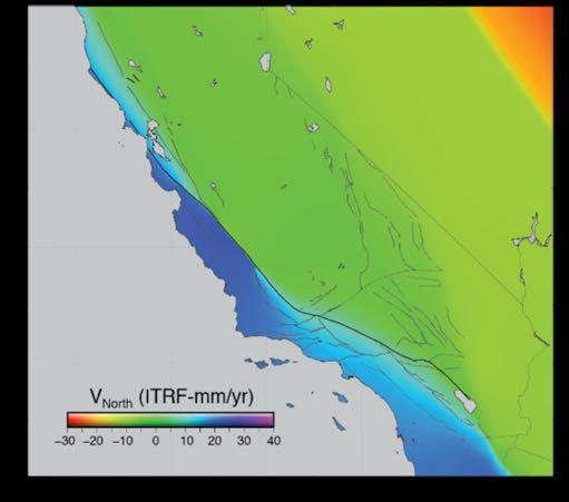
12 CSRS Epoch (NAD83) Station Velocities ITRF2014 NAD83

13 Significant Earthquakes in California %Ferndale 2014%South%Napa 2004%Parkfield 2003%San%Simeon 1999%Hector%Mine 2010%El%Mayor%3 Cucapah

14 Displacement Time Series ( ) Three stations southern California Vandenberg Air Force Base, Pinyon Flat Observatory, Jet Propulsion Laboratory Effects of 3 three earthquakes, antenna changes, landslide

15 Detrended Displacement Time Series ( ) Coseismic & Postseismic Motions North 0.16 ft 0.24 ft DHLG GLRS CRRS East Up

16 UCD1 Sacramento Valley Transect RMS = 1.94 mm RMS = 1.88 mm Sacramento Valley P265 UCD1 P264 RMS = mm

17 P Sacramento Valley Transect RMS = 0.99 mm RMS = 1.34 mm Sacramento Valley P RMS = 3.78 mm

18 5 P264 Sacramento Valley Transect RMS = 0.92 mm RMS = 1.17 mm P264 Sacramento Valley -20 RMS = 3.54 mm


19 P631 Magmatic Effects Uplift at Long Valley Caldera RMS = 6.73 mm RMS = 1.90 mm Mammoth Lakes Network p RMS =

20 Transient Non-Tectonic Horizontal Motions from Aquifer Recharge Continuous(GPS(horizontal( (arrows)(and(vertical((color( scale)(displacements(in(the( period(2005.0>2005.4(in(the( San(Gabriel(Valley,(southern( California(caused(by(aquifer( recharge(due(to(heavy(rains.( The(station(LONG(had(an(uplift( of(47(mm.(
21 PROJECT(REPORT Investigations(into(a(Dynamic(Datum(for(California Yehuda(Bock(and(Emilie(Klein Draft,(May(10,(2018 Per$Interagency$Agreement$52A0103$ Regents$of$the$University$of$California$& California$Department$of$Transportation Scripps$Institution$of$Oceanography$(SIO)


22 Iterate Production of Displacement Time Series SOPAC$ Database GPS$observables$+$ metadata The$displacement$time$series$ are$modeled$from$their$start,$ re3evaluated$after$every$new$ week$of$daily$gps$solutions$is$ available.$ Earth$models SECTOR GAMIT$ Analysis$ GLOBK$ Analysis Time$ Series$ Analysis Antenna models GPS$ Explorer SOPAC$ Archive Every$week,$a$new$dynamic$ datum$grid$is$calculated$and$ archived.$each$grid$represents$ the$changes$in$displacements$ since$the$start$of$the$time$ series.$the$transformation$ between$any$two$epoch$dates$ is$obtained$by$subtracting$the$ two$corresponding$grids.$ EpochDDate Coordinates Time$series$ parameters Raw$time$ series Residual$ time$series Velocities

23 SECTOR Utility: Epoch-Date Coordinates Allows Transformation of Coordinates between Epochs But Only for CSRN Reference Stations Not for Arbitrary Stations


24 Dynamic Datum: Transform Coordinates between Epochs at an Arbitrary Location t 0 start of time series t 1 arbitrary time t 2 today or any other time

25 San Andreas Fault System A"region"~200"km"wide" centered"on"the"fault"is" deforming"approximately"as" an"inverse"tangent"function" due"to"elastic"deformation" of"the"crust"and"other" tectonic"processes." Characteristics"of"tangent" function"are"depending"of" the"creep"rate"on"the"fault," highly"variable."these% motions%are%taken%into% account%when%adopting%an% underlying%geophysical% model,%rather%than%just% interpolate%surface% displacements. Tong et al. (2014) Geophysical model of the San Andreas fault system (horizontal)

26 Predicted Surface Velocity Surface from Geophysical Model Velocity)surface)in)mm/yr)predicted)by)the)fault)model)of)Tong)et)al.)(2014),)based)on)the1996B 2014)GPSB and)insarbbased)velocities,)eastward)(left))and)northward)(right))components.
Napa) earthquake)postseismic SAF)creeping) section 2004)Mw6.")
El)Mayor=Cucapah earthquake)postseismic Velocity)residuals)between) the)tong)et)al.")
time)series) indicating)areas)of)significant) differences)due)to)postseismic)")
27 Deviations from Geophysical Model 2014)Mw6.1)Napa) earthquake)postseismic SAF)creeping) section 2004)Mw6.0)Parkfield) earthquake)postseismic Long)Valley) Caldera SAF 2010)Mw)7.2)El)Mayor=Cucapah earthquake)postseismic Velocity)residuals)between) the)tong)et)al.)(2014))time= independent)fault)model)and) the)sopac)time=dependent) displacement)time)series) indicating)areas)of)significant) differences)due)to)postseismic) deformation)for)3) earthquakes,)magmatic) inflation)at)long)valley) caldera,)and)creep)along)the) San)Andreas)fault.! Time)dependent processes
 A) observed)(blue))vs)model)predicted)(red))displacement)fieldd B)) residuals)=)observedfmodeledd) C))")
28 Deviations from Geophysical Model Modeling)methodology)to)transform)from)survey)epoch)t)=) )to) :) A) observed)(blue))vs)model)predicted)(red))displacement)fieldd B)) residuals)=)observedfmodeledd) C)) surface)interpolation)of)residuals)for)the)eastward)component.

29 Methodology for Creating Horizontal Surface Displacement Grids D. Sum&of&the&geophysical& model&prediction&and& the&surface& interpolation&of& residuals&displacement& for&the&eastward& component
\"and\"the\"surface\"interpolation\"of\"the\"observed?model\"residuals\"from\"2014.00\"to\" 2017.")
30 Dynamic Geophysical-based Model at a particular epoch t (DGbM t ) DGbM :"Horizontal"surface"displacement"field"(cm)"of"the"upgraded"model"at"the" epoch" "as"a"sum"of"the"time?independent"model"prediction"from"tong"et"al." (2014)"and"the"surface"interpolation"of"the"observed?model"residuals"from" "to" "in"A)"eastward"and"B)"northward"components.
&from&DGbM 2017.")
31 Horizontal Residual Surface for DGbM Final&residual&horizontal&displacement&grids&(mm)&from&DGbM B&A)&eastward,&B)&northward.

32 Vertical Surface Displacement Grid for DDbM DDbM Vertical+surface+displacement+grid+(mm)+represented+with+2+color+scales

33

34 Implementation of Dynamic Datum CRTN%Server RTCM%Network%Auxiliary% Station%Data%Message%1014% Station Position Epoch&Date ITRF%Coordinates Data RTCM{ Metadata Epoch&Date& correction Surveyor/Data%Controller How$do$we$inform$users$on$problematic$areas?

35 New SOPAC and CSRC Web Pages
36 Questions?
CSRC Director s Report
 CSRC Director s Report C S R C Yehuda Bock Scripps Orbit and Permanent Array Center (SOPAC) California Spatial Reference Center (CSRC) Scripps Institution of Oceanography La Jolla CSRC Coordinating Council
Separating Tectonic, Magmatic, Hydrological, and Landslide Signals in GPS Measurements near Lake Tahoe, Nevada-California
 Separating Tectonic, Magmatic, Hydrological, and Landslide Signals in GPS Measurements near Lake Tahoe, Nevada-California Geoffrey Blewitt, Corné Kreemer, William C. Hammond, & Hans-Peter Plag NV Geodetic
Lab 9: Satellite Geodesy (35 points)
") Lab 9: Satellite Geodesy (35 points) Here you will work with GPS Time Series data to explore plate motion and deformation in California. This lab modifies an exercise found here: http://www.unavco.org:8080/cws/pbonucleus/draftresources/sanandreas/
Lab 9: Satellite Geodesy (35 points) Here you will work with GPS Time Series data to explore plate motion and deformation in California. This lab modifies an exercise found here: http://www.unavco.org:8080/cws/pbonucleus/draftresources/sanandreas/
GPS Strain & Earthquakes Unit 5: 2014 South Napa earthquake GPS strain analysis student exercise
 GPS Strain & Earthquakes Unit 5: 2014 South Napa earthquake GPS strain analysis student exercise Strain Analysis Introduction Name: The earthquake cycle can be viewed as a process of slow strain accumulation
How GNSS CORS in Japan works for geodetic control and disaster mitigations
 ICG Working Group D Reference Frames, Timing and Applications How GNSS CORS in Japan works for geodetic control and disaster mitigations ICG11, Nov. 7-11, 2016, Sochi, Russia Hiromichi TSUJI Geodetic Observation
Case Study of Japan: Crustal deformation monitoring with GNSS and InSAR
 Technical Seminar Reference Frame in Practice, Case Study of Japan: Crustal deformation monitoring with GNSS and InSAR Basara Miyahara miyahara-b96ip@milt.go.jp Geospatial Information Authority of Japan
Analysis of Vertical Velocities from BARGEN Continuous GPS Data at Yucca Mountain, Southern Nevada
 Analysis of Vertical Velocities from BARGEN Continuous GPS Data at Yucca Mountain, Southern Nevada Emma Hill and Geoffrey Blewitt Nevada Bureau of Mines and Geology/178 University of Nevada, Reno Reno,
to: Interseismic strain accumulation and the earthquake potential on the southern San
 Supplementary material to: Interseismic strain accumulation and the earthquake potential on the southern San Andreas fault system by Yuri Fialko Methods The San Bernardino-Coachella Valley segment of the
Semi-Dynamic Datum of Indonesia
 Technical Seminar Reference Frame in Practice, Semi-Dynamic Datum of Indonesia H.Z. Abidin, A.B. Wijanarto, S.T. Wibowo, Susilo, J. Efendi Geospatial Information Agency, Indonesia (BIG) Sponsors: Page
Determination of Current Velocity Field (Rate) of North Anatolian Fault in Izmit-Sapanca Segment
 of North Anatolian Fault in Izmit-Sapanca Segment") Determination of Current Velocity Field (Rate) of North Anatolian Fault in Izmit-Sapanca Segment Cetin MEKIK, Bulent TURGUT, Haluk OZENER, Turkish Republic INTRODUCTION Turkey is geologically the part
Determination of Current Velocity Field (Rate) of North Anatolian Fault in Izmit-Sapanca Segment Cetin MEKIK, Bulent TURGUT, Haluk OZENER, Turkish Republic INTRODUCTION Turkey is geologically the part
Contents... GIS Approach. 4D Geo-referenced Database Approach for GIS. G IS Specific GIS Applications. FIG Working Week 2004.
 FIG Working Week 2004 4D Geo-referenced Database Approach for GIS Components of GIS GIS Approach How to Produce Maps Contents... Everything is moving with Earth by Time Why 4D Geo-referenced Database Design
Town of Chino Valley. Survey Control Network Report. mgfneerhg mc N. Willow Creek Road Prescott AZ
 Town of Chino Valley Survey Control Network Report mgfneerhg mc. 2050 N. Willow Creek Road Prescott AZ 86301 928-771-2376 Page 1 of 70 Table of Contents Town of Chino Valley Survey Datum Outline A short
ESTIMATES OF HORIZONTAL DISPLACEMENTS ASSOCIATED WITH THE 1999 TAIWAN EARTHQUAKE
 ESTIMATES OF HORIZONTAL DISPLACEMENTS ASSOCIATED WITH THE 1999 TAIWAN EARTHQUAKE C. C. Chang Department of Surveying and Mapping Engineering Chung Cheng Institute of Technology, Taiwan, ROC ABSTRACT A
GEODETIC NETWORK OF SAUDI ARABIA AND FIDUCIAL STATIONS. GFN OF Saudi Arabia in Based on ITRF2000 Datum
 STUDIES OF TECTONIC MOVEMENTS IN SAUDI ARABIA USING CORS M. Al Rajhi, Ali Al Omar, R. Yanar, F. Kartal, K. Eren, SUBJECT TO TALKS BACKGROUND GEODETIC NETWORK OF SAUDI ARABIA AND FIDUCIAL STATIONS GFN OF
Syllabus and Course Description Geophysical Geodesy Fall 2013 GPH 411/611
 Syllabus and Course Description Geophysical Geodesy Fall 2013 GPH 411/611 Course Location: LME 422 Course Time: Tuesday & Thursday 12:00-1:15 Units: 3 Instructor Name: Bill Hammond Office Location: SEM
Regional deformation and kinematics from GPS data
 Regional deformation and kinematics from GPS data Jessica Murray, Jerry Svarc, Elizabeth Hearn, and Wayne Thatcher U. S. Geological Survey Acknowledgements: Rob McCaffrey, Portland State University UCERF3
High Rate GPS Solutions
 High Rate GPS Solutions High rate GPS data (1 Hz or higher) Network solution Fixed a local reference clock Bias fixed Sub daily position estimates solutions Position becomes stochastic parameter Fairly
LAB: PLATE TECTONICS GOAL: Calculate rates of plate movement
 Name LAB: PLATE TECTONICS GOAL: Calculate rates of plate movement Rates of plate movement are calculated by measuring the distance rocks have moved since they formed. Rates are expressed in cm per year
Today: Basic regional framework. Western U.S. setting Eastern California Shear Zone (ECSZ) 1992 Landers EQ 1999 Hector Mine EQ Fault structure
 1992 Landers EQ 1999 Hector Mine EQ Fault structure") Today: Basic regional framework Western U.S. setting Eastern California Shear Zone (ECSZ) 1992 Landers EQ 1999 Hector Mine EQ Fault structure 1 2 Mojave and Southern Basin and Range - distribution of strike-slip
Today: Basic regional framework Western U.S. setting Eastern California Shear Zone (ECSZ) 1992 Landers EQ 1999 Hector Mine EQ Fault structure 1 2 Mojave and Southern Basin and Range - distribution of strike-slip
A unified analysis of crustal motion in Southern California, : The SCEC crustal motion map
 JOURNAL OF GEOPHYSICAL RESEARCH, VOL. 116,, doi:10.1029/2011jb008549, 2011 A unified analysis of crustal motion in Southern California, 1970 2004: The SCEC crustal motion map Z. K. Shen, 1,2 R. W. King,
NATRF 2022 AND LDP OCTOBER 11, 2017
 NATRF 2022 AND LDP OCTOBER 11, 2017 MODERNIZATION OF THE NSRS Why? Leaving passive control marks behind and relying solely on the CORS network for 3D positions: Older methodology relies on terrestrial
Fusion of Geodesy and GIS at NOAA s National Geodetic Survey
 Fusion of Geodesy and GIS at NOAA s National Geodetic Survey Esri Survey Summit July 6-9, 2013 San Diego, CA Michael Dennis, RLS, PE michael.dennis@noaa.gov The Plan Background NGS Data Explorer New Datasheet
GPS Position Time JPL
 GPS Position Time Series @ JPL Mars Science Laboratory! Susan Owen Jet Propulsion Laboratory, California Institute of Technology Angelyn Moore, Sharon Kedar, Zhen Liu, Frank Webb, Mike Heflin, Shailen
Regional Geodesy. Shimon Wdowinski. MARGINS-RCL Workshop Lithospheric Rupture in the Gulf of California Salton Trough Region. University of Miami
 MARGINS-RCL Workshop Lithospheric Rupture in the Gulf of California Salton Trough Region Regional Geodesy Shimon Wdowinski University of Miami Rowena Lohman, Kim Outerbridge, Tom Rockwell, and Gina Schmalze
Deformation monitoring and analysis using Victorian regional CORS data
 Journal of Global Positioning Systems (2005) Vol. 4, No. 1-2: 129-138 Deformation monitoring and analysis using Victorian regional CORS data Kefei Zhang 1, Youjian Hu 1,2, Gangjun Liu 1, Falin Wu 1 and
Your Advisor Said, Get the GPS Data and Plot it. Jeff Freymueller Geophysical University of Alaska Fairbanks
 Your Advisor Said, Get the GPS Data and Plot it Jeff Freymueller Geophysical Ins@tute University of Alaska Fairbanks Actual GPS Data GPS Data are phase and pseudorange data that measure distances to satellites.
Spatiotemporal filtering using principal component analysis and Karhunen-Loeve expansion approaches for regional GPS network analysis
 JOURNAL OF GEOPHYSICAL RESEARCH, VOL. 111,, doi: 10.1029/2005JB003806, 2006 Spatiotemporal filtering using principal component analysis and Karhunen-Loeve expansion approaches for regional GPS network
A Deformation Model to support a Next Generation Australian Geodetic Datum
 A Deformation Model to support a Next Generation Australian Geodetic Datum Richard Stanaway, Surveying and Geospatial Engineering School of Civil and Environmental Engineering multi-gnss + augmentation
Slip Rates Estimate of Western North Anatolian Fault System in Turkey
 Slip Rates Estimate of Western North Anatolian Fault System in Turkey Haluk OZENER, Asli DOGRU, Bahadir AKTUG, Semih ERGINTAV, Bulent TURGUT, Onur YILMAZ, Kerem HALICIOGLU, Onur GURKAN, Turkey Keywords:
HIGH-RESOLUTION AIRBORNE LIDAR/CCD MAPPING OF SAN ANDREAS FAULT
 HIGH-RESOLUTION AIRBORNE LIDAR/CCD MAPPING OF SAN ANDREAS FAULT Charles Toth, Dorota A. Grejner-Brzezinska and Michael Bevis The Center for Mapping Satellite Positioning and Inertial Navigation (SPIN)
FORMAT FOR TECHNICAL PAPERS
 TOWARDS A MODERNIZED GEODETIC DATUM FOR NEPAL: OPTIONS FOR DEVELOPING AN ACCURATE TERRESTRIAL REFERENCE FRAME FOLLOWING THE APRIL 25, 2015 MW7.8 GORKHA EARTHQUAKE Chris PEARSON 1, Niraj MANANDHA 2 ABSTRACT
Plate Boundary Observatory Working Group for the Central and Northern San Andreas Fault System PBO-WG-CNSA
 Plate Boundary Observatory Working Group for the Central and Northern San Andreas Fault System PBO-WG-CNSA Introduction Our proposal focuses on the San Andreas fault system in central and northern California.
Far-reaching transient motions after Mojave earthquakes require broad mantle flow beneath a strong crust
 Click Here for Full Article GEOPHYSICAL RESEARCH LETTERS, VOL. 34, L19302, doi:10.1029/2007gl030959, 2007 Far-reaching transient motions after Mojave earthquakes require broad mantle flow beneath a strong
Realizing a geodetic reference frame using GNSS in the presence of crustal deformations: The case of Greece
 Realizing a geodetic reference frame using GNSS in the presence of crustal deformations: The case of Greece M. Gianniou National Cadastre and Mapping Agency S.A. Outline 1. Introduction 2. Deformation
Kinematics of the Southern California Fault System Constrained by GPS Measurements
 Title Page Kinematics of the Southern California Fault System Constrained by GPS Measurements Brendan Meade and Bradford Hager Three basic questions Large historical earthquakes One basic question How
Electro-Optical Distance Measurements in the Tokai Region, Central Japan ( )
") Electro-Optical Distance Measurements in the Tokai Region, Central Japan (1977-1981) Fumiaki KIMATA Inuyama Crustal Movement Observatory, School of Science,. Nagoya University Tsuneo and YAMAUCHI Regional
Electro-Optical Distance Measurements in the Tokai Region, Central Japan (1977-1981) Fumiaki KIMATA Inuyama Crustal Movement Observatory, School of Science,. Nagoya University Tsuneo and YAMAUCHI Regional
CORS Network and Datum Harmonisation in the Asia-Pacific Region. Richard Stanaway and Craig Roberts
 CORS Network and Datum Harmonisation in the Asia-Pacific Region Richard Stanaway and Craig Roberts School of Surveying and Spatial Information Systems University of New South Wales CORS Networks in the
Making Sense of Evolving Reference Frames for North America
 Making Sense of Evolving Reference Frames for North America Mike Craymer Geodetic Survey Division, Natural Resources Canada Giovanni Sella U.S. National Geodesy Survey American Geophysical Union 2007 Joint
The National Spatial Reference System of the Future
 The National Spatial Reference System of the Future William Stone Southwest Region (AZ, NM, NV, UT) Geodetic Advisor william.stone@noaa.gov NOAA s National Geodetic Survey geodesy.noaa.gov Salt Lake City
GPS measurements of current crustal movements along the Gulf of Suez, Egypt.
 GPS measurements of current crustal movements along the Gulf of Suez, Egypt. Presented By Nadia Abo-Ali Assistant Researcher At National Research Institute of Astronomy and Geophysics (NRIAG), Helwan,
Geospatial Data Standards Considerations for the delivery of 2D and 3D spatial data February 2019
 Geospatial Data Standards Considerations for the delivery of 2D and 3D spatial data February 2019 Prepared by: GRCA Geomatics Version Date Summary of Changes Changes Made By: 1.00 March 16, 2018 Version
Transient signal detection using GPS measurements: Transient inflation at Akutan volcano, Alaska, during early 2008
 GEOPHYSICAL RESEARCH LETTERS, VOL. 38,, doi:10.1029/2011gl046904, 2011 Transient signal detection using GPS measurements: Transient inflation at Akutan volcano, Alaska, during early 2008 Kang Hyeun Ji
From Earthquakes to Mountains: the Earth s Crust in Motion
 Dean s Freshman Honor Seminar (SCI 110) Eric Calais Associate Professor of Geophysics Purdue University Department of Earth and Atmospheric Sciences ecalais@purdue.edu http:/www.eas.purdue.edu/~calais
Activity - Using GPS Data and Geologic Markers to Track Plate Motion
 Name: Date: Hour: Activity - Using GPS Data and Geologic Markers to Track Plate Motion Section Points Received Points Possible Part A Analysis 4.5 Part B Analysis 11.5 Total 16 Introduction: GPS satellites
3.3 Analysis Coordinator
 1. Introduction 2. Analysis of ITRF2014 post-seismic parameterization In this report we outline the activities of the Analysis Coordinator during 2015. The main activities were analysis of the ITRF2014
Stress modulation on the San Andreas fault by interseismic fault system interactions Jack Loveless and Brendan Meade, Geology, 2011
 Stress modulation on the San Andreas fault by interseismic fault system interactions Jack Loveless and Brendan Meade, Geology, 2011 A three step process: 1 - Assimilate plate boundary wide GPS data into
GEORED Project: GNSS Geodesy Network for Geodynamics Research in Colombia, South America. Héctor Mora-Páez
 GEORED Project: GNSS Geodesy Network for Geodynamics Research in Colombia, South America. Héctor Mora-Páez Colombian Geological Survey UNAVCO SCIENCE MEETING Feb 27 March 1, 2012 Boulder, CO, TECTONIC
LAB 5: THE EARTHQUAKE CYCLE
 NAME: LAB TIME: LAB 5: THE EARTHQUAKE CYCLE This lab will introduce you to the basic quantitative concepts of the earthquake cycle for a vertical strike-slip fault. Most of your time will be spent calculating
Next Generation Australian Datum. Permanent Committee on Geodesy, ICSM
 Next Generation Australian Datum Permanent Committee on Geodesy, ICSM 2 Presentation: Next Generation Australian Datum Trends in the geospatial sector The Geocentric Datum of Australia 1994 (GDA94) Progress
GNSS measurements in Ulaanbaatar and its vicinity
 GNSS measurements in Ulaanbaatar and its vicinity Erdenezul Danzansan Institute of Astronomy and Geophysics MAS, Ulaanbaatar, Mongolia erdenezul@iag.ac.mn Andrei Miroshnichenko Institute of the Earth s
Theory of Plate Tectonics
 Theory of Plate Tectonics The Theory of Plate Tectonics Plate tectonics is the theory that the Earth's lithosphere is divided into tectonic plates that move around on top of the asthenosphere. The plates
Crustal motion geodesy in Bolivia
 Crustal motion geodesy in Bolivia Jacob Heck 1, Michael Bevis 1, Arturo Echalar 2, Dana Caccamise 1, Kevin Ahlgren 1,3, Ben Brooks 4, David Raleigh 1, Jonathan Weiss 4 1 Ohio State University - USA 2 Instituto
4 Survey Datums. 4.1 Horizontal Datum Policy SURVEY DATUMS SEPTEMBER 2006
 4 Survey Datums Today s multi-organizational Project Development efforts require the use of common, accurate horizontal and vertical survey datums and consistent, precise control-survey procedures to ensure
QUAKE/W ProShake Comparison
 1 Introduction QUAKE/W Comparison is a commercially available software product for doing one-dimensional ground response analyses. It was developed and is being maintained under the guidance of Professor
Testing for fault activity at Yucca Mountain, Nevada, using independent GPS results from the BARGEN network
 Click Here for Full Article GEOPHYSICAL RESEARCH LETTERS, VOL. 33, L14302, doi:10.1029/2006gl026140, 2006 Testing for fault activity at Yucca Mountain, Nevada, using independent GPS results from the BARGEN
The Geohazard Supersites and Natural Laboratories (GSNL).
.") The Geohazard Supersites and Natural Laboratories (GSNL). Falk Amelung, University of Miami Mike Poland, Hawaii Volcano Observatory Scott Baker, U of Miami, Unavco Outline: Overview over GSNL (Phase 2)
The Geohazard Supersites and Natural Laboratories (GSNL). Falk Amelung, University of Miami Mike Poland, Hawaii Volcano Observatory Scott Baker, U of Miami, Unavco Outline: Overview over GSNL (Phase 2)
High-resolution temporal imaging of. Howard Zebker
 High-resolution temporal imaging of crustal deformation using InSAR Howard Zebker Stanford University InSAR Prehistory SEASAT Topographic Fringes SEASAT Deformation ERS Earthquake Image Accurate imaging
MIGRATING SWARMS OF BRITTLE-FAILURE EARTHQUAKES IN THE LOWER CRUST BENEATH MAMMOTH MOUNTAIN, CALIFORNIA
 MIGRATING SWARMS OF BRITTLE-FAILURE EARTHQUAKES IN THE LOWER CRUST BENEATH MAMMOTH MOUNTAIN, CALIFORNIA David Shelly and David Hill GRL, October 2011 Contents Tectonic Setting Long Valley Caldera Mammoth
The Rotational and Gravitational Signature of Recent Great Earthquakes
 The Rotational and Gravitational Signature of Recent Great Earthquakes Richard S. Gross Jet Propulsion Laboratory California Institute of Technology Pasadena, CA 91109 8099, USA 7th IVS General Meeting
Effect of post-seismic deformation on earth orientation parameter estimates from VLBI observations: a case study at Gilcreek, Alaska
 J Geod (2005) DOI 10.1007/s00190-005-0459-9 ORIGINAL ARTICLE O. Titov P. Tregoning Effect of post-seismic deformation on earth orientation parameter estimates from VLBI observations: a case study at Gilcreek,
CRUSTAL DYNAMICS IN CALIFORNIA: IMPLICATIONS FOR LARGE-SCALE CSP TOWER SYSTEMS
 CRUSTAL DYNAMICS IN CALIFORNIA: IMPLICATIONS FOR LARGE-SCALE CSP TOWER SYSTEMS Clement Ogaja Department of Civil & Geomatics Engineering California State University, Fresno Introduction Clement Ogaja Department
Southern California Permanent GPS Geodetic Array: Spatial filtering of daily positions for estimating coseismic and postseismic displacements induced
 JOURNAL OF GEOPHYSICAL RESEARCH, VOL. 102, NO. B8, PAGES 18,057-18,070, AUGUST 10, 1997 Southern California Permanent GPS Geodetic Array: Spatial filtering of daily positions for estimating coseismic and
Case study of Japan: Reference Frames in Practice
 Case study of Japan: Reference Frames in Practice Basara Miyahara and Koji Matsuo Sponsors: 1 Outline Introduction - Geodetic reference frame of Japan - GEONET : continuous GNSS observation system Geometric
Actual Continuous Kinematic Model (ACKIM) of the Earth s Crust based on ITRF2014
 of the Earth s Crust based on ITRF2014") Actual Continuous Kinematic Model (ACKIM) of the Earth s Crust based on ITRF2014 Hermann Drewes Technische Universität München Joint Scientific Assembly of the International Association of Geodesy and
Actual Continuous Kinematic Model (ACKIM) of the Earth s Crust based on ITRF2014 Hermann Drewes Technische Universität München Joint Scientific Assembly of the International Association of Geodesy and
Electronic supplement for Forearc motion and deformation between El Salvador and Nicaragua: GPS, seismic, structural, and paleomagnetic observations
 DR2011053 Electronic supplement for Forearc motion and deformation between El Salvador and Nicaragua: GPS, seismic, structural, and paleomagnetic observations by D. Alvarado et al., Lithosphere, April,
Gözde AKAY and Haluk OZENER, Turkey
 Investigation of the Displacements from 1941 to 2007 using Terrestrial and Gps Measurements along the Western Part of North Anatolian Fault in Marmara Region Gözde AKAY and Haluk OZENER, Turkey Key words:
Exploring Plate Motion and Deformation in California with GPS
 Exploring Plate Motion and Deformation in California with GPS Cate Fox-Lent, UNAVCO Master Teacher; Andy Newman, Georgia Institute of Technology; Shelley Olds, UNAVCO; revised by Nancy West Part 1: Analyze
INFERRING LARGE-SCALE TERRESTRIAL WATER STORAGE THROUGH GRACE AND GPS DATA FUSION
 INFERRING LARGE-SCALE TERRESTRIAL WATER STORAGE THROUGH GRACE AND GPS DATA FUSION CODY RUDE 1, JUSTIN LI 1, MICHAEL GOWANLOCK 1, THOMAS HERRING 2, AND VICTOR PANKRATIUS 1 1 MIT HAYSTACK OBSERVATORY 2 MIT
ENTERGY INDEPENDENCE PLANT EAST AND WEST RECYCLE PONDS DEMONSTRATION OF COMPLIANCE WITH EPA CCR RULE SITING CRITERIA , FAULT AREAS.
 ENTERGY INDEPENDENCE PLANT EAST AND WEST RECYCLE PONDS DEMONSTRATION OF COMPLIANCE WITH EPA CCR RULE SITING CRITERIA 257.62, FAULT AREAS Prepared for Entergy Arkansas, Inc. PO Box 551 Little Rock, AR 72203
The effect and correction of non-tectonic crustal deformation for continuous GPS position time series
 The effect and correction of non-tectonic crustal deformation for continuous GPS position time series WANG Min 1,2) SHEN Zheng-Kang 1,3) DONG Da-Nan 4) 1) State Key Laboratory of Earthquake Dynamics, Institute
Influence of the Reference Frame Alignment on Station Positions and Velocities: Global or Regional?
 AGU Fall Meeting, San Francisco, USA, 15 19 December 2008 Influence of the Reference Frame Alignment on Station Positions and Velocities: Global or Regional? J. Legrand(1), N. Bergeot(1), C. Bruyninx(1),
Earthquakes Modified
 Plate Tectonics Earthquakes Modified Recall that the earth s crust is broken into large pieces called. These slowly moving plates each other, each other, or from each other. This causes much on the rocks.
Journal of Geophysical Research Letters Supporting Information for
 Journal of Geophysical Research Letters Supporting Information for InSAR observations of strain accumulation and fault creep along the Chaman Fault system, Pakistan and Afghanistan H. Fattahi 1, F. Amelung
Earthquakes and Faulting
 Earthquakes and Faulting Crustal Strength Profile Quakes happen in the strong, brittle layers Great San Francisco Earthquake April 18, 1906, 5:12 AM Quake lasted about 60 seconds San Francisco was devastated
MODERNIZATION OF THE NSRS
 NATRF 2022 AND LDP SEPTEMBER 12, 2017 MODERNIZATION OF THE NSRS Why? Leaving passive control marks behind and relying solely on the CORS network for 3D positions: Older methodology relies on terrestrial
Jack Loveless Department of Geosciences Smith College
 Geodetic constraints on fault interactions and stressing rates in southern California Jack Loveless Department of Geosciences Smith College jloveless@smith.edu Brendan Meade Department of Earth & Planetary
Stress triggering and earthquake probability estimates
 JOURNAL OF GEOPHYSICAL RESEARCH, VOL. 109,, doi:10.1029/2003jb002437, 2004 Stress triggering and earthquake probability estimates Jeanne L. Hardebeck 1 Institute for Geophysics and Planetary Physics, Scripps
The Impact of the 2010 Darfield (Canterbury) Earthquake on the Geodetic Infrastructure in New Zealand 1
 Earthquake on the Geodetic Infrastructure in New Zealand 1") The Impact of the 2010 Darfield (Canterbury) Earthquake on the Geodetic Infrastructure in New Zealand 1 Graeme BLICK, John BEAVAN, Chris CROOK, Nic DONNELLY Keywords: Darfield Earthquake, control, survey,
The Impact of the 2010 Darfield (Canterbury) Earthquake on the Geodetic Infrastructure in New Zealand 1 Graeme BLICK, John BEAVAN, Chris CROOK, Nic DONNELLY Keywords: Darfield Earthquake, control, survey,
Recent GNSS Developments and Reference Frame Issues in Turkey. Onur LENK and Bahadir AKTUĞ
 Recent GNSS Developments and Reference Frame Issues in Turkey Onur LENK and Bahadir AKTUĞ General Command of Mapping onur.lenk lenk@hgk.mil.tr 1/31 GPS STUDIES İN TURKEY date back to early 1990s geodynamics-oriented
MRD283-REV METADATA. Acronyms are Used to Identify the Data Set or Information Holding: MRD283-REV
 MRD283-REV METADATA GENERAL INFORMATION Official Name of the Data Set or Information Holding: Ambient Groundwater Geochemistry Data for Southern Ontario, 2007 2014 Acronyms are Used to Identify the Data
The Scientific Value of High-Rate, Low-Latency GPS Data
 The Scientific Value of High-Rate, Low-Latency GPS Data by W.C. Hammond, B.A. Brooks, R. Bürgmann, T. Heaton, M. Jackson, A.R. Lowry, S. Anandakrishnan Recent and ongoing technical advances in uses of
CHILEAN PART OF SIRGAS REFERENCE FRAME, REALIZATION, ADOPTION, MAINTENANCE AND ACTUAL STATUS. Geodesy for Planet Earth IAG 2009, Buenos Aires
 CHILEAN PART OF SIRGAS REFERENCE FRAME, REALIZATION, ADOPTION, MAINTENANCE AND ACTUAL STATUS Geodesy for Planet Earth IAG 2009, Buenos Aires Ing. Héctor Parra hparra@igm.cl, IGM Chile Dr. Juan Báez jbaez@udec.cl,
Estimating fault slip rates, locking distribution, elastic/viscous properites of lithosphere/asthenosphere. Kaj M. Johnson Indiana University
 3D Viscoelastic Earthquake Cycle Models Estimating fault slip rates, locking distribution, elastic/viscous properites of lithosphere/asthenosphere Kaj M. Johnson Indiana University In collaboration with:
Frames for the Future New Datum Definitions for Modernization of the U.S. National Spatial Reference System
 Figure 10. Horizontal position differences (in meters) between NAD 83 and ITRF 08 at time 2022.00 (January 1, 2022). Positional differences are shown for the North American and Pacific tectonic plates.
Earthquake and Volcano Deformation
 Earthquake and Volcano Deformation Paul Segall Stanford University Draft Copy September, 2005 Last Updated Sept, 2008 COPYRIGHT NOTICE: To be published by Princeton University Press and copyrighted, c
Water Data Sharing an Update
 Water Data Sharing an Update By David R. Maidment Leader, CUAHSI Hydrologic Information System Project and Director, Center for Research in Water Resources, University of Texas at Austin Prepared for Subcommittee
Okada, 1985, Text
 Okada, 19, 1992 Buried dislocation Elastic half-space Relates slip on patch to 3d displacements at surface Differs from seismology where source is infinitesimal Text Strike Slip From Segall, 2 Dip Slip
Seep Hunt. Middle School - High School Earth s History. Concepts. Objectives. Outline. Duration minutes. Locations La Brea Tar Pits Museum
 Middle School - High School Earth s History Duration 30-45 minutes Concepts Southern California is tectonically unique. Locations La Brea Tar Pits Museum Tectonic activity in Southern California helped
Geodesy on the move. Craig Allinson. Dealing with dynamic coordinate reference systems. IOGP Geodesy Subcommittee. EPUG London, November 2017
 Geodesy on the move Dealing with dynamic coordinate reference systems Craig Allinson IOGP Geodesy Subcommittee EPUG London, November 2017 Why the concern? A bridge too far Historic geodesy mental image
GPS Monitoring of the San Andreas Fault and Modeling of Slip Rate on the Mojave Section of the San Andreas Fault
 GPS Monitoring 1 GPS Monitoring of the San Andreas Fault and Modeling of Slip Rate on the Mojave Section of the San Andreas Fault By Nayeli Jimenez and Mischel Bartie PRISM Research Program Coordinator:
Introduction: the Abruzzo earthquake The network and the processing strategies. displacements estimation at earthquake epoch. horizontal displacements
 The Abruzzo earthquake: temporal and spatial analysis of the first geodetic results L. Biagi, S. Caldera, D. Dominici, F. Sansò Politecnico di Milano Università degli studi de L Aquila Outline Introduction:
OBSTACLE DATA AND ELECTRONIC TERRAIN ISSUES
 OBSTACLE DATA AND ELECTRONIC TERRAIN ISSUES Michael W. Hohm Technical Officer - AIM Air Navigation Bureau, ICAO ICAO PBN Seminar - Mexico August 24-27, 2015 Outline AIM PBN partner Obstacle Data sources
An Analysis of Strain Accumulation in the Western Part of Black Sea Region in Turkey
 An Analysis of Strain Accumulation in the Western Part of Black Sea Region in Turkey Ilke DENIZ, Nevin Betul AVSAR, Rasim DENIZ, Cetin MEKIK, Senol Hakan KUTOGLU ideniz@beun.edu.tr, nb_avsar@beun.edu.tr,
Can geodetic strain rate be useful in seismic hazard studies?
 Can geodetic strain rate be useful in seismic hazard studies? F. Riguzzi 1, R. Devoti 1, G. Pietrantonio 1, M. Crespi 2, C. Doglioni 2, A.R. Pisani 1 Istituto Nazionale di Geofisica e Vulcanologia 2 Università
NASA Jet Propulsion Laboratory Data Products
 NASA Jet Propulsion Laboratory Data Products 17 April 2014 Emergency Response Spatial Tools Technical Interchange Maggi Glasscoe Margaret.T.Glasscoe@jpl.nasa.gov Sang-Ho Yun Sang-Ho.Yun@jpl.nasa.gov www.nasa.gov
Introduction to geodetic VLBI
 Introduction to geodetic VLBI David Mayer Andreas Hellerschmied Johannes Böhm Harald Schuh and Johannes Böhm, Very Long Baseline Interferometry for Geodesy and Astrometry, in Guochang Xu (editor): Sciences
Time Dependence of Postseismic Creep Following Two Strike-Slip Earthquakes. Gerasimos Michalitsianos
 Time Dependence of Postseismic Creep Following Two Strike-Slip Earthquakes Gerasimos Michalitsianos 9 April 011, GEOL394 Thesis Advisor: Laurent Montési 1 Table of Contents I. Introduction 4 II. Overview
Using UNAVCO Real-Time CORS Data, a No-Cost Positioning Resource
 Using UNAVCO Real-Time CORS Data, a No-Cost Positioning Resource By: Mark Silver, ms@igage.com, +1-801-412-0011 Date: 19 August 2014 UNAVCO is a non-profit consortium of Universities that coordinates the
HORIZONTAL PROJECTION PARAMETERS: DANE COUNTY COORDINATES
 Recommended RTK GPS Configuration Parameters for the City of Madison, WI Base Station Compiled by: Dan Rodman RLS, City of Madison (608)266-6674 drodman@cityofmadison.com For base station information see
Frequent epoch reference frames instead of instant station positions and constant velocities
 Deutsches Geodätisches Forschungsinstitut Technische Universität München (DGFI-TUM) Frequent epoch reference frames instead of instant station positions and constant velocities Hermann Drewes Deutsches