OBSTACLE DATA AND ELECTRONIC TERRAIN ISSUES
|
|
|
- Osborn McKenzie
- 5 years ago
- Views:
Transcription

1 OBSTACLE DATA AND ELECTRONIC TERRAIN ISSUES Michael W. Hohm Technical Officer - AIM Air Navigation Bureau, ICAO ICAO PBN Seminar - Mexico August 24-27, 2015
2 Outline AIM PBN partner Obstacle Data sources etod Data maintenance and management WGS84 24-Aug-15 2
3 Aeronautical Information Management Principle partner in PBN Provides necessary information and data for PBN development Receives the output of PBN design Connects PBN developers with users PBN is both an originator and user of AIM 24-Aug-15 3

4 AIM / PBN Data relationship 24-Aug-15 4

5 Aeronautical Information and Data Chain 24-Aug-15 5

6 Aeronautical Data Management 24-Aug-15 6
7 Fixed and Virtual Infrastructure Fixed Features Tangible Observable Virtual Intangible Not directly observed Attributes Measured Calculated /determined Coordinates Surveyed Fixed to terrestrial reference Error detection Inaccuracies can be directly observed Calculated Derived from Fixed point Inaccuracies not always apparent 24-Aug-15 7
8 Fixed Infrastructure 24-Aug-15 8
9 Virtual Infrastructure 24-Aug-15 9

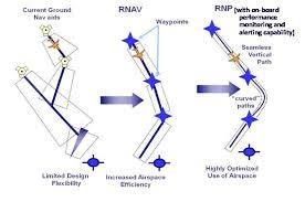
10 PBN Procedures Design Build anywhere 24-Aug-15 10


11 PBN Operational Hazard Build anywhere 24-Aug-15 11

12 AIM Roadmap Focus on going digital Focus on data and information quality management 24-Aug-15 12
13 etod Electronic Terrain and Obstacle Data Annex 15 specifies both collection and numerical requirements (resolution and integrity) Collection requirements may NOT provide a complete data set 24-Aug-15 13

14 etod using digital data 24-Aug-15 14
15 Terrain Definition The surface of the Earth containing naturally occurring features such as mountains, hills, ridges, valleys, bodies of water, permanent ice and snow and excluding obstacles 24-Aug-15 15
16 Terrain Features Bare Earth: surface of the Earth including bodies of water and permanent ice and snow and excluding vegetation's and man-made objects (culture) Canopy: bare Earth supplemented by vegetation height Culture: all man-made features constructed on the surface of the Earth, such as cities, railways and canals 24-Aug-15 16
17 Modeling Terrain Relief: the inequalities in elevation of the surface of the Earth represented on aeronautical charts by contours, hypsometric tints shading or spot elevations Post spacing: angular or linear distance between two adjacent elevation points 24-Aug-15 17

18 Digital Elevation Model (DEM) Representation of terrain surface by continuous elevation values at all intersections of a defined grid, referenced to common datum 24-Aug-15 18
19 DEM and Post Spacing 24-Aug-15 19
20 Using etod Understand the limitations etod collection requirements are specified minimums Areas overlap Not all obstacles may be reported Treat the identification of sources and the collection of obstacle data as a specific task on a PBN project 24-Aug-15 20

21 Digital Obstacle Data 24-Aug-15 21
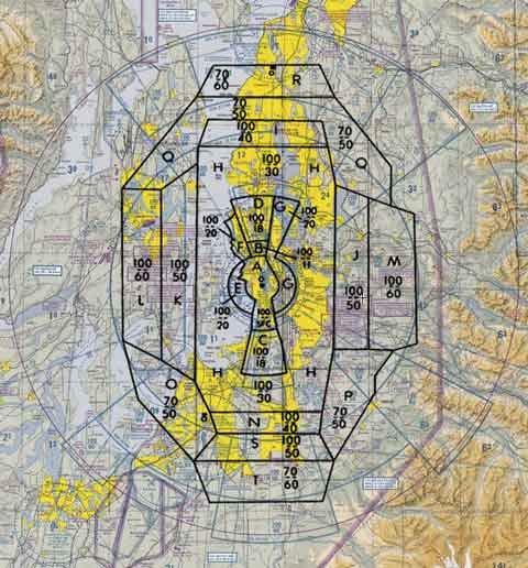
22 etod Areas Data collection requirements specified by area: Area 1 - The territory of the State ( The World ); Area 2 - The Terminal Airspace; Area 3 - The Aerodrome Movement Area; Area 4 - Precision Approach area 24-Aug-15 22
23 Obstacle Data Collection - Area 1 Area 1: Entire State territory Data on every obstacle within Area 1 whose height above the ground is 100 m or higher shall be collected and recorded in the database in accordance with the Area 1 numerical requirements. Coincides with WAC obstacle requirements Numerical requirements are specified Annex 15, Table A Aug-15 23

24 COVERAGE - AREA 2 Area 2a: a rectangular area around a runway that comprises the runway strip plus any clearway that exists. Area 2b: an area extending from the ends of Area 2a in the direction of departure, with a length of 10 km and a splay of 15% to each side. Area 2c: an area extending outside Area 2a and Area 2b at a distance of not more than 10 km from the boundary of Area 2a. 24-Aug-15 24
25 Obstacle data collection - Area 2 Obstacles within Area 2 that are assessed as being a hazard to air navigation; and Any object penetrating an aerodrome obstacle limitation surface(s) 24-Aug-15 25


26 Obstacle data collection - Area 2 Area 2a: Objects that penetrate a collection surface at a height of 3 m above the nearest runway elevation measured along the runway centre line, and for those portions related to a clearway, if one exists, at the elevation of the nearest runway end; Area 2b: Objects that penetrate a collection surface having a 1.2% slope extending from the ends of Area 2a at the elevation of the runway end in the direction of departure, with a length of 10 km and a splay of 15% to each side 24-Aug-15 26


27 Obstacle data collection - Area 2 (Recommended) The Area 2c: Objects that penetrate a surface having a 1.2% slope extending outside Area 2a and Area 2b at a distance of not more than 10 km from the boundary of Area 2a. The initial elevation of Area 2c shall be the elevation of the point of Area 2a at which it commences Area 2d: Objects that penetrate a collection surface having a height of 100 m above ground 24-Aug-15 27
28 Area 3 etod Areas (con t) Aerodrome also overlaps with Aerodrome Mapping Data (AMDB) From runway edge to movement areas Should originate from Aerodrome operator Area 4 Pre-threshold Requirements based on Precision Approach Terrain Chart (PATC) 24-Aug-15 28
29 etod Data Origination Area 1 Geodetic survey Obstacles are report or surveyed Area 2 Surveys by aerodromes and /or other agencies Obstacles are report or surveyed Area 3 Surveys by aerodromes Obstacles are reported by aerodrome Area 4 Aerodrome survey 24-Aug-15 29
30 etod issues Data acquisition is expensive Varying degrees of land use controls Not always clear who is responsible Difficult to relate the responsibility to collect ($$) with the benefit of use 24-Aug-15 30
31 Implementing etod Report additional obstacles to AIS/AIM Make for vision for data maintenance Originators Periodic survey Collect metadata Clarify responsibilities for verification Partner with AIS/AIM 24-Aug-15 31
32 WGS-84 ICAO standard since 1988 Implementation not 100% Essential for GNSS based procedures Actual status of implementation is not always clear 24-Aug-15 32


33 The Earth is Not Static Following earthquake activity the Mid-Atlantic Ridge (shown in Iceland) 24-Aug-15 33
")
34 Continental Drift Used with the kind permission of Jan-Philipp Lauer (DFS) 24-Aug-15 34
")
35 Tectonic Movement Zones Used with the kind permission of Jan-Philipp Lauer (DFS) 24-Aug-15 35

36 Survey Method Triangulation starting from known position Calculating new coordinates requires a reference system and datum 24-Aug-15 36
37 Understanding Coordinates Reference frame An abstract coordinate system and the set of physical reference points that uniquely fix (locate and orient) the coordinate system and standardize measurements. Datum a reference point or surface against which position measurements are made, and an associated model of the shape of the Earth for computing positions 24-Aug-15 37

38 The Earth is not perfect 24-Aug-15 38
39 Terrestrial Coordinate Reference International Terrestrial Reference System regional geodesic system Large earth-centred, earth-fixed NAD83, SAD69, ETRS89 Local reference systems usually referenced to some convenient local reference point 24-Aug-15 39

40 Position Shifts from Datum References 24-Aug-15 40
 24-Aug-15")
41 Terrestrial reference vs Space reference WGS84 coordinates anchored to earth s center of mass Terrestrial coordinates are anchored to the tectonic plate Continental drift about 2,5 cm per year Tectonic plate Used with the kind permission of Jan-Philipp Lauer (DFS) 24-Aug-15 41
42 Impact on PBN Navigation guidance use earth based facilities are less affected since all objects (incl. the antennas) drift in the same way However, database-dependent navigation technologies like PBN are affected The actual positions are slowly sliding away from the fixed waypoints defining the PBN procedures Regular re-surveying and coordinate transformations are necessary Expensive re-publication/approval of flight procedures may be required Used with the kind permission of Jan-Philipp Lauer (DFS) 24-Aug-15 42
43 What to do? Investigate and determine how coordinates are surveyed Derived (calculated) positions will be in the same reference coordinate system Document metadata concerning reference systems Unit of measurement Reference system used for the survey Epoch / referance date Don t make assumptions - verify 24-Aug-15 43
44 Summary Understand data sources AIM data quality management begins with the originator PBN is both an originator and a consumer of data The increasing application and integration of FMS requires robust and stringent data quality controls get it right the first time 24-Aug-15 44
45 Summary Metadata is a key enabler to good data management Not all coordinates are equal PBN quality management must be seamless with AIM QMS 24-Aug-15 45

46 Digital Data Enables Digital Design Tools 24-Aug-15 46
47
Chapter 1 Overview of Maps
 Chapter 1 Overview of Maps In this chapter you will learn about: Key points when working with maps General types of maps Incident specific maps Map legend and symbols Map sources A map is a navigational
Geodesy on the move. Craig Allinson. Dealing with dynamic coordinate reference systems. IOGP Geodesy Subcommittee. EPUG London, November 2017
 Geodesy on the move Dealing with dynamic coordinate reference systems Craig Allinson IOGP Geodesy Subcommittee EPUG London, November 2017 Why the concern? A bridge too far Historic geodesy mental image
SIRGAS: Basis for Geosciences, Geodata, and Navigation in Latin America
 SIRGAS: Basis for Geosciences, Geodata, and Navigation in Latin America Claudio Brunini President of SIRGAS Universidad Nacional de La Plata, Argentina María Virginia Mackern President of SIRGAS/WG-I:
Data Specification Elevation v3.0
 INSPIRE DS Highlights Data Specification Elevation v3.0 Jordi Escriu - TWG EL Editor Institut Cartogràfic de Catalunya (ICC) INSPIRE Conference 2012 Istanbul, 25 th - 27 th June 2012 1 This presentation
New Zealand Aeronautical Charting the ArcMap Challenge. Presenter: Beryl Pimblott Explorer Graphics Ltd
 New Zealand Aeronautical Charting the ArcMap Challenge Presenter: Beryl Pimblott Explorer Graphics Ltd Abstract This presentation will be on the production of a national series of Visual Navigation charts
Fundamentals of Surveying (LE/ESSE ) Lecture 10
 Lecture 10") Fundamentals of Surveying (LE/ESSE 2620 3.0) Lecture 10 Topographic Mapping Dr.-Ing. Jianguo Wang Geomatics Engineering York University Fall 2017 1 10-1 Introduction Two main types of maps: Line maps Orthophotographic
Fundamentals of Surveying (LE/ESSE 2620 3.0) Lecture 10 Topographic Mapping Dr.-Ing. Jianguo Wang Geomatics Engineering York University Fall 2017 1 10-1 Introduction Two main types of maps: Line maps Orthophotographic
Three-Dimensional Aerial Zoning around a Lebanese Airport
 Three-Dimensional Aerial Zoning around a Lebanese Airport Abstract by Oussama C. Jadayel and Rita Y. Ibrahim GIS Center, Faculty of Engineering, University of Balamand, P.O. Box: 100, Tripoli, LEBANON
SPOT DEM Product Description
 SPOT DEM Product Description Version 1.1 - May 1 st, 2004 This edition supersedes previous versions Acronyms DIMAP DTED DXF HRS JPEG, JPG DEM SRTM SVG Tiff - GeoTiff XML Digital Image MAP encapsulation
Introduction to GIS I
 Introduction to GIS Introduction How to answer geographical questions such as follows: What is the population of a particular city? What are the characteristics of the soils in a particular land parcel?
A map is a small-scale flat-surface representation of some portion of the earth s surface.
 MAPS AND CHARTS A map is a small-scale flat-surface representation of some portion of the earth s surface. A representation that is designed for plotting navigational information is called a chart. Often
Service improvement through integration of AIM, MET and ATM Information Services
 Service improvement through integration of AIM, MET and ATM Information Services B0-DATM EANPG COG AIM Task Force implementation practice Dr. Vadims Tumarkins Chairman of the EANPG COG AIM Task Force Head
The 3D Elevation Program: Overview. Jason Stoker USGS National Geospatial Program ESRI 2015 UC
 + The 3D Elevation Program: Overview Jason Stoker USGS National Geospatial Program ESRI 2015 UC + 2 A little history USGS has a long, proud tradition of mapmaking (2009) + 3 The changing times Mapping
ENGRG Introduction to GIS
 ENGRG 59910 Introduction to GIS Michael Piasecki March 17, 2014 Lecture 08: Terrain Analysis Outline: Terrain Analysis Earth Surface Representation Contour TIN Mass Points Digital Elevation Models Slope
Applying Hazard Maps to Urban Planning
 Applying Hazard Maps to Urban Planning September 10th, 2014 SAKAI Yuko Disaster Management Expert JICA Study Team for the Metro Cebu Roadmap Study on the Sustainable Urban Development 1 Contents 1. Outline
General Overview and Facts about the Irobland
 Using Geoinformation Science to Reveal the Impact of the Eritrea-Ethiopia Boundary Commission s Decision on Irobland and People By Alema Tesfaye, Washington DC, USA Part I General Overview and Facts about
Frames for the Future New Datum Definitions for Modernization of the U.S. National Spatial Reference System
 Figure 10. Horizontal position differences (in meters) between NAD 83 and ITRF 08 at time 2022.00 (January 1, 2022). Positional differences are shown for the North American and Pacific tectonic plates.
AIXM & WXXM Conference May th 2009 Importing and Exporting from Airport GIS Formats Day 3
 AIXM & WXXM Conference May 12-14 th 2009 Importing and Exporting from Airport GIS Formats Day 3 Dejan M. Damjanovic Director, Airport Mapping Database Programs Who are we, and what am I complaining about?
Positioning in the Pacific Islands
 Positioning in the Pacific Islands Andrick Lal United Nations/Nepal Workshop on the Applications of Global Navigation Satellite Systems Kathmandu - Nepal 15 th December 2016 Presentation Outline Introduction
Data Specification Elevation v2.0
 INSPIRE DS Stream Data Specification Elevation v2.0 Jordi Escriu Paradell - TWG EL Editor Institut Cartogràfic de Catalunya (ICC) INSPIRE Conference 2011 Edinburgh, 29 th June -1 st July 2011 1 This presentation
ROYAL CANADIAN AIR CADETS PROFICIENCY LEVEL FOUR INSTRUCTIONAL GUIDE SECTION 4 EO C USE A VISUAL FLIGHT RULES (VFR) NAVIGATION CHART (VNC)
 NAVIGATION CHART (VNC)") ROYAL CANADIAN AIR CADETS PROFICIENCY LEVEL FOUR INSTRUCTIONAL GUIDE SECTION 4 EO C437.02 USE A VISUAL FLIGHT RULES (VFR) NAVIGATION CHART (VNC) Total Time: 60 min PREPARATION PRE-LESSON INSTRUCTIONS Resources
ROYAL CANADIAN AIR CADETS PROFICIENCY LEVEL FOUR INSTRUCTIONAL GUIDE SECTION 4 EO C437.02 USE A VISUAL FLIGHT RULES (VFR) NAVIGATION CHART (VNC) Total Time: 60 min PREPARATION PRE-LESSON INSTRUCTIONS Resources
Area-wide geotechnical information summary for CERA zoning review panel
 Area-wide geotechnical information summary for CERA zoning review panel This document contains all the area-wide geotechnical information which was considered by CERA as part of the process for making
USGS Hydrography Overview. May 9, 2018
 + 1 USGS Hydrography Overview May 9, 2018 + 2 The National Geospatial Program Provides the geospatial baseline of the Nation s topography, natural landscape and built environment through The National Map,
HMK Swedish handbook in surveying and mapping
 HMK Swedish handbook in surveying and mapping A Alfredsson, J Sunna, C-G Persson TS07B - Standards and Recommended Practices for Positioning and Measurement, Paper no 7072 FIG Congress 2014 Engaging the
The Integration of Land and Marine Spatial Data Set As Part of Indonesian Spatial Data Infrastructure Development
 UNITED NATIONS E/CONF.97/6/IP. 46 ECONOMIC AND SOCIAL COUNCIL Seventeenth United Nations Regional Cartographic Conference for Asia and the Pacific Bangkok, 18-22 September 2006 Item 7 of the provisional
ENGRG Introduction to GIS
 ENGRG 59910 Introduction to GIS Michael Piasecki November 17, 2017 Lecture 11: Terrain Analysis Outline: Terrain Analysis Earth Surface Representation Contour TIN Mass Points Digital Elevation Models Slope
SPOT DEM Precision Product description
 SPOT DEM Precision Product description Version1.0 - April 1st, 2006 This edition supersedes previous versions Acronyms DIMAP DTED DXF HRS JPEG, JPG Mb DTM DEM SRTM SVG TIFF - GeoTIFF XML Digital Image
Area-wide geotechnical information summary for CERA zoning review panel
 Area-wide geotechnical information summary for CERA zoning review panel This document contains all the area-wide geotechnical information which was considered by CERA as part of the process for making
LESSON 2: INTRODUCTION TO TOPOGRAPHICAL MAPS
 LESSON 2: INTRODUCTION TO TOPOGRAPHICAL MAPS Finding your way if you become separated from a group. PURPOSE This lesson presents an overview of topographic maps. It describes their characteristics and
Ch 9.1 Notes. Objective: Be able to explain the theory of plate tectonics and be able to explain evidence that supports it.
 Ch 9.1 Notes Objective: Be able to explain the theory of plate tectonics and be able to explain evidence that supports it. Pangaea Alfred Wegener proposed that land on Earth formed a single, huge landmass.
Sea Floor Spreading Lab ES2 # 1 Purpose: Show rock age and magnetism patterns in spreading sea floor with a paper model.
 Names & B Date your name (first and last) partner Sea Floor Spreading Lab ES2 # 1 Purpose: Show rock age and magnetism patterns in spreading sea floor with a paper model. Background: In the last few decades,
Introduction. Elevation Data Strategy. Status and Next Steps
 1 2 Introduction Elevation Data Strategy Status and Next Steps 3 Canada is the 2nd largest country in the world - 9.9 million sq km Surrounded by 3 oceans with 202 000 km of coastline Population over 35
This presentation covers the following areas
 Geodetic Datums and Coordinate Systems for Surveying and Mapping in Hong Kong FIG Working Week 2012 Rome, Italy 6-10 May Simon KWOK Hong Kong, China 1 This presentation covers the following areas Explains
Area-wide geotechnical information summary for CERA zoning review panel
 Area-wide geotechnical information summary for CERA zoning review panel This document contains all the area-wide geotechnical information which was considered by CERA as part of the process for making
LiDAR Quality Assessment Report
 LiDAR Quality Assessment Report The USGS National Geospatial Technical Operations Center, Data Operations Branch is responsible for conducting reviews of all Light Detection and Ranging (LiDAR) pointcloud
Faatasi Malologa (PGSC Chair) Director Department of Lands & Survey, Tuvalu
 Director Department of Lands & Survey, Tuvalu") Seventh Session of the United Nations Committee of Experts on Global Geospatial Information Management (UN-GGIM) - 31 July -4 August 2017 Faatasi Malologa (PGSC Chair) Director Department of Lands & Survey,
Seventh Session of the United Nations Committee of Experts on Global Geospatial Information Management (UN-GGIM) - 31 July -4 August 2017 Faatasi Malologa (PGSC Chair) Director Department of Lands & Survey,
Earth and Space Science Semester 2 Exam Review. Part 1. - Convection currents circulate in the Asthenosphere located in the Upper Mantle.
 Earth and Space Science 2015 Semester 2 Exam Review Part 1 Convection -A form of heat transfer. - Convection currents circulate in the Asthenosphere located in the Upper Mantle. - Source of heat is from
Copyright 2016 Edmentum - All rights reserved.
 SI Quiz 14: Wk of Nov. 28 Copyright 2016 Edmentum - All rights reserved. Question #1 Two hundred and twenty-five million years ago, all of today's continents were part of a single continent known as Pangaea.
Evolving Meteorological Services for the Terminal Area
 Evolving Meteorological Services for the Terminal Area Towards an new participatory approach in ATM H. Puempel Chief, Aeronautical Meteorology Division Weather and Disaster Risk Reduction Dept. WMO The
GIS APPLICATIONS IN SOIL SURVEY UPDATES
 GIS APPLICATIONS IN SOIL SURVEY UPDATES ABSTRACT Recent computer hardware and GIS software developments provide new methods that can be used to update existing digital soil surveys. Multi-perspective visualization
Applying GIS Data to Radar Video Maps Air Traffic Control Towers
 Applying GIS Data to Radar Video Maps Air Traffic Control Towers National Aeronautical Charting Group (NACG) Silver Spring, MD Introduction Background Functions, History, Facts/Stats Mapping Environment
BUILDING AN ACCURATE GIS
 BUILDING AN ACCURATE GIS 2006 GIS in the Rockies Denver, Colorado September 13, 2006 William E. Linzey United States Department of Commerce National Oceanic and Atmospheric Administration National Geodetic
GeoWEPP Tutorial Appendix
 GeoWEPP Tutorial Appendix Chris S. Renschler University at Buffalo - The State University of New York Department of Geography, 116 Wilkeson Quad Buffalo, New York 14261, USA Prepared for use at the WEPP/GeoWEPP
Geographic Information Systems class # 1 February 19, Coordinate reference systems in GIS: geodetic coordinates
 Geographic Information Systems class # 1 February 19, 2013 Coordinate reference systems in GIS: geodetic coordinates Manuel Campagnolo ISA Manuel Campagnolo (ISA) GIS/SIG 2012 2013 February 19, 2013 1
Butte County Fire Department
 Butte County Fire Department Basic Land Navigation Verification Sheet I verify that Print Supervisor s name has completed the Print Employee s name Basic Land Navigation self study guide on. Date Attached
Land-Line Technical information leaflet
 Land-Line Technical information leaflet The product Land-Line is comprehensive and accurate large-scale digital mapping available for Great Britain. It comprises nearly 229 000 separate map tiles of data
8 th Grade Science Plate Tectonics and Topography Review
 8 th Grade Science Plate Tectonics and Topography Review #1 Scientists believe that the land masses of Earth were once joined together as one supercontinent called. A: Australia B: Wegner C: Pangaea D:
The Combination of Geospatial Data with Statistical Data for SDG Indicators
 Session x: Sustainable Development Goals, SDG indicators The Combination of Geospatial Data with Statistical Data for SDG Indicators Pier-Giorgio Zaccheddu Fabio Volpe 5-8 December2018, Nairobi IAEG SDG
Canadian Digital Elevation Data
 Natural Resources Canada Geomatics Canada Ressources naturelles Canada Géomatique Canada Canadian Digital Elevation Data Standards and Specifications Centre for Topographic Information Customer Support
Surveying I. Unit - I. Different methods and instruments are being used to facilitate the work of
 Surveying I Unit - I Definition of Survey Surveying is the art of determining the relative positions of different objects on the surface of the earth by measuring the horizontal distances between them,
Plate Tectonics: Continental Drift. Plate tectonics is a unifying theory that attempts to explain natural phenomena such as earthquakes and volcanoes.
 Plate Tectonics: Continental Drift Plate tectonics is a unifying theory that attempts to explain natural phenomena such as earthquakes and volcanoes. Continental Drift Review Alfred Wegener -1912 large
Popular Mechanics, 1954
 Introduction to GIS Popular Mechanics, 1954 1986 $2,599 1 MB of RAM 2017, $750, 128 GB memory, 2 GB of RAM Computing power has increased exponentially over the past 30 years, Allowing the existence of
MISSOURI LiDAR Stakeholders Meeting
 MISSOURI LiDAR Stakeholders Meeting East-West Gateway June 18, 2010 Tim Haithcoat Missouri GIO Enhanced Elevation Data What s different about it? Business requirements are changing.fast New data collection
The National Spatial Reference System of the Future
 The National Spatial Reference System of the Future William Stone Southwest Region (AZ, NM, NV, UT) Geodetic Advisor william.stone@noaa.gov NOAA s National Geodetic Survey geodesy.noaa.gov Salt Lake City
Submitted to. Prepared by
 Prepared by Tim Webster, PhD Candace MacDonald Applied Geomatics Research Group NSCC, Middleton Tel. 902 825 5475 email: tim.webster@nscc.ca Submitted to Harold MacNeil Engineering Manager Halifax Water
Area-wide geotechnical information summary for CERA zoning review panel
 Area-wide geotechnical information summary for CERA zoning review panel This document contains all the area-wide geotechnical information which was considered by CERA as part of the process for making
Topographic Maps and Landforms Geology Lab
 Topographic Maps and Landforms Geology Lab Ray Rector: Instructor Today s Lab Activities 1) Discussion of Last Week s Lab 2) Lecture on Topo Maps and Elevation Contours 3) Construct Topographic Maps and
GEODETIC NETWORK OF SAUDI ARABIA AND FIDUCIAL STATIONS. GFN OF Saudi Arabia in Based on ITRF2000 Datum
 STUDIES OF TECTONIC MOVEMENTS IN SAUDI ARABIA USING CORS M. Al Rajhi, Ali Al Omar, R. Yanar, F. Kartal, K. Eren, SUBJECT TO TALKS BACKGROUND GEODETIC NETWORK OF SAUDI ARABIA AND FIDUCIAL STATIONS GFN OF
Digital Elevation Models (DEM)
") Digital Elevation Models (DEM) Digital representation of the terrain surface enable 2.5 / 3D views Rule #1: they are models, not reality Rule #2: they always include some errors (subject to scale and data
Digital Elevation Models (DEM) Digital representation of the terrain surface enable 2.5 / 3D views Rule #1: they are models, not reality Rule #2: they always include some errors (subject to scale and data
UNIT 3 GEOLOGY VOCABULARY FLASHCARDS THESE KEY VOCABULARY WORDS AND PHRASES APPEAR ON THE UNIT 3 CBA
 UNIT 3 GEOLOGY VOCABULARY FLASHCARDS THESE KEY VOCABULARY WORDS AND PHRASES APPEAR ON THE UNIT 3 CBA A map that shows Earth s Topographic Map surface topography, which is Earth s shape and features Contour
LAND NAVIGATION 2-1. DEFINITION
 LAND NAVIGATION MAPS Cartography is the art and science of expressing the known physical features of the earth graphically by maps and charts. No one knows who drew, molded, laced together, or scratched
GGOS The Global Geodetic Observing System of the International Association of Geodesy
 GGOS The Global Geodetic Observing System of the International Association of Geodesy Presented at the FIG Working Week 2017, May 29 - June 2, 2017 in Helsinki, Finland Hansjörg Kutterer BKG, Germany Content
DRAPE 2014 Digital Elevation Model
 DRAPE 2014 Digital Elevation Model User Guide Spatial Data Infrastructure Mapping and Information Resources Branch Corporate Management and Information Division Ministry of Natural Resources and Forestry
USING THE MILITARY LENSATIC COMPASS
 USING THE MILITARY LENSATIC COMPASS WARNING This presentation is intended as a quick summary, and not a comprehensive resource. If you want to learn Land Navigation in detail, either buy a book; or get
GIS sources for terrain analyses
 8.5. 11.5.2018 GIS sources for terrain analyses major Ing. Josef Rada University of Defence Brno Czech Republic 1 Introduction - Project of VGHMÚř and University of Defence; - objective: search for the
ISO Swift Current LiDAR Project 2009 Data Product Specifications. Revision: A
 ISO 19131 Swift Current LiDAR Project 2009 Data Product Specifications Revision: A Data product specifications: Swift Current LiDAR Project 2009 - Table of Contents- 1. Overview... 4 1.1. Informal description...
The Lithosphere and the Tectonic System. The Structure of the Earth. Temperature 3000º ºC. Mantle
 The Lithosphere and the Tectonic System Objectives: Understand the structure of the planet Earth Review the geologic timescale as a point of reference for the history of the Earth Examine the major relief
PROANA A USEFUL SOFTWARE FOR TERRAIN ANALYSIS AND GEOENVIRONMENTAL APPLICATIONS STUDY CASE ON THE GEODYNAMIC EVOLUTION OF ARGOLIS PENINSULA, GREECE.
 PROANA A USEFUL SOFTWARE FOR TERRAIN ANALYSIS AND GEOENVIRONMENTAL APPLICATIONS STUDY CASE ON THE GEODYNAMIC EVOLUTION OF ARGOLIS PENINSULA, GREECE. Spyridoula Vassilopoulou * Institute of Cartography
The Impact of the 2010 Darfield (Canterbury) Earthquake on the Geodetic Infrastructure in New Zealand 1
 Earthquake on the Geodetic Infrastructure in New Zealand 1") The Impact of the 2010 Darfield (Canterbury) Earthquake on the Geodetic Infrastructure in New Zealand 1 Graeme BLICK, John BEAVAN, Chris CROOK, Nic DONNELLY Keywords: Darfield Earthquake, control, survey,
The Impact of the 2010 Darfield (Canterbury) Earthquake on the Geodetic Infrastructure in New Zealand 1 Graeme BLICK, John BEAVAN, Chris CROOK, Nic DONNELLY Keywords: Darfield Earthquake, control, survey,
CONTOUR MAPS This Enrichment4You e-guide provides a brief overview of contour maps In this e-guide you will: Sample file
 GEOLOGY CONTOUR MAPS CONTOUR MAPS This Enrichment4You e-guide provides a brief overview of contour maps In this e-guide you will: *Learn Basic Facts About Contour Maps *Make a 3-D Contour Map Geology Contour
Pan-Arctic Digital Elevation Map (Pan-Arctic DEM)
") Memorandum to CAFF Board 07/28/2017 BACKGROUND: Pan-Arctic Digital Elevation Map (Pan-Arctic DEM) ArcticDEM is a National Geospatial-Intelligence Agency (NGA)-National Science Foundation (NSF) publicprivate
Memorandum to CAFF Board 07/28/2017 BACKGROUND: Pan-Arctic Digital Elevation Map (Pan-Arctic DEM) ArcticDEM is a National Geospatial-Intelligence Agency (NGA)-National Science Foundation (NSF) publicprivate
Analysis of errors in the creation and updating of digital topographic maps
 GEODESY AND CARTOGRAPHY Vol. 67, No. 1, 2018, pp. 143 151 c Polish Academy of Sciences DOI: https://doi.org/10.24425/118703 Analysis of errors in the creation and updating of digital topographic maps Vera
1 Introduction / Background
 HSSC3-03C rev1 3 rd IHO-HSSC Meeting IHB, Monaco, 8-10 November 2011 Report to HSSC-3 by the Correspondence Group on Definition and Length of Coastline Submitted by: France Executive Summary: This paper
Dept. of Earth and Environmental Sciences, University of Waterloo, 200 University Ave W, Waterloo, Ontario, Canada, N2L 3G1 2
 A modelling strategy to develop a regional Quaternary geological model across rural and urban areas and administrative borders using existing geological information M. Ross 1, M. Parent 2, A. Taylor 1
IMS4 ARWIS. Airport Runway Weather Information System. Real-time data, forecasts and early warnings
 Airport Runway Weather Information System Real-time data, forecasts and early warnings Airport Runway Weather Information System FEATURES: Detection and prediction of runway conditions Alarms on hazardous
Sea Floor Spreading Lab ES2 # 2!
 Names & Bl Date your name (first and last) partner Sea Floor Spreading Lab ES2 # 2 Purpose: Show rock age and magnetism patterns in spreading sea floor with a paper model. Background: In the last few decades,
A Deformation Model to support a Next Generation Australian Geodetic Datum
 A Deformation Model to support a Next Generation Australian Geodetic Datum Richard Stanaway, Surveying and Geospatial Engineering School of Civil and Environmental Engineering multi-gnss + augmentation
CORS Network and Datum Harmonisation in the Asia-Pacific Region. Richard Stanaway and Craig Roberts
 CORS Network and Datum Harmonisation in the Asia-Pacific Region Richard Stanaway and Craig Roberts School of Surveying and Spatial Information Systems University of New South Wales CORS Networks in the
SECURITY REGULATED PORT BOUNDARY DESCRIPTION
 SECURITY REGULATED PORT BOUNDARY DESCRIPTION Description of State: Northern Territory Map Number: 68738 The Security Regulated is all of that area of land and water contained within and bounded by a line
Southwestern Ontario Orthophotography Project (SWOOP) 2015 Digital Elevation Model
 2015 Digital Elevation Model") Southwestern Ontario Orthophotography Project (SWOOP) 2015 Digital Elevation Model User Guide Provincial Mapping Unit Mapping and Information Resources Branch Corporate Management and Information Division
Southwestern Ontario Orthophotography Project (SWOOP) 2015 Digital Elevation Model User Guide Provincial Mapping Unit Mapping and Information Resources Branch Corporate Management and Information Division
Digital Topographic Map 1 : DTK1000
 Digital Topographic Map 1 : 1 DTK Documentation as of: 14.8.217 Federal Agency for Cartography and Geodesy DTK page 1 Digital Topographic Map 1 : 1 DTK Contents DTK Page 1 Index of data sets 3 2 Description
Building a 4-D Weather Data Cube for the NextGen Initial Operating Capability (IOC)
") Building a 4-D Weather Data Cube for the NextGen Initial Operating Capability (IOC) Friends/Partners in Aviation Weather Vision Forum July 15, 2008 Bruce Lambert - DoD Tom Ryan FAA Jason Tuell NWS 1 Overview
Building a 4-D Weather Data Cube for the NextGen Initial Operating Capability (IOC) Friends/Partners in Aviation Weather Vision Forum July 15, 2008 Bruce Lambert - DoD Tom Ryan FAA Jason Tuell NWS 1 Overview
A detailed description of the history, setup and performance of SGL s navigation and drape flying system is contained in reference [1].
![A detailed description of the history, setup and performance of SGL s navigation and drape flying system is contained in reference [1].](/thumbs/90/103916008.jpg "A detailed description of the history, setup and performance of SGL s navigation and drape flying system is contained in reference [1].") Pre-planned drape surfaces: a new survey planning tool Luise Sander* * Sander Geophysics Limited, 260 Hunt Club Road, Ottawa, Ontario, K1V 1C1 Originally presented at CSEG Forum: High Resolution Aeromagnetics
Pre-planned drape surfaces: a new survey planning tool Luise Sander* * Sander Geophysics Limited, 260 Hunt Club Road, Ottawa, Ontario, K1V 1C1 Originally presented at CSEG Forum: High Resolution Aeromagnetics
USGS Community Engagement and its Role in Improving The National Map
 USGS Community Engagement and its Role in Improving The National Map ESRI User Conference, 2014 Bob Davis Carol Ostergren Drew Decker USGS Strategic Direction Provides a sharpened focus on our topographic
EO Information Services. Assessing Vulnerability in the metropolitan area of Rio de Janeiro (Floods & Landslides) Project
 Project") EO Information Services in support of Assessing Vulnerability in the metropolitan area of Rio de Janeiro (Floods & Landslides) Project Ricardo Armas, Critical Software SA Haris Kontoes, ISARS NOA World
EO Information Services in support of Assessing Vulnerability in the metropolitan area of Rio de Janeiro (Floods & Landslides) Project Ricardo Armas, Critical Software SA Haris Kontoes, ISARS NOA World
The European Surveying Plot A surveying map of land property: A proposal and it s perspectives
 The European Surveying Plot A surveying map of land property: A proposal and it s perspectives Nikolaos KALAMAKIS, Greece Key words: INSPIRE, Interoperability, National Geographic Organizations, technical
ANNEX 23 RESOLUTION MSC.231(82) ADOPTION OF AMENDMENTS TO THE EXISTING MANDATORY SHIP REPORTING SYSTEM IN THE GULF OF FINLAND
 ADOPTION OF AMENDMENTS TO THE EXISTING MANDATORY SHIP REPORTING SYSTEM IN THE GULF OF FINLAND") RESOLUTION MSC.231(82) (adopted on 5 December 2006) ADOPTION OF AMENDMENTS TO THE EXISTING MANDATORY SHIP REPORTING SYSTEM IN THE GULF OF FINLAND THE MARITIME SAFETY COMMITTEE, RECALLING Article 28(b)
RESOLUTION MSC.231(82) (adopted on 5 December 2006) ADOPTION OF AMENDMENTS TO THE EXISTING MANDATORY SHIP REPORTING SYSTEM IN THE GULF OF FINLAND THE MARITIME SAFETY COMMITTEE, RECALLING Article 28(b)
Remote Sensing / GIS Conference. The Louisiana Proposed Elevation for the Nation Business Plan Components
 Remote Sensing / GIS Conference 08 April 2008 The Louisiana Proposed Elevation for the Nation Business Plan Components David Gisclair, Louisiana Oil Spill Coordinators Office, Office of the Governor david.gisclair@la.gov
A METHODOLOGY FOR ASSESSING EARTHQUAKE-INDUCED LANDSLIDE RISK. Agency for the Environmental Protection, ITALY (
 A METHODOLOGY FOR ASSESSING EARTHQUAKE-INDUCED LANDSLIDE RISK Roberto W. Romeo 1, Randall W. Jibson 2 & Antonio Pugliese 3 1 University of Urbino, ITALY (e-mail: rwromeo@uniurb.it) 2 U.S. Geological Survey
HORIZONTAL PROJECTION PARAMETERS: DANE COUNTY COORDINATES
 Recommended RTK GPS Configuration Parameters for the City of Madison, WI Base Station Compiled by: Dan Rodman RLS, City of Madison (608)266-6674 drodman@cityofmadison.com For base station information see
Geodesy. orientation. shape. gravity field
 Geodesy noun Science of measuring the shape, orientation and gravity field of the Earth and how it changes over time. shape orientation gravity field Positioning has always been important Downstream applications
Reference frames and positioning
 The APREF Project: an Improved Geodetic Infrastructure for Asia and the Pacific (4861) John Dawson (Australia), Graeme Blick (New Zealand), Manoj Deo, Guorong Hu and Gary Johnston (Australia) Reference
This week s topics. Week 6. FE 257. GIS and Forest Engineering Applications. Week 6
 FE 257. GIS and Forest Engineering Applications Week 6 Week 6 Last week Chapter 8 Combining and splitting landscape features and merging GIS databases Chapter 11 Overlay processes Questions? Next week
Positional Accuracy of the Google Earth Imagery In The Gaza Strip
 Positional Accuracy of the Google Earth Imagery In The Gaza Strip Maher A. El-Hallaq Associate Professor of Surveying Civil Engineering Department The Islamic University of Gaza, Palestine mhallaq@iugaza.edu.ps
Positioning the Pacific: NOAA s Geospatial Activities. Juliana Blackwell, Director NOAA s National Geodetic Survey March 6, 2012
 Positioning the Pacific: NOAA s Geospatial Activities Juliana Blackwell, Director NOAA s National Geodetic Survey March 6, 2012 A Common Problem of the Early 19 th Century 1807 President Thomas Jefferson
Aviation Weather. Segment Three - Concept of Operations and Requirements. Federal Aviation Administration
 Aviation Weather Segment Three - Concept of Operations and Requirements Presented to: Panel: Friends/Partners in Aviation Weather Vision Forum Richard Heuwinkel, Kevin Johnston, Leo Prusak, and Joe Sherry
Increasing GI awareness in local authorities in Poland experiences from the INSPIRE Academy training programme
 Increasing GI awareness in local authorities in Poland experiences from the INSPIRE Academy training programme http://www.akademiainspire.pl Maria Andrzejewska, Monika Rusztecka UNEP/GRID-Warsaw Centre,
The Basics The lithosphere is made up of numerous plates (14 major, 38 minor)
") The Basics The lithosphere is made up of numerous plates (14 major, 38 minor) These plates float atop the asthenosphere, where they can move (albeit very slowly) Plate tectonics describes the formation,
The Basics The lithosphere is made up of numerous plates (14 major, 38 minor) These plates float atop the asthenosphere, where they can move (albeit very slowly) Plate tectonics describes the formation,
Brazil Paper for the. Second Preparatory Meeting of the Proposed United Nations Committee of Experts on Global Geographic Information Management
 Brazil Paper for the Second Preparatory Meeting of the Proposed United Nations Committee of Experts on Global Geographic Information Management on Data Integration Introduction The quick development of
Key Processes
 Data Manipulation and Extraction Key Processes Key Processes Re-Projecting Data Selecting by Attributes Exporting Data Hillshade Reclassification Conversion of Raster to Vector Re-Projecting Data Purpose
AERODROMES PANEL (AP) VISUAL AIDS WORKING GROUP (VAWG) FIFTH MEETING. Montréal, Canada, 25 to 27 June 2008
 VISUAL AIDS WORKING GROUP (VAWG) FIFTH MEETING. Montréal, Canada, 25 to 27 June 2008") VAWG/5-DP/18 25/6/08 AERODROMES PANEL (AP) VISUAL AIDS WORKING GROUP (VAWG) FIFTH MEETING Montréal, Canada, 25 to 27 June 2008 Agenda Item 11: Any other business NEW TECHNOLOGIES FOR HIGH PRECISION PAPI
VAWG/5-DP/18 25/6/08 AERODROMES PANEL (AP) VISUAL AIDS WORKING GROUP (VAWG) FIFTH MEETING Montréal, Canada, 25 to 27 June 2008 Agenda Item 11: Any other business NEW TECHNOLOGIES FOR HIGH PRECISION PAPI