Dr.ing.Iulian Nichersu, Dr. Ing. Iuliana Nichersu 1
|
|
|
- Hilda Parker
- 5 years ago
- Views:
Transcription
1 Dr.ing.Iulian Nichersu, Dr. Ing. Iuliana Nichersu 1

2


3 Biodiversity Research Maliuc 1. Environmental Impact Assessment 2. Inventory & monitoring of biodiversity (habitats, plants, invertebrates, vertebrates) 3. Birds Monitoring & Telemetry 4. Studying Bird Migration, 5. Colonies of aquatic birds, 6. UAV (drone) 7. Species game & hunting 8. Dissemination, teaching awareness,


 and ticks (Ixodidae) 16.")
4 Biodiversity Research Maliuc 9. Management Plan Elaboration, 10. Monitoring of biodiversity before, during and after ecological reconstruction 11. Conservation Activities 12. Pilot projects for the Flag Species: steppe viper, white stork, white-tailed eagle, the European mink, etc., 13. Monitoring of new species / alien species (dwarf acacia, Amur Gobies, Eurasian beaver / Beaver, tree marten etc.) 14. Mosquitoes (Culicidae) and ticks (Ixodidae) 16. Impact assessment of fish eating birds, 16. Ecological Needs study of biodiversity 17. Natura 2000.


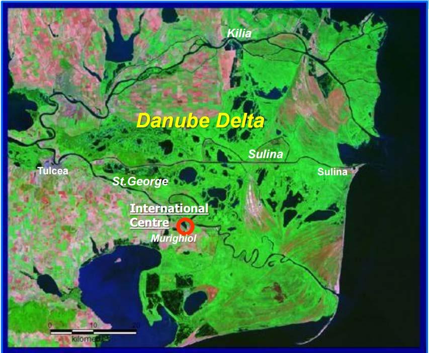
5 Biodiversity Research Maliuc


6 Lower Danube and Danube Delta CASE STUDY
7 The Danube River Basin Management Plan (2009) concluded that 93% of the Danube River is at risk or possibly at risk of failing WFD due to hydro morphological alteration and 80% of the Danube River Basin District s (DRBD) former wetlands/floodplains are disconnected, largely for agricultural uses and river engineering works for flood control, navigation and power generation. In response, in the Lower Danube Floodplain, Romanian Ministry of Environment proposed an adaptation scenario for climate and land-use change (REELD).


8 11/4/2016 DANUBE DELTA NATIONAL INSTITUTE TULCEA * ROMANIA 8

9 4D Connectivity in a river ecosystem ( ) 11/4/2016 DANUBE DELTA NATIONAL INSTITUTE TULCEA * ROMANIA 9

10 Danube complex HGM system 11/4/2016 DANUBE DELTA NATIONAL INSTITUTE TULCEA * ROMANIA 10


11 Sfantu Gheorghe Branch- Danube Delta CASE STUDY


12


13
 Aprilie")
14 Delta Dunării are sute de fețe pe parcursul unui an (Harta nivelurilor în Aprilie și în sezonul uscat- August) Aprilie August
 Rast Village - 23 rd")
15 New defense lines against floods (rings dykes) Rast Village - 23 rd June 2006

16 Ecological and Economical Resizing in Lower Danube (REELD) Floods Management and Ecological Restoration Win-Win Scenario
17
18 WP5. Data Collection Data base Structure Danube River Cross-sections DTM LIDAR data Topographic maps Roughness coefficient (CLC 2006) Q,H daily values hydrometric stations Satellite images Modeling 1D2D (Sobek) Hazard maps


19 Danube River Cross-sections - Bathymetric points (X,Y,Z Stereo70, MN75) - Additional points from LIDAR data and topographic maps(x,y,z Stereo70, MN75)

 Number of cross-sections")
20 Danube River Cross-sections Cross-sections between dikes (distance between cross-sections 100 m) Number of cross-sections : >

21 Roughness coefficient (CLC 2006) CLC classes - 31x forest - 32x grassland - 41x swamp - 5xx water -. Manning coefficient


22 Q,H daily values hydrometric stations

 h -")
 Processing")
23 LIDAR data Digital Terrain Model DTM α - h - OVERLAP - 2 tan(α/2) h - Available data (fly 2007) Processing data (fly 2010)

24 DTM final Dikes gaps channels Cross sections
 Dike 2D")
25 WP6. Hazard maps Flooding border 2D Model Dike 1D Model 1D coupled with 2D model (Sobek) Dike 2D Model

 1D")
26 2D model 1D coupled with 2D model (Sobek) 1D model


27 HAZARD MAPS DEPTH 10 years 100 years 1000 years

28 HAZARD MAPS EXTEND


29 UAS-BIRDD The main objective is to identify and quantify the dinamics of Hydro-Geo- Morphological system in D.D.B.R. using U.A.V. techniques a non-invasive method of investigation and integration of data collected in a GIS database and to analyze information correlated with habitat characteristics (elevation, vegetation cover, water level) Unmanned Aerial Vehicle (UAV) an unmanned aircraft on board: Platform: airframe, propulsion system, control system aircraft navigation system; Payload: electro-optical detection systems, infrared systems, etc.; Ground Control Station: monitoring display flight communication systems.


30 Danube Flood Peak Effects a/ Restoration 0.24 m 0.26 m 0.20 m 0.25 m 0.25 m 0.25 m 1.27 m 0.54 m 0.58 m 0.32 m 0.95 m 0.17 m 0.08 m b/ Restoration+Water Sorage Basins


31


32 Before all, must seek, through our work to be able to put a value of this area as more of this land and not leave areas so large between bank and dyke, to be condemned to remain unproductive, except of course the areas that are strictly necessary for water flow during large flood. This can not be achieved, in another way than creating in the edge of the river from a distance to distance a series of basins, besides permanent wetlands, that we have shown that preserved and arranged, which alternate with land reserved for agriculture and were the river water can flood.
; 15.")
33 According to existing data and hydraulic scenarios drawn up on the surface of the total embanked precincts of the Danube Floodplain - 445,000 ha, results 3 categories of use in the future: 43.3% for the remaining precincts for agriculture; 40.8% areas used as mixed (agricultural / polders and water storage); 15.9% areas for renaturation to create wetlands.
34 Participatory Perspective Interactive Scenarios Problems Identification + Possible solution Spatial Planning modelsvisualization of system evolution (CONSIDEO) Evaluation of problems Scenarios with solutions (CIB) Cumulative Solutions Assessment Gridification of solutions NPV i = rate deduction Ecological footprint- Natural Capital Cost/solution analyze LOGICAL FRAMEWORK FROM PARTICIPATORY PERSPECTIVE TO INTERACTIVE SCENARIOS


35 HAZARD & RISK MAPS SKETCH MATCH APPROACH SPATIAL PLANNING INTEGRATION SPATIAL DEVELOPMENT


36 Conclusions UAV is a valuable tool that can examine and describe hydro morphology in wetlands needs for ecological restoration. The application of UAV provides a methodological contribution and quantitative analysis to drill first the relationship between geomorphological processes and the degree of convolution of the arm and can thus develop scenarios of its development. Correlation of the flow dynamics with the variation of climate which still gives headaches to the researchers can be demonstrated and modeled by UAV technology. This quality can transform in the very important decision support instrument in vulnerability neighboring areas. The ecological restoration need data of the natural state and UAV using is also confirmed by analysis and comparing the three temporal stages (analysis Hartley's Map 1870, orthophotomap 2011 and shortterm scenario).


37 Agenţia Europeană Spaţială
38 Thank you for your attention! Dr. Eng. Iulian Nichersu Dr. Eng. Iuliana Nichersu
Danube Sediment Management Restoration of Sediment Balance in the Danube A still ongoing project preparation
 Annual Steakholder Seminar Protecting the Environment EU SDR Budapest, 6 November, 2012 Danube Sediment Management Restoration of Sediment Balance in the Danube A still ongoing project preparation Values
Integrated methodology for assessing the effects of geomorphological river restoration on fish habitat and riparian vegetation
 Integrated methodology for assessing the effects of geomorphological river restoration on fish habitat and riparian vegetation Judit Maroto *a, Miguel Marchamalo a,b, Diego García de Jalón a, Marta González
Improvement of navigation conditions on the Danube (Calarasi-Braila and Lower Danube) - Ecological concerns?
 - Ecological concerns?") Improvement of navigation conditions on the Danube (Calarasi-Braila and Lower Danube) - Ecological concerns? Georg Rast, Christine Bratrich, Orieta Hulea WWF Germany/DCPO Topics of the presentation Major
Improvement of navigation conditions on the Danube (Calarasi-Braila and Lower Danube) - Ecological concerns? Georg Rast, Christine Bratrich, Orieta Hulea WWF Germany/DCPO Topics of the presentation Major
The Use of Higher-Resolution Satellite Imagery, LiDAR and Drones in River Applications:
 The Use of Higher-Resolution Satellite Imagery, LiDAR and Drones in River Applications: Meander Belt Width Assessments to Effluent Plume Delineation Joanna Eyquem, P.Geo., Principal Fluvial Geomorphology,
Restoring river-floodplain interconnection and riparian habitats along the embanked Danube between Neuburg and Ingolstadt (Germany)
") Restoring river-floodplain interconnection and riparian habitats along the embanked Danube between Neuburg and Ingolstadt (Germany) Dipl.-Geogr. Gerald Blasch Department of Physical Geography, Cath. University
Restoring river-floodplain interconnection and riparian habitats along the embanked Danube between Neuburg and Ingolstadt (Germany) Dipl.-Geogr. Gerald Blasch Department of Physical Geography, Cath. University
GEOMATICS. Shaping our world. A company of
 GEOMATICS Shaping our world A company of OUR EXPERTISE Geomatics Geomatics plays a mayor role in hydropower, land and water resources, urban development, transport & mobility, renewable energy, and infrastructure
Mississippi River and Tributaries Project Mississippi River Geomorphology and Potamology Program
 Mississippi River and Tributaries Project Mississippi River Geomorphology and Potamology Program Barb Kleiss, Mississippi Valley Division Freddie Pinkard, Vicksburg District June, 2016 Program Objectives
Flood protection structure detection with Lidar: examples on French Mediterranean rivers and coastal areas
 Flood protection structure detection with Lidar: examples on French Mediterranean rivers and coastal areas Céline Trmal 1,a, Frédéric Pons 1 and Patrick Ledoux 1 1 Cerema, Direction Territoriale Méditerranée,
USING GIS CARTOGRAPHIC MODELING TO ANALYSIS SPATIAL DISTRIBUTION OF LANDSLIDE SENSITIVE AREAS IN YANGMINGSHAN NATIONAL PARK, TAIWAN
 CO-145 USING GIS CARTOGRAPHIC MODELING TO ANALYSIS SPATIAL DISTRIBUTION OF LANDSLIDE SENSITIVE AREAS IN YANGMINGSHAN NATIONAL PARK, TAIWAN DING Y.C. Chinese Culture University., TAIPEI, TAIWAN, PROVINCE
Applying Hazard Maps to Urban Planning
 Applying Hazard Maps to Urban Planning September 10th, 2014 SAKAI Yuko Disaster Management Expert JICA Study Team for the Metro Cebu Roadmap Study on the Sustainable Urban Development 1 Contents 1. Outline
Kootenai River Habitat Restoration Program Update
 Kootenai River Habitat Restoration Program Update Kootenai Tribe of Idaho Kootenai Valley Resource Initiative November 19, 2012 Bonners Ferry, Idaho Changes to Kootenai Basin Beaver trapping Floodplain
A SIMPLE GIS METHOD FOR OBTAINING FLOODED AREAS
 A SIMPLE GIS METHOD FOR OBTAINING FLOODED AREAS ROMAN P., I. 1, OROS C., R. 2 ABSTRACT. A simple GIS method for obtaining flooded areas. This paper presents a method for obtaining flooded areas near to
Landslide Hazard Assessment Methodologies in Romania
 A Scientific Network for Earthquake, Landslide and Flood Hazard Prevention SciNet NatHazPrev Landslide Hazard Assessment Methodologies in Romania In the literature the terms of susceptibility and landslide
National Disaster Management Centre (NDMC) Republic of Maldives. Location
 Republic of Maldives. Location") National Disaster Management Centre (NDMC) Republic of Maldives Location Country Profile 1,190 islands. 198 Inhabited Islands. Total land area 300 sq km Islands range b/w 0.2 5 sq km Population approx.
National Disaster Management Centre (NDMC) Republic of Maldives Location Country Profile 1,190 islands. 198 Inhabited Islands. Total land area 300 sq km Islands range b/w 0.2 5 sq km Population approx.
Technical Drafting, Geographic Information Systems and Computer- Based Cartography
 Technical Drafting, Geographic Information Systems and Computer- Based Cartography Project-Specific and Regional Resource Mapping Services Geographic Information Systems - Spatial Analysis Terrestrial
Geospatial workflows and potential applications to the Sustainable Development Goals of countries in West Asia
 Geospatial workflows and potential applications to the Sustainable Development Goals of countries in West Asia Ameer Abdulla, PhD Senior Advisor, European Topic Center for Spatial Analysis, Spain Associate
Remote Sensing for Ecosystems
 MODULE GUIDE MSc ENR Remote Sensing for Ecosystems Semester 01 Modul coordinator Lecturers Michael Döring Pascal Ochsner, Diego Tonolla, Diane Whited, Michael Döring Martin Geilhausen Latest update August
Flow regime, floodplain inundation and floodplain waterbody connectivity at Congaree National Park
 Flow regime, floodplain inundation and floodplain waterbody connectivity at Congaree National Park John Kupfer Dept. of Geography Univ. of South Carolina Kimberly Meitzen Duke University Nature Conservancy
Lidar data in water resources applications. Paola Passalacqua CE 374K Lecture, April 5 th, 2012
 Lidar data in water resources applications Paola Passalacqua CE 374K Lecture, April 5 th, 2012 Airborne Lidar Airborne laser altimetry technology (LiDAR, Light Detection And Ranging) provides high-resolution
European Topic Centre on Land Urban and Soil Systems. Green Infrastructure at EEA
 Green Infrastructure at EEA A SPATIAL APPROACH TO MAPPING GI Stefan Kleeschulte, ETC ULS GI and territorial cohesion 2011 first EEA report on Green Infrastructure Underlining the need to develop tools
Vulnerability of Flood Hazard in Selected Ayeyarwady Delta Region, Myanmar
 Vulnerability of Flood Hazard in Selected Ayeyarwady Delta Region, Myanmar Khin Thandar Win Department of Civil Engineering Nilar Aye Department of Civil Engineering Kyaw Zaya Htun Department of Remote
Quick Response Report #126 Hurricane Floyd Flood Mapping Integrating Landsat 7 TM Satellite Imagery and DEM Data
 Quick Response Report #126 Hurricane Floyd Flood Mapping Integrating Landsat 7 TM Satellite Imagery and DEM Data Jeffrey D. Colby Yong Wang Karen Mulcahy Department of Geography East Carolina University
Lower South Fork McKenzie River Floodplain Enhancement Project
 Lower South Fork McKenzie River Floodplain Enhancement Project McKenzie River Ranger District Willamette National Forest Project Location The project is located in the South Fork McKenzie River Watershed,
MAPPING THE FLASH FLOOD PRONE AREA IN THE TAITA WATERSHED (ROMANIA) USING TOPOGRAPHIC INDEXES AND HYDRAULIC MODEL
 USING TOPOGRAPHIC INDEXES AND HYDRAULIC MODEL") ICNAR 2014 MAPPING THE FLASH FLOOD PRONE AREA IN THE TAITA WATERSHED (ROMANIA) USING TOPOGRAPHIC INDEXES AND HYDRAULIC MODEL C. Maftei K. Papatheodorou Outline Research context Research objective Research
ICNAR 2014 MAPPING THE FLASH FLOOD PRONE AREA IN THE TAITA WATERSHED (ROMANIA) USING TOPOGRAPHIC INDEXES AND HYDRAULIC MODEL C. Maftei K. Papatheodorou Outline Research context Research objective Research
Opportunities to Improve Ecological Functions of Floodplains and Reduce Flood Risk along Major Rivers in the Puget Sound Basin
 Opportunities to Improve Ecological Functions of Floodplains and Reduce Flood Risk along Major Rivers in the Puget Sound Basin Christopher Konrad, US Geological Survey Tim Beechie, NOAA Fisheries Managing
Modeling Great Britain s Flood Defenses. Flood Defense in Great Britain. By Dr. Yizhong Qu
 Modeling Great Britain s Flood Defenses AIRCurrents Editor s note: AIR launched its Inland Flood Model for Great Britain in December 2008. The hazard module captures the physical processes of rainfall-runoff
South Florida Coastal Storm Surge and Mapping Study
 South Florida Coastal Storm Surge and Mapping Study Presented by Christopher Bender, Ph.D., P.E., D.CE June 2, 2015 Presentation Overview FEMA risk studies outline Overview South Florida surge study Work
Krešimir Žganec, doc. dr. sc. University of Zadar
 Krešimir Žganec, doc. dr. sc. University of Zadar Project aim: highlight the most outstanding freshwater/river ecosystems in Serbia Expected results: A map showing the most outstanding freshwater ecosystems
Floodplain Modeling and Mapping Using The Geographical Information Systems (GIS) and Hec-RAS/Hec-GeoRAS Applications. Case of Edirne, Turkey.
 and Hec-RAS/Hec-GeoRAS Applications. Case of Edirne, Turkey.") Floodplain Modeling and Mapping Using The Geographical Information Systems (GIS) and Hec-RAS/Hec-GeoRAS Applications. Case of Edirne, Turkey. Fuad Hajibayov *1, Basak Demires Ozkul 1, Fatih Terzi 1 1 Istanbul
Floodplain Modeling and Mapping Using The Geographical Information Systems (GIS) and Hec-RAS/Hec-GeoRAS Applications. Case of Edirne, Turkey. Fuad Hajibayov *1, Basak Demires Ozkul 1, Fatih Terzi 1 1 Istanbul
Hydrologic Analysis for Ecosystem Restoration
 Hydrologic Analysis for Ecosystem Restoration Davis, California Objectives: To provide participants with: 1) an understanding of the issues in restoration studies; 2) an overview of Corps policies and
MARSPLAN-BS NEWSLETTER
 MARSPLAN-BS NEWSLETTER MARSPLAN-BS Consortium March 2017 In this issue: Cross Border Maritime Spatial Planning in the Black Sea Romania and Bulgaria (MARSPLAN-BS) Echoes from recent events 8 th Thematic
WORKSHOP #2 [Modeling and Sediment Transfers Review of alternative solutions] Bucharest 07 October 2015
![WORKSHOP #2 [Modeling and Sediment Transfers Review of alternative solutions] Bucharest 07 October 2015](/thumbs/82/85703998.jpg "WORKSHOP #2 [Modeling and Sediment Transfers Review of alternative solutions] Bucharest 07 October 2015") STUDIU DE FEZABILITATE PENTRU SOLUŢII TEHNICE ALTERNATIVE/COMPLEMENTARE PRIVIND LUCRĂRILE CE SE VOR EXECUTA ÎN PUNCTUL CRITIC 01 BALA DIN CADRUL PROIECTULUI ÎMBUNĂTĂŢIREA CONDIŢIILOR DE NAVIGAŢIE PE DUNĂRE
STUDIU DE FEZABILITATE PENTRU SOLUŢII TEHNICE ALTERNATIVE/COMPLEMENTARE PRIVIND LUCRĂRILE CE SE VOR EXECUTA ÎN PUNCTUL CRITIC 01 BALA DIN CADRUL PROIECTULUI ÎMBUNĂTĂŢIREA CONDIŢIILOR DE NAVIGAŢIE PE DUNĂRE
Use of Geospatial data for disaster managements
 Use of Geospatial data for disaster managements Source: http://alertsystemsgroup.com Instructor : Professor Dr. Yuji Murayama Teaching Assistant : Manjula Ranagalage What is GIS? A powerful set of tools
EAGLES NEST AND PIASA ISLANDS
 EAGLES NEST AND PIASA ISLANDS HABITAT REHABILITATION AND ENHANCEMENT PROJECT MADISON AND JERSEY COUNTIES, ILLINOIS ENVIRONMENTAL MANAGEMENT PROGRAM ST. LOUIS DISTRICT FACT SHEET I. LOCATION The proposed
Land Accounts - The Canadian Experience
 Land Accounts - The Canadian Experience Development of a Geospatial database to measure the effect of human activity on the environment Who is doing Land Accounts Statistics Canada (national) Component
Sediment management: a european perspective. Piet den Besten Centre for Water Management Rijkswaterstaat, Netherlands
 Sediment management: a european perspective Piet den Besten Centre for Water Management Rijkswaterstaat, Netherlands Content Background of Dutch-German exchange (DGE plus) What is needed for adequate sediment
Birch Creek Geomorphic Assessment and Action Plan
 Birch Creek Geomorphic Assessment and Action Plan Jim Webster Tim Hanrahan, PhD, CFM Jesse Schwartz, PhD Zach Hill January 22, 2015 White Eagle Grange This Project is a First Step in Strategy Planning
Department of Geography: Vivekananda College for Women. Barisha, Kolkata-8. Syllabus of Post graduate Course in Geography
 India: Regional Problems and Resource management Module 11 (Full Marks 50) Unit I: Region and Regionalisation 1.1 Various bases of regionalisation of India; problems of identification and delineation.
LAND COVER CHANGES IN ROMANIA BASED ON CORINE LAND COVER INVENTORY
 LAND COVER CHANGES IN ROMANIA BASED ON CORINE LAND COVER INVENTORY 1990 2012 JENICĂ HANGANU, ADRIAN CONSTANTINESCU * Key-words: CORINE Land Cover inventory, Land cover changes, GIS. Abstract. From 1990
Delimiting Freedom Space for Rivers Using GIS and Remote Sensing:
 Delimiting Freedom Space for Rivers Using GIS and Remote Sensing: Updating existing tools to manage functional and resilient river systems Joanna Eyquem and Fabien Hugue (AECOM) Pascale Biron (University
Spanish national plan for land observation: new collaborative production system in Europe
 ADVANCE UNEDITED VERSION UNITED NATIONS E/CONF.103/5/Add.1 Economic and Social Affairs 9 July 2013 Tenth United Nations Regional Cartographic Conference for the Americas New York, 19-23, August 2013 Item
Land accounting in Québec: Pilot project for a sub-provincial area
 Land accounting in Québec: Pilot project for a sub-provincial area Stéphanie Uhde 8th meeting of the London Group on Environmental Accounting Ottawa, 2 October, 2012 Province of Québec Area: 1 667 441
DANUBEparksCONNECTED WP 3 WILDisland
 DANUBEparksCONNECTED WP 3 WILDisland Towards a Danube Wild Island Habitat Corridor WP responsible partner: Duna Ipoly National Park Total Budget: 680.959,20 Act. 3.1: Danube WILDisland learning process
1.1 What is Site Fingerprinting?
 Site Fingerprinting Utilizing GIS/GPS Technology 1.1 What is Site Fingerprinting? Site fingerprinting is a planning tool used to design communities where protection of natural resources is the primary
Removal of riverbank protection along the River Rhine (the Netherlands)
") RR 2004 3rd European Conference on River Restoration RIVER RESTORATION 2004 Zagreb, Croatia, 17-21 May 2004 Removal of riverbank protection along the River Rhine (the Netherlands) L.J. Bolwidt, H.E.J.
RR 2004 3rd European Conference on River Restoration RIVER RESTORATION 2004 Zagreb, Croatia, 17-21 May 2004 Removal of riverbank protection along the River Rhine (the Netherlands) L.J. Bolwidt, H.E.J.
SusWater WP6 Status desember 2017
 SusWater WP6 Status desember 2017 Mesohabitater / strømningstyper Elvetyper Workshops Leveranser WP6 Forsker-workshops Nordisk vannforvaltning EU WFD Ad-hoc task force HyMo Notater og rapporter Test av
Landslide hazard assessment in the Khelvachauri area, Georgia
 Report on the project of AES Geohazards Stream Landslide hazard assessment in the Khelvachauri area, Georgia May 2010 George Jianping Panisara Gaprindashvili Guo Daorueang Institute of Geo-Information
Solutions to Flooding on Pescadero Creek Road
 Hydrology Hydraulics Geomorphology Design Field Services Photo courtesy Half Moon Bay Review Solutions to Flooding on Pescadero Creek Road Prepared for: San Mateo County Resource Conservation District
Resolution XIII.23. Wetlands in the Arctic and sub-arctic
 13th Meeting of the Conference of the Contracting Parties to the Ramsar Convention on Wetlands Wetlands for a Sustainable Urban Future Dubai, United Arab Emirates, 21-29 October 2018 Resolution XIII.23
Overview of Methods. Terrestrial areas that are most important for conservation Conservation
 Overview of Methods The goal of the Western Lake Erie Coastal Conservation Vision project (WLECCV) is to define where we should be working locally to optimally achieve regional conservation impact. The
EBRO DELTA WORK PLAN
 EBRO DELTA Third Workshop on Flood Risk and Danube Delta, September 2011 Albert Rovira & Carles Ibáñez IRTA-Aquatic Ecosystems 0 Ebro Delta Work Plan Main aim is to mitigate the effects of sediment imbalance
Restoration of the Sediment Balance in the Danube River DanubeSediment. Sándor Baranya, BME
 Restoration of the Sediment Balance in the Danube River DanubeSediment Sándor Baranya, BME Sediment related problems in the Danube River Increasing discrepancy between surplus and deficit of sediment increases
Indexing vulnerability of an embankment reach against breaching: A remote sensing and hydrodynamic based study
 European Water 60: 67-71, 2017. 2017 E.W. Publications Indexing vulnerability of an embankment reach against breaching: A remote sensing and hydrodynamic based study B. Talukdar *, A. Baid and R. Das Civil
Use of GIS in Flood Risk Mapping Sun Yan Evans*, Neil Gunn**, Daniel Williams*
 Use of GIS in Flood Risk Mapping Sun Yan Evans*, Neil Gunn**, Daniel Williams* *Mott MacDonald, Demeter House, Station Road, Cambridge, England, CB1 2RS **Environment Agency, Orchard House Endeavour Park,
Using Remote Piloted Aircraft for Seawall Condition Assessment
 Using Remote Piloted Aircraft for Seawall Condition Assessment Moreton Bay Regional Council Shamim Yazdani Senior Engineer - Stormwater Planning DJI Industries Phantom FC-40 remotely-piloted aircraft 1
Geomorphology Studies
 Geomorphology Studies Technical Workgroup Meeting February 14, 2012 Prepared by: Tetra Tech Prepared for: Alaska Energy Authority Overall Goal Geomorphology Studies Two studies Geomorphology Study (RSP
Too much trust in the past
 Agnieszka Szajnert, Jan Pryzowicz Too much trust in the past The problems of hydrographical data credibility Hydrographical spatial data sets in Poland Why? Where? How many? President of National Water
Ramani Geosystems. Putting Africa On The Map. Authorized Resellers
 Ramani Geosystems Putting Africa On The Map Authorized Resellers Ramani Profile Started in 1999 Aerial, Land Surveying & Mapping Solutions + 10 Countries in the region + 80 Staff working in projects Asset
ANIMAL ECOLOGY (A ECL)
") Animal Ecology (A ECL) 1 ANIMAL ECOLOGY (A ECL) Courses primarily for undergraduates: A ECL 312: Ecology (Cross-listed with BIOL, ENSCI). (3-3) Cr. 4. SS. Prereq: BIOL 211, BIOL 211L, BIOL 212, and BIOL
Animal Ecology (A ECL) 1 ANIMAL ECOLOGY (A ECL) Courses primarily for undergraduates: A ECL 312: Ecology (Cross-listed with BIOL, ENSCI). (3-3) Cr. 4. SS. Prereq: BIOL 211, BIOL 211L, BIOL 212, and BIOL
USING LIDAR MEASUREMENTS FOR IMPROVING OR UP-DATING A DEM
 JAES_1(14)_3_2011 VAIS M. et. all, pp.123-128 SECTION Geodesic Engineering USING LIDAR MEASUREMENTS FOR IMPROVING OR UP-DATING A DEM VAIS Manuel*, IOSIF Gheorghe, Bucharest University, *e-mail: manuel.vais@sipg.ro
Potential and Accuracy of Digital Landscape Analysis based on high resolution remote sensing data
 'Spatial Information for Sustainable Management of Urban Areas' Mainz, 2-4 February 2009, Germany Potential and Accuracy of Digital Landscape Analysis based on high resolution remote sensing data Dr. Matthias
Introduction Fluvial Processes in Small Southeastern Watersheds
 Introduction Fluvial Processes in Small Southeastern Watersheds L. Allan James Scott A. Lecce Lisa Davis Southeastern Geographer, Volume 50, Number 4, Winter 2010, pp. 393-396 (Article) Published by The
United States Department of the Interior NATIONAL PARK SERVICE Northeast Region
 United States Department of the Interior NATIONAL PARK SERVICE Northeast Region June 17, 2017 REQUEST FOR STATEMENTS OF INTEREST and QUALIFICATIONS Project Title: ASSESSMENT OF NATURAL RESOURCE CONDITION
Topographical Change Monitoring for Susceptible Landslide Area Determination by Using Multi-Date Digital Terrain Models and LiDAR
 Topographical Change Monitoring for Susceptible Landslide Area Determination by Using Multi-Date Digital Terrain Models and Chanist PRASERTBURANAKUL 1, Parkorn SUWANICH 2, Kanchana NAKHAPAKORN 3, and Sukit
Identifying, Understanding and Addressing Flood-Related Hazards
 Identifying, Understanding and Addressing Flood-Related Hazards Julie Moore, P.E. July 9, 2012 Agenda Traditional approach to river management Understanding flood-related hazards Common flood and flood
Extreme Phenomena in Dobrogea - Floods and Droughts
 Extreme Phenomena in Dobrogea - Floods and Droughts PhD eng. Carmen Maftei Ovidius University of Constanta (Partner no 4) OUTLINES Introduction Study area Drought Floods Conclusion What is the problem?
Human interventions and related impacts in the Danube Delta
 Human interventions and related impacts in the Danube Delta Adrian Stanica, Gheorghe Oaie, Silviu Radan National Institute of Marine Geology and Geoecology GEOECOMAR, Bucharest, Romania Natural evolution
MISSOURI LiDAR Stakeholders Meeting
 MISSOURI LiDAR Stakeholders Meeting East-West Gateway June 18, 2010 Tim Haithcoat Missouri GIO Enhanced Elevation Data What s different about it? Business requirements are changing.fast New data collection
Application of GIS Technology in Reach- Scale Channel Migration Zone Mapping: Yellowstone River, Montana
 Application of GIS Technology in Reach- Scale Channel Migration Zone Mapping: Yellowstone River, Montana Karin Boyd Applied Geomorphology, Inc. Bozeman, MT Tony Thatcher DTM Consulting, Inc Bozeman, MT
THE SERVICE CONTRACT - STUDIES DEVELOPMENT NO. 414 / 2010 STUDY NAME: DANUBE RIVER S MORPHOLOGY AND REVITALIZATION
 I.N.P.M. Institutul National Administratia. Rezervatiei Biosferei Delta Dunarii Delta Dunarii - Tulcea THE SERVICE CONTRACT - STUDIES DEVELOPMENT NO. 414 / 2010 STUDY NAME: DANUBE RIVER S MORPHOLOGY AND
Geo-spatial Analysis for Prediction of River Floods
 Geo-spatial Analysis for Prediction of River Floods Abstract. Due to the serious climate change, severe weather conditions constantly change the environment s phenomena. Floods turned out to be one of
Determination of flood risks in the yeniçiftlik stream basin by using remote sensing and GIS techniques
 Determination of flood risks in the yeniçiftlik stream basin by using remote sensing and GIS techniques İrfan Akar University of Atatürk, Institute of Social Sciences, Erzurum, Turkey D. Maktav & C. Uysal
Development of Riparian Maps for Sonoma County Long Term Riparian Corridor Conservation. Mark Tukman & Dylan Loudon Tukman Geospatial
 L A N D F O R Development of Riparian Maps for Sonoma County Long Term Riparian Corridor Conservation Mark Tukman & Dylan Loudon Tukman Geospatial L I F E Mark Background on functional riparian mapping
Strategies for managing sediment in dams. Iwona Conlan Consultant to IKMP, MRCS
 Strategies for managing sediment in dams Iwona Conlan Consultant to IKMP, MRCS 1 Sediment trapping by dams Active storage capacity Dead storage coarse material (bed load) Fine materials (suspension) Francis
ADER /27.X.2015
 ACADEMY OF AGRICLTURAL AND FORESTRY SCIENCES GHEORGHE IONESCU-SISESTI BUCHAREST RESEARCH AND DEVELOPMENT STATION FOR SOIL EROSION CONTROL MIRCEA MOTOC PERIENI, VASLUI COUNTY, ROMANIA Tel. +40 373550155;
Sustainable and Harmonised Development for Smart Cities The Role of Geospatial Reference Data. Peter Creuzer
 Sustainable and Harmonised Development for Smart Cities The Role of Geospatial Reference Data Peter Creuzer 1. Introduction - Smart Cities and Geodata 2. Geodata in Germany 3. Examples 4. Data and Service
Remote Sensing and EO activities at the University of Turku
 Remote Sensing and EO activities at the University of Turku Niina Käyhkö Associate Professor Department of Geography and Geology GEO meeting/syke May 23rd, 2018 Geospatial competence at the University
Land Administration and Cadastre
 Geomatics play a major role in hydropower, land and water resources and other infrastructure projects. Lahmeyer International s (LI) worldwide projects require a wide range of approaches to the integration
Semester Project Final Report. Logan River Flood Plain Analysis Using ArcGIS, HEC-GeoRAS, and HEC-RAS
 Semester Project Final Report Logan River Flood Plain Analysis Using ArcGIS, HEC-GeoRAS, and HEC-RAS Kedric Curtis, Josh Hogge, Jordan Jarrett, Jared Justensen May 6, 2016 CEE 6190 GIS for Civil Engineers
MANAGEMENT OF SPATIAL DATA IN MULTIDISCIPLINARY PROJECTS
 MANAGEMENT OF SPATIAL DATA IN MULTIDISCIPLINARY PROJECTS Ir. B.P.J. van den Bergh Resource Analysis Dr. Ir. A. de Vries IWACO BV Working Group IC-19, TC IV-3, WG IV/6 KEY WORDS: Spatial Data Management,
FOREST RESEARCH INSTITUTE, DEHRADUN
 PROJECT REPORT DRAINAGE AND REPLENISHMENT STUDY OF MINED AREA OF GANGA SHYAMPUR RIVER HARIDWAR Submitted to UTTARAKHAND FOREST DEVELOPMENT CORPORATION (UFDC) 73, Nehru Road, Deharadun Prepared&Submitted
Navigable maritime and river waterways in the seaside - Danube Delta area and the connected rural development
 SUMMARY OF Ph-D Thesis, with title RESEARCH STUDIES ON MANAGEMENT IMPROVEMENT OF MARITIME AND RIVER TRANSPORT ACTIVITY IN THE COASTAL AND DANUBE DELTA AREA FROM AN ENVIROMENTAL, ECONOMIC AND SOCIAL PERSPECTIVE
GIS Techniques for Floodplain Delineation. Dean Djokic
 GIS Techniques for Floodplain Delineation Dean Djokic (ddjokic@esri.com) Content What is a floodplain? How to get a floodplain? What can GIS do for floodplain modeling? Simple GIS techniques for floodplain
Current and Future Technology Applications for Coastal Zone Management. Bruce K. Carlisle, Acting Director Office of Coastal Zone Management
 Current and Future Technology Applications for Coastal Zone Management Bruce K. Carlisle, Acting Director Office of Coastal Zone Management The Massachusetts Coastal Zone Management Program Approved in
Transboundary water management with Remote Sensing. Oluf Jessen DHI Head of Projects, Water Resources Technical overview
 Transboundary water management with Remote Sensing Oluf Jessen DHI Head of Projects, Water Resources Technical overview ozj@dhigroup.com Transboundary water management Water management across national
16 AUGUST (Monday) Glacial Sediment
 Glacial Sediment") Presented By: U.S. Army Corps of Engineers, Detroit District Great Lakes Hydraulics and Hydrology Office With Support from the Great Lakes Commission 16 AUGUST (Monday) Glacial Sediment 9:00 9:30 Introduction
Presented By: U.S. Army Corps of Engineers, Detroit District Great Lakes Hydraulics and Hydrology Office With Support from the Great Lakes Commission 16 AUGUST (Monday) Glacial Sediment 9:00 9:30 Introduction
The Danube River. Hydrological Connectivity and Human Influence. By: Pat O Connell, Pat Wilkins, Tiana Royer, and Kevin Gaitsch
 The Danube River Hydrological Connectivity and Human Influence By: Pat O Connell, Pat Wilkins, Tiana Royer, and Kevin Gaitsch Danube River Characteristics Length: 2860 km Drainage Area: 816,000 km 2 Peak
Maria Andrzejewska UNEP/GRID Warsaw Centre
 Maria Andrzejewska UNEP/GRID Warsaw Centre Agenda 1. Environment matters! 2. Spatial data to benefit environment 3. Environment management with cadastral data 4. Cadaster in spatial planning 5. Conclusions
Wetland & Floodplain Functional Assessments and Mapping To Protect and Restore Riverine Systems in Vermont. Mike Kline and Laura Lapierre Vermont DEC
 Wetland & Floodplain Functional Assessments and Mapping To Protect and Restore Riverine Systems in Vermont Mike Kline and Laura Lapierre Vermont DEC NWI+ Hydro-Geomorphic Characterization of Wetlands and
Katarina Holubova & Franz Steiner. Joint efforts for cross-border restoration of the Morava river
 Katarina Holubova & Franz Steiner Joint efforts for cross-border restoration BACKGROUND INFORMATION AUSTRIA LOCALITY THE MORAVA RIVER IS THE DANUBE LEFT SIDE TRIBUTARY IN THE LENGTH OF 70 KM FORMS INTERNATIONALLY
Grant 0299-NEP: Water Resources Project Preparatory Facility
 Document Produced under Grant Project Number: 45206 May 2016 Grant 0299-NEP: Water Resources Project Preparatory Facility Final Report Volume 3 East Rapti (1 of 9) Prepared by Pvt. Ltd. For Ministry of
Kyoto and Carbon Initiative - the Ramsar / Wetlands International perspective
 Kyoto and Carbon Initiative - the Ramsar / Wetlands International perspective (the thoughts of Max Finlayson, as interpreted by John Lowry) Broad Requirements Guideline(s) for delineating wetlands (specifically,
Great California Delta Trail Blueprint for Contra Costa and Solano Counties GIS AND MAPPING MEMORANDUM JULY 2010
 Great California Delta Trail Blueprint for Contra Costa and Solano Counties GIS AND MAPPING MEMORANDUM JULY 2010 {DRAFT} July 2010 Introduction Geographic Information Systems (GIS) are computer-based
Floodplain modeling. Ovidius University of Constanta (P4) Romania & Technological Educational Institute of Serres, Greece
 Romania & Technological Educational Institute of Serres, Greece") Floodplain modeling Ovidius University of Constanta (P4) Romania & Technological Educational Institute of Serres, Greece Scientific Staff: Dr Carmen Maftei, Professor, Civil Engineering Dept. Dr Konstantinos
Floodplain modeling Ovidius University of Constanta (P4) Romania & Technological Educational Institute of Serres, Greece Scientific Staff: Dr Carmen Maftei, Professor, Civil Engineering Dept. Dr Konstantinos
Surya Hermawan Civil Engineering Department, Petra Christian University, Surabaya 60236, Indonesia
 International Journal of Civil Engineering and Technology (IJCIET) Volume 9, Issue 12, December 2018, pp. 447 452, Article ID: IJCIET_09_12_050 Available online at http://www.iaeme.com/ijciet/issues.asp?jtype=ijciet&vtype=9&itype=12
Biodiversity Blueprint Overview
 Biodiversity Blueprint Overview Climate Variability Climate projections for the Glenelg Hopkins Regions suggest that the weather will be hotter and drier in the coming years which will impact on land use,
Pee Dee Explorer. Science Standards
 Science Standards About Pee Dee Explorer What does it mean when someone says they are from the "Pee Dee" of South Carolina? A place is bigger than its physical geography. A "sense of place" weaves together
Flood mapping in the Danube RBD. Igor Liska ICPDR Secretariat
 Flood mapping in the Danube RBD Igor Liska ICPDR Secretariat EFD Art 6 Member States shall, at the level of the river basin district, or unit of management referred to in EFD Article 3(2)(b), prepare flood
GIS and Remote Sensing
 Spring School Land use and the vulnerability of socio-ecosystems to climate change: remote sensing and modelling techniques GIS and Remote Sensing Katerina Tzavella Project Researcher PhD candidate Technology
Case Study microdrones in Geomatics Remote Sensing
 Case Study microdrones in Geomatics Remote Sensing Version 1.0 Presented by: Carlos Espadas (INGECOR Geomática SL) & Michael Thoss (microdrones GmbH) Profiles: microdrones / Ingecor Geomática Contact information