Land accounting in Québec: Pilot project for a sub-provincial area
|
|
|
- Beverly Bryant
- 6 years ago
- Views:
Transcription

1 Land accounting in Québec: Pilot project for a sub-provincial area Stéphanie Uhde 8th meeting of the London Group on Environmental Accounting Ottawa, 2 October, 2012

2 Province of Québec Area: km 2 Population: Chaudière-Appalaches region Proportion of Québec s total area: 1% Proportion of Québec s population: 5,1% 2 Source: Ministère des Ressources naturelles et de la Faune du Québec
3 Pilot Project Objectives: To test the feasibility of creating land accounts for Québec using existing data To establish a statistical infrastructure for Québec land accounts in accordance with the SEEA s concepts, classifications and methodologies To prompt the interest of Québec government ministries and agencies for applying land accounts to sector and environmental policies Characteristics of land accounts: Area of land by land cover type around 2000 and around 2006 and change in land cover Existing data only Precision sought: 25 m or 100 m Custom projection: Albers Equal-Area Conic (Quebec NAD83) 3
4 Methodological Steps 1. Defining the land cover classification 2. Integrating the data into two land cover maps, circa 2000 et circa Applying the grid to the land cover maps 4. Developing the physical account for land cover and the land cover change matrix 4
5 Proposed land cover classification for Québec Proposed classification for Québec SEEA Land cover classification Class Sub class 20 Water Inland water bodies 30 Exposed land Terrestrial barren land Sparsely natural vegetated areas (part of) 31 Snow and ice Permanent snow and glaciers 34 Artificial surface Artificial surfaces (including urban and associated areas) (excluding extraction sites) 50 Shrubland Shrub cover area Sparsely natural vegetated areas (part of) 80 Wetland Shrubs and/or herbaceous vegetation, aquatic or regularly flooded Tree covered area (part of) 100 Herb covered area Grassland Sparsely natural vegetated areas (part of) 120 Agricultural land Herbaceous crops Woody crops Multiple layered crops? 200 Forest 210 Coniferous forest Tree covered area 220 Deciduous forest Mixed forest
6 Description of data Main data sets: Land cover, circa 2000-Vector (Geobase): Canada land cover Landsat images classification Spatial resolution: 1: Precision: 30 m Forest inventory Ministère des ressources naturelles et de la Faune du Québec (Department of natural resources and wildlife of Québec): Vector cartography of Québec s forests for resources management: forest stands composition, age, density, height and ecological characterization; characterization of non-forest lands; etc : aerial photos interpretation + field verification Precision varies according to the elements being delimited 6
7 Description of data (cont d) Other data sets: Insured Crop Data Base (Base de données des cultures assurées BDCA, Financière agricole du Québec) About 90% of Québec s cultivated lands annual Interpretation of aerial photos + field verification Precision of less than 1 m Settlement areas (Statistics Canada): Limits of Canada s settlement areas 2001 and 2006 Use of the Population Census geography + interpretation of mainly high-resolution satellite images 7
8 8
9 Decision tree for circa 2000 data 9
10 Decision tree for circa 2000 data 10
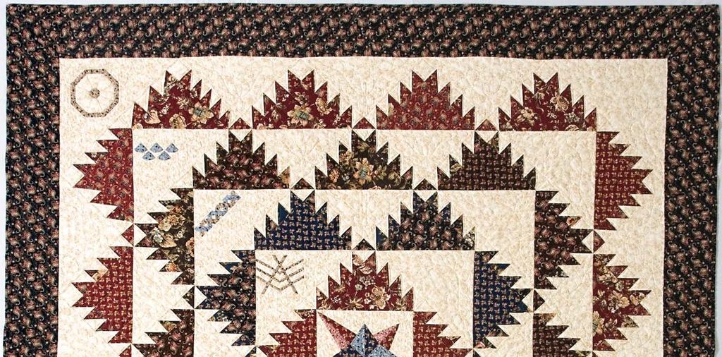
11 Lévis St. Lawrence River Land cover, part of the Chaudière-Appalaches region, circa
12 Lévis St. Lawrence River Land cover, part of the Chaudière-Appalaches region, circa
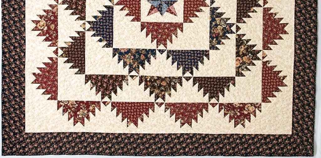
13 Land cover, part of the Chaudière-Appalaches region, region,circa circa2006, 2006,100 1 km mgrid grid 13
14 Land cover by 100 m unit, part of the Chaudière-Appalaches region, circa
15 Comments on the results Preliminary measurements of the area by land cover type for both years and of the change in stock Size of the error term on the change in stock estimates? Part of error term attributable to the differences between the data sets Alternatives: Reduce the number of land cover classes and review the decisions taken to integrate the data Use other data and accept a lower precision 15
16 Conclusion Feasible to create land accounts for Québec using existing data Test of a methodology for creating land accounts based on a variety of data Statistical infrastructure for Québec land accounts Some discrepancies between the land cover classification proposed for Québec and the SEEA s classification Grids system in accordance with the methodology proposed for the SEEA Experimental Ecosystem Accounts Flexibility in calculating results Next steps Land accounts for the whole of Québec and for a more recent reference year (2011) Extension into ecosystem accounts Northern Québec Biodiversity Atlas (Atlas de la biodiversité du Québec nordique, MDDEP) 16
Extent. Level 1 and 2. October 2017
 Extent Level 1 and 2 October 2017 Overview: Extent account 1. Learning objectives 2. Review of Level 0 (5m) 3. Level 1 (Compilers): Concepts (15m) Group exercise and discussion (15m) 4. Level 2 (Data Providers)
System of Environmental-Economic Accounting. Advancing the SEEA Experimental Ecosystem Accounting. Extent Account (Levels 1 and 2)
") Advancing the SEEA Experimental Ecosystem Accounting Extent Account (Levels 1 and 2) Overview: The Extent Account 1. Learning objectives 2. Review of Level 0 (5m) What is it? Why do we need it? What does
Advancing the SEEA Experimental Ecosystem Accounting Extent Account (Levels 1 and 2) Overview: The Extent Account 1. Learning objectives 2. Review of Level 0 (5m) What is it? Why do we need it? What does
Land Accounting. Sub-regional Workshop on Environment Statistics for South and South-West Asian Countries. Michael Bordt ESCAP
 Land Accounting Michael Bordt ESCAP bordt@un.org Sub-regional Workshop on Environment Statistics for South and South-West Asian Countries Feb. 6-8, 2017 Bangkok, Thailand Overview: Land Accounting Learning
Accounting Units for Ecosystem Accounts Paper prepared by Alessandra Alfieri, Daniel Clarke, and Ivo Havinga United Nations Statistics Division
 DEPARTMENT OF ECONOMIC AND SOCIAL AFFAIRS STATISTICS DIVISION UNITED NATIONS Expert Meeting on Ecosystem Accounts London, UK 5-7 December 2011 Accounting Units for Ecosystem Accounts Paper prepared by
SEEA Experimental Ecosystem Accounting
 SEEA Experimental Ecosystem Accounting Sokol Vako United Nations Statistics Division Training for the worldwide implementation of the System of Environmental Economic Accounting 2012 - Central Framework
Land Accounts - The Canadian Experience
 Land Accounts - The Canadian Experience Development of a Geospatial database to measure the effect of human activity on the environment Who is doing Land Accounts Statistics Canada (national) Component
Pilot studies on the provision of harmonized land use/land cover statistics: Synergies between LUCAS and the national systems
 1 Pilot studies on the provision of harmonized land use/land cover statistics: Synergies between LUCAS and the national systems Norway Erik Engelien Division for Natural resources and Environmental Statistics,
Technical Note: Land Accounting
 AUSTRALIAN BUREAU OF STATISTICS Technical Note: Land Accounting Version 1.1 Michael Vardon and Tom Walter 9/19/2013 This note introduces the land accounts from the System of Environmental-Economic Statistics
Global Land Cover Mapping
 Global Land Cover Mapping and its application in SDGs Prof. Chen Jun 1, Dr. He Chaoying 2 1 National Geomatics Center of China (NGCC) 2 Ministry of Natural Resources, P.R.China May 30, 2018, Copenhagen
NATIONAL VEGETATION CLASSIFICATION STANDARD, VERSION 2 WORKING DRAFT
 NATIONAL VEGETATION CLASSIFICATION STANDARD, VERSION 2 WORKING DRAFT Subcommittee Federal Geographic Data Committee SUMMMARY NatureServe version 31 August 2006 INTRODUCTION The United States Federal Geographic
Land Accounts in Canada
 Land Accounts in Canada 22 nd meeting of the London Group September 29 th, 2016 Statistics Norway, Oslo Gabriel Gagnon Statistics Canada Land accounts in Canada OVERVIEW Context Strategic direction Latest
Note on Definition of Socio-Ecological Landscape Unit, SELU Classification and its Policy Application
 Note on Definition of Socio-Ecological Landscape Unit, SELU Classification and its Policy Application Alessandra Alfieri, Daniel Clarke and Ivo Havinga, United Nations Statistics Division and Jean Louis
Capabilities and Limitations of Land Cover and Satellite Data for Biomass Estimation in African Ecosystems Valerio Avitabile
 Capabilities and Limitations of Land Cover and Satellite Data for Biomass Estimation in African Ecosystems Valerio Avitabile Kaniyo Pabidi - Budongo Forest Reserve November 13th, 2008 Outline of the presentation
CORINE LAND COVER CROATIA
 CORINE LAND COVER CROATIA INTRO Primary condition in making decisions directed to land cover and natural resources management is presence of knowledge and high quality information about biosphere and its
Southwest LRT Habitat Analysis. May 2016 Southwest LRT Project Technical Report
 Southwest LRT Habitat Analysis Southwest LRT Project Technical Report This page intentionally blank. Executive Summary This technical report describes the habitat analysis that was performed to support
Data Visualization and Evaluation
 Data Visualization and Evaluation Juan Paulo Ramírez, Ph.D. University of Nebraska 5th Annual Environmental Evaluators Networking Forum June 2010 Purpose and Objectives Purpose Introduce to program evaluators
Measuring ecosystems and biodiversity and related goods and services
 Measuring ecosystems and biodiversity and related goods and services World Bank, WAVES Partnership Meeting Michael Bordt, EASD Statistics Canada March 30, 2011 Outline What exists already in Canada and
NATIONAL MAPPING EFFORTS: THE PHILIPPINES
 NATIONAL MAPPING EFFORTS: THE PHILIPPINES Dr. RIJALDIA N. SANTOS DENR National Mapping and Resource Information Authority (NAMRIA) May 30, 2018 Land Cover/Land Use Changes (LC/LUC) and Its Impacts on Environment
AGOG 485/585 /APLN 533 Spring Lecture 5: MODIS land cover product (MCD12Q1). Additional sources of MODIS data
. Additional sources of MODIS data") AGOG 485/585 /APLN 533 Spring 2019 Lecture 5: MODIS land cover product (MCD12Q1). Additional sources of MODIS data Outline Current status of land cover products Overview of the MCD12Q1 algorithm Mapping
AGOG 485/585 /APLN 533 Spring 2019 Lecture 5: MODIS land cover product (MCD12Q1). Additional sources of MODIS data Outline Current status of land cover products Overview of the MCD12Q1 algorithm Mapping
ISO Land Cover for Agricultural Regions of Canada, Circa 2000 Data Product Specification. Revision: A
 ISO 19131 Land Cover for Agricultural Regions of Canada, Circa 2000 Data Product Specification Revision: A Data specification: Land Cover for Agricultural Regions, circa 2000 Table of Contents 1. OVERVIEW...
Data sources and classification for ecosystem accounting g
 Data sources and classification for ecosystem accounting Ken Bagstad 23 February 2015 Wealth Accounting and the Valuation of Ecosystem Services www.wavespartnership.org Data sources and classification
FDES: Chapter 1. Overview of Environment Statistics Characteristics and Challenges. FDES: Framework for the Development of Environment Statistics
 FDES: Chapter 1 Overview of Environment Statistics Characteristics and Challenges FDES: Framework for the Development of Environment Statistics 6. 2. Environment Environmental Protection, Resources and
Spatial Units, Scaling and Aggregation (Level 1) October 2017
 October 2017") Spatial Units, Scaling and Aggregation (Level 1) October 2017 Overview: Spatial Units 1. Learning objectives 2. Review of Level 0 (5m) 3. Level 1 (Compilers): Presentation & group exercise Spatial units
Spatial Units, Scaling and Aggregation (Level 1) October 2017 Overview: Spatial Units 1. Learning objectives 2. Review of Level 0 (5m) 3. Level 1 (Compilers): Presentation & group exercise Spatial units
LUCAS: current product and its evolutions
 LUCAS: current product and its evolutions Workshop Land Use and Land Cover products: challenges and opportunities Brussels 15 Nov 2017 Eurostat E4: estat-dl-lucas@ec.europa.eu Contents 1) The context 2)
SIF_7.1_v2. Indicator. Measurement. What should the measurement tell us?
 Indicator 7 Area of natural and semi-natural habitat Measurement 7.1 Area of natural and semi-natural habitat What should the measurement tell us? Natural habitats are considered the land and water areas
An Internet-based Agricultural Land Use Trends Visualization System (AgLuT)
") An Internet-based Agricultural Land Use Trends Visualization System (AgLuT) Second half yearly report 01-01-2001-06-30-2001 Prepared for Missouri Department of Natural Resources Missouri Department of
An Internet-based Agricultural Land Use Trends Visualization System (AgLuT) Second half yearly report 01-01-2001-06-30-2001 Prepared for Missouri Department of Natural Resources Missouri Department of
Land Cover and Land use in Environment Statistics
 UNITED NATIONS STATISTICS DIVISION (UNSD) Workshop on Environment Statistics in support of the implementation of the Framework for the Development of Environment Statistics (FDES 2013) Balaclava, Mauritius
Geography Teach Yourself Series Topic 4: Global Distribution of Land Cover
 Geography Teach Yourself Series Topic 4: Global Distribution of Land Cover A: Level 14, 474 Flinders Street Melbourne VIC 3000 T: 1300 134 518 W: tssm.com.au E: info@tssm.com.au TSSM 2016 Page 1 of 7 Contents
Criteria for delineating a new boundary for the Fisher Bay Park Reserve, Manitoba
 1 Criteria for delineating a new boundary for the Fisher Bay Park Reserve, Manitoba R. A. Lastra Department of Botany, University of Manitoba, Winnipeg, MB, Canada, R3T 2N2 1. INTRODUCTION Historic park
Application and impacts of the GlobeLand30 land cover dataset on the Beijing Climate Center Climate Model
 IOP Conference Series: Earth and Environmental Science PAPER OPEN ACCESS Application and impacts of the GlobeLand30 land cover dataset on the Beijing Climate Center Climate Model To cite this article:
Copernicus for Statistics
 Copernicus for Statistics Stephan Arnold Areal statistics, Federal Statistical Office Thomas Wiatr Remote sensing, Federal Agency for Cartography and Geodesy Content Requirements and Setting Eurostat s
BIODIVERSITY CONSERVATION HABITAT ANALYSIS
 BIODIVERSITY CONSERVATION HABITAT ANALYSIS A GIS Comparison of Greater Vancouver Regional Habitat Mapping with Township of Langley Local Habitat Mapping Preface This report was made possible through the
Calculating Drive-time Buffers and Territories with Sparse Road Network
 Calculating Drive-time Buffers and Territories with Sparse Road Network Ran Tao 1, Jean-Claude Thill 1, James Walsh 1 Daniel Strandow 2, Michael Findley 3 1 University of North Carolina at Charlotte 2
Appendix E: Cowardin Classification Coding System
 Appendix E: Cowardin Classification Coding System The following summarizes the Cowardin classification coding system and the letters and numbers used to define the USFWS NWI wetland types and subtypes:
Global Patterns Gaston, K.J Nature 405. Benefit Diversity. Threats to Biodiversity
 Biodiversity Definitions the variability among living organisms from all sources, including, 'inter alia', terrestrial, marine, and other aquatic ecosystems, and the ecological complexes of which they
CHAPTER 1 THE UNITED STATES 2001 NATIONAL LAND COVER DATABASE
 CHAPTER 1 THE UNITED STATES 2001 NATIONAL LAND COVER DATABASE Collin Homer*, Jon Dewitz, Joyce Fry, and Nazmul Hossain *U.S. Geological Survey (USGS) Center for Earth Resources Observation and Science
Through their research, geographers gather a great deal of data about Canada.
 Ecozones What is an Ecozone? Through their research, geographers gather a great deal of data about Canada. To make sense of this information, they often organize and group areas with similar features.
Directorate E: Sectoral and regional statistics Unit E-4: Regional statistics and geographical information LUCAS 2018.
 EUROPEAN COMMISSION EUROSTAT Directorate E: Sectoral and regional statistics Unit E-4: Regional statistics and geographical information Doc. WG/LCU 52 LUCAS 2018 Eurostat Unit E4 Working Group for Land
GIS at the Purdue Center for Regional Development: Some Examples
 GIS at the Purdue Center for Regional Development: Some Examples Indraneel Kumar SHaPE Brownbag Seminar February 1st, 2008 Regional Development for Local Success GIS Tools ESRI ArcGIS suite (ArcInfo-Workstation)
Exploring GIS Potential for Northwestern Ontario Land Information Ontario
 Exploring GIS Potential for Northwestern Ontario Land Information Ontario May 13, 2015 The LIO Vision LIO Vision: That all geographic information about Ontario is fully integrated and accessible LIO Goal:
Wisconsin River Floodplain Project: Overview and Plot Metadata
 Wisconsin River Floodplain Project: Overview and Plot Metadata CLASS I. DATA SET DESCRIPTORS Data set identity: Plot-level variable information for Wisconsin River Floodplain Project. Relevant for following
COMBINING ENUMERATION AREA MAPS AND SATELITE IMAGES (LAND COVER) FOR THE DEVELOPMENT OF AREA FRAME (MULTIPLE FRAMES) IN AN AFRICAN COUNTRY:
 FOR THE DEVELOPMENT OF AREA FRAME (MULTIPLE FRAMES) IN AN AFRICAN COUNTRY:") COMBINING ENUMERATION AREA MAPS AND SATELITE IMAGES (LAND COVER) FOR THE DEVELOPMENT OF AREA FRAME (MULTIPLE FRAMES) IN AN AFRICAN COUNTRY: PRELIMINARY LESSONS FROM THE EXPERIENCE OF ETHIOPIA BY ABERASH
COMBINING ENUMERATION AREA MAPS AND SATELITE IMAGES (LAND COVER) FOR THE DEVELOPMENT OF AREA FRAME (MULTIPLE FRAMES) IN AN AFRICAN COUNTRY: PRELIMINARY LESSONS FROM THE EXPERIENCE OF ETHIOPIA BY ABERASH
Spatial Disaggregation of Land Cover and Cropping Information: Current Results and Further steps
 CAPRI CAPRI Spatial Disaggregation of Land Cover and Cropping Information: Current Results and Further steps Renate Koeble, Adrian Leip (Joint Research Centre) Markus Kempen (Universitaet Bonn) JRC-AL
UNSD SEEA-EEA revision 2020
 UNSD SEEA-EEA revision 2020 Area 1: Spatial units; introduction Sjoerd Schenau, Patrick Bogaart, Edwin Horlings London group meeting, October 2018 Overview Spatial units in SEEA EEA Main revision issues
Implementation of the NCEP operational GLDAS for the CFS land initialization
 Implementation of the NCEP operational GLDAS for the CFS land initialization Jesse Meng, Mickael Ek, Rongqian Yang NOAA/NCEP/EMC July 2012 1 Improving the Global Land Surface Climatology via improved Global
Spanish national plan for land observation: new collaborative production system in Europe
 ADVANCE UNEDITED VERSION UNITED NATIONS E/CONF.103/5/Add.1 Economic and Social Affairs 9 July 2013 Tenth United Nations Regional Cartographic Conference for the Americas New York, 19-23, August 2013 Item
Global Biogeography. Natural Vegetation. Structure and Life-Forms of Plants. Terrestrial Ecosystems-The Biomes
 Global Biogeography Natural Vegetation Structure and Life-Forms of Plants Terrestrial Ecosystems-The Biomes Natural Vegetation natural vegetation is the plant cover that develops with little or no human
Dataset Information: Land Cover. Title. Abstract. Supplemental. International Standards. Creation Date Last Update Data Type.
 Dataset Information: Land Cover Title Abstract Supplemental International Standards Land Cover The FAOSTAT Agri Environmental Indicators Land Cover domain contains data on area by land cover class, by
Key Concepts. (Level 0) October 2017
 October 2017") Key Concepts (Level 0) October 2017 Overview SEEA-EEA Training (Level 0) > Overview of training modules > Basic concepts: Ecosystems as Assets Ecosystem Services Cascade Accounting Principles Ecosystem
Key Concepts (Level 0) October 2017 Overview SEEA-EEA Training (Level 0) > Overview of training modules > Basic concepts: Ecosystems as Assets Ecosystem Services Cascade Accounting Principles Ecosystem
W I N D R E S O U R C E A S S E S S M E N T
 W I N D R E S O U R C E A S S E S S M E N T Annual Energy Production Project: Hundhammer_WS_Express Layout: Layout1 Customer: WindSim 2014-01-29 WindSim AS Fjordgaten 15, N- 3125 Tønsberg, Norway phone.:
Discussion paper on spatial units
 Discussion paper on spatial units for the Forum of Experts in SEEA Experimental Ecosystem Accounting 2018 Version: 8 June 2018 Prepared by: SEEA EEA Revision Working Group 1 on spatial units (led by Sjoerd
Ecosystems Chapter 4. What is an Ecosystem? Section 4-1
 Ecosystems Chapter 4 What is an Ecosystem? Section 4-1 Ecosystems Key Idea: An ecosystem includes a community of organisms and their physical environment. A community is a group of various species that
Earth s Major Terrerstrial Biomes. *Wetlands (found all over Earth)
") Biomes Biome: the major types of terrestrial ecosystems determined primarily by climate 2 main factors: Depends on ; proximity to ocean; and air and ocean circulation patterns Similar traits of plants
Biomes Biome: the major types of terrestrial ecosystems determined primarily by climate 2 main factors: Depends on ; proximity to ocean; and air and ocean circulation patterns Similar traits of plants
Classification of Erosion Susceptibility
 GEO327G: GIS & GPS Applications in Earth Sciences Classification of Erosion Susceptibility Denali National Park, Alaska Zehao Xue 12 3 2015 2 TABLE OF CONTENTS 1 Abstract... 3 2 Introduction... 3 2.1 Universal
Supplementary material: Methodological annex
 1 Supplementary material: Methodological annex Correcting the spatial representation bias: the grid sample approach Our land-use time series used non-ideal data sources, which differed in spatial and thematic
Data Fusion and Multi-Resolution Data
 Data Fusion and Multi-Resolution Data Nature.com www.museevirtuel-virtualmuseum.ca www.srs.fs.usda.gov Meredith Gartner 3/7/14 Data fusion and multi-resolution data Dark and Bram MAUP and raster data Hilker
Patrick Leinenkugel. German Aerospace Center (DLR) Vortrag > Autor > Dokumentname > Datum
 Vortrag > Autor > Dokumentname > Datum") Characterisation of land surface phenology and land cover for the Mekong Basin on the basis of multitemporal and multispectral satellite data from the MODIS Sensor Patrick Leinenkugel German Aerospace
Characterisation of land surface phenology and land cover for the Mekong Basin on the basis of multitemporal and multispectral satellite data from the MODIS Sensor Patrick Leinenkugel German Aerospace
Ecological Land Cover Classification For a Natural Resources Inventory in the Kansas City Region, USA
 Ecological Land Cover Classification For a Natural Resources Inventory in the Kansas City Region, USA by Applied Ecological Services, Inc. In cooperation with the Mid-America Regional Council 600 Broadway,
Data Sources and Methods for the Protected Areas Indicators. July 2012
 Data Sources and Methods for the Protected Areas Indicators July 2012 ISBN : En4-144/11-2012E-PDF Cat. No.: 978-1-100-20994-4 Information contained in this publication may be reproduced, in part or in
Canadian Geography Final Exam Review (September to Mid-term Exam)
") Canadian Geography 1202 - Final Exam Review (September to Mid-term Exam) Glossary Terms: Some of the following terms may be covered in the questions that follow. System Natural System Ecosystem Human System
Canadian Geography 1202 - Final Exam Review (September to Mid-term Exam) Glossary Terms: Some of the following terms may be covered in the questions that follow. System Natural System Ecosystem Human System
Geospatial technology for land cover analysis
 Home Articles Application Environment & Climate Conservation & monitoring Published in : Middle East & Africa Geospatial Digest November 2013 Lemenkova Polina Charles University in Prague, Faculty of Science,
Remote Sensing of SWE in Canada
 Remote Sensing of SWE in Canada Anne Walker Climate Research Division, Environment Canada Polar Snowfall Hydrology Mission Workshop, June 26-28, 2007 Satellite Remote Sensing Snow Cover Optical -- Snow
Global Ecosystem Mapping For UN SEEA Ecosystem Accounting
 Global Ecosystem Mapping For UN SEEA Ecosystem Accounting Roger Sayre (U. S. Geological Survey); Dawn Wright, Sean Breyer, Charlie Frye, and others (Esri) UN SEEA Experts Forum on Ocean Ecosystem Accounting
ISO Land Use 1990, 2000, 2010 Data Product Specifications. Revision: A
 ISO 19131 Land Use 1990, 2000, 2010 Data Product Specifications Revision: A Contents 1 OVERVIEW... 3 1.1 Informal description... 3 1.2 Data product specifications Metadata... 3 1.3 Terms and Definitions...
Watershed Classification with GIS as an Instrument of Conflict Management in Tropical Highlands of the Lower Mekong Basin
 Page 1 of 8 Watershed Classification with GIS as an Instrument of Conflict Management in Tropical Highlands of the Lower Mekong Basin Project Abstract The University of Giessen is actually planning a research
Introduction. Ecology is the scientific study of the interactions between organisms and their environment.
 Introduction Ecology is the scientific study of the interactions between organisms and their environment. 1. The interactions between organisms and their environments determine the distribution and abundance
Practical Uses of LiDAR in NL A Consultants Perspective
 Practical Uses of LiDAR in NL A Consultants Perspective Adam Anderson, R.P.F. President & CEO Presented by: Peter Davison, R.P.F. Photo Interpretation Specialist Introduction Resource Innovations Inc.
Yaneev Golombek, GISP. Merrick/McLaughlin. ESRI International User. July 9, Engineering Architecture Design-Build Surveying GeoSpatial Solutions
 Yaneev Golombek, GISP GIS July Presentation 9, 2013 for Merrick/McLaughlin Conference Water ESRI International User July 9, 2013 Engineering Architecture Design-Build Surveying GeoSpatial Solutions Purpose
7.1 INTRODUCTION 7.2 OBJECTIVE
 7 LAND USE AND LAND COVER 7.1 INTRODUCTION The knowledge of land use and land cover is important for many planning and management activities as it is considered as an essential element for modeling and
the Clinch/Hidden Valley study site were used in this mountainous classification.
 the Clinch/Hidden Valley study site were used in this mountainous classification. Deciduous forest was present on over half of the image (Table 97). Coniferous forest and herbaceous were the only other
Impact Policies Enabling Value Enhancement of Geospatial Information in Canadian Economy and Society
 1 Impact Policies Enabling Value Enhancement of Geospatial Information in Canadian Economy and Society May 26, 2015 Prashant Shukle, Director General Canada Centre for Mapping and Earth Observation Increased
Classification of ecosystem types: Experiences and perspectives from Statistics Canada
 Classification of ecosystem types: Experiences and perspectives from Statistics Canada Jennie Wang, François Soulard, Mark Henry, Marcelle Grenier Environmental Accounts and Statistics Program Statistics
KNOWLEDGE-BASED CLASSIFICATION OF LAND COVER FOR THE QUALITY ASSESSEMENT OF GIS DATABASE. Israel -
 KNOWLEDGE-BASED CLASSIFICATION OF LAND COVER FOR THE QUALITY ASSESSEMENT OF GIS DATABASE Ammatzia Peled a,*, Michael Gilichinsky b a University of Haifa, Department of Geography and Environmental Studies,
Accounting for Ecosystem and Biodiversity Related Themes in Uganda
 Introduction Accounting for Ecosystem and Biodiversity Related Themes in Uganda Calls for more evidence-based approaches to policy have increased the need for integrated environmental-economic information
ARCH PROJET Activity 1 -Synthesis-
 ARCH PROJET Activity 1 -Synthesis- CONTENT 1 ARCH project context... 3 1.1. General context... 3 1.2. The ARCH Project... 3 1.3. The Project ARCH partners... 3 1.4. The ARCH project content... 4 2 Activity
Changes in Seasonal Albedo with Land Cover Class
 Name: Date: Changes in Seasonal Albedo with Land Cover Class Guiding question: How does albedo change over the seasons in different land cover classes? Introduction. Now that you have completed the Introduction
ANCILLARY DATA VARIABLES
 ANCILLARY DATA VARIABLES PROCESSING INFORMATION AND MODELING USES Version 1.0 1 BACKGROUND The ancillary data component of the project included creation of a core dataset of 58 variables, of which 24 variables
KENYA NATIONAL BUREAU OF STATISTICS Workshop on
 KENYA NATIONAL BUREAU OF STATISTICS Workshop on Capacity Building in Environment Statistics: the Framework for the Development of Environment Statistics (FDES 2013) Coordination with Sector Ministries
Wetland Mapping. Wetland Mapping in the United States. State Wetland Losses 53% in Lower US. Matthew J. Gray University of Tennessee
 Wetland Mapping Caribbean Matthew J. Gray University of Tennessee Wetland Mapping in the United States Shaw and Fredine (1956) National Wetlands Inventory U.S. Fish and Wildlife Service is the principle
Name Hour. Section 4-1 The Role of Climate (pages 87-89) What Is Climate? (page 87) 1. How is weather different from climate?
 What Is Climate? (page 87) 1. How is weather different from climate?") Name Hour Section 4-1 The Role of Climate (pages 87-89) What Is Climate? (page 87) 1. How is weather different from climate? 2. What factors cause climate? The Greenhouse Effect (page 87) 3. Circle the
Name Hour Section 4-1 The Role of Climate (pages 87-89) What Is Climate? (page 87) 1. How is weather different from climate? 2. What factors cause climate? The Greenhouse Effect (page 87) 3. Circle the
Using VIIRS Land Surface Temperature to Evaluate NCEP North American Mesoscale Model (NAM) Forecast
 Forecast") Using VIIRS Land Surface Temperature to Evaluate NCEP North American Mesoscale Model (NAM) Forecast Zhuo Wang (University of Maryland) Yunyue Yu (NOAA/NESDIS/STAR) Peng Yu (University of Maryland) Yuling
Using VIIRS Land Surface Temperature to Evaluate NCEP North American Mesoscale Model (NAM) Forecast Zhuo Wang (University of Maryland) Yunyue Yu (NOAA/NESDIS/STAR) Peng Yu (University of Maryland) Yuling
Biology and the hierarchies of life. finer scale. coarser scale. individual. populations. metapopulation. community. ecosystem. biome.
 Biology and the hierarchies of life finer scale individual populations metapopulation community ecosystem biome coarser scale biosphere 1 Communities: all species that live together in one place Eucalypt
What is a Biome? An Overview of Biomes. The Holdridge Life Zones. Tundra 9/14/2010. In the following slides, you ll
 An Overview of Biomes What is a Biome? A biome describes a habitat type Biomes are primarily described by average temperature, annual precipitation, length of growing season, and dominant vegetation type
Chapter 52 An Introduction to Ecology and the Biosphere
 Chapter 52 An Introduction to Ecology and the Biosphere Ecology The study of the interactions between organisms and their environment. Ecology Integrates all areas of biological research and informs environmental
Phase 6 Land Use Database version 2
 Phase 6 Land Use Database version 2 Peter Claggett, Fred Irani, Quentin Stubbs, and Renee Thompson. October 5, 2015 Modeling Workgroup Quarterly Annapolis, Maryland U.S. Department of the Interior U.S.
Biomes and Biodiversity
 Biomes and Biodiversity Agenda 2/4/13 Biomes review terrestrial and aquatic Biodiversity Climate Change Introduction Weather Terrestrial Biomes Review Tundra Boreal Forest (Taiga) Temperate Forest Temperate
APPENDIX PHASE 1 GREEN INFRASTRUCTURE FRAMEWORK
 APPENDIX PHASE 1 GREEN INFRASTRUCTURE FRAMEWORK KANSAS MISSOURI CONTENTS A DATA WISHLIST 4 B PRECEDENTS 7 C WORKSHOP MATERIALS 13 D ANALYSIS PROCESS 124 E ATLAS & PLAYBOOK DETAILS 156 F POLICY ANALYSIS
The Redwood National and State Parks Vegetation Classification and Mapping Project Map Data Sets Completed and Delivered! 1
 The Redwood National and State Parks Vegetation Classification and Mapping Project Map Data Sets Completed and Delivered! 1 By Ken Stumpf and Leonel Arguello The Redwood National and State Parks Vegetation
INTERNATIONAL JOURNAL OF GEOMATICS AND GEOSCIENCES Volume 4, No 2, 2013
 INTERNATIONAL JOURNAL OF GEOMATICS AND GEOSCIENCES Volume 4, No 2, 2013 Copyright 2010 All rights reserved Integrated Publishing services Research article ISSN 0976 4380 Evaluation of landuse / landcover
EBA Engineering Consultants Ltd. Creating and Delivering Better Solutions
 EBA Engineering Consultants Ltd. Creating and Delivering Better Solutions ENHANCING THE CAPABILITY OF ECOSYSTEM MAPPING TO SUPPORT ADAPTIVE FOREST MANAGEMENT Prepared by: EBA ENGINEERING CONSULTANTS LTD.
Name Date Class. well as the inland, found near the Tropics. 4. In the, or the regions near the Equator, you may find a lush
 WATER, CLIMATE, AND VEGETATION Vocabulary Activity DIRECTIONS: Fill in the Blanks Select a term from below to complete each of the following sentences. CHAPTER 1. The constant movement of water, a process
Role of GIS and Remote Sensing to Environment Statistics
 United Nations Economic Commission for Africa Role of GIS and Remote Sensing to Environment Dozie Ezigbalike Data Management Coordinator A Definition Environment statistics are statistics that describe
Worldwide inventory of landscapes through segmentation of global land cover dataset
 Worldwide inventory of landscapes through segmentation of global land cover dataset J. Nowosad* 1 and T. F. Stepinski 1 1 University of Cincinnati, Cincinnati, OH, 45221, USA * Email: nowosad.jakub@gmail.com
EAGLE Data Model and Outcomes of HELM (Harmonised European Land Monitoring)
") EAGLE Data Model and Outcomes of HELM (Harmonised European Land Monitoring) Contribution towards better land information harmonisation and INSPIRE compliance EAGLE working group Stephan Arnold, Barbara
EAGLE Data Model and Outcomes of HELM (Harmonised European Land Monitoring) Contribution towards better land information harmonisation and INSPIRE compliance EAGLE working group Stephan Arnold, Barbara
Standardization of the land cover classes using FAO Land Cover Classification System (LCCS)
") Sofia, 17-18 September 2008, LPIS Workshop LPIS applications and quality 1 Standardization of the land cover classes using FAO Land Cover Classification System (LCCS) Pavel MILENOV Agriculture Unit, JRC
Sofia, 17-18 September 2008, LPIS Workshop LPIS applications and quality 1 Standardization of the land cover classes using FAO Land Cover Classification System (LCCS) Pavel MILENOV Agriculture Unit, JRC
Delta Flood Protection Strategy Update. May 16, 2016
 Delta Flood Protection Strategy Update May 16, 2016 Presentation Overview 1. Background 2. Understanding the Dike Reaches/Issues 3. Future Dike Improvements 4. Next Steps Boundary Bay Village March 10,
Most people used to live like this
 Urbanization Most people used to live like this Increasingly people live like this. For the first time in history, there are now more urban residents than rural residents. Land Cover & Land Use Land cover
Chapter 7 Part III: Biomes
 Chapter 7 Part III: Biomes Biomes Biome: the major types of terrestrial ecosystems determined primarily by climate 2 main factors: Temperature and precipitation Depends on latitude or altitude; proximity
First steps toward a comparison of modelled thermal comfort during a heatwave in Melbourne, Australia
 First steps toward a comparison of modelled thermal comfort during a heatwave in Melbourne, Australia Stephanie Jacobs PhD supervisors: Ailie Gallant and Nigel Tapper Outline of talk Motivation for research
Land accounting perspective on water resources management
 European Water 60: 161-166, 2017. 2017 E.W. Publications Land accounting perspective on water resources management G.T. Paschos, G.E. Bariamis * and E.A. Baltas Department of Water Resources and Environmental