Too much trust in the past
|
|
|
- Godwin Spencer
- 5 years ago
- Views:
Transcription


1 Agnieszka Szajnert, Jan Pryzowicz Too much trust in the past The problems of hydrographical data credibility

2 Hydrographical spatial data sets in Poland Why? Where? How many? President of National Water Management Authority is obliged by Polish Water Law to gather hydrographical information within Water Cadaster. INSPIRE Hydrography 1: Map of Hydrographical Division of Poland 1: Water Cadaster Map of Hydrographical Division of Poland 1: INSPIRE Hydrography 1:50 000

3 Map of Hydrographical Division of Poland 1: (MPHP50) ORIGINS Diapositives of water network maps Topographical maps of Poland 1: Diapositives of terrain sculpture maps Map of Hydrographical Division of Poland 1: First version: 2004 Latest version: 2010 Format: Geodatabase & Shapefile Total length of river network: km Number of elementary water catchment areas
 Hydro nodes (point) Wide rives (polygon) Undistinguished rivers (polyline) Lakes (polygon) Undistinguished lakes (polygon) Watersheds (polyline) Watershed nodes (point) Map sections")
4 Map of Hydrographical Division of Poland 1: OVERVIEW DATA RANGE Elementary water catchment areas (polygon) Water catchment areas (polygon) from level 1 to 9 Rivers (polyline) Rivers sections (polyline) Hydro nodes (point) Wide rives (polygon) Undistinguished rivers (polyline) Lakes (polygon) Undistinguished lakes (polygon) Watersheds (polyline) Watershed nodes (point) Map sections (polygon)
5 Map of Hydrographical Division of Poland 1: (MPHP10) ORIGINS Orthophotomaps Database of topographic objects Topographic maps of Poland 1: State Register of Geographical names First version: 2013 Latest version: 2016 Format: Geodatabase & Shapefile Digital Elevation Model MPHP10 Map of Hydrographical Division of Poland 1: Total length of river network: km Number of elementary water catchment areas
 Hydro nodes (point) Wide rives (polygon) Undistinguished rivers (polyline) Undistinguished rivers - sections (polyline) Lakes and reservoirs (polygon) Undistinguished lakes (polygon)")
6 Map of Hydrographical Division of Poland 1: OVERVIEW DATA RANGE Elementary water catchment areas (polygon) Water catchment areas (polygon) from level 1 to 14 Rivers (polyline) Rivers sections (polyline) Hydro nodes (point) Wide rives (polygon) Undistinguished rivers (polyline) Undistinguished rivers - sections (polyline) Lakes and reservoirs (polygon) Undistinguished lakes (polygon) Watersheds (polyline) Watershed nodes (point) Map sections (polygon)
7 September October 2015 Map of Hydrographical Division of Poland 1: First time as a reference data set Update of surface water bodies and combined water bodies list for next edition of river basin management plans for the period along with verification of types of water bodies Update of types and boundaries of surface water bodies River Lake Transitional Coastal OUTCOME New list of water bodies, based on new and previously inaccessible data, for the second update of river basin management plans in 2021
 including the rush communities border by land Method b) excluding the rush communities border by water\" Both method a) and b) within the")

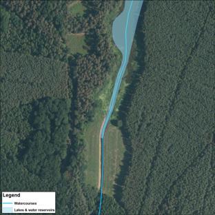
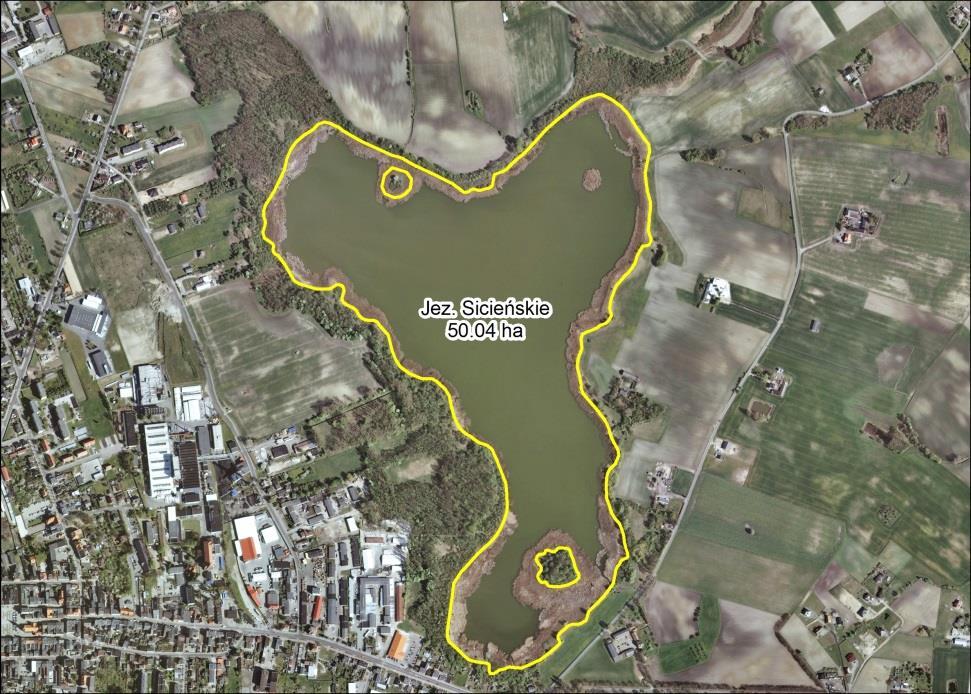
8 Ad. 1a) Identified errors and inconsistencies 1. Heterogeneous methodology for geometry determination of lakes and water reservoirs in MPHP10. Method a) including the rush communities border by land Method b) excluding the rush communities border by water" Both method a) and b) within the same body of water 2. Dubious designation of shoreline - addition of river and canal sections as well as islands into the lakes basins. 3. Unreasonable cases of lake basin division into smaller basins or lack of such division in cases hydrologically justified. Grabowskie Lake Ad. 1b) Mąkolno Lake

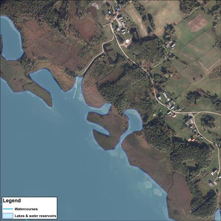
9 Identified errors and inconsistencies Ad. 1c) Wigry Lake Ad. 2 Jeżewo Reservoir
10 1st stage (ends by the 16th of October 2017) A way to fix it New project lunched in September 2017 ANALYSIS AND UPDATE OF MANAGEMENT UNITS WITH THE CONSIDERATION OF MPHP10 (Map of Hydrographical Division of Poland 1:10 000) MPHP10 correction based on issues related to the lake layer and other layers that may have a significant impact on the identification/designation of water bodies for the 3rd cycle of WFD implementation. 2nd stage (ends by the 31st of November 2017) Adjustment (where appropriate) of the list of surface water bodies along with the attribution of surface water types and re-designation of the boundaries of: regional water management authorities, river basin districts and water regions.

11 What s the plan? COPERNICUS FOR THE RESCUE Main data sources: Numerical data from Central Unit of Geodetic and Cartographic Documentation Data from the European Space Agency Copernicus program Identification of Plant communities within bodies of water is based on NDVI index developed on the basis of multi-channel imageries made by the Copernicus Sentinel-2A remote sensing satellite. The NDVI (Normalized Difference Vegetation Index) index is the most known and used vegetation mapping index. Negative values of NDVI (values close to -1) correspond to water. Values close to zero (-0.1 to 0.1) generally correspond to sterile rock, sand or snow. Positive low values are shrubs and pastures (values from 0.2 to 0.4) and high values (close to 1) correspond to areas covered by lush vegetation in good condition.

12 Preliminary results NEW HOPE
Updating of the Finnish Drainage Basin System and Register Case VALUE
 Updating of the Finnish Drainage Basin System and Register Case VALUE Juha Oksanen 1, Matti Joukola 2, Riitta Teiniranta 2, Jaakko Suikkanen 2, Tapani Sarjakoski 1 1 Department of Geoinformatics and Cartography,
GIS in Water Resources Midterm Exam Fall 2012 There are five questions on this exam. Please do all five.
 Page 1 of 6 Name: Key GIS in Water Resources Midterm Exam Fall 2012 There are five questions on this exam. Please do all five. Question 1 (a) You have worked with the location of Utah State University
European River Catchment Updates: Iceland, Malta and Romania
 Final Draft Working Document European River Catchment Updates: Iceland, Malta and Romania Prepared by: Alejandro IGLESIAS-CAMPOS ETC-LUSI / Junta de Andalucía 11.01.2008 Version 2 Project manager: Ana
GIS Solutions in Natural Resource Management: Balancing the Technical- Political Equation
 GIS Solutions in Natural Resource Management: Balancing the Technical- Political Equation Stan Morain, Editor SUB Gdttlngen 7 208 520 309 98 A14447 0NW0RD PRESS V? % \
Outcrop suitability analysis of blueschists within the Dry Lakes region of the Condrey Mountain Window, North-central Klamaths, Northern California
 Outcrop suitability analysis of blueschists within the Dry Lakes region of the Condrey Mountain Window, North-central Klamaths, Northern California (1) Introduction: This project proposes to assess the
UNITED NATIONS E/CONF.96/CRP. 5
 UNITED NATIONS E/CONF.96/CRP. 5 ECONOMIC AND SOCIAL COUNCIL Eighth United Nations Regional Cartographic Conference for the Americas New York, 27 June -1 July 2005 Item 5 of the provisional agenda* COUNTRY
GRAPEVINE LAKE MODELING & WATERSHED CHARACTERISTICS
 GRAPEVINE LAKE MODELING & WATERSHED CHARACTERISTICS Photo Credit: Lake Grapevine Boat Ramps Nash Mock GIS in Water Resources Fall 2016 Table of Contents Figures and Tables... 2 Introduction... 3 Objectives...
A GIS View of Hydrology
 Quantitative Elements of Hydrology A GIS View of Hydrology Contact information: Jack Hermance Environmental Geophysics/Hydrology Department of Geological Sciences Brown University, Providence, RI 02912-1846
The National Hydrography Dataset in the Pacific Region. U.S. Department of the Interior U.S. Geological Survey
 The National Hydrography Dataset in the Pacific Region U.S. Department of the Interior U.S. Geological Survey The National Map The National Map is built on partnerships and standards The National Map consists
Analyzing spatial and temporal variation of water balance components in La Vi catchment, Binh Dinh province, Vietnam
 Analyzing spatial and temporal variation of water balance components in La Vi catchment, Binh Dinh province, Vietnam Nguyen Duy Liem, Vo Ngoc Quynh Tram, Nguyen Le Tan Dat, Nguyen Kim Loi Nong Lam University-
software, just as word processors or databases are. GIS was originally developed and cartographic capabilities have been augmented by analysis tools.
 1. INTRODUCTION 1.1Background A GIS is a Geographic Information System, a software package for creating, viewing, and analyzing geographic information or spatial data. GIS is a class of software, just
Improvement of the National Hydrography Dataset for Parts of the Lower Colorado Region and Additional Areas of Importance to the DLCC
 Improvement of the National Hydrography Dataset for Parts of the Lower Colorado Region and Additional Areas of Importance to the DLCC Carlos Reyes-Andrade California State University, Northridge September
International Journal of Advance Engineering and Research Development
 Scientific Journal of Impact Factor (SJIF): 4.72 International Journal of Advance Engineering and Research Development Volume 4, Issue 5, May -2017 Watershed Delineation of Purna River using Geographical
Application of Geographical Information System (GIS) tools in watershed analysis
 tools in watershed analysis") Application of Geographical Information System (GIS) tools in watershed analysis Paritosh Gupta 1, Damanjit S Minhas 2, Rajendra M Tamhane 1, A K Mookerjee 2 1.ESRI India New Delhi 2. LEA Associates South
Application of Geographical Information System (GIS) tools in watershed analysis Paritosh Gupta 1, Damanjit S Minhas 2, Rajendra M Tamhane 1, A K Mookerjee 2 1.ESRI India New Delhi 2. LEA Associates South
Pierce Cedar Creek Institute GIS Development Final Report. Grand Valley State University
 Pierce Cedar Creek Institute GIS Development Final Report Grand Valley State University Major Goals of Project The two primary goals of the project were to provide Matt VanPortfliet, GVSU student, the
CHAPTER VII FULLY DISTRIBUTED RAINFALL-RUNOFF MODEL USING GIS
 80 CHAPTER VII FULLY DISTRIBUTED RAINFALL-RUNOFF MODEL USING GIS 7.1GENERAL This chapter is discussed in six parts. Introduction to Runoff estimation using fully Distributed model is discussed in first
USGS Hydrography Overview. May 9, 2018
 + 1 USGS Hydrography Overview May 9, 2018 + 2 The National Geospatial Program Provides the geospatial baseline of the Nation s topography, natural landscape and built environment through The National Map,
Flood Hazard Mapping for Canada based on Spatial Data Integration and Modeling
 Flood Hazard Mapping for Canada based on Spatial Data Integration and Modeling Qiaoping Zhang 1, Michael Wollersheim 1, Natalie Findlay 1, Stephen Griffiths 1 1 Intermap Technologies Corp., Calgary, AB,
Satellite data for hydrological forecasting
 Satellite data for hydrological forecasting Current use at ECMWF and perspective Shopping list! Our current tools does not allow direct use, but could be modified Christel Prudhomme Christel.prudhomme@ecmwf.int
ABSTRACT The first chapter Chapter two Chapter three Chapter four
 ABSTRACT The researches regarding this doctoral dissertation have been focused on the use of modern techniques and technologies of topography for the inventory and record keeping of land reclamation. The
Effect of land use/land cover changes on runoff in a river basin: a case study
 Water Resources Management VI 139 Effect of land use/land cover changes on runoff in a river basin: a case study J. Letha, B. Thulasidharan Nair & B. Amruth Chand College of Engineering, Trivandrum, Kerala,
Simplified GIS Requirements: New Data Models and Standards for Future WWDC Projects November 15 th, 2017 Technical Training
 Simplified GIS Requirements: New Data Models and Standards for Future WWDC Projects November 15 th, 2017 Technical Training Agenda Project Introduction Data Model and Metadata Framework Plan and Technical
Storm Surge Analysis Update Meeting Cross City, Florida June 17, 2014
 Big Bend Coastal Storm Surge Study Storm Surge Analysis Update Meeting Cross City, Florida June 17, 2014 Introductions Risk MAP Project Team FEMA Region IV Florida Division of Emergency Management (FDEM)
Introduction to Geographic Information Systems (GIS): Environmental Science Focus
: Environmental Science Focus") Introduction to Geographic Information Systems (GIS): Environmental Science Focus September 9, 2013 We will begin at 9:10 AM. Login info: Username:!cnrguest Password: gocal_bears Instructor: Domain: CAMPUS
Introduction to Geographic Information Systems (GIS): Environmental Science Focus September 9, 2013 We will begin at 9:10 AM. Login info: Username:!cnrguest Password: gocal_bears Instructor: Domain: CAMPUS
The production and use of a hydrographic flow-direction network of surface waters. Rickard HALLENGREN, Håkan OLSSON and Erik SISELL, Sweden
 The production and use of a hydrographic flow-direction network of surface waters Rickard HALLENGREN, Håkan OLSSON and Erik SISELL, Sweden Key words: hydrographic, flow-direction network, surface waters
INTRODUCTION TO HEC-HMS
 INTRODUCTION TO HEC-HMS Hydrologic Engineering Center- Hydrologic Modeling System US Army Corps of Engineers Hydrologic Engineering Center HEC-HMS Uses Schematics Enter properties: watershed, rivers (reaches),
State of Israel Ministry of Housing and Construction Survey of Israel. The Hydrological project case
 State of Israel Ministry of Housing and Construction Survey of Israel The Hydrological project case Survey of Israel Content Introduction To the Survey of Israel The operation assumptions The main responsibilities
Applying Hazard Maps to Urban Planning
 Applying Hazard Maps to Urban Planning September 10th, 2014 SAKAI Yuko Disaster Management Expert JICA Study Team for the Metro Cebu Roadmap Study on the Sustainable Urban Development 1 Contents 1. Outline
USING GIS CARTOGRAPHIC MODELING TO ANALYSIS SPATIAL DISTRIBUTION OF LANDSLIDE SENSITIVE AREAS IN YANGMINGSHAN NATIONAL PARK, TAIWAN
 CO-145 USING GIS CARTOGRAPHIC MODELING TO ANALYSIS SPATIAL DISTRIBUTION OF LANDSLIDE SENSITIVE AREAS IN YANGMINGSHAN NATIONAL PARK, TAIWAN DING Y.C. Chinese Culture University., TAIPEI, TAIWAN, PROVINCE
SURVEYING Chapter 1 Introduction
 PHILADELPHIA UNIVERSITY Faculty of Engineering. Department of Civil Engineering. SURVEYING Chapter 1 Introduction Surveying : the art or science of measuring and representing natural and artificial features
NATIONAL HYDROGRAPHY DATASET (NHD) UPDATE PROJECT FOR US FOREST SERVICE REGION 3
 UPDATE PROJECT FOR US FOREST SERVICE REGION 3") NATIONAL HYDROGRAPHY DATASET (NHD) UPDATE PROJECT FOR US FOREST SERVICE REGION 3 Allison Moncada California State University, Northridge February 2018 July 2018 Advisor: Joel Osuna Center for Geospatial
NATIONAL HYDROGRAPHY DATASET (NHD) UPDATE PROJECT FOR US FOREST SERVICE REGION 3 Allison Moncada California State University, Northridge February 2018 July 2018 Advisor: Joel Osuna Center for Geospatial
Basin characteristics
 Basin characteristics From hydrological processes at the point scale to hydrological processes throughout the space continuum: point scale à river basin The watershed characteristics (shape, length, topography,
Development of Geospatial Information in Indonesia: Progress & Challenge
 Development of Geospatial Information in Indonesia: Progress & Challenge Dr. Nurwadjedi Sarbini Deputy of Thematic Geospatial Information Geospatial Information Agency (BIG) Geosmart Asia, September 29
Great Lakes Update. Geospatial Technologies for Great Lakes Water Management. Volume 149 October 4, US Army Corps of Engineers Detroit District
 Volume 149 October 4, 2002 US Army Corps of Engineers Detroit District Great Lakes Update Geospatial Technologies for Great Lakes Water Management The U.S. Army Corps of Engineers (USACE) serves an important
Zdeněk Suchánek - Jaromír Řeřicha, CENIA, Czech Environmental Information Agency, Prague,
 UPDATE OF THE METHODOLOGY FOR RASTER DATA INTERPRETATION (REMOTE SENSING) FOR DETECTING CLUES OF CONTAMINATION WITHIN THE CONTAMINATED SITES INVENTORY PROJECT Zdeněk Suchánek - Jaromír Řeřicha, CENIA,
Designing GIS Databases to Support Mapping and Map Production Charlie Frye, ESRI Redlands Aileen Buckley, ESRI Redlands
 Designing GIS Databases to Support Mapping and Map Production Charlie Frye, ESRI Redlands Aileen Buckley, ESRI Redlands 1 Designing GIS Databases to Support Mapping and Map Production Charlie Frye, ESRI
Geospatial Reference Information. Spanish Hydrography GRI product: Implementation of INSPIRE Directive in a reference theme Paloma Abad Power
 Geospatial Reference Information Spanish Hydrography GRI product: Implementation of INSPIRE Directive in a reference theme Paloma Abad Power Introduction NEED: It is necessary to develop GRI of hydrography
CARFFG System Development and Theoretical Background
 CARFFG Steering Committee Meeting 15 SEPTEMBER 2015 Astana, KAZAKHSTAN CARFFG System Development and Theoretical Background Theresa M. Modrick, PhD Hydrologic Research Center Key Technical Components -
Terrain and Satellite Imagery in Madre de Dios, Peru
 Rhett Butler/mongabay.com Terrain and Satellite Imagery in Madre de Dios, Peru Katherine Lininger CE 394 GIS for Water Resources Term Paper December 1, 2011 Introduction Informal and small-scale gold mining
Quick Response Report #126 Hurricane Floyd Flood Mapping Integrating Landsat 7 TM Satellite Imagery and DEM Data
 Quick Response Report #126 Hurricane Floyd Flood Mapping Integrating Landsat 7 TM Satellite Imagery and DEM Data Jeffrey D. Colby Yong Wang Karen Mulcahy Department of Geography East Carolina University
The Added Value of Geospatial Data in a Statistical Office. Pedro Diaz Munoz Director Sectoral and Regional Statistics EUROSTAT European Commission
 The Added Value of Geospatial Data in a Statistical Office Pedro Diaz Munoz Director Sectoral and Regional Statistics EUROSTAT European Commission Why integrate Responsibility of all the information we
Current Status of the Standardization of Geographical Names in Cambodia
 1 Current Status of the Standardization of Geographical Names in Cambodia His Excellency Ith Sotha, Under Secretary of States, MLMUPC Mr Chharom Chin, Deputy Director, Geography Department, MLMUPC Mr Narith
Hydrologic Modelling of the Upper Malaprabha Catchment using ArcView SWAT
 Hydrologic Modelling of the Upper Malaprabha Catchment using ArcView SWAT Technical briefs are short summaries of the models used in the project aimed at nontechnical readers. The aim of the PES India
A distributed runoff model for flood prediction in ungauged basins
 Predictions in Ungauged Basins: PUB Kick-off (Proceedings of the PUB Kick-off meeting held in Brasilia, 2 22 November 22). IAHS Publ. 39, 27. 267 A distributed runoff model for flood prediction in ungauged
National Hydrography Dataset (NHD) Update Project for US Forest Service Region 3
 Update Project for US Forest Service Region 3") National Hydrography Dataset (NHD) Update Project for US Forest Service Region 3 Allison Moncada California State University, Northridge February 2017 July 2017 Advisor: Joel Osuna Center for Geographical
National Hydrography Dataset (NHD) Update Project for US Forest Service Region 3 Allison Moncada California State University, Northridge February 2017 July 2017 Advisor: Joel Osuna Center for Geographical
TENDAI SAWUNYAMA Institute for Water Research, Rhodes University, PO Box 94 Grahamstown, 6140, South Africa
 Considering Hydrological Change in Reservoir Planning and Management Proceedings of H09, IAHS-IAPSO-IASPEI Assembly, Gothenburg, Sweden, July 2013 (IAHS Publ. 362, 2013). 57 Small farm dam capacity estimations
URBAN WATERSHED RUNOFF MODELING USING GEOSPATIAL TECHNIQUES
 URBAN WATERSHED RUNOFF MODELING USING GEOSPATIAL TECHNIQUES DST Sponsored Research Project (NRDMS Division) By Prof. M. GOPAL NAIK Professor & Chairman, Board of Studies Email: mgnaikc@gmail.com Department
The Evolution of NWI Mapping and How It Has Changed Since Inception
 The Evolution of NWI Mapping and How It Has Changed Since Inception Some Basic NWI Facts: Established in 1974 Goal to create database on characteristics and extent of U.S. wetlands Maps & Statistics In
GEO 874 Remote Sensing. Zihan Lin, Nafiseh Hagtalab, Ranjeet John
 GEO 874 Remote Sensing Zihan Lin, Nafiseh Hagtalab, Ranjeet John http://onlinelibrary.wiley.com/doi/10.1002/wat2.1147/full Landscape Heterogeneity S-I: homogeneous landscape using only cropland for the
The road to national Inspire-compliant datasets in the Czech republic
 The road to national Inspire-compliant datasets in the Czech republic Ing. Pavel Šidlichovský (Land Survey Office of Czech Republic) INSPIRE 2014; 18.6. Aalborg Overview Directive transposition COSMC and
THE DIGITAL SOIL MAP OF WALLONIA (DSMW/CNSW)
") THE DIGITAL SOIL MAP OF WALLONIA (DSMW/CNSW) Ph. Veron, B. Bah, Ch. Bracke, Ph. Lejeune, J. Rondeux, L. Bock Gembloux Agricultural University Passage des Déportés 2, B-5030 Gembloux, Belgium, geopedologie@fsagx.ac.be
THE DIGITAL SOIL MAP OF WALLONIA (DSMW/CNSW) Ph. Veron, B. Bah, Ch. Bracke, Ph. Lejeune, J. Rondeux, L. Bock Gembloux Agricultural University Passage des Déportés 2, B-5030 Gembloux, Belgium, geopedologie@fsagx.ac.be
Inflow forecasting for lakes using Artificial Neural Networks
 Flood Recovery Innovation and Response III 143 Inflow forecasting for lakes using Artificial Neural Networks R. K. Suryawanshi 1, S. S. Gedam 1 & R. N. Sankhua 2 1 CSRE, IIT Bombay, Mumbai, India 2 National
March 2007 The Survey Department of Sri Lanka
 Contribution of Survey Department of Sri Lanka for Mitigation of Disasters in Sri Lanka K.A.U.N.Kasthuri Deputy Surveyor General (Information Technology) March 2007 The Survey Department of Sri Lanka 1
3 SHORELINE CLASSIFICATION METHODOLOGY
 3 SHORELINE CLASSIFICATION METHODOLOGY Introduction The ESI scale, as described in Section 2, categorizes coastal habitats in terms of their susceptibility to spilled oil, taking into consideration a number
Improvement of the National Hydrography Dataset for US Forest Service Region 3 in Cooperation with the National Forest Service
 Improvement of the National Hydrography Dataset for US Forest Service Region 3 in Cooperation with the National Forest Service Christian L. DeCasas California State University, Northridge November 7 th,
A NEW GIS-BASED RIVER BASIN FRAMEWORK
 A NEW GIS-BASED RIVER BASIN FRAMEWORK FOR AQUATIC ECOSYSTEM CONSERVATION IN THE AMAZON www.amazonwaters.org info@amazonwaters.org 2 3 Introduction The Amazon Waters Initiative is a call to action to conceptualize
GIS FOR MAZOWSZE REGION - GENERAL OUTLINE
 GIS FOR MAZOWSZE REGION - GENERAL OUTLINE S. Bialousz 1), K Mączewski 2), E. Janczar 2), K. Osinska-Skotak 1) 1) Warsaw University of Technology, Warsaw, Poland 2) Office of the Surveyor of the Mazowieckie
Introduction-Overview. Why use a GIS? What can a GIS do? Spatial (coordinate) data model Relational (tabular) data model
 data model Relational (tabular) data model") Introduction-Overview Why use a GIS? What can a GIS do? How does a GIS work? GIS definitions Spatial (coordinate) data model Relational (tabular) data model intro_gis.ppt 1 Why use a GIS? An extension
Introduction-Overview Why use a GIS? What can a GIS do? How does a GIS work? GIS definitions Spatial (coordinate) data model Relational (tabular) data model intro_gis.ppt 1 Why use a GIS? An extension
Statewide Topographic Mapping Program
 Statewide Topographic Mapping Program February 28, 2018 www.dotd.la.gov Outline Purpose of the Statewide Topographic Mapping Program History Breakdown of R.S. 48:36 - Topographic Mapping Statewide Topographic
An Overview of Operations at the West Gulf River Forecast Center Gregory Waller Service Coordination Hydrologist NWS - West Gulf River Forecast Center
 National Weather Service West Gulf River Forecast Center An Overview of Operations at the West Gulf River Forecast Center Gregory Waller Service Coordination Hydrologist NWS - West Gulf River Forecast
A GIS-based Approach to Watershed Analysis in Texas Author: Allison Guettner
 Texas A&M University Zachry Department of Civil Engineering CVEN 658 Civil Engineering Applications of GIS Instructor: Dr. Francisco Olivera A GIS-based Approach to Watershed Analysis in Texas Author:
Geo-spatial Analysis for Prediction of River Floods
 Geo-spatial Analysis for Prediction of River Floods Abstract. Due to the serious climate change, severe weather conditions constantly change the environment s phenomena. Floods turned out to be one of
Application of Remote Sensing and GIS in Seismic Surveys in KG Basin
 P-318 Summary Application of Remote Sensing and GIS in Seismic Surveys in KG Basin M.Murali, K.Ramakrishna, U.K.Saha, G.Sarvesam ONGC Chennai Remote Sensing provides digital images of the Earth at specific
Sandra Lohberger, Werner Wiedemann, Florian Siegert
 FIRE_CCI Special Case Study on Fires in Indonesia and El Niño: Object-based burned area detection and related fire emission estimations based on Sentinel-1 data D4 Burned area 216 Prepared for European
Environmental Impact Assessment Land Use and Land Cover CISMHE 7.1 INTRODUCTION
 7 LAND USE AND LAND COVER 7.1 INTRODUCTION The knowledge of land use and land cover is important for many planning and management activities as it is considered an essential element for modeling and understanding
STUDY AREA AND METHODOLOGY
 . CHAPTER 2 STUDY AREA AND METHODOLOGY 26 CHAPTER 2 STUDY AREA AND METHODOLOGY Kundalika is a major river in konkan region of Maharashtra. River originates in Western Ghats at an altitude of 820 m ASL
Location: Jacksonville, FL December 11, 2012
 Technical Update Meeting Northeast Florida Surge Study Location: Jacksonville, FL December 11, 2012 Agenda 2:00 2:15 Welcome/Introductions Tucker Mahoney, FEMA Region IV Michael DelCharco, BakerAECOM 2:15
INTERNATIONAL HYDROGRAPHIC REVIEW MAY 2013
 A TECHNICAL METHOD ON CALCULATING THE LENGTH OF COASTLINE FOR COMPARISON PURPOSES Laurent LOUVART (Eng. Corps & Hydrograph., SHOM - FRANCE) on behalf of the IHO Correspondence Group Abstract A quick web
Catalonia is a small region, managed by an autonomous government (depending from Spain), and placed in NE. Spain, next to Mediterranean sea.
, and placed in NE. Spain, next to Mediterranean sea.") Characterization of the river basin according to the WFD The Catalan Basins, a case of small Mediterranean water district Planning Department c/ Provença, 204-208 08036-Barcelona Introduction to Catalonia
Characterization of the river basin according to the WFD The Catalan Basins, a case of small Mediterranean water district Planning Department c/ Provença, 204-208 08036-Barcelona Introduction to Catalonia
Soil Erosion Calculation using Remote Sensing and GIS in Río Grande de Arecibo Watershed, Puerto Rico
 Soil Erosion Calculation using Remote Sensing and GIS in Río Grande de Arecibo Watershed, Puerto Rico Alejandra M. Rojas González Department of Civil Engineering University of Puerto Rico at Mayaguez.
Tropics & Sub-Tropics. How can predictive approaches be improved: Data Sparse Situations
 Tropics & Sub-Tropics How can predictive approaches be improved: Data Sparse Situations 1. Protocol for catchment function diagnostics and model setup. Use of a decision tree as a preliminary stage to
Vegetation and Wildlife Habitat Mapping Study in the Upper and Middle Susitna Basin Study Plan Section 11.5
 (FERC No. 14241) Vegetation and Wildlife Habitat Mapping Study in the Upper and Middle Susitna Basin Study Plan Section 11.5 Initial Study Report Part C: Executive Summary and Section 7 Prepared for Prepared
Turkey National Report
 UNITED NATIONS Working Paper GROUP OF EXPERTS ON No. 26 GEOGRAPHICAL NAMES Twenty-third Session Vienna, 28 March 4 April 2006 Item 5 of the Provisional Agenda: Reports of the division Turkey National Report
STEREO ANALYST FOR ERDAS IMAGINE Stereo Feature Collection for the GIS Professional
 STEREO ANALYST FOR ERDAS IMAGINE Stereo Feature Collection for the GIS Professional STEREO ANALYST FOR ERDAS IMAGINE Has Your GIS Gone Flat? Hexagon Geospatial takes three-dimensional geographic imaging
Dr. S.SURIYA. Assistant professor. Department of Civil Engineering. B. S. Abdur Rahman University. Chennai
 Hydrograph simulation for a rural watershed using SCS curve number and Geographic Information System Dr. S.SURIYA Assistant professor Department of Civil Engineering B. S. Abdur Rahman University Chennai
Remote Sensing and GIS Applications for Hilly Watersheds SUBASHISA DUTTA DEPARTMENT OF CIVIL ENGINEERING IIT GUWAHATI
 Remote Sensing and GIS Applications for Hilly Watersheds SUBASHISA DUTTA DEPARTMENT OF CIVIL ENGINEERING IIT GUWAHATI Deciding Alternative Land Use Options in a Watershed Using GIS Source: Anita Prakash
Applied Cartography and Introduction to GIS GEOG 2017 EL. Lecture-2 Chapters 3 and 4
 Applied Cartography and Introduction to GIS GEOG 2017 EL Lecture-2 Chapters 3 and 4 Vector Data Modeling To prepare spatial data for computer processing: Use x,y coordinates to represent spatial features
Leveraging new models and data to improve flood stage forecast. Improving Flood Stage Forecasting in the Feather River Watershed. September 11 th 2015
 Leveraging new models and data to improve flood stage forecast Improving Flood Stage Forecasting in the Feather River Watershed September 11 th 2015 Mitch Russo, P.E. (DWR) Ashok Bathulla, P.E., CFM (GEI)
3D Elevation Program- Status and Updates. Oklahoma GI Council Meeting November 2, 2018 Claire DeVaughan US Geological Survey
 + 1 3D Elevation Program- Status and Updates Oklahoma GI Council Meeting November 2, 2018 Claire DeVaughan US Geological Survey + 2 3D Elevation Program (3DEP) Goals Complete acquisition in 8 years Address
Earth Observation for Eastern Partnership Service Portfolio
 TABLE OF CONTENT Seasonal Biomass Changes in the Riverbed...4 Biomass Changes...5 Elevation Data Production... 6 Environment Analysis Support... 7 Flood Monitoring...8 Land Cover Mapping...9 River Ice
The improvement of production of the GDR50LT in Lithuania
 The improvement of production of the in Lithuania Kęstutis PAPŠYS, Lina PAPŠIENĖ, Julius D. BUDREVIČIUS, Marius MARMA, Evaldas ROŽANSKAS, Mindaugas PAŽEMYS / GIS-Centras Jurgita ŠPŪRAITĖ / National Land
RESEARCH METHODOLOGY
 III. RESEARCH METHODOLOGY 3.1. Time and Research Area The field work was taken place in primary forest around Toro village in Lore Lindu National Park, Indonesia. The study area located in 120 o 2 53 120
1 Introduction / Background
 HSSC3-03C rev1 3 rd IHO-HSSC Meeting IHB, Monaco, 8-10 November 2011 Report to HSSC-3 by the Correspondence Group on Definition and Length of Coastline Submitted by: France Executive Summary: This paper
Display data in a map-like format so that geographic patterns and interrelationships are visible
 Vilmaliz Rodríguez Guzmán M.S. Student, Department of Geology University of Puerto Rico at Mayagüez Remote Sensing and Geographic Information Systems (GIS) Reference: James B. Campbell. Introduction to
GIS feature extraction tools in diverse landscapes
 CE 394K.3 GIS in Water Resources GIS feature extraction tools in diverse landscapes Final Project Anna G. Kladzyk M.S. Candidate, Expected 2015 Department of Environmental and Water Resources Engineering
LOCATED IN INDIAN RIVER COUNTY PREPARED FOR S.J.R.W.M.D. AND F.W.C.D. DECEMBER, 2003 Updated 2007 Updated May 2014 PREPARED BY
 FELLSMERE WATER CONTROL DISTRICT EAST MASTER DRAINAGE PLAN AND STORMWATER HYDROLOGIC ANALYSIS OF THE GRAVITY DRAINAGE SYSTEM LOCATED BETWEEN THE EAST BOUNDARY, LATERAL U, THE MAIN CANAL, AND DITCH 24 LOCATED
4 th IHO-HSSC Meeting IHB, Taunton, September Report to HSSC-4 by the Correspondence Group on Definition and Length of Coastline
 HSSC4-03C rev1 4 th IHO-HSSC Meeting IHB, Taunton, 25-28 September 2012 Report to HSSC-4 by the Correspondence Group on Definition and Length of Coastline Submitted by: France Executive Summary: This paper
Data Quality and Uncertainty. Accuracy, Precision, Data quality and Errors
 Data Quality and Uncertainty The power of GIS analysis is based on the assembly of layers of data, but as data layers increase, errors multiply (and quality decreases). Garbage in, garbage out. High quality
Characterization of the Nigerian Shoreline using Publicly-Available Satellite Imagery
 University of New Hampshire University of New Hampshire Scholars' Repository Center for Coastal and Ocean Mapping Center for Coastal and Ocean Mapping 1-2014 Characterization of the Nigerian Shoreline
Integrating Geographical Information Systems (GIS) with Hydrological Modelling Applicability and Limitations
 with Hydrological Modelling Applicability and Limitations") Integrating Geographical Information Systems (GIS) with Hydrological Modelling Applicability and Limitations Rajesh VijayKumar Kherde *1, Dr. Priyadarshi. H. Sawant #2 * Department of Civil Engineering,
Integrating Geographical Information Systems (GIS) with Hydrological Modelling Applicability and Limitations Rajesh VijayKumar Kherde *1, Dr. Priyadarshi. H. Sawant #2 * Department of Civil Engineering,
Funding systems used in Mexico to support institutional arrangements: INEGI case
 Funding systems used in Mexico to support institutional arrangements: INEGI case Sistemas de financiamiento usados en México, para soportar arreglos institucionales: Caso INEGI United Nations Committee
INTEGRATION OF WATER INFORMATION AT A REGIONAL SCALE.
 INTEGRATION OF WATER INFORMATION AT A REGIONAL SCALE. Xabier Velasco Echeverría, Pablo Echamendi Lorente, Jesús Francés Iribarren. Trabajos Catastrales, S.A. Ctra del Sadar s/n - El Sario Building 31006
Review Using the Geographical Information System and Remote Sensing Techniques for Soil Erosion Assessment
 Polish J. of Environ. Stud. Vol. 19, No. 5 (2010), 881-886 Review Using the Geographical Information System and Remote Sensing Techniques for Soil Erosion Assessment Nuket Benzer* Landscape Architecture
DEM-based Ecological Rainfall-Runoff Modelling in. Mountainous Area of Hong Kong
 DEM-based Ecological Rainfall-Runoff Modelling in Mountainous Area of Hong Kong Qiming Zhou 1,2, Junyi Huang 1* 1 Department of Geography and Centre for Geo-computation Studies, Hong Kong Baptist University,
Appendix J Vegetation Change Analysis Methodology
 Appendix J Vegetation Change Analysis Methodology Regional Groundwater Storage and Recovery Project Draft EIR Appendix-J April 2013 APPENDIX J- LAKE MERCED VEGETATION CHANGE ANALYSIS METHODOLOGY Building
INTERNATIONAL JOURNAL OF GEOMATICS AND GEOSCIENCES Volume 2, No 2, 2011
 INTERNATIONAL JOURNAL OF GEOMATICS AND GEOSCIENCES Volume 2, No 2, 2011 Copyright 2010 All rights reserved Integrated Publishing services Research article ISSN 0976 4380 Geomorphological study of Atagad
GIS and Remote Sensing
 Spring School Land use and the vulnerability of socio-ecosystems to climate change: remote sensing and modelling techniques GIS and Remote Sensing Katerina Tzavella Project Researcher PhD candidate Technology
Flood Insurance Study
 Flood Insurance Study Grant County, Arkansas Status Meeting November 17, 2010, 2pm Grant County OES/EOC 130 Grant 74, Sheridan, AR 72150 1 Presentation Overview Introduction FEMA Risk MAP Update Study
Research on Topographic Map Updating
 Research on Topographic Map Updating Ivana Javorovic Remote Sensing Laboratory Ilica 242, 10000 Zagreb, Croatia Miljenko Lapaine University of Zagreb, Faculty of Geodesy Kaciceva 26, 10000 Zagreb, Croatia
Floodplain and Flood Probability Mapping Using Geodatabases
 Brigham Young University BYU ScholarsArchive All Theses and Dissertations 2005-03-16 Floodplain and Flood Probability Mapping Using Geodatabases Douglas J. Gallup Brigham Young University - Provo Follow