DANUBEparksCONNECTED WP 3 WILDisland
|
|
|
- Ambrose Stokes
- 5 years ago
- Views:
Transcription

1 DANUBEparksCONNECTED WP 3 WILDisland Towards a Danube Wild Island Habitat Corridor WP responsible partner: Duna Ipoly National Park Total Budget: ,20
2

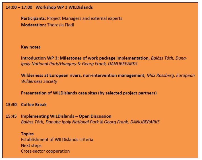
3 Act. 3.1: Danube WILDisland learning process Cross-sector conference DANUBEparksCONNECTED & Danube STREAM April, Dunakiliti, Fertö-Hansag NP Today: discussion WILDisland guidelines (definitions, criterias ) WILDisland Inventory (Danube-wide) Cross-sector conference (2018, Serbia) (organized by Danube STREAM) Today: introduction DANUBEPARKS Contribution to PLATINA 2 Manual on Waterway Maintenance National meetings with waterway sector (each country) Budget: ,55
4 Act. 3.2: Joint Implementation of WILDisland Yesterday: start preparation 5 pilot restoration actions (NPDA, SNC SR, DINPI, Wachau, Persina) Budget: ,50

5 Act. 3.3: Establishing the Danube Wild Island Habitat Corridor Today: internal nomination min. 21 Inseln along the Danube until 2019 Today: brainstorming Online-database for implementation and communication Budget: ,50
6
7

8
9 Act. 3.4: Anchoring WILDisland: capitalisation & follow-up strategy WILDisland Masterplan Today: wilderness at European rivers a perspective from EWS Stakeholder meeting (organized by Danube STREAM, Vienna 2019) Cross-sector Directors Meeting: future Cooperation, follow-up projects, (Budapest 2019) Budget: ,65
10 Definition WILDisland Today s To-do s Today: presentation case sites & Document Establish the WILDisland working group & define its role Online platform: joint understanding, process of contracting Identification of stakeholders on WILDislands (table to be filled in) Short discussion: Platina Manual on Water Maintenance Prepare your pilot actions
11 Definition & Standards General Statement Frame Conditions: WILDisland as flagship habitat for river morphology, dynamics & wilderness and habitat connectivity along the Danube
12 WILDisland: main criterias all semi-aquatic respectively semi-terrestrial structures in/nearby the main course of the river or its large sidechannels, when (regularly) surrounded by water. (type of) vegetation is not a limiting factor but only natural or semi-natural habitat types outcomes of river dynamics and natural processes (also islands altered by human alteration (e.g. forestry) and resulting out of existing river engineering infrastructure (e.g. behind groyne fields) can be included. (nearly) without any human infrastructure
13 WILDisland: main criterias natural habitats for which non-intervention management is an adequate concept in good ecological status, so non-intervention management is to increase habitat quality all semi-aquatic respectively semi-terrestrial structures in/nearby the main course of the river or its large side branches

14
15 Management principles commitment for non-intervention management No forestry & logging, no erection of infrastructure, no river regulation work Exceptions of non-intervention: - human security - needs of common interests (e.g. flood protection) - legally binding interventions - River restoration (aiming to reduce existing human alterations) - does not influence maintenance work in the navigation channel or infrastructure actions downstream or upstream - doesn t influence landownership and corresponding rights and duties - WILDisland concept doesn t touch local activities of local people (angling, camping)

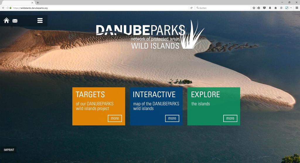
16
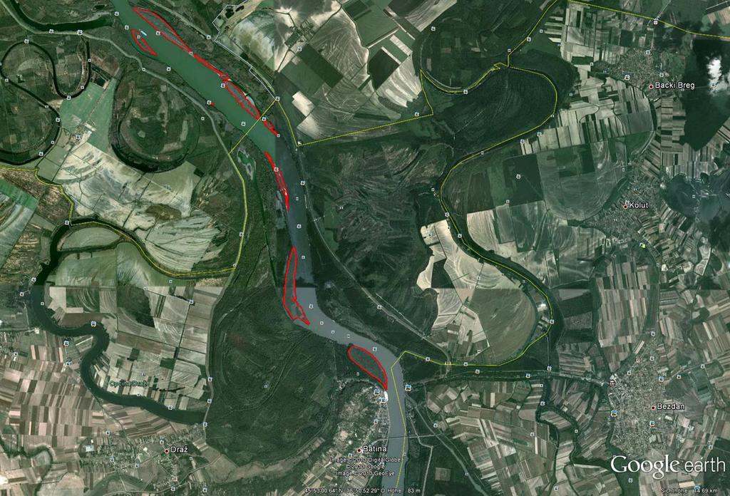
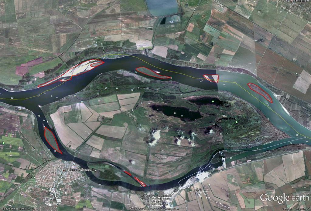
17 Establishing WILDisland - implementation Designation of the islands: based on google earth (different years are to be considered, regular evaluations necessary) step-by-step approach for implementation - Ingolstadt: definition of 1 easy island/region - Commitment until 2019: min. 21 islands (- long-term vision: approx. 500 islands, approx. 9,000 ha)

18
19
20
21
22 Establishing WILDisland - implementation Responsible: DANUBEPARKS working group WILDisland and river morphology Islands included only when all requirements fullfilled agreement on non-intervention management can be reached by. - existing conservation status (e.g. core zon NP, reserves) - additional legally binding conventions - self-binding agreements and statements by the responsible land owners and land users
23 Establishing WILDisland - implementation online database: to establish, to communicate and to promote WILDisland (hosted on including fact sheet of each designated WILDisland, natural values, restoration measure ) Implemenation on the spot together with landowners and land users Evaluation of the process by WILDisland working group 1x per year together with ICPDR & EUSDR (tbc) Supervision: by coordination board
24 WILDisland communication WILDisland is also to be seen as communication tool to promote better conservation of these flagship habitats
25 To-do s (Roadmap) Establish the WILDisland working group (define the role e.g. towards Dunakiliti-conference) How to proceed with the document? (fine tuning in Dunakiliti? signing by Directors? Online platform: joint understanding, process of contracting (DINPI: 7,500 ) Identification of stakeholders (table to be filled in) Short discussion: Platina Manual on Water Maintenance
Sediment project proposal. EUSDR PA4 SG meeting June 9 th Dr. László KARDOSS
 Sediment project proposal EUSDR PA4 SG meeting June 9 th 2015. Dr. László KARDOSS Content Overview of the events Quick glance at the project content Steps to be made Acknowledgements Since the last PA4
Danube Sediment Management Restoration of Sediment Balance in the Danube A still ongoing project preparation
 Annual Steakholder Seminar Protecting the Environment EU SDR Budapest, 6 November, 2012 Danube Sediment Management Restoration of Sediment Balance in the Danube A still ongoing project preparation Values
Sediment management in the Danube River Basin. Igor Liška ICPDR
 Sediment management in the Danube River Basin Igor Liška ICPDR Danube River Protection Convention 29 June 1994, Sofia (Bulgaria) Protection of water & ecological resources Sustainable use of water Reduce
Restoration of the Sediment Balance in the Danube River DanubeSediment. Sándor Baranya, BME
 Restoration of the Sediment Balance in the Danube River DanubeSediment Sándor Baranya, BME Sediment related problems in the Danube River Increasing discrepancy between surplus and deficit of sediment increases
Danube Sediment Management - Restoration of the Sediment Balance in the Danube River th RBM EG Meeting
 Danube Sediment Management - Restoration of the Sediment Balance in the Danube River 2016. 10. 25. 44th RBM EG Meeting Outline Brief history Positioning Preliminary action Partnership Work packages Budget
National Perspectives - Portugal. Margarida Almodovar
 National Perspectives - Portugal Margarida Almodovar margarida.almodovar@mam.gov.pt from base line to the external limit of the continental shelf behind 200 miles and according to UNCLOS definitions Economic
Work Packages. RECROS Project development workshop. Prague, 30 th April 2015
 Work Packages Prague, 30 th April 2015 Main principles - remarks Protected areas, regions, cities, not only comparison cities/rural areas HU most of cities have their climate strategies good contacts to
17 TH RRC ANNUAL NETWORK CONFERENCE. Planning, delivery and evaluation of our rivers: challenges and choices. Tweet us #RRCBlackpool
 17 TH RRC ANNUAL NETWORK CONFERENCE Tweet us #RRCBlackpool Planning, delivery and evaluation of our rivers: challenges and choices We would like to thank the sponsors of the conference who support discounted
Management of Sediment Quality and Quantity in the Danube River Basin
 Management of Sediment Quality and Quantity in the Danube River Basin 5 th SedNet Conference 27-29 May 2008 Oslo (N) Igor Liska ICPDR igor.liska@unvienna.org CONTENT ICPDR & EU WFD implementation Sediment
Marine/Maritime Spatial Planning Andrej Abramić
 Marine/Maritime Spatial Planning Andrej Abramić EcoAqua SUMMER SCHOOL: Ecosystem approach to aquaculture 26-29th of October 2015 Research and Technology to enhance excellence in Aquaculture development
Natura 2000 and spatial planning. Executive summary
 Natura 2000 and spatial planning Executive summary DISCLAIMER The information and views set out in this study are those of the author(s) and do not necessarily reflect the official opinion of the Commission.
»Networking for Ecological Connectivity and Green Infrastructure«
 AlpGov Follow-Up Workshop:»Networking for Ecological Connectivity and Green Infrastructure«By alparc; presented by Jani Bergant, Agricultural Institute of Slovenia, Alpbionet2030 Project Partner PROJECT
WORKSHOP #2 [Modeling and Sediment Transfers Review of alternative solutions] Bucharest 07 October 2015
![WORKSHOP #2 [Modeling and Sediment Transfers Review of alternative solutions] Bucharest 07 October 2015](/thumbs/82/85703998.jpg "WORKSHOP #2 [Modeling and Sediment Transfers Review of alternative solutions] Bucharest 07 October 2015") STUDIU DE FEZABILITATE PENTRU SOLUŢII TEHNICE ALTERNATIVE/COMPLEMENTARE PRIVIND LUCRĂRILE CE SE VOR EXECUTA ÎN PUNCTUL CRITIC 01 BALA DIN CADRUL PROIECTULUI ÎMBUNĂTĂŢIREA CONDIŢIILOR DE NAVIGAŢIE PE DUNĂRE
STUDIU DE FEZABILITATE PENTRU SOLUŢII TEHNICE ALTERNATIVE/COMPLEMENTARE PRIVIND LUCRĂRILE CE SE VOR EXECUTA ÎN PUNCTUL CRITIC 01 BALA DIN CADRUL PROIECTULUI ÎMBUNĂTĂŢIREA CONDIŢIILOR DE NAVIGAŢIE PE DUNĂRE
The National Policy Strategy for Infrastructure and Spatial Planning CODE24 CONFERENCE. Emiel Reiding
 The National Policy Strategy for Infrastructure and Spatial Planning Emiel Reiding Structure of presentation 1. Spatial planning in the Netherlands 2. National Policy Strategy Aims National interests 3.
What is a watershed or landscape perspective?
 What is a watershed or landscape perspective? -remove sediment -add sediment -add wood, riparian manipulation -alter (engineer) channel/floodplain morphology -restore/abandon roads You are here What is
Morphological analysis of Danube basin Black Poplars. Branislav Kovačević
 Morphological analysis of Danube basin Black Poplars Branislav Kovačević European black poplar (Populus nigra L.) - autochthonous and endangered tree species of riparian zones of Danube basin Variability
D2. Addressing tourism related mobility
 14-15 MAY 2018 NICOSIA, CYPRUS D2. Addressing tourism related mobility FROM SUMP TO SRTMP ALONG DANUBE Prof. Lucia Ilieva CSDCS, Bulgaria Agnes Kurzweil Environmental Agency, Austria, Andreas Friedwagner
Mapping and Assessment of Ecosystems and their Services
 Mapping and Assessment of Ecosystems and their Services ALTER-Net Conference 2013: Science underpinning the EU 2020 Biodiversity Strategy. April 2013 Gent Joachim MAES 1 This presentation is based on the
Overview of Methods. Terrestrial areas that are most important for conservation Conservation
 Overview of Methods The goal of the Western Lake Erie Coastal Conservation Vision project (WLECCV) is to define where we should be working locally to optimally achieve regional conservation impact. The
HELSINKI COMMISSION Baltic Marine Environment Protection Commission
 HELSINKI COMMISSION Baltic Marine Environment Protection Commission HELCOM RECOMMENDATION 24/10 Adopted 25 June 2003, having regard to Article 20, Paragraph 1 b) of the 1992 Helsinki Convention IMPLEMENTATION
ESPON SEMINAR «WHERE ARE EUROPEAN CITIES HEADING? EVIDENCE FOR BETTER POLICY-MAKING» 7-8 DECEMBER BRATISLAVA
 ESPON SEMINAR «WHERE ARE EUROPEAN CITIES HEADING? EVIDENCE FOR BETTER POLICY-MAKING» 7-8 DECEMBER 2016 - BRATISLAVA The Region of Abruzzo: facts & figures Total surface: 1.079.512 Ha; Mountains in Abruzzo
ICZM and MSP in the Black Sea Region
 ICZM and MSP in the Black Sea Region Drd. Claudia Coman, Environmental engineer AG ICZM Focal Point, Romania Black Sea Commission Black Sea Commission on the Protection of the Black Sea against Pollution
Marine Spatial Planning as an important tool for implementing the MSFD
 Marine Spatial Planning as an important tool for implementing the MSFD Risto Kalliola Tallinn, Nov. 16 th 2012 DEPARTMENT OF GEOGRAPHY AND GEOLOGY University of Turku, Finland Ten principles to provide
Biodiversity and Protected Areas Management Project
 Biodiversity and Protected Areas Management Project Technical Advisor ESA region: Selwyn Willoughby Coordinator ESA region: Christine Mentzel FlexiCadastre EMEA Regional User Conference, Cape Town, South
DriDanube project. DriDanube Drought Risk in the Danube Region Project co-funded by European Union funds (ERDF, IPA)
") DriDanube project dr. Andreja Sušnik Slovenian Environment Agency Sandor Szalai Szent Istvan University EUSDR PA4 SH Meeting 05 April 2018, Budapest/Hungary DriDanube Drought Risk in the Danube Region
DriDanube project dr. Andreja Sušnik Slovenian Environment Agency Sandor Szalai Szent Istvan University EUSDR PA4 SH Meeting 05 April 2018, Budapest/Hungary DriDanube Drought Risk in the Danube Region
Country Fiche Estonia
 Country Fiche Estonia Updated October 2017 1. General information Size of internal waters (to the baseline) and territorial sea (12-nm zone from the baseline) approximately 25 200 km 2. Exclusive economic
Restoring river-floodplain interconnection and riparian habitats along the embanked Danube between Neuburg and Ingolstadt (Germany)
") Restoring river-floodplain interconnection and riparian habitats along the embanked Danube between Neuburg and Ingolstadt (Germany) Dipl.-Geogr. Gerald Blasch Department of Physical Geography, Cath. University
Restoring river-floodplain interconnection and riparian habitats along the embanked Danube between Neuburg and Ingolstadt (Germany) Dipl.-Geogr. Gerald Blasch Department of Physical Geography, Cath. University
Chapter 14 The technical role of government authorities in watershed management
 Chapter 14 The technical role of government authorities in watershed management 14.1 Objectives and procedural outline 1) Purpose of this chapter as related to participatory watershed management The participatory
EAGLES NEST AND PIASA ISLANDS
 EAGLES NEST AND PIASA ISLANDS HABITAT REHABILITATION AND ENHANCEMENT PROJECT MADISON AND JERSEY COUNTIES, ILLINOIS ENVIRONMENTAL MANAGEMENT PROGRAM ST. LOUIS DISTRICT FACT SHEET I. LOCATION The proposed
GENERAL RECOMMENDATIONS. Session 7. Breakout discussion. discuss on regional and interregional. proposals 1. COLLABORATION BETWEEN PROGRAMMES
 Session 7 24 July 2016, 9.00-11.00 Breakout discussion on regional and interregional joint project proposals Mr Shahbaz Khan summarized the two days of presentations and exchanges and requested the participants
Country Fiche Latvia Updated October 2016
 Country Fiche Latvia Updated October 2016 1. General information Marine area under Latvian jurisdiction includes inland sea waters, Territorial sea (12 nautical miles from the baseline) and exclusive economic
Improvement of navigation conditions on the Danube (Calarasi-Braila and Lower Danube) - Ecological concerns?
 - Ecological concerns?") Improvement of navigation conditions on the Danube (Calarasi-Braila and Lower Danube) - Ecological concerns? Georg Rast, Christine Bratrich, Orieta Hulea WWF Germany/DCPO Topics of the presentation Major
Improvement of navigation conditions on the Danube (Calarasi-Braila and Lower Danube) - Ecological concerns? Georg Rast, Christine Bratrich, Orieta Hulea WWF Germany/DCPO Topics of the presentation Major
Country Fiche Estonia
 Country Fiche Estonia Deleted: October Updated May 2018 Deleted: 7 1. General information Size of internal waters (to the baseline) and territorial sea (12-nm zone from the baseline) approximately 25 200
Ecosystem-Based Approach in MSP
 Ecosystem-Based Approach in MSP 16th Meeting of the joint HELCOM-VASAB Maritime Spatial Planning Working Group Ministry of Environment Aleksanterinkatu 7, Helsinki 8.-9. May 2018 Prof. Dr. jur. Gerold
Stream Restoration and Environmental River Mechanics. Objectives. Pierre Y. Julien. 1. Peligre Dam in Haiti (deforestation)
") Stream Restoration and Environmental River Mechanics Pierre Y. Julien Malaysia 2004 Objectives Brief overview of environmental river mechanics and stream restoration: 1. Typical problems in environmental
Stream Restoration and Environmental River Mechanics Pierre Y. Julien Malaysia 2004 Objectives Brief overview of environmental river mechanics and stream restoration: 1. Typical problems in environmental
Management Planning & Implementation of Communication Measures for Terrestrial Natura 2000 Sites in the Maltese Islands Epsilon-Adi Consortium
 Management Planning & Implementation of Communication Measures for Terrestrial Natura 2000 Sites in the Maltese Islands Epsilon-Adi Consortium Briefing Meetings, February 2013 CT3101/2011, MEPA, Malta
Spatial Planning & Climate Change
 Spatial Planning & Climate Change A GRIP Approach Joseph Scott, Glasgow & Clyde Valley Strategic Development Plan Authority, Scotland Today s presentation Context Spatial Planning & Climate Change Exploring
The Thresholds working Group.
 A Report for the CEESP on the Key Biodiversity Areas (KBA) Delineation Workshop organized by the IUCN during 10-15 March 2013, Front Royal, Virginia, USA. The joint task force of the World Commission of
Land Use in the context of sustainable, smart and inclusive growth
 Land Use in the context of sustainable, smart and inclusive growth François Salgé Ministry of sustainable development France facilitator EUROGI vice president AFIGéO board member 1 Introduction e-content+
Assessment and valuation of Ecosystem Services for decision-makers
 Assessment and valuation of Ecosystem Services for decision-makers An introduction to the ARIES approach Ferdinando Villa *, Ken Bagstad Gary Johnson, Marta Ceroni *Basque Center for Climate Change, Bilbao,
GIS Geographical Information Systems. GIS Management
 GIS Geographical Information Systems GIS Management Difficulties on establishing a GIS Funding GIS Determining Project Standards Data Gathering Map Development Recruiting GIS Professionals Educating Staff
Title: riversnetwork.org : Concept and Tools for sharing Knowledge and Awareness on the River Basins of the World
 Title: riversnetwork.org : Concept and Tools for sharing Knowledge and Awareness on the River Basins of the World Abstract Author: Eric Tilman BASIN PAPER #: 86 riversnetwork.org is an open resource consisting
Maritime Spatial Planning in the Baltic Sea Region
 Maritime Spatial Planning in the Baltic Sea Region Talis Linkaits Head of VASAB Secretariat 20 May 2015 Helsinki A cooperation of ministers of the 11 Baltic Sea Region countries responsible for spatial
GIS Data, Technology, and Models. to Integrate Information and Improve Transportation Decision-Making. within the Eco-Logical* Framework for Oregon
 GIS Data, Technology, and Models to Integrate Information and Improve Transportation Decision-Making within the Eco-Logical* Framework for Oregon GIS-T 2009, Oklahoma City, OK April 8, 2009, Session 5..2.2
Croatian physical planning system and strategic approach to MSP
 W 1/7 Past two years all over the Europe: case studies 2 Croatian physical planning system and strategic approach to MSP Vesna Marohnić Kuzmanović Head of Department Croatian Institute for Spatial Development
1. Baltic SCOPE Towards coherence and cross-border solutions in Baltic Maritime Spatial Plans
 NSHC 32th Conference Explanatory Note Dublin, Ireland Item E.2 MSP 21-23 June 2016 Germany Cross border MSP for the EEZ, a case study from the Baltic Sea The Federal Maritime and Hydrographic Agency of
16540/14 EE/cm 1 DG E 1A
 Council of the European Union Brussels, 5 December 2014 (OR. en) 16540/14 ENV 965 CULT 139 NOTE From: To: Subject: General Secretariat of the Council Delegations Charter of Rome on Natural and Cultural
The production and use of a hydrographic flow-direction network of surface waters. Rickard HALLENGREN, Håkan OLSSON and Erik SISELL, Sweden
 The production and use of a hydrographic flow-direction network of surface waters Rickard HALLENGREN, Håkan OLSSON and Erik SISELL, Sweden Key words: hydrographic, flow-direction network, surface waters
The SedAlp Project: WP6: INTERACTION WITH STRUCTURES
 The SedAlp Project: WP6: INTERACTION WITH STRUCTURES 6 th International conference Water in the Alps Herrenchiemsee, 12 th of October, 2016 Jošt Sodnik Contents Structure of SedAlp project (www.sedalp.eu)
MEMORANDUM OF UNDERSTANDING FOR THE ESTABLISHMENT OF A CARPATHIAN INTEGRATED BIODIVERSITY INFORMATION SYSTEM
 MEMORUM OF UNDERSTING FOR THE ESTABLISHMENT OF A CARPATHIAN INTEGRATED BIODIVERSITY INFORMATION SYSTEM BETWEEN DAPHNE - INSTITUTE OF APPLIED ECOLOGY (hereinafter referred to DAPHNE) EUROPEAN ACADEMY BOLZANO
REGIONAL SDI DEVELOPMENT
 REGIONAL SDI DEVELOPMENT Abbas Rajabifard 1 and Ian P. Williamson 2 1 Deputy Director and Senior Research Fellow Email: abbas.r@unimelb.edu.au 2 Director, Professor of Surveying and Land Information, Email:
INSPIRE Basics. Vlado Cetl European Commission Joint Research Centre. https://ec.europa.eu/jrc/
 INSPIRE Basics Vlado Cetl European Commission Joint Research Centre https://ec.europa.eu/jrc/ Serving society Stimulating innovation Supporting legislation Outline SDI? Why European SDI? INSPIRE Policy
Strengthening the cooperation in the region: Carpathian, Tisa,, Danube and Black Sea areas
 Strengthening the cooperation in the region: Carpathian, Tisa,, Danube and Black Sea areas 14th October 2009 SEE Annual Conference Advancing development through transnational cooperation in South East
Adaptation to Climate Change in other Mountain Regions
 Adaptation to Climate Change in other Mountain Regions First Working Group of the Carpathian Convention on Adaptation to Climate Change Brussels, 4-5 February 2012 Pictures: A. Czaderna, A.& D. Nowak,
Factors that Shape Places (Blacktown) Stage 3 Geography
 Stage 3 Geography") Factors that Shape Places (Blacktown) Stage 3 Geography Summary This unit is written for Stage 3 "Factors that shape places". It is a Geographical Inquiry, enabling students to work through the 3 stages
Factors that Shape Places (Blacktown) Stage 3 Geography Summary This unit is written for Stage 3 "Factors that shape places". It is a Geographical Inquiry, enabling students to work through the 3 stages
CND Intersessional Meeting 17 October Precursors Control Section Secretariat of the International Narcotics Control Board (INCB)
") Operational Recommendations on cross-cutting issues in addressing and countering the world drug problem: INCB follow-up activities on Chapter 5: NPS, precursors and pre-precursors CND Intersessional Meeting
Operational Recommendations on cross-cutting issues in addressing and countering the world drug problem: INCB follow-up activities on Chapter 5: NPS, precursors and pre-precursors CND Intersessional Meeting
The Imperative of Sediment Management Concepts in River Basin Management Plans
 The Imperative of Sediment Management Concepts in River Basin Management Plans Stefan Vollmer, Thomas Hoffmann, Gudrun Hillebrand, Ina Quick, Axel Winterscheid Department M3 Groundwater, Geology, River
Biodiversity Blueprint Overview
 Biodiversity Blueprint Overview Climate Variability Climate projections for the Glenelg Hopkins Regions suggest that the weather will be hotter and drier in the coming years which will impact on land use,
The Danube River. Hydrological Connectivity and Human Influence. By: Pat O Connell, Pat Wilkins, Tiana Royer, and Kevin Gaitsch
 The Danube River Hydrological Connectivity and Human Influence By: Pat O Connell, Pat Wilkins, Tiana Royer, and Kevin Gaitsch Danube River Characteristics Length: 2860 km Drainage Area: 816,000 km 2 Peak
MESMA: An integrated tool box to support an ecosystem based spatial management of marine areas
 MESMA: An integrated tool box to support an ecosystem based spatial management of marine areas Stelzenmüller, V., Stamford, T., Vassilopoulou, V., Kastanevakis, S., Vincx, M, Vanaverbeke, J., Rabaut, M.,
Plan4all (econtentplus project)
") Plan4all (econtentplus project) Karel CHARVAT 1, Tomáš MILDORF 2 1 Help service remote sensing, Ltd., Černoleská 1600, 256 01 Benešov u Prahy, Czech Republic charvat@bnhelp.cz 2 Department of Mathematics
Plan4all (econtentplus project) Karel CHARVAT 1, Tomáš MILDORF 2 1 Help service remote sensing, Ltd., Černoleská 1600, 256 01 Benešov u Prahy, Czech Republic charvat@bnhelp.cz 2 Department of Mathematics
Open spatial data infrastructure
 Open spatial data infrastructure a backbone for digital government Thorben Hansen Geomatikkdagene 2018 Stavanger 13.-15. mars Spatial Data Infrastructure definition the technology, policies, standards,
The Green. Chemistry Checklist Why Green Chemistry? The Business Case. Inside. Support and Communication. Design and Innovation
 The Green Chemistry Checklist Green Chemistry and Safer Products Business Commitment, v.1.0 Why Green Chemistry? The Business Case Inside Why Use the Green Chemistry Checklist page 2 The Checklist: Green
Mediteranean sea issues in the view of ESPON ESaTDOR project and Marine Spatial Planning in Slovenia
 DIREKTORAT ZA PROSTOR, GRADITEV IN STANOVANJA Mediteranean sea issues in the view of ESPON ESaTDOR project and Marine Spatial Planning in Slovenia BlueMed meeting of stakeholders on a micro-regional level
Navigable maritime and river waterways in the seaside - Danube Delta area and the connected rural development
 SUMMARY OF Ph-D Thesis, with title RESEARCH STUDIES ON MANAGEMENT IMPROVEMENT OF MARITIME AND RIVER TRANSPORT ACTIVITY IN THE COASTAL AND DANUBE DELTA AREA FROM AN ENVIROMENTAL, ECONOMIC AND SOCIAL PERSPECTIVE
CONFERENCE STATEMENT
 Final draft CONFERENCE STATEMENT We, the elected representatives of Canada, Denmark/Greenland, the European Parliament, Finland, Iceland, Norway, Russia, Sweden and the United States of America; In collaboration
Land Use Planning and Agriculture: Austrian Experiences and Challenges I
 Land Use Planning and Agriculture: Austrian Experiences and Challenges I SULANET Summer School 2016 Walter Seher BOKU Vienna 1 Land Use Planning and Agriculture 2 Land Use Planning and Agriculture Agriculture
The Swedish National Geodata Strategy and the Geodata Project
 The Swedish National Geodata Strategy and the Geodata Project Ewa Rannestig, Head of NSDI Co-ordination Unit, Lantmäteriet, ewa.rannstig@lm.se Ulf Sandgren, Project Manager Geodata Project, Lantmäteriet,
Planning for the Shoreline
 Planning for the Shoreline A Summary of the roundtable discussion at Georgia Strait Alliance s second Waterfront Forum June 23, 2014 SFU Harbour Centre Vancouver, BC Planning for the Shoreline Georgia
PROPOSED UNESCO FUNDY BIOSPHERE RESERVE
 OVERVIEW PROPOSED UNESCO FUNDY BIOSPHERE RESERVE NEW BRUNSWICK, CANADA NOMINATION DOCUMENT April 10, 2007 The United Nations Educational, Scientific and Cultural Organization (UNESCO) Man and the Biosphere
Global Monitoring for Environment and Security (GMES)
") Global Monitoring for Environment and Security (GMES) Satellite Earth Observation for the Emergency Services Dr Nick Veck Presentation to the G-STEP Launch Univ. of Leicester 19 th June 2009 Contents of
Global Monitoring for Environment and Security (GMES) Satellite Earth Observation for the Emergency Services Dr Nick Veck Presentation to the G-STEP Launch Univ. of Leicester 19 th June 2009 Contents of
Continental Divide National Scenic Trail GIS Program
 CDNST Vision Statement: Provide the most accurate geospatial locational information of the Continental Divide Trail and nearby resources to the public as well as help provide internal management information
THE SEVILLE STRATEGY ON BIOSPHERE RESERVES
 THE SEVILLE STRATEGY ON BIOSPHERE RESERVES 1 VISION FOR BIOSPHERE RESERVES IN THE 21 ST CENTURY The international Seville Conference on Biosphere Reserves, organised by UNESCO, adopted a two-pronged approach,
Public Disclosure Copy. Implementation Status & Results Report Ghana FIP - Enhancing Natural Forest and Agroforest Landscapes Project (P148183)
") Public Disclosure Authorized AFRICA Ghana Environment & Natural Resources Global Practice Recipient Executed Activities Investment Project Financing FY 2015 Seq No: 6 ARCHIVED on 19-Dec-2017 ISR30434 Implementing
Public Disclosure Authorized AFRICA Ghana Environment & Natural Resources Global Practice Recipient Executed Activities Investment Project Financing FY 2015 Seq No: 6 ARCHIVED on 19-Dec-2017 ISR30434 Implementing
Floods 2014 a wake up call to natural hazards
 Floods 2014 a wake up call to natural hazards Floods affected 119 municipalities (out of 165) 22% of total population affected by floods More than 30 municipalities sustained extensive damage 57 lives
WHERE THE MONEY COME FROM? ECONNECT project is financed with ,00 by
 THE STARTING POINT WHERE THE MONEY COME FROM? ECONNECT project is financed with 3.198.240,00 by WHO? The partnership is composed by 16 partners: AUSTRIA -University of Veterinary Medicine of Vienna Research
Current Research Trends from an Australian Perspective. Dr Philip Collier Research Director
 Current Research Trends from an Australian Perspective Dr Philip Collier Research Director Growth in the spatial sector. 11% pa in the Global Navigation Satellite System market 2010-2020 300% growth in
Other effective area based conservation. The case of Colombia
 Other effective area based conservation measures (OECM): The case of Colombia Working group on Complementary Conservation Strategies Clara L. Matallana Humboldt Institute How is Colombia regarding Aichi
Sediment management: a european perspective. Piet den Besten Centre for Water Management Rijkswaterstaat, Netherlands
 Sediment management: a european perspective Piet den Besten Centre for Water Management Rijkswaterstaat, Netherlands Content Background of Dutch-German exchange (DGE plus) What is needed for adequate sediment
VISION FOR THE FUTURE: Marine Spatial Planning in Belgium
 VISION FOR THE FUTURE: Marine Spatial Planning in Belgium Fanny Douvere, Consultant Intergovernmental Oceanographic Commission UNESCO, Paris, France PlanCoast Conference on Marine Spatial Planning Supetar
Bratislava Umland Management
 Bratislava Umland Management Coordination of the spatial development of the city of Bratislava and the neighboring Austrian municipalities Metropolisation of River basins, between threats and opportunities
Wetland Programmes. Biodiversity assessments in determining wetland conservation priorities: a catchment approach. Dr. Piet-Louis Grundling
 CHIEF DIRECTORATE NATURAL RESOURCE MANAGEMENT PROGRAMMES: Wetland Programmes Biodiversity assessments in determining wetland conservation priorities: a catchment approach Dr. Piet-Louis Grundling Environmental
Jordan's Strategic Research Agenda in cultural heritage
 Jordan's Strategic Research Agenda in cultural heritage Analysis of main results Alessandra Gandini Amman, Jordan 3 rd November 2013 Main objectives The work performed had the main objective of giving
WELCOME & INTRODUCTION
 MPA Management Capacity Building Training Module 1: WELCOME & INTRODUCTION Participants Distinguished Guests Welcome Site Overviews of MPAs represented Overview of Training Program What are Today s Objectives?
MISSOURI LiDAR Stakeholders Meeting
 MISSOURI LiDAR Stakeholders Meeting East-West Gateway June 18, 2010 Tim Haithcoat Missouri GIO Enhanced Elevation Data What s different about it? Business requirements are changing.fast New data collection
Kyoto and Carbon Initiative - the Ramsar / Wetlands International perspective
 Kyoto and Carbon Initiative - the Ramsar / Wetlands International perspective (the thoughts of Max Finlayson, as interpreted by John Lowry) Broad Requirements Guideline(s) for delineating wetlands (specifically,
Maritime Spatial Planning: Transboundary Cooperation in the Celtic Seas Looking Ahead
 Maritime Spatial Planning: Transboundary Cooperation in the Celtic Seas Looking Ahead Looking ahead MSP in the context of the European Maritime and Fisheries Fund (EMFF) and beyond SIMCelt Final Conference
Turkey National Report
 UNITED NATIONS Working Paper GROUP OF EXPERTS ON No. 26 GEOGRAPHICAL NAMES Twenty-third Session Vienna, 28 March 4 April 2006 Item 5 of the Provisional Agenda: Reports of the division Turkey National Report
Upper Drac River restoration project
 Upper Drac River restoration project Restoration of a braided river bed incised in clay substratum through sediment reloading and bed widening SHF Conference, Nantes, 6 & 7 october 2014 Small scale morphological
Issues in bryophyte conservation and research
 Issues in bryophyte conservation and research Paula Warren Head Office Wellington Craig Miller West Coast Conservancy Hokitika Published by Head Office, PO Box 10-420 Wellington, New Zealand This report
Biophysical Interactions
 1 River Ecology Senior Geography Biophysical Interactions Checking the Pulse of the Hawkesbury River Name 2 River Ecology Senior Geography Senior Geography Outcomes PRELIMINARY COURSE OUTCOMES P2 describes
Environmental. Plan Update. By Jodie Pavlica
 E i t l and d Environmental Recreational Analysis Snake Salt Basin Plan Update By Jodie Pavlica i for f oday s d Presentation P t ti opics 1. 2. 3. 4. 5. 6. Recreational and Environmental Uses in the Last
River basin management in a transboundary context: Norwegian experience
 River basin management in a transboundary context: Norwegian experience Mrs Bente Christiansen Head of Department on Environment Affairs, Office of the County Governor of Finnmark, Norway Norwegian Chair
An Update on Land Use & Land Cover Mapping in Ireland
 An Update on Land Use & Land Cover Mapping in Ireland Progress Towards a National Programme Kevin Lydon k.lydon@epa.ie Office of Environmental Assessment, Environmental Protection Agency, Johnstown Castle,
PROGRESS REPORT ON APPROACH PAPER THE IMPLEMENTATION OF THE GEF KNOWLEDGE MANAGEMENT. GEF/C.49/Inf.04 September 23, 2015
 49 th GEF Council Meeting October 20 22, 2015 Washington, D.C. GEF/C.49/Inf.04 September 23, 2015 PROGRESS REPORT ON THE IMPLEMENTATION OF THE GEF KNOWLEDGE MANAGEMENT APPROACH PAPER TABLE OF CONTENTS
Geospatial workflows and potential applications to the Sustainable Development Goals of countries in West Asia
 Geospatial workflows and potential applications to the Sustainable Development Goals of countries in West Asia Ameer Abdulla, PhD Senior Advisor, European Topic Center for Spatial Analysis, Spain Associate
KENYA NATIONAL BUREAU OF STATISTICS Workshop on
 KENYA NATIONAL BUREAU OF STATISTICS Workshop on Capacity Building in Environment Statistics: the Framework for the Development of Environment Statistics (FDES 2013) Coordination with Sector Ministries
A Regional Database Tracking Fire Footprint Each Year within the South Atlantic Region: Current Database Description and Future Directions
 A Regional Database Tracking Fire Footprint Each Year within the South Atlantic Region: Current Database Description and Future Directions Last Updated on September 30, 2018 Contributors: NatureServe,
West-Estonian Archipelago Biosphere Reserve and Lima Action Plan
 West-Estonian Archipelago Biosphere Reserve and Lima Action Plan Lia Rosenberg, BR co ordinaator Toomas Kokovkin, MAB Focal Point ESTONIA 15.03.2016 LIMA Location on the globe and Europe The West-Estonian
Strategies for managing sediment in dams. Iwona Conlan Consultant to IKMP, MRCS
 Strategies for managing sediment in dams Iwona Conlan Consultant to IKMP, MRCS 1 Sediment trapping by dams Active storage capacity Dead storage coarse material (bed load) Fine materials (suspension) Francis