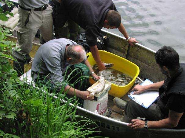
Katarina Holubova & Franz Steiner. Joint efforts for cross-border restoration of the Morava river
|
|
|
- Damon Shelton
- 6 years ago
- Views:
Transcription


1 Katarina Holubova & Franz Steiner Joint efforts for cross-border restoration


2 BACKGROUND INFORMATION AUSTRIA LOCALITY THE MORAVA RIVER IS THE DANUBE LEFT SIDE TRIBUTARY IN THE LENGTH OF 70 KM FORMS INTERNATIONALLY BORDER BETWEEN AUSTRIA AND SLOVAKIA SLOVAKIA RIVER CHARACTER LOWLAND RIVER WITH LOW SLOPE, MOBILE SANDY-GRAVEL BED. THE RIVER CREATES WETLAND ECOSYSTEM - UNIQUE IN CENTRAL EUROPE INCLUDING RAMSAR SITES RIVER REGULATION REGULATION FOR NAVIGATION PURPOSES & FLOOD PROTECTION
3 Danube effect degradation of the river bed Dyje tributary MAIN REGULATION MEASURES: - FINALISING OF FLOOD DYKES - CUT OFF MEANDERS, RIVER LENGTH SHORTENING CREATION OF THE UNIFORM CHANNEL HARD BANK REVETMENT IMPACTS OF THE RIVER REGULATION: [m n.m.] , , , , ,5 HPV HPV terén - DEGRADATION OF RIVER BED (up( to 1.5 m) - SURFACE & GROUND WATER LEVELS DECREASE - CHANGES IN FLOW DYNAMICS Q BANK Q SEDIMENATION IN THE FLOODPLAIN, COLMATATION IN CUT-OFF MEANDERS - CHANGES IN THE STRUCTURE OF WATER BIOTA [datum] trend (16) - SUCCESSIVE DEGRADATION OF CUT-OFF MEANDERS OXBOW LAKES
4 PRESENT STATE OF THE RIVER CHANNEL & FLOODPLAIN DISCONNECTION OT THE RIVER AND FLOODPLAIN PROCESSES UNIFORM RIVER CHANNEL LOST NATURAL CHARACTER OF THE MEANDERING RIVER LIMITED FLOW INTERACTION BETWEEN THE OXBOW SYSTEM AND RIVER CHANNEL INTENSIVE FLOODPLAIN SEDIMENT DEPOSITION IN THE MEANDERS, REDUCTION OF FLOODPLAIN CAPACITY SUCCESSIVE DEGRADATION OF THE MEANDER'S ECOSYSTEM
5 OVER 300 YEARS NO IMPACT ANALYSES OF THE RIVER REGULATION ON ENVIRONMENTAL AND RIVER PROCESSES WERE DONE ECOLOGICAL WORSENING OF THE PRESENT STATE HAS LED TO: SEVERAL INDIPENDENT RESTORATION PROJECTS SK - AT THE MAIN AIM: : RESTORATION SOME OF DISAPPEARING NATURAL RIVER FUNCTIONS AND PRESERVATION OF THE OXBOW SYSTEM AGAINST SUCCESSIVE DEGRADATION SOME OF THE GENERAL AIMS: - increasing of hydrological connectivity, - cut-off meanders reconnection/integration integration, preservation & restoration of the original character of meandering river; - reduction of river bed decrease, - increasing habitat diversity of the uniform river channel; - enhacement and restoration of wetland diversity; - restoration of previous floodplain & floodplain protection
6 1994 AT + SK JOINED RAMSAR CONVENTION Formulation of ecological requirements for the Morava river and floodplain (Ramsar sites) MARTHA PROJECT Austrian - project Analyses of engineer.. & ecological status of the river and floodplain (N) MUF PROJECT planning and implementation of restoration measures including abio and bio monitoring (EU LIFE + N) BGM I INTERREG III A Natura 2000, WFD investigations, observations, analyses, first common concept for the Morava restoration strategy (EU + N) GEF Biodiversity Program Global Environment Facility Restoration measures in cut-off meanders implementation measures (World Bank) REMORAVA PROJECT River and environmental processes, abiotic and biotic response to the river regulation (N- SK Government) PHARE PROJECT 1999 Trilateral project- SK part: ImprovementI of implemented restoration measures & basis for restoration strategy (EU) APVV Compilation of investigations and research results, bio & abio monitoring of implemented mesures, first common concept for the Morava restoration strategy (N) Some of the measures were implemented with various effectiveness
 erosion (-) sedimentation (+) 12000 10000 1996-1999 8000 Meander DVII-")


7 SLOVAK SIDE CUT-OFF MEANDERS RECONECTION Cut-off meanders were reopened on both sides of the river - to reestablish species richness (4 - on the Slovak side,2-on the Austrian side) erosion (-) sedimentation (+) Meander DVII- km cross section number In this case- restoraion measures have resulted in significant deposition at all localities as they were done without understanding of river processes Highest sedimention rates were observed in cut-off meanders reconnected at both ends RESULTS: LOW EFFECTIVENESS, RAPID SEDIMATATION, OWERALL ABIO & BIO SITATE INTFLOW present state OUTFLOW present state

: TO IMPROVE WATER REGIME IN OXBOW LAKES LARGE DEFLECTORS ON SK")


8 AUSTRIAN SIDE Joint efforts for cross-border restoration LOCAL RESTORATION MEASURES: SYSTEM OF SMALL GROYNES -TO INCREASE HABITAT DIVERSITY IN THE MAIN RIVER CHANNEL MEANDER RECONNECTION LOWER PART (OUT- FLOW): TO IMPROVE WATER REGIME IN OXBOW LAKES LARGE DEFLECTORS ON SK RIVER SIDE TO DIVERT FLOW INTO REOPENED MEANDERS S AND REDUCE SEDIMENT INPUT BANKS PAVEMENT REMOVAL TO INICIATE LATERAL DEVELOPMENT AND INCREASE LATERAL CONNECTIVITY IMPLEMENTED MEASURES mostly local character, lower efficiency highlighted the need of join procedure in preparation of the common restoration startegy
9 PROJECT BGM II-(2006 ( ) 2007) THE FIRST COMMON RESTORATION STRATEGY FOR SLOVAK AUSTRIAN SECTION OF THE MORAVA RIVER PREPARED ACCORDING REQIREMENTS OF WATER FRAMEWORK DIRECTIBE AND EU DIRECTIVES ABOUT WATER AND NATURE PROTECTION BASIC ASSUMPTION: ASSESMENT OF THE RIVER & FLOODPLAIN WITHIN ONE RIVER SYSTEM REGARDLESS OF THE STATE BORDER OUTPUT: BILATERAL PLAN OF RESTORATION MEASURES FOR SLOVAK AUSTRIAN SECTION OF THE MORAVA RIVER
 UNSTABLE SECTION (km 15 km 20)")


10 MORFOLOGICAL DEVELOPMENT HISTORICAL MAPS STABLE SECTION (km 27 km 33) UNSTABLE SECTION (km 15 km 20) SK ATSECTION INCLUDES: -STABLE SECTIONS (with low morphological dynamics the river channel has low sinousity,, over the many years the lateral activity is limited) -UNSTABLE (high morpholo- gical dynamics high lateral activity creation and extinction of meanders) BACKGROUND FOR THE RESTORATION DESIGNS Morphological clasification and river characterization enable to understand the river behaviour and to avoid proposals of measures that is not typical for given river type


11 BGM II Extensive abiotic and biotic investigation was curried out


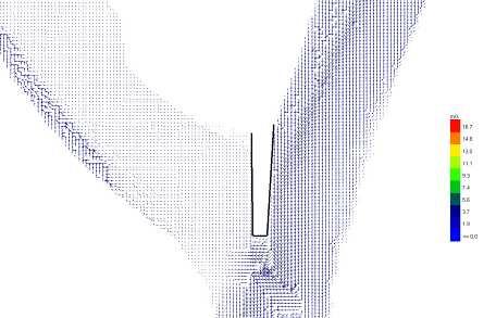
12 BGM II Analyses of the river processes using 1D, 2D numerical models


13 BGM II PHYSICAL MODEL WITH MOBILE RIVER BED USED FOR ANALYSES OF VARIOUS SCENRIOS OF MEANDERS RECONNECTION
14 Joint efforts for cross-border restoration BGM II - PLAN OF MEASURES COMPLEX LIST OF RESTORATION MEASURES FOR THE RIVER CHANNEL & FLOODPLAIN (INCLUDING CUTOFF MEANDERS)FOR WHOLE SLOVAK AUSTRIAN RIVER SECTION EVALUATION OF THE MEASURES IMPACT IN RELATION TO REQUIREMENTS INCLUDED IN EU DIRECTIVES ABOUT WATER & NATURE PROTECTION (WFD 2000/60/EC, Natura 2000, Ramsar, Ramsar, Habitat and Bird Directive, Directive, etc.) etc.) FIRST FINANCIAL COSTS ESTIMATION (implementation) implementation)
 FOR THE PILOT SECTION OF THE RIVER")
15 BGM II Joint efforts for cross-border restoration MORAVA RIVER RESTORATION: PLAN OF MEASURES PREPARED ACCORDING REQIREMENTS OF EU DIRECTIVES ABOUT WATER AND NATURE PROTECTION MoRe - THE MAIN PROJECT GOLAS DETAIL PROPOSAL OF RESTORATION MEASURES PREPARED ACCORDING REQUIREMENTS OF EU DIRECTIVES(RSV RSV 2000/60/EC, Natura 2000, Habitat & Birds Directives, Ramsar) FOR THE PILOT SECTION OF THE RIVER (km 69-km 53) WITH THE AIM TO ACHIEVE GES, the concept to SK AT Border Commission BIOTIC AND BIOTIC MONITORINGM - PRIOR IOR-IMPLEMENTATIONIMPLEMENTATION PLANNING DOCUMENTATION FOR ALL PROPOSED AND APROVED RESTORATION MEASURES (pilot section) PREPARATION OF THE PROJECT IMPLEMENTATION
 FLOODPLAIN (including cut-offs offs) 2) CHANNEL,")


16 PILOT SECTION OF THE MORAVA RIVER km 69 km 53 RESTORATION MEASURES: 1) FLOODPLAIN (including cut-offs offs) 2) CHANNEL, RIVER BANKS & RIVERINE ZONE MEASURES 1 (floodplain( floodplain): - MEANDERS RECONNECTION (hydrological conectivity, controled lateral development) a) full integration b) reconnection on the lower end - IMPROVEMENT OF FLOODPLAIN CAPACITY WITHIN THE PRESENT FLOODPLAIN


 - BANK LEVEL")
 -")
17 Pilot section AT SK MEASURES 2 (channel( channel, banks & riverine zone): - REMOVAL OF BANK PAVEMENT - localy - IMPROVEMENT OF WATER REGIME IN MEANDERS RELICTS (lateral( conectivity) - BANK LEVEL DECREASE localy - to enhanced water interaction channel & floodplain) - RIVER CONTINUITY TRIBUTARIES

18 Thank you for your attention DANUBEPARKS International Workshop River Morphology & Restoration Orth,, 26th 27th May 2011
Pilot-Project Project Bad Deutsch Altenburg:
 Pilot-Project Project Bad Deutsch Altenburg: River Restoration and Prevention of Riverbed-Erosion in the Danube Floodplain National Park (Austria) Stefan Schneeweihs Mohács, 2013 11 18 Pictures: F. Kovacs,
Improvement of navigation conditions on the Danube (Calarasi-Braila and Lower Danube) - Ecological concerns?
 - Ecological concerns?") Improvement of navigation conditions on the Danube (Calarasi-Braila and Lower Danube) - Ecological concerns? Georg Rast, Christine Bratrich, Orieta Hulea WWF Germany/DCPO Topics of the presentation Major
Improvement of navigation conditions on the Danube (Calarasi-Braila and Lower Danube) - Ecological concerns? Georg Rast, Christine Bratrich, Orieta Hulea WWF Germany/DCPO Topics of the presentation Major
Wetland & Floodplain Functional Assessments and Mapping To Protect and Restore Riverine Systems in Vermont. Mike Kline and Laura Lapierre Vermont DEC
 Wetland & Floodplain Functional Assessments and Mapping To Protect and Restore Riverine Systems in Vermont Mike Kline and Laura Lapierre Vermont DEC NWI+ Hydro-Geomorphic Characterization of Wetlands and
Removal of riverbank protection along the River Rhine (the Netherlands)
") RR 2004 3rd European Conference on River Restoration RIVER RESTORATION 2004 Zagreb, Croatia, 17-21 May 2004 Removal of riverbank protection along the River Rhine (the Netherlands) L.J. Bolwidt, H.E.J.
RR 2004 3rd European Conference on River Restoration RIVER RESTORATION 2004 Zagreb, Croatia, 17-21 May 2004 Removal of riverbank protection along the River Rhine (the Netherlands) L.J. Bolwidt, H.E.J.
Danube Sediment Management Restoration of Sediment Balance in the Danube A still ongoing project preparation
 Annual Steakholder Seminar Protecting the Environment EU SDR Budapest, 6 November, 2012 Danube Sediment Management Restoration of Sediment Balance in the Danube A still ongoing project preparation Values
WORKSHOP #2 [Modeling and Sediment Transfers Review of alternative solutions] Bucharest 07 October 2015
![WORKSHOP #2 [Modeling and Sediment Transfers Review of alternative solutions] Bucharest 07 October 2015](/thumbs/82/85703998.jpg "WORKSHOP #2 [Modeling and Sediment Transfers Review of alternative solutions] Bucharest 07 October 2015") STUDIU DE FEZABILITATE PENTRU SOLUŢII TEHNICE ALTERNATIVE/COMPLEMENTARE PRIVIND LUCRĂRILE CE SE VOR EXECUTA ÎN PUNCTUL CRITIC 01 BALA DIN CADRUL PROIECTULUI ÎMBUNĂTĂŢIREA CONDIŢIILOR DE NAVIGAŢIE PE DUNĂRE
STUDIU DE FEZABILITATE PENTRU SOLUŢII TEHNICE ALTERNATIVE/COMPLEMENTARE PRIVIND LUCRĂRILE CE SE VOR EXECUTA ÎN PUNCTUL CRITIC 01 BALA DIN CADRUL PROIECTULUI ÎMBUNĂTĂŢIREA CONDIŢIILOR DE NAVIGAŢIE PE DUNĂRE
Restoring river-floodplain interconnection and riparian habitats along the embanked Danube between Neuburg and Ingolstadt (Germany)
") Restoring river-floodplain interconnection and riparian habitats along the embanked Danube between Neuburg and Ingolstadt (Germany) Dipl.-Geogr. Gerald Blasch Department of Physical Geography, Cath. University
Restoring river-floodplain interconnection and riparian habitats along the embanked Danube between Neuburg and Ingolstadt (Germany) Dipl.-Geogr. Gerald Blasch Department of Physical Geography, Cath. University
Sediment management in the Danube River Basin. Igor Liška ICPDR
 Sediment management in the Danube River Basin Igor Liška ICPDR Danube River Protection Convention 29 June 1994, Sofia (Bulgaria) Protection of water & ecological resources Sustainable use of water Reduce
How Do Human Impacts and Geomorphological Responses Vary with Spatial Scale in the Streams and Rivers of the Illinois Basin?
 How Do Human Impacts and Geomorphological Responses Vary with Spatial Scale in the Streams and Rivers of the Illinois Basin? Bruce Rhoads Department of Geography University of Illinois at Urbana-Champaign
Technical note about the monitoring of hydromorphological restoration/management of the Drava River in Slovenia
 Technical note about the monitoring of hydromorphological restoration/management of the Drava River in Slovenia 1 Project: HyMoCARES Work package: WPC. Communication Activity: Web Site Deliverable: Case
Assessment. Assessment
 2001 SPRINGBROOK CREEK RESTORATION - THREE YEAR POST-CONSTRUCTION REVIEW - Presented by Bruce Henderson and Andy Harris 2005 River Restoration Northwest Symposium Skamania Lodge, Washington www.hendersonlandservices.com
Why Stabilizing the Stream As-Is is Not Enough
 Why Stabilizing the Stream As-Is is Not Enough Several examples of alternatives to the County s design approach have been suggested. A common theme of these proposals is a less comprehensive effort focusing
Fact sheet: Glacial rivers (all Europe)
") Fact sheet: Glacial rivers (all Europe) General description Valleyplanform Hydrology and The valley form varies from a gorge to a V-shaped valley and the single-thread channel is mainly characterized by
Fact sheet: Glacial rivers (all Europe) General description Valleyplanform Hydrology and The valley form varies from a gorge to a V-shaped valley and the single-thread channel is mainly characterized by
Stream Restoration and Environmental River Mechanics. Objectives. Pierre Y. Julien. 1. Peligre Dam in Haiti (deforestation)
") Stream Restoration and Environmental River Mechanics Pierre Y. Julien Malaysia 2004 Objectives Brief overview of environmental river mechanics and stream restoration: 1. Typical problems in environmental
Stream Restoration and Environmental River Mechanics Pierre Y. Julien Malaysia 2004 Objectives Brief overview of environmental river mechanics and stream restoration: 1. Typical problems in environmental
Hydrologic Analysis for Ecosystem Restoration
 Hydrologic Analysis for Ecosystem Restoration Davis, California Objectives: To provide participants with: 1) an understanding of the issues in restoration studies; 2) an overview of Corps policies and
THE WATER FRAMEWORK DIRECTIVE - Stage of the implementation in Romania. National Administration Apele Romane / Romanian Waters
 THE WATER FRAMEWORK DIRECTIVE - Stage of the implementation in Romania National Administration Apele Romane / Romanian Waters Valencia / Spain,, 11-12 12 November 2003 IMPLICATIONS OF THE WFD IMPLEMENTATION
!"#$%&&'()*+#$%(,-./0*)%(!
*+#$%(,-./0*)%(!") 8:30 Sign in Hoosic River Revival Coalition!"#$%&&'()*+#$%(,-./0*)%(! 12-#30+4/#"5-(60 9:00 Welcome and Introductions 9:15 Goals for Today s Program: A Description of the Planning Process 9:30 First Session:
8:30 Sign in Hoosic River Revival Coalition!"#$%&&'()*+#$%(,-./0*)%(! 12-#30+4/#"5-(60 9:00 Welcome and Introductions 9:15 Goals for Today s Program: A Description of the Planning Process 9:30 First Session:
Landscape Development
 Landscape Development Slopes Dominate Natural Landscapes Created by the interplay of tectonic and igneous activity and gradation Deformation and uplift Volcanic activity Agents of gradation Mass wasting
Influence of the Major Drainages to the Mississippi River and Implications for System Level Management
 Influence of the Major Drainages to the Mississippi River and Implications for System Level Management Brian M. Vosburg Geologist Louisiana Coastal Protection and Restoration Authority brian.vosburg@la.gov
Earth Science Chapter 6 Section 2 Review
 Name: Class: Date: Earth Science Chapter 6 Section Review Multiple Choice Identify the choice that best completes the statement or answers the question. 1. Most streams carry the largest part of their
The Danube River. Hydrological Connectivity and Human Influence. By: Pat O Connell, Pat Wilkins, Tiana Royer, and Kevin Gaitsch
 The Danube River Hydrological Connectivity and Human Influence By: Pat O Connell, Pat Wilkins, Tiana Royer, and Kevin Gaitsch Danube River Characteristics Length: 2860 km Drainage Area: 816,000 km 2 Peak
Birch Creek Geomorphic Assessment and Action Plan
 Birch Creek Geomorphic Assessment and Action Plan Jim Webster Tim Hanrahan, PhD, CFM Jesse Schwartz, PhD Zach Hill January 22, 2015 White Eagle Grange This Project is a First Step in Strategy Planning
Consequences of river regulation works: altered fluvial processes + increasing flood hazard
 Consequences of river regulation works: altered fluvial processes + increasing flood hazard Dr. Tímea Kiss assistant professor Department of Physical Geography and Geoinformatics, University of Szeged,
Why Geomorphology for Fish Passage
 Channel Morphology - Stream Crossing Interactions An Overview Michael Love Michael Love & Associates mlove@h2odesigns.com (707) 476-8938 Why Geomorphology for Fish Passage 1. Understand the Scale of the
The Imperative of Sediment Management Concepts in River Basin Management Plans
 The Imperative of Sediment Management Concepts in River Basin Management Plans Stefan Vollmer, Thomas Hoffmann, Gudrun Hillebrand, Ina Quick, Axel Winterscheid Department M3 Groundwater, Geology, River
Management of Sediment Quality and Quantity in the Danube River Basin
 Management of Sediment Quality and Quantity in the Danube River Basin 5 th SedNet Conference 27-29 May 2008 Oslo (N) Igor Liska ICPDR igor.liska@unvienna.org CONTENT ICPDR & EU WFD implementation Sediment
SCOPE OF PRESENTATION STREAM DYNAMICS, CHANNEL RESTORATION PLANS, & SEDIMENT TRANSPORT ANALYSES IN RELATION TO RESTORATION PLANS
 DESIGN METHODS B: SEDIMENT TRANSPORT PROCESSES FOR STREAM RESTORATION DESIGN PETER KLINGEMAN OREGON STATE UNIVERSITY CIVIL ENGINEERING DEPT., CORVALLIS 2 ND ANNUAL NORTHWEST STREAM RESTORATION DESIGN SYMPOSIUM
Sediment project proposal. EUSDR PA4 SG meeting June 9 th Dr. László KARDOSS
 Sediment project proposal EUSDR PA4 SG meeting June 9 th 2015. Dr. László KARDOSS Content Overview of the events Quick glance at the project content Steps to be made Acknowledgements Since the last PA4
WORKSHOP #2 Modelling and sediment transfers. Bucharest 07 October 2015
 STUDIU DE FEZABILITATE PENTRU SOLUŢII TEHNICE ALTERNATIVE/COMPLEMENTARE PRIVIND LUCRĂRILE CE SE VOR EXECUTA ÎN PUNCTUL CRITIC 01 BALA DIN CADRUL PROIECTULUI ÎMBUNĂTĂŢIREA CONDIŢIILOR DE NAVIGAŢIE PE DUNĂRE
Licca Liber - the free Lech
 Licca Liber - the free Lech Source: W. Schilling WWA Donauwörth The river Lech an overview Hydrography / Hydrology catchment area 4000 km² Length 256 km Delta H 1100 m Slope Ø 0,4 % discharge in Augsburg
Running Water Earth - Chapter 16 Stan Hatfield Southwestern Illinois College
 Running Water Earth - Chapter 16 Stan Hatfield Southwestern Illinois College Hydrologic Cycle The hydrologic cycle is a summary of the circulation of Earth s water supply. Processes involved in the hydrologic
Perspectives on river restoration science, geomorphic processes, and channel stability
 Perspectives on river restoration science, geomorphic processes, and channel stability Stream Restoration Forum: Science and Regulatory Connections Andrew C. Wilcox Department of Geosciences University
Upper Drac River restoration project
 Upper Drac River restoration project Restoration of a braided river bed incised in clay substratum through sediment reloading and bed widening SHF Conference, Nantes, 6 & 7 october 2014 Small scale morphological
The Hydrologic Cycle STREAM SYSTEMS. Earth s Water and the Hydrologic Cycle. The Hydrologic Cycle. Hydrologic Cycle
 STREAM SYSTEMS Earth Science: Chapter 5 Reading pages 114-124 The Hydrologic Cycle Oceans not filling up Evaporation = precipitation System is balanced Earth s Water and the Hydrologic Cycle Earth s Water
Dam Removal Analysis Guidelines for Sediment
 A review of: Dam Removal Analysis Guidelines for Sediment Joe Rathbun (Retired) rathbunj@sbcglobal.net Some Potential Sediment Issues Reservoir restoration Downstream water quality Downstream deposition
Conceptual Model of Stream Flow Processes for the Russian River Watershed. Chris Farrar
 Conceptual Model of Stream Flow Processes for the Russian River Watershed Chris Farrar Several features of creeks affect the interactions between surface and groundwater. This conceptual model uses the
EAGLES NEST AND PIASA ISLANDS
 EAGLES NEST AND PIASA ISLANDS HABITAT REHABILITATION AND ENHANCEMENT PROJECT MADISON AND JERSEY COUNTIES, ILLINOIS ENVIRONMENTAL MANAGEMENT PROGRAM ST. LOUIS DISTRICT FACT SHEET I. LOCATION The proposed
Transboundary cooperation in the flood forecasting and warning service within the international Morava river basin
 Transboundary cooperation in the flood forecasting and warning service within the international Morava river basin Workshop on transboundary issues Budapest 31.3 1.4.2014 Lucie Březková CHMI, regional
STREAM SYSTEMS and FLOODS
 STREAM SYSTEMS and FLOODS The Hydrologic Cycle Precipitation Evaporation Infiltration Runoff Transpiration Earth s Water and the Hydrologic Cycle The Hydrologic Cycle The Hydrologic Cycle Oceans not filling
Precipitation Evaporation Infiltration Earth s Water and the Hydrologic Cycle. Runoff Transpiration
 STREAM SYSTEMS and FLOODS The Hydrologic Cycle Precipitation Evaporation Infiltration Earth s Water and the Hydrologic Cycle Runoff Transpiration The Hydrologic Cycle The Hydrologic Cycle Oceans not filling
kein Wässerchen trüben
 Bundesamt für Wasserwirtschaft Institut für Wasserbau und hydrometrische Prüfung Federal Agency for Watermanagement Institute for Hydraulic Engineering and Calibration of Hydrometrical Current-Meters kein
Fresh Water: Streams, Lakes Groundwater & Wetlands
 Fresh Water:, Lakes Groundwater & Wetlands Oct 27 Glaciers and Ice Ages Chp 13 Nov 3 Deserts and Wind and EXAM #3 Slope hydrologic cycle P = precip I = precip intercepted by veg ET = evapotranspiration
Mississippi River and Tributaries Project Mississippi River Geomorphology and Potamology Program
 Mississippi River and Tributaries Project Mississippi River Geomorphology and Potamology Program Barb Kleiss, Mississippi Valley Division Freddie Pinkard, Vicksburg District June, 2016 Program Objectives
Streams. Stream Water Flow
 CHAPTER 14 OUTLINE Streams: Transport to the Oceans Does not contain complete lecture notes. To be used to help organize lecture notes and home/test studies. Streams Streams are the major geological agents
Figure 1. Which part of the river is labelled in Figure 1? a) Mouth b) Source c) Lower course d) channel
 Mouth b) Source c) Lower course d) channel") Rivers 1. Study Figure 1 showing the long profile of a river Figure 1 A Which part of the river is labelled in Figure 1? a) Mouth b) Source c) Lower course d) channel (1 mark) 2. Complete the sentences
Rivers 1. Study Figure 1 showing the long profile of a river Figure 1 A Which part of the river is labelled in Figure 1? a) Mouth b) Source c) Lower course d) channel (1 mark) 2. Complete the sentences
Strategies for managing sediment in dams. Iwona Conlan Consultant to IKMP, MRCS
 Strategies for managing sediment in dams Iwona Conlan Consultant to IKMP, MRCS 1 Sediment trapping by dams Active storage capacity Dead storage coarse material (bed load) Fine materials (suspension) Francis
KEY CONTROLS ON SEDIMENT BUDGETING IN THE MISSISSIPPI RIVER FROM SOURCE TO SINK
 KEY CONTROLS ON SEDIMENT BUDGETING IN THE MISSISSIPPI RIVER FROM SOURCE TO SINK Mead Allison The Water Institute of the Gulf & Tulane University What Controls the Availability of Sediment in the Restoration
Implementing a Project with 319 Funds: The Spring Brook Meander Project. Leslie A. Berns
 Implementing a Project with 319 Funds: The Spring Brook Meander Project Leslie A. Berns "...to acquire... and hold lands... for the purpose of protecting and preserving the flora, fauna and scenic beauties...
Lower South Fork McKenzie River Floodplain Enhancement Project
 Lower South Fork McKenzie River Floodplain Enhancement Project McKenzie River Ranger District Willamette National Forest Project Location The project is located in the South Fork McKenzie River Watershed,
FOREST RESEARCH INSTITUTE, DEHRADUN
 PROJECT REPORT DRAINAGE AND REPLENISHMENT STUDY OF MINED AREA OF GANGA SHYAMPUR RIVER HARIDWAR Submitted to UTTARAKHAND FOREST DEVELOPMENT CORPORATION (UFDC) 73, Nehru Road, Deharadun Prepared&Submitted
24.0 Mineral Extraction
 Chapter 24 - Mineral Extraction 24.0 Mineral Extraction 24.1 Introduction Apart from gravel, sand, rock, limestone and salt extraction in relatively small quantities mineral extraction is not a strong
Restoration of the Sediment Balance in the Danube River DanubeSediment. Sándor Baranya, BME
 Restoration of the Sediment Balance in the Danube River DanubeSediment Sándor Baranya, BME Sediment related problems in the Danube River Increasing discrepancy between surplus and deficit of sediment increases
Upper Truckee River Restoration Lake Tahoe, California Presented by Brendan Belby Sacramento, California
 Upper Truckee River Restoration Lake Tahoe, California Presented by Brendan Belby Sacramento, California Mike Rudd (Project Manager), Charley Miller & Chad Krofta Declines in Tahoe s Water Clarity The
Final Exam. Running Water Erosion and Deposition. Willamette Discharge. Running Water
 Final Exam Running Water Erosion and Deposition Earth Science Chapter 5 Pages 120-135 Scheduled for 8 AM, March 21, 2006 Bring A scantron form A calculator Your 3 x 5 paper card of formulas Review questions
Step 5: Channel Bed and Planform Changes
 Step 5: Channel Bed and Planform Changes When disturbed, streams go through a series of adjustments to regain equilibrium with the flow and sediment supply of their watersheds. These adjustments often
Use of Space-for-Time Substitution in River Restoration: examples from SE England
 Use of Space-for-Time Substitution in River Restoration: examples from SE England Drs Andrew Brookes and Niamh Burke (Jacobs) Lizzie Rhymes and Graham Scholey (Environment Agency, SE) What is Space-for-Time
APPROACH TO THE SPANISH WATER ORGANISATION IMPROVING FLOOD HAZARD MAPPING, LAWS AND AUTHORITIES COORDINATION
 "Workshop On Land Use Planning And Water Management, With Focus On Flood Risk Management Oslo, Norway. Wednesday 31 January and Thursday 1 February 2007 APPROACH TO THE SPANISH WATER ORGANISATION IMPROVING
Natural Shoreline Landscapes on Michigan Inland Lakes
 Natural Shoreline Landscapes on Michigan Inland Lakes Excerpts from Chapters 2 and 3 Photo Photo by Jane by Jane Herbert Herbert Did you know? Twenty-four species of amphibians, 25 species of reptiles,
CR AAO Bridge. Dead River Flood & Natural Channel Design. Mitch Koetje Water Resources Division UP District
 CR AAO Bridge Dead River Flood & Natural Channel Design Mitch Koetje Water Resources Division UP District Old County Road AAO Bridge Map courtesy of Marquette County Silver Lake Basin McClure Basin
Restoring Meanders to Straightened Rivers 1.7 Reconnecting remnant meanders
 .7 Reconnecting remnant meanders River Little Ouse Location - Thetford, Norfolk TL87082 Date of construction - 994 Length 900m Cost 5,000 Maximum extent of flooding during winter floods BTO boundary Small
Surface Water Short Study Guide
 Name: Class: Date: Surface Water Short Study Guide Multiple Choice Identify the letter of the choice that best completes the statement or answers the question. 1. The three ways in which a stream carries
RIVERBED EROSION ESTIMATION IN THE SELECTED CROSS-SECTIONS OF THE UPPER VISTULA RIVER
 INFRASTRUKTURA I EKOLOGIA TERENÓW WIEJSKICH INFRASTRUCTURE AND ECOLOGY OF RURAL AREAS Nr 2/IV/2013, POLSKA AKADEMIA NAUK, Oddział w Krakowie, s. 109 123 Komisja Technicznej Infrastruktury Wsi RIVERBED
Sediment management plans in French mountainous catchments with illustrations from emblematic projects Dr. Benoit Terrier
 Sediment management plans in French mountainous catchments with illustrations from emblematic projects Dr. Benoit Terrier Agence de l Eau Rhône Méditerranée et Corse, FRANCE Presentation layout 1. The
Integrated methodology for assessing the effects of geomorphological river restoration on fish habitat and riparian vegetation
 Integrated methodology for assessing the effects of geomorphological river restoration on fish habitat and riparian vegetation Judit Maroto *a, Miguel Marchamalo a,b, Diego García de Jalón a, Marta González
ADDRESSING GEOMORPHIC AND HYDRAULIC CONTROLS IN OFF-CHANNEL HABITAT DESIGN
 ADDRESSING GEOMORPHIC AND HYDRAULIC CONTROLS IN OFF-CHANNEL HABITAT DESIGN Conor Shea - Hydrologist U.S. Fish and Wildlife Service Conservation Partnerships Program Arcata, CA Learning Objectives Examine
Best Management Practices for Coldwater Fisheries Enhancement and Restoration
 Best Management Practices for Coldwater Fisheries Enhancement and Restoration MACC Annual Environmental Conference 2017 March 3, 2017 Tim Dexter, MassDOT Highway Division 1 Leading the Nation in Transportation
Learning Objectives: I can identify and interpret river flows and directions.
 Learning Objectives: I can identify and interpret river flows and directions. Bellringer Review: Check for Understanding Questions: 1 2 What Are The Key Parts Of A River s Anatomy? In your data notebooks
Flow regime, floodplain inundation and floodplain waterbody connectivity at Congaree National Park
 Flow regime, floodplain inundation and floodplain waterbody connectivity at Congaree National Park John Kupfer Dept. of Geography Univ. of South Carolina Kimberly Meitzen Duke University Nature Conservancy
Mapping and Assessment of Ecosystems and their Services
 Mapping and Assessment of Ecosystems and their Services ALTER-Net Conference 2013: Science underpinning the EU 2020 Biodiversity Strategy. April 2013 Gent Joachim MAES 1 This presentation is based on the
Scheepvaart en ecologische doelstellingen
 Scheepvaart en ecologische doelstellingen Margriet Schoor 25 April 2008 The Rhine Delta Rotterdam 2/3 1/3 Scheepvaart en ecologische doelstellingen 2 Germany Navigation on the Rhine Busiest river in Europe
River Restoration and Rehabilitation. Pierre Y. Julien
 River Restoration and Rehabilitation Pierre Y. Julien Department of Civil and Environmental Engineering Colorado State University Fort Collins, Colorado River Mechanics and Sediment Transport Lima Peru
Sprague River Basin Restoration Post Project Evaluations: Lessons Learned and Future Applications
 River Restoration Northwest, 2015 Sprague River Basin Restoration Post Project Evaluations: Lessons Learned and Future Applications Mark R. Tompkins, P.E., Ph.D. ACKNOWLEDGEMENTS The Klamath Tribes Larry
STREAM RESTORATION AWRA Summer Specialty Conference, GIS and Water Resources IX
 STREAM RESTORATION 2016 AWRA Summer Specialty Conference, GIS and Water Resources IX Innovative Use of 2D Hydraulic Modeling in Stream Restoration Design Presented by: Li Gao, PE and Robert Scrafford,
ANNEX 1 HYDROMORPHOLOGICAL ASSESSMENT PROTOCOL FOR THE SLOVAK REPUBLIC
 ANNEX 1 HYDROMORPHOLOGICAL ASSESSMENT PROTOCOL FOR THE SLOVAK REPUBLIC Authors: Morten Lauge Pedersen, Niels Bering Ovesen, Nikolai Friberg, Bente Clausen, Milan Lehotský and Anna Grešková CONTENTS: 1.
Floods Lecture #21 20
 Floods 20 Lecture #21 What Is a Flood? Def: high discharge event along a river! Due to heavy rain or snow-melt During a flood, a river:! Erodes channel o Deeper & wider! Overflows channel o Deposits sediment
THE SERVICE CONTRACT - STUDIES DEVELOPMENT NO. 414 / 2010 STUDY NAME: DANUBE RIVER S MORPHOLOGY AND REVITALIZATION
 I.N.P.M. Institutul National Administratia. Rezervatiei Biosferei Delta Dunarii Delta Dunarii - Tulcea THE SERVICE CONTRACT - STUDIES DEVELOPMENT NO. 414 / 2010 STUDY NAME: DANUBE RIVER S MORPHOLOGY AND
RESTORATION DESIGN FOR REROUTED WATERCOURSES
 With thanks to: Thames Water Utilities Limited RESTORATION DESIGN FOR REROUTED WATERCOURSES Project Design Team Colin Thorne, Nick Clifford Gary Priestnall Philip Soar Kieran Conlan, Steve Dangerfield
GENERAL SUMMARY BIG WOOD RIVER GEOMORPHIC ASSESSMENT BLAINE COUNTY, IDAHO
 GENERAL SUMMARY BIG WOOD RIVER GEOMORPHIC ASSESSMENT BLAINE COUNTY, IDAHO Prepared For Trout Unlimited 300 North Main Street, Hailey, Idaho, 83333 Prepared By P. O. Box 8578, 140 E. Broadway, Suite 23,
Surface Water and Stream Development
 Surface Water and Stream Development Surface Water The moment a raindrop falls to earth it begins its return to the sea. Once water reaches Earth s surface it may evaporate back into the atmosphere, soak
17 TH RRC ANNUAL NETWORK CONFERENCE. Planning, delivery and evaluation of our rivers: challenges and choices. Tweet us #RRCBlackpool
 17 TH RRC ANNUAL NETWORK CONFERENCE Tweet us #RRCBlackpool Planning, delivery and evaluation of our rivers: challenges and choices We would like to thank the sponsors of the conference who support discounted
The SedAlp Project: WP6: INTERACTION WITH STRUCTURES
 The SedAlp Project: WP6: INTERACTION WITH STRUCTURES 6 th International conference Water in the Alps Herrenchiemsee, 12 th of October, 2016 Jošt Sodnik Contents Structure of SedAlp project (www.sedalp.eu)
ACRONYMS AREAS COUNTRIES MARINE TERMS
 Natura 2000 ACRONYMS AREAS COUNTRIES MARINE TERMS DEFINITION A European network of protected sites under the European Habitats and Birds Directives, aiming to protect the most valuable and threatened European
STUDY GUIDE FOR CONTENT MASTERY. Surface Water Movement
 Surface Water SECTION 9.1 Surface Water Movement In your textbook, read about surface water and the way in which it moves sediment. Complete each statement. 1. An excessive amount of water flowing downslope
Riparian Assessment. Steps in the right direction... Drainage Basin/Watershed: Start by Thinking Big. Riparian Assessment vs.
 Riparian Assessment vs. Monitoring Riparian Assessment What is a healthy stream? Determine stream/riparian health Determine change or trend, especially in response to mgmt Classification = designation
River Response. Sediment Water Wood. Confinement. Bank material. Channel morphology. Valley slope. Riparian vegetation.
 River Response River Response Sediment Water Wood Confinement Valley slope Channel morphology Bank material Flow obstructions Riparian vegetation climate catchment vegetation hydrological regime channel
Working paper for the Danube River Basin. Assessment of the restoration potential along the Danube and main tributaries
 Working paper for the Danube River Basin Assessment of the restoration potential along the Danube and main tributaries Final Draft, Vienna, May 2010 For further information please contact: Dr. Orieta Hulea
Watershed Assessment of River Stability and Sediment Supply: Advancing the Science of Watershed Analysis
 Watershed Assessment of River Stability and Sediment Supply: Advancing the Science of Watershed Analysis 2009 MWEA Annual Conference Rob Myllyoja, CET rmyllyoja@hrc-engr.com Watershed Assessment of River
Mississippi River West Bay Diversion Geomorphic Assessment and 1-D Modeling Plan
 Mississippi River West Bay Diversion Geomorphic Assessment and 1-D Modeling Plan Freddie Pinkard and Charlie Little Research Hydraulic Engineers ERDC-CHL-River Engineering Branch 27 February 2009 Lane
Erosion Surface Water. moving, transporting, and depositing sediment.
 + Erosion Surface Water moving, transporting, and depositing sediment. + Surface Water 2 Water from rainfall can hit Earth s surface and do a number of things: Slowly soak into the ground: Infiltration
SusWater WP6 Status desember 2017
 SusWater WP6 Status desember 2017 Mesohabitater / strømningstyper Elvetyper Workshops Leveranser WP6 Forsker-workshops Nordisk vannforvaltning EU WFD Ad-hoc task force HyMo Notater og rapporter Test av
SedNet: the evolving, European Sediment Network
 SedNet: the evolving, European Sediment Network www.sednet.org June 2016 Content SedNet SedNet development lines : Problem stream Policy stream Political stream SedNet SedNet development lines : Problem
Working with Natural Stream Systems
 Working with Natural Stream Systems Graydon Dutcher Delaware County Soil & Water Conservation District Stream Corridor Management Program Tropical Storm Sandy October 29,2012 What is a Watershed?
Kootenai River Habitat Restoration Program Update
 Kootenai River Habitat Restoration Program Update Kootenai Tribe of Idaho Kootenai Valley Resource Initiative November 19, 2012 Bonners Ferry, Idaho Changes to Kootenai Basin Beaver trapping Floodplain
Longitudinal dams as an alternative to wing dikes in river engineering. Fredrik Huthoff
 Longitudinal dams as an alternative to wing dikes in river engineering Fredrik Huthoff Contents Introduction Why consider longitudinal dams? Room for the river in the Netherlands The pilot study The Dutch
LAB-SCALE INVESTIGATION ONBAR FORMATION COORDINATES IN RIVER BASED ON FLOW AND SEDIMENT
 LAB-SCALE INVESTIGATION ONBAR FORMATION COORDINATES IN RIVER BASED ON FLOW AND SEDIMENT Mat Salleh M. Z., Ariffin J., Mohd-Noor M. F. and Yusof N. A. U. Faculty of Civil Engineering, University Technology
DAM REMOVAL ENGINEERING ISSUES & OPTIONS
 DAM REMOVAL ENGINEERING ISSUES & OPTIONS Presented by: James G. Mac Broom, P.E. Milone & Mac Broom, Inc. October 2011 CLEAR GOALS and OBJECTIVES Fish Passage Habitat Defragmentation Water Quality Dam Failure
Laboratory Exercise #3 The Hydrologic Cycle and Running Water Processes
 Laboratory Exercise #3 The Hydrologic Cycle and Running Water Processes page - 1 Section A - The Hydrologic Cycle Figure 1 illustrates the hydrologic cycle which quantifies how water is cycled throughout
GLG362/GLG598 Geomorphology K. Whipple October, 2009 I. Characteristics of Alluvial Channels
 I. Characteristics of Alluvial Channels Self-formed morphology set by entrainment, transport, and deposition They move unconsolidated sedimentary materials present in the valley fill flood plain/bank flow
River Nith restoration, cbec UK Ltd, October 2013 APPENDIX A
 APPENDIX A FLUVIAL AUDIT METHOD STATEMENT Fluvial Audit Methodology INTRODUCTION The procedure used to characterize the geomorphic and sedimentary regimes of the River Till is an adaptation of the Fluvial
SCOUR AND EROSION ALONGSIDE BANK PROTECTION WORK: CASE STUDIES FROM BANGLADESH
 SCOUR AND EROSION ALONGSIDE BANK PROTECTION WORK: CASE STUDIES FROM BANGLADESH KNUT OBERHAGEMANN Northwest Hydraulic Consultants Lt. 4823 99 th Street Edmonton, Alberta T6E 4Y1, Canada ABDUN NOOR Bangladesh